Track 12: CT Passenger Stations, A
See TCS Home Page links for notes, abbreviations, and sources.
Use Track 11 map link to locate stations, rail and trolley lines, and POIs.
Use Track 11 map link to locate stations, rail and trolley lines, and POIs.
|

|

|
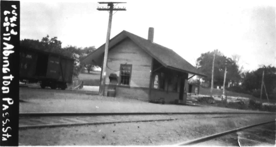
ABINGTON [BH&E, 1872; NY&NE depot, 1877]
This line was opened in 1872 by the BH&E and we are not sure what structure, if any, served as a depot here before this one. The railroad commissioners said in January, 1877 that, though services in this village were better than any other point between Willimantic and Putnam, there was a need for "suitable facilities," including a station master and better accommodation for freight, here and elsewhere in the town of Pomfret. By their next report, they said that "suitable passenger-station houses" had been built at ABINGTON, ELLIOTS and POMFRET. The val photo on the left is dated 6/8/1917. This station stood at least until 1938, as indicated on the photo on the right. Passenger service ended with the floods of 1955. [REFS: CRC24.1877.22; CRC25.1878.36; RAM1914.433; K110; R33]
This line was opened in 1872 by the BH&E and we are not sure what structure, if any, served as a depot here before this one. The railroad commissioners said in January, 1877 that, though services in this village were better than any other point between Willimantic and Putnam, there was a need for "suitable facilities," including a station master and better accommodation for freight, here and elsewhere in the town of Pomfret. By their next report, they said that "suitable passenger-station houses" had been built at ABINGTON, ELLIOTS and POMFRET. The val photo on the left is dated 6/8/1917. This station stood at least until 1938, as indicated on the photo on the right. Passenger service ended with the floods of 1955. [REFS: CRC24.1877.22; CRC25.1878.36; RAM1914.433; K110; R33]
|

|

|
 CERM website
AIR LINE JUNCTION [NHM&W, 1873]
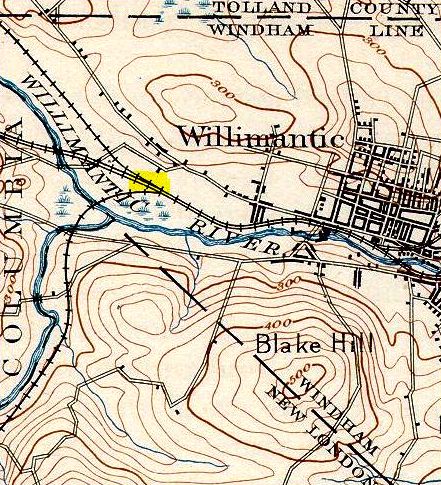
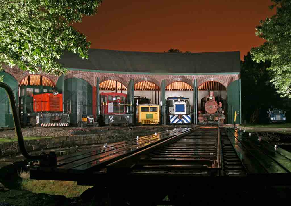
This was probably established as a stop in 1873 when the NHM&W built to a junction with the NY&NE in the town of Windham, just west of WILLIMANTIC, as seen on the 1890s maps. We note that the Hurd map [middle] says the adjacent NLN, by this time the CVT, goes to Palmyra instead of Palmer, MA! An accident was reported in 1886 wherein a westbound NY&NE passenger train bumped the rear of an eastbound Air Line train that was standing at the station here "without any signal flag on the rear end." Thus we think it at least implied that some kind of depot stood at the junction. The Air Line would use NY&NE track for the last half mile into Willimantic until lessee NYNH&H laid its own rail in the early 1890s. Though not seen thus far on timetables, as many as 16 local trains per day reportedly shuttled workers to factories here on the outskirts of the Thread City. In 1893, the railroad facilities here were upgraded and the complex was renamed COLUMBIA JUNCTION, perhaps to distinguish this location from Air Line Jct. at Cedar Hill in New Haven. The six-stall engine roundhouse and 60-ft Armstrong turntable were put in at this time. In the 3/18/1924 shot, the station may either be the passenger car or the building whose edge is seen to the right of the roundhouse. Today, this property is the home of the Connecticut Eastern Railroad Museum which has restored the engine house as seen at [4]. CERM holds an annual night photo shoot and seen here on 6/13/2009 as Trains magazine's Photo of the Day, are the six pieces of equipment arranged for the photo: (from left) a GE 44-tonner (built in 1950 for the Long Island Railroad), a Narragansett Railway speeder, a GE 45-tonner (built in 1943), a Fairmont railbus, a GE 25-tonner (built in 1958), and a Baldwin 0-4-0T (built in 1934). [REFS: NHER/06/30/1879/04; NHER/10/07/1886/04; HC/03/31/1893/06][rev121216, 092322]
This was probably established as a stop in 1873 when the NHM&W built to a junction with the NY&NE in the town of Windham, just west of WILLIMANTIC, as seen on the 1890s maps. We note that the Hurd map [middle] says the adjacent NLN, by this time the CVT, goes to Palmyra instead of Palmer, MA! An accident was reported in 1886 wherein a westbound NY&NE passenger train bumped the rear of an eastbound Air Line train that was standing at the station here "without any signal flag on the rear end." Thus we think it at least implied that some kind of depot stood at the junction. The Air Line would use NY&NE track for the last half mile into Willimantic until lessee NYNH&H laid its own rail in the early 1890s. Though not seen thus far on timetables, as many as 16 local trains per day reportedly shuttled workers to factories here on the outskirts of the Thread City. In 1893, the railroad facilities here were upgraded and the complex was renamed COLUMBIA JUNCTION, perhaps to distinguish this location from Air Line Jct. at Cedar Hill in New Haven. The six-stall engine roundhouse and 60-ft Armstrong turntable were put in at this time. In the 3/18/1924 shot, the station may either be the passenger car or the building whose edge is seen to the right of the roundhouse. Today, this property is the home of the Connecticut Eastern Railroad Museum which has restored the engine house as seen at [4]. CERM holds an annual night photo shoot and seen here on 6/13/2009 as Trains magazine's Photo of the Day, are the six pieces of equipment arranged for the photo: (from left) a GE 44-tonner (built in 1950 for the Long Island Railroad), a Narragansett Railway speeder, a GE 45-tonner (built in 1943), a Fairmont railbus, a GE 25-tonner (built in 1958), and a Baldwin 0-4-0T (built in 1934). [REFS: NHER/06/30/1879/04; NHER/10/07/1886/04; HC/03/31/1893/06][rev121216, 092322]

|
|
|
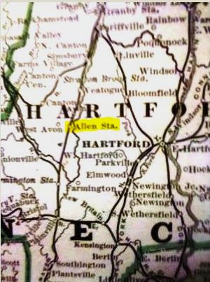
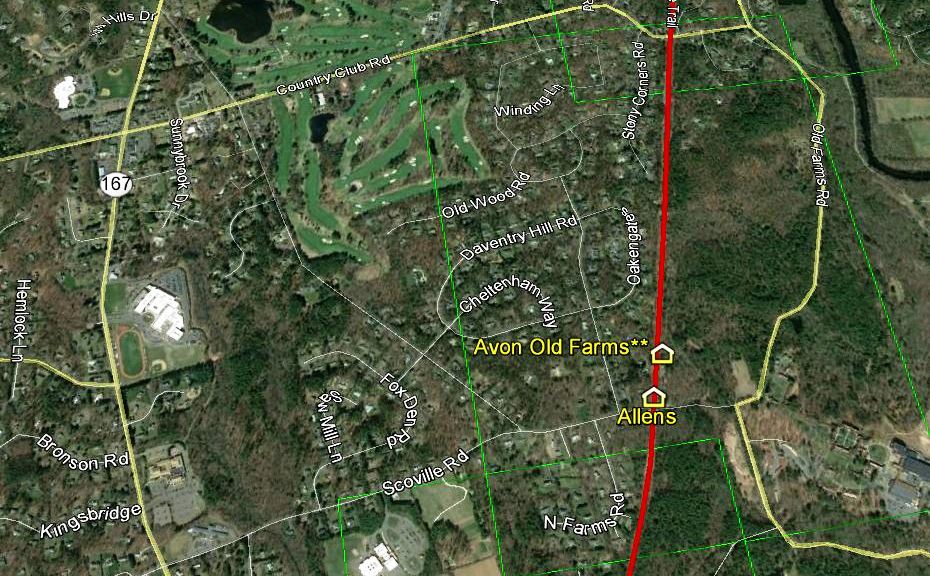
ALLENS [NH&N, 1850]
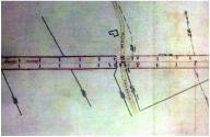
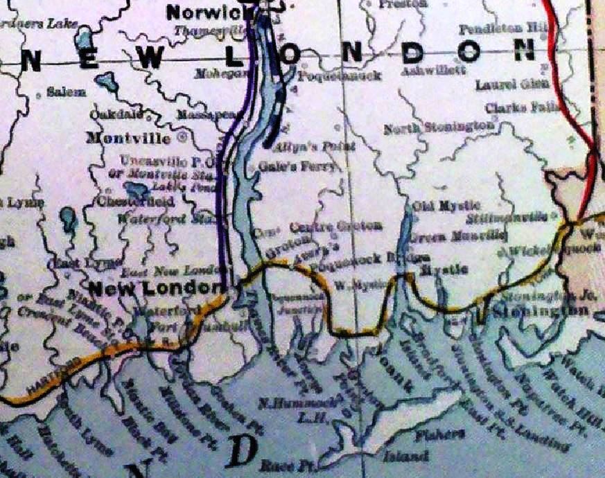
This was a stop established by the NY&NH in the town of Avon during its lease and operation of the Canal line from 1848 to 1869. It was also known as WEST AVON. The railroad built a platform here and, starting in 1850, halted the morning down-train and the evening up-train, as well as providing a flag and a lantern for passengers to signal that they were waiting. Since there was no station building, the items were kept at an adjacent home where passengers waited as well. The NH&N, newly independent as of 7/1/1869, decided to end service here and at BROOKS in Cheshire on 8/1/1869 without the permission of the railroad commissioners, such allowance for abandonment being needed for stations in existence for more than 12 months. This action apparently provoked ongoing opposition from the public so that the Canal line had to go to the commissioners four years later to receive that permission on 11/18/1873 but, upon further complaint, a superior court judge ordered the NH&N to reestablish the station. The railroad then appealed to the state Supreme Court of Errors, which reversed the lower court's writ of mandamus, saying that this stop had never been officially established, had never appeared on a timetable, had no shelter provided by the railroad, and had relied on adjacent stations for ticketing. While the high court found that BROOKS had been duly established and was reinstated until legally abandoned later, the clear-cut case here for lack of establishment immediately won the day. Oddly enough, the otherwise reliable 1886 Cram map at [4] -- the only one we have ever seen to show this stop [yellow highlight] -- lists it some 14 years after it was discontinued. An interesting statement in the high court's opinion acknowledges what we have learned from our research, that there were other stations like this "which were not so marked" on official schedules, like this one that we have never seen listed on timetables. The card at [1] notes the case in the commissioners' files. The 1913 real estate map at [2] shows Allen's Crossing and the snippet from our Track 11 Google Earth map at [3] shows it at today's Scoville Rd. The AVON OLD FARMS station sits just north of this spot and the AOF school complex is seen to the right in the map image. [REFS: RRC8.378 (11/18/1873); 41 Conn. 134 (1874); HDC/02/26/1874/02; HDC/03/03/1874/03; CRC21.1874.23][rev121817]
This was a stop established by the NY&NH in the town of Avon during its lease and operation of the Canal line from 1848 to 1869. It was also known as WEST AVON. The railroad built a platform here and, starting in 1850, halted the morning down-train and the evening up-train, as well as providing a flag and a lantern for passengers to signal that they were waiting. Since there was no station building, the items were kept at an adjacent home where passengers waited as well. The NH&N, newly independent as of 7/1/1869, decided to end service here and at BROOKS in Cheshire on 8/1/1869 without the permission of the railroad commissioners, such allowance for abandonment being needed for stations in existence for more than 12 months. This action apparently provoked ongoing opposition from the public so that the Canal line had to go to the commissioners four years later to receive that permission on 11/18/1873 but, upon further complaint, a superior court judge ordered the NH&N to reestablish the station. The railroad then appealed to the state Supreme Court of Errors, which reversed the lower court's writ of mandamus, saying that this stop had never been officially established, had never appeared on a timetable, had no shelter provided by the railroad, and had relied on adjacent stations for ticketing. While the high court found that BROOKS had been duly established and was reinstated until legally abandoned later, the clear-cut case here for lack of establishment immediately won the day. Oddly enough, the otherwise reliable 1886 Cram map at [4] -- the only one we have ever seen to show this stop [yellow highlight] -- lists it some 14 years after it was discontinued. An interesting statement in the high court's opinion acknowledges what we have learned from our research, that there were other stations like this "which were not so marked" on official schedules, like this one that we have never seen listed on timetables. The card at [1] notes the case in the commissioners' files. The 1913 real estate map at [2] shows Allen's Crossing and the snippet from our Track 11 Google Earth map at [3] shows it at today's Scoville Rd. The AVON OLD FARMS station sits just north of this spot and the AOF school complex is seen to the right in the map image. [REFS: RRC8.378 (11/18/1873); 41 Conn. 134 (1874); HDC/02/26/1874/02; HDC/03/03/1874/03; CRC21.1874.23][rev121817]
|
|

|
|
Max Miller Collection
|
|
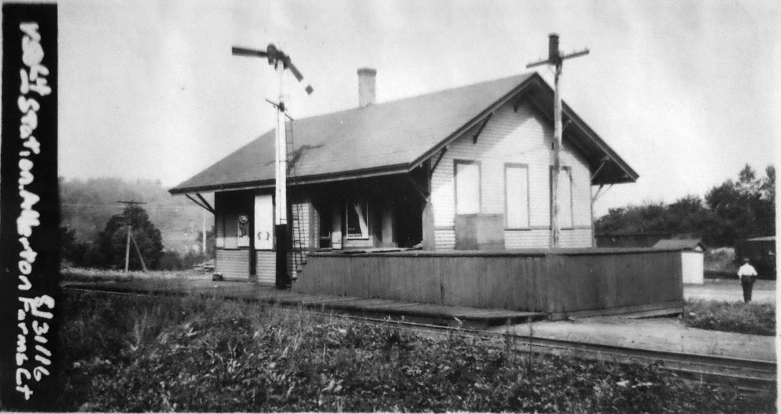
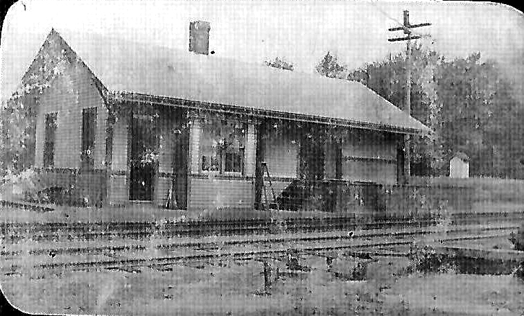
ALLERTON FARMS [NYNE c1890, opened as OSBORNTOWN]
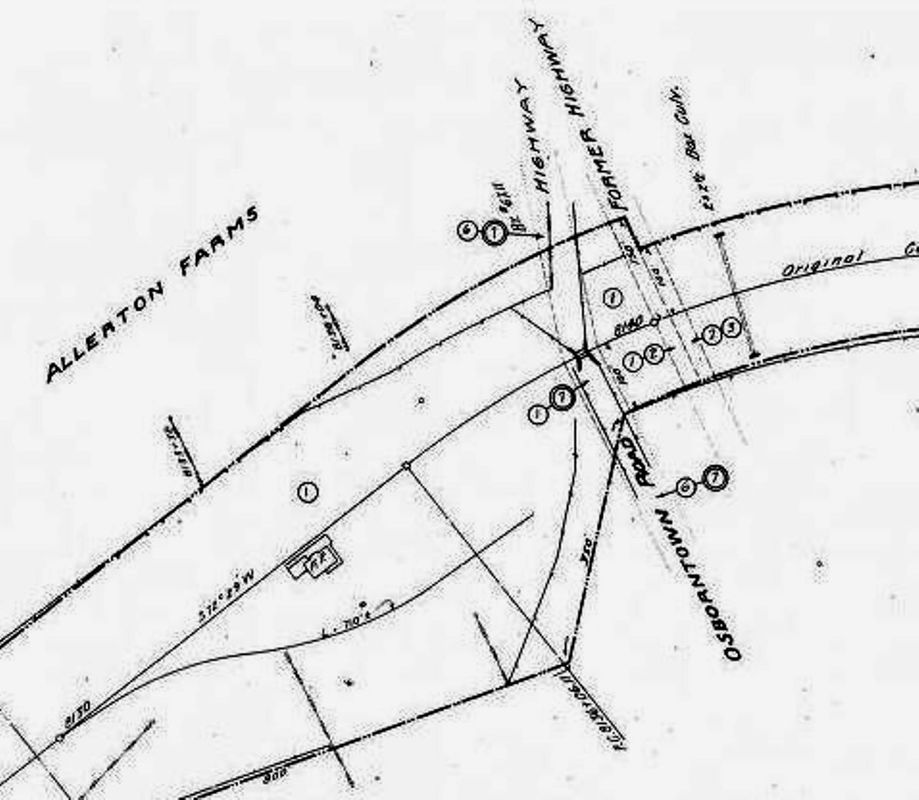
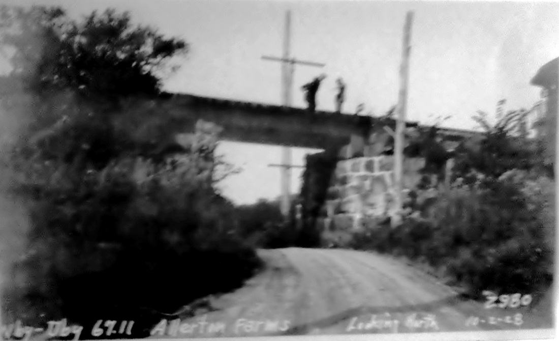
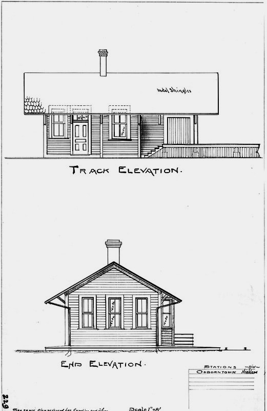
The first timetable we have that shows OSBORNTOWN as a station in the northerly part of the town of Naugatuck is 1891 and it may have been a flag stop as far back as 1881 when the NY&NE opened its extension from Waterbury to Brewster and the Hudson River shortly thereafter. Whatever its previous status, we have just come across this special legislative act in 1899: "Resolved by this Assembly: Section 1. That the New York, New Haven and Hartford Railroad Company and the New England Railroad Company are hereby authorized and empowered to locate, construct, maintain, and use a passenger and freight station at Osborntown on the Highland division... such station being between the present stations at Union City and Bradley's. Sec. 2. Said railroad companies have the right and are hereby empowered and directed, to discontinue the passenger and freight stations now maintained at said Union City and Bradley's. Approved, June 13, 1889." While we will try to remember to look in the future, this is the first time we have ever seen the legislature directly involved in the creation of a new railroad station and the abandonment of old ones. It is also interesting that the railroad commissioners reports say nothing of these events in which these officials had always played a role in the past and probably did behind the scenes here as well. These operational developments were undoubtedly connected with the NYNH&H's complete takeover of the NY&NE in 1898 and its wish to cut costs and hammer the new property into shape. The very first newspaper references to this locale come with a short-lived plan in 1880 for a rail spur to connect the borough of Naugatuck directly with the NY&NE that was about to open. The next mentions are an unbelievable string of five collisions (1891, 1892, 1893, 1899, 1904), in each case between two freight trains taking or failing to take the siding between BRADLEYS and OSBORNTOWN. Some of these wrecks were newsworthy enough to make it to the Newburgh Daily Journal, the Pawtucket Times and newspapers across the nation. The 1915 val maps show a 3800-ft passing track, possibly lengthened by the NYNH&H by that time, as the presumed scene of the accidents in the preceding years. These distressing events were punctuated in 1894 by a Courant article which said that the newly successful NY&NE block system between Plainville and Waterbury was going to be extended to Hawleyville "as soon as telegraph offices can be built at Osborntown and Newtown." Assuming this was done, at least two more accidents occurred here in spite of the precaution. The 8/31/1916 val photo at [1] shows the station in the architect's sketch at [7], which calls it OSBORNTOWN on the Highland Division of the NYNH&H. Cut off at bottom left the words seem to say "See same plan reversed for Carolina and others" and the Carolina, RI depot is, in fact, has a trackside design with the freight area on the opposite end. The best estimate of the build date is ca. 1900, The 1893 Hurd map at [3] predates the stop but Charlie Dunn's arrow points to its location. The val map at [4] shows the arrangement of facilities here in 1915 under the ALLERTON FARMS name which begins to appear on timetables around 1904. The depot is seen north of the track and on the east side of Osborntown Rd. The photo at [5] shows the 10/2/1928 PUC inspection of the bridge just west of the station. George M. Allerton, a highly regarded entrepreneur in Naugatuck's rubber industry, owned considerable property in this area. While no exact circumstance of the renaming has been found, we wonder if the influence of John H. Whittemore, a NYNH&H director and Naugatuck philanthropist who arranged for the Henry Bacon-designed NAUGATUCK3, played a role in getting ALLERTON FARMS named for a fellow industrialist in his town. The snippet at [6] is from our Track 11 Google Earth map. [REFS: SR/03/11/1880/06; NHER/03/12/1880/04; NYH/07/04/1891/04; HC/08/03/1893/06; NDJ/01/07/1893/02; DEN/01/06/1893/04; HC/12/06/1894/08; 1899 Conn. Spec. Act 405; BA53.1900.66 (3/12/1899); PT/04/13/1904/08; D135][rev030518]
The first timetable we have that shows OSBORNTOWN as a station in the northerly part of the town of Naugatuck is 1891 and it may have been a flag stop as far back as 1881 when the NY&NE opened its extension from Waterbury to Brewster and the Hudson River shortly thereafter. Whatever its previous status, we have just come across this special legislative act in 1899: "Resolved by this Assembly: Section 1. That the New York, New Haven and Hartford Railroad Company and the New England Railroad Company are hereby authorized and empowered to locate, construct, maintain, and use a passenger and freight station at Osborntown on the Highland division... such station being between the present stations at Union City and Bradley's. Sec. 2. Said railroad companies have the right and are hereby empowered and directed, to discontinue the passenger and freight stations now maintained at said Union City and Bradley's. Approved, June 13, 1889." While we will try to remember to look in the future, this is the first time we have ever seen the legislature directly involved in the creation of a new railroad station and the abandonment of old ones. It is also interesting that the railroad commissioners reports say nothing of these events in which these officials had always played a role in the past and probably did behind the scenes here as well. These operational developments were undoubtedly connected with the NYNH&H's complete takeover of the NY&NE in 1898 and its wish to cut costs and hammer the new property into shape. The very first newspaper references to this locale come with a short-lived plan in 1880 for a rail spur to connect the borough of Naugatuck directly with the NY&NE that was about to open. The next mentions are an unbelievable string of five collisions (1891, 1892, 1893, 1899, 1904), in each case between two freight trains taking or failing to take the siding between BRADLEYS and OSBORNTOWN. Some of these wrecks were newsworthy enough to make it to the Newburgh Daily Journal, the Pawtucket Times and newspapers across the nation. The 1915 val maps show a 3800-ft passing track, possibly lengthened by the NYNH&H by that time, as the presumed scene of the accidents in the preceding years. These distressing events were punctuated in 1894 by a Courant article which said that the newly successful NY&NE block system between Plainville and Waterbury was going to be extended to Hawleyville "as soon as telegraph offices can be built at Osborntown and Newtown." Assuming this was done, at least two more accidents occurred here in spite of the precaution. The 8/31/1916 val photo at [1] shows the station in the architect's sketch at [7], which calls it OSBORNTOWN on the Highland Division of the NYNH&H. Cut off at bottom left the words seem to say "See same plan reversed for Carolina and others" and the Carolina, RI depot is, in fact, has a trackside design with the freight area on the opposite end. The best estimate of the build date is ca. 1900, The 1893 Hurd map at [3] predates the stop but Charlie Dunn's arrow points to its location. The val map at [4] shows the arrangement of facilities here in 1915 under the ALLERTON FARMS name which begins to appear on timetables around 1904. The depot is seen north of the track and on the east side of Osborntown Rd. The photo at [5] shows the 10/2/1928 PUC inspection of the bridge just west of the station. George M. Allerton, a highly regarded entrepreneur in Naugatuck's rubber industry, owned considerable property in this area. While no exact circumstance of the renaming has been found, we wonder if the influence of John H. Whittemore, a NYNH&H director and Naugatuck philanthropist who arranged for the Henry Bacon-designed NAUGATUCK3, played a role in getting ALLERTON FARMS named for a fellow industrialist in his town. The snippet at [6] is from our Track 11 Google Earth map. [REFS: SR/03/11/1880/06; NHER/03/12/1880/04; NYH/07/04/1891/04; HC/08/03/1893/06; NDJ/01/07/1893/02; DEN/01/06/1893/04; HC/12/06/1894/08; 1899 Conn. Spec. Act 405; BA53.1900.66 (3/12/1899); PT/04/13/1904/08; D135][rev030518]
ALLINGS CROSSING [> SHELDONS]
ALLINGTOWN [> WEST HAVEN/D]
ALLYNDALE [> EAST CANAAN]
ALLYNS POINT1 [N&W, 1843]
This stop in the town of Ledyard was established in 1843, three years after the N&W opened with Norwich its southern terminus. The new, warmer water steamboat dock here was less prone to freezing in the winter than the NORWICH2 facility. It is a virtual certainty that a station or stations stood here in the fifty or so years before the successor in our next entry was built, but we have no photo yet.

|
|

|
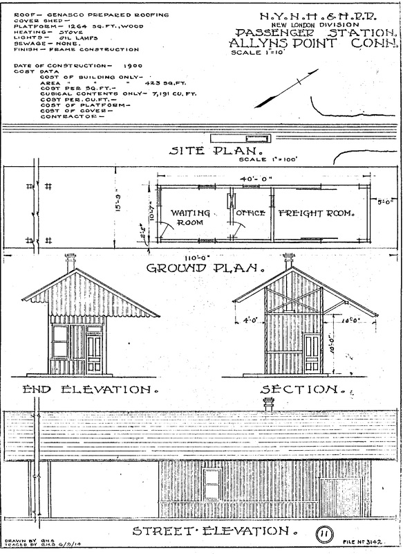
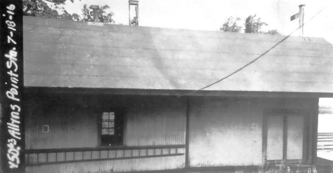
ALLYNS POINT2 [NYNH&H, 1900]
With the addition of the data sheet at [3], we now know that the station seen here was built in 1900, making it certain that there was an earlier structure that served for over 50 years. This construction date coincides with the opening of the Groton Extension in 1899 after the NYNH&H's acquisition of the N&W/NY&NE in 1898 and evidently was part of the improvements to the new property. The 1916 val photo at [2] shows the rear side of this depot with double freight doors that match the ones on the track side, an aspect of the design of this economy-sized saltbox station that we had not seen before. [rev121216]
With the addition of the data sheet at [3], we now know that the station seen here was built in 1900, making it certain that there was an earlier structure that served for over 50 years. This construction date coincides with the opening of the Groton Extension in 1899 after the NYNH&H's acquisition of the N&W/NY&NE in 1898 and evidently was part of the improvements to the new property. The 1916 val photo at [2] shows the rear side of this depot with double freight doors that match the ones on the track side, an aspect of the design of this economy-sized saltbox station that we had not seen before. [rev121216]
AMSTON [> TURNERVILLE]
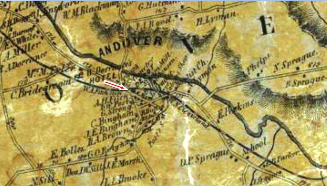
ANDOVER1 [HP&F, 1849]
This was an original HP&F stop in 1849 and the location is shown on the 1857TC map. We have no photos of the first station which burned on 6/30/1880 in a fire that "endangered a good part of the village." Newspaper articles report that the noon fire was thought to have been caused by sparks from a passing train and "...the very active work of a large number of men alone saved a number of buildings from destruction. The post office was kept in the depot. The letters were saved but some money was lost. Two or three tons of freight were thrown into the street, and some salt and meal were lost. A sleigh and other articles were burned." [REFS: NHJC/07/01/1880/04; NHJC/07/02/1880/05][rev102721]
This was an original HP&F stop in 1849 and the location is shown on the 1857TC map. We have no photos of the first station which burned on 6/30/1880 in a fire that "endangered a good part of the village." Newspaper articles report that the noon fire was thought to have been caused by sparks from a passing train and "...the very active work of a large number of men alone saved a number of buildings from destruction. The post office was kept in the depot. The letters were saved but some money was lost. Two or three tons of freight were thrown into the street, and some salt and meal were lost. A sleigh and other articles were burned." [REFS: NHJC/07/01/1880/04; NHJC/07/02/1880/05][rev102721]

Phil Wooding Collection
|
 National Archives National Archives
|

|
|
|
Max Miller Collection
|
 Al Lawrence Collection
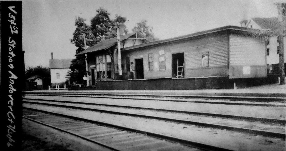
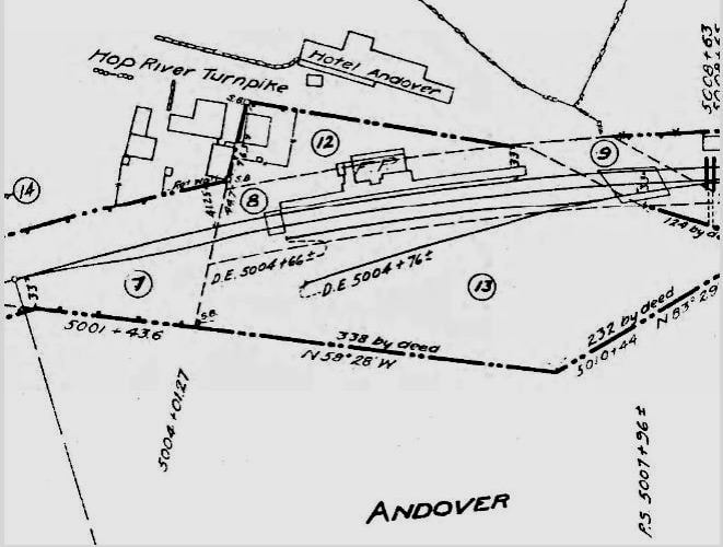
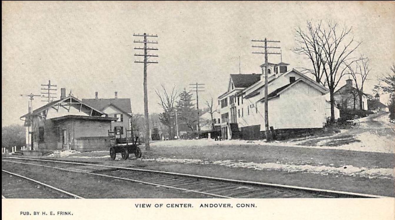
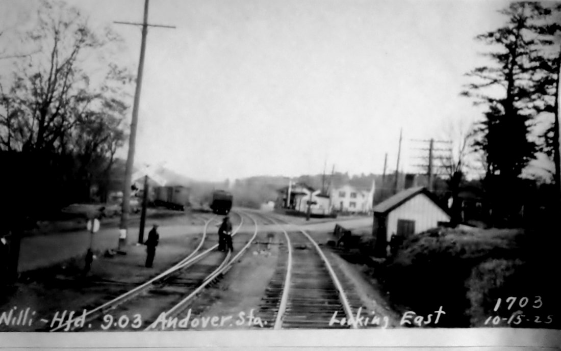
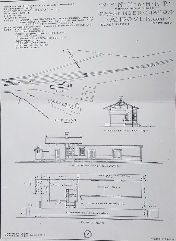
ANDOVER2 [NY&NE, 1881]
This station structure was built early in 1881 to replace its predecessor which burned in 1880. The image at [1] is undated but shows the station in all its small-town glory. The 7/21/1916 valuation photo at [2] looks southeast and gives us a glimpse of the passenger station beyond the freight depot in the foreground. The eastward shot at [3] dates to 1927. On a copy we have, it is so inscribed by Irving N. Drake, companion of Lewis H. Benton whose sequentially numbered depot photos are presented throughout this website. The image at [4] is the 6/30/1915 valuation map oriented north to south. The card at [5] is postmarked 8/5/1910 and shows the Hotel Andover that the val map indicates was across the street from the station. The PUC inspection photo at [6] looks east on 10/15/1925. The architectural sketch at [7] shows the details of this passenger station. This image is one of several in the papers of the late Ed Sweeney of Norwood, MA and supplied to us by long-time contributor Richard Fleischer of Newton Centre, MA. It gives the date of the plan as September, 1880 and says also that an addition to the freight house came in 1911, likely the expanse seen on the right in the diagram starting with the second window. Passenger service lasted until 1955, presumably ending with the hurricane destruction of the Quinebaug River bridge in Putnam in that year. Freight service lingered until 1970. The state purchased the line from Hartford to Willimantic in 1973, including the South Manchester Branch. Track removal was reportedly in 1975. [REFS: TVH/02/23/1882/00; CRC29.1882.34; NYNEAR6.1881.19; HC/12/29/1950/04; HC/01/10/1973/63B; K84] [rev102721]
This station structure was built early in 1881 to replace its predecessor which burned in 1880. The image at [1] is undated but shows the station in all its small-town glory. The 7/21/1916 valuation photo at [2] looks southeast and gives us a glimpse of the passenger station beyond the freight depot in the foreground. The eastward shot at [3] dates to 1927. On a copy we have, it is so inscribed by Irving N. Drake, companion of Lewis H. Benton whose sequentially numbered depot photos are presented throughout this website. The image at [4] is the 6/30/1915 valuation map oriented north to south. The card at [5] is postmarked 8/5/1910 and shows the Hotel Andover that the val map indicates was across the street from the station. The PUC inspection photo at [6] looks east on 10/15/1925. The architectural sketch at [7] shows the details of this passenger station. This image is one of several in the papers of the late Ed Sweeney of Norwood, MA and supplied to us by long-time contributor Richard Fleischer of Newton Centre, MA. It gives the date of the plan as September, 1880 and says also that an addition to the freight house came in 1911, likely the expanse seen on the right in the diagram starting with the second window. Passenger service lasted until 1955, presumably ending with the hurricane destruction of the Quinebaug River bridge in Putnam in that year. Freight service lingered until 1970. The state purchased the line from Hartford to Willimantic in 1973, including the South Manchester Branch. Track removal was reportedly in 1975. [REFS: TVH/02/23/1882/00; CRC29.1882.34; NYNEAR6.1881.19; HC/12/29/1950/04; HC/01/10/1973/63B; K84] [rev102721]
Ansonia Library
|

|
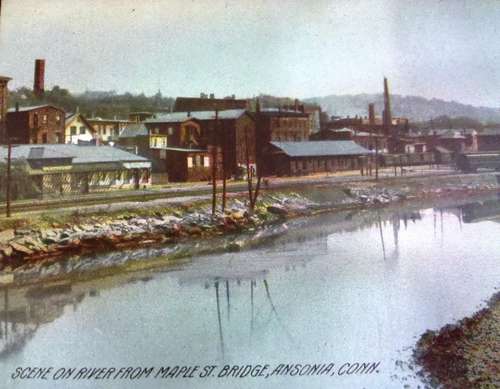
ANSONIA1 [NRR, 1849]
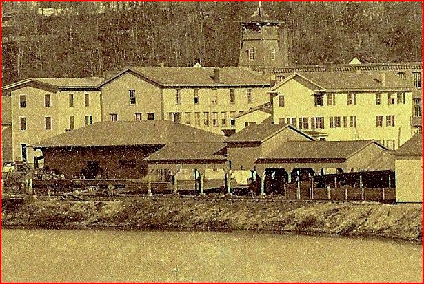
The first station here was built in 1849 by the NRR. The image is found on the 1875 Bailey bird's-eye map at right. The rare, ca. 1870, photograph on the left shows the station complete with its sizable passenger shed. The shed may have come down in 1871 to make room for the NH&D, whose track is seen in the Bailey image in the foreground on filled land and trestle work along the bank of the Naugatuck River. This station was actually in the town of Derby until 1889 when Ansonia evolved from a borough into independent town.
The first station here was built in 1849 by the NRR. The image is found on the 1875 Bailey bird's-eye map at right. The rare, ca. 1870, photograph on the left shows the station complete with its sizable passenger shed. The shed may have come down in 1871 to make room for the NH&D, whose track is seen in the Bailey image in the foreground on filled land and trestle work along the bank of the Naugatuck River. This station was actually in the town of Derby until 1889 when Ansonia evolved from a borough into independent town.
|
|
E.J. Holler Collection
|
ANSONIA2 [NRR, 1887]
The second station was completed by the NRR in January of 1887 after years of speculation about its debut. Architect Hill of Waterbury drew up the plans which were accepted in May, 1886. The new freight depot, being built first, was reportedly going to serve travelers prior to the opening of the new passenger structure that was being built on the site of the 40-year-old ANSONIA1 which was demolished. The new, steam-heated, 109x22-ft depot was to have a 66x20-ft waiting room and a ticket office in the telegraph bay on the platform. The Southern pine interior was to be complemented by pressed brick and terra cotta. Work began on the foundation in August, 1886. The railroad commissioners said the finished structure was of somewhat unique design and cost $10,000. Just a few months later on April 1, 1887, the NYNH&H would inherit this brand new structure when it leased the NRR. We thank Ed Holler for the donation of the photo at right. It shows the freight-office headhouse and the water tank atop a hexagonal brick housing with porthole window like the Canal depots of the 1870s. Water-tank architecture is a fascinating sub-topic for rail historians! Scene dates to mid-1930s and shows the old NRR main, now an industrial spur running between the structures. [REFS: CRC34.1886.8; NHDP/05/13/1886/03; NHDP/05/14/1886/03; NHER/08/17/1886/03][rev061822]
The second station was completed by the NRR in January of 1887 after years of speculation about its debut. Architect Hill of Waterbury drew up the plans which were accepted in May, 1886. The new freight depot, being built first, was reportedly going to serve travelers prior to the opening of the new passenger structure that was being built on the site of the 40-year-old ANSONIA1 which was demolished. The new, steam-heated, 109x22-ft depot was to have a 66x20-ft waiting room and a ticket office in the telegraph bay on the platform. The Southern pine interior was to be complemented by pressed brick and terra cotta. Work began on the foundation in August, 1886. The railroad commissioners said the finished structure was of somewhat unique design and cost $10,000. Just a few months later on April 1, 1887, the NYNH&H would inherit this brand new structure when it leased the NRR. We thank Ed Holler for the donation of the photo at right. It shows the freight-office headhouse and the water tank atop a hexagonal brick housing with porthole window like the Canal depots of the 1870s. Water-tank architecture is a fascinating sub-topic for rail historians! Scene dates to mid-1930s and shows the old NRR main, now an industrial spur running between the structures. [REFS: CRC34.1886.8; NHDP/05/13/1886/03; NHDP/05/14/1886/03; NHER/08/17/1886/03][rev061822]
ANSONIA3 [NYNH&H, 1903]
The station seen at left in this postcard view was nearly finished in 1903 but never saw passenger service. That it figures so prominently on the card is curious but also fortunate, since no other images of this erstwhile depot have been found. The NYNH&H belatedly realized that the location was inconvenient for public access, and the contractor, William Pattison of New Haven, soon found that the site's proximity to the river made flooding a problem even while he was putting in the foundation. The exterior of the 30x130-ft structure was faced with "buff colored, speckled brick, costing not less than $21 per thousand," presumably as seen in the postcard, and the interior, sporting an open-hearth fireplace, was to be done in "hard burned red brick" and spruce woodwork. A 1910 article in the Naugatuck Daily News sums up the handsome structure's sad history. It reads, in part, "BROOKER DIDN'T LIKE IT... So New Railroad Station in Ansonia is Being Torn Down. The railroad station which has been in process for some time past, is now being torn down. That work on it was ever started is all a mistake, and a costly one to the New York, New Haven & Hartford Railroad company... It is a little bit of a thing and is placed in one corner of the town, where no one can get to it. The street leading to it is so small that two teams can not pass through it." NYNH&H Director Charles F. Brooker's dissatisfaction with the project is made out to be the reason that the $20,000 structure was never used and he reportedly demurred by saying "That station was meant for Beacon Falls." Hardly a "little bit of a thing" -- subsequent plans in 1906 for a new station here show a footprint not much larger -- that remark must be seen as more reflective of the overall dissatisfaction with the failed project than the intent to build such a structure at the more northerly location with a much smaller population. Several Evening Sentinel articles found with citations supplied by Valley historian Rob Novak refer to this structure as "passenger station no. 2" and describe it as filling with storm water from holes in the unfinished roof and creating a public health nuisance with the stench. After seven years of this, with trains on the newly double-tracked Naugatuck Division whizzing by, the paper finally reported in July, 1910 that "an extra force of workmen attacked the structure this morning with pickaxes and crowbars. The brick walls disappeared rapidly under their onslaughts." These efforts were helped by local residents who appeared early in the mornings and "proved of material assistance," literally, by removing the interior walls and securing "abundant supplies of firewood"(!). The railroad's embarassment with this episode was revisited in 1955 when an article entitled "Flood Exposed Ansonia 'Ghost' of N.H. Railroad" recounted some of the history of the forgotten structure after the flood of August uncovered the foundation. Ironically, if the flood had not unearthed the ruins, the railroad itself might have. It had just announced plans in January, 1955 to build new 30x50-ft passenger and 30x100 freight depots north of ANSONIA2, possibly where the foundation for ANSONIA3 lay buried for half a century. This was the last in a very long series of new-station rumors dating from 1906 to 1909, culminating in an article entitled "Ansonians A Long Suffering People" who were said to be often standing in the rain to board trains at ANSONIA2 with nary a covershed. Nevertheless, ANSONIA2, seen at center in the postcard, stayed in service until the floods of 1955 and was succeeded by the modest shelter, ANSONIA4, seen in our next entry. See Track 4C, MP 4.69, 4.74, 4.74.1 for more. [REFS: ES/10/27/1902/02; ES/12/22/1902/03; CRC51.1903.20; ES/12/16/1908/05; ES/06/19/1909/02; ES/07/09/1909/04; ES/12/07/1909/04; ES/12/08/1909/06; ES/07/09/1910/03(??); ES/09/03/1910/03; NDN/10/22/ 1910/01; ES/01/19/1955/3; ES/09/06/1955/02]
The station seen at left in this postcard view was nearly finished in 1903 but never saw passenger service. That it figures so prominently on the card is curious but also fortunate, since no other images of this erstwhile depot have been found. The NYNH&H belatedly realized that the location was inconvenient for public access, and the contractor, William Pattison of New Haven, soon found that the site's proximity to the river made flooding a problem even while he was putting in the foundation. The exterior of the 30x130-ft structure was faced with "buff colored, speckled brick, costing not less than $21 per thousand," presumably as seen in the postcard, and the interior, sporting an open-hearth fireplace, was to be done in "hard burned red brick" and spruce woodwork. A 1910 article in the Naugatuck Daily News sums up the handsome structure's sad history. It reads, in part, "BROOKER DIDN'T LIKE IT... So New Railroad Station in Ansonia is Being Torn Down. The railroad station which has been in process for some time past, is now being torn down. That work on it was ever started is all a mistake, and a costly one to the New York, New Haven & Hartford Railroad company... It is a little bit of a thing and is placed in one corner of the town, where no one can get to it. The street leading to it is so small that two teams can not pass through it." NYNH&H Director Charles F. Brooker's dissatisfaction with the project is made out to be the reason that the $20,000 structure was never used and he reportedly demurred by saying "That station was meant for Beacon Falls." Hardly a "little bit of a thing" -- subsequent plans in 1906 for a new station here show a footprint not much larger -- that remark must be seen as more reflective of the overall dissatisfaction with the failed project than the intent to build such a structure at the more northerly location with a much smaller population. Several Evening Sentinel articles found with citations supplied by Valley historian Rob Novak refer to this structure as "passenger station no. 2" and describe it as filling with storm water from holes in the unfinished roof and creating a public health nuisance with the stench. After seven years of this, with trains on the newly double-tracked Naugatuck Division whizzing by, the paper finally reported in July, 1910 that "an extra force of workmen attacked the structure this morning with pickaxes and crowbars. The brick walls disappeared rapidly under their onslaughts." These efforts were helped by local residents who appeared early in the mornings and "proved of material assistance," literally, by removing the interior walls and securing "abundant supplies of firewood"(!). The railroad's embarassment with this episode was revisited in 1955 when an article entitled "Flood Exposed Ansonia 'Ghost' of N.H. Railroad" recounted some of the history of the forgotten structure after the flood of August uncovered the foundation. Ironically, if the flood had not unearthed the ruins, the railroad itself might have. It had just announced plans in January, 1955 to build new 30x50-ft passenger and 30x100 freight depots north of ANSONIA2, possibly where the foundation for ANSONIA3 lay buried for half a century. This was the last in a very long series of new-station rumors dating from 1906 to 1909, culminating in an article entitled "Ansonians A Long Suffering People" who were said to be often standing in the rain to board trains at ANSONIA2 with nary a covershed. Nevertheless, ANSONIA2, seen at center in the postcard, stayed in service until the floods of 1955 and was succeeded by the modest shelter, ANSONIA4, seen in our next entry. See Track 4C, MP 4.69, 4.74, 4.74.1 for more. [REFS: ES/10/27/1902/02; ES/12/22/1902/03; CRC51.1903.20; ES/12/16/1908/05; ES/06/19/1909/02; ES/07/09/1909/04; ES/12/07/1909/04; ES/12/08/1909/06; ES/07/09/1910/03(??); ES/09/03/1910/03; NDN/10/22/ 1910/01; ES/01/19/1955/3; ES/09/06/1955/02]

ANSONIA4 [NYNH&H, 1955]

|

|
ARNOLDS [CV, 1871; depot, 1872]
This was established as a flag stop in the town of Haddam on opening day in 1871. With the newspaper reporting that the local populace wanted a full station, CV Director Isaac Arnold undertook the construction himself and the depot seen here, the only one to stand at this location, was accepted by the railroad late the next year. It was sold and dismantled, probably in in the 1930s after passenger service was discontinued early in that decade. [REFS: HDC/08/25/1871/02; DC/12/25/1872/03; MM][rev121216]
This was established as a flag stop in the town of Haddam on opening day in 1871. With the newspaper reporting that the local populace wanted a full station, CV Director Isaac Arnold undertook the construction himself and the depot seen here, the only one to stand at this location, was accepted by the railroad late the next year. It was sold and dismantled, probably in in the 1930s after passenger service was discontinued early in that decade. [REFS: HDC/08/25/1871/02; DC/12/25/1872/03; MM][rev121216]
|
|

|
AVERYS [NYP&B, 1890?]
This was an obscure stop halfway between GROTON and POQUONNOCK, as seen on the 1894 Cram map at [1]. The 5/18/1891 New York, Providence & Boston timetable at [2] concurs, more or less, as does a September, 1893 public timetable for the NYNH&H, which got control of the line in 1892. While the precise location is unclear, we have placed it at a road accessing Avery Point on Long Island Sound, which we presume was the purpose of the stop, perhaps only used seasonally since the May timetable shows no trains stopping here in the spring. We have no further information. [add011523]
This was an obscure stop halfway between GROTON and POQUONNOCK, as seen on the 1894 Cram map at [1]. The 5/18/1891 New York, Providence & Boston timetable at [2] concurs, more or less, as does a September, 1893 public timetable for the NYNH&H, which got control of the line in 1892. While the precise location is unclear, we have placed it at a road accessing Avery Point on Long Island Sound, which we presume was the purpose of the stop, perhaps only used seasonally since the May timetable shows no trains stopping here in the spring. We have no further information. [add011523]
Dave Peters Collection
|

|

|

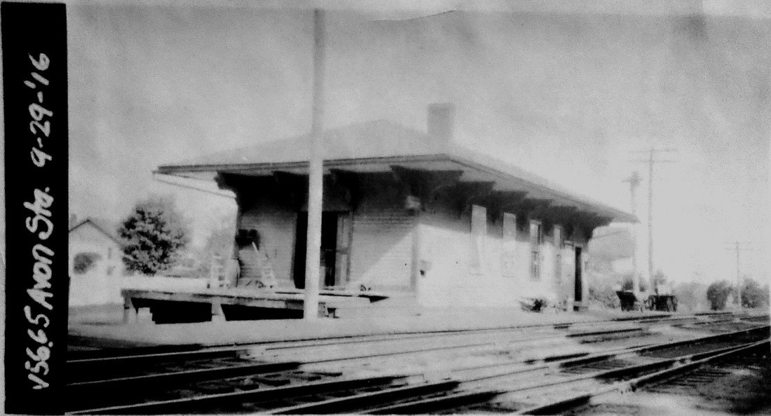
AVON [NH&N, 1848]
This structure was built by the NY&NH while it was the lessee of the Canal line. According to the railroad commissioners, it was "neatly and substantially rebuilt" in 1880, which we once thought meant it had been replaced. Happily, whatever the modifications, it is the 1848 station that is still in use today [3] as a hair salon on Simsbury Rd. and its architecture shows it true to others of the period like SIMSBURY1 and GRANBY. The val photo at [1] was taken on 9/29/1916. The 1855HC map at [4] shows the original location on Rte. 44. [REFS: CRC28.1881.17; D10; R33][rev121216]
This structure was built by the NY&NH while it was the lessee of the Canal line. According to the railroad commissioners, it was "neatly and substantially rebuilt" in 1880, which we once thought meant it had been replaced. Happily, whatever the modifications, it is the 1848 station that is still in use today [3] as a hair salon on Simsbury Rd. and its architecture shows it true to others of the period like SIMSBURY1 and GRANBY. The val photo at [1] was taken on 9/29/1916. The 1855HC map at [4] shows the original location on Rte. 44. [REFS: CRC28.1881.17; D10; R33][rev121216]

|

|
AVON OLD FARMS [NYNH&H, 1923]
This station was built as part of the famed boys' prep school founded by Theodate Pope Riddle, Connecticut's first licensed female architect. She designed the Avon Old Farms campus buildings and the unique railroad station that was situated on the Canal line near the school entrance. The slate-roofed structure, the first building to be constructed, was finished in 1923, an event that may be indicative of the importance of rail access at that time. This photo on the left was taken in the 1980s after the station had been renovated as a guest cottage. The one on the right was shot on 8/1/2010. Lord says this stop handled mostly mail and freight, but it undoubtedly served students as well, much like SOUTH KENT did for the Kent School in the town of that name. [REFS: HC/03/15/1921/15; D110]
This station was built as part of the famed boys' prep school founded by Theodate Pope Riddle, Connecticut's first licensed female architect. She designed the Avon Old Farms campus buildings and the unique railroad station that was situated on the Canal line near the school entrance. The slate-roofed structure, the first building to be constructed, was finished in 1923, an event that may be indicative of the importance of rail access at that time. This photo on the left was taken in the 1980s after the station had been renovated as a guest cottage. The one on the right was shot on 8/1/2010. Lord says this stop handled mostly mail and freight, but it undoubtedly served students as well, much like SOUTH KENT did for the Kent School in the town of that name. [REFS: HC/03/15/1921/15; D110]
AXLE SHOP [> MOUNT CARMEL1]