Track 12: CT Passenger Stations, NI-NO
See TCS Home Page links for notes, abbreviations, and sources.
Use Track 11 map link to locate stations, rail and trolley lines, and POIs.
Use Track 11 map link to locate stations, rail and trolley lines, and POIs.
NIANTIC [> EAST LYME & NIANTIC]
|
|
|
|
|
|
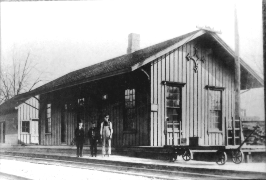
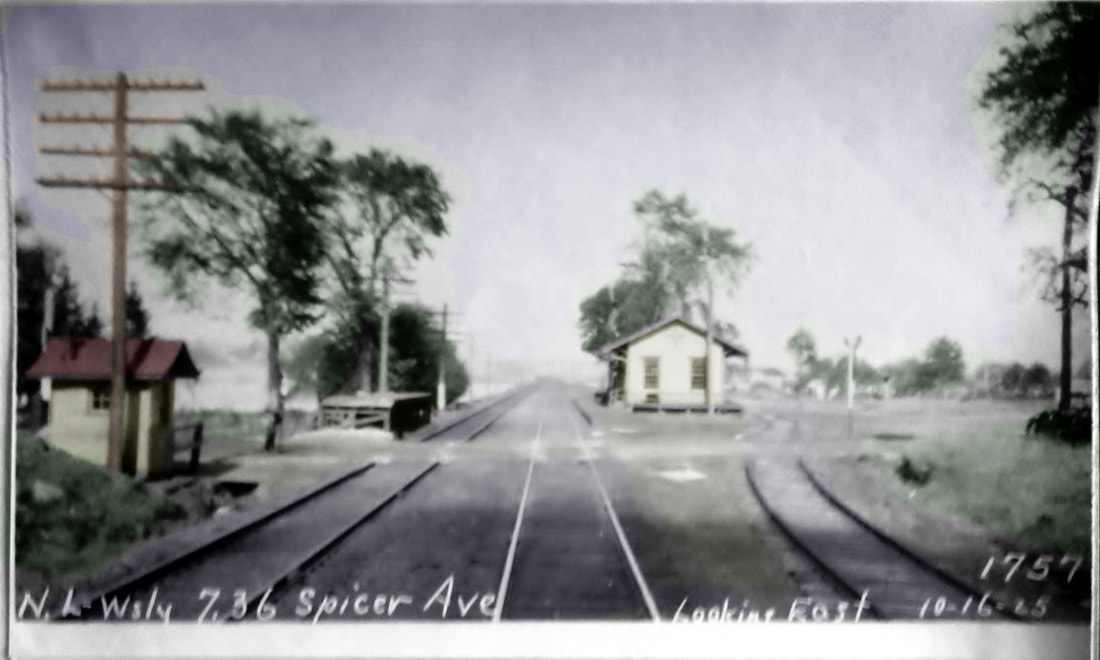
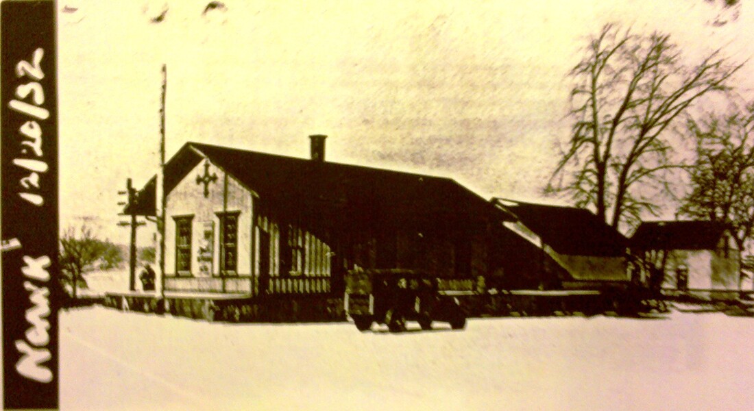
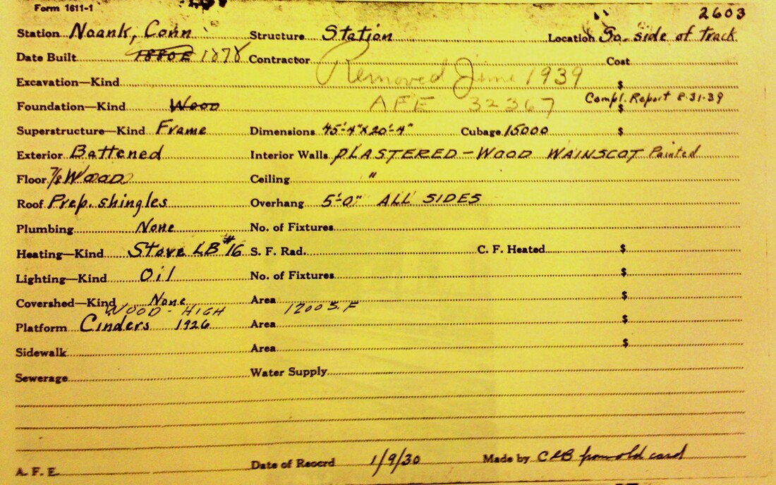
NOANK [NL&S, 1858]
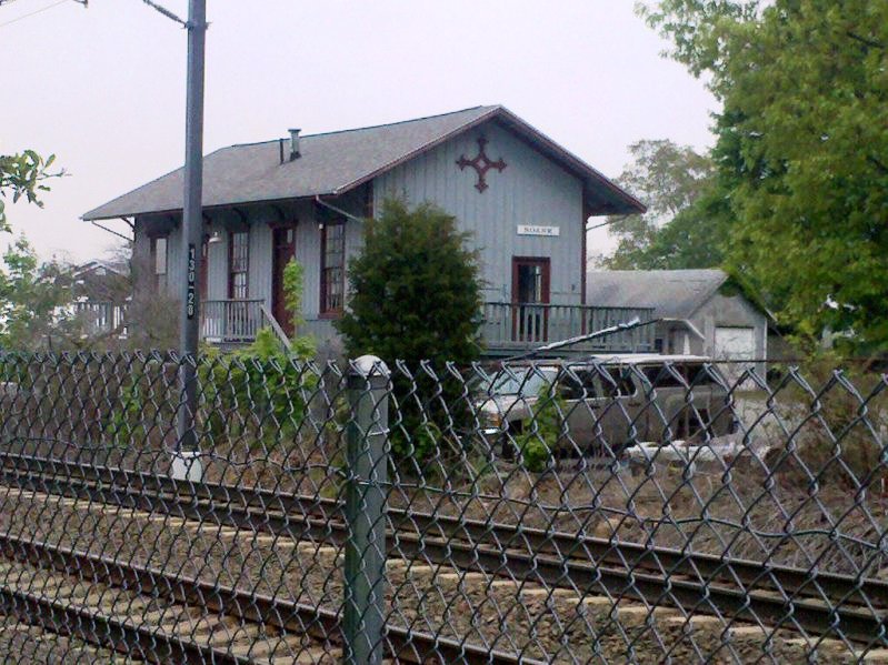
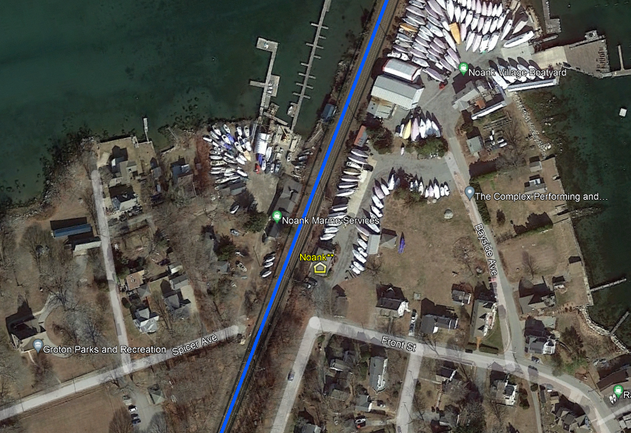
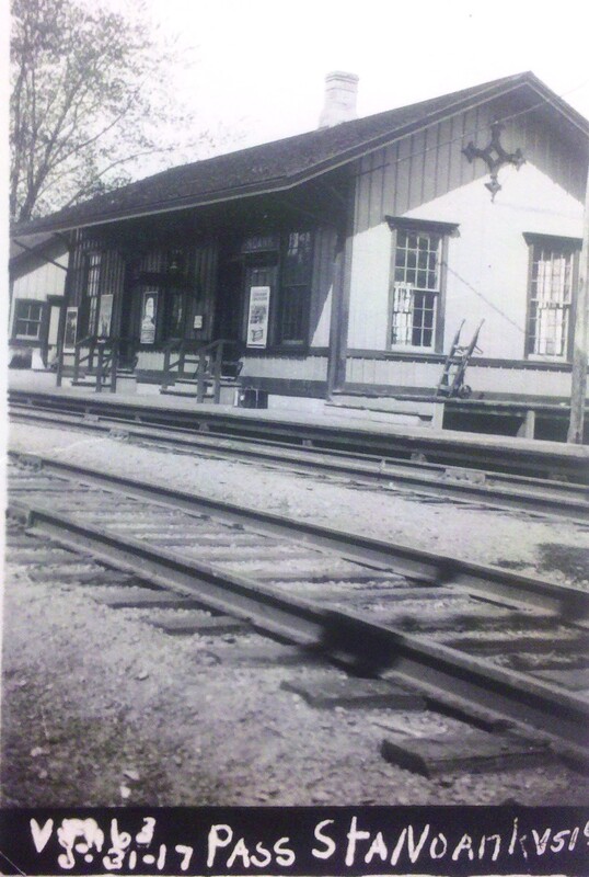
This stop was established in the town of Groton when the New London & Stonington opened in 1858 from Groton Bank to Stonington Jct. The photo at [1] looks to be ca. 1900 with the station agent and others standing in front of the station. The freight depot is behind them. The eastward-looking PUC shot at [2] is dated 10/16/1925. The 12/20/1932 photo at [3] is also from the PUC; we do not know the purpose of this shot and others from the 1930s elsewhere were taken but we appreciate the dates. The 1/9/1930 real estate card says this depot was built in 1878 but the style betrays it, like other stations marked by the distinctive 'compass' adornment, to the New York, Providence & Boston era starting in 1858. The ornaments are still in place today in WEST MYSTIC, MADISON and elsewhere. We took the photo at [5] in May, 2010. The image at [6] is a snippet from our Track 11 Google Earth map and shows the location today. The station has been moved a short distance east down the track from its original location at Spicer Ave., raised up onto a higher foundation, and, last we knew was in use today as a real estate office. The 1938 SSRR supplemental list says this station is being retained for railroad use and the real estate card at [4] tells us it was removed in June, 1939, per Authorization For Expenditure #32367. The ICC valuation photo at [7] dates to 1917. [REFS: K125, R76][rev010318, 060723]
This stop was established in the town of Groton when the New London & Stonington opened in 1858 from Groton Bank to Stonington Jct. The photo at [1] looks to be ca. 1900 with the station agent and others standing in front of the station. The freight depot is behind them. The eastward-looking PUC shot at [2] is dated 10/16/1925. The 12/20/1932 photo at [3] is also from the PUC; we do not know the purpose of this shot and others from the 1930s elsewhere were taken but we appreciate the dates. The 1/9/1930 real estate card says this depot was built in 1878 but the style betrays it, like other stations marked by the distinctive 'compass' adornment, to the New York, Providence & Boston era starting in 1858. The ornaments are still in place today in WEST MYSTIC, MADISON and elsewhere. We took the photo at [5] in May, 2010. The image at [6] is a snippet from our Track 11 Google Earth map and shows the location today. The station has been moved a short distance east down the track from its original location at Spicer Ave., raised up onto a higher foundation, and, last we knew was in use today as a real estate office. The 1938 SSRR supplemental list says this station is being retained for railroad use and the real estate card at [4] tells us it was removed in June, 1939, per Authorization For Expenditure #32367. The ICC valuation photo at [7] dates to 1917. [REFS: K125, R76][rev010318, 060723]

|

|

|
|
Norfolk Historical Society
|
Norfolk Historical Society
|
NORFOLK1 [CW, 1871]
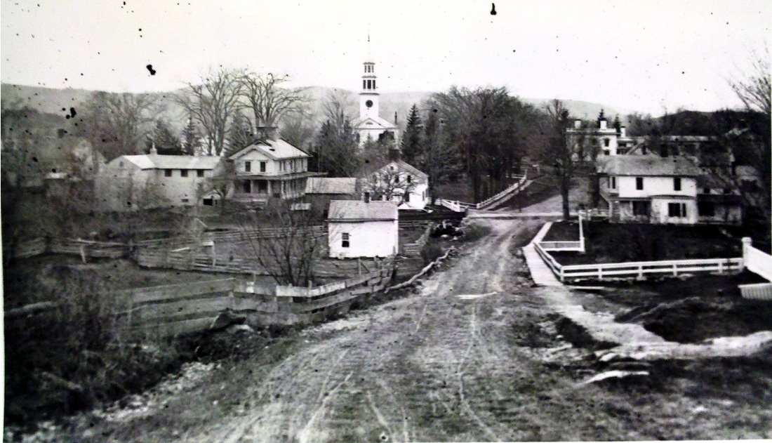
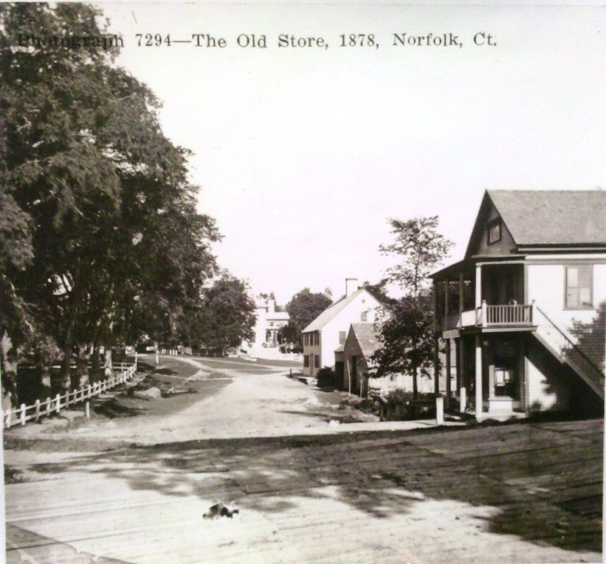
The coming of the railroad to this town was unique in several ways. With no direct railroad service residents of this town had to go either to Canaan, Winsted or Torrington to catch the train. This situation played no small role in local resident Egbert T. Butler's advocacy for the building of the CW to relieve Norfolk of its isolation. The other unusual circumstance here was that the original plans called for the rails to be laid right through the trees and war monuments on the town green. Opinions ran high against this but were countered by people who feared that the railroad might avoid the town center altogether if it didn't get the route that it wanted. The railroad commissioners had the final say and, in addition to practical considerations, they wisely disallowed the desecration "because gratitude to our noble defenders will not allow us to let a railroad run over, or seriously injure a memorial monument, dedicated to their memory, at the same time striking down in its passage trees of the century's growth, necessary to the comfort and enjoyment of the public, and for which money is no equivalent, unless we feel compelled to it by such controlling necessity as does not here exist." The result was a right of way just to the east of the green and at a low enough grade to necessitate the building of a long bridge to let the tracks pass below the busy Greenwoods Tpke. Hence was born the unique, 50-ft 'tunnel' that was part of town history for years. The photos at [1] and [2] show NORFOLK1, which was up for the opening of the CW in 1871. The 1880 NY&NE appraisal of CW properties said the building was in good condition and put a value of $1700 on it, making it comparable to BLOOMFIELD and CANTON which were similar in appearance. The photo at [3] is an eastward look through the tunnel and at [4] the PUC has the 'story stick' out to measure the tunnel's clearance in the 1920s. The other lower images look west along the turnpike, The roadway crossing over the tunnel is seen more clearly in the shot at [5] and the one at [5] clearly shows the planks that created the bridge over the tracks. The Norfolk Library [click here] now stands where the Old Store is seen, just beyond the tunnel. The church-like ambience inside is inviting, even as a bustling library goes about its business. The historical scrapbooks that we pored over are well worth asking for. Equally rewarding is a trip to the Norfolk Historical Society [click here] just across the Green where we were welcomed and treated to a large collection of railroad material, including some of the photographs seen here. [REFS: CRC17.1870.268; HDC/12/14/1871/02; WH/12/15/1871/02; D22+; R77][rev 060923]
The coming of the railroad to this town was unique in several ways. With no direct railroad service residents of this town had to go either to Canaan, Winsted or Torrington to catch the train. This situation played no small role in local resident Egbert T. Butler's advocacy for the building of the CW to relieve Norfolk of its isolation. The other unusual circumstance here was that the original plans called for the rails to be laid right through the trees and war monuments on the town green. Opinions ran high against this but were countered by people who feared that the railroad might avoid the town center altogether if it didn't get the route that it wanted. The railroad commissioners had the final say and, in addition to practical considerations, they wisely disallowed the desecration "because gratitude to our noble defenders will not allow us to let a railroad run over, or seriously injure a memorial monument, dedicated to their memory, at the same time striking down in its passage trees of the century's growth, necessary to the comfort and enjoyment of the public, and for which money is no equivalent, unless we feel compelled to it by such controlling necessity as does not here exist." The result was a right of way just to the east of the green and at a low enough grade to necessitate the building of a long bridge to let the tracks pass below the busy Greenwoods Tpke. Hence was born the unique, 50-ft 'tunnel' that was part of town history for years. The photos at [1] and [2] show NORFOLK1, which was up for the opening of the CW in 1871. The 1880 NY&NE appraisal of CW properties said the building was in good condition and put a value of $1700 on it, making it comparable to BLOOMFIELD and CANTON which were similar in appearance. The photo at [3] is an eastward look through the tunnel and at [4] the PUC has the 'story stick' out to measure the tunnel's clearance in the 1920s. The other lower images look west along the turnpike, The roadway crossing over the tunnel is seen more clearly in the shot at [5] and the one at [5] clearly shows the planks that created the bridge over the tracks. The Norfolk Library [click here] now stands where the Old Store is seen, just beyond the tunnel. The church-like ambience inside is inviting, even as a bustling library goes about its business. The historical scrapbooks that we pored over are well worth asking for. Equally rewarding is a trip to the Norfolk Historical Society [click here] just across the Green where we were welcomed and treated to a large collection of railroad material, including some of the photographs seen here. [REFS: CRC17.1870.268; HDC/12/14/1871/02; WH/12/15/1871/02; D22+; R77][rev 060923]

|

|
|
|

|

|
NORFOLK2 [PR&NE, 1898]
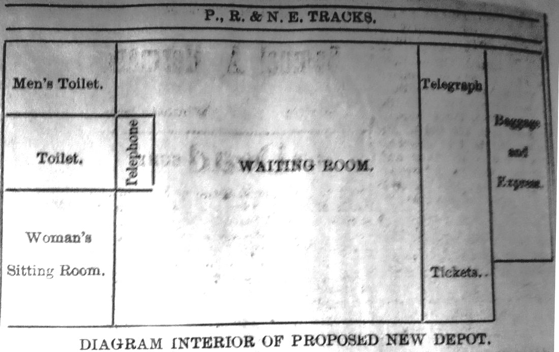
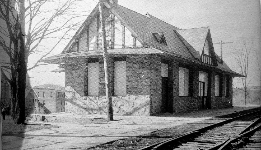
"Practically completed" by 8/18/1898, this depot was evidently the idea of the PR&NE who reportedly started negotiations with locals for building a new depot in 1895, cost projected at $5000 to be shared equally by the town and the railroad. When finished, the cost was double that. Hill & Turner, a New York architectural firm, drew up the plans that called for a 76x30-ft granite building, with 320 feet of covered platform and a semi-circular driveway leading to the covered coach port, the porte cochere, as seen at [1]. The trackside view at [2] shows the platform covershed. As the floor plan from the April 15th newspaper at [3] shows, the station on the west side of the track had the offices, baggage, and express rooms in the north end of the building and the rest rooms, ladies' sitting rooms, and telephone booth were on the south end. The lot, a little east of NORFOLK1, was donated by the Battell family. One newspaper reported that "Norfolk's princely railroad depot is now practically completed" and that local residents had furnished framed photographs of world-travel scenes and a elegant clock for the interior. As late as 1904 the Springfield Republican was still remarking that the walls inside "instead of being covered with flaring railroad advertisements, are ornamented with fine views of beautiful buildings and landscapes -- a little art gallery, in short, for eyes that are weary of cinders and smoke and time-tables." In 1925, when passenger service only would last two years more, it was Norfolk, the town that wanted the railroad so much in the 1860s, that was petitioning the PUC for more trains. The covershed is gone in the shot at [4] but the porte cochere endures, as seen at [5]. We don't know when the tunnel was filled but the 2011 view at [6] shows the old ornamental railings still gracing the crest of the hill with a sloping, grassy path has replacing the right of way. It still leads to the station building and a playground-size, wooden train does its best to commemorate the days when the real ones ran a few feet away. [REFS: CWN/06/27/1895/03; CRC46.1898.23; HC/02/11/1898/07; WEC/02/12/1898/00; CWN/02/24/1898/02; LJ/02/26/1898/01; CWN/03/24/1898/02; WEC/04/15/1898/??; CWN/04/28/1898/02; CWN/08/18/1898/02; SR/07/31/1904/11; WEC/06/24/1925/01; A38; D35; NL21.5.2; R77][rev020518, 060923]
"Practically completed" by 8/18/1898, this depot was evidently the idea of the PR&NE who reportedly started negotiations with locals for building a new depot in 1895, cost projected at $5000 to be shared equally by the town and the railroad. When finished, the cost was double that. Hill & Turner, a New York architectural firm, drew up the plans that called for a 76x30-ft granite building, with 320 feet of covered platform and a semi-circular driveway leading to the covered coach port, the porte cochere, as seen at [1]. The trackside view at [2] shows the platform covershed. As the floor plan from the April 15th newspaper at [3] shows, the station on the west side of the track had the offices, baggage, and express rooms in the north end of the building and the rest rooms, ladies' sitting rooms, and telephone booth were on the south end. The lot, a little east of NORFOLK1, was donated by the Battell family. One newspaper reported that "Norfolk's princely railroad depot is now practically completed" and that local residents had furnished framed photographs of world-travel scenes and a elegant clock for the interior. As late as 1904 the Springfield Republican was still remarking that the walls inside "instead of being covered with flaring railroad advertisements, are ornamented with fine views of beautiful buildings and landscapes -- a little art gallery, in short, for eyes that are weary of cinders and smoke and time-tables." In 1925, when passenger service only would last two years more, it was Norfolk, the town that wanted the railroad so much in the 1860s, that was petitioning the PUC for more trains. The covershed is gone in the shot at [4] but the porte cochere endures, as seen at [5]. We don't know when the tunnel was filled but the 2011 view at [6] shows the old ornamental railings still gracing the crest of the hill with a sloping, grassy path has replacing the right of way. It still leads to the station building and a playground-size, wooden train does its best to commemorate the days when the real ones ran a few feet away. [REFS: CWN/06/27/1895/03; CRC46.1898.23; HC/02/11/1898/07; WEC/02/12/1898/00; CWN/02/24/1898/02; LJ/02/26/1898/01; CWN/03/24/1898/02; WEC/04/15/1898/??; CWN/04/28/1898/02; CWN/08/18/1898/02; SR/07/31/1904/11; WEC/06/24/1925/01; A38; D35; NL21.5.2; R77][rev020518, 060923]
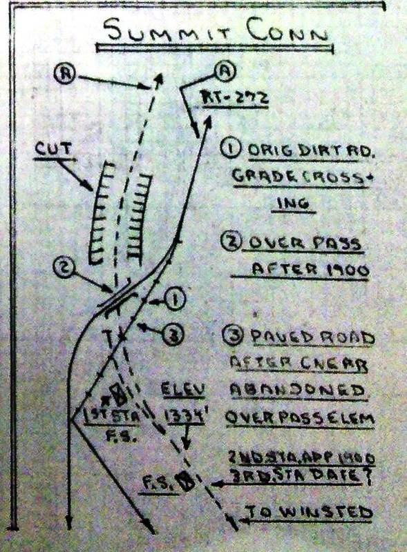
NORFOLK SUMMIT1 [CW, 1872]
This was a flag stop, also known as SUMMIT, or SPAULDINGS SUMMIT, established shortly after the opening of the CW. The Winsted Herald in April, 1872 said that... "the new milk train on the Conn. Western railroad has been the means of adding a number of new stations between Winsted and Millerton, including two between Winsted and Norfolk -- Brook's and the Summit." We do not know if there was a passenger structure here or just a platform at first. A decade later, reports in 1881 said that the H&CW was "putting in a long side track at the summit for the benefit of their numerous extra freight trains, and are soon to rebuild the dilapidated milk house at that station." The late Victor M. Newton left a sheaf of notes and detailed maps showing the development of the CNE and its predecessors over the years. The one at left shows the evolution of the stations here, the first being slightly north of the spot that would host the second and third structures. [REFS: WH/04/05/1872/02; CWN/11/02/1881/02][rev122112, 060923]
This was a flag stop, also known as SUMMIT, or SPAULDINGS SUMMIT, established shortly after the opening of the CW. The Winsted Herald in April, 1872 said that... "the new milk train on the Conn. Western railroad has been the means of adding a number of new stations between Winsted and Millerton, including two between Winsted and Norfolk -- Brook's and the Summit." We do not know if there was a passenger structure here or just a platform at first. A decade later, reports in 1881 said that the H&CW was "putting in a long side track at the summit for the benefit of their numerous extra freight trains, and are soon to rebuild the dilapidated milk house at that station." The late Victor M. Newton left a sheaf of notes and detailed maps showing the development of the CNE and its predecessors over the years. The one at left shows the evolution of the stations here, the first being slightly north of the spot that would host the second and third structures. [REFS: WH/04/05/1872/02; CWN/11/02/1881/02][rev122112, 060923]
Connecticut Historical Society
|

|
National Archives
|
|
|
|
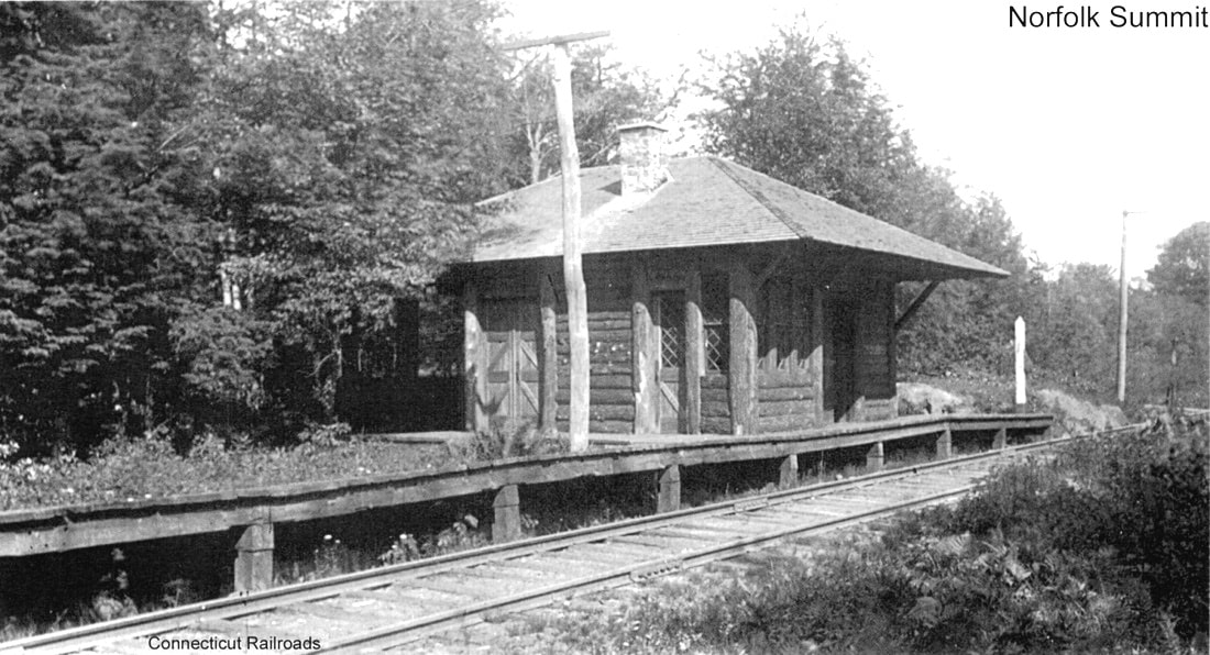
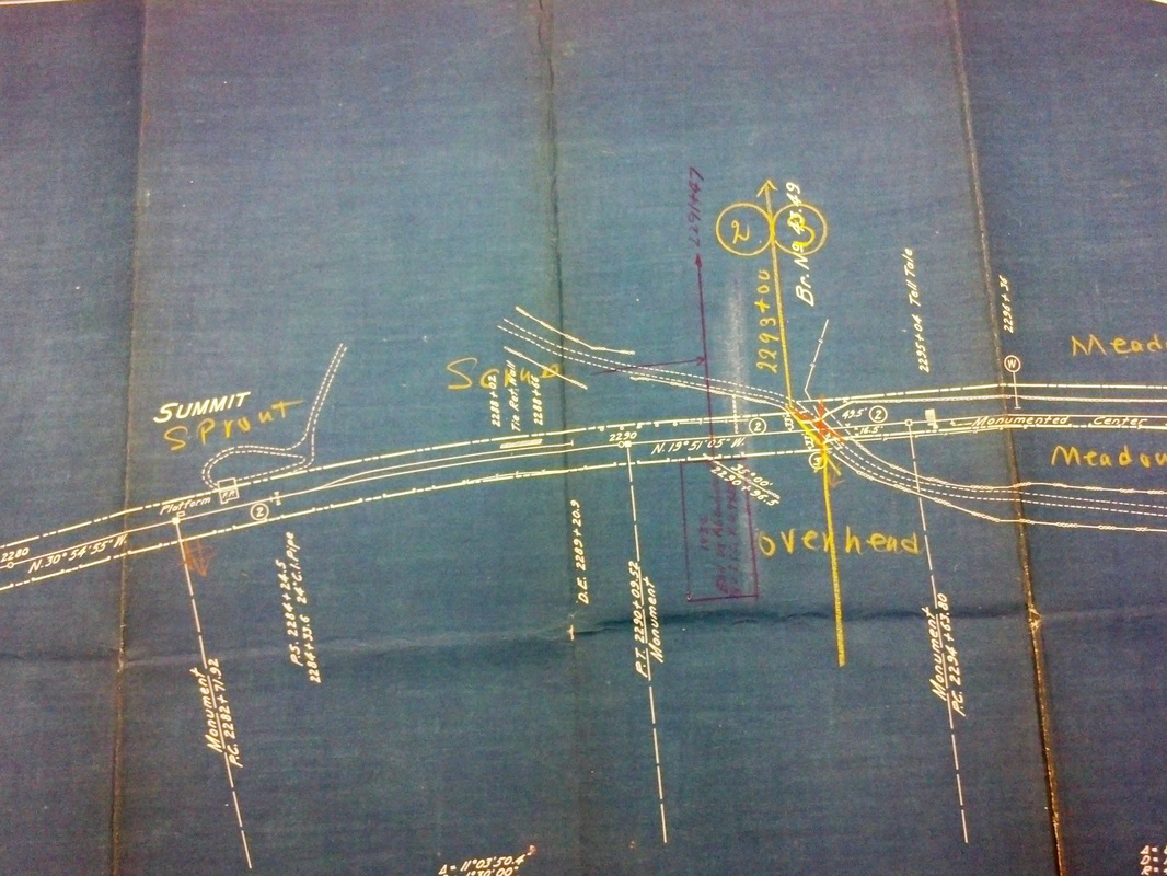
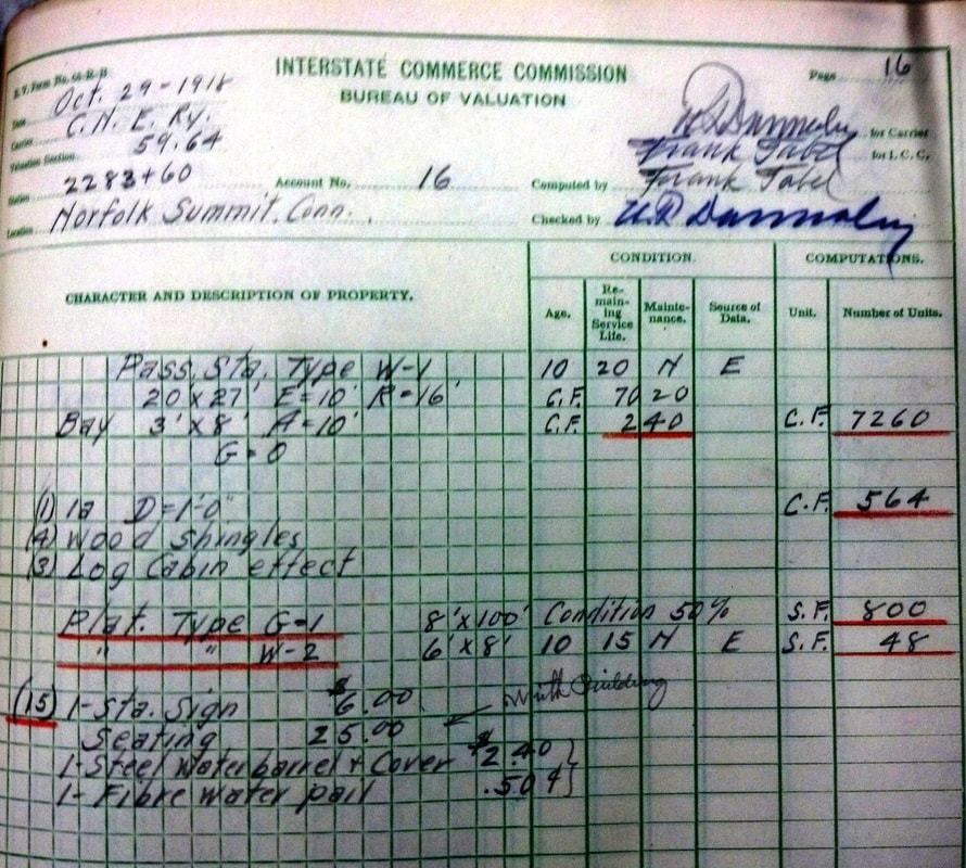
NORFOLK SUMMIT2 [CNE, 1900]
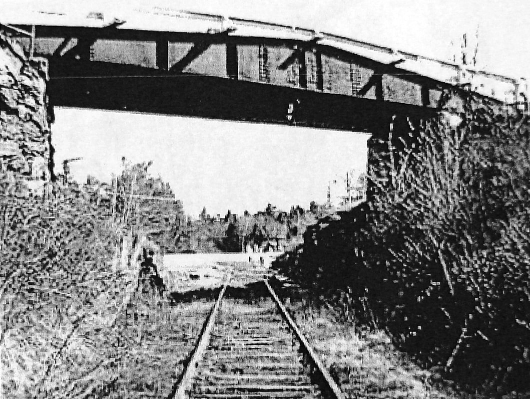
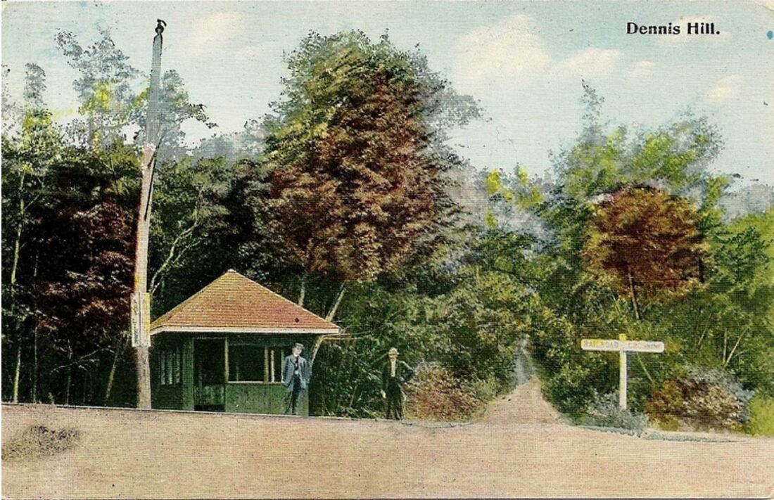
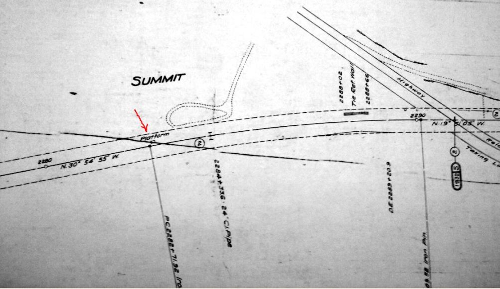
According to the newspapers, this station was being completed early in 1900 and local residents had contributed funds. It was expected to cost about $2,000 and cater mostly to summer traffic. The interior was said to consist of a waiting room with rustic fireplace, baggage room, and ticket office. Though unattended at the start, it was hoped that patronage would grow and an agent would be on duty here. The exterior was dressed, as seen, with slabs of bark giving the structure its unique, log-cabin look. A covered platform reportedly was built nearly all the way around but is never shown in the few photos that we have. The roof extended out on the west side to form a porte cochere that was built around the trunk of a hemlock tree and supported by two large hemlock posts. In the photo at [1], the darker, covered carriage porch can be seen in the rear, as well as the tree trunk acting as a center support. The post to the right of the station looks to have a paddle on it which would be raised to get trains to stop for a passenger waiting at the flag stop. In the shot at [2] the agent's bay projecting out on the left side of the building can be discerned with its shorter roof brackets. The arrangement of the grounds is seen in the 1916 ICC valuation map at [3], with the circular driveway and the station footprint showing the agent's bay. The ICC field notes at [4] give a host of details. The depot's 20x27-ft floor dimensions are supplemented with an eave measurement [E] of 10 feet and a roof height [R] of 16 feet. Bureaucratically precise computation pegs the total physical volume of station space at 7020 cu. ft., to which is added 240 cu. ft. for the 3x8x10-ft agents bay. On opening, the rustic-style station was christened NORFOLK SUMMIT and it may have seen more than its assumed share of service. Perhaps catering to affluent businessmen, a 12:52 p.m. train originating here is mentioned in the Courant in 1906 as making connections via Canaan for a 5:20 p.m. arrival in New York City. In 1915, the name of this station reverted to simply SUMMIT, presumably to avoid confusion with NORFOLK. This change was probably per ICC order No. F1611. As reproduced in Lord, the NYNH&H notification to its station agents and other interested parties had a date of 11/16/1915. According to the Courant, the CNE made the changes proactively effective on 6/6/1915. If the newspaper was correct, one wonders if any confusion was caused in the intervening months. This station burned on 8/10/1922 with the Courant reporting as follows: "The Summit station on the Central New England Railroad, which was located on the highest spot in this section of the state and which was built about twenty-five years ago mainly through subscriptions by summer residents, was burned shortly after noon today. The fire was discovered shortly after a west bound train had passed and it is believed was caused by sparks from the locomotive. There is no water supply at the Summit and in consequence little could be done to check the flames." According to an undated clipping from Ted Vaill's Winsted Herald column, it was standing when one train went by and, when the next train passed, it was gone. The shot at [5] shows the old turntable bridge used for the overpass that Newton says was installed ca. 1900 to eliminate the grade crossing. To the best of our knowledge, there was no stop at Dennis Hill, now a state park further north on Rte 272, but the card at [6] shows a small structure there clearly along the railroad track. [REFS: HDC/12/21/1871/02; WH/04/05/1872/02; CWN/01/04/1900/02; WEC/02/07/1900/00; HC/06/09/1906/09; HC/05/28/1915/06; SR/05/28/1915/04; HC/08/11/1922/04; D32,43][rev121912, 060923]
According to the newspapers, this station was being completed early in 1900 and local residents had contributed funds. It was expected to cost about $2,000 and cater mostly to summer traffic. The interior was said to consist of a waiting room with rustic fireplace, baggage room, and ticket office. Though unattended at the start, it was hoped that patronage would grow and an agent would be on duty here. The exterior was dressed, as seen, with slabs of bark giving the structure its unique, log-cabin look. A covered platform reportedly was built nearly all the way around but is never shown in the few photos that we have. The roof extended out on the west side to form a porte cochere that was built around the trunk of a hemlock tree and supported by two large hemlock posts. In the photo at [1], the darker, covered carriage porch can be seen in the rear, as well as the tree trunk acting as a center support. The post to the right of the station looks to have a paddle on it which would be raised to get trains to stop for a passenger waiting at the flag stop. In the shot at [2] the agent's bay projecting out on the left side of the building can be discerned with its shorter roof brackets. The arrangement of the grounds is seen in the 1916 ICC valuation map at [3], with the circular driveway and the station footprint showing the agent's bay. The ICC field notes at [4] give a host of details. The depot's 20x27-ft floor dimensions are supplemented with an eave measurement [E] of 10 feet and a roof height [R] of 16 feet. Bureaucratically precise computation pegs the total physical volume of station space at 7020 cu. ft., to which is added 240 cu. ft. for the 3x8x10-ft agents bay. On opening, the rustic-style station was christened NORFOLK SUMMIT and it may have seen more than its assumed share of service. Perhaps catering to affluent businessmen, a 12:52 p.m. train originating here is mentioned in the Courant in 1906 as making connections via Canaan for a 5:20 p.m. arrival in New York City. In 1915, the name of this station reverted to simply SUMMIT, presumably to avoid confusion with NORFOLK. This change was probably per ICC order No. F1611. As reproduced in Lord, the NYNH&H notification to its station agents and other interested parties had a date of 11/16/1915. According to the Courant, the CNE made the changes proactively effective on 6/6/1915. If the newspaper was correct, one wonders if any confusion was caused in the intervening months. This station burned on 8/10/1922 with the Courant reporting as follows: "The Summit station on the Central New England Railroad, which was located on the highest spot in this section of the state and which was built about twenty-five years ago mainly through subscriptions by summer residents, was burned shortly after noon today. The fire was discovered shortly after a west bound train had passed and it is believed was caused by sparks from the locomotive. There is no water supply at the Summit and in consequence little could be done to check the flames." According to an undated clipping from Ted Vaill's Winsted Herald column, it was standing when one train went by and, when the next train passed, it was gone. The shot at [5] shows the old turntable bridge used for the overpass that Newton says was installed ca. 1900 to eliminate the grade crossing. To the best of our knowledge, there was no stop at Dennis Hill, now a state park further north on Rte 272, but the card at [6] shows a small structure there clearly along the railroad track. [REFS: HDC/12/21/1871/02; WH/04/05/1872/02; CWN/01/04/1900/02; WEC/02/07/1900/00; HC/06/09/1906/09; HC/05/28/1915/06; SR/05/28/1915/04; HC/08/11/1922/04; D32,43][rev121912, 060923]
|

|
NORFOLK SUMMIT3 [CNE, 1922]
This simple shelter replaced the log-cabin station that burned in 1922. Nimke [3.56] says this photo was taken in 1928. The unidentified young man is seen in other CNE station shots of the period, sometimes with a motorbike also visible that must have transported him and the photographer on their railfanning adventures in the northwest corner. [rev121912, 060923]
This simple shelter replaced the log-cabin station that burned in 1922. Nimke [3.56] says this photo was taken in 1928. The unidentified young man is seen in other CNE station shots of the period, sometimes with a motorbike also visible that must have transported him and the photographer on their railfanning adventures in the northwest corner. [rev121912, 060923]
|

|

|
NOROTON1 [NY&NH, c1850, opens as LOCKWOODS; depot c1868?]
Seen as mistakenly called NORTON or NEWTON, this was not an original Darien stop on the NY&NH when it opened in 1849. Seven years later, however, the 1856FC map at [1] shows the DARIEN station at the blue arrow and another depot at the red arrow. This latter one was near the home of W. Lockwood and corresponds to the LOCKWOODS stop on the 1861 conductor's tally sheet at [2]. Both the 1856 map and the one at [3], which also dates to the 1850s, show the station south of the NY&NH track and at a location just east of today's Noroton Ave., then known as Railroad Ave. Nowhere else to be found in railroad documents or in travel publications like Snow's Pathfinder Railway Guide, the stop is first mentioned as NOROTON in the newspapers in 1865. By 1868, Noroton Heights, as the high ground in this southwest corner of Darien was known, with its vistas of Long Island Sound, its beautiful dwellings, and good clean air, was being touted as "... a desirable Summer residence for people desiring good society and at the same time easy and quick transit to the city, as business may demand." Access to the "flourishing village" of Stamford is also cited in the description which is aimed at the real estate market. The official timetable debut in sources we had access to was 1868 and in the next year, the Herald-Tribune said "a fine depot has recently been erected" here. It added that property values had doubled in the last three years, due certainly to the railroad providing service to this village. Even assuming that no structure preceded this 1869 station, the stop certainly predates it and goes back at least to the 1856 map. The reference to the "fine new depot" has us wondering if this was not a cross-gabled, Gothic structure akin to GREENWICH1, SOUTHPORT1, and other early NY&NH stations. NOROTON1 appears to have been removed in 1888 due to track improvements. A newspaper article said that workers had arrived to begin straightening the curve here where freight trains were having difficulty and "by so doing will do away with the old depot and erect a new one farther north." [REFS: PTH107.1858.14; CR/07/10/1858/04: Lockwood's Corner; HDC/08/05/1865/02: NEWTON; CR/08/12/1865/03; RF/08/11/1865/02; NYHT/07/27/1867/05; HDC/07/01/1868/04; NYHT/05/22/1869/04; CC/09/13/1873/04; RRC31.84 (12/22/1887); BEF/04/24/188/??] [rev061723]
Seen as mistakenly called NORTON or NEWTON, this was not an original Darien stop on the NY&NH when it opened in 1849. Seven years later, however, the 1856FC map at [1] shows the DARIEN station at the blue arrow and another depot at the red arrow. This latter one was near the home of W. Lockwood and corresponds to the LOCKWOODS stop on the 1861 conductor's tally sheet at [2]. Both the 1856 map and the one at [3], which also dates to the 1850s, show the station south of the NY&NH track and at a location just east of today's Noroton Ave., then known as Railroad Ave. Nowhere else to be found in railroad documents or in travel publications like Snow's Pathfinder Railway Guide, the stop is first mentioned as NOROTON in the newspapers in 1865. By 1868, Noroton Heights, as the high ground in this southwest corner of Darien was known, with its vistas of Long Island Sound, its beautiful dwellings, and good clean air, was being touted as "... a desirable Summer residence for people desiring good society and at the same time easy and quick transit to the city, as business may demand." Access to the "flourishing village" of Stamford is also cited in the description which is aimed at the real estate market. The official timetable debut in sources we had access to was 1868 and in the next year, the Herald-Tribune said "a fine depot has recently been erected" here. It added that property values had doubled in the last three years, due certainly to the railroad providing service to this village. Even assuming that no structure preceded this 1869 station, the stop certainly predates it and goes back at least to the 1856 map. The reference to the "fine new depot" has us wondering if this was not a cross-gabled, Gothic structure akin to GREENWICH1, SOUTHPORT1, and other early NY&NH stations. NOROTON1 appears to have been removed in 1888 due to track improvements. A newspaper article said that workers had arrived to begin straightening the curve here where freight trains were having difficulty and "by so doing will do away with the old depot and erect a new one farther north." [REFS: PTH107.1858.14; CR/07/10/1858/04: Lockwood's Corner; HDC/08/05/1865/02: NEWTON; CR/08/12/1865/03; RF/08/11/1865/02; NYHT/07/27/1867/05; HDC/07/01/1868/04; NYHT/05/22/1869/04; CC/09/13/1873/04; RRC31.84 (12/22/1887); BEF/04/24/188/??] [rev061723]

Dave Peters Collection
|
|

|
|

|
|
NOROTON2 [NYNH&H, 1888, WB]
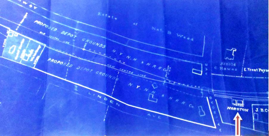
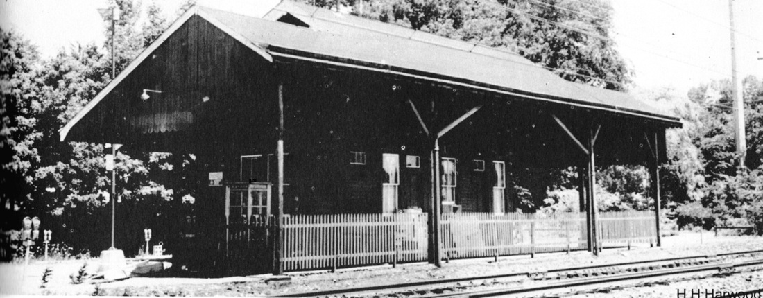
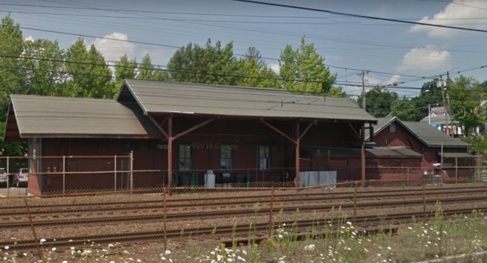
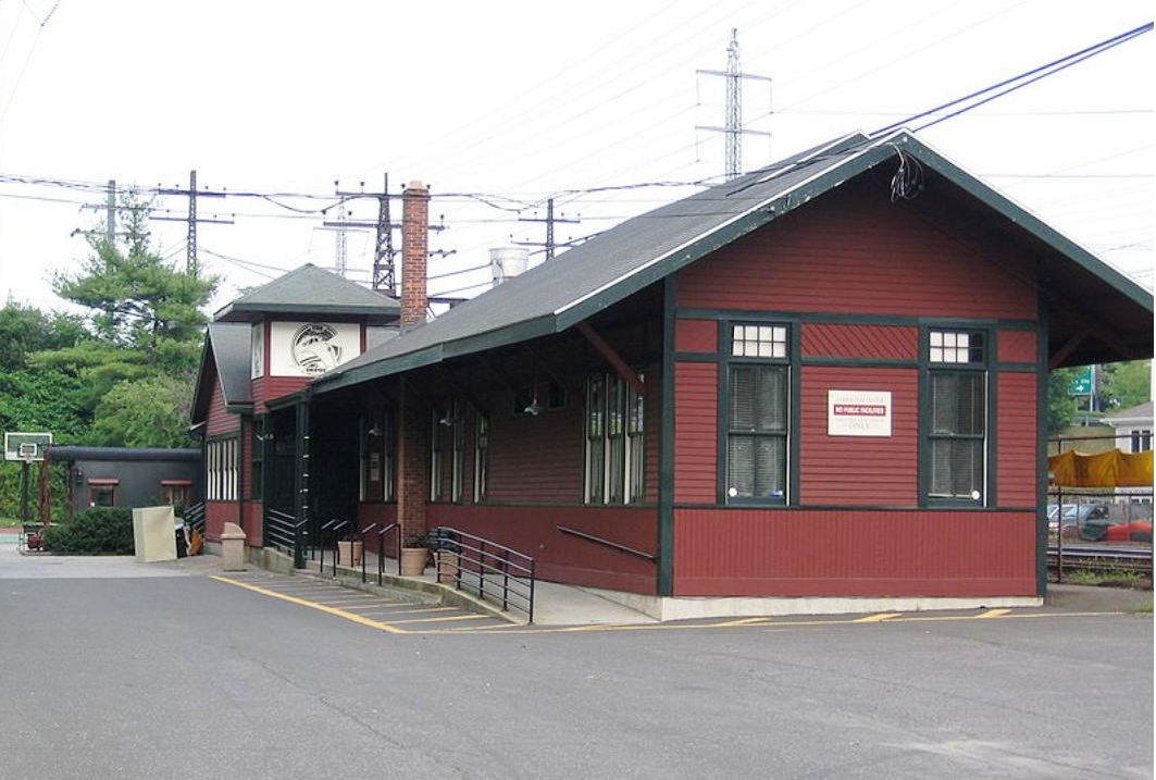
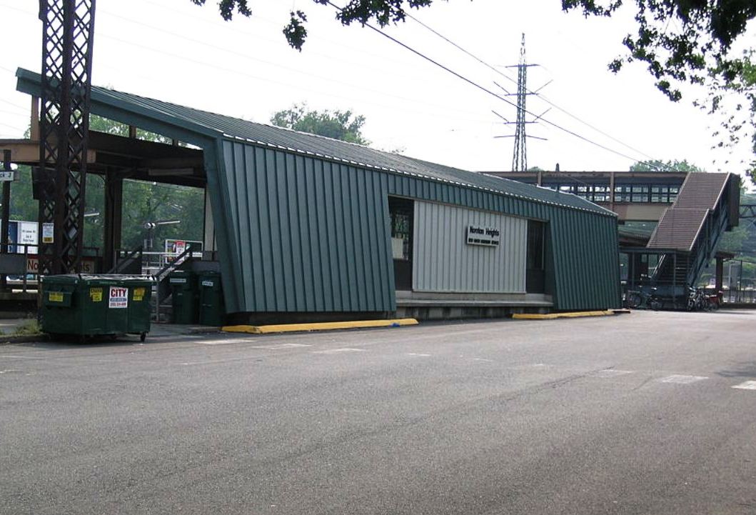
Built with the 1888 improvements, NOROTON2 was a smallish saltbox structure put up on the north, westbound, side of the tracks west of Noroton Ave. This passenger station was specifically mentioned in August, 1897, when early-morning burglars forced the door with a coupling pin and rifled the drawers in the ticket office, only to find that station agent Robert Dewitt had wisely taken all the cash home with him. A 1930 PUC photo is shown at [1]. The arrow on the ca 1888 blueprint map at [2] shows the 1850s depot location with the proposed grounds for NOROTON2 to the west. NOROTON2 was taken out of railroad service on 5/28/1974 with the inauguration of NOROTON4/5 and the high-level platforms about 1,000 feet further west. The old structure then became the base for a nationally recognized EMS service called Post 53, still in operation today but now across the track in a newer building. Threatened with demolition in 1989, NOROTON2 was subsequently turned into The Depot, a drug-free gathering spot for young people, remodeled as seen in the photos at [6] and [7]. [REFS: NHER/02/08/1897/04; NHER/08/10/1897/01; HC/05/23/1974/95D; R77][061723]
Built with the 1888 improvements, NOROTON2 was a smallish saltbox structure put up on the north, westbound, side of the tracks west of Noroton Ave. This passenger station was specifically mentioned in August, 1897, when early-morning burglars forced the door with a coupling pin and rifled the drawers in the ticket office, only to find that station agent Robert Dewitt had wisely taken all the cash home with him. A 1930 PUC photo is shown at [1]. The arrow on the ca 1888 blueprint map at [2] shows the 1850s depot location with the proposed grounds for NOROTON2 to the west. NOROTON2 was taken out of railroad service on 5/28/1974 with the inauguration of NOROTON4/5 and the high-level platforms about 1,000 feet further west. The old structure then became the base for a nationally recognized EMS service called Post 53, still in operation today but now across the track in a newer building. Threatened with demolition in 1989, NOROTON2 was subsequently turned into The Depot, a drug-free gathering spot for young people, remodeled as seen in the photos at [6] and [7]. [REFS: NHER/02/08/1897/04; NHER/08/10/1897/01; HC/05/23/1974/95D; R77][061723]

Dave Peters Collection
|
|
|

NOROTON3 [NYNH&H, c1895, EB]
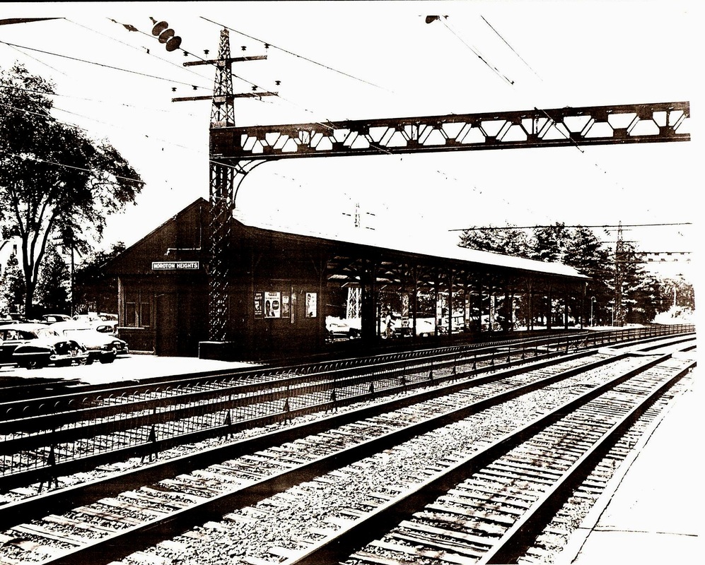
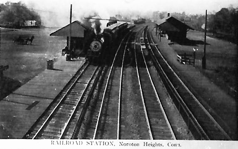
The ICC valuation photo at [1] is dated 11/1/1916 and shows the eastbound depot, NOROTON3, south of the tracks. This was an even more diminutive counterpart of its cousin across the way in the different-sized pairings that came with the four-tracking of the New York Division in the 1890s. The view at [2] also looks west as does the shot at [3]; the latter shows NOROTON3 on the left and NOROTON2 on the right. The 1915 ICC valuation map at [4] shows NOROTON2 at the red arrow and NOROTON3 at the blue arrow. This stop was renamed NOROTON HEIGHTS in 1942, reportedly to highlight access to the U.S. Navy radio school operating during World War II. The location was about a mile north and up the hill at the Fitch's Home for Soldiers and Their Orphans that dated back to the Civil War [click here]. Currently, these buildings are the Allen-O'Neill housing complex at the corner of West and Noroton Aves. NOROTON3 was removed in the McGinnis era. [REFS: NL7.8.5; NL8.2.7; R77][rev070517, 061723]
The ICC valuation photo at [1] is dated 11/1/1916 and shows the eastbound depot, NOROTON3, south of the tracks. This was an even more diminutive counterpart of its cousin across the way in the different-sized pairings that came with the four-tracking of the New York Division in the 1890s. The view at [2] also looks west as does the shot at [3]; the latter shows NOROTON3 on the left and NOROTON2 on the right. The 1915 ICC valuation map at [4] shows NOROTON2 at the red arrow and NOROTON3 at the blue arrow. This stop was renamed NOROTON HEIGHTS in 1942, reportedly to highlight access to the U.S. Navy radio school operating during World War II. The location was about a mile north and up the hill at the Fitch's Home for Soldiers and Their Orphans that dated back to the Civil War [click here]. Currently, these buildings are the Allen-O'Neill housing complex at the corner of West and Noroton Aves. NOROTON3 was removed in the McGinnis era. [REFS: NL7.8.5; NL8.2.7; R77][rev070517, 061723]
Wikipedia
|

Wikipedia
|
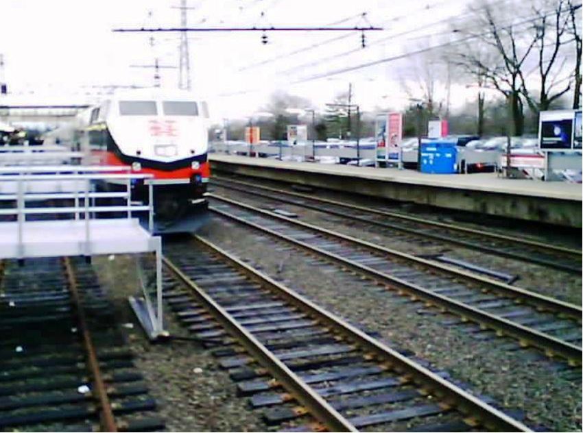
NOROTON4 [PC, c1970]
This westbound station was built in the Penn Central era to replace NOROTON2. In 1974, it was moved about 1,000 feet west on straighter track to accommodate the high-level platforms that the new M2 cars were going to use. The sleek platform canopy, the back of which is seen in the photo on the left, was designed by World Trade Center architect Minoru Yamasaki in 1955 and was apparently incorporated into the station relocation. His other railroad-station canopy at ROWAYTON4 was completely different in style. Perhaps because of the early date in his career, no newspaper articles or other documentation found thus far mention his involvement with just the two stations or, more importantly, the reason for it. Yamasaki died in 1986 [click here]. [REFS: SL13.4.28][rev061723
This westbound station was built in the Penn Central era to replace NOROTON2. In 1974, it was moved about 1,000 feet west on straighter track to accommodate the high-level platforms that the new M2 cars were going to use. The sleek platform canopy, the back of which is seen in the photo on the left, was designed by World Trade Center architect Minoru Yamasaki in 1955 and was apparently incorporated into the station relocation. His other railroad-station canopy at ROWAYTON4 was completely different in style. Perhaps because of the early date in his career, no newspaper articles or other documentation found thus far mention his involvement with just the two stations or, more importantly, the reason for it. Yamasaki died in 1986 [click here]. [REFS: SL13.4.28][rev061723
NOROTON5 [MN, 1992?]
This eastbound platform is seen on the right in the photograph.
This eastbound platform is seen on the right in the photograph.
|
|

|
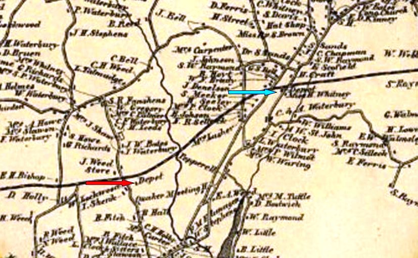
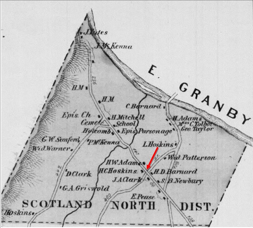
NORTH BLOOMFIELD1 [CW, 1872; opens as SCOTLAND]
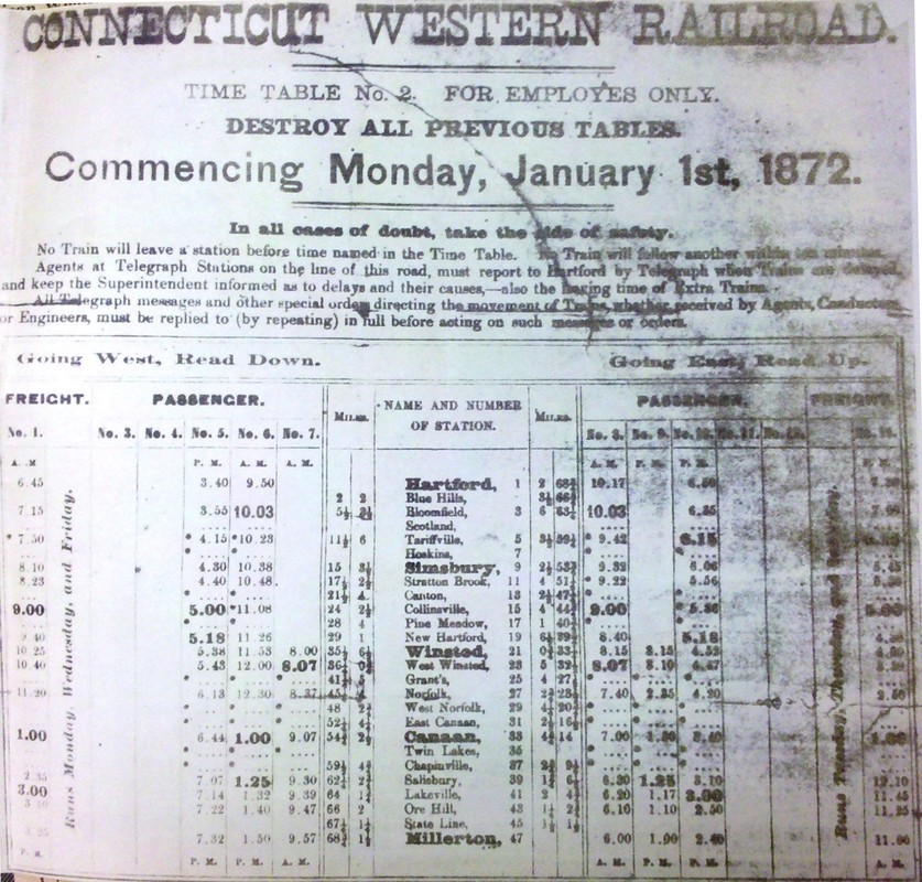
This flag stop in the town of Bloomfield originated shortly after the Connecticut Western RR opened in 1871. Its coming location is seen at our red arrow on the 1869 Baker & Tilden map at [1]. A SCOTLAND station, presumably named for the ethnicity of the early settlers in this part of Bloomfield, shows up on employee timetable #2 at [2] and on the 8/6/1882 public timetable at [3]. The stop was later renamed NORTH BLOOMFIELD by the PR&NE during its ownership beginng in 1892. We have no photos at this time of the first station structure that stood under either of these names. [rev042717, 061723]
This flag stop in the town of Bloomfield originated shortly after the Connecticut Western RR opened in 1871. Its coming location is seen at our red arrow on the 1869 Baker & Tilden map at [1]. A SCOTLAND station, presumably named for the ethnicity of the early settlers in this part of Bloomfield, shows up on employee timetable #2 at [2] and on the 8/6/1882 public timetable at [3]. The stop was later renamed NORTH BLOOMFIELD by the PR&NE during its ownership beginng in 1892. We have no photos at this time of the first station structure that stood under either of these names. [rev042717, 061723]
|
|
|
National Archives
|

|
|
 Bunny Merritt Collection, courtesy of Vicki Bale-Saunders
NORTH BLOOMFIELD2 [CNE, 1903]
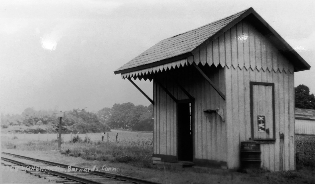
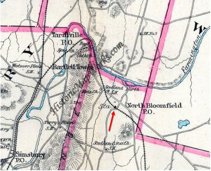
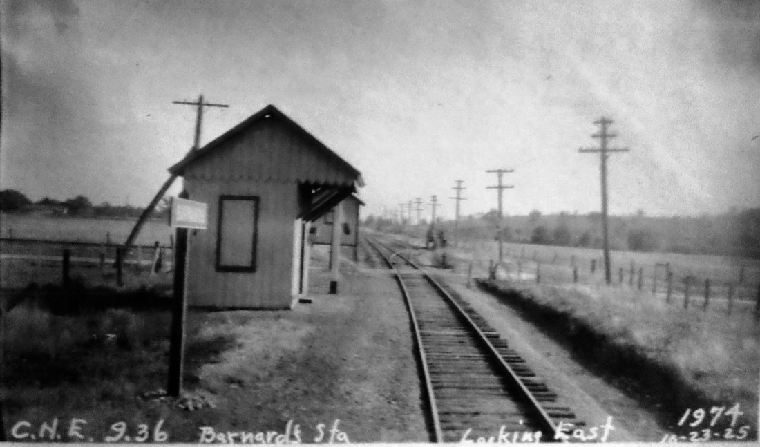
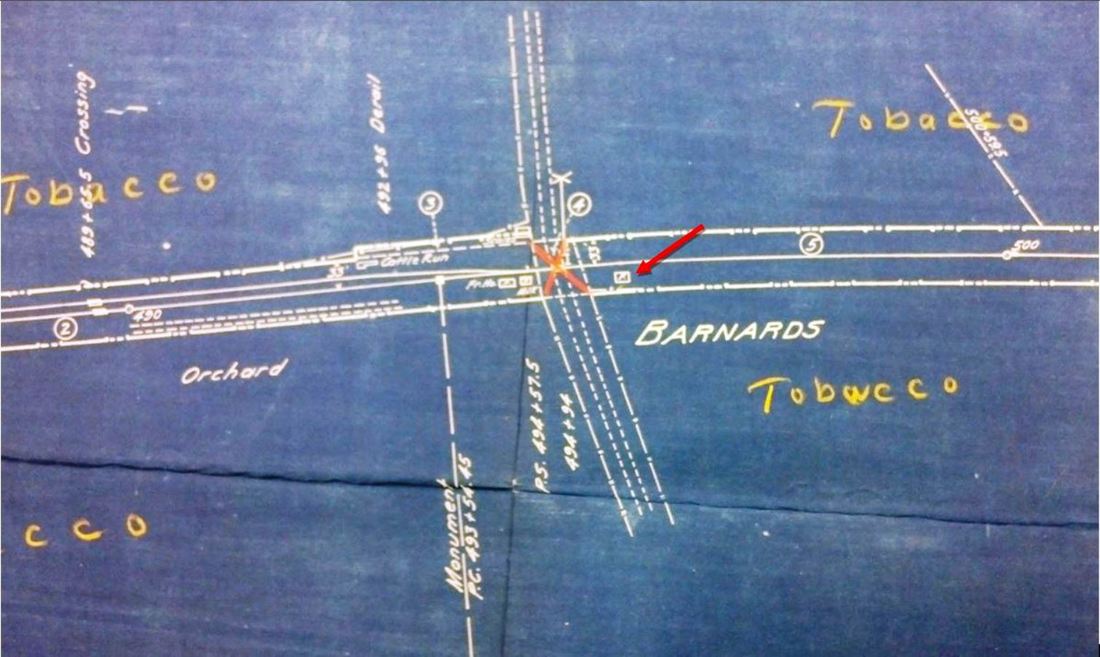
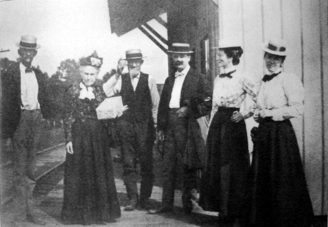
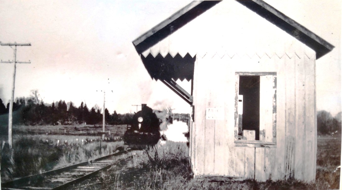
The PR&NE, which controlled the line from 1892 to 1899, renamed this stop NORTH BLOOMFIELD instead of SCOTLAND. The railroad commissioners tell us that a new station was built here in 1903. The Courant reported in that year that the CNE had wanted to abandon this location for one less than a mile north of here to accommodate the International Tobacco Corporation. Small tobacco farmers objected that they would be inconvenienced and that their rights of having a say in depot locations were due them for subsidizing the railroad when it was built. They won the day! The CNE would begin calling this station BARNARDS on 11/16/1915 following the ICC's F-1611 directive for renaming stops to avoid train-order confusion, and our 1917TT reflects the new name. Passenger service was replaced by bus on this part of the CNE on 1/17/1926, the year before the CNE's corporate existence ended when it was merged with the NYNH&H. The photo at [1] is Lewis H. Benton #2368 taken in 1929, likely in June, and refers to the station called BARNARDS at that time. The 1893 Hurd map at [2] predates the final station name change; the post office is North Bloomfield and the local schools still reflect the Scotland name. The 10/23/1925 PUC shot at [3] looks south (railroad east) and partially shows the freight house behind the passenger shed and, in the distance on the opposite side of the track, a cattle pen and run. The ICC map at [4] shows the layout with tobacco fields all around; workers were seen in the background in the photo at [1]. We think the 10/12/1933 shot at [5] was taken by someone other than Benton, but fellow photographer and 'chauffeur' Irving Drake is standing on the track. That may be Carlton Parker, another rail historian and photographer, in the station doorway. A photo in Nimke shows BARNARDS still standing in 1936 when freight service ended. The ICC gave the NYNH&H permission to abandon the CNE from CLARKVILLE, by then GRIFFINS, to Feeding Hills, Mass. in 1938. The jovial group at [6] shows Aunt Amelia Barnard, second from left, up from New York, scion of the prominent local family for whom the station was named in later days. The image at [7] shows the last train south. [REFS: HDC/12/21/1871/02; PTH18.1875.48; CRC53.1903.22; HC/06/20/1903/13; CWN/06/25/1903/02; RRC16.319 (6/26/1903); HC/07/02/1903/15; HC/11/14/1903/05; PTH517.1917.16; 1923TT; HC/01/17/1926/10; HC/01/09/1939/07; A26; D17,43 ; K115; N3.11][rev082317, 061723]
The PR&NE, which controlled the line from 1892 to 1899, renamed this stop NORTH BLOOMFIELD instead of SCOTLAND. The railroad commissioners tell us that a new station was built here in 1903. The Courant reported in that year that the CNE had wanted to abandon this location for one less than a mile north of here to accommodate the International Tobacco Corporation. Small tobacco farmers objected that they would be inconvenienced and that their rights of having a say in depot locations were due them for subsidizing the railroad when it was built. They won the day! The CNE would begin calling this station BARNARDS on 11/16/1915 following the ICC's F-1611 directive for renaming stops to avoid train-order confusion, and our 1917TT reflects the new name. Passenger service was replaced by bus on this part of the CNE on 1/17/1926, the year before the CNE's corporate existence ended when it was merged with the NYNH&H. The photo at [1] is Lewis H. Benton #2368 taken in 1929, likely in June, and refers to the station called BARNARDS at that time. The 1893 Hurd map at [2] predates the final station name change; the post office is North Bloomfield and the local schools still reflect the Scotland name. The 10/23/1925 PUC shot at [3] looks south (railroad east) and partially shows the freight house behind the passenger shed and, in the distance on the opposite side of the track, a cattle pen and run. The ICC map at [4] shows the layout with tobacco fields all around; workers were seen in the background in the photo at [1]. We think the 10/12/1933 shot at [5] was taken by someone other than Benton, but fellow photographer and 'chauffeur' Irving Drake is standing on the track. That may be Carlton Parker, another rail historian and photographer, in the station doorway. A photo in Nimke shows BARNARDS still standing in 1936 when freight service ended. The ICC gave the NYNH&H permission to abandon the CNE from CLARKVILLE, by then GRIFFINS, to Feeding Hills, Mass. in 1938. The jovial group at [6] shows Aunt Amelia Barnard, second from left, up from New York, scion of the prominent local family for whom the station was named in later days. The image at [7] shows the last train south. [REFS: HDC/12/21/1871/02; PTH18.1875.48; CRC53.1903.22; HC/06/20/1903/13; CWN/06/25/1903/02; RRC16.319 (6/26/1903); HC/07/02/1903/15; HC/11/14/1903/05; PTH517.1917.16; 1923TT; HC/01/17/1926/10; HC/01/09/1939/07; A26; D17,43 ; K115; N3.11][rev082317, 061723]

|
|
|
|
Max Miller Collection
|
|
NORTH BRIDGEPORT [HRR, c1866]
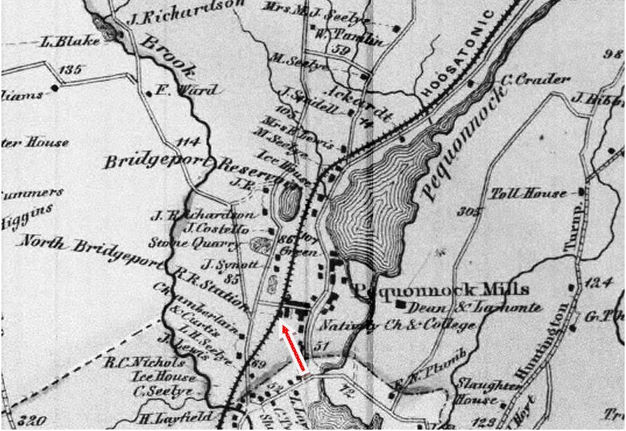
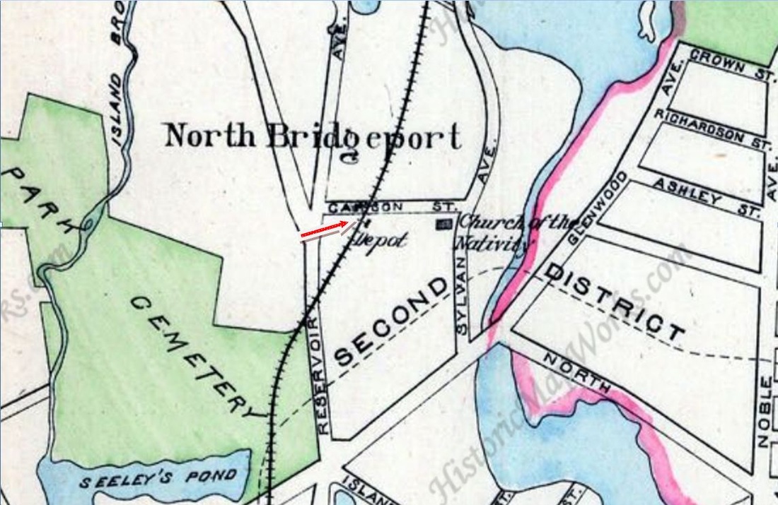
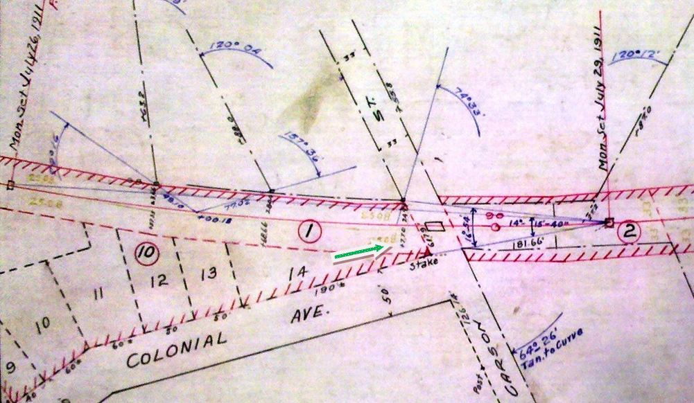
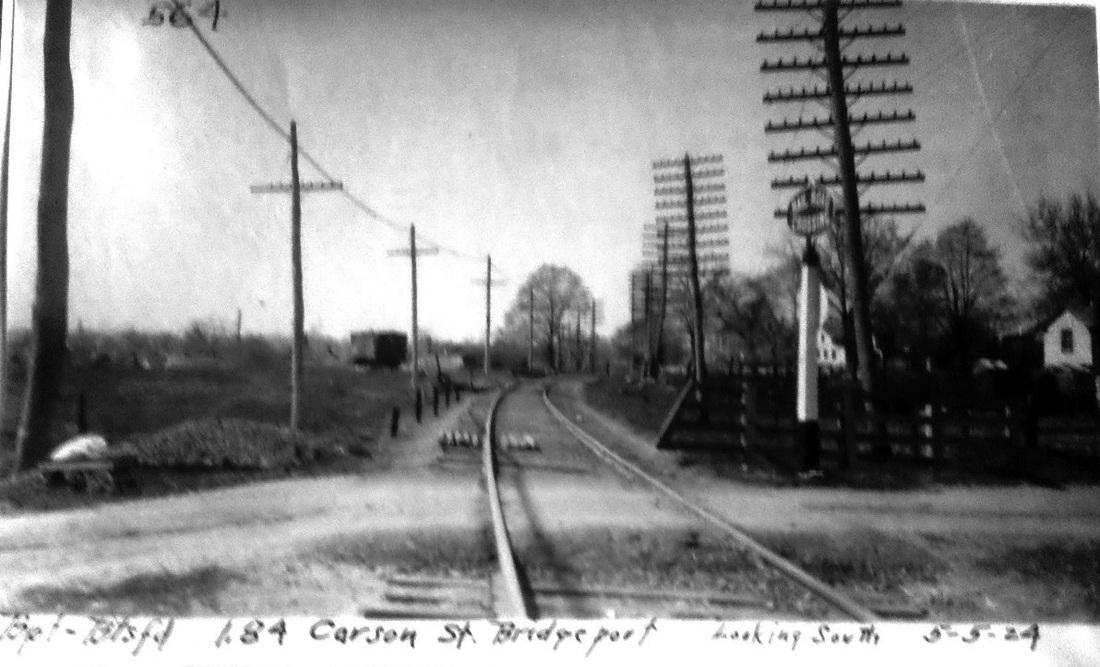
The station appears to have begun in 1866 as PEQUONNOCK, a manufacturing enclave along its namesake river and Bunnell Pond, north of the downtown area. A year later the HRR received permission to discontinue it for lack of patronage, but sometime before 1873 it resurfaces in the same place or nearby, the Palladium saying that "the Housatonic Railroad company are building a cattle depot about fifty rods this side [south] of the station at North Bridgeport." Other newspaper articles also mention the stop and one in 1895 says an injured person was brought inside the depot, a structure for which we yet have no photo. The first HRR document we have showing this stop is the 1883 fare schedule at [1]. A terse 1888 mention in the Newtown Bee says "The shed used as a station has been painted dark brown; an improvement." The location of this diminutive structure is seen in the southwest quadrant of the Carson St. grade crossing on the 1867 Beers and 1893 Hurd maps at [2] and [3]. It carried through to the NYNH&H era and Lee Beaujon says his last passenger timetable to show it is 5/9/1901, though it does still appear on official lists into the 1920s. Perhaps a later incarnation was as a freight stop called LYON, as seen on a 5/5/1924 PUC photo in our collection. Even in the 1950s Bridgeport Sunday Herald columnist Joe Hurley was reminiscing, however vaguely time-wise, about the cattle pen north of Reservoir Ave. and about the 'good old days' of taking the train downtown, making one wonder if riders may still have boarded at NORTH BRIDGEPORT through some local arrangement. By the time the 1911 real estate map [4] was drawn, however, no station is seen here. The PUC shot at [5] looks south at the Carson St. crossing where the station once stood at left; perhaps that mound is the remnant of the 'shed.' The snippet from our Track 11 Google Earth map [6] shows where the stop was located along today's Rtes 8/25 just south of the Chopsey Hill Rd. overpass. With gas rail cars doing the declining honors from 1925 on, passenger service on this part of the old HRR came to a complete end early in 1932 and trackage abandonment from here to the Monroe town line came in 1940. [REFS: RRC5.27 (6/30/1866); RRC5.255 (12/20/1867); NHDP/04/30/1873/04; HDC/09/19/1873/04; CR/11/28/1874/01; HDC/06/24/1875/04; BEF/05/13/1886/00; NBE/06/01/1888/04; NHER/03/30/1889/01; CRC41.1893.293; NYH/12/31/1895/11; HC/03/10/1935/14; HC/11/13/1939/14; BT/12/22/1919/31; BT/02/26/1925/00; BP/04/08/1925/01; PUC Dkt#4619 (11/28/1925); Pkwy bridge: HC/12/29/1935/00; HC/10/29/1939/C10; BSH/02/05/1956/14; K55; NL19.8.10][rev122717, 121518]
The station appears to have begun in 1866 as PEQUONNOCK, a manufacturing enclave along its namesake river and Bunnell Pond, north of the downtown area. A year later the HRR received permission to discontinue it for lack of patronage, but sometime before 1873 it resurfaces in the same place or nearby, the Palladium saying that "the Housatonic Railroad company are building a cattle depot about fifty rods this side [south] of the station at North Bridgeport." Other newspaper articles also mention the stop and one in 1895 says an injured person was brought inside the depot, a structure for which we yet have no photo. The first HRR document we have showing this stop is the 1883 fare schedule at [1]. A terse 1888 mention in the Newtown Bee says "The shed used as a station has been painted dark brown; an improvement." The location of this diminutive structure is seen in the southwest quadrant of the Carson St. grade crossing on the 1867 Beers and 1893 Hurd maps at [2] and [3]. It carried through to the NYNH&H era and Lee Beaujon says his last passenger timetable to show it is 5/9/1901, though it does still appear on official lists into the 1920s. Perhaps a later incarnation was as a freight stop called LYON, as seen on a 5/5/1924 PUC photo in our collection. Even in the 1950s Bridgeport Sunday Herald columnist Joe Hurley was reminiscing, however vaguely time-wise, about the cattle pen north of Reservoir Ave. and about the 'good old days' of taking the train downtown, making one wonder if riders may still have boarded at NORTH BRIDGEPORT through some local arrangement. By the time the 1911 real estate map [4] was drawn, however, no station is seen here. The PUC shot at [5] looks south at the Carson St. crossing where the station once stood at left; perhaps that mound is the remnant of the 'shed.' The snippet from our Track 11 Google Earth map [6] shows where the stop was located along today's Rtes 8/25 just south of the Chopsey Hill Rd. overpass. With gas rail cars doing the declining honors from 1925 on, passenger service on this part of the old HRR came to a complete end early in 1932 and trackage abandonment from here to the Monroe town line came in 1940. [REFS: RRC5.27 (6/30/1866); RRC5.255 (12/20/1867); NHDP/04/30/1873/04; HDC/09/19/1873/04; CR/11/28/1874/01; HDC/06/24/1875/04; BEF/05/13/1886/00; NBE/06/01/1888/04; NHER/03/30/1889/01; CRC41.1893.293; NYH/12/31/1895/11; HC/03/10/1935/14; HC/11/13/1939/14; BT/12/22/1919/31; BT/02/26/1925/00; BP/04/08/1925/01; PUC Dkt#4619 (11/28/1925); Pkwy bridge: HC/12/29/1935/00; HC/10/29/1939/C10; BSH/02/05/1956/14; K55; NL19.8.10][rev122717, 121518]

Robert T. Eastwood Collection
NORTH CROMWELL [CV, c1880?]
This was not an original stop in the town of CROMWELL when the CV opened in 1871 and we need to check timetables further to determine when it first appears. That is Irving Drake walking the rail and mugging it up for photographer Lewis H. Benton. The pair perambulated through New England in the late 1920s and early 1930s taking pictures of railroad stations. This station was "to be repaired and retained" on the 3/15/1939 addendum to the 1938 SSRR list. [REFS: HDC/08/25/1871/02; SL22.4.29][rev010318]
This was not an original stop in the town of CROMWELL when the CV opened in 1871 and we need to check timetables further to determine when it first appears. That is Irving Drake walking the rail and mugging it up for photographer Lewis H. Benton. The pair perambulated through New England in the late 1920s and early 1930s taking pictures of railroad stations. This station was "to be repaired and retained" on the 3/15/1939 addendum to the 1938 SSRR list. [REFS: HDC/08/25/1871/02; SL22.4.29][rev010318]
NORTH FRANKLIN [> LEBANON]

|

|
|
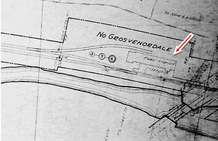
NORTH GROSVENORDALE1 [N&W, 1840; opens as FISHERVILLE]
This stop in the town of THOMPSON began as FISHERVILLE, as it is listed on our 1851TT at left and seen on the 1856WC map at middle. Whether this stop goes back to 1840 is unclear because we have no earlier timetables. By the 1869 map at right, the area is called NORTH GROSVENORDALE and the station likely was renamed as well. This probably came in 1868 when Dr. William Grosvenor merged the Fisherville and Masonville Mill Cos. into one concern bearing his name. Although we think the depot seen our next entry is too substantial to have been the first one here, we have seen no photo yet of the earlier one that we assume stood here. [REFS: HDC/06/01/1860/02][rev070513]
This stop in the town of THOMPSON began as FISHERVILLE, as it is listed on our 1851TT at left and seen on the 1856WC map at middle. Whether this stop goes back to 1840 is unclear because we have no earlier timetables. By the 1869 map at right, the area is called NORTH GROSVENORDALE and the station likely was renamed as well. This probably came in 1868 when Dr. William Grosvenor merged the Fisherville and Masonville Mill Cos. into one concern bearing his name. Although we think the depot seen our next entry is too substantial to have been the first one here, we have seen no photo yet of the earlier one that we assume stood here. [REFS: HDC/06/01/1860/02][rev070513]
Thompson Historical Society
|
|
|

|
|

|
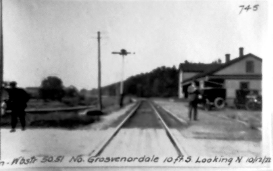
NORTH GROSVENORDALE2 [N&W, 1870?]
The station seen in these photos is quite substantial and probably was not built in the 1840s or 1850s and hence, pending further research and revision, we have listed it as the second one at this stop. The view at upper left is from an 1887 sketch probably done by our old friend, Oakley Hoopes Bailey, who produced many of the bird's-eye maps that we rely on for accurate representations of stations and other structures. He has captured the salient details, including the gabled roof and the two-story storage building at the north end of the station. The card at upper middle is postmarked 1907. The 1915 val map at upper right shows the layout of the station grounds at that time and the val photo at lower left is a shot of the depot on 4/4/1917. In the northward view at lower middle, the PUC is inspecting the crossing on 10/12/1922. Captioning found elsewhere for the photo at lower right says that the train is the southbound East Wind, which has just met its northbound counterpart, on 6/29/1941. The locomotive may be the #1392. A 1953 newspaper article referred an accident happening "near the old North Grosvenordale station" so it may have been still standing at that time. [REFS: HDC/06/01/1860/02; HC/03/09/1953/01][rev121713]
The station seen in these photos is quite substantial and probably was not built in the 1840s or 1850s and hence, pending further research and revision, we have listed it as the second one at this stop. The view at upper left is from an 1887 sketch probably done by our old friend, Oakley Hoopes Bailey, who produced many of the bird's-eye maps that we rely on for accurate representations of stations and other structures. He has captured the salient details, including the gabled roof and the two-story storage building at the north end of the station. The card at upper middle is postmarked 1907. The 1915 val map at upper right shows the layout of the station grounds at that time and the val photo at lower left is a shot of the depot on 4/4/1917. In the northward view at lower middle, the PUC is inspecting the crossing on 10/12/1922. Captioning found elsewhere for the photo at lower right says that the train is the southbound East Wind, which has just met its northbound counterpart, on 6/29/1941. The locomotive may be the #1392. A 1953 newspaper article referred an accident happening "near the old North Grosvenordale station" so it may have been still standing at that time. [REFS: HDC/06/01/1860/02; HC/03/09/1953/01][rev121713]

North Haven Historical Society
|

|

|
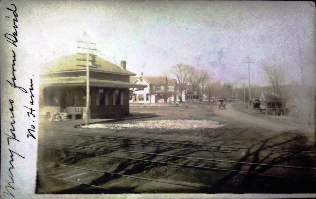
NORTH HAVEN1 [H&NH, 1838]
This stop was established when the H&NH first opened from New Haven to Meriden in 1838. A room in the private home, seen in the distance in the view at left and behind the locomotive in the photograph at middle, reportedly served as the first depot and its location corresponds to that shown on the 1852NH map at right. This building, still standing in photos into the 1930s, was apparently superceded by NORTH HAVEN2 at some point before 1865. [rev032913]
This stop was established when the H&NH first opened from New Haven to Meriden in 1838. A room in the private home, seen in the distance in the view at left and behind the locomotive in the photograph at middle, reportedly served as the first depot and its location corresponds to that shown on the 1852NH map at right. This building, still standing in photos into the 1930s, was apparently superceded by NORTH HAVEN2 at some point before 1865. [rev032913]
NORTH HAVEN2 [H&NH, c1850?]
This image is only here to indicate the site of the next station at this stop. The 1867 H&NH annual report says that "a neat and commodious passenger building has been erected at North Haven Station upon the ground previously occupied by a building belonging to other parties, recently burned, in which the Company had rented rooms for the accomodation of passengers." The description seems to fit NORTH HAVEN1 but that building is seen in later photos so presumably did not burn and the 1867 station, renumbered as NORTH HAVEN4, was built on the on the other (west) side of the track where it still stands today. When it was moved is unclear, but the Columbian Register reported on 4/8/1865 that "the building occupied by the Post Office, Adams Express, Railroad Station, and the grocery store of George W. Stiles... was destroyed by fire about 8:00 this morning." While the Courant somehow managed to scoop the local paper and ascertain that the event really took place on 3/31/1865, the reports are similar. We assume that this multi-function commercial establishment looked similar to the general store seen in the distance, a structure which may possibly have served as the station from 1865 to 1867 after this one burned. [REFS: CR/06/18/1864/03; HDC/04/01/1865/03; CR/04/08/1865/03; R78][rev090213]
This image is only here to indicate the site of the next station at this stop. The 1867 H&NH annual report says that "a neat and commodious passenger building has been erected at North Haven Station upon the ground previously occupied by a building belonging to other parties, recently burned, in which the Company had rented rooms for the accomodation of passengers." The description seems to fit NORTH HAVEN1 but that building is seen in later photos so presumably did not burn and the 1867 station, renumbered as NORTH HAVEN4, was built on the on the other (west) side of the track where it still stands today. When it was moved is unclear, but the Columbian Register reported on 4/8/1865 that "the building occupied by the Post Office, Adams Express, Railroad Station, and the grocery store of George W. Stiles... was destroyed by fire about 8:00 this morning." While the Courant somehow managed to scoop the local paper and ascertain that the event really took place on 3/31/1865, the reports are similar. We assume that this multi-function commercial establishment looked similar to the general store seen in the distance, a structure which may possibly have served as the station from 1865 to 1867 after this one burned. [REFS: CR/06/18/1864/03; HDC/04/01/1865/03; CR/04/08/1865/03; R78][rev090213]

NORTH HAVEN3 [H&NH, 1865]
The store in this close-up of a 1930s Benton and Drake image [#2830] -- the touring car is front and center -- is also said to have served as a depot at one time. If the "recently burned" structure in the 1867 annual report does not correspond with the one destroyed two years earlier on 3/31/1865, as we are inclined to think, then this likely served as the station until NORTH HAVEN4 was built. The annual reports for 1865 and 1866, to which we do not seem to have access, would possibly clear this up but this is the best we can do until then. [rev090213]
The store in this close-up of a 1930s Benton and Drake image [#2830] -- the touring car is front and center -- is also said to have served as a depot at one time. If the "recently burned" structure in the 1867 annual report does not correspond with the one destroyed two years earlier on 3/31/1865, as we are inclined to think, then this likely served as the station until NORTH HAVEN4 was built. The annual reports for 1865 and 1866, to which we do not seem to have access, would possibly clear this up but this is the best we can do until then. [rev090213]
North Haven Historical Society
|
|
Joe Taylor Collection
|
|
|
|
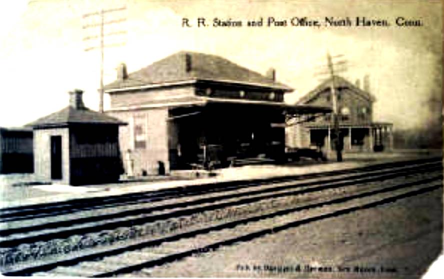
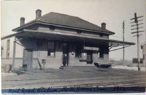
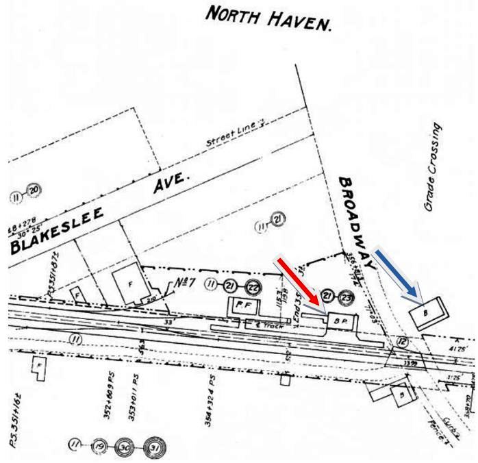
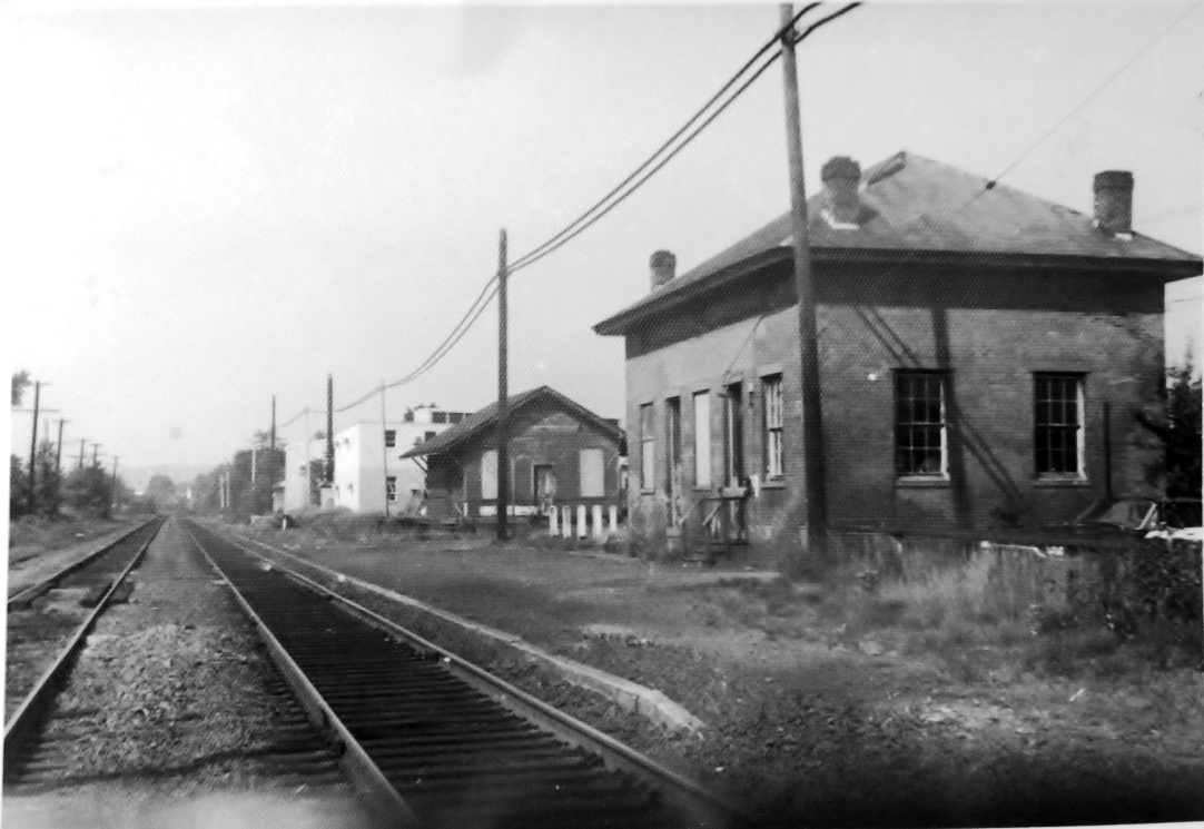
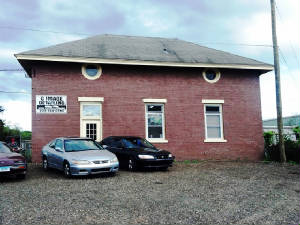
NORTH HAVEN4 [H&NH, 1867]
The 1912 photo at upper left shows off this elegant, Italianate brick depot ornamented with chimneys in each of the four corners. An article we chanced upon in the Norwich Aurora has finally given us a build date of February, 1867 for this station, saying that "The New Haven, Hartford and Springfield Railroad Co. have erected a new and tasty depot at North Haven." An 1883 Register article credits William P. Dickerman, who completed a number of projects for the NYNH&H over the years, as the builder. The 1868 map at upper middle corroborates the change in location, showing the depot now on the west side of the track. The card at upper right, postmarked 1904, looks west. The 1915 val map at lower left shows the arrangement of facilities at that time. The shot at lower middle dates to 1960 and looks south with the freight house, still extant in 2013, in the distance. NORTH HAVEN4, bereft of its awnings and apparently turned 90 degrees, is seen at lower right, today in commercial use. This view looks south, with the Hartford line tracks just out of sight to the left. [REFS: HNHAR32.1867.8; NA/02/13/1867/04 NHER/11/21/1883/01; R78: 1860][rev09 0213]
The 1912 photo at upper left shows off this elegant, Italianate brick depot ornamented with chimneys in each of the four corners. An article we chanced upon in the Norwich Aurora has finally given us a build date of February, 1867 for this station, saying that "The New Haven, Hartford and Springfield Railroad Co. have erected a new and tasty depot at North Haven." An 1883 Register article credits William P. Dickerman, who completed a number of projects for the NYNH&H over the years, as the builder. The 1868 map at upper middle corroborates the change in location, showing the depot now on the west side of the track. The card at upper right, postmarked 1904, looks west. The 1915 val map at lower left shows the arrangement of facilities at that time. The shot at lower middle dates to 1960 and looks south with the freight house, still extant in 2013, in the distance. NORTH HAVEN4, bereft of its awnings and apparently turned 90 degrees, is seen at lower right, today in commercial use. This view looks south, with the Hartford line tracks just out of sight to the left. [REFS: HNHAR32.1867.8; NA/02/13/1867/04 NHER/11/21/1883/01; R78: 1860][rev09 0213]

|

|
|
|
|
|
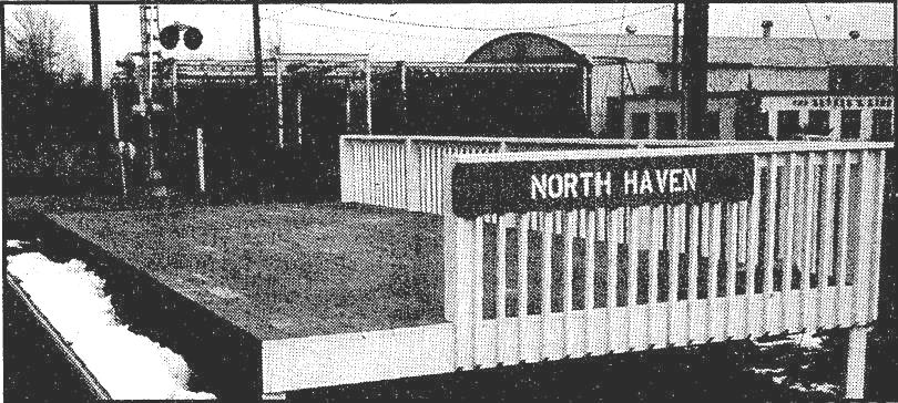
NORTH HAVEN5 [ATK, 1980]
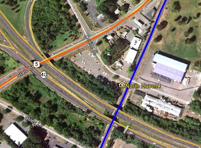
This was a former Amtrak stop on Devine St. in North Haven with CT Rte. 40 passing behind. In the upper row, the photo at left looks southwest and the others look northeast. We took the newer photos on 3/11/2012 and they validate the location. According to an article in Meriden's Record-Journal, service began on 10/26/1980. The New York Times even picked up on the news, saying that passengers could board or detrain here for the first time since the early 1970s and use a 100-car parking lot that the DOT had provided. The CTTRAXMAP snippet at lower right shows the location on a current map. It was further noted that Connecticut's purchase of new Budd SPV railcars made the extra trains possible, with 13 runs each way daily and nine on weekends. Service ended here, as well as at ENFIELD, on 10/25/1986 because of low ridership, according to an article in the Courant. As far back as 2004, both towns were looking to reinstitute their stops and this is now, in 2012, part of a new state plan to upgrade the Springfield line. [REFS: HC/10/18/1980/A9; MRJ/10/18/1980/03; NYT/11/30/1980/CN3; HC/08/27/1981/A1; HC/10/02/1986/C6; HC/12/19/2004/ A1; HC/01/16/2012/B1; NL8.1.5][rev101112]
This was a former Amtrak stop on Devine St. in North Haven with CT Rte. 40 passing behind. In the upper row, the photo at left looks southwest and the others look northeast. We took the newer photos on 3/11/2012 and they validate the location. According to an article in Meriden's Record-Journal, service began on 10/26/1980. The New York Times even picked up on the news, saying that passengers could board or detrain here for the first time since the early 1970s and use a 100-car parking lot that the DOT had provided. The CTTRAXMAP snippet at lower right shows the location on a current map. It was further noted that Connecticut's purchase of new Budd SPV railcars made the extra trains possible, with 13 runs each way daily and nine on weekends. Service ended here, as well as at ENFIELD, on 10/25/1986 because of low ridership, according to an article in the Courant. As far back as 2004, both towns were looking to reinstitute their stops and this is now, in 2012, part of a new state plan to upgrade the Springfield line. [REFS: HC/10/18/1980/A9; MRJ/10/18/1980/03; NYT/11/30/1980/CN3; HC/08/27/1981/A1; HC/10/02/1986/C6; HC/12/19/2004/ A1; HC/01/16/2012/B1; NL8.1.5][rev101112]

|

|
|
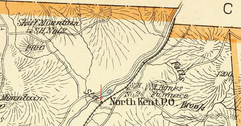
NORTH KENT1 [HRR, 1880]
Also known as KENT FURNACE. While never seen at all on the RRMs or as a railroad station in the GHDs, this stop first appears on timetables around 1880.
Also known as KENT FURNACE. While never seen at all on the RRMs or as a railroad station in the GHDs, this stop first appears on timetables around 1880.
Max Miller Collection
|
|
Dave Peters Collection
|
|
NORTH KENT2 [NYNH&H, c1900]
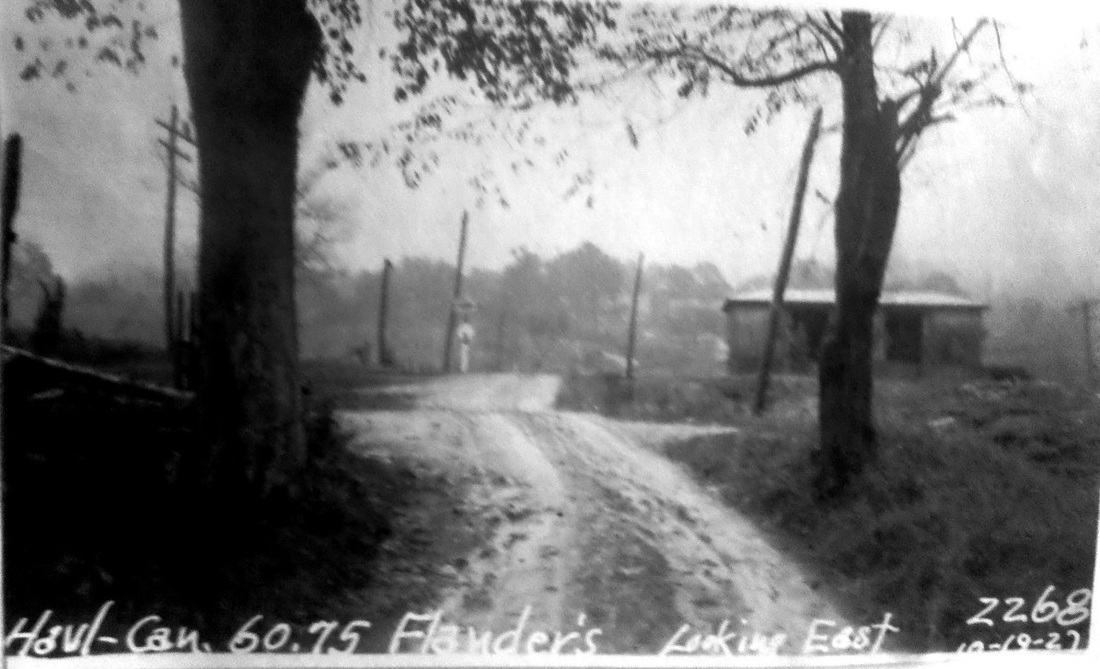
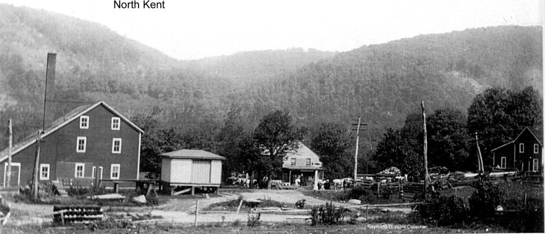
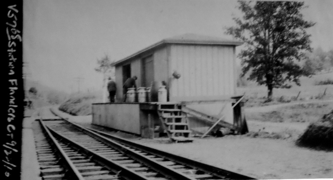
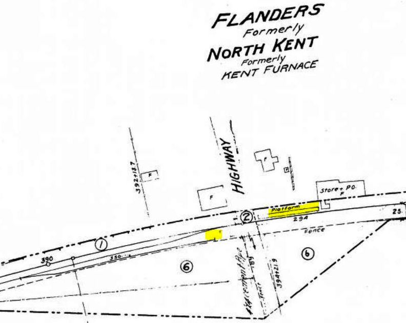
The structure in the 1916 val photo [lower left] is a milk depot but was probably also used for passengers, as was done at BOARDMANS BRIDGE, ROXBURY FALLS, WHITING RIVER, and elsewhere in Litchfield County dairy country. The PUC photo at upper left is an eastward looking view on 10/19/1927. The original passenger depot is the store and post office in the middle distance in the shot at upper right, with the milk station seen in the center. The val photo at lower right is dated 9/22/1916. The 1915 val map at lower right shows the location highlighted in yellow, though the footprint of the milk depot is not on the map for some reason. The title shows the evolution of the name of the stop here. It was renamed FLANDERS after an accident of 6/2/1913 when a southbound special did not take the siding as instructed and plowed into northbound milk train waiting for the special pass. Engineer Rigby of the special was indicted for manslaughter in the death of his fireman but was acquitted by a jury on the criminal charge. The PUC investigation said that the multiple KENT station names may have played a role in the mishap. SOUTH KENT was also changed to LILY LAKE and then to WOODROW as a result of the same incident. An earlier accident here on 3/30/1905 resulted in serious injury to Engineer Phil Blakeslee, author of Lines West, who was under his locomotive trying to make repairs. FLANDERS is on our 1923TT as such and is gone by our 1937TT. [REFS: CRC36.1888.29; HC/03/31/1905/01; HC/06/04/1913/15; HC/07/09/1913/17; HC/07/18/1913/02; HC/11/06/1913/15; D74]
The structure in the 1916 val photo [lower left] is a milk depot but was probably also used for passengers, as was done at BOARDMANS BRIDGE, ROXBURY FALLS, WHITING RIVER, and elsewhere in Litchfield County dairy country. The PUC photo at upper left is an eastward looking view on 10/19/1927. The original passenger depot is the store and post office in the middle distance in the shot at upper right, with the milk station seen in the center. The val photo at lower right is dated 9/22/1916. The 1915 val map at lower right shows the location highlighted in yellow, though the footprint of the milk depot is not on the map for some reason. The title shows the evolution of the name of the stop here. It was renamed FLANDERS after an accident of 6/2/1913 when a southbound special did not take the siding as instructed and plowed into northbound milk train waiting for the special pass. Engineer Rigby of the special was indicted for manslaughter in the death of his fireman but was acquitted by a jury on the criminal charge. The PUC investigation said that the multiple KENT station names may have played a role in the mishap. SOUTH KENT was also changed to LILY LAKE and then to WOODROW as a result of the same incident. An earlier accident here on 3/30/1905 resulted in serious injury to Engineer Phil Blakeslee, author of Lines West, who was under his locomotive trying to make repairs. FLANDERS is on our 1923TT as such and is gone by our 1937TT. [REFS: CRC36.1888.29; HC/03/31/1905/01; HC/06/04/1913/15; HC/07/09/1913/17; HC/07/18/1913/02; HC/11/06/1913/15; D74]
NORTH MIDDLETOWN
Possibly NEWFIELD?
NORTH NEWTOWN [> NEWTOWN/N]
NORTH WESTCHESTER
[RAM1908: AMSTON?]
Possibly NEWFIELD?
NORTH NEWTOWN [> NEWTOWN/N]
NORTH WESTCHESTER
[RAM1908: AMSTON?]
Dave Peters Collection
|

Dave Peters Collection
|
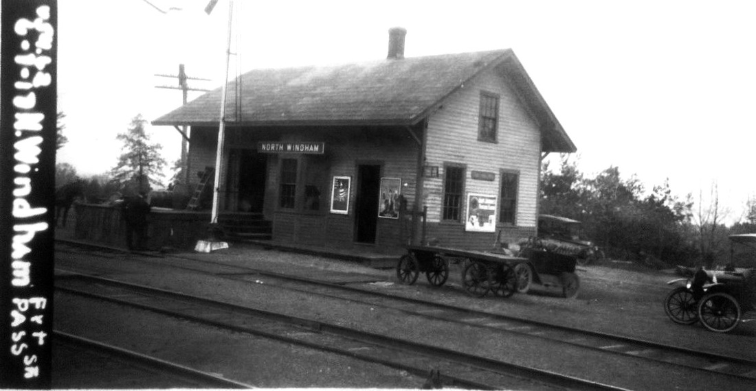
NORTH WINDHAM [BH&E, 1872]
|

|
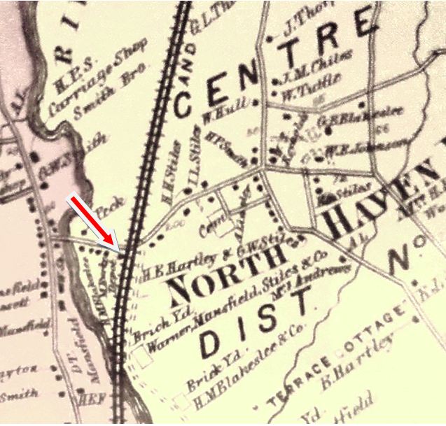
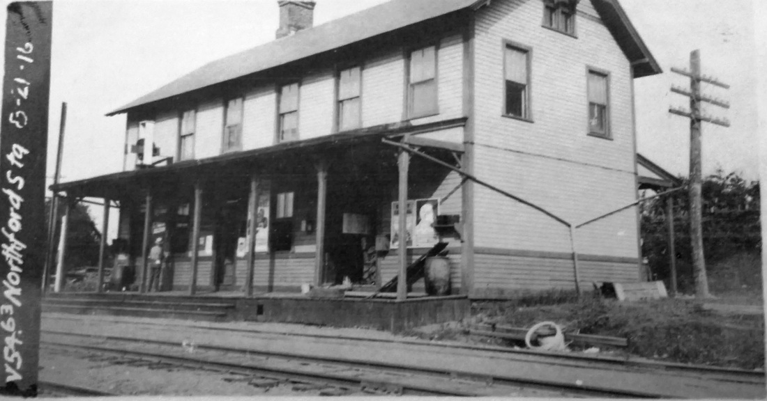
NORTHFORD1 [NHM&W, 1870]
This stop in NORTH HAVEN was established in 1870 by the NHM&W. The Register said in August that railroad president David Lyman "has located the depot at upper North Haven, on the road leading from North Haven to Northfield [sic], and will call the station Clintonville." The 1871 timetable at left calls this stop NORTHFORD, and with one minor exception, that is the only name we have ever seen for it. This is in spite of the fact that the village of Clintonville is closer than Northford, as shown on the 1892 topo map at right. Contrary to the newspaper's supposition, its own text gives the reason when the article further states that "for establishing this station, the manufacturers of Northford have agreed to ship 1500 tons of freight via the Air Line." We are not sure how common these policies were but this is an interesting insight into the way that railroads decided where they were going to stop and what they were going to call those stops: whoever paid the freight! This station burned on 10/18/1883. The Register reported as follows: "The Northford station of the Air Line railroad was completely destroyed by fire yesterday afternoon. The building was an old one and burned down very rapidly. George W. Talmadge, the station agent, who occupied the second floor of the building, sustained the greatest loss, all his furniture and a number of small printing presses, which she stored there, being destroyed. Mr. Talmadge’s goods were insured with Benjamin Page of Meriden for $800." Described as 'old' 12 years after the railroad opened, it sounds as though this two-story structure was not purpose-built as a station. We have no photo as of yet. [REFS: CR/08/06/1870/02; CR/01/24/1874/03; CR/11/14/1874/02; HDC/10/19/1883/04; NHER/10/19/1883/02; PTH390.1871.20; RRC12.83 (6/25/1880); RAM1908 says Clintonville][rev072017]
This stop in NORTH HAVEN was established in 1870 by the NHM&W. The Register said in August that railroad president David Lyman "has located the depot at upper North Haven, on the road leading from North Haven to Northfield [sic], and will call the station Clintonville." The 1871 timetable at left calls this stop NORTHFORD, and with one minor exception, that is the only name we have ever seen for it. This is in spite of the fact that the village of Clintonville is closer than Northford, as shown on the 1892 topo map at right. Contrary to the newspaper's supposition, its own text gives the reason when the article further states that "for establishing this station, the manufacturers of Northford have agreed to ship 1500 tons of freight via the Air Line." We are not sure how common these policies were but this is an interesting insight into the way that railroads decided where they were going to stop and what they were going to call those stops: whoever paid the freight! This station burned on 10/18/1883. The Register reported as follows: "The Northford station of the Air Line railroad was completely destroyed by fire yesterday afternoon. The building was an old one and burned down very rapidly. George W. Talmadge, the station agent, who occupied the second floor of the building, sustained the greatest loss, all his furniture and a number of small printing presses, which she stored there, being destroyed. Mr. Talmadge’s goods were insured with Benjamin Page of Meriden for $800." Described as 'old' 12 years after the railroad opened, it sounds as though this two-story structure was not purpose-built as a station. We have no photo as of yet. [REFS: CR/08/06/1870/02; CR/01/24/1874/03; CR/11/14/1874/02; HDC/10/19/1883/04; NHER/10/19/1883/02; PTH390.1871.20; RRC12.83 (6/25/1880); RAM1908 says Clintonville][rev072017]
|
|
|
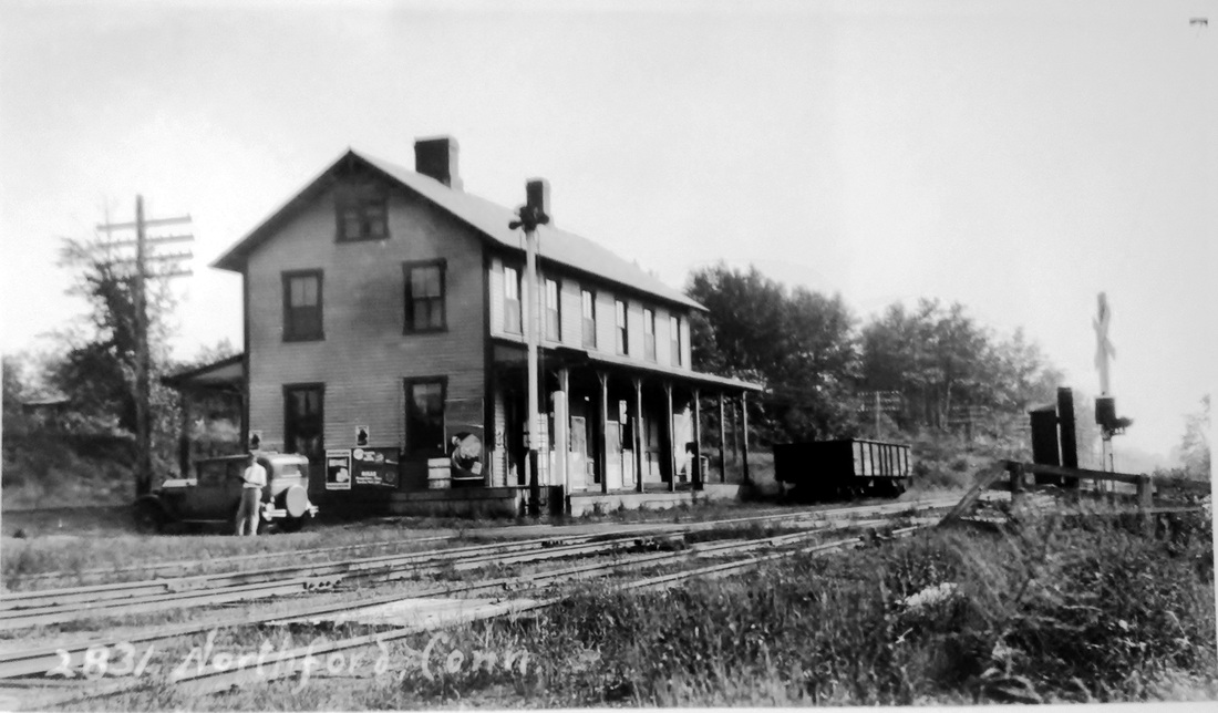
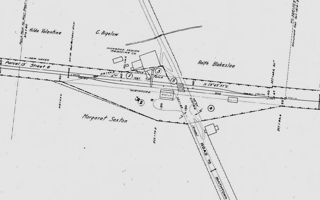
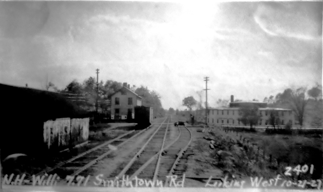
NORTHFORD2 [NYNH&H, 1883]
A month after the old depot burned, the Register announced that contractor and builder William P. Dickerman of the Elm City would be putting up the new one, saying that "though not a large structure, the new building will be a handsome one and a model of its kind... patterned after the one recently erected at Stony Creek on the Shore Line road." Completion was expected by December 1. With the NYNH&H having leased the Air Line in 1882, it is no wonder that a contractor who did work for them in the past would be selected for the job here. STONY CREEK2, which opened earlier in 1883 does look similar though it is only one story. The article goes on to also credit Dickerman for NEW HAVEN4, NORTH HAVEN3, SAYBROOK3, and a "large addition" in the works for STRATFORD2. The val photo at [1] is dated 8/21/1916 and the 1915 val map at [2] shows the station area at that time. The PUC inspection shot at [3] looks railroad-west toward New Haven on 10/21/1927 and shows the depot in the compass-southeast quadrant of the grade crossing. The image at [4] is Lewis H. Benton #2831 taken in 1931, likely on September 6th. Irving N. Drake, affecting nonchalance with a magazine, is seen at left with his automobile, transportation for the duo in their photographic adventures. The 1938 SSRR says this station, partly rented at the time, was sold on 7/20/1938 to Middletown Wrecking Co. [REFS: NHER/11/21/1883/01; NHER/03/17/1886/03][rev010318]
A month after the old depot burned, the Register announced that contractor and builder William P. Dickerman of the Elm City would be putting up the new one, saying that "though not a large structure, the new building will be a handsome one and a model of its kind... patterned after the one recently erected at Stony Creek on the Shore Line road." Completion was expected by December 1. With the NYNH&H having leased the Air Line in 1882, it is no wonder that a contractor who did work for them in the past would be selected for the job here. STONY CREEK2, which opened earlier in 1883 does look similar though it is only one story. The article goes on to also credit Dickerman for NEW HAVEN4, NORTH HAVEN3, SAYBROOK3, and a "large addition" in the works for STRATFORD2. The val photo at [1] is dated 8/21/1916 and the 1915 val map at [2] shows the station area at that time. The PUC inspection shot at [3] looks railroad-west toward New Haven on 10/21/1927 and shows the depot in the compass-southeast quadrant of the grade crossing. The image at [4] is Lewis H. Benton #2831 taken in 1931, likely on September 6th. Irving N. Drake, affecting nonchalance with a magazine, is seen at left with his automobile, transportation for the duo in their photographic adventures. The 1938 SSRR says this station, partly rented at the time, was sold on 7/20/1938 to Middletown Wrecking Co. [REFS: NHER/11/21/1883/01; NHER/03/17/1886/03][rev010318]

|

|
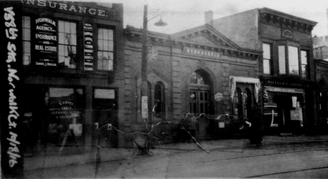
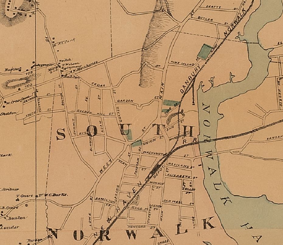
NORWALK/D1 [D&N, 1852]
This depot was above the tracks on Wall St. at the blue arrow. Peter Cornwall says that a "novel station at Norwalk was built 'over the tracks... like the one at New Rochelle' adjacent to Wall Street where the track went through a deep cut which is today a man-made tunnel." According to the Danbury Times ad, this station also had boat service. The green arrow points to docks that passengers may have used on the adjacent Norwalk River. This 'spring board' station, as described in the next entry, was destroyed in a fire that took much of the downtown and was replaced by NORWALK/D2 in 1859. In material apparently quoted in the NHRHTA newsletter from the May, 1925 issue of Along the Line, the tunnel was through rock that was "so hard and tenacious that it broke the contractor." The yellow arrow points to the D&N steamboat dock: see NORWALK4, below. [REFS: CC/11/19/1858/02; SL16.4.26; NL6.8.6]
This depot was above the tracks on Wall St. at the blue arrow. Peter Cornwall says that a "novel station at Norwalk was built 'over the tracks... like the one at New Rochelle' adjacent to Wall Street where the track went through a deep cut which is today a man-made tunnel." According to the Danbury Times ad, this station also had boat service. The green arrow points to docks that passengers may have used on the adjacent Norwalk River. This 'spring board' station, as described in the next entry, was destroyed in a fire that took much of the downtown and was replaced by NORWALK/D2 in 1859. In material apparently quoted in the NHRHTA newsletter from the May, 1925 issue of Along the Line, the tunnel was through rock that was "so hard and tenacious that it broke the contractor." The yellow arrow points to the D&N steamboat dock: see NORWALK4, below. [REFS: CC/11/19/1858/02; SL16.4.26; NL6.8.6]
Dave Peters Collection
|
Norwalk Public Library
|

Norwalk Public Library
|
|

|

|
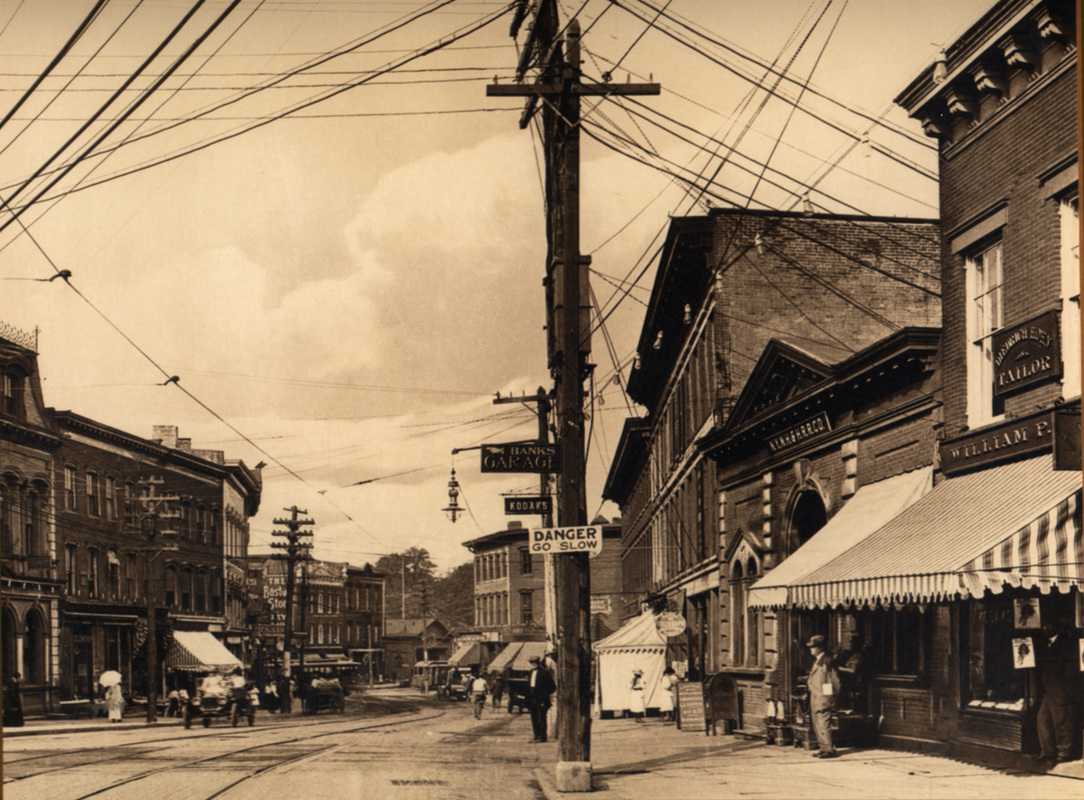
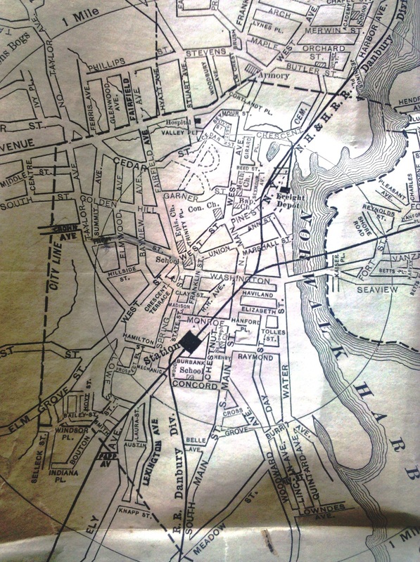
NORWALK/D2 [D&N, 1859]
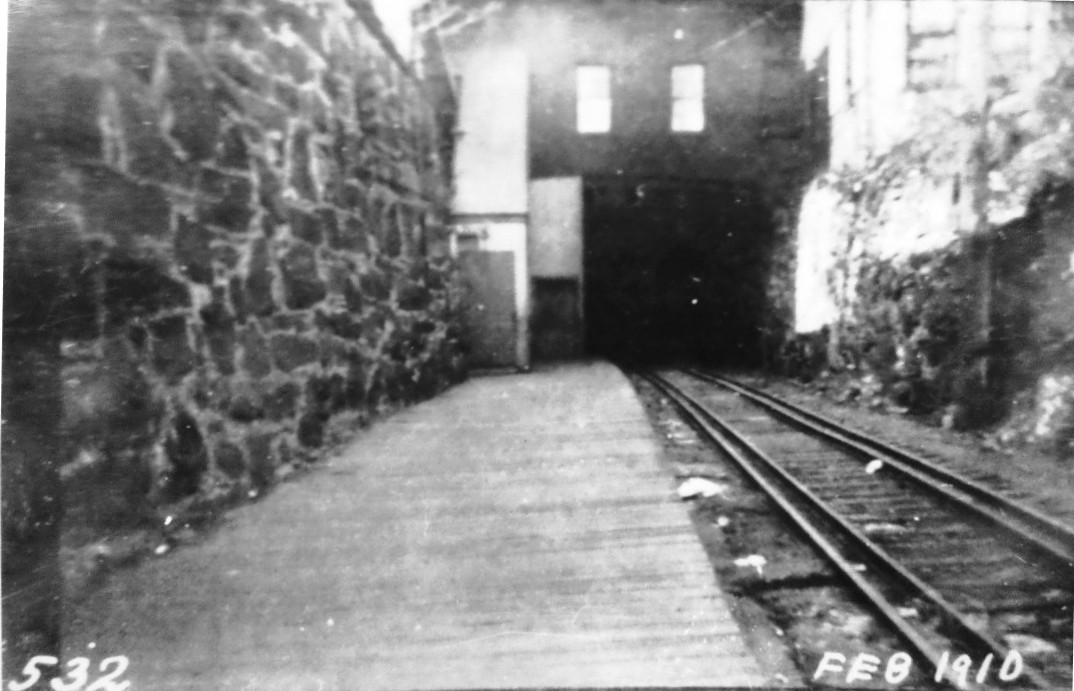
This station was built to replace NORWALK2 and was reported in the Courant to have been almost finished early in July, 1859. Later in the month it said that "a new depot was opened on Monday, July 25, at Norwalk for the accommodation of passengers. The new edifice is neatly and tastefully arranged, and is a great improvement upon the old 'spring board' structure. A great improvement is also made in its stairs, which the ladies will appreciate." It was refurbished in 1870 and the railroad commissioners said in 1881 that the "upper Norwalk" depot had been expanded and its retaining walls strengthened. The 10/17/1916 val photo at [1] shows the front of the station and the 1907 shot at [2] shows a side view of it and the surrounding street scene. The image at [3] is from the 1858 Smith map of Norwalk and clearly shows the depot at our red arrow. The photo at [4] is a 1910 view of the lower level of this station, with the covered stairway on the left leading down to the tracks. The image at [5] from the Landis and Hughes 1899 bird's-eye map of the Norwalks [click here] shows the railroad tunnel under Wall St. The 1915 val map at [6] shows the brick passenger station on Wall St. at the yellow highlight on the left. How long NORWALK3 was used is not clear but it stood until downtown redevelopment in the 1960s. The yellow highlight at right on the val map shows where its successor, NORWALK/D4, would be located. [REFS: HDC/07/08/1859/02; HDC/07/29/1859/02; DT/11/30/1870 /02; CRC31.1881.14][rev080519]
This station was built to replace NORWALK2 and was reported in the Courant to have been almost finished early in July, 1859. Later in the month it said that "a new depot was opened on Monday, July 25, at Norwalk for the accommodation of passengers. The new edifice is neatly and tastefully arranged, and is a great improvement upon the old 'spring board' structure. A great improvement is also made in its stairs, which the ladies will appreciate." It was refurbished in 1870 and the railroad commissioners said in 1881 that the "upper Norwalk" depot had been expanded and its retaining walls strengthened. The 10/17/1916 val photo at [1] shows the front of the station and the 1907 shot at [2] shows a side view of it and the surrounding street scene. The image at [3] is from the 1858 Smith map of Norwalk and clearly shows the depot at our red arrow. The photo at [4] is a 1910 view of the lower level of this station, with the covered stairway on the left leading down to the tracks. The image at [5] from the Landis and Hughes 1899 bird's-eye map of the Norwalks [click here] shows the railroad tunnel under Wall St. The 1915 val map at [6] shows the brick passenger station on Wall St. at the yellow highlight on the left. How long NORWALK3 was used is not clear but it stood until downtown redevelopment in the 1960s. The yellow highlight at right on the val map shows where its successor, NORWALK/D4, would be located. [REFS: HDC/07/08/1859/02; HDC/07/29/1859/02; DT/11/30/1870 /02; CRC31.1881.14][rev080519]
Norwalk Public Library
|
Norwalk Public Library
|
|

NORWALK/D3 [D&N, 1871]
This was the D&N's steamboat wharf and, though hampered by harbor freezes during the winter, a considerable amount of freight was handled here, at least until the Wilson Point warmer-water terminal was opened in 1882. The 50x938-ft long pier and harbor buildings opened in early 1871. We agree with Cornwall that this is not seen as a stop on passenger timetables, but we have found the newspaper ad at [4] that says passenger connections were made here, and that free transfer service was offered from the NYNH&H station. The railroad commissioners mention that the D&N was using horsecars, this on a separate Water St. track, between the Norwalk and South Norwalk stations. Perhaps they fit into the transfer service here. We assume that the earlier boat connections at Wall St. were moved here after 1871, when this extensive facility opened. According to material in NHRHTA newsletter apparently taken from the May, 1925 Along the Line, Legrand Lockwood's 1862 charter for a street railway in Norwalk [click here] that would have competed with the horse line was the reason for the family getting control of the D&N. Once the Lockwoods were in charge in 1864, the railroad service was discontinued and, according to the Courant, the new horse railroad was carrying 1,000 passengers per day. The 1876 [1,2] and 1905 [3] maps show the Dock freight yard that was below NORWALK4 and that was on NYNH&H employee timetables well into the late 20th century and by that time stretched almost all the way down to the main line. [REFS: CRC10.1863.16; NHDP/04/23/1863/02; HDC/04/22/1864/02; DT/11/24/1870/02; DT/04/26/1871 /02; NL6.8.6; SL17.4.23][rev080519]
This was the D&N's steamboat wharf and, though hampered by harbor freezes during the winter, a considerable amount of freight was handled here, at least until the Wilson Point warmer-water terminal was opened in 1882. The 50x938-ft long pier and harbor buildings opened in early 1871. We agree with Cornwall that this is not seen as a stop on passenger timetables, but we have found the newspaper ad at [4] that says passenger connections were made here, and that free transfer service was offered from the NYNH&H station. The railroad commissioners mention that the D&N was using horsecars, this on a separate Water St. track, between the Norwalk and South Norwalk stations. Perhaps they fit into the transfer service here. We assume that the earlier boat connections at Wall St. were moved here after 1871, when this extensive facility opened. According to material in NHRHTA newsletter apparently taken from the May, 1925 Along the Line, Legrand Lockwood's 1862 charter for a street railway in Norwalk [click here] that would have competed with the horse line was the reason for the family getting control of the D&N. Once the Lockwoods were in charge in 1864, the railroad service was discontinued and, according to the Courant, the new horse railroad was carrying 1,000 passengers per day. The 1876 [1,2] and 1905 [3] maps show the Dock freight yard that was below NORWALK4 and that was on NYNH&H employee timetables well into the late 20th century and by that time stretched almost all the way down to the main line. [REFS: CRC10.1863.16; NHDP/04/23/1863/02; HDC/04/22/1864/02; DT/11/24/1870/02; DT/04/26/1871 /02; NL6.8.6; SL17.4.23][rev080519]
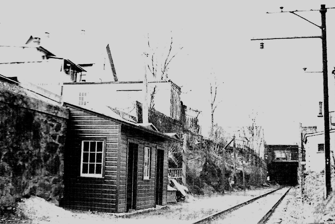
NORWALK/D4 [NYNH&H, c1945]
When this shed replaced the aging NORWALK/D3 as the new Wall St. station, is unclear. This one was actually on Water St., today Commerce St., just south of the tunnel which can be seen in the distance. Cornwall dates this photo to 4/13/1946 after he says the shed was refurbished and he has another showing the structure in a state of disrepair in 1954 and says only minimal train service was provided by then. We do not know when it was completely eliminated but a 10/28/1956 timetable shows just one New York-bound morning train stopping here. The rest of downtown Norwalk service was via the Danbury Bus Corp. stopping at the United Cigar store in the Marshall Bldg. at Main and Wall Sts. The store happened to be purchased by Major Patrick H. Lyden [click here], the NYNH&H's South Norwalk ticket agent who got a 'leave of absence' from the road to anticipate retirement while working at his new post. [REFS: SL17.4.23; SL31.3.13; P102][rev011115]
When this shed replaced the aging NORWALK/D3 as the new Wall St. station, is unclear. This one was actually on Water St., today Commerce St., just south of the tunnel which can be seen in the distance. Cornwall dates this photo to 4/13/1946 after he says the shed was refurbished and he has another showing the structure in a state of disrepair in 1954 and says only minimal train service was provided by then. We do not know when it was completely eliminated but a 10/28/1956 timetable shows just one New York-bound morning train stopping here. The rest of downtown Norwalk service was via the Danbury Bus Corp. stopping at the United Cigar store in the Marshall Bldg. at Main and Wall Sts. The store happened to be purchased by Major Patrick H. Lyden [click here], the NYNH&H's South Norwalk ticket agent who got a 'leave of absence' from the road to anticipate retirement while working at his new post. [REFS: SL17.4.23; SL31.3.13; P102][rev011115]
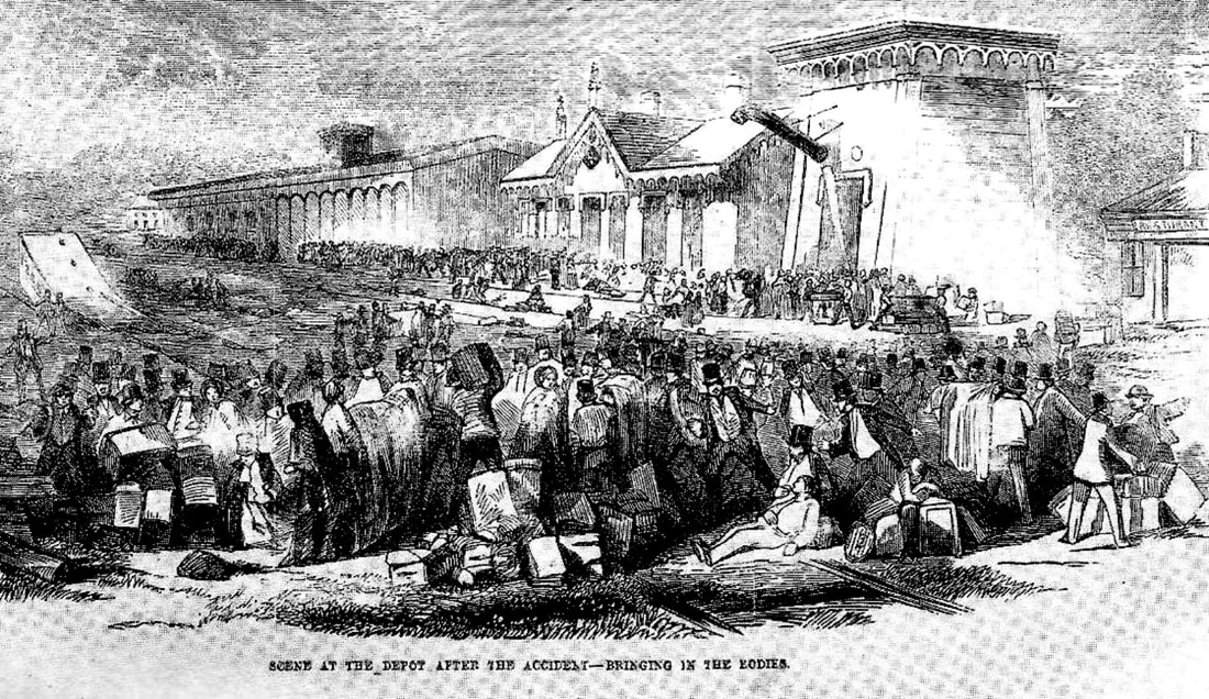
|
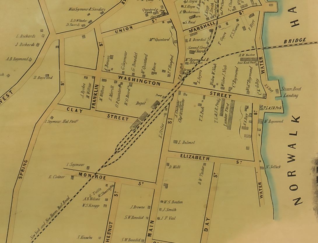
Norwalk Public Library
|
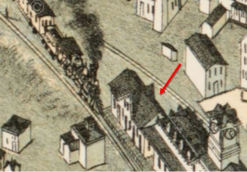
|
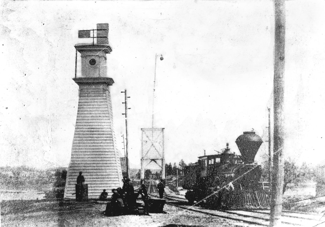
|
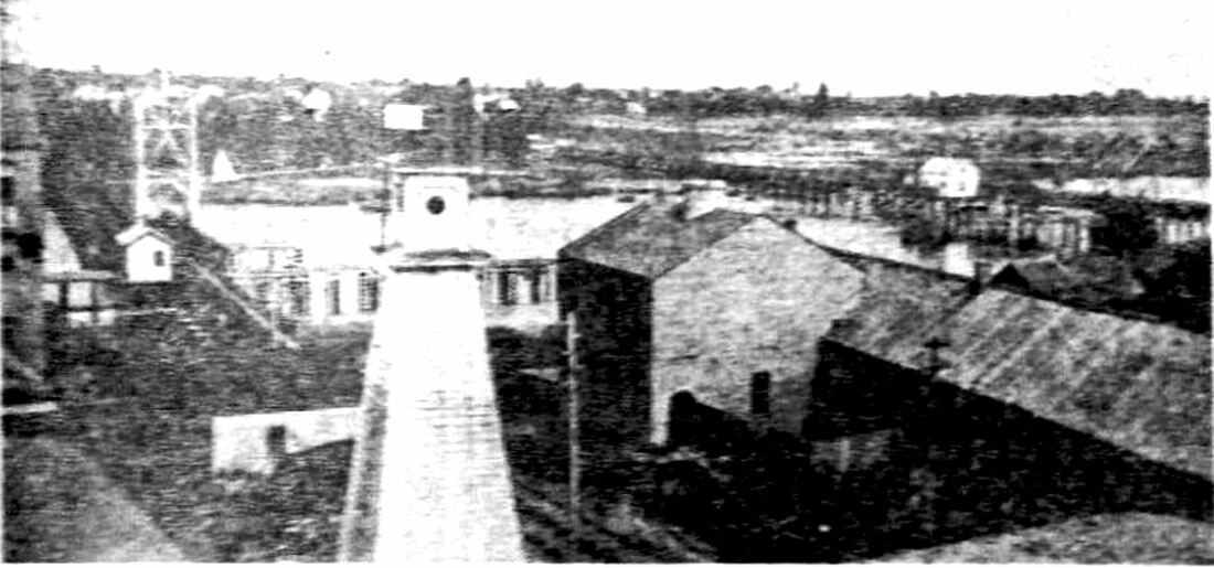
|
NORWALK/N1 [NY&NH, 1848]
This station is seen sitting on the north side of the tracks at [1] in the Illustrated News of 5/14/1853 after the 5/6/1853 Norwalk River drawbridge catastrophe, captioned as "Scene at the Depot After the Accident -- Bringing in the Bodies," after a train plunged off the drawbridge, either the signal being faulty or the crew not seeing it. Forty-six people were killed, many of whom were physicians returning from a convention in New York City. It was the country's worst rail disaster until that time and, according to Karr, still the worst in New England railroad history. The incident was taken seriously by the legislature which appointed three General Railroad Commissioners, later the Board of Railroad Commissioners, perhaps the first such body in any state to monitor the safety of all railroad operations on behalf of the public. Structural details abound in the image, including the cross-gabled Victorian-style wooden passenger depot itself, similar in design to the other early NY&NH stations. A huge structure (freight house?) is seen to its left and the water 'pump' with spout to its right, a structure that appears to overtop the station itself. The building at far right has the barely discernible word 'Restaurant' over the entrance. After the 1852 opening of the D&N, this depot was shared by that railroad as well. The 1851 map at [2] shows the location and even notes the 'Pump' on the east end of the complex. Note that it already shows the D&N which would not open until early 1852. On the 1875 Bailey bird's-eye map at [3], this depot is now seen as a freight house after NORWALK/N2 opened in 1867. The two signal tower photos appeared in The Norwalk Hour issue commemorating the 300th anniversary of the town. The view at [4] is captioned in the newspaper as an 1853 scene and certainly the wood-burning steamer and the single-tracked drawbridge would bear that out. We also see two tracks narrowing to one at the bridge and, according to the newspapers, double-tracking from New Haven to New Rochelle was completed by the beginning of 1853, with the exception of the bridges which were double-tracked later. We speculate that all the towers like this were built in late 1852 at Norwalk, Bridgeport and Naugatuck Jct (Devon), to protect open-draw river crossings where the double tracking narrowed down to single track. Further observation here shows that the lighthouse-like operator's tower controlled a ball signal at the river's edge. Assuming the tower was already in use before the May, 1853 disaster, it did not prevent the accident. The most obvious explanation is that the crew did not see the absence of the ball which was the signal of danger. The shot at [5] says it is from ca. 1870 and the same structures are sill in place. Coincidentally, the first double-tracked bridge at Norwalk was in the works in 1871 and the towers may have come down at that time. The Bailey 1875 bird's-eye map [not shown] has no towers either at the river or where the operator's tower stood east of the station, just beyond where the D&N came in. [REFS: CC/12/18/1852/01; HC/05/07/1853/01; HC/05/10/1853/02; Conn. Public Acts (1853), ch. 74; HDC/07/03/1871/04; NHO/08/07/1951/00; K1-47][rev020319, 080519]
This station is seen sitting on the north side of the tracks at [1] in the Illustrated News of 5/14/1853 after the 5/6/1853 Norwalk River drawbridge catastrophe, captioned as "Scene at the Depot After the Accident -- Bringing in the Bodies," after a train plunged off the drawbridge, either the signal being faulty or the crew not seeing it. Forty-six people were killed, many of whom were physicians returning from a convention in New York City. It was the country's worst rail disaster until that time and, according to Karr, still the worst in New England railroad history. The incident was taken seriously by the legislature which appointed three General Railroad Commissioners, later the Board of Railroad Commissioners, perhaps the first such body in any state to monitor the safety of all railroad operations on behalf of the public. Structural details abound in the image, including the cross-gabled Victorian-style wooden passenger depot itself, similar in design to the other early NY&NH stations. A huge structure (freight house?) is seen to its left and the water 'pump' with spout to its right, a structure that appears to overtop the station itself. The building at far right has the barely discernible word 'Restaurant' over the entrance. After the 1852 opening of the D&N, this depot was shared by that railroad as well. The 1851 map at [2] shows the location and even notes the 'Pump' on the east end of the complex. Note that it already shows the D&N which would not open until early 1852. On the 1875 Bailey bird's-eye map at [3], this depot is now seen as a freight house after NORWALK/N2 opened in 1867. The two signal tower photos appeared in The Norwalk Hour issue commemorating the 300th anniversary of the town. The view at [4] is captioned in the newspaper as an 1853 scene and certainly the wood-burning steamer and the single-tracked drawbridge would bear that out. We also see two tracks narrowing to one at the bridge and, according to the newspapers, double-tracking from New Haven to New Rochelle was completed by the beginning of 1853, with the exception of the bridges which were double-tracked later. We speculate that all the towers like this were built in late 1852 at Norwalk, Bridgeport and Naugatuck Jct (Devon), to protect open-draw river crossings where the double tracking narrowed down to single track. Further observation here shows that the lighthouse-like operator's tower controlled a ball signal at the river's edge. Assuming the tower was already in use before the May, 1853 disaster, it did not prevent the accident. The most obvious explanation is that the crew did not see the absence of the ball which was the signal of danger. The shot at [5] says it is from ca. 1870 and the same structures are sill in place. Coincidentally, the first double-tracked bridge at Norwalk was in the works in 1871 and the towers may have come down at that time. The Bailey 1875 bird's-eye map [not shown] has no towers either at the river or where the operator's tower stood east of the station, just beyond where the D&N came in. [REFS: CC/12/18/1852/01; HC/05/07/1853/01; HC/05/10/1853/02; Conn. Public Acts (1853), ch. 74; HDC/07/03/1871/04; NHO/08/07/1951/00; K1-47][rev020319, 080519]
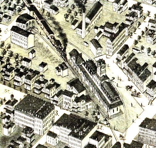
|

|

|
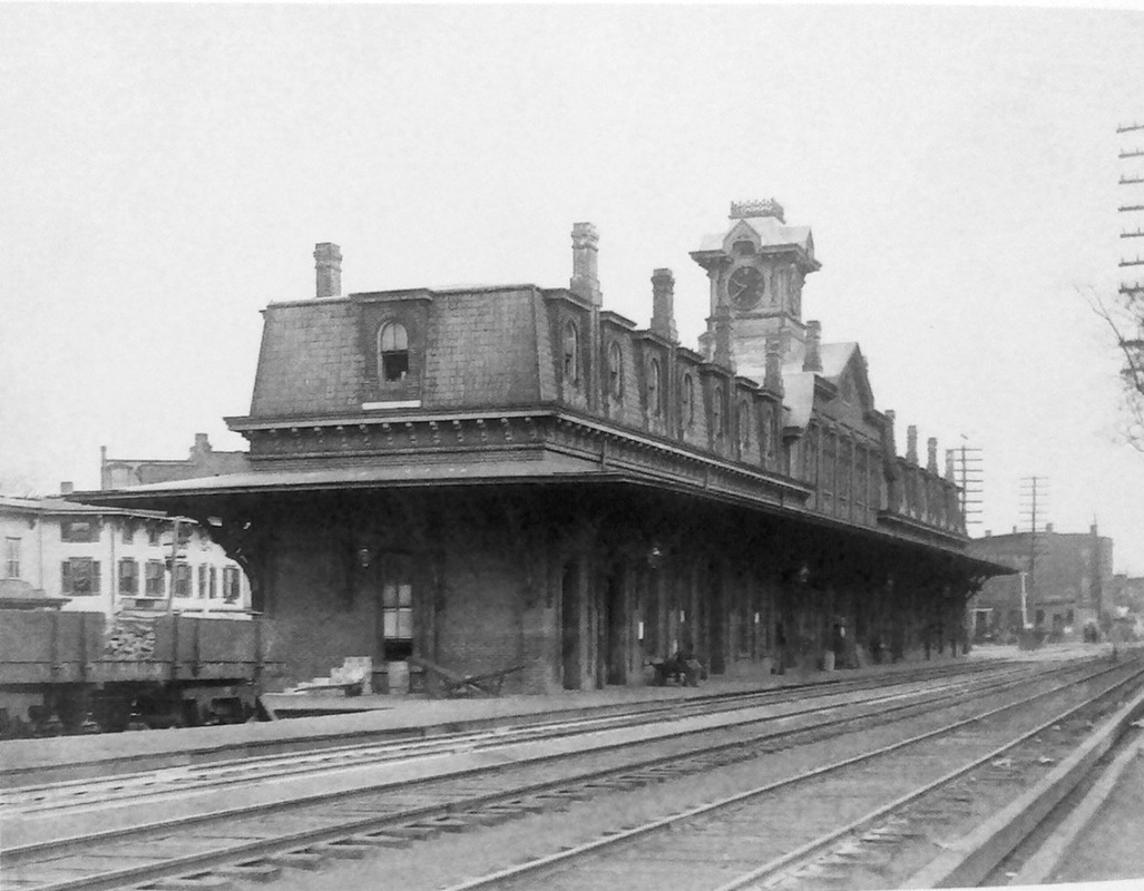
NORWALK/N2 [NY&NH, 1867]
A 5/16/1867 article says the "commodious and beautiful new depot erected at South Norwalk by the New York and New Haven Railroad Company, is completed, and will be occupied to-day. It is one of the finest structures of the kind in the State, and reflects much credit on the Company." Very similar to STAMFORD2, which debuted earlier in 1867, this one also had the mansard roof, central clock tower and multiple chimneys. In the 1875 map snippet at [1], the new station is seen adjacent to NORWALK1. That cross-gabled structure was now "being appropriated for freight use," according to the NY&NH annual report cited in the newspaper. Also seen is the three-stall engine house and turntable mentioned as having been built at this time. There are two switchman's shanties on the east end of the station that would be replaced in 1888 by the wooden block tower visible in the photo at [3]. Like its predecessor, this station was shared by the D&N and later its lessee, the HRR, whose passenger yard was on the north side of the station. The four-tracking of the line to New York, here as in Stamford and elsewhere, required the demolition of old stations to accommodate the elevated and realigned tracks. NORWALK/N2 was abandoned on 7/7/1895 and torn down shortly thereafter when NORWALK/N3 and NORWALK/N4 were built. [REFS: CRC14.1867.13; CH/05/16/1867/02; NA/12/25/1867/04; R91][rev112916]
A 5/16/1867 article says the "commodious and beautiful new depot erected at South Norwalk by the New York and New Haven Railroad Company, is completed, and will be occupied to-day. It is one of the finest structures of the kind in the State, and reflects much credit on the Company." Very similar to STAMFORD2, which debuted earlier in 1867, this one also had the mansard roof, central clock tower and multiple chimneys. In the 1875 map snippet at [1], the new station is seen adjacent to NORWALK1. That cross-gabled structure was now "being appropriated for freight use," according to the NY&NH annual report cited in the newspaper. Also seen is the three-stall engine house and turntable mentioned as having been built at this time. There are two switchman's shanties on the east end of the station that would be replaced in 1888 by the wooden block tower visible in the photo at [3]. Like its predecessor, this station was shared by the D&N and later its lessee, the HRR, whose passenger yard was on the north side of the station. The four-tracking of the line to New York, here as in Stamford and elsewhere, required the demolition of old stations to accommodate the elevated and realigned tracks. NORWALK/N2 was abandoned on 7/7/1895 and torn down shortly thereafter when NORWALK/N3 and NORWALK/N4 were built. [REFS: CRC14.1867.13; CH/05/16/1867/02; NA/12/25/1867/04; R91][rev112916]

|
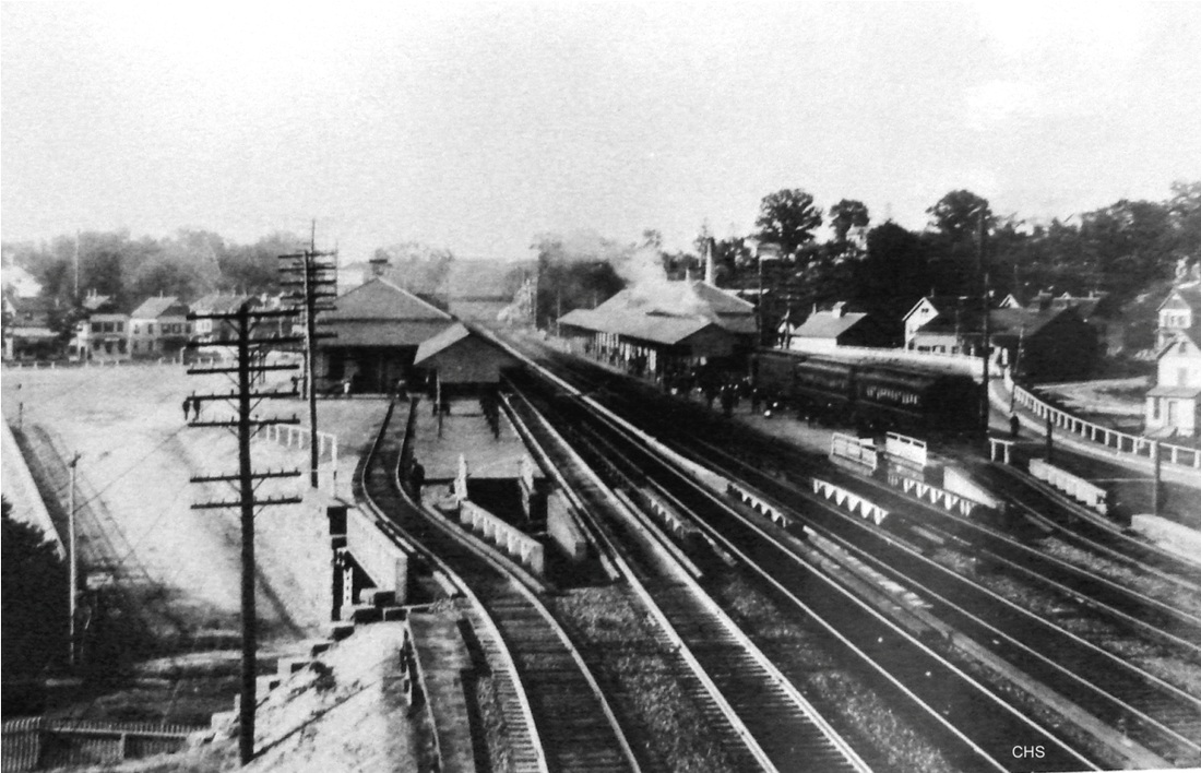
|
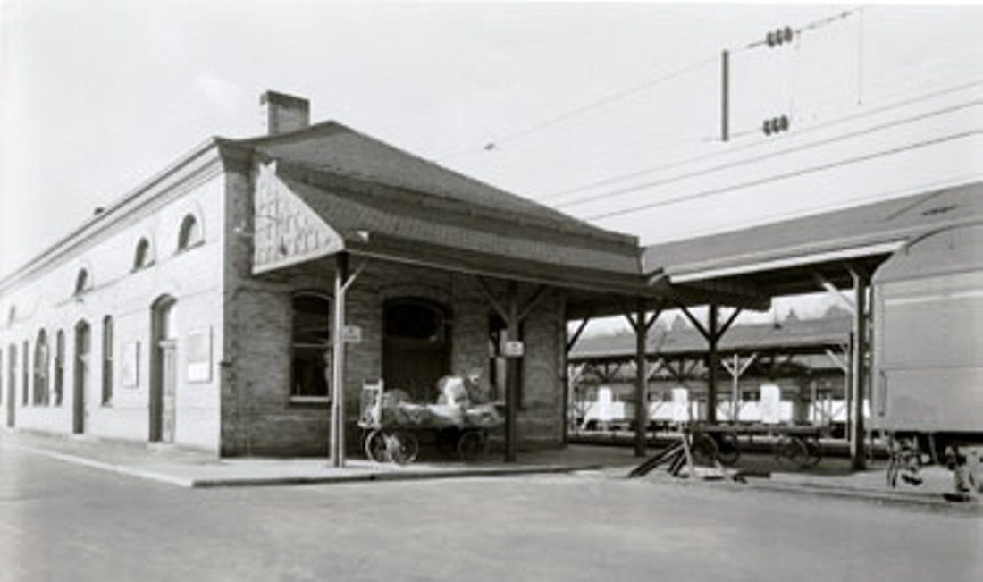
|
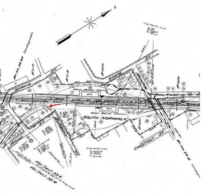
NORWALK/N3 [NYNH&H, 1895, WB]
This was the new westbound station, necessitated by the four-tracking of the New York Division. The Landis and Hughes 1899 map at [1] shows the 1895 twin railroad stations, as does the shot at [2]. New viaducts over Burbank and Monroe Sts. are evidence of the elevation of the line to eliminate grade crossings. The railroad commissioners said that two new stations were now in use south of the site of the old one. The photo at [3] looks to the west, with the stub-end tracks for the Danbury line at the east end of both stations. NORWALK/N4 is on the right. The photo at right shows the west end of this station. The 1915 val map at [4] has the Wilson Point branch marked with the red arrow. [REFS: CRC43.1895.12; NHER/09/27/1895/01][rev112916]
This was the new westbound station, necessitated by the four-tracking of the New York Division. The Landis and Hughes 1899 map at [1] shows the 1895 twin railroad stations, as does the shot at [2]. New viaducts over Burbank and Monroe Sts. are evidence of the elevation of the line to eliminate grade crossings. The railroad commissioners said that two new stations were now in use south of the site of the old one. The photo at [3] looks to the west, with the stub-end tracks for the Danbury line at the east end of both stations. NORWALK/N4 is on the right. The photo at right shows the west end of this station. The 1915 val map at [4] has the Wilson Point branch marked with the red arrow. [REFS: CRC43.1895.12; NHER/09/27/1895/01][rev112916]
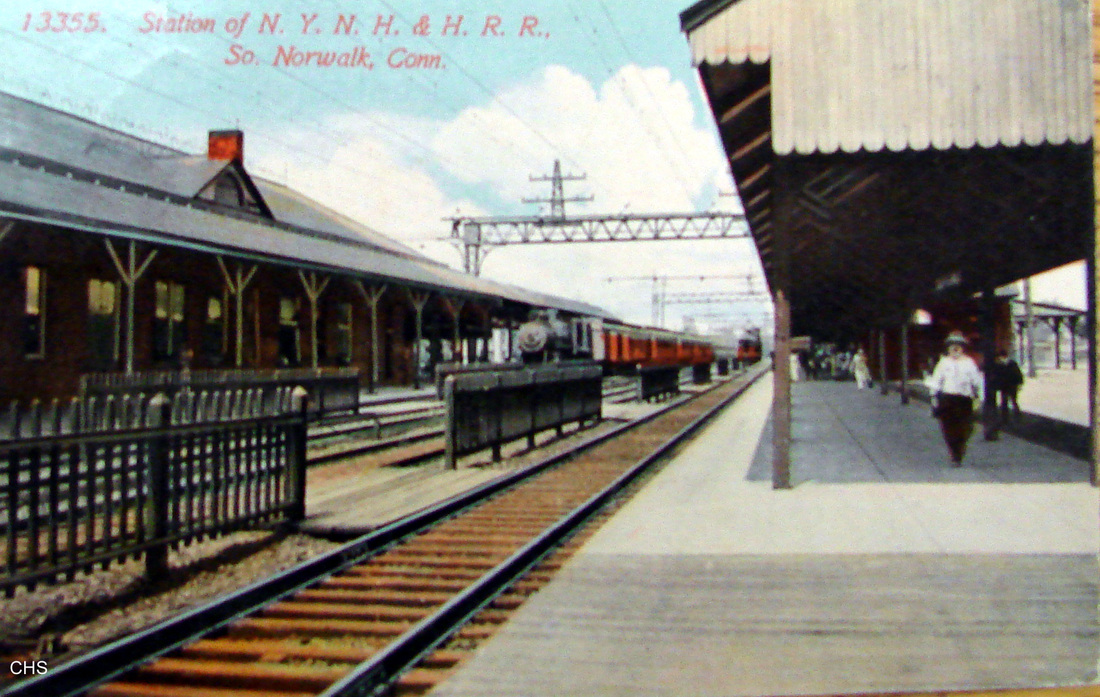
|
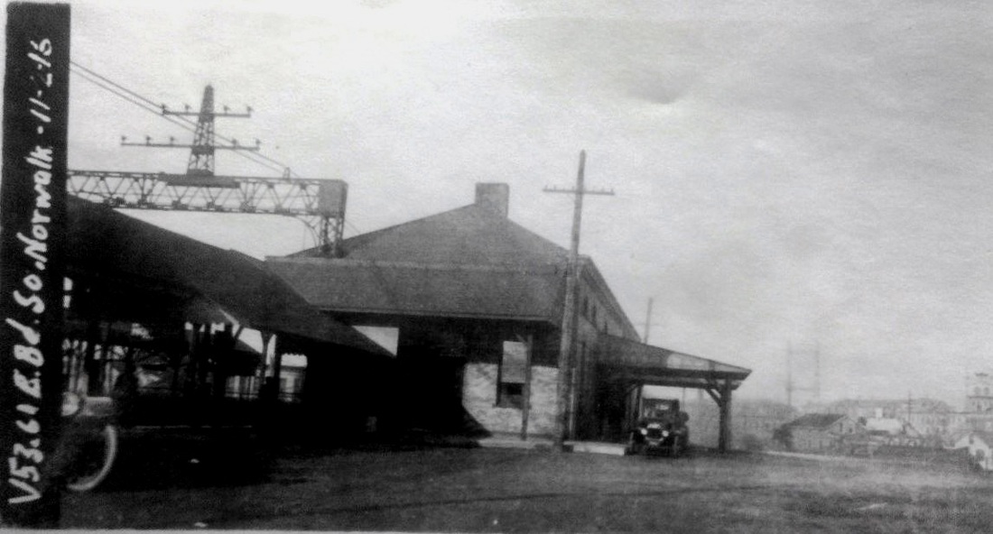
|
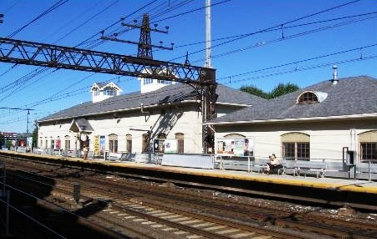
|
NORWALK/N4 [NYNH&H, 1895, EB]
This is the station on the eastbound side of the track, the far side in the postcard view at [1], and is also seen in the 1916 val photo at [2]. It is on the far end in the eastward view at [3] sometime after its 1994 renovation. [REFS: R91]
This is the station on the eastbound side of the track, the far side in the postcard view at [1], and is also seen in the 1916 val photo at [2]. It is on the far end in the eastward view at [3] sometime after its 1994 renovation. [REFS: R91]
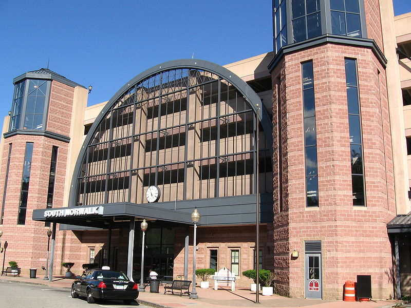
NORWALK/N5 [MN, 1996, WB]
This mammoth concrete and steel structure replaced NORWALK/N3 on westbound side of the tracks in 1996. [REFS: R91]
This mammoth concrete and steel structure replaced NORWALK/N3 on westbound side of the tracks in 1996. [REFS: R91]
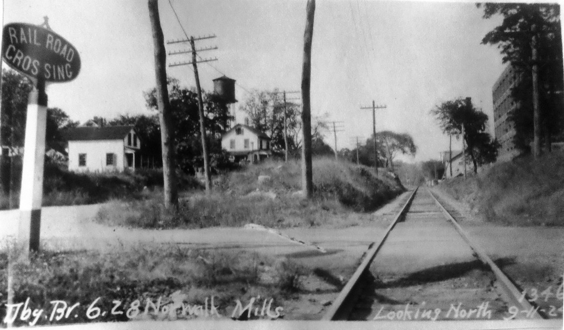
|
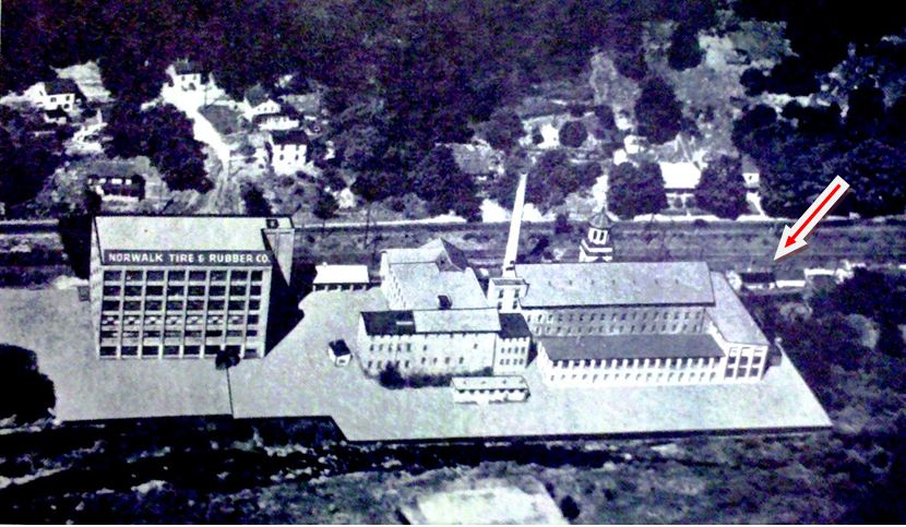
|
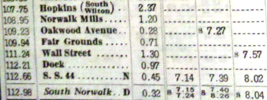
|

|
|
NORWALK MILLS [NYNH&H, c1945]
This stop in the northern part of town, which Cornwall says was created during WWII, seems to have been the successor to OAKLAND AVENUE where ETTs 153-158 [lower left] show one daily train each way stopping from 1943-1945. Our 9/30/1945 PTT shows trains serving NORWALK MILLS, .28 miles north, instead, in spite of a February, 1949 Times article saying that the railroad wanted to eliminate stops here, at Wall St., and at other points on the Danbury branch. NORWALK MILLS appears to have been the sole casualty some time between our 6/13/1954rev and 10/28/1956 PTTs. The 1905 map at lower middle shows the location of the original mill complex, in business since at least the Civil War. The PUC photo at upper left looks north from the crossing below the mill, today's Glover Ave., where the OAKLAND AVENUE station would stand. The newer building in the foreground, east of the track, is Norwalk Tire and Rubber, which took over the property in 1914 and the original mill is seen behind it in the distance. Our GE map at lower right shows the location of the two older stops, as well as the newer MERRITT 7 station that opened on 7/29/1985 and is in use today. The image at upper right shows the entire complex, perhaps in the 1940s, with the red arrow indicating approximately where riders would have boarded trains at NORWALK MILLS. Could the structure at the red arrow have been used as a station? [REFS: SL17.4.24; NYT/02/05/1949/07][rev032913]
This stop in the northern part of town, which Cornwall says was created during WWII, seems to have been the successor to OAKLAND AVENUE where ETTs 153-158 [lower left] show one daily train each way stopping from 1943-1945. Our 9/30/1945 PTT shows trains serving NORWALK MILLS, .28 miles north, instead, in spite of a February, 1949 Times article saying that the railroad wanted to eliminate stops here, at Wall St., and at other points on the Danbury branch. NORWALK MILLS appears to have been the sole casualty some time between our 6/13/1954rev and 10/28/1956 PTTs. The 1905 map at lower middle shows the location of the original mill complex, in business since at least the Civil War. The PUC photo at upper left looks north from the crossing below the mill, today's Glover Ave., where the OAKLAND AVENUE station would stand. The newer building in the foreground, east of the track, is Norwalk Tire and Rubber, which took over the property in 1914 and the original mill is seen behind it in the distance. Our GE map at lower right shows the location of the two older stops, as well as the newer MERRITT 7 station that opened on 7/29/1985 and is in use today. The image at upper right shows the entire complex, perhaps in the 1940s, with the red arrow indicating approximately where riders would have boarded trains at NORWALK MILLS. Could the structure at the red arrow have been used as a station? [REFS: SL17.4.24; NYT/02/05/1949/07][rev032913]

|

|
|
NORWICH/N1 [N&W, 1840]
Referred to as the Upper Depot, the Ferry St. station seen at [1] was likely completed for the 3/9/1840 opening of the N&W. It served as the first terminus of the road, of which the Boston Traveler said "until completion of the track to steamboat wharf, passengers will be taken from the present depot to the steamboats, free of charge." The red arrow to the right shows its location on the 1854NL at [2]. This depot was used until 1892 when the union station with the CVT, NORWICH/W3, was built, but was reopened in 1893 for boat train patrons. It resumed its old importance as the stop for this city in 1899 when the Groton Extension was opened and N&W trains could reach New London without using trackage rights on the NLN/CVT as they had since 1855. The 1876 map at [3] shows the station at our red arrow and Mr. Bailey once again captured the details precisely in the triple-arched portico on each end. Coincidentally, the only other station we have ever noticed this feature on in the state is TOLLAND AND WILLINGTON1. [REFS: BT/03/10/1840/03; Q21,52e][rev020717]
Referred to as the Upper Depot, the Ferry St. station seen at [1] was likely completed for the 3/9/1840 opening of the N&W. It served as the first terminus of the road, of which the Boston Traveler said "until completion of the track to steamboat wharf, passengers will be taken from the present depot to the steamboats, free of charge." The red arrow to the right shows its location on the 1854NL at [2]. This depot was used until 1892 when the union station with the CVT, NORWICH/W3, was built, but was reopened in 1893 for boat train patrons. It resumed its old importance as the stop for this city in 1899 when the Groton Extension was opened and N&W trains could reach New London without using trackage rights on the NLN/CVT as they had since 1855. The 1876 map at [3] shows the station at our red arrow and Mr. Bailey once again captured the details precisely in the triple-arched portico on each end. Coincidentally, the only other station we have ever noticed this feature on in the state is TOLLAND AND WILLINGTON1. [REFS: BT/03/10/1840/03; Q21,52e][rev020717]
|
|

|
NORWICH/N2 [N&W, 1840]
This depot came shortly after NORWICH1. The New World reported in September that "an extensive and handsome depot is now erecting at the landing place in Norwich..." It was called the Lower Depot for its geographic location and was usually labeled as a freight facility, as seen at the left arrow on the 1854NL map at [1]. It did, however, also serve steamboat passengers even after N&W trains started running to Allyns Point in 1843 and to Groton in 1899. The first structure burned on 7/14/1860 and was rebuilt. The view at [2] shows the depot in the center of the shot with a steamboat at dock. The val photo at [3] seems to be dated 5/2/1916. This freight structure collapsed from the force of the water during the hurricane of 1938 and we think it was eliminated at that time. [REFS: NW/09/26/1840/269; NYHT/07/16/1860/05; CR/07/21/1860/02; NLDC/12/11/1860/03; R79][rev020717]
This depot came shortly after NORWICH1. The New World reported in September that "an extensive and handsome depot is now erecting at the landing place in Norwich..." It was called the Lower Depot for its geographic location and was usually labeled as a freight facility, as seen at the left arrow on the 1854NL map at [1]. It did, however, also serve steamboat passengers even after N&W trains started running to Allyns Point in 1843 and to Groton in 1899. The first structure burned on 7/14/1860 and was rebuilt. The view at [2] shows the depot in the center of the shot with a steamboat at dock. The val photo at [3] seems to be dated 5/2/1916. This freight structure collapsed from the force of the water during the hurricane of 1938 and we think it was eliminated at that time. [REFS: NW/09/26/1840/269; NYHT/07/16/1860/05; CR/07/21/1860/02; NLDC/12/11/1860/03; R79][rev020717]

|

|

Tom Hassenmayer Collection
|
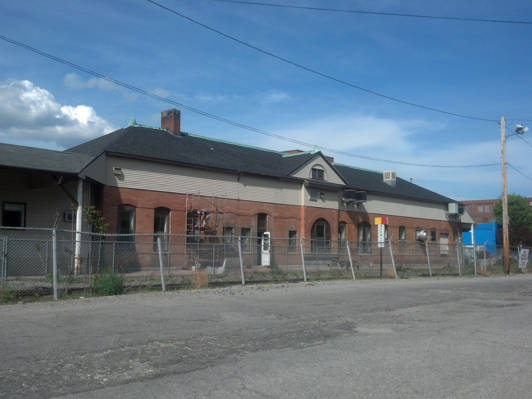
|
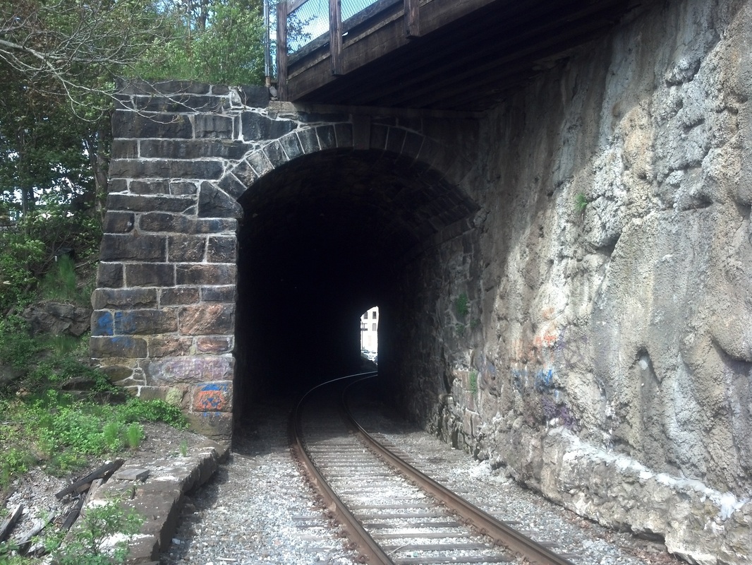
|
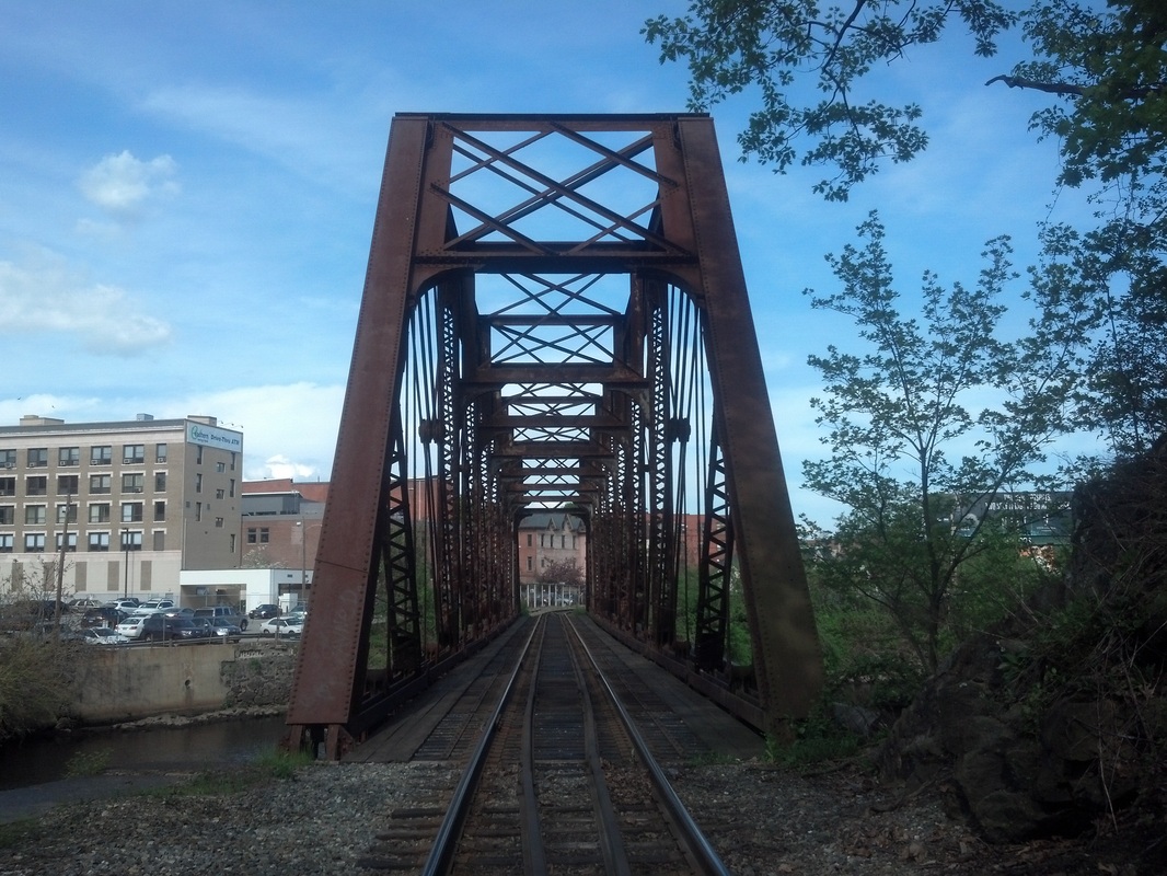
|
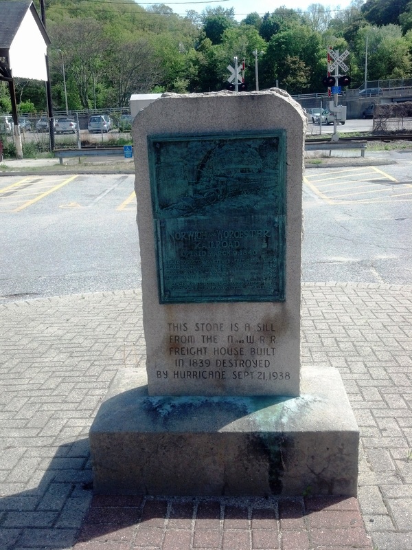
NORWICH/N3 [NYNH&H, 1900]
This station opened for business and public inspection on the evening of 1/27/1900, a Saturday. While speech-making was to be omitted, the Register said that music would be provided on this occasion of "general jubilation" for the city and the surrounding towns in the building that was "to be lighted with electricity furnished by the local company." Come spring, the paper went on, flower beds would be planted outside in keeping with "the highest standard of condition and appearance" that the Consolidated was known for. The early-1900s postcard at [1] shows a trackside view of the structure. The shot at [2] shows the street-side entrance canopies, which were a regular feature of this style station. The rare view at [3] looks northeast at the station and shows the 1876 Shetucket River bridge to ALLYNS POINT and, as of 6/2/1899, to NEW LONDON with the opening of the Groton Extension. Thereafter, the trains of the NY&NE/N&W, absorbed by the NYNH&H as the New England RR in 1898, used this bridge to go down the east side of the Thames River to get to Groton and the Whaling City. The tracks in the left foreground go to the steamboat dock and further on cross the Yantic River to reach the NLN which the N&W had used since 1854 to get to New London. Passenger service ended here on 4/31/1971 when Amtrak declined to include the N&W line in its system. Images [4], [5], [6] were taken on 5/10/2013 and show the station, the 1875 Laurel Hill tunnel, and the 1900 bridge that replaced the earlier one. The tablet pictured at [7] was erected for the N&W Centennial in 1940; it is made of granite from the sill of the 1840 freight house destroyed in the 1938 hurricane. According to Farnham, the locomotive portrayed is the Boston, the ninth N&W engine and one that for a time pulled the Boat Train to meet the steamships to New York. NORWICH/N3 is one of only two extant examples of this hipped-roof, ca. 1900 NYNH&H station style, the other being NORWALK/N4. BERLIN5 was gutted by fire on 12/21/2017 and razed thereafter. [REFS: NHER/07/01/1899/03; CRC47.1899.5,31; NHER/01/26/1900/05; NB/01/29/1900/05; R79; Q148ff [rev020717, 071919]
This station opened for business and public inspection on the evening of 1/27/1900, a Saturday. While speech-making was to be omitted, the Register said that music would be provided on this occasion of "general jubilation" for the city and the surrounding towns in the building that was "to be lighted with electricity furnished by the local company." Come spring, the paper went on, flower beds would be planted outside in keeping with "the highest standard of condition and appearance" that the Consolidated was known for. The early-1900s postcard at [1] shows a trackside view of the structure. The shot at [2] shows the street-side entrance canopies, which were a regular feature of this style station. The rare view at [3] looks northeast at the station and shows the 1876 Shetucket River bridge to ALLYNS POINT and, as of 6/2/1899, to NEW LONDON with the opening of the Groton Extension. Thereafter, the trains of the NY&NE/N&W, absorbed by the NYNH&H as the New England RR in 1898, used this bridge to go down the east side of the Thames River to get to Groton and the Whaling City. The tracks in the left foreground go to the steamboat dock and further on cross the Yantic River to reach the NLN which the N&W had used since 1854 to get to New London. Passenger service ended here on 4/31/1971 when Amtrak declined to include the N&W line in its system. Images [4], [5], [6] were taken on 5/10/2013 and show the station, the 1875 Laurel Hill tunnel, and the 1900 bridge that replaced the earlier one. The tablet pictured at [7] was erected for the N&W Centennial in 1940; it is made of granite from the sill of the 1840 freight house destroyed in the 1938 hurricane. According to Farnham, the locomotive portrayed is the Boston, the ninth N&W engine and one that for a time pulled the Boat Train to meet the steamships to New York. NORWICH/N3 is one of only two extant examples of this hipped-roof, ca. 1900 NYNH&H station style, the other being NORWALK/N4. BERLIN5 was gutted by fire on 12/21/2017 and razed thereafter. [REFS: NHER/07/01/1899/03; CRC47.1899.5,31; NHER/01/26/1900/05; NB/01/29/1900/05; R79; Q148ff [rev020717, 071919]

Connecticut Historical Society
|

|
NORWICH/W1 [NLW&P, 1849]
The NLW&P opened through Norwich on the west side of the Yantic River in 1849. The image at [1] shows its first station on North Thames St., the small building to the right, said to be adequate only for a dozen passengers. The Board of Railroad Commissioners, newly constituted in 1853, seems to echo this, saying in their first annual report that the "buildings used for the accommodation of passengers and freight at the station at Norwich Landing, are inconvenient and do not reasonably accommodate the public." While they acknowledge the confined space the NLW&P had to work with here, they conclude that "plans, however, are devised, and efforts making, to bring about at an early day a result so desirable" for creating suitable facilities for the public. The captioning on one copy of this photo says that the structure on the left is the water tank and that the freight depot was "located in the rear." The image at [2] is from the 1854NL map and shows the new connector that opened for service in February, 1854 to link the N&W with the NLW&P, allowing trains of the former road to get to New London via trackage rights. The station photo shows the curve of the connector in the foreground and therefore dates the shot to between 1854 and 1856 when the next station was built on the other side of the track. Later maps show the trestle in the distance is a railroad spur dead-ending at the NLW&P track. It probably opened in 1854 with the connector as a freight spur with direct access to the N&W's lower depot and without having to go down the NLW&P main line. [REFS: NC/02/22/1854/02; HDC/08/18/1853/02; CRC1.1854.8; HDC/07/26/1881/04; Q85,91; R79][rev020717]
The NLW&P opened through Norwich on the west side of the Yantic River in 1849. The image at [1] shows its first station on North Thames St., the small building to the right, said to be adequate only for a dozen passengers. The Board of Railroad Commissioners, newly constituted in 1853, seems to echo this, saying in their first annual report that the "buildings used for the accommodation of passengers and freight at the station at Norwich Landing, are inconvenient and do not reasonably accommodate the public." While they acknowledge the confined space the NLW&P had to work with here, they conclude that "plans, however, are devised, and efforts making, to bring about at an early day a result so desirable" for creating suitable facilities for the public. The captioning on one copy of this photo says that the structure on the left is the water tank and that the freight depot was "located in the rear." The image at [2] is from the 1854NL map and shows the new connector that opened for service in February, 1854 to link the N&W with the NLW&P, allowing trains of the former road to get to New London via trackage rights. The station photo shows the curve of the connector in the foreground and therefore dates the shot to between 1854 and 1856 when the next station was built on the other side of the track. Later maps show the trestle in the distance is a railroad spur dead-ending at the NLW&P track. It probably opened in 1854 with the connector as a freight spur with direct access to the N&W's lower depot and without having to go down the NLW&P main line. [REFS: NC/02/22/1854/02; HDC/08/18/1853/02; CRC1.1854.8; HDC/07/26/1881/04; Q85,91; R79][rev020717]

|
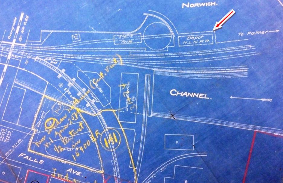
|
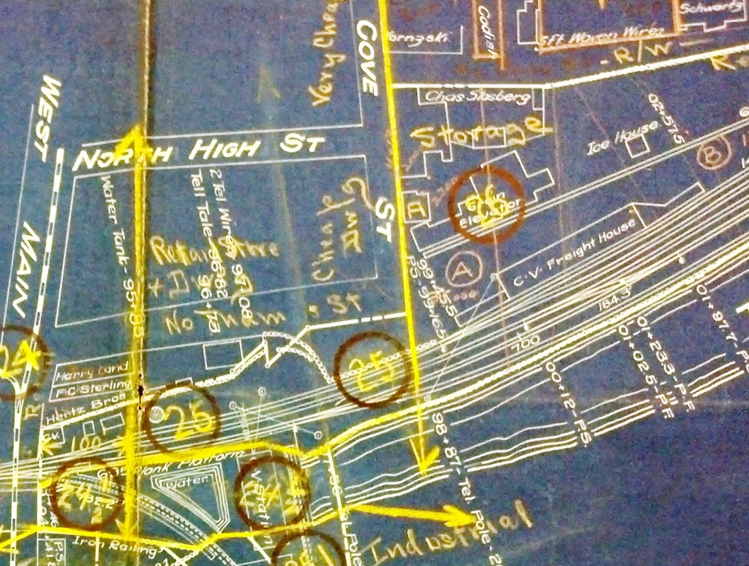
|
NORWICH/W2 [NLN, 1855]
The 1876 Bailey bird's-eye map at [1] shows this depot, the NLN's replacement for NORWICH/W1. Farnham says, without citation, that this station was built in 1863 but we can find no evidence for that. We do find the railroad commissioners saying in their 1855 annual report that "a new station house has been commenced" above the wharf bridge, and stating in 1856 that "since our last report, the Company have erected a commodious depot at Norwich..." The bridge reference goes back to section 19 in the charter requiring the NLW&P to establish a station between the wharf bridge, today's West Main St., and Waterman's Point to the south. With the relocation of the station above the bridge, this interesting charter stipulation was repealed. Farnham also maintains that this depot would be torn down in 1893 after its successor was built, but it is still standing on the 1917 val map at [2] and it is seen as well as on the 1912 Bailey aero map at [2] in the next entry. The map at [3] dates prior to 1939 and shows this structure enlarged. Its ultimate fate is unknown. [REFS: CRC2.1855.17; CRC3.1856.31; NHER/02/05/1891/01; Q92; R79][rev020717]
The 1876 Bailey bird's-eye map at [1] shows this depot, the NLN's replacement for NORWICH/W1. Farnham says, without citation, that this station was built in 1863 but we can find no evidence for that. We do find the railroad commissioners saying in their 1855 annual report that "a new station house has been commenced" above the wharf bridge, and stating in 1856 that "since our last report, the Company have erected a commodious depot at Norwich..." The bridge reference goes back to section 19 in the charter requiring the NLW&P to establish a station between the wharf bridge, today's West Main St., and Waterman's Point to the south. With the relocation of the station above the bridge, this interesting charter stipulation was repealed. Farnham also maintains that this depot would be torn down in 1893 after its successor was built, but it is still standing on the 1917 val map at [2] and it is seen as well as on the 1912 Bailey aero map at [2] in the next entry. The map at [3] dates prior to 1939 and shows this structure enlarged. Its ultimate fate is unknown. [REFS: CRC2.1855.17; CRC3.1856.31; NHER/02/05/1891/01; Q92; R79][rev020717]
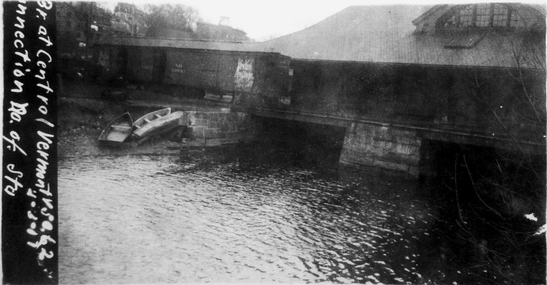
Dave Peters Collection
|

|

|

|
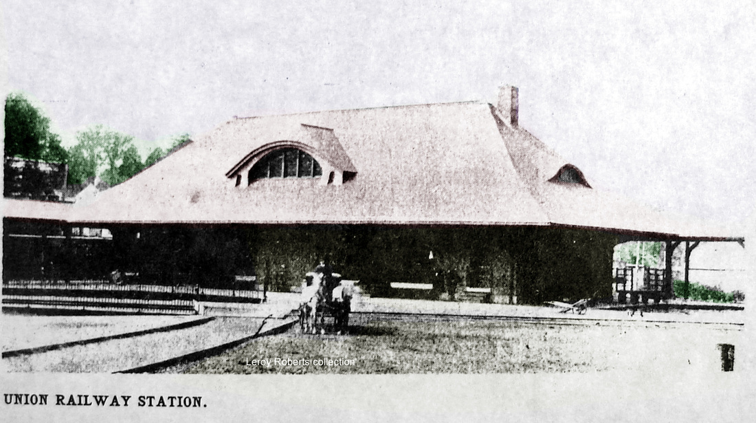
|
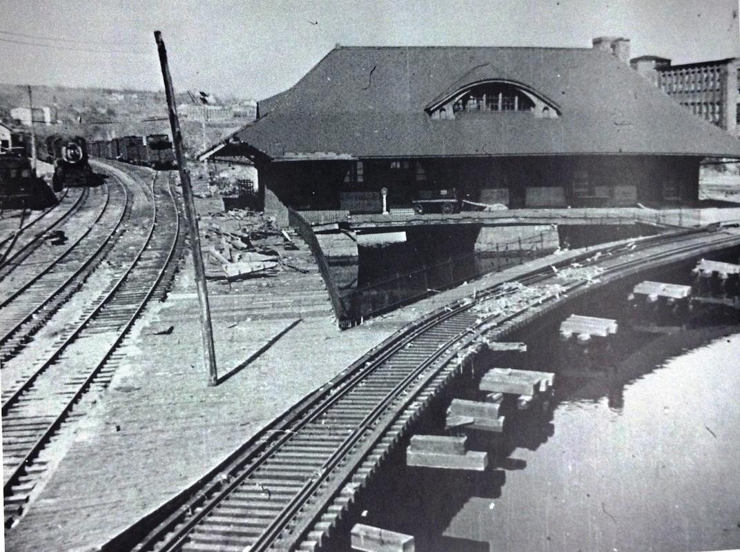
|
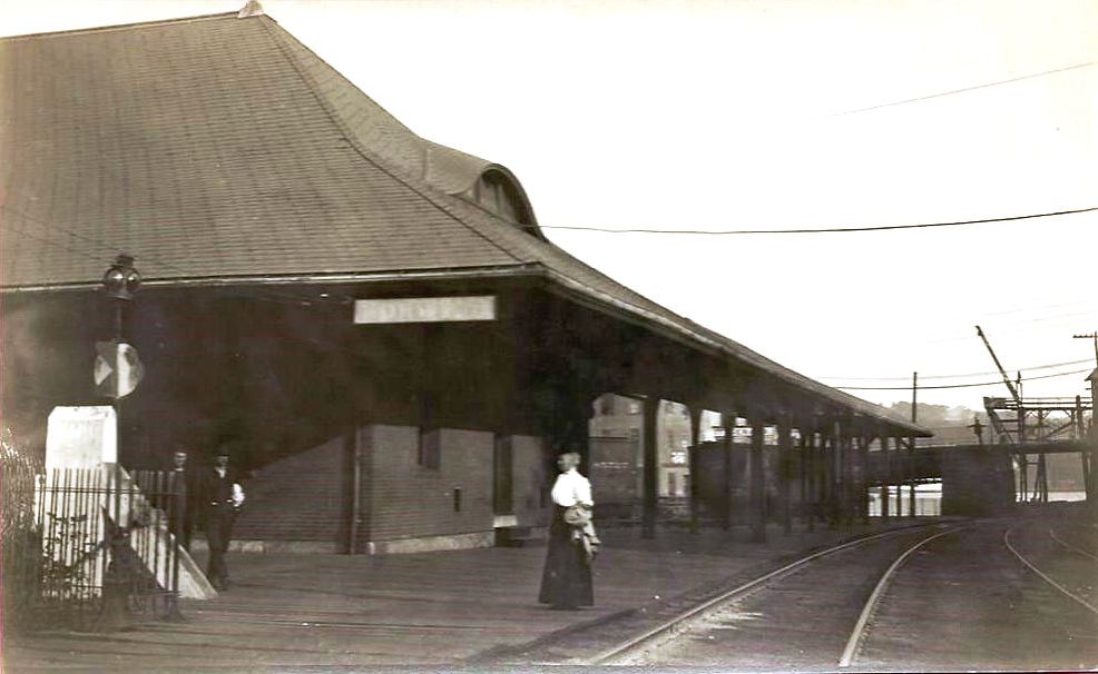
NORWICH/W3 [NY&NE/CVT, 1892]
This was one of the several union stations, others being NEW BRITAIN2 and WILLIMANTIC2, that were ordered by legislative act because of the failure of the railroads to cooperate with each other. The railroad commissioners held three hearings on where this one was to be built. The Central Wharf location that was ultimately chosen was preferred by the city but not by the railroads who said that the preliminary expenses alone would cost over $100,000, presumably in large part for the "great amount of piling" that would have to be done for the portion that was to stand over the river. Work was reportedly to begin "within the next few days" on 4/18/1891 and Farnham tells us (without citation) that all trains on 10/3/1892 and thereafter were to "depart from and arrive at Union Station, Norwich." John Roy informs us that the prestigious Shepley, Rutan and Coolidge, successor firm to H.H. Richardson, was hired to design the spacious Romanesque-style station and, in fact, some of the plans are found at Harvard. While granite and brownstone were the originally planned materials, the ICC field notes say the exterior construction was of "common brick." Of impressive appearance and dimension nevertheless, the two-story, 37x105-ft building that cost $75,000 was a victim of unfortunate timing. Prior to its debut, when N&W trains were using the NLN line on the west side of the Thames River to get to New London, a union depot here made sense. Within six years, however, the NYNH&H would get control of the N&W and would complete its connection to Groton in 1899 on the east side of the river. With NYNH&H trains using the new route, this station was ultimately left to the CVT, which was then operating the NLN. The 1917 val photo at [1] shows NORWICH/W3 straddling the west channel of the Yantic River with NYNH&H box cars parked on the spur behind the depot. The map at [2] is a 1912 Bailey aero view and shows the station at the locator number 11 that we have circled in red. The 1915 val map at [3] shows the station as part of NYNH&H assets, though it was jointly owned with the CVT. The shot at [4] is Lewis H. Benton #2395 taken in 1929 that shows the N&W connector as well as the CVT running on the west shore. The view at [5] shows the Richardsonian eyebrow window on the east, as well as the south, side. This station would serve until after the hurricane of 1938. The photo at [6] shows it still standing after the storm, appearing to have fared pretty well, though one report we read said a railroad station in town, possibly this one, was almost completed submerged in the high waters of the storm. While damage to the piers may indeed have been a factor, no doubt the CVT took this opportunity to unload what must have become a white elephant for them. The company was also abandoning stations and cutting back passenger service at other, albeit smaller, stations all along its line by the late 1930s. The rubble-cleared area over the water apparently was deemed safe enough for small freight interchange yard as seen in subsequent photographs. The photo at [7] looks south toward the Main St. overpass. The 1946 topographic map does not show the connector, although Karr says it was not abandoned until 1966 and Farnham says it was out of service but still in place when he was writing in 1973. [REFS: NYT/01/23/1889/02; NYT/05/13/1889/05; HC/04/11/1890/06; HC/04/29/1890/06; HC/07/30/1890/06; HC/04/18/1891/06; CRC39.1891.16: foundation; HDC/09/23/1892/02; NHER/09/23/1892/04; CRC40.1892.17; Q91+,148a,180g; K106; R79][rev020717, 052919]
This was one of the several union stations, others being NEW BRITAIN2 and WILLIMANTIC2, that were ordered by legislative act because of the failure of the railroads to cooperate with each other. The railroad commissioners held three hearings on where this one was to be built. The Central Wharf location that was ultimately chosen was preferred by the city but not by the railroads who said that the preliminary expenses alone would cost over $100,000, presumably in large part for the "great amount of piling" that would have to be done for the portion that was to stand over the river. Work was reportedly to begin "within the next few days" on 4/18/1891 and Farnham tells us (without citation) that all trains on 10/3/1892 and thereafter were to "depart from and arrive at Union Station, Norwich." John Roy informs us that the prestigious Shepley, Rutan and Coolidge, successor firm to H.H. Richardson, was hired to design the spacious Romanesque-style station and, in fact, some of the plans are found at Harvard. While granite and brownstone were the originally planned materials, the ICC field notes say the exterior construction was of "common brick." Of impressive appearance and dimension nevertheless, the two-story, 37x105-ft building that cost $75,000 was a victim of unfortunate timing. Prior to its debut, when N&W trains were using the NLN line on the west side of the Thames River to get to New London, a union depot here made sense. Within six years, however, the NYNH&H would get control of the N&W and would complete its connection to Groton in 1899 on the east side of the river. With NYNH&H trains using the new route, this station was ultimately left to the CVT, which was then operating the NLN. The 1917 val photo at [1] shows NORWICH/W3 straddling the west channel of the Yantic River with NYNH&H box cars parked on the spur behind the depot. The map at [2] is a 1912 Bailey aero view and shows the station at the locator number 11 that we have circled in red. The 1915 val map at [3] shows the station as part of NYNH&H assets, though it was jointly owned with the CVT. The shot at [4] is Lewis H. Benton #2395 taken in 1929 that shows the N&W connector as well as the CVT running on the west shore. The view at [5] shows the Richardsonian eyebrow window on the east, as well as the south, side. This station would serve until after the hurricane of 1938. The photo at [6] shows it still standing after the storm, appearing to have fared pretty well, though one report we read said a railroad station in town, possibly this one, was almost completed submerged in the high waters of the storm. While damage to the piers may indeed have been a factor, no doubt the CVT took this opportunity to unload what must have become a white elephant for them. The company was also abandoning stations and cutting back passenger service at other, albeit smaller, stations all along its line by the late 1930s. The rubble-cleared area over the water apparently was deemed safe enough for small freight interchange yard as seen in subsequent photographs. The photo at [7] looks south toward the Main St. overpass. The 1946 topographic map does not show the connector, although Karr says it was not abandoned until 1966 and Farnham says it was out of service but still in place when he was writing in 1973. [REFS: NYT/01/23/1889/02; NYT/05/13/1889/05; HC/04/11/1890/06; HC/04/29/1890/06; HC/07/30/1890/06; HC/04/18/1891/06; CRC39.1891.16: foundation; HDC/09/23/1892/02; NHER/09/23/1892/04; CRC40.1892.17; Q91+,148a,180g; K106; R79][rev020717, 052919]
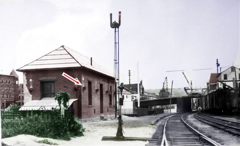
|
National Archives
|

Jack Delano
|
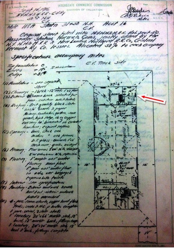
National Archives
NORWICH/W4 [CVT, 1939]
Richard Fleischer has offered the observation that this depot might not have been new in 1939, but rather a remnant of the preceding union station. He based this theory on the stone window sills and lintels, the protruding corbels and the unpainted areas above each of the latter. Though photos of the old union station don't easily reveal such details, the ICC field notes seem to supply the answer. The corbels, seen at our red arrow in the photo at [1] and in the ICC snippet at [2], supported the braces for the roof overhang. The photo must be just after the 'rump' depot was born. The November, 1940 shot at [3] seems to show it now freshly painted and sporting a signboard not seen in the first photo. It was taken by Jack Delano for the Farm Security Administration, a federal agency that documented life in Depression-era America. The field notes at [4] show the first-floor footprint and our red arrow points to the west wing that was left standing in 1939. The clincher in following up this unusual transformation came in a trip to the Otis Library [click here], which produced the the article cited in part here: "Cutting Down Size of Central Vermont Railway Station. Within a short time the old Central Vermont railway passenger station, off Falls avenue, will be only a fraction of its original size. Wrecking operations on this brick building are now going on which will eliminate the big waiting room section and leave only the westerly end of the building for railroad use. The rest of the building will be leveled to the ground. In the section that will be left, there will be a sizable waiting room, large enough to accommodate the present day passenger traffic, a telegraph room and ticket office, room for storage and records, and a toilet room. As this end of the building is shut off from the easterly end by a brick wall, it can be readily adapted to the plans. The roof will be lowered to fit in with the plans and the heating apparatus now in this part of the building will be retained. As there are only two passenger trains daily on the road now, one north in the morning and the other south at night, this diminished space will be ample for the present day traffic on the road… It was remarked Tuesday that the station was built at a cost of about $75,000 but the railroad had to give it away in order to get it torn down." The view in the photo at [1] looks south with the Main St. overpass in the distance. The 1940 shot at [3] looks east and, behind this downsized depot, freight cars can be seen taking up the space where the rest of the old union station once stood. CV passenger service was discontinued altogether in 1947 and this station reportedly came down between 1972 and 1976. The PUC had allowed the freight agency to close in May, 1972, in favor of the Serve-Centre computerized system. [REFS: NB/05/31/1939/10; HC/12/04/1966/15C3; HC/05/07/1972/15C3; K101,106; Q93][rev100318]
Richard Fleischer has offered the observation that this depot might not have been new in 1939, but rather a remnant of the preceding union station. He based this theory on the stone window sills and lintels, the protruding corbels and the unpainted areas above each of the latter. Though photos of the old union station don't easily reveal such details, the ICC field notes seem to supply the answer. The corbels, seen at our red arrow in the photo at [1] and in the ICC snippet at [2], supported the braces for the roof overhang. The photo must be just after the 'rump' depot was born. The November, 1940 shot at [3] seems to show it now freshly painted and sporting a signboard not seen in the first photo. It was taken by Jack Delano for the Farm Security Administration, a federal agency that documented life in Depression-era America. The field notes at [4] show the first-floor footprint and our red arrow points to the west wing that was left standing in 1939. The clincher in following up this unusual transformation came in a trip to the Otis Library [click here], which produced the the article cited in part here: "Cutting Down Size of Central Vermont Railway Station. Within a short time the old Central Vermont railway passenger station, off Falls avenue, will be only a fraction of its original size. Wrecking operations on this brick building are now going on which will eliminate the big waiting room section and leave only the westerly end of the building for railroad use. The rest of the building will be leveled to the ground. In the section that will be left, there will be a sizable waiting room, large enough to accommodate the present day passenger traffic, a telegraph room and ticket office, room for storage and records, and a toilet room. As this end of the building is shut off from the easterly end by a brick wall, it can be readily adapted to the plans. The roof will be lowered to fit in with the plans and the heating apparatus now in this part of the building will be retained. As there are only two passenger trains daily on the road now, one north in the morning and the other south at night, this diminished space will be ample for the present day traffic on the road… It was remarked Tuesday that the station was built at a cost of about $75,000 but the railroad had to give it away in order to get it torn down." The view in the photo at [1] looks south with the Main St. overpass in the distance. The 1940 shot at [3] looks east and, behind this downsized depot, freight cars can be seen taking up the space where the rest of the old union station once stood. CV passenger service was discontinued altogether in 1947 and this station reportedly came down between 1972 and 1976. The PUC had allowed the freight agency to close in May, 1972, in favor of the Serve-Centre computerized system. [REFS: NB/05/31/1939/10; HC/12/04/1966/15C3; HC/05/07/1972/15C3; K101,106; Q93][rev100318]

|
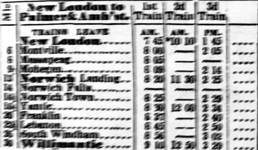
|
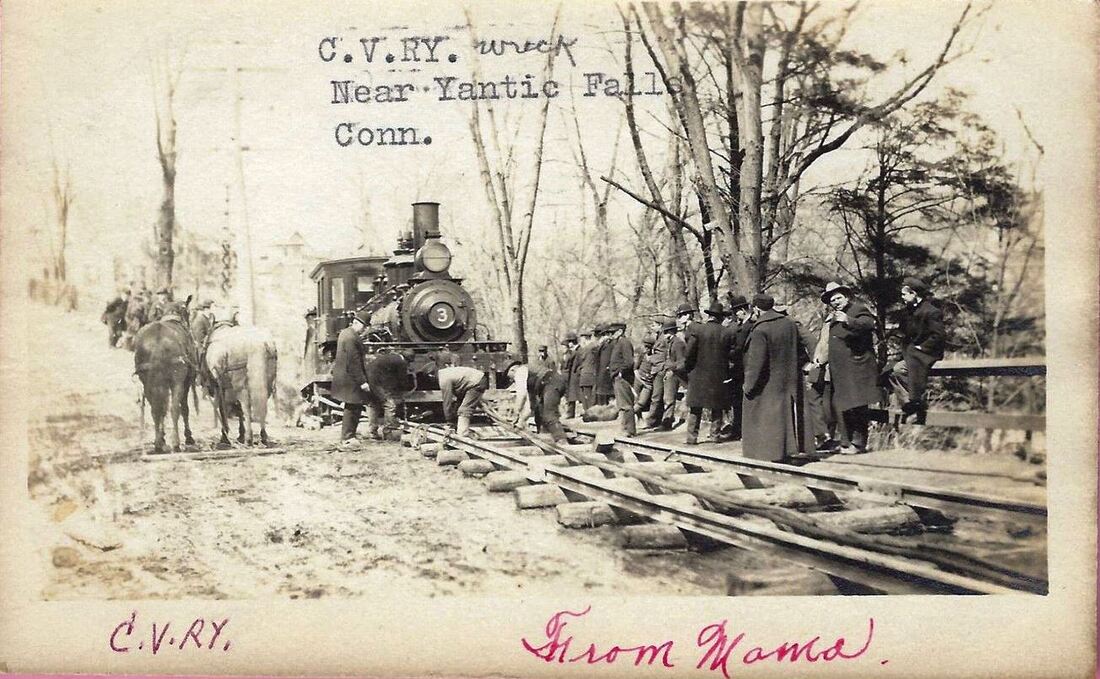
|
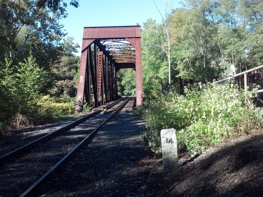
Al Weaver photo
|
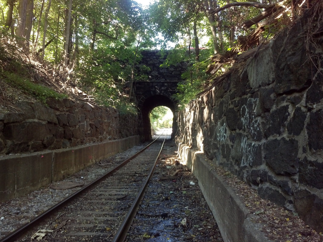
Al Weaver photo
|

Linda Grant photo
|
NORWICH FALLS [NLW&P, 1852]
This does not appear to have been an original stop in the town of Norwich on the NLW&P when it opened in 1849. Scant information exists about this stop but the O.H. Bailey bird's-eye map snippet at [1] shows us the area in 1876. The NLW&P, by then the NLN, crosses the Yantic River as it arrives at the village in a ravine. Our left arrow points to the only building at track level that might have been the depot here. Our right arrow points to the handsome stone arch portal for the short tunnel, still extant, under Sherman St. An 11/6/1852 notice in the Norwich Evening Courier says: "N.L.W and P. RAILROAD -- On and after Monday, 15th November, the trains will receive and land passengers at Norwich Falls; as a Flag Station. A.G. Darrow, Supt." The image at [2] is from an 1853 timtable and shows an asterisk for the 10 a.m. train from New London, which designates it as a freight with passenger car attached. These trains did not stop here or at MASSAPEAG, MOHEGAN, NORWICH TOWN, FRANKLIN or LEBANON to take on or let off passengers. We are not sure what that means about freight service per se but, like all communities with water power resources, there was industry here, beginning with the first paper mill in the state, founded by Christopher Leffingwell in 1766. The number 42 in the map key lists the building seen at [1] as Hopkins & Allen, a pistol manufacturing concern. The Falls Co. Cotton Mill was by far the largest employer in the vicinity and also took advantage of the water power of the Yantic River. An 1867 article reminds us that the Yantic River could also do damage, its flood waters taking the J.H. Smith & Co.'s bleachery which was " ... above the railroad depot at the Falls." The undated post card photo at [3] from 'Mama' shows CV No. 3 derailed near here. Al Weaver took his photos on 9/29/2013. The shot at [4] captures milepost 14 just south of the CV bridge crossing the river. Note this is the same mileage as on the timetable at [2], unchanged, not surprisingly, after 164 years. The view at [5] looks at the beautiful stonework of the undercrossing at Sherman St. Linda Grant's shot at [6] captures the impressive falls with pedestrian and railroad bridges above. How long rail service lasted at this stop and the ultimate fate of the depot building are not yet known. The distractedwandered.com website relates the fascinating Native American tale of Uncas' Leap at the Lower Falls and pictures the beauty of the narrow, rocky channel and rapids between here and the Upper Falls in all seasons. It looks be well worth a visit any time of the year! [REFS: NEC/11/06/1852/03; NLWC/12/02/1852/04; CCO/10/06/1860/03;; HC/04/09/1989/D1F][posted111722]
NORWICH LANDING [> THAMESVILLE]

NORWICHTOWN1 [NLW&P, 1849]
This depot was located as seen on the 1854NL map. A small station was authorized here on 9/3/1850 at a cost of $300. No photo yet. [REFS: W37][rev033013]
This depot was located as seen on the 1854NL map. A small station was authorized here on 9/3/1850 at a cost of $300. No photo yet. [REFS: W37][rev033013]
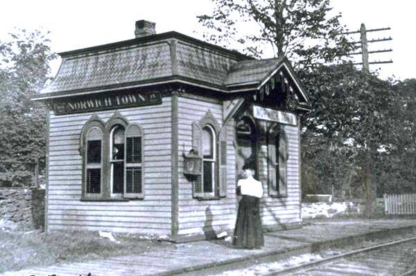
|

|
NORWICHTOWN2 [CVT, 1876]
The January, 1877 railroad commissioners' report names Norwich Town as one of the locations where "new and convenient passenger depots have been built." The Lewis H. Benton photo at right, his #2822, was taken in 1931. Fellow photographer Irving N. Drake and his automobile, which provided transportation for the duo, are seen at right in the photo. This station may have been closed by this time if the boarded-up windows are any indication. [REFS: CRC24.1877.18][rev 110621]
The January, 1877 railroad commissioners' report names Norwich Town as one of the locations where "new and convenient passenger depots have been built." The Lewis H. Benton photo at right, his #2822, was taken in 1931. Fellow photographer Irving N. Drake and his automobile, which provided transportation for the duo, are seen at right in the photo. This station may have been closed by this time if the boarded-up windows are any indication. [REFS: CRC24.1877.18][rev 110621]