Track 12: CT Passenger Stations, SO
See TCS Home Page links for notes, abbreviations, and sources.
Use Track 11 map link to locate stations, rail and trolley lines, and POIs.
Use Track 11 map link to locate stations, rail and trolley lines, and POIs.

Greenwich Historical Society
|

|

|
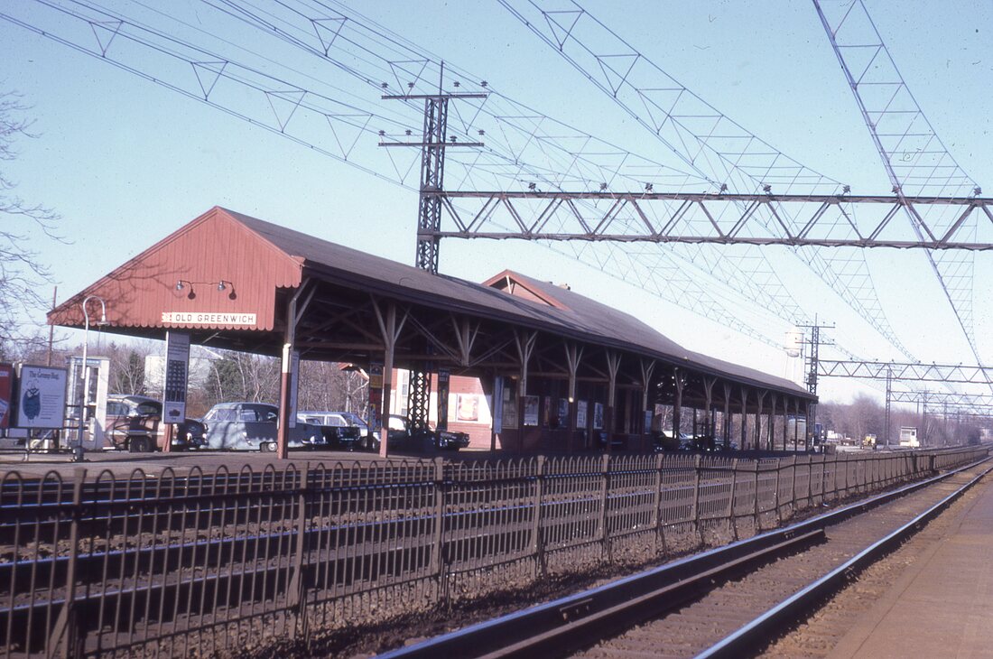
SOUND BEACH1 [NYNH&H, 1879, EB]
First efforts to add this stop in the town of Greenwich were reported in the Palladium in 1879 which said that "... The Consolidated road has decided to establish a station at Marshall's Corners, half-way between Riverside and Stamford. The property owners have agreed to subscribe about $1,000 for a new depot building and to take care of it for a given time, when it is to be maintained by the railroad company." By June it was open for business, with the Stamford Advocate saying that "... Provision having been made for the trains of the New Haven railroad to stop at suitable hours at the new station at Sound Beach..." The location was in the southeast corner of the Sound Beach Ave. grade crossing, based the Register report that on 1/26/1892 the depot "... caught fire and burned to the ground, causing all east bound trains to be delayed..." Another paper adds that the post office, established on 3/18/1880, was located in the building; the mail was saved but the baggage "... was consumed. The loss is about $2,500." The fire was thought to be caused by the usual culprit, a spark from a passing locomotive. The NRHP nomination form for SOUND BEACH2 [see next entry] says that the railroad "reluctantly allowed" this station to be built around 1875. We cannot comment on the reluctance, but our research gives a more specific date of 1879. It also says, this plausible, that the name of the stop was chosen because the NYNH&H did not like stations with similar names and GREENWICH, farther west, was already taken. The NRHP documentation does corroborate that the first station was "constructed, furnished and operated at the expense of the area's residents." IMAGES: [1] 1880s view of station; [2] 1867 map showing no station at rightmost arrow, none at RIVERSIDE yet, but one already at COS COB; [3] 1882 RAM map first show this stop. [REFS: 1851TT; 1879TT; NHDP/04/05/1879/04; SAD/06/20/1879/02; RRM1882; 1883TT; HC/07/30/1890/06; NHER/01/27/1892/03; WED/01/27/1892/05; Warmsley, p223: post office ][rev060222, 050323]
First efforts to add this stop in the town of Greenwich were reported in the Palladium in 1879 which said that "... The Consolidated road has decided to establish a station at Marshall's Corners, half-way between Riverside and Stamford. The property owners have agreed to subscribe about $1,000 for a new depot building and to take care of it for a given time, when it is to be maintained by the railroad company." By June it was open for business, with the Stamford Advocate saying that "... Provision having been made for the trains of the New Haven railroad to stop at suitable hours at the new station at Sound Beach..." The location was in the southeast corner of the Sound Beach Ave. grade crossing, based the Register report that on 1/26/1892 the depot "... caught fire and burned to the ground, causing all east bound trains to be delayed..." Another paper adds that the post office, established on 3/18/1880, was located in the building; the mail was saved but the baggage "... was consumed. The loss is about $2,500." The fire was thought to be caused by the usual culprit, a spark from a passing locomotive. The NRHP nomination form for SOUND BEACH2 [see next entry] says that the railroad "reluctantly allowed" this station to be built around 1875. We cannot comment on the reluctance, but our research gives a more specific date of 1879. It also says, this plausible, that the name of the stop was chosen because the NYNH&H did not like stations with similar names and GREENWICH, farther west, was already taken. The NRHP documentation does corroborate that the first station was "constructed, furnished and operated at the expense of the area's residents." IMAGES: [1] 1880s view of station; [2] 1867 map showing no station at rightmost arrow, none at RIVERSIDE yet, but one already at COS COB; [3] 1882 RAM map first show this stop. [REFS: 1851TT; 1879TT; NHDP/04/05/1879/04; SAD/06/20/1879/02; RRM1882; 1883TT; HC/07/30/1890/06; NHER/01/27/1892/03; WED/01/27/1892/05; Warmsley, p223: post office ][rev060222, 050323]
National Archives
|
|
|
|
Bob Gambling photo
|
|
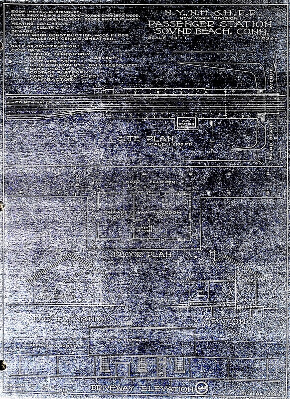
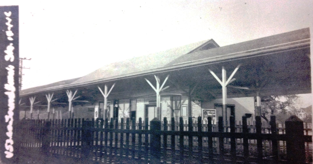
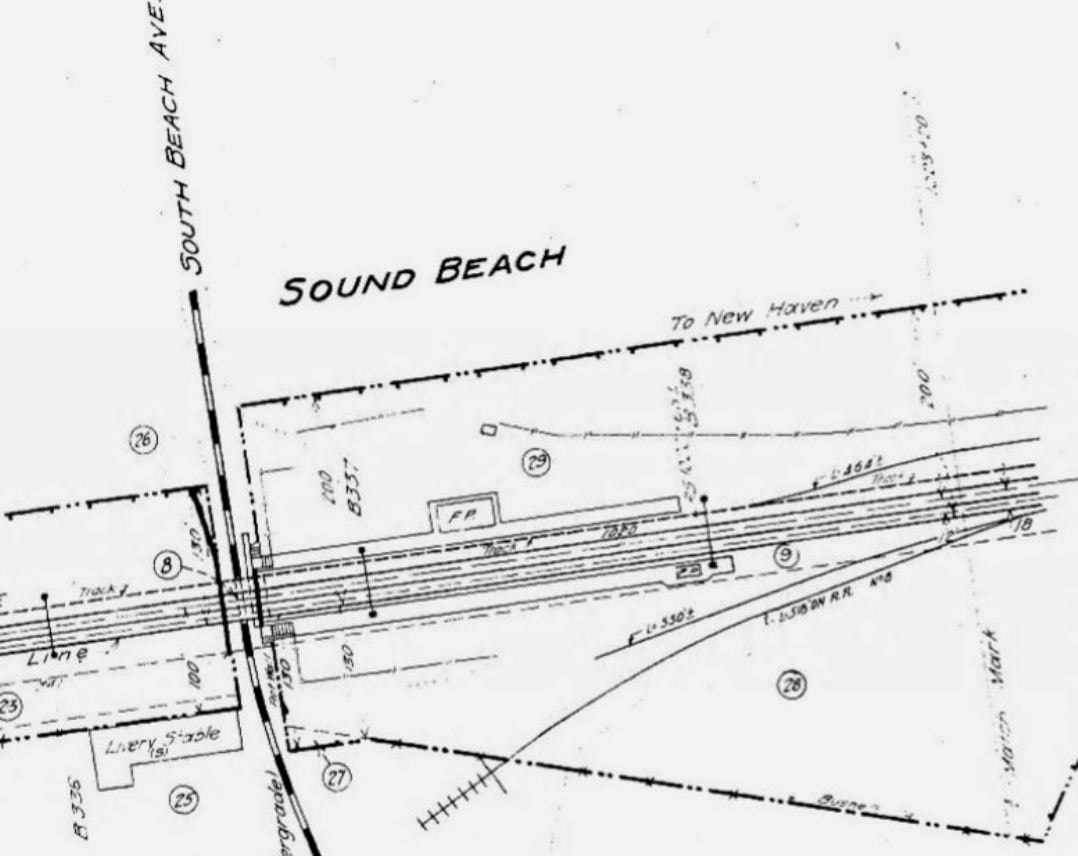
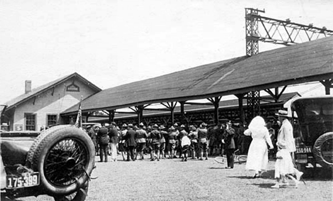
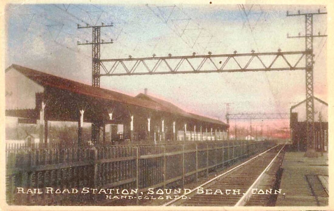
SOUND BEACH2 [NYNH&H, 1892, WB]
The NYNH&H replaced the burned-out depot with a new one on the same site north of the tracks. This building was constructed in the saltbox style that was popular with the Consolidated at the time. At 26x71 feet, this was likely a much larger station than others of the style. In an 1893 article there are some interesting comments about post offices in depots, wherein it says the postmaster was also the station-agent, express-agent, telegraph-operator, ticket-seller and bureau of information! Quite a busy guy, as all stationmasters were, and that does not even speak of freight duties, hopefully performed by another agent. In terms of politics, it said that here and at RIVERSIDE the post offices were in the stations and the agent-postmasters, were both Republican at that time and the only way to get a Democratic postmaster was to have a Democratic station agent. But, it continues, the railroad disregarded politics when it chose its stationmasters. This implies that the usual appointment by the Post Office, often patently politically-based on the party in power, was not in play with station agents who also were postmasters. See MERWINSVILLE for an interesting contradiction to this assertion and we will let it rest there for now. In 1899 a baggagemaster was named as being transferred here from New Haven. Most stations of any size seem to have had one and by 1911 even an assistant baggagemaster is mentioned. On 7/28/1989 SOUND BEACH2 received an NRHP designation which said "... Although the platform has been modernized, Sound Beach Station's plain form, restrained Victorian ornament, overhanging roof, baggage doors, and highly original interior make it a significant example of small-town station architecture. Restored after an arson fire on 8/19/2002, it continues to serve Metro-North customers in 2022.
IMAGES: [1] 10/16/1926 ICC valuation photo; [2] 6/30/1915 ICC valuation map showing trolley tracks on Sound Beach Ave; [3] Doughboys gather, possibly for 11/26/1917 encampment at nearby Innis Arden estate, now a golf club; [4] 1924 0821 postmarked card. Westernmost edge of platform visible at right. Note trolley tracks, also seen on val map; [5] 1960s northeast view; [6] southwest view after high-level platforms installed by May, 1974. [7] 12/6/1913 tracing has 1892 as the correct build date. [REFS: SAD/03/13/1893/01; NHER/03/22/1899/10; SAD/01/23/1900/01: both stations, separate post offices robbed; HC/01/23/1975/68: firefighter arson on 1/15; HC/05/23/1974/95B; NRIS (National Register Information System) ID: 89000929, nomination form p8.2; R80][rev053122, 050323]

|
|
|
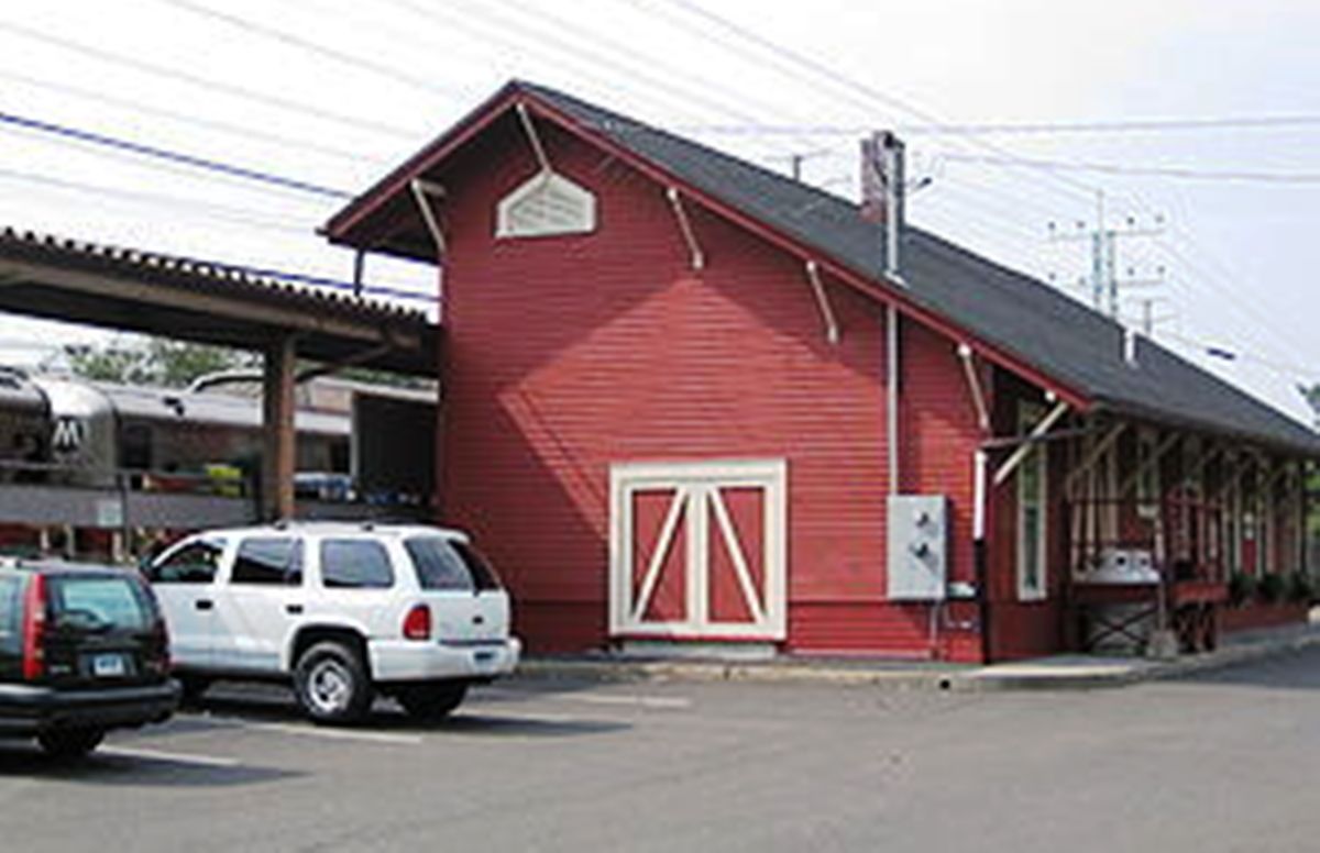
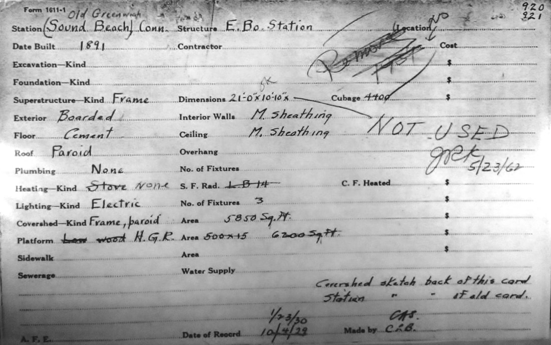
SOUND BEACH3 [NYNH&H, 1897, EB]
A real estate card erroneously dates this structure to 1891 when in reality it was put up with the great four-tracking and elevation project on the New York Division in progress here from 1895 to 1897. The card does give plausible dimensions as approximately 11x21 feet. From the 1890s this enclave had burgeoned. There was such a vibrant community and camaraderie between here and RIVERSIDE that secession from Greenwich was considered in 1907! By the 1920s the joint area was considered important enough to merit a Sound Beach-Riverside 'city' directory. Sizeable Sound Beach newspaper columns in the Stamford Advocate report churches, a school, civic groups, a baseball team, a fire station, a one-man police force, and a National Guard unit, not to mention a thriving hospitality industry. Freight handled here included lobster -- half a million harvested in 1895 -- and crops grown in fertile soil; a carload of fruit is noted at the station in 1911. The stop would be renamed OLD GREENWICH on 4/26/1931 at the request of the garden club ladies who were split on the issue. The side that wanted to change to the 'more historic name' which was unhistorical after a half century, were accused of elitism insomuch as they wanted "... 'to discourage the idea of bathing' meaning of course, public bathing, and 'affect the sophistication which attaches to the name of Greenwich.'" "... Homes, it seems, were disrupted and husbands insulted wives or vice versa." The names of 800 'Old Greenwichers' attached to a petition to the railroad and the Post Office Department resulted in the change. The dilapidated condition of both stations led the New York Times to say in 1964 "... This town's four dingy, peeling railroad stations... looked more like Dogpatch than fashionable Greenwich." The financially strapped New Haven applied to the PUC to tear down the eastbound stations here and at RIVERSIDE and COS COB. The PUC refused and told the railroad to renovate them, saying that "... Late trains are a 'common occurrence' on the New Haven... and on such occasions 'existing shelters serve an essential purpose in shielding the public from rain, snow, sleet and wind.'" While no exact date has yet been found for the demolition of SOUND BEACH3, we surmise that it was done in 1974 with the installation of the high-level platforms. IMAGES: [1] ca 1954 view; [2] ca. 1910 postcard looking west, SOUND BEACH3 on left; [3] 1962 'not used' on real estate card, meaning is unclear; [4] 1922-1923 directory.
[REFS: NHER/01/27/1892/03; SCIAM/02/26/1895/60: lobsters; NHER/01/23/1900/03; HC/01/24/1900/03; SAD/08/29/1911 /03; NYT/02/17/1907/12; NYT/04/26/1931/N3; NYT/01/23/1994/33; Warmsley: post office name change 7/31/1931][rev053122, 050323]
|
|
|
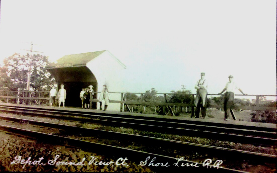
SOUND VIEW1 [NYNH&H, 1903]
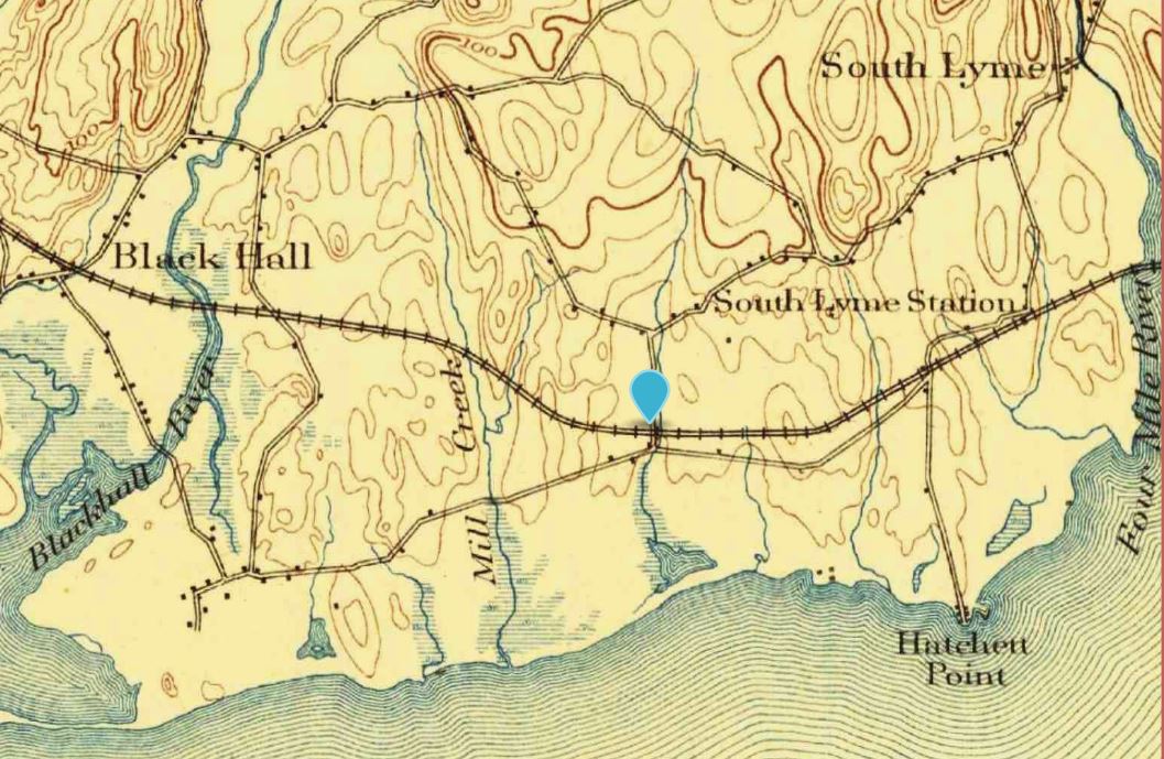
The Springfield Republican newspaper said in July 1903 that a flag station had "recently been established here" in the town of Old Lyme. By 1907 this was said to be a thriving beach community with six telephones, the post office moved out of the grocery store to its own quarters, and a handsome Roman Catholic chapel raised by Hartford cottagers. A common focus was the urgent desire for "a full-fledged, life-sized railroad station" to replace the current one, presumably seen at [1]. Additional comments said that "the [present] shed that marks the jumping-off place at Sound View would be scorned as a trolley waiting station on a branch road. You can't buy a ticket there; neither can you check baggage, all probably because the New York, New Haven & Hartford Railroad doesn't realize the advance steps this place has been making. About one train out of three stops at Sound View coming from New London. The conductors actually get 'riled' when asked does the train stop there." With the imminent closing of the BLACK HALL station just west, to be combined with LYME [see LYME3], word was that "Sound View stock will leap several points and property will increase in value greatly." These communities were tightly knit and in both camaraderie and competition with their neighbors in between clambakes and baseball games. Many gathered around their religious affiliations and constructed chapels for Sunday services. Seasonally the railroad stations like this one and even the post offices would close if year-round service was not called for. The street-side view at [2] looks north is from a card postmarked 7/24/1910. It shows the overpass just east of the station for the road known today as Cross Lane. The 1893 topo map at [3] shows BLACK HALL and SOUTH LYME but no SOUND VIEW, a geographical point which did not exist before the establishment of the station here in 1903. [REFS: SR/07/05/1903/13; HC/07/22/1905/14; HC/07/12/1907/13][rev100118, 091122, 012122]
The Springfield Republican newspaper said in July 1903 that a flag station had "recently been established here" in the town of Old Lyme. By 1907 this was said to be a thriving beach community with six telephones, the post office moved out of the grocery store to its own quarters, and a handsome Roman Catholic chapel raised by Hartford cottagers. A common focus was the urgent desire for "a full-fledged, life-sized railroad station" to replace the current one, presumably seen at [1]. Additional comments said that "the [present] shed that marks the jumping-off place at Sound View would be scorned as a trolley waiting station on a branch road. You can't buy a ticket there; neither can you check baggage, all probably because the New York, New Haven & Hartford Railroad doesn't realize the advance steps this place has been making. About one train out of three stops at Sound View coming from New London. The conductors actually get 'riled' when asked does the train stop there." With the imminent closing of the BLACK HALL station just west, to be combined with LYME [see LYME3], word was that "Sound View stock will leap several points and property will increase in value greatly." These communities were tightly knit and in both camaraderie and competition with their neighbors in between clambakes and baseball games. Many gathered around their religious affiliations and constructed chapels for Sunday services. Seasonally the railroad stations like this one and even the post offices would close if year-round service was not called for. The street-side view at [2] looks north is from a card postmarked 7/24/1910. It shows the overpass just east of the station for the road known today as Cross Lane. The 1893 topo map at [3] shows BLACK HALL and SOUTH LYME but no SOUND VIEW, a geographical point which did not exist before the establishment of the station here in 1903. [REFS: SR/07/05/1903/13; HC/07/22/1905/14; HC/07/12/1907/13][rev100118, 091122, 012122]

|
|

|
|
|

|
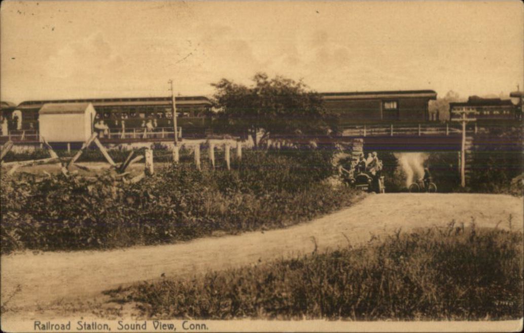
SOUND VIEW2 [NYNH&H, 1912]
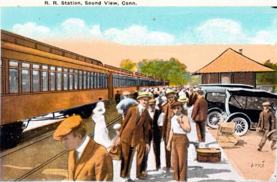
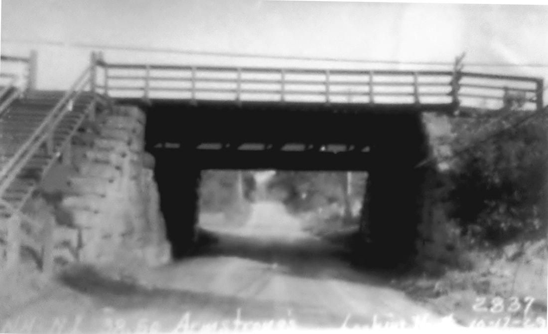
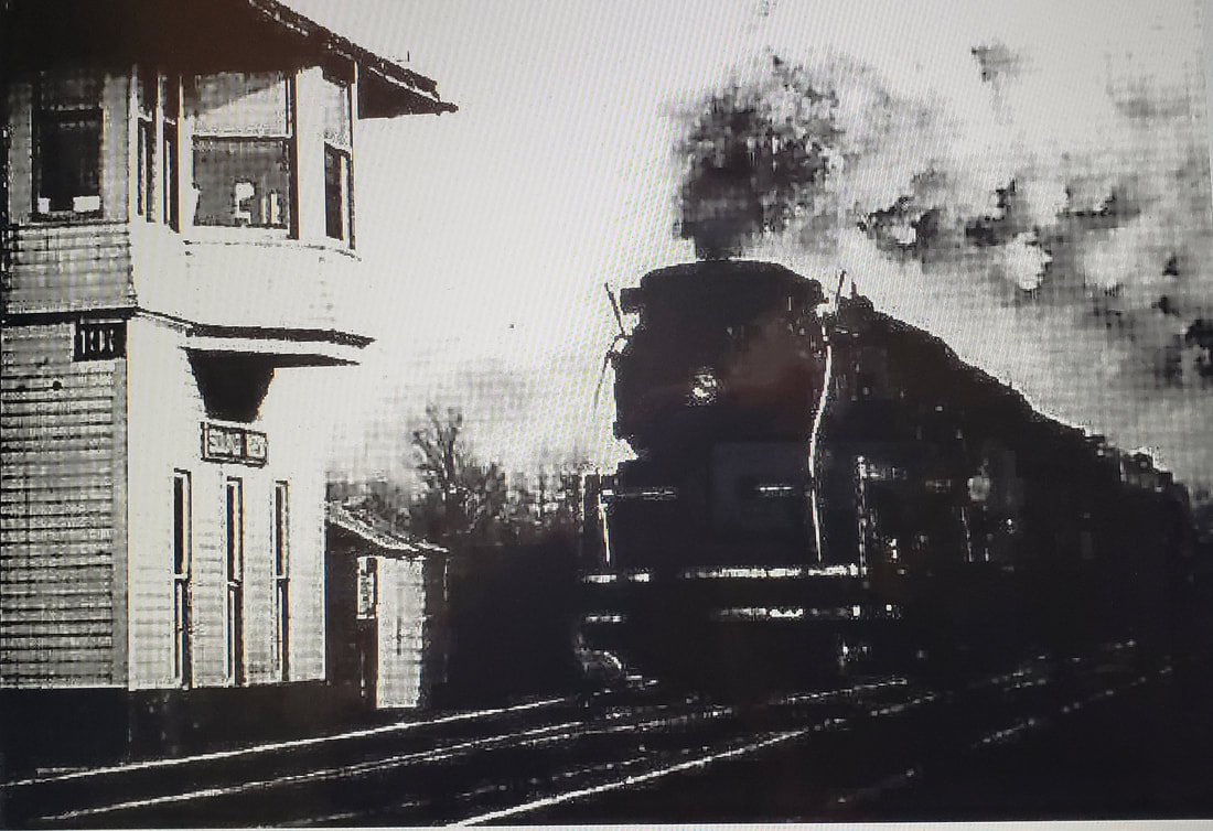
The 1912 season got off to a historic start when the newspaper said... "The first and most pleasing sight which reaches the eye of the arriving cottage owners is the new railroad station, situated on the other side [i.e. north] of the track, and opposite the old one. Although the grading and other preparations were started early last season, the building was not started until after all the cottagers had left. Tickets will now be sold here, a privilege which patrons up to this time had not enjoyed." In what appears to be a matched set, the image at [1] looks east and [2] looks west. You can almost feel the excitement at train time! The marked-up val map at [3] shows the location in more detail; Armstrong's Crossing is today's Cross Lane. Seasonal traffic began on Memorial Day and ended on Labor Day, more or less. A 1920 article makes it sound like the railroad based the station closings on a case by case basis; this one was already closed by 9/16 and Agent Harris was going to CRESCENT BEACH [see there] "until the visitors at that resort depart for their homes, probably another month." The image at [4] is a 10/17/1929 PUC shot which looks compass south but is noted as west for the Shore Line's railroad direction. At left it shows a set of stairs leading up to the platform on the north side of the track. With the Great Depression's impact on the prosperity of vacationers, these beach resort communities shrank in numbers and seasonal profitability for the railroad. The PUC heard a petition on 11/28/1932 at SOUND VIEW station on its proposed abandonment. In November, of course, perhaps according to railroad plan, year-round residents were not numerous enough to stave off the inevitable. Our 2/8/1932TT still lists SOUND VIEW but with no trains stopping there; the last season of service was likely 1931. The fate of the neat little station is unknown to us. It is not on the 1938 SSRR list and our assumption is therefore that it had been disposed of before that time. This stop wound up being more important to the railroad than just for passenger revenue. It was a convenient location with more available land for sidings than where it stood previously at SOUTH LYME2, a mile or so east, and thus a new tower was put into service here on 4/11/1917, the S.S. 106 designation being transferred. This was a more modern type of tower, larger, with more windows and a bay overhanging the track. The new tower is seen at [5] with an I-5 pulling a train likely during World War II. These locomotives were in use from 1937 to until about 1952, according to Charlie Dunn, and this was very busy spot during the war years with freights taking the siding here. The tower lasted until 1960, according to Bill Sample's NHRHTA list. The snippet at [6] shows the depot and tower locations on our Track 11 Google Earth map. The val photo at [7] is dated 9/8/1916 like ones taken at other nearby sites for ICC valuation purposes. [REFS: NHAR41.1912.10; HC/07/03/1912/19; NLD/03/10/1917/08; NMB/04/16/1917/06; NBU/09/16/1920/05; NBU/05/31/1921/05; NBU/06/02/1922/05; HC/10/20/1932/22; Status of Structures to be Retired and Removed, 1938: no; PC transfer of assets, 1/1/1969: no][rev100118, 012122]
The 1912 season got off to a historic start when the newspaper said... "The first and most pleasing sight which reaches the eye of the arriving cottage owners is the new railroad station, situated on the other side [i.e. north] of the track, and opposite the old one. Although the grading and other preparations were started early last season, the building was not started until after all the cottagers had left. Tickets will now be sold here, a privilege which patrons up to this time had not enjoyed." In what appears to be a matched set, the image at [1] looks east and [2] looks west. You can almost feel the excitement at train time! The marked-up val map at [3] shows the location in more detail; Armstrong's Crossing is today's Cross Lane. Seasonal traffic began on Memorial Day and ended on Labor Day, more or less. A 1920 article makes it sound like the railroad based the station closings on a case by case basis; this one was already closed by 9/16 and Agent Harris was going to CRESCENT BEACH [see there] "until the visitors at that resort depart for their homes, probably another month." The image at [4] is a 10/17/1929 PUC shot which looks compass south but is noted as west for the Shore Line's railroad direction. At left it shows a set of stairs leading up to the platform on the north side of the track. With the Great Depression's impact on the prosperity of vacationers, these beach resort communities shrank in numbers and seasonal profitability for the railroad. The PUC heard a petition on 11/28/1932 at SOUND VIEW station on its proposed abandonment. In November, of course, perhaps according to railroad plan, year-round residents were not numerous enough to stave off the inevitable. Our 2/8/1932TT still lists SOUND VIEW but with no trains stopping there; the last season of service was likely 1931. The fate of the neat little station is unknown to us. It is not on the 1938 SSRR list and our assumption is therefore that it had been disposed of before that time. This stop wound up being more important to the railroad than just for passenger revenue. It was a convenient location with more available land for sidings than where it stood previously at SOUTH LYME2, a mile or so east, and thus a new tower was put into service here on 4/11/1917, the S.S. 106 designation being transferred. This was a more modern type of tower, larger, with more windows and a bay overhanging the track. The new tower is seen at [5] with an I-5 pulling a train likely during World War II. These locomotives were in use from 1937 to until about 1952, according to Charlie Dunn, and this was very busy spot during the war years with freights taking the siding here. The tower lasted until 1960, according to Bill Sample's NHRHTA list. The snippet at [6] shows the depot and tower locations on our Track 11 Google Earth map. The val photo at [7] is dated 9/8/1916 like ones taken at other nearby sites for ICC valuation purposes. [REFS: NHAR41.1912.10; HC/07/03/1912/19; NLD/03/10/1917/08; NMB/04/16/1917/06; NBU/09/16/1920/05; NBU/05/31/1921/05; NBU/06/02/1922/05; HC/10/20/1932/22; Status of Structures to be Retired and Removed, 1938: no; PC transfer of assets, 1/1/1969: no][rev100118, 012122]

|

|

|
SOUTH BRITAIN [NYNH&H, c1915]
This flag stop in the town of Southbury probably debuted around 1915. It was not on the list of stations when the NY&NE opened the extension to the Hudson River in 1881 and it is neither on their real estate maps for 1886, revised in some cases to 1889, nor on any of the system maps we have from 1889 to 1895. The newspaper in late in 1880 said of the stations in this town that the SOUTHBURY depot had been centrally positioned so as to serve that village, Woodbury and South Britain, but that the inconvenient location chosen "will probably discommode all of them." Rockey, writing in 1892, says the only stops in this town were POMPERAUG VALLEY, aka SOUTHBURY, and SOUTHFORD. The first mention of a depot here in any of the sources is in 1917 as a flag stop and it is still listed as such for four daily trains each way on our 1923 timetable, probably abandoned thereafter with the cutbacks of 1925. We have its location as being just north of I-84 at the Ichabod Rd. overpass. The 1915 val map shows the station standing on the south side of the track. If you look closely at both of these shots, you can see that there is no rear wall in this unusual shelter. Also noteworthy is the paddle mechanism that was raised to notify the train that there was a passenger waiting. [REFS: DN/11/24/1880/??; DN/12/01/1880/??; DN/07/27/1881/01; PTH418.1907.??: no; PTH1917: yes; D139; R2.782]
This flag stop in the town of Southbury probably debuted around 1915. It was not on the list of stations when the NY&NE opened the extension to the Hudson River in 1881 and it is neither on their real estate maps for 1886, revised in some cases to 1889, nor on any of the system maps we have from 1889 to 1895. The newspaper in late in 1880 said of the stations in this town that the SOUTHBURY depot had been centrally positioned so as to serve that village, Woodbury and South Britain, but that the inconvenient location chosen "will probably discommode all of them." Rockey, writing in 1892, says the only stops in this town were POMPERAUG VALLEY, aka SOUTHBURY, and SOUTHFORD. The first mention of a depot here in any of the sources is in 1917 as a flag stop and it is still listed as such for four daily trains each way on our 1923 timetable, probably abandoned thereafter with the cutbacks of 1925. We have its location as being just north of I-84 at the Ichabod Rd. overpass. The 1915 val map shows the station standing on the south side of the track. If you look closely at both of these shots, you can see that there is no rear wall in this unusual shelter. Also noteworthy is the paddle mechanism that was raised to notify the train that there was a passenger waiting. [REFS: DN/11/24/1880/??; DN/12/01/1880/??; DN/07/27/1881/01; PTH418.1907.??: no; PTH1917: yes; D139; R2.782]
SOUTH CHESTER [> CHESTER2]

|

|
|

|

|
Lee Carlson photo
|
SOUTH COVENTRY [NLW&P, 1850]
This stop was established in 1850 by the NLW&P. The location is seen on the 1857TC map at upper left and its image is found on the 1878 bird's-eye map at upper middle. The station is still extant as seen in the 2013 photo at right. [REFS: R90][rev041713]
This stop was established in 1850 by the NLW&P. The location is seen on the 1857TC map at upper left and its image is found on the 1878 bird's-eye map at upper middle. The station is still extant as seen in the 2013 photo at right. [REFS: R90][rev041713]
SOUTH KENT1 [HRR, c1860]
The HRR opened its line north of New Milford in 1842. Although there was a post office here from 1857 until 1864 and it was reestablished in 1872, there is no station on any HRR timetable we have seen. Like NORTH KENT, also unlisted, trains still may have picked up passengers here. The first mention of a railroad station is in Atwater's 1897 History of Kent [p100] wherein he says VanNess Chase, the storekeeper, "waves a red flag for trains to stop, but has no tickets to sell." Since Atwater claims the depot was the size of an umbrella(!), we have listed this entry for the first station. [rev041713]
The HRR opened its line north of New Milford in 1842. Although there was a post office here from 1857 until 1864 and it was reestablished in 1872, there is no station on any HRR timetable we have seen. Like NORTH KENT, also unlisted, trains still may have picked up passengers here. The first mention of a railroad station is in Atwater's 1897 History of Kent [p100] wherein he says VanNess Chase, the storekeeper, "waves a red flag for trains to stop, but has no tickets to sell." Since Atwater claims the depot was the size of an umbrella(!), we have listed this entry for the first station. [rev041713]

|

|

|
SOUTH KENT2 [NYNH&H, c1900?]
The 'pigtail' reference on the building behind the station goes back to the names this area was known by, including Hopson Corners, Pigtail Corners, and Bulls Bridge. Legend has it that the porcine name, favored by locals, came from an incident in which one feuding neighbor cut the tail off the pig of his enemy. Alternately, the name may have come from the irregular layout of the intersecting Bulls Bridge Rd. and today's Rte. 7. Regardless, the nearby South Kent School has used the 'against the world' rallying call and the student newspaper is The Pigtail even today [click here]. This station would subsequently be named LILY LAKE in 1913 and finally WOODROW the next year, due to a wreck in 1913 at NORTH KENT. The renaming was at the suggestion of the Public Utilities Commission, which said that too many KENT stations may have confused the engineer and caused the accident. According to Pete McLachlan, retired NYNH&H engineer, historian and photographer, the Lily name derived from the family who once owned nearby Hatch Pond. The LILY LAKE name, unpopular with local residents, would be changed to WOODROW with the printing of the next timetable (6/29/1914rev) in honor of the recently elected President Wilson. Interestingly, the Times reported that town of Kent in its entirety had voted for William Howard Taft over Wilson 94-86 in the 1912 election. The gentleman thumbing his nose is said to be Irving N. Drake who acted as chauffeur to famed railroad-station photographer Lewis H. Benton in the 1930s and the handwritten captioning at the bottom is Benton's style. While some have conjectured that Drake is showing displeasure at the renaming of this station, the name of which is not even visible here, it is more widely thought that the pair has gotten the bum's rush from the station agent. According to an online posting, the NHRR was allowed to close WOODROW in 1946 on condition that it stop trains when classes at South Kent School recessed or reconvened. [REFS: HDC/04/28/1859/02: Pigtail; CWN/12/27/1872/02; NYT/12/21/1913/01; HC/12/ 21/1913/21; D71][rev041614]
The 'pigtail' reference on the building behind the station goes back to the names this area was known by, including Hopson Corners, Pigtail Corners, and Bulls Bridge. Legend has it that the porcine name, favored by locals, came from an incident in which one feuding neighbor cut the tail off the pig of his enemy. Alternately, the name may have come from the irregular layout of the intersecting Bulls Bridge Rd. and today's Rte. 7. Regardless, the nearby South Kent School has used the 'against the world' rallying call and the student newspaper is The Pigtail even today [click here]. This station would subsequently be named LILY LAKE in 1913 and finally WOODROW the next year, due to a wreck in 1913 at NORTH KENT. The renaming was at the suggestion of the Public Utilities Commission, which said that too many KENT stations may have confused the engineer and caused the accident. According to Pete McLachlan, retired NYNH&H engineer, historian and photographer, the Lily name derived from the family who once owned nearby Hatch Pond. The LILY LAKE name, unpopular with local residents, would be changed to WOODROW with the printing of the next timetable (6/29/1914rev) in honor of the recently elected President Wilson. Interestingly, the Times reported that town of Kent in its entirety had voted for William Howard Taft over Wilson 94-86 in the 1912 election. The gentleman thumbing his nose is said to be Irving N. Drake who acted as chauffeur to famed railroad-station photographer Lewis H. Benton in the 1930s and the handwritten captioning at the bottom is Benton's style. While some have conjectured that Drake is showing displeasure at the renaming of this station, the name of which is not even visible here, it is more widely thought that the pair has gotten the bum's rush from the station agent. According to an online posting, the NHRR was allowed to close WOODROW in 1946 on condition that it stop trains when classes at South Kent School recessed or reconvened. [REFS: HDC/04/28/1859/02: Pigtail; CWN/12/27/1872/02; NYT/12/21/1913/01; HC/12/ 21/1913/21; D71][rev041614]
SOUTH KILLINGLY [> KILLINGLY]
|
|

|

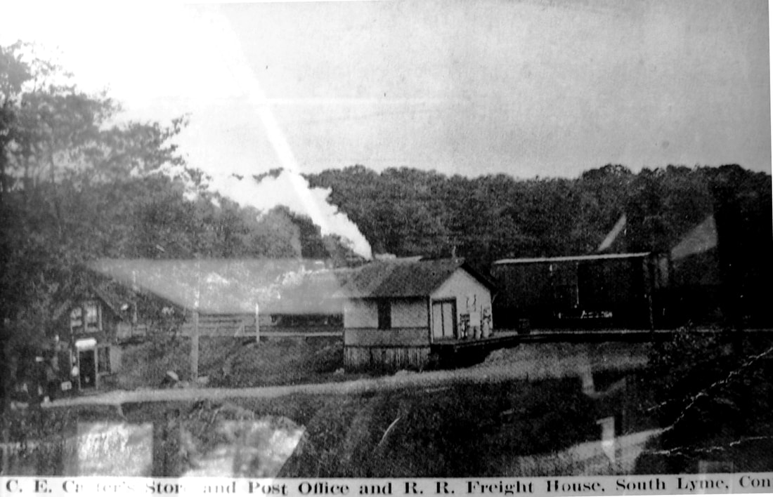
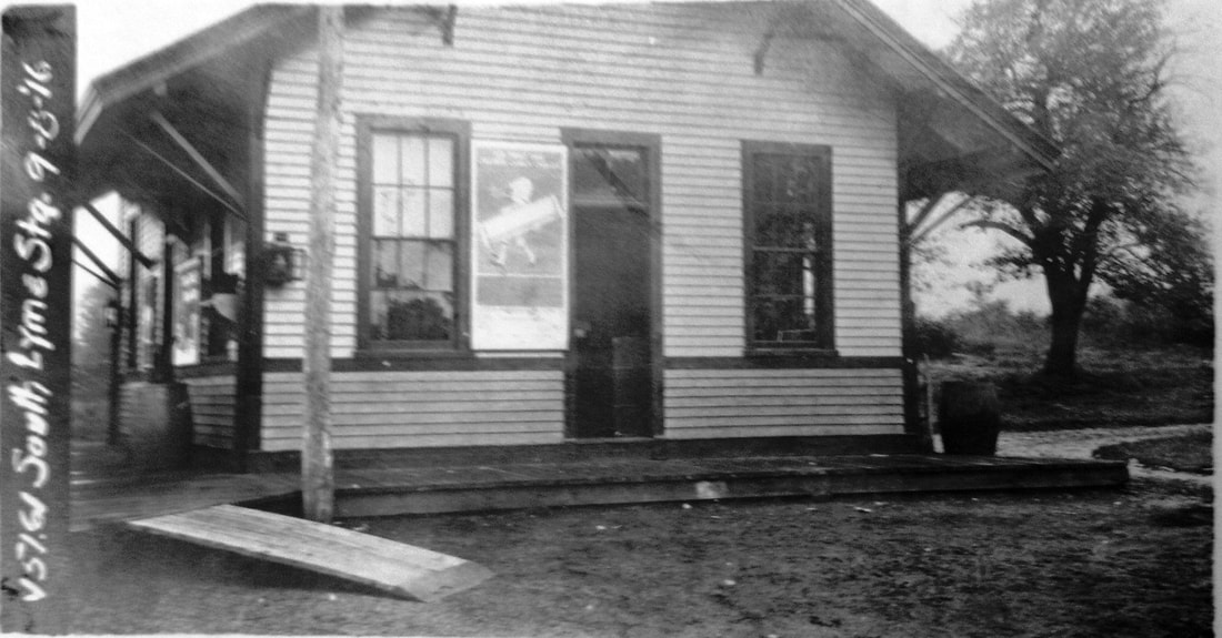
SOUTH LYME1 [NH&NL, 1852]
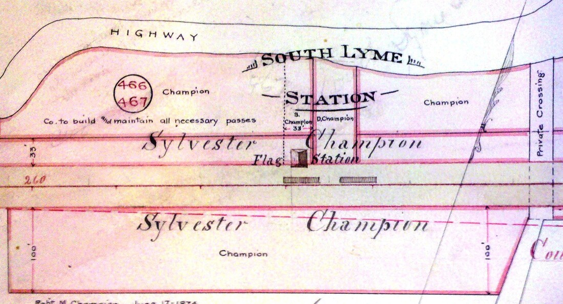
This station was in the town of Old Lyme and appears to have been established when the line was opened in 1852 by the NH&NL. We think the diminutive building in the center of [1] was the first depot here. A locomotive, steam blasting skyward, and a box car are fairly visible in this poor quality image, the best we have, likely taken at a time when this structure was in use as the freight house after its successor was built in 1895. The view looks south at the depot which stood north of the track. To the left is the Carrier general store with the post office located therein at that time. The Carrier name looms large on the Index Map at [2] which likely dates to 1872. The footprint of the structure, perhaps 16x20 feet, and the perpendicular orientation to the track seem to be corroborated. The 9/8/1916 photo at [4], the day verified in the next listing, shows the building now definitely turned parallel to the track and a platform loaded with freight. The end-of-season date may have something to do with that amount of shipping from here. The 1855 Colton map at [3] shows that this station was established at least by then. The history of the Lymes is somewhat convoluted but the towns we know today as Lyme, Old Lyme and East Lyme were all once part of the East Saybrook Plantation and were gradually split off. The confusion of names reached a comic point as reflected in an 1872 article that said when an office boy in town was "... sorting the packages to be mailed, he came across Lyme, East Lyme, North Lyme, South Lyme, Old Lyme and two or three other Lymes, he thought the next Lyme should be Slack Lyme." [REFS: Geer's Express Directory, 1858: yes; NA/11/15/1872/03; NHER/11/22/1878/04][rev012022]
This station was in the town of Old Lyme and appears to have been established when the line was opened in 1852 by the NH&NL. We think the diminutive building in the center of [1] was the first depot here. A locomotive, steam blasting skyward, and a box car are fairly visible in this poor quality image, the best we have, likely taken at a time when this structure was in use as the freight house after its successor was built in 1895. The view looks south at the depot which stood north of the track. To the left is the Carrier general store with the post office located therein at that time. The Carrier name looms large on the Index Map at [2] which likely dates to 1872. The footprint of the structure, perhaps 16x20 feet, and the perpendicular orientation to the track seem to be corroborated. The 9/8/1916 photo at [4], the day verified in the next listing, shows the building now definitely turned parallel to the track and a platform loaded with freight. The end-of-season date may have something to do with that amount of shipping from here. The 1855 Colton map at [3] shows that this station was established at least by then. The history of the Lymes is somewhat convoluted but the towns we know today as Lyme, Old Lyme and East Lyme were all once part of the East Saybrook Plantation and were gradually split off. The confusion of names reached a comic point as reflected in an 1872 article that said when an office boy in town was "... sorting the packages to be mailed, he came across Lyme, East Lyme, North Lyme, South Lyme, Old Lyme and two or three other Lymes, he thought the next Lyme should be Slack Lyme." [REFS: Geer's Express Directory, 1858: yes; NA/11/15/1872/03; NHER/11/22/1878/04][rev012022]
|
|
National Archives
|
National Archives
|
|
|
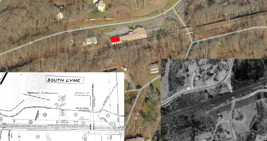
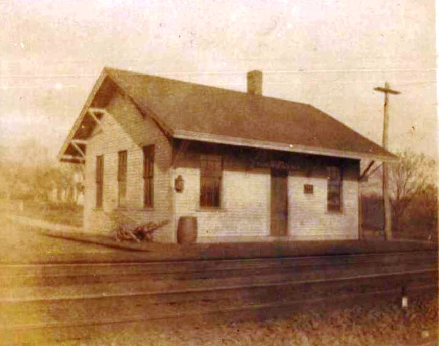
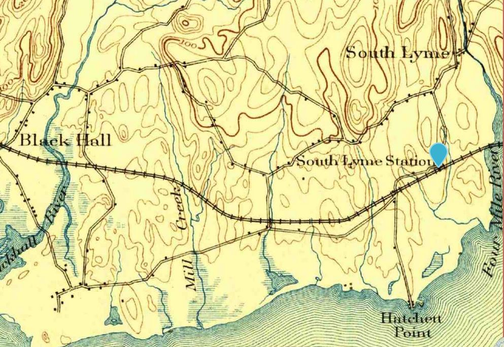
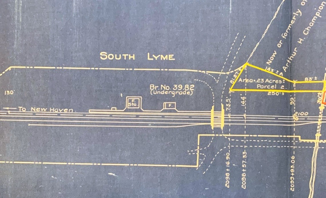
SOUTH LYME2 [NYNH&H, 1895]
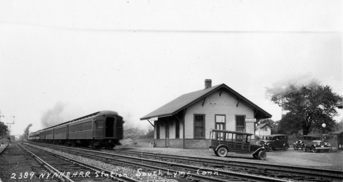
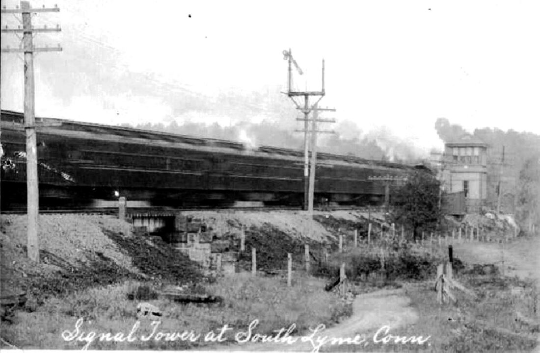
The railroad commissioners report that a new depot was built here in 1895. This structure was located just to the west of the first station. Surpisingly no newspaper articles have been found. The undated view at [1] is taken from a circa 1907 postcard. The 1893 topo map at [2] shows the location. The ICC valuation photo at [3] is dated 9/8/1916. The val map at [4] shows the layout in August, 1925, marked up for a real estate transaction. The original maps date to 6/30/1915 and were subsequently used by the railroad for property management purposes. The private under-crossing eventually became today's Shore Acres Rd. after the Point O' Woods resort community was developed in 1918. Note that the station platform seems to extend to the end of the overpass bridge. The image at [5] is Lewis H. Benton's #2389 taken in June, 1929. Fellow photographer and duo 'chauffeur' Irving N. Drake is standing by his sedan, the vehicle second from right. We also note that the sign on the depot says the post office was here at that time. The rare view at [6] shows the 1893 South Lyme signal tower which was replaced in 1917 by a more modern structure at Sound View, a mile or so west, the S.S. 106 designation transferred there. The passenger station depot reportedly closed permanently in 1927. It stood at least until 1938 when the SSRR list says it was being leased for $204 per year and the freight house was rented as well. Further fate is yet unknown to us. Al Weaver's masterful superimposition at [7] tells the whole story here, with the 1915 val map [left] and the 1934 aerial [right] shown on today's map. We have added the red arrow to show the location of S.S. 106 before it was moved to SOUND VIEW. [REFS: CRC43.1895.13; NMB/04/16/1917/06; Status of Stations to be Retired and Removed, 1938: yes, leased; HC/07/08/1970/30F][rev010518; 012122]

|
|

|

|

|

|
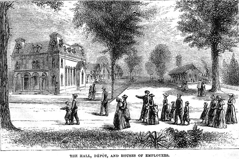
SOUTH MANCHESTER [SM, 1869]
This station is seen on the 1880 Bailey map at lower left [click here], appropriately located amidst the silk-mill buildings of the Cheney family, which paid for the 2.25-mile South Manchester RR to bring trains to its door. Upon completion in June, 1869, the road was sold to the HP&F but bought back by the Cheneys in 1879 when they were dissatisfied with the service the successor NY&NE was providing. The woodcut at upper middle from Harper's New Monthly of November, 1872, shows the depot standing in a rather idyllic setting at that time. In 1889, plans were drawn up for a new brick depot at Elm and Park Sts., one purpose of which was to eliminate the Forest St. grade crossing, but the new structure was never built. The safety issue was not addressed until 20 years later when the old depot was moved about 1,000 feet north to just above Forest St., an action approved on 10/22/1910 by the railroad commissioners. The 1893 map [lower middle] shows the original location and the 1914 Hughes and Bailey map [lower right] shows it moved farther north. The last passenger SMRR passenger train ran on 1/26/1933 as a condition for the line to be absorbed by the NYNH&H and the freight-only line survived through Penn Central in 1969 and ended when Conrail took over in 1976. Apparently, Cheney Bros., which never recovered from the hard times of the 1930s, had retained possession of the depot because, when marshalling their remaining assets in 1955, a Courant article reported that "the old depot of the South Manchester Railroad Co. on Forest Street at Cheney Bros., which for the past 20 years has been used as a diner, will cease to be used for that purpose, it was learned Friday. The present operator of the diner and lunch room, George Aftomis had disclosed that he has received notification from Cheney Bros. that 'your lease with the company was cancelled as of March 15... and that it will be necessary for you to be out of the premises not later than March 15.'" Aftomis had operated the diner as 'George's Lunch' for about seven years and before him Walter Mahoney, a former Cheney employee had done the same. According to Lewis [SAS], the station would serve briefly as headquarters for the local Socialist Party before being torn down later in 1955. Ed Ozog comments that the photo at upper middle shows a train pulled by SMRR 2-4-4T #3. [REFS: HDC/05/22/1869/02; HDC/06/29/1869/02; HC/08/05/1889/06; CRC49.1901.24; CRC58.1910.14; HC/09/30/1910/17; HC/10/25/1910/07; HC/03/12/1955/6B; HC/10/09/1981/C9; SAS p24,27][rev090213]
This station is seen on the 1880 Bailey map at lower left [click here], appropriately located amidst the silk-mill buildings of the Cheney family, which paid for the 2.25-mile South Manchester RR to bring trains to its door. Upon completion in June, 1869, the road was sold to the HP&F but bought back by the Cheneys in 1879 when they were dissatisfied with the service the successor NY&NE was providing. The woodcut at upper middle from Harper's New Monthly of November, 1872, shows the depot standing in a rather idyllic setting at that time. In 1889, plans were drawn up for a new brick depot at Elm and Park Sts., one purpose of which was to eliminate the Forest St. grade crossing, but the new structure was never built. The safety issue was not addressed until 20 years later when the old depot was moved about 1,000 feet north to just above Forest St., an action approved on 10/22/1910 by the railroad commissioners. The 1893 map [lower middle] shows the original location and the 1914 Hughes and Bailey map [lower right] shows it moved farther north. The last passenger SMRR passenger train ran on 1/26/1933 as a condition for the line to be absorbed by the NYNH&H and the freight-only line survived through Penn Central in 1969 and ended when Conrail took over in 1976. Apparently, Cheney Bros., which never recovered from the hard times of the 1930s, had retained possession of the depot because, when marshalling their remaining assets in 1955, a Courant article reported that "the old depot of the South Manchester Railroad Co. on Forest Street at Cheney Bros., which for the past 20 years has been used as a diner, will cease to be used for that purpose, it was learned Friday. The present operator of the diner and lunch room, George Aftomis had disclosed that he has received notification from Cheney Bros. that 'your lease with the company was cancelled as of March 15... and that it will be necessary for you to be out of the premises not later than March 15.'" Aftomis had operated the diner as 'George's Lunch' for about seven years and before him Walter Mahoney, a former Cheney employee had done the same. According to Lewis [SAS], the station would serve briefly as headquarters for the local Socialist Party before being torn down later in 1955. Ed Ozog comments that the photo at upper middle shows a train pulled by SMRR 2-4-4T #3. [REFS: HDC/05/22/1869/02; HDC/06/29/1869/02; HC/08/05/1889/06; CRC49.1901.24; CRC58.1910.14; HC/09/30/1910/17; HC/10/25/1910/07; HC/03/12/1955/6B; HC/10/09/1981/C9; SAS p24,27][rev090213]
SOUTH NORFOLK [> GRANTS]
SOUTH NORWALK [> NORWALK]
SOUTH NORWALK [> NORWALK]
SOUTH STREET1 [WL&S, 1870]
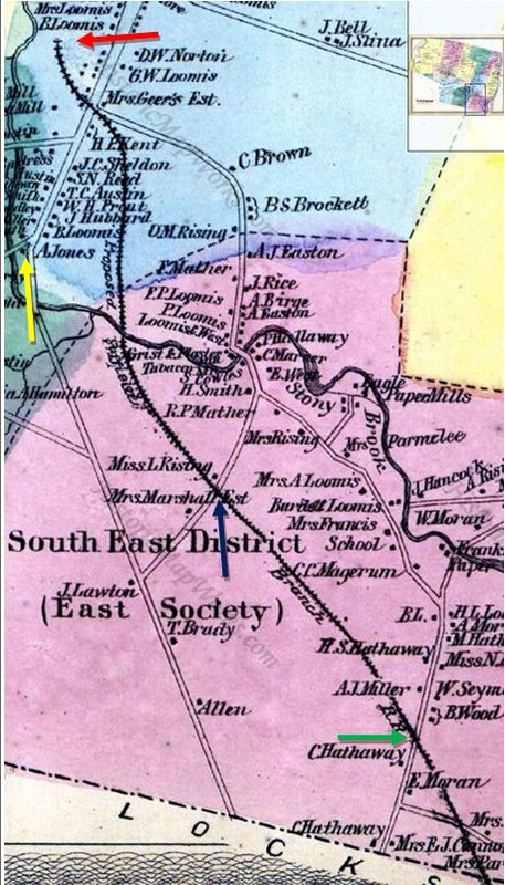
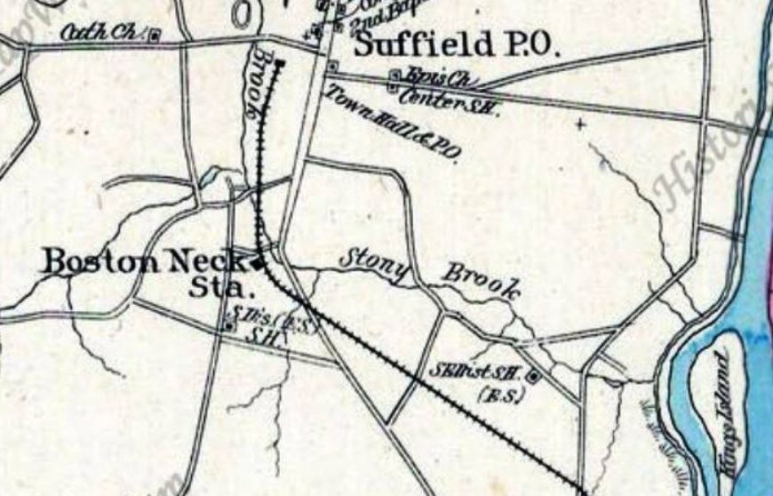
According to an article in the Springfield Republican, this as well as BOSTON NECK (purple arrow) and WOODS (green arrow) were original stops on the branch that opened to SUFFIELD (red arrow) on 12/12/1870, all in the town of the latter name. The 1869 Baker and Tilden map at left shows the proposed line the year before it was built by Windsor Locks and Suffield RR. It had the backing of H&NH and a contribution of $25,000 from Suffield, an investment the town never regretted according to one history. This was catch-up for a Suffield after it rejected the railroad in 1844 and forced the H&S to go across the Connecticut River from Windsor Locks to Enfield. As built, the WL&S line swung more to the west so that the SOUTH STREET1 stop was at the yellow arrow. Judging by the tenor of the article in our next entry, there may have only been a platform here, if even that, until the "long-sought station" arrived in 1890. It is hard to imagine that the H&NH provided no facility here for 20 years so we have retained this listing to account for this stop. [REFS: SR/12/12/1870/08; Memorial History of Hartford County, p407][rev111914]
According to an article in the Springfield Republican, this as well as BOSTON NECK (purple arrow) and WOODS (green arrow) were original stops on the branch that opened to SUFFIELD (red arrow) on 12/12/1870, all in the town of the latter name. The 1869 Baker and Tilden map at left shows the proposed line the year before it was built by Windsor Locks and Suffield RR. It had the backing of H&NH and a contribution of $25,000 from Suffield, an investment the town never regretted according to one history. This was catch-up for a Suffield after it rejected the railroad in 1844 and forced the H&S to go across the Connecticut River from Windsor Locks to Enfield. As built, the WL&S line swung more to the west so that the SOUTH STREET1 stop was at the yellow arrow. Judging by the tenor of the article in our next entry, there may have only been a platform here, if even that, until the "long-sought station" arrived in 1890. It is hard to imagine that the H&NH provided no facility here for 20 years so we have retained this listing to account for this stop. [REFS: SR/12/12/1870/08; Memorial History of Hartford County, p407][rev111914]
SOUTH STREET2 [NYNH&H, 1890]
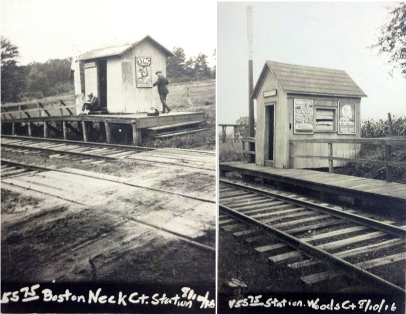
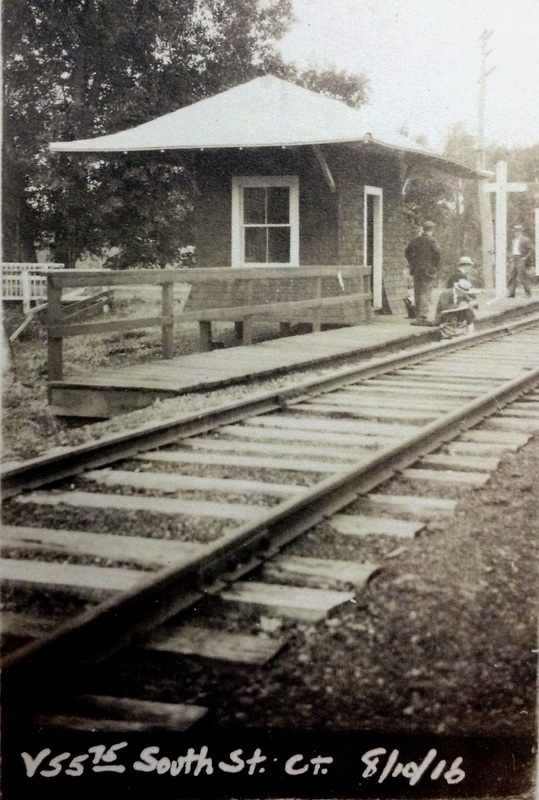
A newspaper article from January, 1890 says "The long looked-for building at the South street station is now being erected. It is 10x16 feet more commodious [sic] than those at Boston Neck and Wood's Station. It will be appreciated by all persons taking the train or getting off at this station." Though unclear, the article seems to indicate that the new depot was 10x16 and that its size was larger than either of the other two stations on the line, both seen in the 9/10/1916 composite image at left. Since the article does not mention the style of the depot and we have no photo, it would be unwise to speculate beyond that it was likely a small shelter along the lines of these two. The fate of whatever structure stood here as SOUTH STREET2 is unknown. [REFS: HWT/01/23/1890/03; SR/04/04/1911/16; HC/03/26/1914/ 11][add111914]
A newspaper article from January, 1890 says "The long looked-for building at the South street station is now being erected. It is 10x16 feet more commodious [sic] than those at Boston Neck and Wood's Station. It will be appreciated by all persons taking the train or getting off at this station." Though unclear, the article seems to indicate that the new depot was 10x16 and that its size was larger than either of the other two stations on the line, both seen in the 9/10/1916 composite image at left. Since the article does not mention the style of the depot and we have no photo, it would be unwise to speculate beyond that it was likely a small shelter along the lines of these two. The fate of whatever structure stood here as SOUTH STREET2 is unknown. [REFS: HWT/01/23/1890/03; SR/04/04/1911/16; HC/03/26/1914/ 11][add111914]

|
Max Miller Collection
|
|
 National Archives
SOUTH STREET3 [NYNH&H, 1915/16]
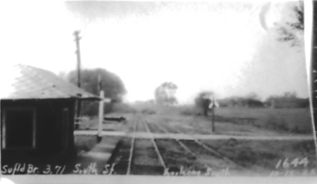
The 1915 val map at [1] and the 1920s PUC photo at [2] show the station in the northeast quadrant of the grade crossing at South St., Rte. 75 today. The 1893 Hurd map at [3] shows the location correctly but labels it BOSTON NECK. The NYNH&H annual report dated 6/30/1916 says a new station had been built here since the last report. The ICC val photo at [4] is dated 8/10/1916 which proves that this is the replacement structure, dissimilar in style from the older depots on the line. Passenger trains ended on 1/23/1926 after 55 years service and even the trolley line which was largely responsible for the demise was replaced by motor buses that started at SUFFIELD station, came here and then went to Hartford via East Granby. [REFS: NHAR45.1916.10; SR/12/10/1920/10; SR/08/01/1921/05; SR/01/17/1926/02][rev111914]
The 1915 val map at [1] and the 1920s PUC photo at [2] show the station in the northeast quadrant of the grade crossing at South St., Rte. 75 today. The 1893 Hurd map at [3] shows the location correctly but labels it BOSTON NECK. The NYNH&H annual report dated 6/30/1916 says a new station had been built here since the last report. The ICC val photo at [4] is dated 8/10/1916 which proves that this is the replacement structure, dissimilar in style from the older depots on the line. Passenger trains ended on 1/23/1926 after 55 years service and even the trolley line which was largely responsible for the demise was replaced by motor buses that started at SUFFIELD station, came here and then went to Hartford via East Granby. [REFS: NHAR45.1916.10; SR/12/10/1920/10; SR/08/01/1921/05; SR/01/17/1926/02][rev111914]
Dave Peters Collection
|

|
SOUTH WETHERSFIELD [CV, 1872]
According to the Courant, this depot was being built by locals in 1872. [REFS: HDC/09/22/1872/04; HDC/12/04/1875/01: late night burglary; Memorial History of Hartford County, p482]
According to the Courant, this depot was being built by locals in 1872. [REFS: HDC/09/22/1872/04; HDC/12/04/1875/01: late night burglary; Memorial History of Hartford County, p482]
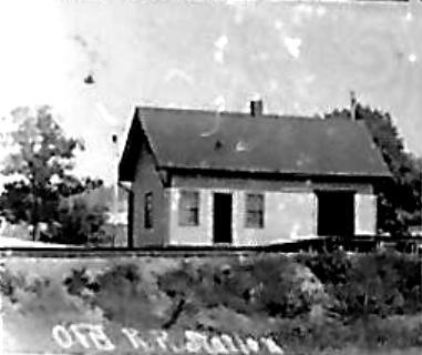
SOUTH WILLINGTON1 [NLN, 1850]
According to the Courant, this station burned in 1890 after the passage of the boat train that evening, even though everything had "appeared to be all right" The depot was described as being "a small inferior looking building" and it was hoped that the new one would be "more in keeping with that enterprising and growing village." [REFS: HC/09/06/1890/06]
According to the Courant, this station burned in 1890 after the passage of the boat train that evening, even though everything had "appeared to be all right" The depot was described as being "a small inferior looking building" and it was hoped that the new one would be "more in keeping with that enterprising and growing village." [REFS: HC/09/06/1890/06]
|

|
|
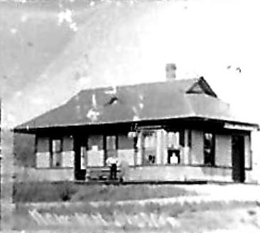
SOUTH WILLINGTON2 [CVT, 1890/1891]
Presumably built in late 1890 or early 1891 after the first station burned.
Presumably built in late 1890 or early 1891 after the first station burned.
|
|

|

|

|

|
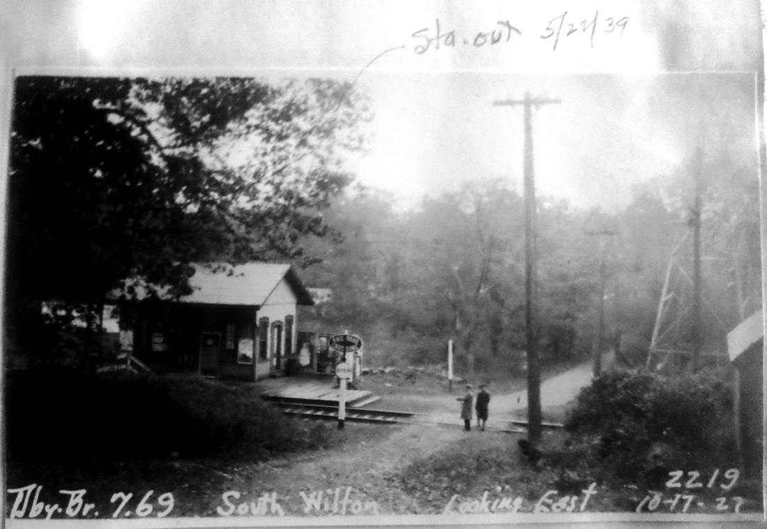
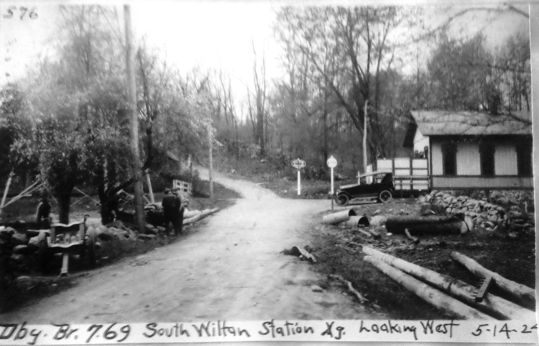
SOUTH WILTON [D&N, 1852; opened as KENT]
This was an original D&N stop from 1852 and is seen as KENT on the 1868 map at lower left. According to the reference work, Connecticut Place Names, Kent was a popular surname in the Norwalk River valley and it dated back to 1699 for a resident living nearby. The structure seen in all the photos may well be the one that dated back to 1852. The name was later changed to SOUTH WILTON probably in 1886 with the lease of the D&N by the HRR, likely to avoid confusion with its station in the town of Kent. Cornwall [p88] has an employee timetable from April, 1933 that shows this station called HOPKINS. The only attribution we can find for this later name is its "use by R.R. men c. 1914 as the name of S. Wilton," again in CPN. Public timetables we have from 1889 to 1956 show SOUTH WILTON exclusively. Service here was by bus increasingly until it took over completely by the latter date. There is no listing at all for this stop on a 1971TT in Cornwall [p94] but he says it reappeared nearby in 1976 as KENT ROAD. The two upper photos are from PUC inspections, with the subsequent notation on the one on the left that this station building was 'out' as of 5/22/1939. The 1938 SSRR list shows it had been sold as of that year for $25. The 1915 val map at lower right shows the station in the northeast quadrant of the crossing. [REFS: DC/09/03/1872/02; CPN, p679; P17,32,45,68,78,88,94,103c; SL17.1.10][rev010518]
This was an original D&N stop from 1852 and is seen as KENT on the 1868 map at lower left. According to the reference work, Connecticut Place Names, Kent was a popular surname in the Norwalk River valley and it dated back to 1699 for a resident living nearby. The structure seen in all the photos may well be the one that dated back to 1852. The name was later changed to SOUTH WILTON probably in 1886 with the lease of the D&N by the HRR, likely to avoid confusion with its station in the town of Kent. Cornwall [p88] has an employee timetable from April, 1933 that shows this station called HOPKINS. The only attribution we can find for this later name is its "use by R.R. men c. 1914 as the name of S. Wilton," again in CPN. Public timetables we have from 1889 to 1956 show SOUTH WILTON exclusively. Service here was by bus increasingly until it took over completely by the latter date. There is no listing at all for this stop on a 1971TT in Cornwall [p94] but he says it reappeared nearby in 1976 as KENT ROAD. The two upper photos are from PUC inspections, with the subsequent notation on the one on the left that this station building was 'out' as of 5/22/1939. The 1938 SSRR list shows it had been sold as of that year for $25. The 1915 val map at lower right shows the station in the northeast quadrant of the crossing. [REFS: DC/09/03/1872/02; CPN, p679; P17,32,45,68,78,88,94,103c; SL17.1.10][rev010518]
|

|
Joseph Cerreto Collection
|

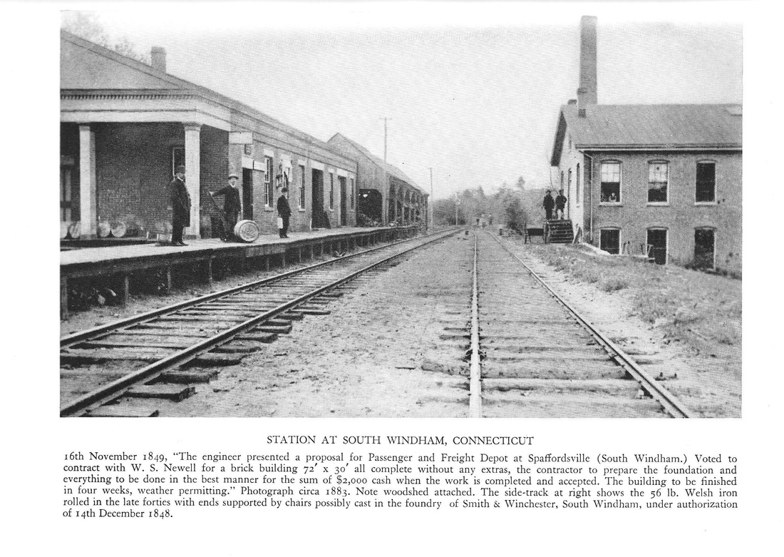
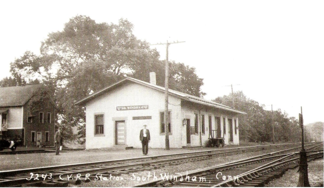
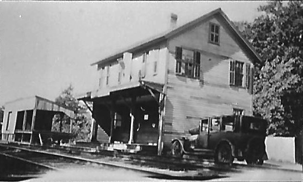
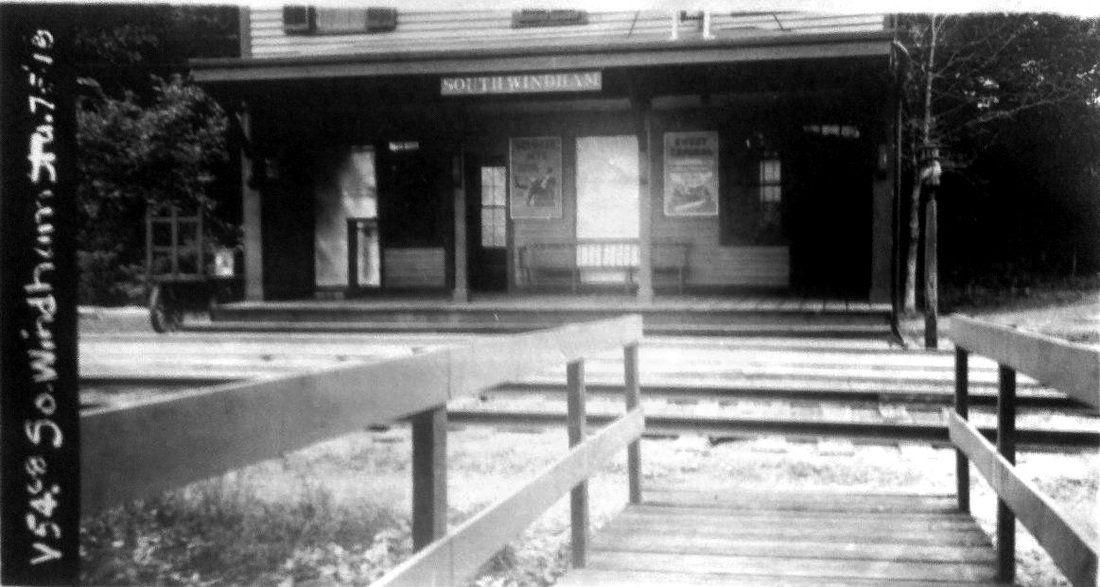
SOUTH WINDHAM/N [NLW&P, 1849]
The southern part of the town of Windham would have two railroads and two depots within a few years of the opening of the NLW&P in 1849. The photo at upper left appears in Woodward who says that the shot is ca. 1883 and that this 72x30-ft brick combination station with portico was authorized by the directors on 11/16/1849 and built by the end of that year. The middle picture with the water tank looks ca. 1900. The portico has come down and the wood shed beyond the station has also been removed. The captioning on the photo at right makes it a Lewis H. Benton 1930s shot, though that is not Drake posing and the touring car is not in sight either. Woodward also says this location was known as Spaffordsville. The map shows this depot highlighted at the left. The one at the right SOUTH WINDHAM2, the station for the HP&F, which had become the NY&NE by the time of this 1893 map. [REFS: R92; W32f][rev041713]
The southern part of the town of Windham would have two railroads and two depots within a few years of the opening of the NLW&P in 1849. The photo at upper left appears in Woodward who says that the shot is ca. 1883 and that this 72x30-ft brick combination station with portico was authorized by the directors on 11/16/1849 and built by the end of that year. The middle picture with the water tank looks ca. 1900. The portico has come down and the wood shed beyond the station has also been removed. The captioning on the photo at right makes it a Lewis H. Benton 1930s shot, though that is not Drake posing and the touring car is not in sight either. Woodward also says this location was known as Spaffordsville. The map shows this depot highlighted at the left. The one at the right SOUTH WINDHAM2, the station for the HP&F, which had become the NY&NE by the time of this 1893 map. [REFS: R92; W32f][rev041713]
|

|
|
SOUTH WINDHAM/H [HP&F, 1854]
This stop was established by the HP&F in 1854 but the two-story depot pictured here looks more like the 1880s: see PLAINFIELD/H2. The map shows this location north of the Shetucket River and also shows the NLW&P depot location south of the river. The 1938 SSRR list says both the station and platform were removed in 1938 at a sale price of $15, a figure which is hard to believe. [rev010518]
This stop was established by the HP&F in 1854 but the two-story depot pictured here looks more like the 1880s: see PLAINFIELD/H2. The map shows this location north of the Shetucket River and also shows the NLW&P depot location south of the river. The 1938 SSRR list says both the station and platform were removed in 1938 at a sale price of $15, a figure which is hard to believe. [rev010518]

SOUTH WINDSOR1 [CC, 1876]
This photo carries a ca. 1904 date in Phil Wooding's collection. Presumably, this was the station built when the CC opened in 1876 and established a stop here. This shot is sometimes seen mislabeled as EAST WINDSOR HILL. This station must be the one that burned, as related by the railroad commissioners in their 1910 annual report. One factor that helped place this photo here is the siding track running around the back of the depot. It is visible, again with a rail car or two, in the shots of SOUTH WINDSOR2 in our next entry. [REFS: CRC58.1910.28][rev022215]
This photo carries a ca. 1904 date in Phil Wooding's collection. Presumably, this was the station built when the CC opened in 1876 and established a stop here. This shot is sometimes seen mislabeled as EAST WINDSOR HILL. This station must be the one that burned, as related by the railroad commissioners in their 1910 annual report. One factor that helped place this photo here is the siding track running around the back of the depot. It is visible, again with a rail car or two, in the shots of SOUTH WINDSOR2 in our next entry. [REFS: CRC58.1910.28][rev022215]
|
|

|
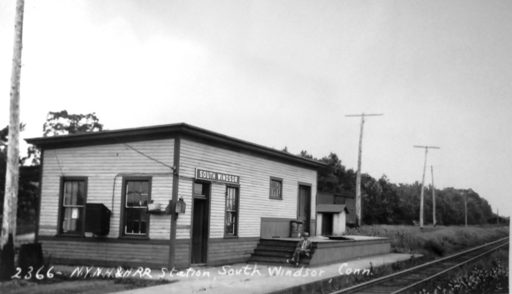
SOUTH WINDSOR2 [NYNH&H, 1910]
The railroad commissioners reported in December, 1910 that a new station had been built here to replace the one that had burned. The ca. 1930 Lewis H. Benton photo at left has Irving N. Drake sitting on the steps and his iconic sedan parked car out of sight. The PUC inspection photo at middle is dated 10/15/1925 and shows the depot in the northwest quadrant of the grade crossing. The 1915 val map at right shows the station area and the bow-shaped siding track around the back of the depot. [REFS: CRC58.1910.28; NHAR40.1911.11; HC/01/21/1915/17]
The railroad commissioners reported in December, 1910 that a new station had been built here to replace the one that had burned. The ca. 1930 Lewis H. Benton photo at left has Irving N. Drake sitting on the steps and his iconic sedan parked car out of sight. The PUC inspection photo at middle is dated 10/15/1925 and shows the depot in the northwest quadrant of the grade crossing. The 1915 val map at right shows the station area and the bow-shaped siding track around the back of the depot. [REFS: CRC58.1910.28; NHAR40.1911.11; HC/01/21/1915/17]
|

|

|
SOUTHBURY [NY&NE, 1881]
This was the name of this NY&NE station on opening and also appears as such on an 1889 system map. In the fashion of some stops, it had the alternate name of POMPERAUG VALLEY, and the two sometimes even appear in combination with each other. Both names, in fact, appear on a list of stations compiled by the state railroad commissioners themselves, with exactly the same 46.9 mileage point from Hartford! Multiple and similar-sounding names became the focus of Interstate Commerce Commission safety efforts for renaming stops in 1915 to avoid operational confusion. [REFS: NBE/11/17/1880/03: tin roof contract given; DN/07/27/1881/01; CRC30.1883.62; RAM99: both names; D138; SL29.1.8][rev041713, 042122]
This was the name of this NY&NE station on opening and also appears as such on an 1889 system map. In the fashion of some stops, it had the alternate name of POMPERAUG VALLEY, and the two sometimes even appear in combination with each other. Both names, in fact, appear on a list of stations compiled by the state railroad commissioners themselves, with exactly the same 46.9 mileage point from Hartford! Multiple and similar-sounding names became the focus of Interstate Commerce Commission safety efforts for renaming stops in 1915 to avoid operational confusion. [REFS: NBE/11/17/1880/03: tin roof contract given; DN/07/27/1881/01; CRC30.1883.62; RAM99: both names; D138; SL29.1.8][rev041713, 042122]

|

|
|
|

|
|
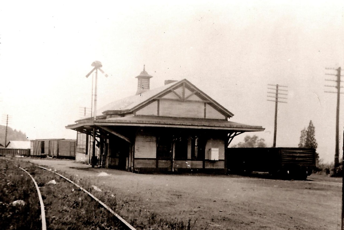
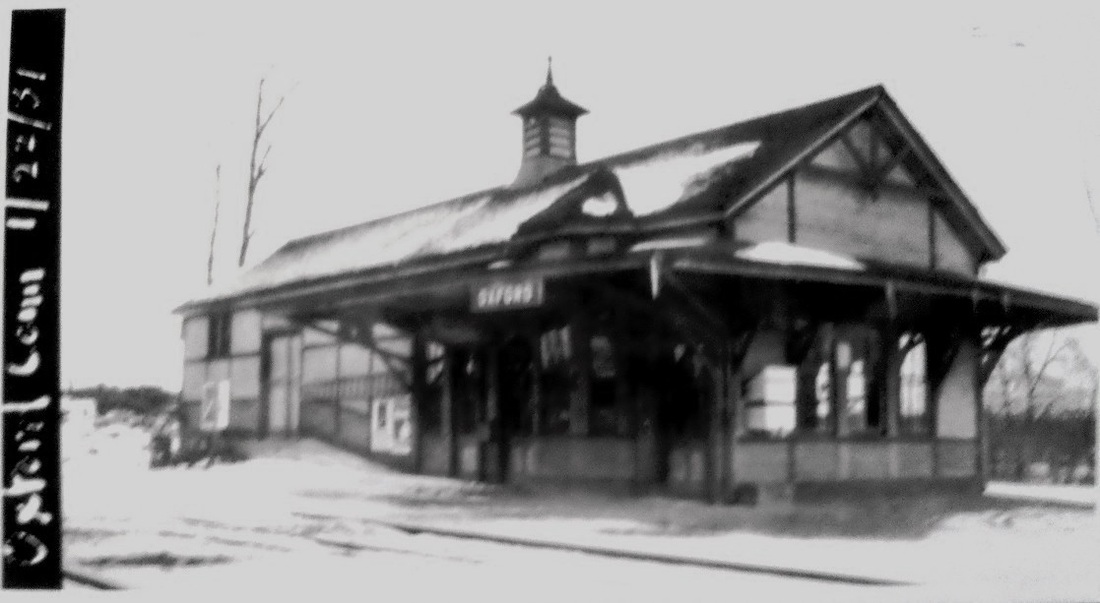
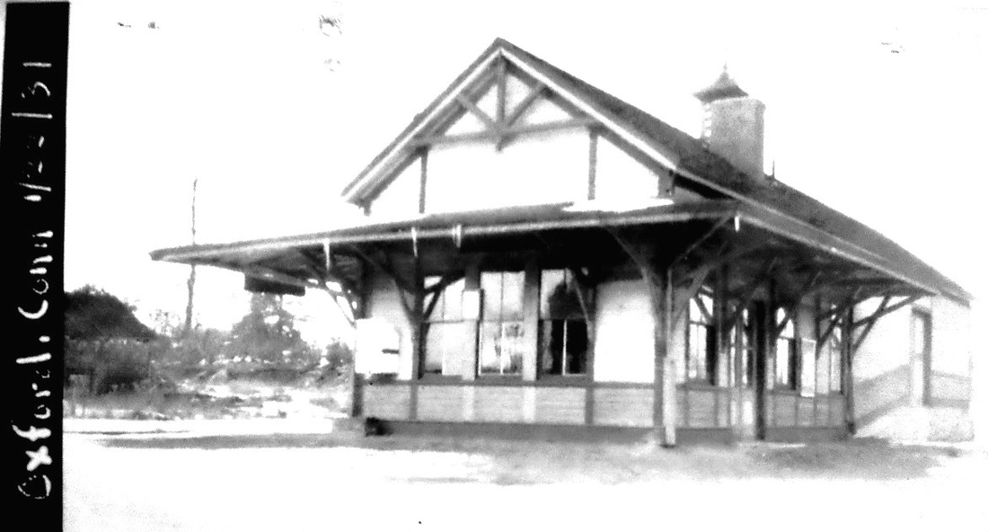
SOUTHFORD [NY&NE, 1881]
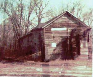
This station in the town of Southbury was said in the Danbury News to be "a fair example of the large stations on the NY&NE westward extension," with "seperate (sic) waiting rooms for the sexes, with toilet conveniences, and telegraph office, and ticket office." Coverage in the Courant goes on to say that the interior finish was oiled wood and the exterior was painted olive green, with red trim and brown roof and that the freight house was in the same building but more plainly finished. Talk about confusion of places names, the post office here was named Eastford (conflicting with another township in the state) and this stop was sometimes called SOUTHBURY to differentiate it from Southbury proper where the stop was originally called POMPERAUG VALLEY or simply POMPERAUG. Did you follow all that? This station would be renamed OXFORD around 1915 per ICC order to put all confusion to rest and avoid operational mishaps. SOUTHFORD, SANDY HOOK, and SOUTHBURY look virtually identical in design. All the extension stations, said to be 12 in number, were contracted to Leman (often misspelled Leaman) Oatman, a well-known Hartford builder. It would appear that he superimposed the freight portion on the rear and over the square passenger section, which by itself might look like the smaller stations of MILL PLAIN, NEWTOWN3, and TOWANTIC. A Courant article, which gives his first name as James, says that he had already finished the Connecticut stations and that he had gotten the contract for the stations from Brewsters to Fishkill. As for the 12 stations, if you count BRADLEY STATION, which is not mentioned on opening day, and FAIR GROUNDS (DANBURY)2, where a station was never built as far as we know, then there were exactly a dozen stops from Waterbury to Mill Plain. The val map shows the arrangement of the railroad facilities here in 1915, including the milk house. The passenger station stood in the southeast quadrant at the grade crossing at today's Rte. 188. The OXFORD station burned to the ground on 6/10/1987, according to an article by Richard Ryan in a newspaper that is not identified on the photocopy we have. The structure was being used for storage at the time. The shot at lower right is one we took in the late 1970s. Shorn of its passenger canopy, the structure still showed the telegraph bay on the track side. [REFS: HDC/08/23/1880/02; NBE/11/17/1880/03: tin roof contract given; HDC/06/21/1881/02; HDC/07/23/1881/02; DN/07/27/1881/01; D137][rev041713, 042122]
This station in the town of Southbury was said in the Danbury News to be "a fair example of the large stations on the NY&NE westward extension," with "seperate (sic) waiting rooms for the sexes, with toilet conveniences, and telegraph office, and ticket office." Coverage in the Courant goes on to say that the interior finish was oiled wood and the exterior was painted olive green, with red trim and brown roof and that the freight house was in the same building but more plainly finished. Talk about confusion of places names, the post office here was named Eastford (conflicting with another township in the state) and this stop was sometimes called SOUTHBURY to differentiate it from Southbury proper where the stop was originally called POMPERAUG VALLEY or simply POMPERAUG. Did you follow all that? This station would be renamed OXFORD around 1915 per ICC order to put all confusion to rest and avoid operational mishaps. SOUTHFORD, SANDY HOOK, and SOUTHBURY look virtually identical in design. All the extension stations, said to be 12 in number, were contracted to Leman (often misspelled Leaman) Oatman, a well-known Hartford builder. It would appear that he superimposed the freight portion on the rear and over the square passenger section, which by itself might look like the smaller stations of MILL PLAIN, NEWTOWN3, and TOWANTIC. A Courant article, which gives his first name as James, says that he had already finished the Connecticut stations and that he had gotten the contract for the stations from Brewsters to Fishkill. As for the 12 stations, if you count BRADLEY STATION, which is not mentioned on opening day, and FAIR GROUNDS (DANBURY)2, where a station was never built as far as we know, then there were exactly a dozen stops from Waterbury to Mill Plain. The val map shows the arrangement of the railroad facilities here in 1915, including the milk house. The passenger station stood in the southeast quadrant at the grade crossing at today's Rte. 188. The OXFORD station burned to the ground on 6/10/1987, according to an article by Richard Ryan in a newspaper that is not identified on the photocopy we have. The structure was being used for storage at the time. The shot at lower right is one we took in the late 1970s. Shorn of its passenger canopy, the structure still showed the telegraph bay on the track side. [REFS: HDC/08/23/1880/02; NBE/11/17/1880/03: tin roof contract given; HDC/06/21/1881/02; HDC/07/23/1881/02; DN/07/27/1881/01; D137][rev041713, 042122]

|
|
|
SOUTHINGTON1 [NH&N, 1849]
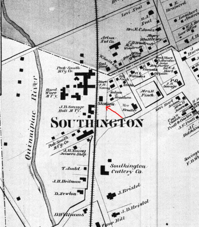
The location is seen to be the same on the 1855HC map at left and on the 1868 Beers map at middle. The image at right is from the Bailey 1878 bird's-eye map and shows the approximate location of the first depot at the red X and the site of the successor station at the red arrow. Inasmuch as Bailey was sketching the town only a few years after the first station was abandoned, it is very likely that it is one of the buildings adjacent to the red X, in the block between High and Centre Sts.
The location is seen to be the same on the 1855HC map at left and on the 1868 Beers map at middle. The image at right is from the Bailey 1878 bird's-eye map and shows the approximate location of the first depot at the red X and the site of the successor station at the red arrow. Inasmuch as Bailey was sketching the town only a few years after the first station was abandoned, it is very likely that it is one of the buildings adjacent to the red X, in the block between High and Centre Sts.
Dave Peters Collection
|

Dave Peters Collection
|
|
Southington Observer
SOUTHINGTON2 [NH&N, 1874]
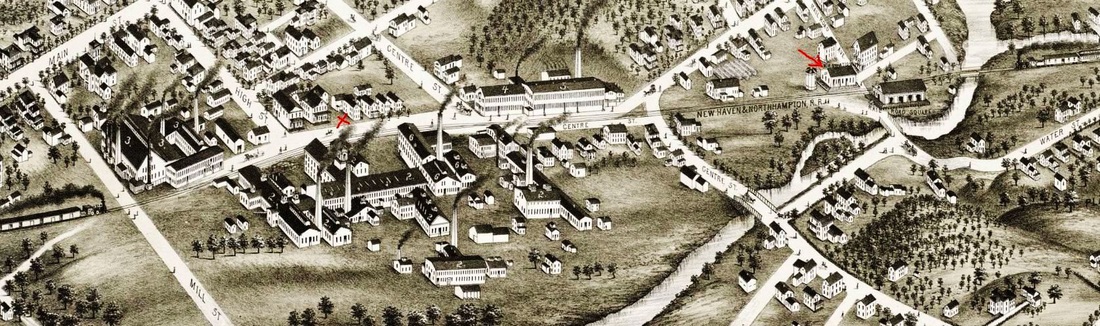
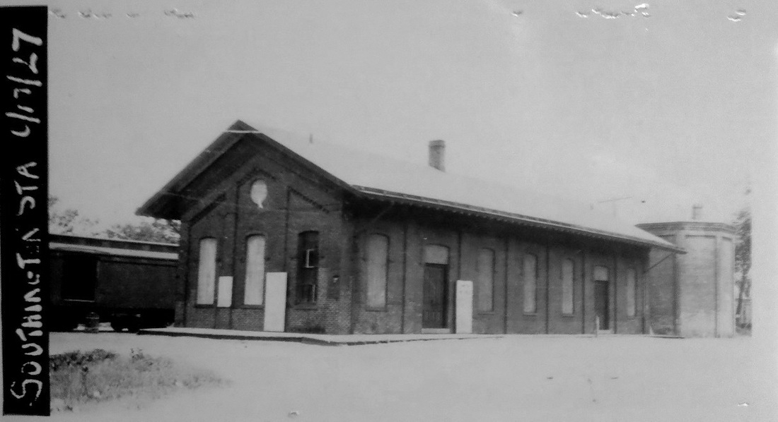
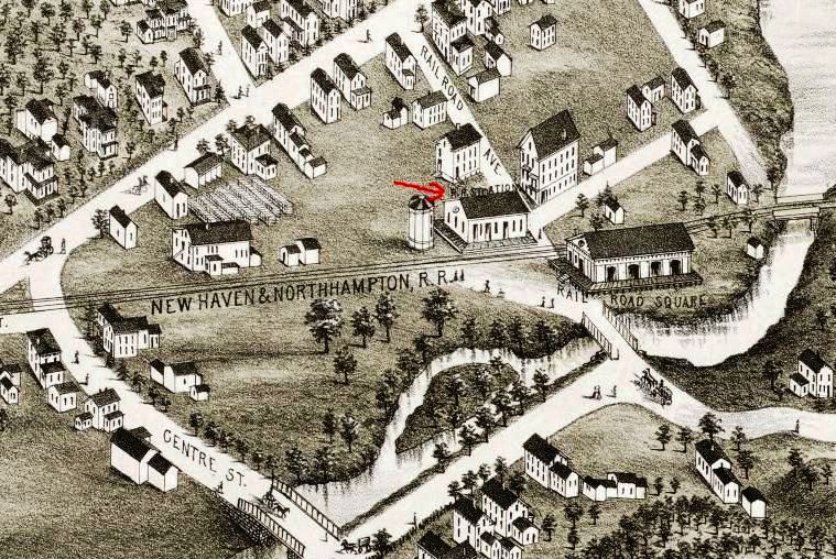
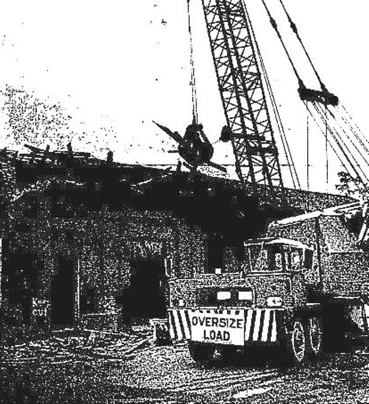
The 1878 Bailey bird's-eye sketch at right shows the second depot. It opened on 5/6/1874, with the Courant reporting that "Today (Wednesday) the passenger trains stop for the first time at the new station in this village. Although many of our people have been opposed to the removal of the station, yet we certainly reap a benefit by going a short distance further to take the train. Superintendent Yeamans has built a station that should command favor, as we now have as fine a depot as any village in the New England of the same population..." The more southerly location to which the article alludes was part of the NH&N's plan to eliminate the PLANTSVILLE stop, a move that would spark a historic and prolonged legal controversy which the railroad would ultimately lose. As early as the 1930s SOUTHINGTON2 was rented and the 1938 SSRR list says that it was sold to G. Mattala(?) presumably in 1938. Forty years later, its deteriorated condition led to newspaper editorials calling for removal of the "visual pollution" at the corner of Railroad Ave. and Germania St. Conrail acquiesced, spurred by the involvement of U.S. Rep. Toby Moffett who called into question the mission of the federally created railroad which was abandoning trackage instead of promoting rail service. The station met the wrecker's ball in its 104th year on 10/12/1977. Even then, salvage dealers were eyeing "the goodly amount of first-grade brick" used in the 1874 construction. [REFS: HDC/05/06/1874/04; CRC22.1875.34; SOB/06/09/1977/01,04,05; SO/10/13/1977/01][rev010518]
The 1878 Bailey bird's-eye sketch at right shows the second depot. It opened on 5/6/1874, with the Courant reporting that "Today (Wednesday) the passenger trains stop for the first time at the new station in this village. Although many of our people have been opposed to the removal of the station, yet we certainly reap a benefit by going a short distance further to take the train. Superintendent Yeamans has built a station that should command favor, as we now have as fine a depot as any village in the New England of the same population..." The more southerly location to which the article alludes was part of the NH&N's plan to eliminate the PLANTSVILLE stop, a move that would spark a historic and prolonged legal controversy which the railroad would ultimately lose. As early as the 1930s SOUTHINGTON2 was rented and the 1938 SSRR list says that it was sold to G. Mattala(?) presumably in 1938. Forty years later, its deteriorated condition led to newspaper editorials calling for removal of the "visual pollution" at the corner of Railroad Ave. and Germania St. Conrail acquiesced, spurred by the involvement of U.S. Rep. Toby Moffett who called into question the mission of the federally created railroad which was abandoning trackage instead of promoting rail service. The station met the wrecker's ball in its 104th year on 10/12/1977. Even then, salvage dealers were eyeing "the goodly amount of first-grade brick" used in the 1874 construction. [REFS: HDC/05/06/1874/04; CRC22.1875.34; SOB/06/09/1977/01,04,05; SO/10/13/1977/01][rev010518]
SOUTHINGTON CORNERS [> PLANTSVILLE]
|
|
|

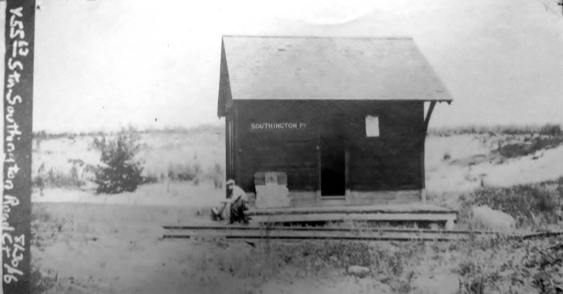
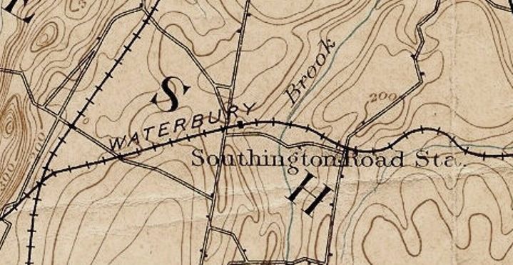
SOUTHINGTON ROAD [M&W, 1892]
The val photo [1] is dated 8/30/1916, less than a year before passenger service would cease. The 1893 topo map [2] shows that the station sat just east of Rte. 10. and north of the track that ran above Creamery Rd. in the town of Cheshire. This stop is not on the opening day timetable in Snow but the excursion poster [4] proves that it was in existence at least by July, 1892. The timing may have had something to do with lease of the MW&CR by the NY&NE late in that year. The val map [3] dates to 1915 and shows the arrangement at that time, with a separate platform across the access road that ran west of the station structure. Click here for the full val map. The heavy dashed line is the Milldale trolley that once ran up Rte. 10. [REFS: S14,21,29][rev010914]
The val photo [1] is dated 8/30/1916, less than a year before passenger service would cease. The 1893 topo map [2] shows that the station sat just east of Rte. 10. and north of the track that ran above Creamery Rd. in the town of Cheshire. This stop is not on the opening day timetable in Snow but the excursion poster [4] proves that it was in existence at least by July, 1892. The timing may have had something to do with lease of the MW&CR by the NY&NE late in that year. The val map [3] dates to 1915 and shows the arrangement at that time, with a separate platform across the access road that ran west of the station structure. Click here for the full val map. The heavy dashed line is the Milldale trolley that once ran up Rte. 10. [REFS: S14,21,29][rev010914]

|
|
|
|
|
|
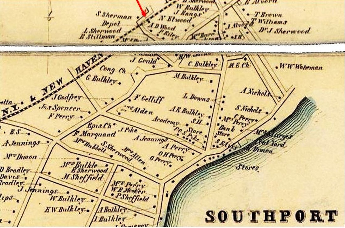
SOUTHPORT1 [NY&NH, 1848]
This stop in the town of Fairfield was an original one on the NY&NH, as shown by the 2/9/1849 schedule at [7]. The board-and-batten, cross-gabled Gothic structure was the standard NY&NH style, as corroborated by comments in an 1850 Boston-New York tour which said that the stations were "nearly all of one style and built almost exactly alike." The woodcut at [1] is from that publication. The location, south of the track, is seen on the 1856FC map at [2] and on the 1867 map at [5]. The station here lasted until 5/17/1884 when sparks from a passing locomotive set it afire. It was valued at $3,000 to $8,000 depending on which newspaper you read; the former seems more accurate. The Register reported the following: "Now that the old depot at Southport, on the Consolidated road, has been burned, a handsome brick structure like that at Fairfield will be erected at once. Vice President Reed is said to have remarked while the fire was in progress: 'We don't care much for the old structure. Should have moved it away this summer, and were contriving for a place on which to put it.'" In fact, there was a newspaper report in February, 1883 that contracts had been let for building a new brick depot here "during the coming season." Perhaps that explains Reed's comments and lackadaisical attitude. The old depot was probably to be repurposed as the freight house before it burned and settled its own fate. [REFS: Bradbury & Guild's Rail-Road Charts, No. II, Boston to New York, p.72; TVH/02/15/1883/02; SR/05/18/1884/01; HDC/05/19/1884/04][rev030515]
This stop in the town of Fairfield was an original one on the NY&NH, as shown by the 2/9/1849 schedule at [7]. The board-and-batten, cross-gabled Gothic structure was the standard NY&NH style, as corroborated by comments in an 1850 Boston-New York tour which said that the stations were "nearly all of one style and built almost exactly alike." The woodcut at [1] is from that publication. The location, south of the track, is seen on the 1856FC map at [2] and on the 1867 map at [5]. The station here lasted until 5/17/1884 when sparks from a passing locomotive set it afire. It was valued at $3,000 to $8,000 depending on which newspaper you read; the former seems more accurate. The Register reported the following: "Now that the old depot at Southport, on the Consolidated road, has been burned, a handsome brick structure like that at Fairfield will be erected at once. Vice President Reed is said to have remarked while the fire was in progress: 'We don't care much for the old structure. Should have moved it away this summer, and were contriving for a place on which to put it.'" In fact, there was a newspaper report in February, 1883 that contracts had been let for building a new brick depot here "during the coming season." Perhaps that explains Reed's comments and lackadaisical attitude. The old depot was probably to be repurposed as the freight house before it burned and settled its own fate. [REFS: Bradbury & Guild's Rail-Road Charts, No. II, Boston to New York, p.72; TVH/02/15/1883/02; SR/05/18/1884/01; HDC/05/19/1884/04][rev030515]
|
|

|
 Robert Gambling
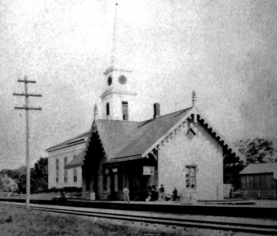
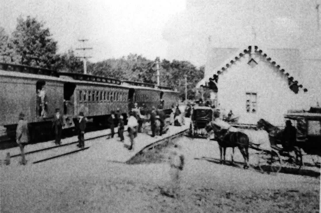
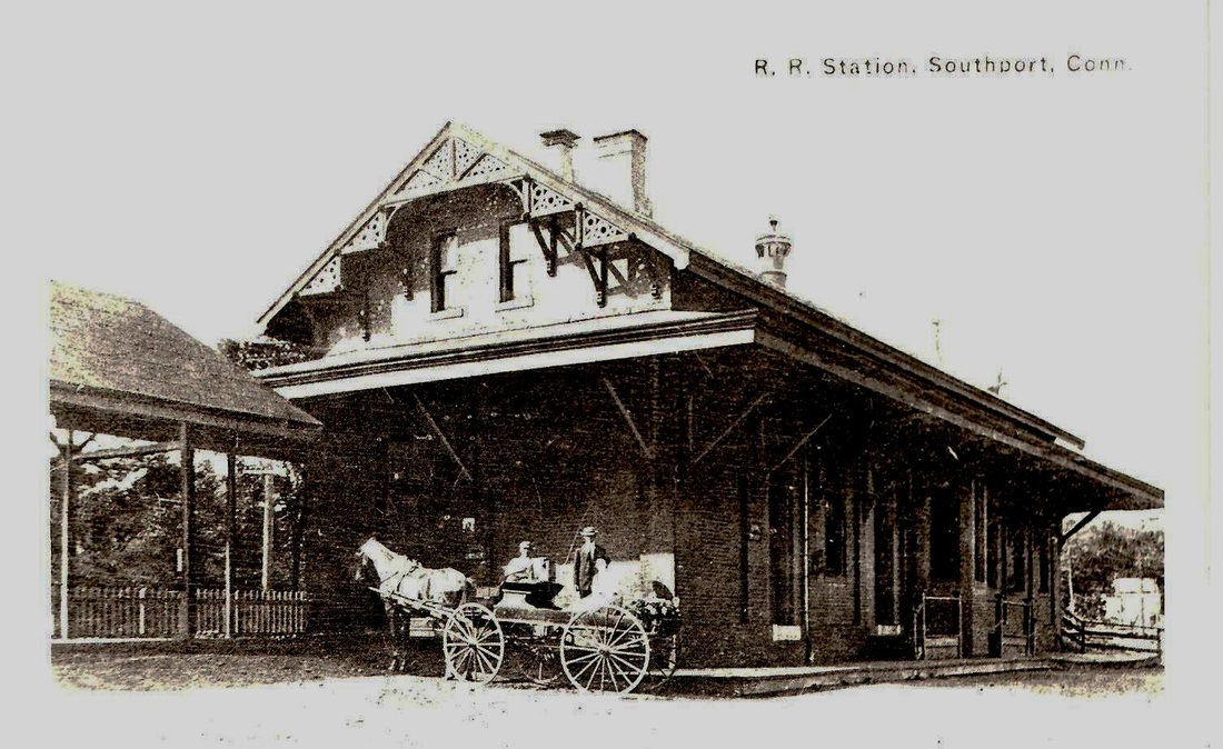
SOUTHPORT2 [NYNH&H, 1884, EB]
The new brick station cost $8,500 and opened on 8/4/1884. The Register said that "it is a model station and said to be the handsomest on the line of the Consolidated road. The waiting rooms are undivided and provided with ample seats, while baggage and telegraph services are made specially convenient." Still standing in 2015, it received an NRHP designation in 1989. The card at [1] is ca. 1900. The val photo at [2] is dated 10/22/1916 and the Penn Central era photo at [3] says 1982. Bob Gambling's shot at [4] was taken in the 1970s. [REFS: HDC/08/02/1884/04; NHER/12/27/1884/04; CRC32.1885.9; NHAR13.1885.8; R92][rev030515]
The new brick station cost $8,500 and opened on 8/4/1884. The Register said that "it is a model station and said to be the handsomest on the line of the Consolidated road. The waiting rooms are undivided and provided with ample seats, while baggage and telegraph services are made specially convenient." Still standing in 2015, it received an NRHP designation in 1989. The card at [1] is ca. 1900. The val photo at [2] is dated 10/22/1916 and the Penn Central era photo at [3] says 1982. Bob Gambling's shot at [4] was taken in the 1970s. [REFS: HDC/08/02/1884/04; NHER/12/27/1884/04; CRC32.1885.9; NHAR13.1885.8; R92][rev030515]

|

|

|
 Caboose_rodeo via Flickr
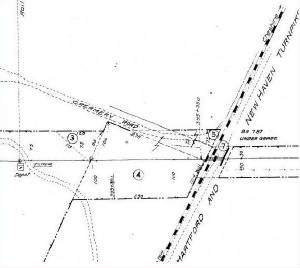
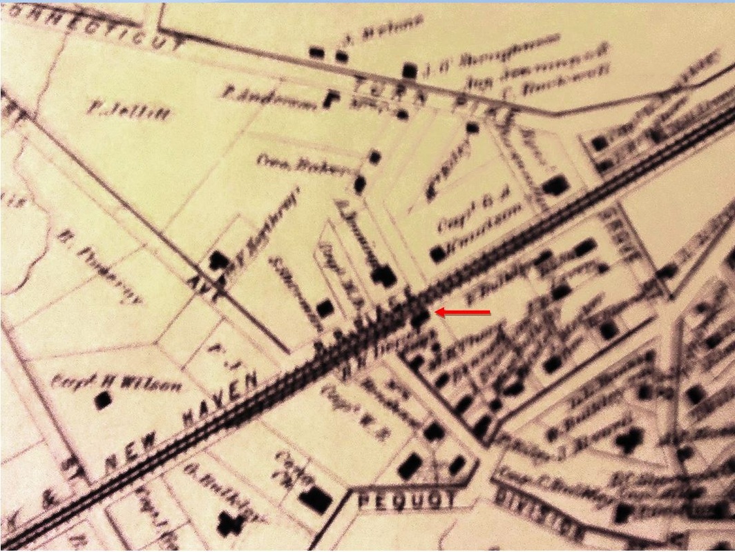
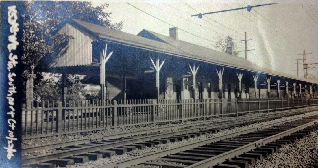
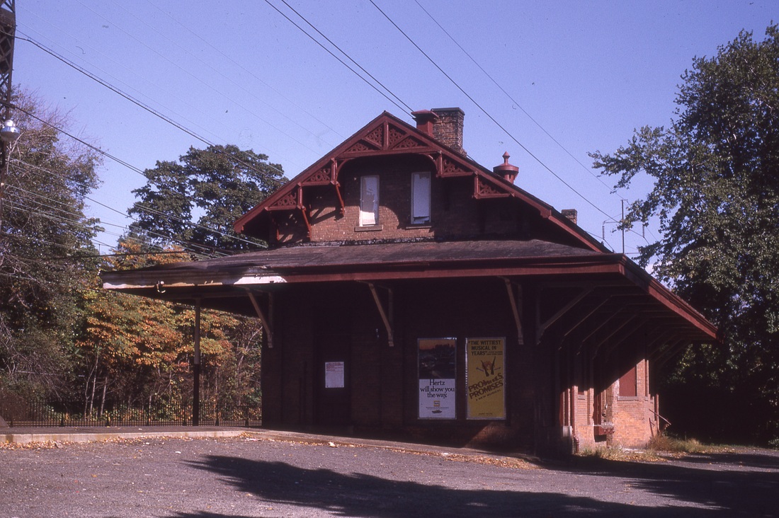
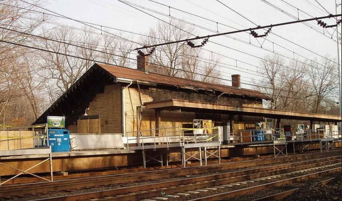
SOUTHPORT3 [NYNH&H, 1891, WB]
Property for this station on the westbound side of the tracks was purchased in 1890. Interestingly, as our U.K. colleague Jim Fergusson [click here] pointed out recently, there is an unusually large distance, 800 feet, between the eastbound and westbound stations, and the freight house is yet again as far in the opposite direction. All we can surmise is the lack of available property to accommodate a closer arrangement. SOUTHPORT3 was completed as part of the four-tracking project that opened from East Norwalk to "the Fairfield quarries" on 2/21/1892. Though John Roy gives it a date range from 1875 to 1899, we think 1891 is a safe bet. The station received an NRHP designation in 1989 as well. Damaged by fire on 1/4/2008 as seen at [4], it has been refurbished and still stands as one of the remaining saltbox-style stations on the New Haven line. The 1915 val map at [3] shows this [FP=frame (wooden) passenger] station at the red arrow, SOUTHPORT2 [BP=Brick Passenger] at the blue arrow and the [FF=frame (wooden)] freight house at the green arrow. [REFS: R93][rev030515]
Property for this station on the westbound side of the tracks was purchased in 1890. Interestingly, as our U.K. colleague Jim Fergusson [click here] pointed out recently, there is an unusually large distance, 800 feet, between the eastbound and westbound stations, and the freight house is yet again as far in the opposite direction. All we can surmise is the lack of available property to accommodate a closer arrangement. SOUTHPORT3 was completed as part of the four-tracking project that opened from East Norwalk to "the Fairfield quarries" on 2/21/1892. Though John Roy gives it a date range from 1875 to 1899, we think 1891 is a safe bet. The station received an NRHP designation in 1989 as well. Damaged by fire on 1/4/2008 as seen at [4], it has been refurbished and still stands as one of the remaining saltbox-style stations on the New Haven line. The 1915 val map at [3] shows this [FP=frame (wooden) passenger] station at the red arrow, SOUTHPORT2 [BP=Brick Passenger] at the blue arrow and the [FF=frame (wooden)] freight house at the green arrow. [REFS: R93][rev030515]