Track 12: CT Passenger Stations, C-CH
See TCS Home Page links for notes, abbreviations, and sources.
Use Track 11 map link to locate stations, rail and trolley lines, and POIs.
CAMP STATION/CANAAN [> PINE GROVE]
Use Track 11 map link to locate stations, rail and trolley lines, and POIs.
CAMP STATION/CANAAN [> PINE GROVE]
|
|
Plainville Historical Society
|
CAMP STATION/PLAINVILLE [HP&F, 1868]
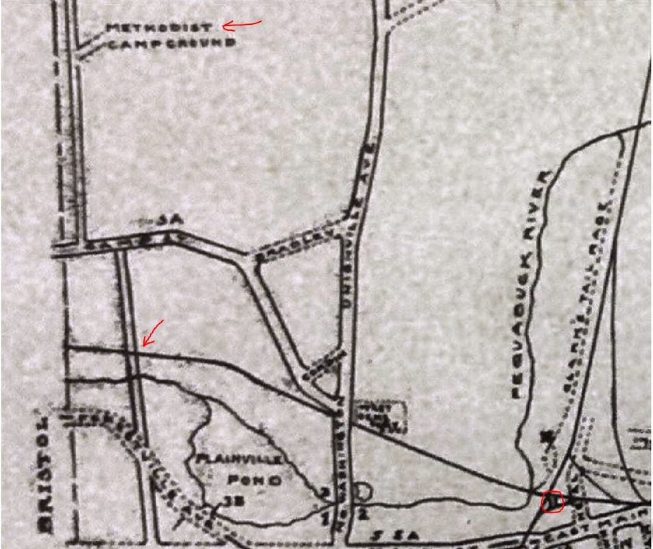
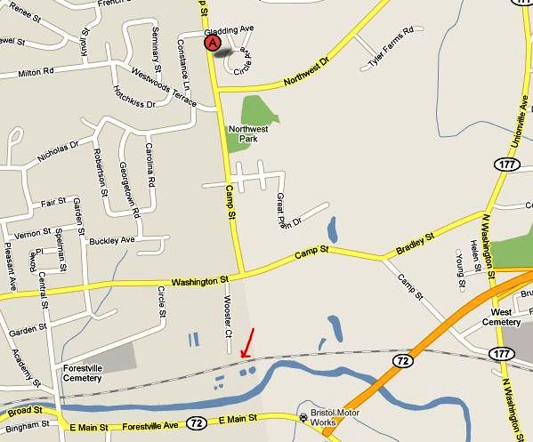
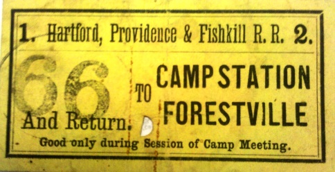
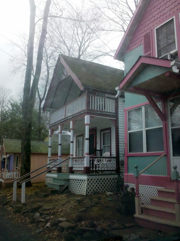
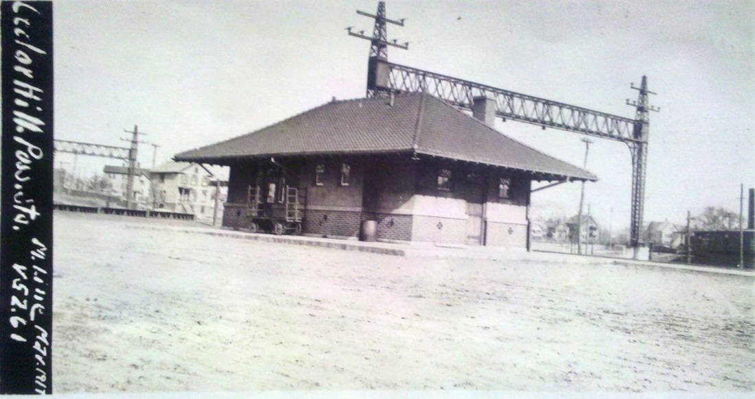
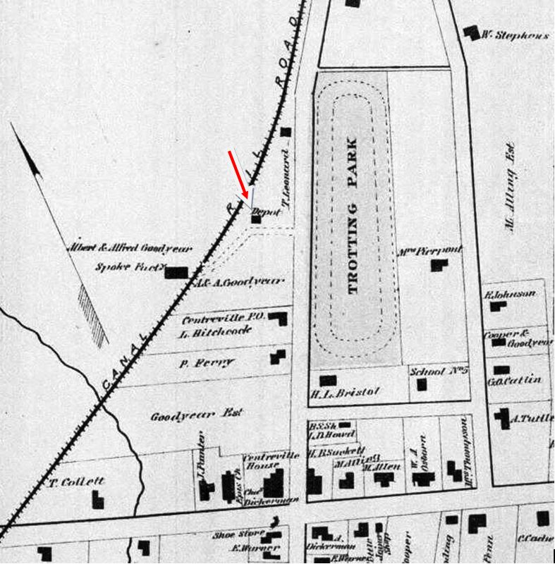
Located about a mile west of the PLAINVILLE station, this was a special stop for the Methodist revival meetings that were held at a church campground. This annual event began in the 1860s and was attended by thousands well into the 1900s. Later incorporated as the New Haven District Camp-Ground Association, the group bought about two acres of land in 1867 about a half mile north of the railroad along what would become known as Camp St. The stop was located at what is now the foot of Wooster St. from which carriages brought many attendees up to the events. The first mention of a stop here comes in an 1868 Connecticut Courant article which says that "... Among the other improvements that the public will appreciate is a new camp station, which will materially lessen the distance from the [Plainville] depot to the grounds..." Still in the news five years later, a structure apparently did not come until 1873 when a Hartford Weekly Times article tells us that "a new station has been made by the Hartford Providence & Fishkill, R.R. company [sic] and this year the company have erected a convenient shelter from the sun or showers, while people are waiting for the trains." An 1875 article said that "all trains will stop at camp station" on the HP&F and that, through "the liberality of the managers," half-price fares were being charged. The 1918 map [1] shows CAMP STATION at the lower red arrow, with the PLAINVILLE station circled to the right. Map [2] pinpoints the camp location today at the 'A' and with the station stop below. The ticket [3] was found in the collection of the Plainville Historical Society [click here], with the kind assistance of the helpful folks there. Today, the colony of cottage structures, once threatened by urban renewal, has an NRHP designation and endures as the Plainville Campground Association, a recent shot seen at [4]. Click here for more. [REFS: HDC/09/02/1863/02; CC/08/15/1868/02; WDA/08/22/1872/02: all trains stop; HDC/07/25/1873/02; CR/08/02/1873/03; MDC/08/15/1873/02; HWT/08/30/1873/02; HDC/08/14/1875 /02; HC/05/27/1895/01; HC/07/23/1900/03; HC/08/10/1919/05][rev012516]
Located about a mile west of the PLAINVILLE station, this was a special stop for the Methodist revival meetings that were held at a church campground. This annual event began in the 1860s and was attended by thousands well into the 1900s. Later incorporated as the New Haven District Camp-Ground Association, the group bought about two acres of land in 1867 about a half mile north of the railroad along what would become known as Camp St. The stop was located at what is now the foot of Wooster St. from which carriages brought many attendees up to the events. The first mention of a stop here comes in an 1868 Connecticut Courant article which says that "... Among the other improvements that the public will appreciate is a new camp station, which will materially lessen the distance from the [Plainville] depot to the grounds..." Still in the news five years later, a structure apparently did not come until 1873 when a Hartford Weekly Times article tells us that "a new station has been made by the Hartford Providence & Fishkill, R.R. company [sic] and this year the company have erected a convenient shelter from the sun or showers, while people are waiting for the trains." An 1875 article said that "all trains will stop at camp station" on the HP&F and that, through "the liberality of the managers," half-price fares were being charged. The 1918 map [1] shows CAMP STATION at the lower red arrow, with the PLAINVILLE station circled to the right. Map [2] pinpoints the camp location today at the 'A' and with the station stop below. The ticket [3] was found in the collection of the Plainville Historical Society [click here], with the kind assistance of the helpful folks there. Today, the colony of cottage structures, once threatened by urban renewal, has an NRHP designation and endures as the Plainville Campground Association, a recent shot seen at [4]. Click here for more. [REFS: HDC/09/02/1863/02; CC/08/15/1868/02; WDA/08/22/1872/02: all trains stop; HDC/07/25/1873/02; CR/08/02/1873/03; MDC/08/15/1873/02; HWT/08/30/1873/02; HDC/08/14/1875 /02; HC/05/27/1895/01; HC/07/23/1900/03; HC/08/10/1919/05][rev012516]

|
|
|
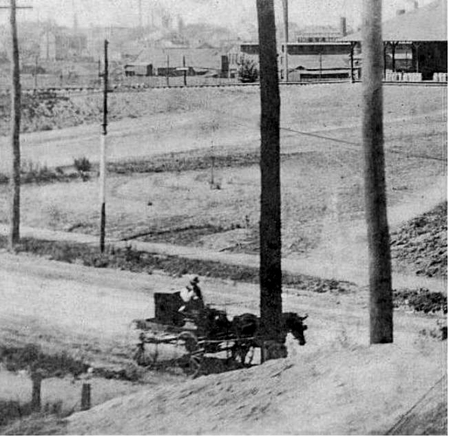
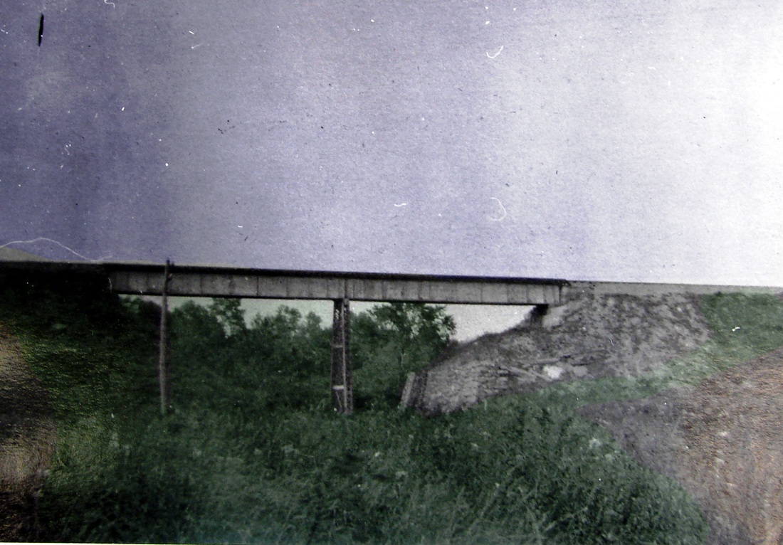
CAMP STATION/WILLIMANTIC [HP&F/NLN, c1860]
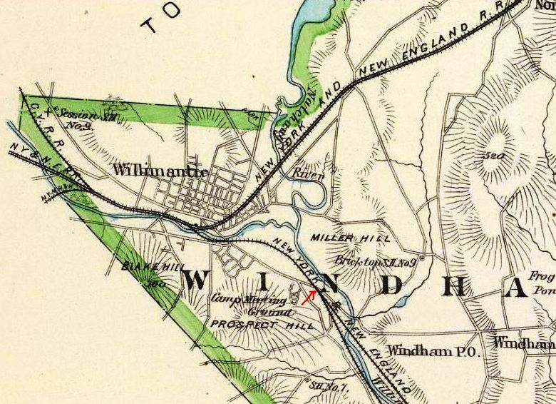
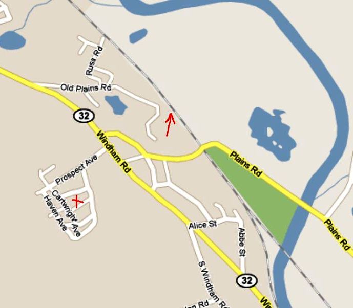
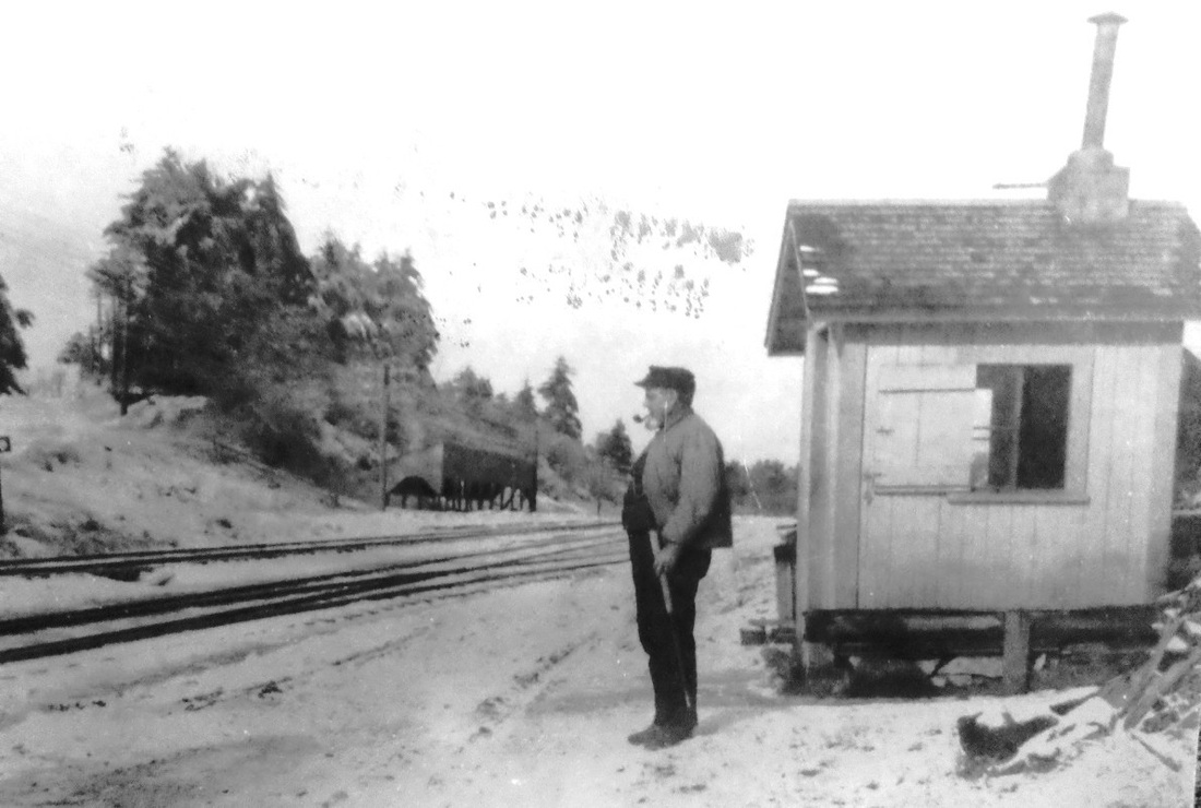
Also known as CAMP or CAMP MEETING STATION, this was a stop about a mile and a half south of Willimantic that was served by both the HP&F and the NLN. The Methodist camp meetings began in 1860 and the grounds here were undoubtedly chosen for the access to two railroads. The HP&F alone brought four thousand people to the August revival week in 1865 and an 1889 article reaffirmed what by then was undoubtedly the customary stopping of all trains on both roads. Since this station appears on no map or timetable, it was likely used just on these annual occasions. Of the depot here, a Courant reporter in 1865 said it was "nothing more than a station, two sheds constructed of rough boards, with a standing place for shelter in case of rain, and a couple of platforms, being all there is of it." Whether that describes the structure we see in the photos, which looks more a covered wood shelter, is unclear. In the upper photo, the track all the way to the left is the NLN and the ones on the right are the HP&F, paralleling each other out of Willimantic to split just south of here, the NLN going to New London and the HP&F to Providence. The campground up the hill is shown on the 1893 map [middle] and at the red X on the current map. The arrows on both maps show where the station was at the old Plains Rd. crossing. By the early 1900s, the religious fervor was waning and Victorian vacation cottages were replacing the tents, a trend decried by a minister quoted in a 1911 Courant article. The 1915 maps were show no station [click here], though the shanty still appears. The gate tender seen here would be out of a job by 1910 when, after a decade of delay, a single bridge would finally eliminate the dangers of two adjacent, multi-track grade crossings. We think that both photos date just prior to the completion of that project. [REFS: HDC/08/11/1860/02; HDC/08/29/1863/02; HDC/08/30/1865/02; HDC/09/04/1865/02; HDC/09/07/1865/02; HDC/09/07/1869/02; HC/08/12/1889/06; HC/04/28/1911 /15; HC/08/24/1911/11][rev011516]
Also known as CAMP or CAMP MEETING STATION, this was a stop about a mile and a half south of Willimantic that was served by both the HP&F and the NLN. The Methodist camp meetings began in 1860 and the grounds here were undoubtedly chosen for the access to two railroads. The HP&F alone brought four thousand people to the August revival week in 1865 and an 1889 article reaffirmed what by then was undoubtedly the customary stopping of all trains on both roads. Since this station appears on no map or timetable, it was likely used just on these annual occasions. Of the depot here, a Courant reporter in 1865 said it was "nothing more than a station, two sheds constructed of rough boards, with a standing place for shelter in case of rain, and a couple of platforms, being all there is of it." Whether that describes the structure we see in the photos, which looks more a covered wood shelter, is unclear. In the upper photo, the track all the way to the left is the NLN and the ones on the right are the HP&F, paralleling each other out of Willimantic to split just south of here, the NLN going to New London and the HP&F to Providence. The campground up the hill is shown on the 1893 map [middle] and at the red X on the current map. The arrows on both maps show where the station was at the old Plains Rd. crossing. By the early 1900s, the religious fervor was waning and Victorian vacation cottages were replacing the tents, a trend decried by a minister quoted in a 1911 Courant article. The 1915 maps were show no station [click here], though the shanty still appears. The gate tender seen here would be out of a job by 1910 when, after a decade of delay, a single bridge would finally eliminate the dangers of two adjacent, multi-track grade crossings. We think that both photos date just prior to the completion of that project. [REFS: HDC/08/11/1860/02; HDC/08/29/1863/02; HDC/08/30/1865/02; HDC/09/04/1865/02; HDC/09/07/1865/02; HDC/09/07/1869/02; HC/08/12/1889/06; HC/04/28/1911 /15; HC/08/24/1911/11][rev011516]
CAMPBELL [NYNH&H, c1900?]
This was a stop on the Rockville RR, 1.96 miles from VERNON, when electric service was operated in the early 1900s.
This was a stop on the Rockville RR, 1.96 miles from VERNON, when electric service was operated in the early 1900s.
|
|
|
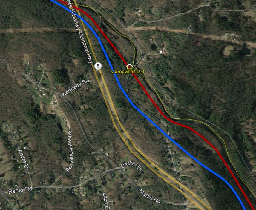
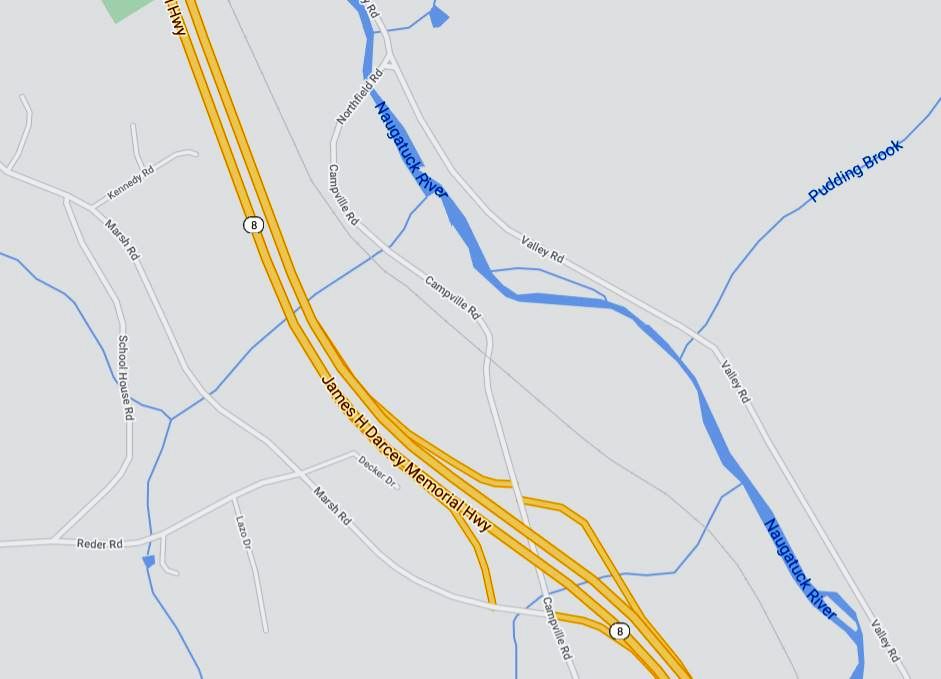
CAMPVILLE1 [NRR, 1849]
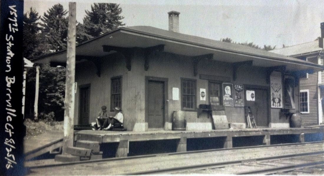
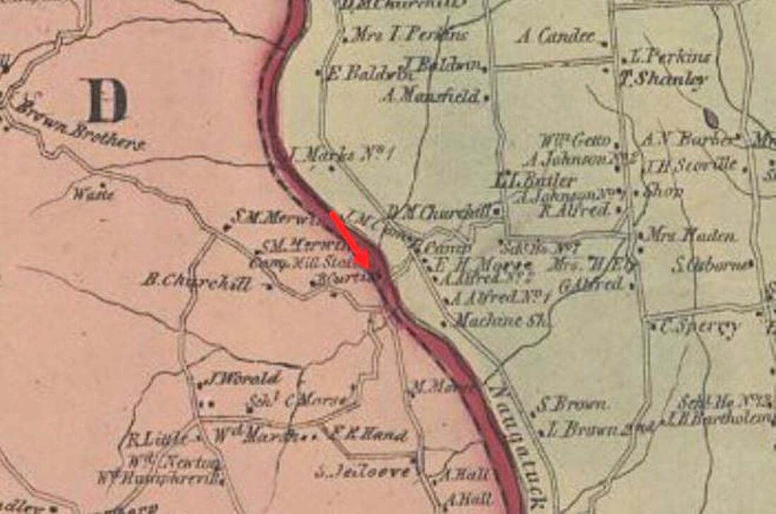
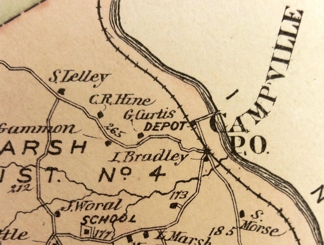
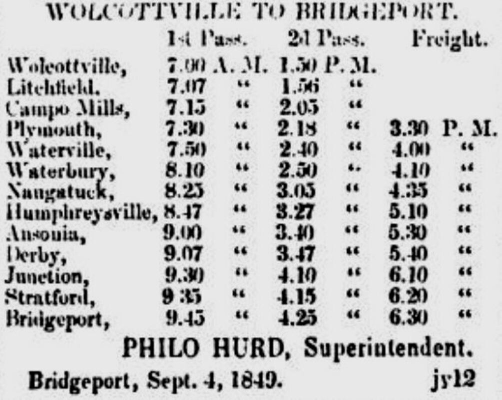
This village in the far northeasternmost part of the town of Litchfield was first called CAMPS MILLS and it was an original stop when the first NRR train came through on 9/5/1849. The Derby Journal snippet at [4] is the earliest newspaper timetable we could find, showing the stop with a typo as Campo Mills, between PLYMOUTH (later THOMASTON) and LITCHFIELD (later EAST LITCHFIELD). The village was named for Jabez Camp who purchased land here in 1840 and operated several mills over the years. The result was a community of 100 homes, two inns, a clock factory plus smaller businesses, extending across the Naugatuck River and into the town of Harwinton with which it shared its identity. The trans-river sprawl is already apparent on the 1854LC map at [2] where our red arrow points to the depot. As early as 1856, the CAMPVILLE name is seen, as it is on the 1874 Beers map of Litchfield County at [3]. We have no idea of the traffic generated here but 500 barrels of cider was shipped from this station for the 1862 season and there was kvetching about service in 1875 when the milk train would not stop for the Red Cap eleven who had to walk to EAST LITCHFIELD to catch the passenger train for their game with the Nameless club at Winsted. The Red Caps won 10-7 but the WINSTED agent would not sell them return tickets on the milk train to CAMPVILLE so they had to pay the conductor the extra five cents each on board the train. In commenting on this poor service to their station, the disappointed locals said that CAMPVILLE has a depot "... which is a marble palace in comparison with the shed at REYNOLDS BRIDGE..." We have no photo of CAMPVILLE1 but it would not be unreasonable to think that it looked like the image at [1] of the BURRVILLE depot which was an archetype of the early NRR stations. Ironically, the "marble palace" words would come home to roost because the aforementioned REYNOLDS BRIDGE "shed" would be moved to become CAMPVILLE3 in 1925 after CAMPVILLE2 burned! See both entries below. Whatever the first depot looked like, there had been complaints about its condition for years and in their May, 1893 inspection the state railroad commissioners said that the "... depot building at Campville station on the Naugatuck division has for some time been very much out of repair and is now no longer safe for the patrons of the road. The floor timbers are most of them unsound or broken and the the former platform either entirely gone or in unsound condition. It should either be repaired at once or replaced by a suitable building." Likely 40 years old at that point, CAMPVILLE1 conveniently gave up the ghost in a fire a month later on 7/4/1893. While the Waterbury Evening Democrat reported that the "... railroad company was about to build a new structure... [and now with the fire] the work will be begun at once," the commissioners said in their December-issued 1893 annual report that it had not yet been built. Interesting date for a depot to burn? Ones at TYLER CITY and other places burned over the years on the day the nation's independence is celebrated, sometimes as part of the exuberant festivities. [REFS: DJ/09/20/1849/03; LRE/01/24/1850/04; LRE/02/08/1856/01; SAD/12/26/1862/02; HDC/06/22/1871/04; WDA/10/22/1875/04; PL1883; NHER/02/14/1891/04; NHER/08/07/1891/04; WES/06/10 /1893/04; WED/07/05/1893/04; CRC41.1893.89; WRA/10/22/2012/00][rev121614, 121618, 112420, 121520]
This village in the far northeasternmost part of the town of Litchfield was first called CAMPS MILLS and it was an original stop when the first NRR train came through on 9/5/1849. The Derby Journal snippet at [4] is the earliest newspaper timetable we could find, showing the stop with a typo as Campo Mills, between PLYMOUTH (later THOMASTON) and LITCHFIELD (later EAST LITCHFIELD). The village was named for Jabez Camp who purchased land here in 1840 and operated several mills over the years. The result was a community of 100 homes, two inns, a clock factory plus smaller businesses, extending across the Naugatuck River and into the town of Harwinton with which it shared its identity. The trans-river sprawl is already apparent on the 1854LC map at [2] where our red arrow points to the depot. As early as 1856, the CAMPVILLE name is seen, as it is on the 1874 Beers map of Litchfield County at [3]. We have no idea of the traffic generated here but 500 barrels of cider was shipped from this station for the 1862 season and there was kvetching about service in 1875 when the milk train would not stop for the Red Cap eleven who had to walk to EAST LITCHFIELD to catch the passenger train for their game with the Nameless club at Winsted. The Red Caps won 10-7 but the WINSTED agent would not sell them return tickets on the milk train to CAMPVILLE so they had to pay the conductor the extra five cents each on board the train. In commenting on this poor service to their station, the disappointed locals said that CAMPVILLE has a depot "... which is a marble palace in comparison with the shed at REYNOLDS BRIDGE..." We have no photo of CAMPVILLE1 but it would not be unreasonable to think that it looked like the image at [1] of the BURRVILLE depot which was an archetype of the early NRR stations. Ironically, the "marble palace" words would come home to roost because the aforementioned REYNOLDS BRIDGE "shed" would be moved to become CAMPVILLE3 in 1925 after CAMPVILLE2 burned! See both entries below. Whatever the first depot looked like, there had been complaints about its condition for years and in their May, 1893 inspection the state railroad commissioners said that the "... depot building at Campville station on the Naugatuck division has for some time been very much out of repair and is now no longer safe for the patrons of the road. The floor timbers are most of them unsound or broken and the the former platform either entirely gone or in unsound condition. It should either be repaired at once or replaced by a suitable building." Likely 40 years old at that point, CAMPVILLE1 conveniently gave up the ghost in a fire a month later on 7/4/1893. While the Waterbury Evening Democrat reported that the "... railroad company was about to build a new structure... [and now with the fire] the work will be begun at once," the commissioners said in their December-issued 1893 annual report that it had not yet been built. Interesting date for a depot to burn? Ones at TYLER CITY and other places burned over the years on the day the nation's independence is celebrated, sometimes as part of the exuberant festivities. [REFS: DJ/09/20/1849/03; LRE/01/24/1850/04; LRE/02/08/1856/01; SAD/12/26/1862/02; HDC/06/22/1871/04; WDA/10/22/1875/04; PL1883; NHER/02/14/1891/04; NHER/08/07/1891/04; WES/06/10 /1893/04; WED/07/05/1893/04; CRC41.1893.89; WRA/10/22/2012/00][rev121614, 121618, 112420, 121520]
National Archives
|
Connecticut State Library Archives
|
Conn. State Library Archives
|
New Haven Museum
|
Max Miller Collection
|

TylerCityStation Collection
|
 Connecticut State LIbrary Archives
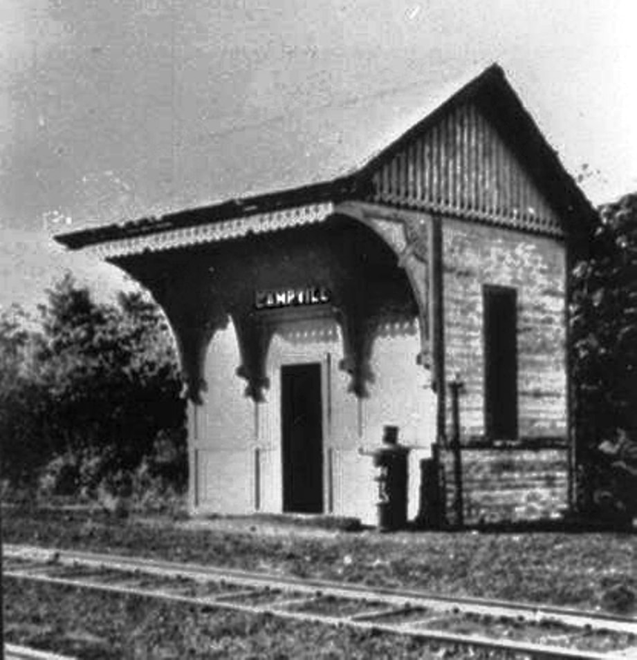
CAMPVILLE2 [NYNH&H, 1894]
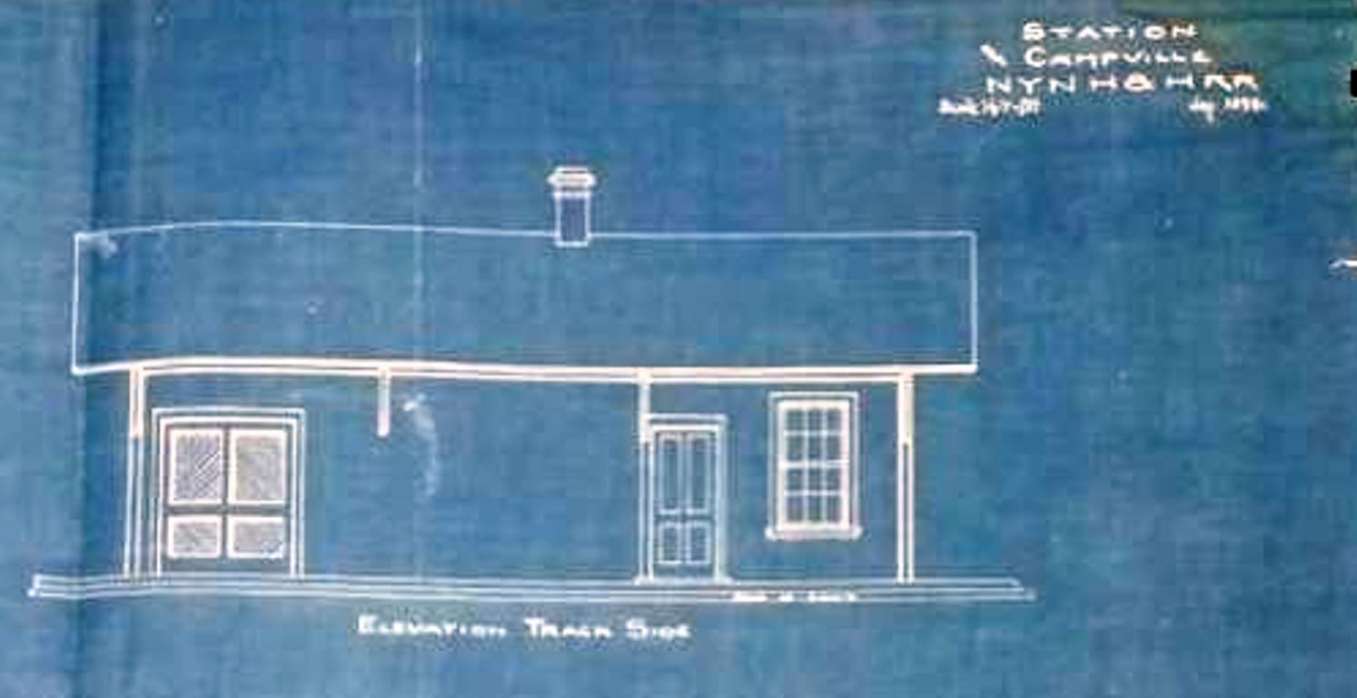
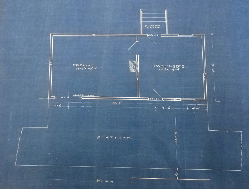
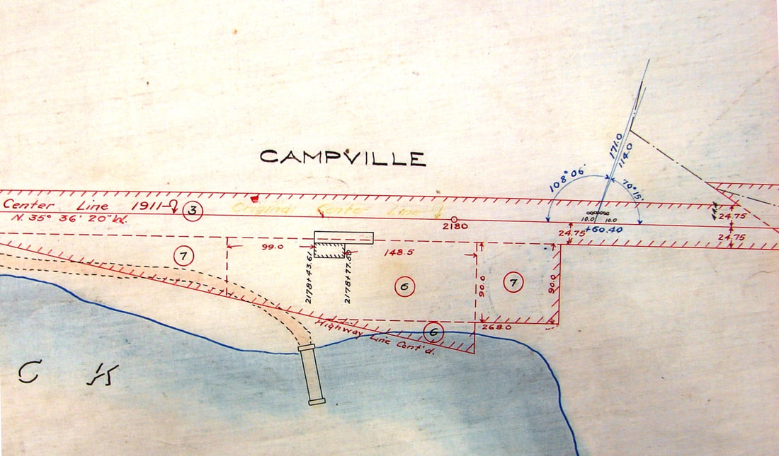
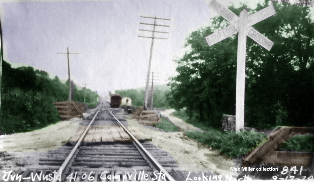
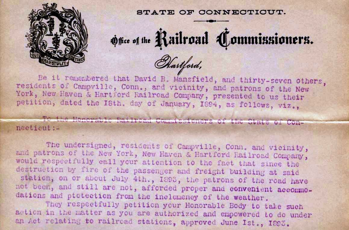
The val photo at [1] likely dates to 8/25/1916 when others along the NRR were taken. A petition on 1/18/1894 from 38 local residents, now with no depot at all, complained of the lack of protection from the elements here. The images seen at [2] and [3] are taken from the architectural plan for the new station and show a date of January, 1894; this original blueprint is cited below as RRM. Could the NYNH&H have responded in haste to the petition, even though the newspaper said when CAMPVILLE1 burned the previous July that plans were in the works then? One could speculate that the railroad took a file plan for a small country depot and stamped it for here. No actual completion or opening date has been found in the newspapers or the railroad or commisioners' records. The 35x15-ft wooden structure sat on the east side of the tracks. The waiting room measured 14x14 feet and the freight room 19.6x14. We wonder if the small rectangle in the middle, which appears to be accessible only to the passenger side, is a rest room. The image at [4] is a ca. 1900 real estate map of the grounds. The 9/17/1924 PUC view at [5] looks north. Al Weaver's colorization makes the details stand out; a box car sits spotted on the house track just below the depot. The shot at [6] looks west at the rear of the station. The Naugatuck River narrowed behind the depot and was bridged here. Perhaps the woman in the lower right is the stationmaster's wife and the dog is the family pet. Interestingly, an 1871 newspaper article relates that the agent lost his dog on a trip to New York. A few days later "... the missing animal was found, looking much exhausted. By a singular instinct it had found its way home -- a distance of 100 miles." Another photograph, which may be the mate to this one, shows a house that is possibly the family residence on a bluff behind the station. The image at [7] is the top portion of the typed version of 1/18/1894 petition. The original handwritten letter is also preserved at CSLIB and cited below as RRL. According to Bob Lord, this station burned in 1925 and was replaced by the REYNOLDS BRIDGE waiting station that became CAMPVILLE3. [REFS: HDC/06/02/1871/04; CRC41.1893.39; NHER/06/10/1893/03; CSLIB RG041.001: RRL 1/18/1894 (Series 2, box 31), RRM 104 (Series 10); D89][rev121520]
The val photo at [1] likely dates to 8/25/1916 when others along the NRR were taken. A petition on 1/18/1894 from 38 local residents, now with no depot at all, complained of the lack of protection from the elements here. The images seen at [2] and [3] are taken from the architectural plan for the new station and show a date of January, 1894; this original blueprint is cited below as RRM. Could the NYNH&H have responded in haste to the petition, even though the newspaper said when CAMPVILLE1 burned the previous July that plans were in the works then? One could speculate that the railroad took a file plan for a small country depot and stamped it for here. No actual completion or opening date has been found in the newspapers or the railroad or commisioners' records. The 35x15-ft wooden structure sat on the east side of the tracks. The waiting room measured 14x14 feet and the freight room 19.6x14. We wonder if the small rectangle in the middle, which appears to be accessible only to the passenger side, is a rest room. The image at [4] is a ca. 1900 real estate map of the grounds. The 9/17/1924 PUC view at [5] looks north. Al Weaver's colorization makes the details stand out; a box car sits spotted on the house track just below the depot. The shot at [6] looks west at the rear of the station. The Naugatuck River narrowed behind the depot and was bridged here. Perhaps the woman in the lower right is the stationmaster's wife and the dog is the family pet. Interestingly, an 1871 newspaper article relates that the agent lost his dog on a trip to New York. A few days later "... the missing animal was found, looking much exhausted. By a singular instinct it had found its way home -- a distance of 100 miles." Another photograph, which may be the mate to this one, shows a house that is possibly the family residence on a bluff behind the station. The image at [7] is the top portion of the typed version of 1/18/1894 petition. The original handwritten letter is also preserved at CSLIB and cited below as RRL. According to Bob Lord, this station burned in 1925 and was replaced by the REYNOLDS BRIDGE waiting station that became CAMPVILLE3. [REFS: HDC/06/02/1871/04; CRC41.1893.39; NHER/06/10/1893/03; CSLIB RG041.001: RRL 1/18/1894 (Series 2, box 31), RRM 104 (Series 10); D89][rev121520]
|
|
|
CAMPVILLE3 [NYNH&H, 1925]
This handsomely ornamented structure, likely the one derogatorily referred to as a shed in our first entry, was the former REYNOLDS BRIDGE station. Off-hand the only other location we can think of where there was a match was BALDWINS, just above NAUGATUCK JCT, aka DEVON, also on the NRR. According to materials to be added to the Leroy Roberts Collection at UConn, this 10x15-ft, slate-roofed depot was moved here on 5/8/1925 after CAMPVILLE2 burned. The only answer as to why the railroad would move a station here at this late date would be that there was still some passenger traffic. A year later, however, there would be no more as this and several other stations from Waterbury to Winsted lost service in June, 1926. The structure may have been used for freight storage thereafter but all service ended here with the retirement of this station approved on 8/1/1935 per Authorization for Expenditure (AFE) 29708. The NYNH&H estimated it would cost them $1,036 to demolish the structure and clear the site. Instead the building was sold to Howard Terrell of Woodbury for the sum of $5.00 and the removal was completed on 9/03/1935. Sale of assets was ongoing with the railroad's declaration of bankruptcy that year, which was of course due to the financial hardships of the Great Depression. Today, you would find only a shadow of the former village. Take Exit 41 from Rte 8 and head east to the crossing of the Naugatuck River. You will first cross the current track via an overgrde bridge, relocated after the building of the Thomaston Dam which was dedicated on 6/16/1961. Just before the river, you will cross the old ROW where the Campville stations stood to the north. Trackage from Torrington to Winsted was abandoned in 1963 but the trains of the reborn NRR still haul passengers and freight past the CAMPVILLE site today. [REFS: HC/06/20/1926/A12; HC/06/16/1961/21A][rev121520]
This handsomely ornamented structure, likely the one derogatorily referred to as a shed in our first entry, was the former REYNOLDS BRIDGE station. Off-hand the only other location we can think of where there was a match was BALDWINS, just above NAUGATUCK JCT, aka DEVON, also on the NRR. According to materials to be added to the Leroy Roberts Collection at UConn, this 10x15-ft, slate-roofed depot was moved here on 5/8/1925 after CAMPVILLE2 burned. The only answer as to why the railroad would move a station here at this late date would be that there was still some passenger traffic. A year later, however, there would be no more as this and several other stations from Waterbury to Winsted lost service in June, 1926. The structure may have been used for freight storage thereafter but all service ended here with the retirement of this station approved on 8/1/1935 per Authorization for Expenditure (AFE) 29708. The NYNH&H estimated it would cost them $1,036 to demolish the structure and clear the site. Instead the building was sold to Howard Terrell of Woodbury for the sum of $5.00 and the removal was completed on 9/03/1935. Sale of assets was ongoing with the railroad's declaration of bankruptcy that year, which was of course due to the financial hardships of the Great Depression. Today, you would find only a shadow of the former village. Take Exit 41 from Rte 8 and head east to the crossing of the Naugatuck River. You will first cross the current track via an overgrde bridge, relocated after the building of the Thomaston Dam which was dedicated on 6/16/1961. Just before the river, you will cross the old ROW where the Campville stations stood to the north. Trackage from Torrington to Winsted was abandoned in 1963 but the trains of the reborn NRR still haul passengers and freight past the CAMPVILLE site today. [REFS: HC/06/20/1926/A12; HC/06/16/1961/21A][rev121520]
|
|

|

CANAAN1 [HRR, 1842]
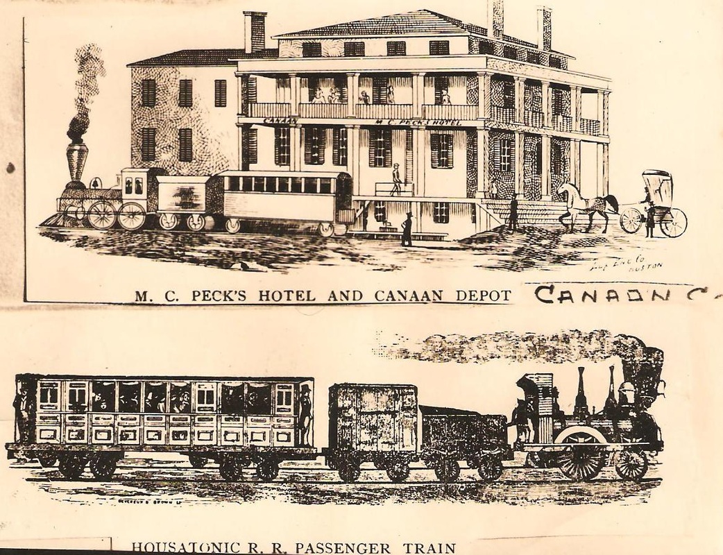
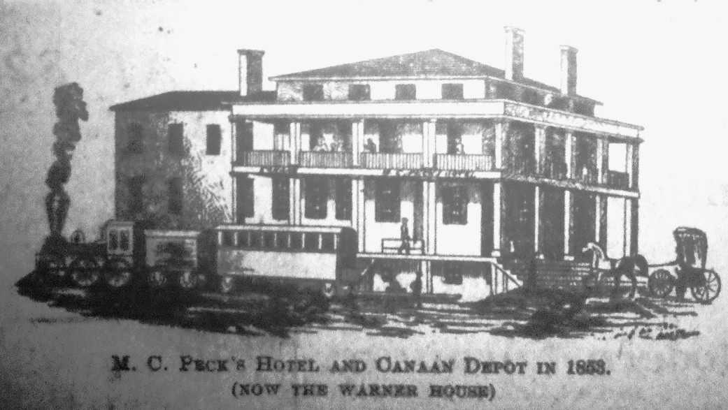
The hotel that housed the first station here in North Canaan was built just before the HRR opened in 1842. The owner, Colonel Barstow, christened it 'Our House' and a later owner, Major C. Peck, renamed it Peck's Hotel in 1853. The image at upper left reproduces the newspaper photo [middle] that we found in a 1906 Connecticut Western News article and contains the important date clarification of 1853. The accompanying text gives a brief history of the building, which went on later to become the Warner House and says that "the east parlor was used as the waiting room and ticket office until a station was built in 1872." We had wondered if the HRR went some thirty years before building a station in this town and apparently the answer is yes! The 1854LC map shows a depot west of the track and a little farther north of Main St. and now we know that this had to be the freight house and not a passenger station. It is interesting to speculate on what would have happened if the CW had not opened their line through this town in 1871. The HRR may have continued to use the hotel, for which it undoubtedly paid a rental, and possibly never built a depot at all. Owing to the fact that the CW opened in December, 1871 and used the hotel along with the HRR until the 1872 structure in our next entry was built, the hotel was Canaan's first 'union station.' It also reportedly housed railroad offices at some point and was the southern terminus for the Berkshire Street Railway, whose car is seen in the image at lower right. The hotel survived until the late 1980s, according to John Roy. [REFS: RF/02/15/1842/03; MC/08/22/1855/02; CWN/09/06/1906/01; R38][rev061013]
The hotel that housed the first station here in North Canaan was built just before the HRR opened in 1842. The owner, Colonel Barstow, christened it 'Our House' and a later owner, Major C. Peck, renamed it Peck's Hotel in 1853. The image at upper left reproduces the newspaper photo [middle] that we found in a 1906 Connecticut Western News article and contains the important date clarification of 1853. The accompanying text gives a brief history of the building, which went on later to become the Warner House and says that "the east parlor was used as the waiting room and ticket office until a station was built in 1872." We had wondered if the HRR went some thirty years before building a station in this town and apparently the answer is yes! The 1854LC map shows a depot west of the track and a little farther north of Main St. and now we know that this had to be the freight house and not a passenger station. It is interesting to speculate on what would have happened if the CW had not opened their line through this town in 1871. The HRR may have continued to use the hotel, for which it undoubtedly paid a rental, and possibly never built a depot at all. Owing to the fact that the CW opened in December, 1871 and used the hotel along with the HRR until the 1872 structure in our next entry was built, the hotel was Canaan's first 'union station.' It also reportedly housed railroad offices at some point and was the southern terminus for the Berkshire Street Railway, whose car is seen in the image at lower right. The hotel survived until the late 1980s, according to John Roy. [REFS: RF/02/15/1842/03; MC/08/22/1855/02; CWN/09/06/1906/01; R38][rev061013]
|

|
|
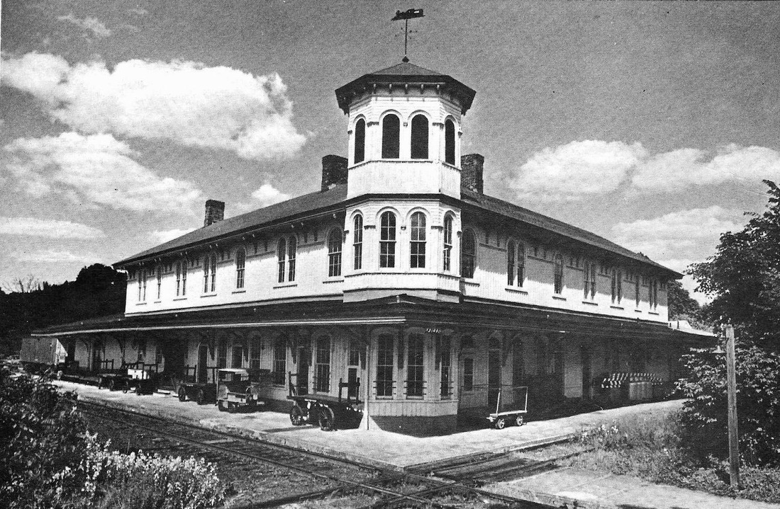
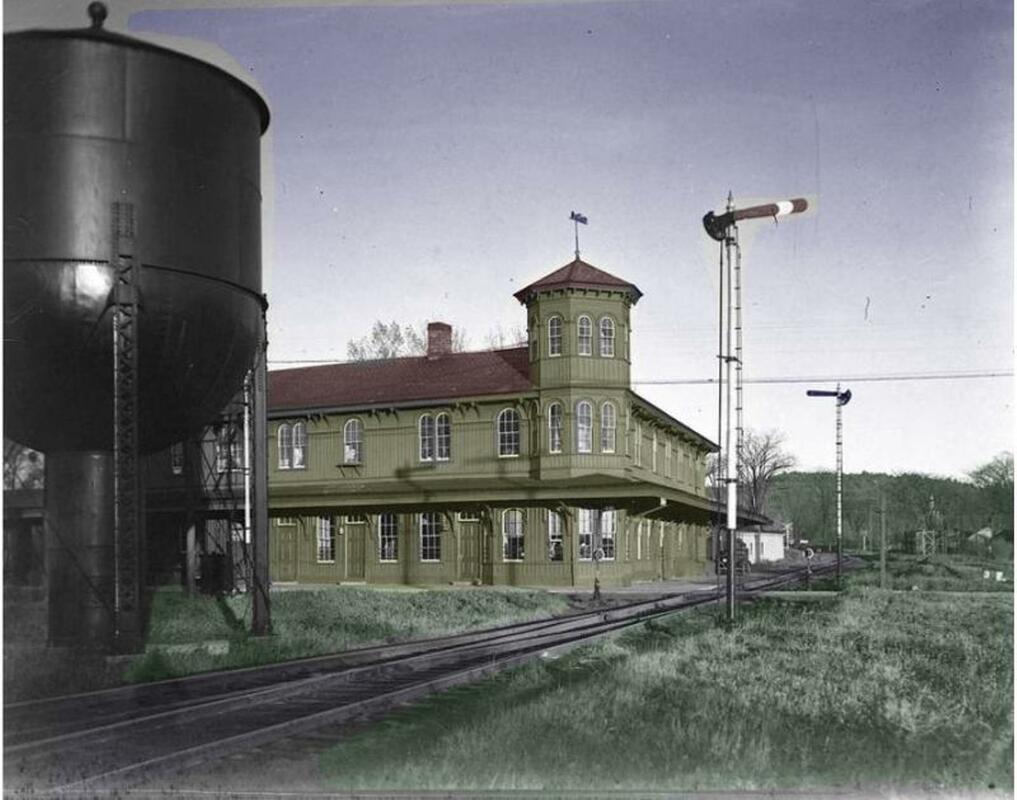
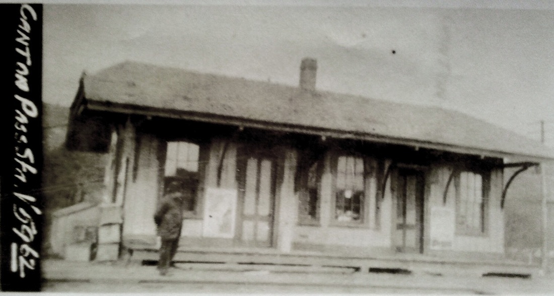
CANAAN2 [HRR/CW, 1872]
When the CW opened in 1871, the newspaper said that a union station was to be built by the two roads so passengers could make easy connections. With the Boston Daily Advertiser saying that the railroads were completing "a handsome and commodious building at Canaan for station purposes, to cost about $15,000" and the Pittsfield Sun reporting that the roof on the "mammoth depot at Canaan Junction" was being "slated" in August, a 12/6/1872 article in the Connecticut Western News," said that "the new Union Depot was completed on December 2, 1872. It is a grand structure indeed... The depot, so complete and elegant in every feature, was designed by Chief Engineer Shunk. The carpentry was under the supervision of G.H. Bundy of Lakeville, a general contractor, cabinetmaker, and maker of coffins. The masonry was done by Kilmer, of Canaan." Even when it was under construction in October, it was already being called "the model depot of Connecticut," though "Wallingford and Windsor people would probably dispute the claim," since attractive structures had just been put up in their towns. The two-story, L-shaped, board-and-batten structure had offices for both companies in the 90-ft wing adjacent to each railroad's track. A three-story tower dominated the 90-degree diamond crossing of the companies. The 1880 NY&NE appraisal of CW assets put the road's share of the value of this one at $6,000. Passenger service was discontinued in 1927 on the CNE and in 1971 on the Berkshire line but the building was still used for freight purposes by successor railroads. Heavily damaged by arson on 10/15/2001, CANAAN2 has been restored to her former elegance, thanks to many groups and individuals who appreciate the rich history this structure represents. The view in the photo on the right looks north up the HRR line. [REFS: HDC/12/14/1871/02; BDA/08/12/1872/02; PS/08/21/1872/02; HDC/10/26/1872/04; CW/NYNE1880; A37; D38,85; K115; R38][rev061313]
CANAAN VALLEY [> WHITING RIVER]

|

|
CANNON1 [D&N, 1852]
This station in the town of WILTON is not shown on the 1856FC map at left but it is seen east of the track on the 1868 Beer's map at right. This was an original D&N stop from 1852. The station burned in October, 1890, in a fire reported to have been arson. This is according to a newspaper article that, interestingly enough, is mistitled to read that the HRR freight station in South Norwalk, the byline town, had burned, which we first thought to mean WILSON POINT. The article text clarifies that the fire started in the grocery store "across the way" from what had to be the station here and soon took CANNON1. It said that the freight depot was destroyed, as well as the waiting room and telegraph station, in what was a combination depot perhaps similar in appearance to D&N stations BETHEL1 and GEORGETOWN1. [REFS: NHER/10/03/1890/01; SL34.4.33][rev011813]
This station in the town of WILTON is not shown on the 1856FC map at left but it is seen east of the track on the 1868 Beer's map at right. This was an original D&N stop from 1852. The station burned in October, 1890, in a fire reported to have been arson. This is according to a newspaper article that, interestingly enough, is mistitled to read that the HRR freight station in South Norwalk, the byline town, had burned, which we first thought to mean WILSON POINT. The article text clarifies that the fire started in the grocery store "across the way" from what had to be the station here and soon took CANNON1. It said that the freight depot was destroyed, as well as the waiting room and telegraph station, in what was a combination depot perhaps similar in appearance to D&N stations BETHEL1 and GEORGETOWN1. [REFS: NHER/10/03/1890/01; SL34.4.33][rev011813]

|
|

|
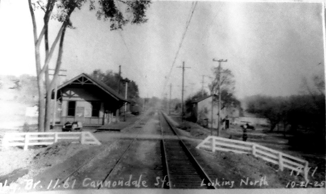
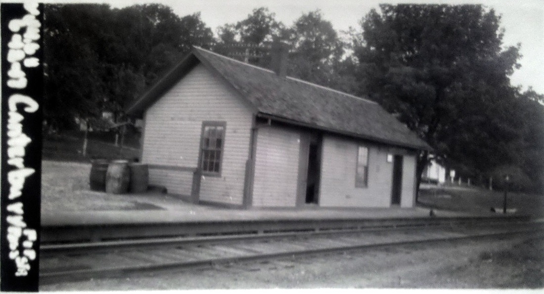
CANNON2 [HRR, 1892]
The second station was finished by May, 1892. The 9/30/1892 HRR annual report shows an expense of $1022.88 for the new depot. This stop had been named from the start for D&N builder Charles Cannon, who coincidentally died shortly after the new station was built. In December, 1915, the post office here was renamed so as to avoid confusion with Canaan, and the railroad followed suit by changing the name of the station to CANNONDALE. The PUC inspection photo at middle is dated 10/21/1925 and shows the new name in use. The structure still graces Metro North's Danbury line today in 2012. [REFS: NHER/10/22/1891/04; HRRAR54.1892.3; HC/06/09/1892/02; NHER/06/09/1892/04; HC/12/30/1892/06; SL34.4.33][rev102913]
The second station was finished by May, 1892. The 9/30/1892 HRR annual report shows an expense of $1022.88 for the new depot. This stop had been named from the start for D&N builder Charles Cannon, who coincidentally died shortly after the new station was built. In December, 1915, the post office here was renamed so as to avoid confusion with Canaan, and the railroad followed suit by changing the name of the station to CANNONDALE. The PUC inspection photo at middle is dated 10/21/1925 and shows the new name in use. The structure still graces Metro North's Danbury line today in 2012. [REFS: NHER/10/22/1891/04; HRRAR54.1892.3; HC/06/09/1892/02; NHER/06/09/1892/04; HC/12/30/1892/06; SL34.4.33][rev102913]
CANTERBURY1 [HP&F, 1854]
This stop, actually in the town of Plainfield, was established when the HP&F opened from Willimantic to Providence in 1854. We have no photo yet of whatever served as the first depot here. [rev012314]
This stop, actually in the town of Plainfield, was established when the HP&F opened from Willimantic to Providence in 1854. We have no photo yet of whatever served as the first depot here. [rev012314]

|
|
CANTERBURY2 [NY&NE, 1877?]
We have added this entry for a second station here because this may have been built with the "considerable improvements" that the railroad commissioners mention in their 1877 annual report. The photo on the right was taken in 1917. The shot on the left was found in the Images of America Canterbury book [p86]. It is reported to be taken in the 1920s with Dr. Helen Baldwin on the platform (dark dress?) waiting for a train to take her back to her New York City medical practice. It presents a bit of a mystery since the siding boards on this structure are vertical, whereas in the other photo they are horizontal. Was the station re-sided? Did the one in the 1917 photo burn and get replaced? We will inquire further. The last station to stand here was sold in 1929 when passenger service was discontinued. According to the book, the building was dismantled, moved and reassembled as a private residence. [REFS: CRC24.1877.20; LR]
We have added this entry for a second station here because this may have been built with the "considerable improvements" that the railroad commissioners mention in their 1877 annual report. The photo on the right was taken in 1917. The shot on the left was found in the Images of America Canterbury book [p86]. It is reported to be taken in the 1920s with Dr. Helen Baldwin on the platform (dark dress?) waiting for a train to take her back to her New York City medical practice. It presents a bit of a mystery since the siding boards on this structure are vertical, whereas in the other photo they are horizontal. Was the station re-sided? Did the one in the 1917 photo burn and get replaced? We will inquire further. The last station to stand here was sold in 1929 when passenger service was discontinued. According to the book, the building was dismantled, moved and reassembled as a private residence. [REFS: CRC24.1877.20; LR]
|
|

|
|

|
CANTON [CW, 1871; depot 1872]
An 1871 article said that, though this was open as a flag stop, the permanent location for this station had not yet been settled so we have put the opening in the following year, 1872. The 1880 NY&NE appraisal of CW property said there was a station in good condition here to serve both passengers and freight and valued it at $1500, the same they said the structure at BLOOMFIELD was worth. Nimke says it was built in 1873, that it later became a garage as pictured at lower left, and that it was still up in 1948. A building with similar lines and historic appearance situated nearby has been discounted as being this station still standing in 2012. The photo at lower right looks to be after it was hit by a train, possibly on 5/19/1917. In an article replete with interesting details, the Courant reported that Conductor Charles West and Engineer Edelman were "flying a freight car from the main line onto the siding. The car crashed into the corner of the station, knocking it askew. The switch where the cars are shunted from the main line is about 700 feet from the depot and the sidetrack runs upgrade terminating near the southeast corner of the station so the cars are pushed with considerable force. The freight chain became caught at the foot of the brake rod and the brakeman was unable to stop the car. Station agent G.B. Fenn and an American Telephone & Telegraph man were checking up some express in the corner of the station where the car struck. Agent Fenn heard the whistle for breaks (sic) and jumped for the door and the other man went out the other door, both men getting out of the station just as the crash came. The station has been bumped into several times before but this time it looks as if a new station would be needed. All the posts on the south side of the building next to the tracks are broken off. Three windows are smashed, part of the siding was sprung from away from the timbers, the doors that are shut cannot be opened and the doors that are open cannot be shut. One door opening into the office was lifted from the hinges and landed on the opposite side of the room. The stovepipes in both stoves were disconnected. The telegraph kept ticking on but the electric light wire was broken. The station was pushed about a foot and a half last winter but was jacked back into place. This time, it was moved three or four feet and it looks as if a new station would be necessary. The present structure was built in 1870 when the railroad was built." As far as we know this station, actually built in 1872, was never replaced. The frugality of the times apparently led the CNE to right this wrong. We do note the damage to the roof which would correspond to the southeast corner where the depot was struck. Canton, of course, was the home of the Gra-Rock Co., the third-largest beverage producer in the nation in the late 1920s. In 1927, it reportedly turned out 21,000,000 bottles of products like spring water, said in 1914 to be "the purest water that nature has ever produced," plus soft drinks and flavorings. For this reason, the application to abandon the CNE in 1932 was on all but the Collinsville-Canton section with the 1926 link with the Canal line providing an outlet for the beverage products. CNE rail was otherwise gone by 1938. The Canton Historical Museum [click here] has a great local history collection that was very helpful in this research and is well worth a visit. [REFS: HDC/12/14/1871/02; CW/NYNE1880; HC/05/20/1917/15; A39; D22; N3.23][rev040213]
An 1871 article said that, though this was open as a flag stop, the permanent location for this station had not yet been settled so we have put the opening in the following year, 1872. The 1880 NY&NE appraisal of CW property said there was a station in good condition here to serve both passengers and freight and valued it at $1500, the same they said the structure at BLOOMFIELD was worth. Nimke says it was built in 1873, that it later became a garage as pictured at lower left, and that it was still up in 1948. A building with similar lines and historic appearance situated nearby has been discounted as being this station still standing in 2012. The photo at lower right looks to be after it was hit by a train, possibly on 5/19/1917. In an article replete with interesting details, the Courant reported that Conductor Charles West and Engineer Edelman were "flying a freight car from the main line onto the siding. The car crashed into the corner of the station, knocking it askew. The switch where the cars are shunted from the main line is about 700 feet from the depot and the sidetrack runs upgrade terminating near the southeast corner of the station so the cars are pushed with considerable force. The freight chain became caught at the foot of the brake rod and the brakeman was unable to stop the car. Station agent G.B. Fenn and an American Telephone & Telegraph man were checking up some express in the corner of the station where the car struck. Agent Fenn heard the whistle for breaks (sic) and jumped for the door and the other man went out the other door, both men getting out of the station just as the crash came. The station has been bumped into several times before but this time it looks as if a new station would be needed. All the posts on the south side of the building next to the tracks are broken off. Three windows are smashed, part of the siding was sprung from away from the timbers, the doors that are shut cannot be opened and the doors that are open cannot be shut. One door opening into the office was lifted from the hinges and landed on the opposite side of the room. The stovepipes in both stoves were disconnected. The telegraph kept ticking on but the electric light wire was broken. The station was pushed about a foot and a half last winter but was jacked back into place. This time, it was moved three or four feet and it looks as if a new station would be necessary. The present structure was built in 1870 when the railroad was built." As far as we know this station, actually built in 1872, was never replaced. The frugality of the times apparently led the CNE to right this wrong. We do note the damage to the roof which would correspond to the southeast corner where the depot was struck. Canton, of course, was the home of the Gra-Rock Co., the third-largest beverage producer in the nation in the late 1920s. In 1927, it reportedly turned out 21,000,000 bottles of products like spring water, said in 1914 to be "the purest water that nature has ever produced," plus soft drinks and flavorings. For this reason, the application to abandon the CNE in 1932 was on all but the Collinsville-Canton section with the 1926 link with the Canal line providing an outlet for the beverage products. CNE rail was otherwise gone by 1938. The Canton Historical Museum [click here] has a great local history collection that was very helpful in this research and is well worth a visit. [REFS: HDC/12/14/1871/02; CW/NYNE1880; HC/05/20/1917/15; A39; D22; N3.23][rev040213]
|
|
|

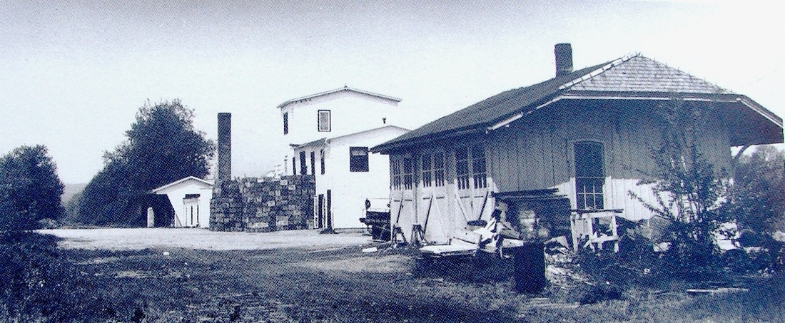
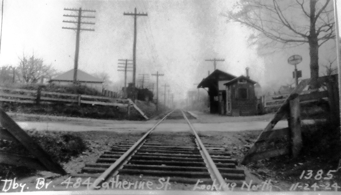
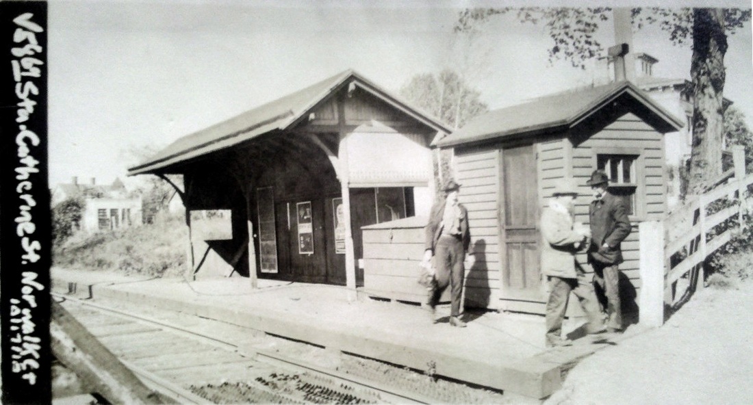
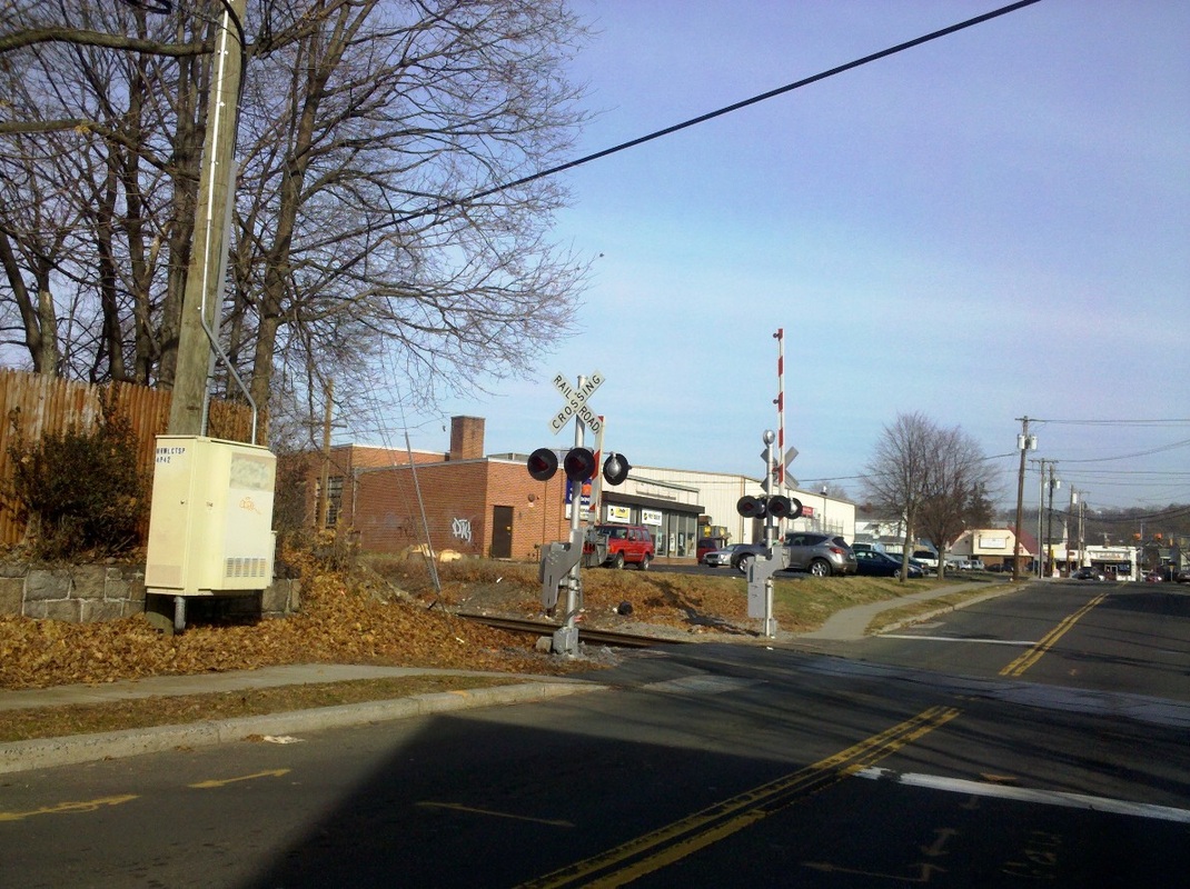
CATHERINE STREET [HRR, 1886]
The railroad commissioners noted the creation of this stop north of Norwalk's downtown in their 1886 annual report. It was probably established by the HRR to build traffic on the line after it leased the D&N in November of that year. The 1915 val map [lower right] shows that the shelter stood in the northeast quadrant of the grade crossing and the shot we took recently [lower left] replicates the view in the val photo at upper right. The PUC inspection shot at upper left is dated 11/24/1924. [REFS: CRC34.1886.57; RAM1908]
The railroad commissioners noted the creation of this stop north of Norwalk's downtown in their 1886 annual report. It was probably established by the HRR to build traffic on the line after it leased the D&N in November of that year. The 1915 val map [lower right] shows that the shelter stood in the northeast quadrant of the grade crossing and the shot we took recently [lower left] replicates the view in the val photo at upper right. The PUC inspection shot at upper left is dated 11/24/1924. [REFS: CRC34.1886.57; RAM1908]

|

|

|
CEDAR HILL1 [NHM&W, 1870; NYNH&H depot, 1889]
Cedar Hill Jct. in the FAIR HAVEN section of the Elm City had been a stop since the 1870 opening of the NHM&W, but it was located about a half mile north of here until the Air Line connection was moved south to join the Shore Line in 1884. There was a call for a small station to be built at this location in 1885, when a letter to the newspaper said it would be a convenience for people wishing to visit East Rock, Whitneyville, Fair Haven, or just the northern part of New Haven. Interestingly, Pres. Clark himself was riding a train early in 1888 when it began letting people off here and, in response to his inquiry, he was told that "certain trains stopped there"(!) to accommodate passengers who lived in the area and did not want to ride any farther south. Surveying the dangerous situation at the junction of the three divisions, he decided it was indeed a good place for a station. By August, men were working on the foundation with completion expected in the late fall. An 1889 Palladium article gives quite a detailed description of the 65x22-ft building with its slate roof that projected 14 feet out all around it and necessitated the numerous supporting posts that give this station a somewhat unique appearance. The article said it expected the station to open in February. The construction unfortunately forestalled a street extension that New Haven had been contemplating for some time and one report said that the railroad built CEDAR HILL1 in the dead of night to get the jump on the city. The August, 1888 Register article also mentioned that the NYNH&H had purchased a large tract of the salt marsh here at State and James Sts. which would be filled in for freight yards. This would ultimately become the location of the Conn. Co. car barns by 1911 and still is Connecticut Transit property today. The image at upper left was one of three photographs in a late 1909 newspaper article describing the past, present, and future stations here. In it you can make out the shape of the depot that seems to match the center photograph. The other photos show CEDAR HILL1 looking pretty spiffy. At upper right is an interesting southward view of the four-tracked Hartford main with the James St. bridge in the foreground, work that dated to 1888. The companion shot on the lower left shows a buggy approaching the bridge and, in the distance, one can see the connection track for the Manufacturer's Street Railway going south behind the station. The Shore Line track is no longer seen since it was moved northward in the double-tracking of 1892-1894 to a new junction of the three divisions. [REFS: PTH418.1871.20; NHER/12/29/1884/01; NHER/01/26/1885/01; NHDP/11/17/1887/01; CRC36.1888.19; NHER/02/18/1888/01; NHER/08/31/1888/04; NHDP/10/23/1888/04; NHDP/10/30/1888 /04; NHDP/01/29/1889/??; NHAR18.1888.5; CRC37.1889.18; NHER/11/16/1892/01; NHU/10/24/1909/09; NHER/10/30/1909/02; C122: 1881TT]
Cedar Hill Jct. in the FAIR HAVEN section of the Elm City had been a stop since the 1870 opening of the NHM&W, but it was located about a half mile north of here until the Air Line connection was moved south to join the Shore Line in 1884. There was a call for a small station to be built at this location in 1885, when a letter to the newspaper said it would be a convenience for people wishing to visit East Rock, Whitneyville, Fair Haven, or just the northern part of New Haven. Interestingly, Pres. Clark himself was riding a train early in 1888 when it began letting people off here and, in response to his inquiry, he was told that "certain trains stopped there"(!) to accommodate passengers who lived in the area and did not want to ride any farther south. Surveying the dangerous situation at the junction of the three divisions, he decided it was indeed a good place for a station. By August, men were working on the foundation with completion expected in the late fall. An 1889 Palladium article gives quite a detailed description of the 65x22-ft building with its slate roof that projected 14 feet out all around it and necessitated the numerous supporting posts that give this station a somewhat unique appearance. The article said it expected the station to open in February. The construction unfortunately forestalled a street extension that New Haven had been contemplating for some time and one report said that the railroad built CEDAR HILL1 in the dead of night to get the jump on the city. The August, 1888 Register article also mentioned that the NYNH&H had purchased a large tract of the salt marsh here at State and James Sts. which would be filled in for freight yards. This would ultimately become the location of the Conn. Co. car barns by 1911 and still is Connecticut Transit property today. The image at upper left was one of three photographs in a late 1909 newspaper article describing the past, present, and future stations here. In it you can make out the shape of the depot that seems to match the center photograph. The other photos show CEDAR HILL1 looking pretty spiffy. At upper right is an interesting southward view of the four-tracked Hartford main with the James St. bridge in the foreground, work that dated to 1888. The companion shot on the lower left shows a buggy approaching the bridge and, in the distance, one can see the connection track for the Manufacturer's Street Railway going south behind the station. The Shore Line track is no longer seen since it was moved northward in the double-tracking of 1892-1894 to a new junction of the three divisions. [REFS: PTH418.1871.20; NHER/12/29/1884/01; NHER/01/26/1885/01; NHDP/11/17/1887/01; CRC36.1888.19; NHER/02/18/1888/01; NHER/08/31/1888/04; NHDP/10/23/1888/04; NHDP/10/30/1888 /04; NHDP/01/29/1889/??; NHAR18.1888.5; CRC37.1889.18; NHER/11/16/1892/01; NHU/10/24/1909/09; NHER/10/30/1909/02; C122: 1881TT]

|

|
CEDAR HILL2 [NYNH&H, 1909]
The map at the left appeared in the Register late in 1905 and shows that the proposed street extension was up for discussion again. For better connections with the Fair Haven section, the city wanted to lengthen Humphrey St., either building through the station property to meet Lombard St. or somewhat lower to meet Alton St. The Manufacturer's Street Railway had its yard, not shown on the map, exactly in this lower area. Controversy about disrupting that and about how the railroad would bridge Humphrey St. would cause delays until 1911 in finishing the project. The railroad considered abandoning the location completely, with trolley service now cutting into local steam railroad traffic. The public, however, objected and the railroad commissioners ruled that a new station had to be built. During the transition, CEDAR HILL1 was closed and the Union article cited above said that a "makeshift" station, "an old passenger car and a disposed tool car coupled on a siding and bearing in handsome gilt and black the words 'Cedar Hill'" was in use. In this dark image, we can see the outline of the coach and tool car and we can also just make out the NYNH&H lettering. [REFS: NHER/12/17/1905]
The map at the left appeared in the Register late in 1905 and shows that the proposed street extension was up for discussion again. For better connections with the Fair Haven section, the city wanted to lengthen Humphrey St., either building through the station property to meet Lombard St. or somewhat lower to meet Alton St. The Manufacturer's Street Railway had its yard, not shown on the map, exactly in this lower area. Controversy about disrupting that and about how the railroad would bridge Humphrey St. would cause delays until 1911 in finishing the project. The railroad considered abandoning the location completely, with trolley service now cutting into local steam railroad traffic. The public, however, objected and the railroad commissioners ruled that a new station had to be built. During the transition, CEDAR HILL1 was closed and the Union article cited above said that a "makeshift" station, "an old passenger car and a disposed tool car coupled on a siding and bearing in handsome gilt and black the words 'Cedar Hill'" was in use. In this dark image, we can see the outline of the coach and tool car and we can also just make out the NYNH&H lettering. [REFS: NHER/12/17/1905]
Dave Peters Collection
|
|

|
CEDAR HILL3 [NYNH&H, 1910]
These images are of the station as built [left] and as projected [right] that appeared in the newspaper with the Union article cited above. Construction was expected to start on October 11, 1909 with contractor William Patterson in charge and completion anticipated in about four months. According to the Evening Leader, plans were drawn up by C.W. Lord, architect for the New Haven road, and the building was to have a concrete foundation, walls of terra cotta and brick, a green tiled roof, and stone trimmings. It was to be "heated by steam, with up to date plumbing" and "fitted with the largest electric globes." The cost was expected to be about $6,500. This station stood on the west side of the tracks, between Humphrey and James Sts. The Register reported in April, 1910 that the new station would open on the 25th. It said the 'little Chinese doll house' was "perhaps the neatest station anywhere on the road outside the small suburban stations on the New York and Harlem divisions." The val map shows the layout in 1915. This station has several trains stopping in 1923 but none on our 1937TT, though it was pressed into service again briefly after the 1938 hurricane when high water in the East Cut prevented trains from going to Hartford. The completion of this project was just before the construction of the "mammoth roundhouse" and massive redevelopment of Cedar Hill yard immediately to the north, reported in 1911 by the Courant to be costing between $3.5 and $5M. [REFS: NHEL/10/08/1909/13; NHAR38.1909.7: in progress; NHER/02/14/1910/01; NHER/04/08/1910/09; NHAR40.1911.11: done; HC/03/04/1911/07; NL6.2.4; SL9.3.10][rev121512]
These images are of the station as built [left] and as projected [right] that appeared in the newspaper with the Union article cited above. Construction was expected to start on October 11, 1909 with contractor William Patterson in charge and completion anticipated in about four months. According to the Evening Leader, plans were drawn up by C.W. Lord, architect for the New Haven road, and the building was to have a concrete foundation, walls of terra cotta and brick, a green tiled roof, and stone trimmings. It was to be "heated by steam, with up to date plumbing" and "fitted with the largest electric globes." The cost was expected to be about $6,500. This station stood on the west side of the tracks, between Humphrey and James Sts. The Register reported in April, 1910 that the new station would open on the 25th. It said the 'little Chinese doll house' was "perhaps the neatest station anywhere on the road outside the small suburban stations on the New York and Harlem divisions." The val map shows the layout in 1915. This station has several trains stopping in 1923 but none on our 1937TT, though it was pressed into service again briefly after the 1938 hurricane when high water in the East Cut prevented trains from going to Hartford. The completion of this project was just before the construction of the "mammoth roundhouse" and massive redevelopment of Cedar Hill yard immediately to the north, reported in 1911 by the Courant to be costing between $3.5 and $5M. [REFS: NHEL/10/08/1909/13; NHAR38.1909.7: in progress; NHER/02/14/1910/01; NHER/04/08/1910/09; NHAR40.1911.11: done; HC/03/04/1911/07; NL6.2.4; SL9.3.10][rev121512]
CEMETERY SIDING [> SPRINGDALE CEMETERY]
CENTERBROOK [NYNH&H, c1945]
This appears to have been later bus stop on a 6/8/1947TT, six miles north of ESSEX but is seen as a dot for a stop on the CV on an 1899 map. We need to check with Max Miller on this. [REFS: RAM1899]
CENTERBROOK [NYNH&H, c1945]
This appears to have been later bus stop on a 6/8/1947TT, six miles north of ESSEX but is seen as a dot for a stop on the CV on an 1899 map. We need to check with Max Miller on this. [REFS: RAM1899]
|

|

|
CENTERVILLE1 [NH&N, 1848]
Often seen spelled as CENTREVILLE, this was an original station on the NH&N in the town of Hamden and is indicated by the red arrow on the 1868 map at upper left. It is usually designated on timetables as a flag stop. We have no photo yet of whatever structure may have been here. The red X on the map at upper right shows its location today along what was originally the path of the old Farmington Canal that paralleled Whitney Ave., then Cheshire Tpke. The current property lines that we have shown with the dashed red line still reflect the route that once loped northeast through this part of Hamden. We also noted that the access road to the subdivision west of Whitney Ave. on today's map seems to correspond exactly to the path to the CENTERVILLE1 depot that swung south as well to go the spoon factory on the 1868 map. The red arrow on the ca. 1940 aerial photo at lower left shows what appears to be the old ROW behind Hamden's 1924 Memorial Town Hall.
Often seen spelled as CENTREVILLE, this was an original station on the NH&N in the town of Hamden and is indicated by the red arrow on the 1868 map at upper left. It is usually designated on timetables as a flag stop. We have no photo yet of whatever structure may have been here. The red X on the map at upper right shows its location today along what was originally the path of the old Farmington Canal that paralleled Whitney Ave., then Cheshire Tpke. The current property lines that we have shown with the dashed red line still reflect the route that once loped northeast through this part of Hamden. We also noted that the access road to the subdivision west of Whitney Ave. on today's map seems to correspond exactly to the path to the CENTERVILLE1 depot that swung south as well to go the spoon factory on the 1868 map. The red arrow on the ca. 1940 aerial photo at lower left shows what appears to be the old ROW behind Hamden's 1924 Memorial Town Hall.

|

|
|
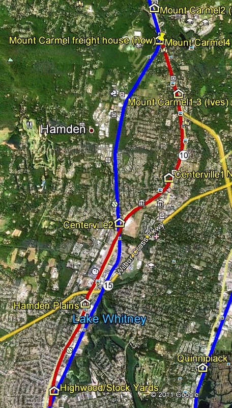
CENTERVILLE2 [NH&N, 1880]
When the Canal line was relocated in 1880, the stop for this part of Hamden had to be changed because CENTERVILLE1 was on the abandoned section along Whitney Ave. Reports that CENTERVILLE2 was where the Arthur Murray dance studio is today at 2838 Old Dixwell Ave. must be in error, though that address is along the old ROW. The correct location is seen on the 1893 map at left, east of the track and just above the crossing of Dixwell Ave. which was at grade in 1880. The overpass, with plans dated 1920 in the RG 041 map collection at CSL, is part of the Farmington Canal Heritage Greenway today. This flag stop was approved by the railroad commissioners for abandonment on 1/24/1905 because of trolley competition cutting into railroad patronage. We have no photo yet of CENTERVILLE2. The 1915 val maps show the original canal and railroad pretty much all along the NH&N even where there were no remnants when the surveyors visited 65 years after the canal was discontinued. The snippet at middle shows the area around the Wilbur Cross Pkwy, with the original alignment at the blue arrow, here on the west side of Dixwell Ave., and the 1880 ROW to the east at the red arrow. The image at right is from our CTTRAXMAP, the link to which can be found on Track 11, and shows the realignment that began just below Putnam Ave. and ended at West Woods Rd. in Mount Carmel. The original ROW, as best we can determine it from the val maps, is traced in red and the 1880 realignment is the blue line. [REFS: RRC24.67 (7/8/1880); RRC24.82 (7/20/1881); RRC24.249 (1/24/1905); CRC53.1905.5; PUC Map 765]
When the Canal line was relocated in 1880, the stop for this part of Hamden had to be changed because CENTERVILLE1 was on the abandoned section along Whitney Ave. Reports that CENTERVILLE2 was where the Arthur Murray dance studio is today at 2838 Old Dixwell Ave. must be in error, though that address is along the old ROW. The correct location is seen on the 1893 map at left, east of the track and just above the crossing of Dixwell Ave. which was at grade in 1880. The overpass, with plans dated 1920 in the RG 041 map collection at CSL, is part of the Farmington Canal Heritage Greenway today. This flag stop was approved by the railroad commissioners for abandonment on 1/24/1905 because of trolley competition cutting into railroad patronage. We have no photo yet of CENTERVILLE2. The 1915 val maps show the original canal and railroad pretty much all along the NH&N even where there were no remnants when the surveyors visited 65 years after the canal was discontinued. The snippet at middle shows the area around the Wilbur Cross Pkwy, with the original alignment at the blue arrow, here on the west side of Dixwell Ave., and the 1880 ROW to the east at the red arrow. The image at right is from our CTTRAXMAP, the link to which can be found on Track 11, and shows the realignment that began just below Putnam Ave. and ended at West Woods Rd. in Mount Carmel. The original ROW, as best we can determine it from the val maps, is traced in red and the 1880 realignment is the blue line. [REFS: RRC24.67 (7/8/1880); RRC24.82 (7/20/1881); RRC24.249 (1/24/1905); CRC53.1905.5; PUC Map 765]

|

Dave Peters Collection
|
|
CENTRAL VILLAGE [N&W, 1840]
The location is seen on the 1856WC map. The stop was established in 1840 in the town of Plainfield by the N&W. Since this structure is so large, we think that there was an earlier station but we have no evidence and so have not listed it as of yet.
The location is seen on the 1856WC map. The stop was established in 1840 in the town of Plainfield by the N&W. Since this structure is so large, we think that there was an earlier station but we have no evidence and so have not listed it as of yet.
|
|
CHARTER OAK PARK1 [HP&F, 1874]
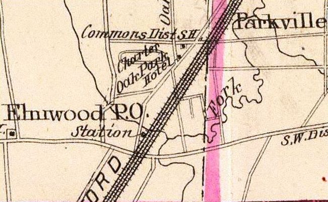
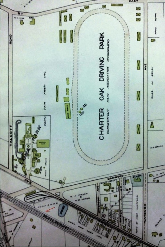
This HARTFORD stop was created for the horse-racing track and adjacent park grounds that opened in 1874. On opening, the track facilities were said to be second to none in the country, the grandstand reportedly modeled on the one at Saratoga. The 60-ft wide New Park Ave. was cited as "a good approach for driving" to be used by those not coming by train to this attraction that was said to be the pride of Hartford, even though it was just outside the city limits. Additional rail service was supposedly coming from a new station being established on the NYNH&H near the entrance to the park, likely the OAKWOOD depot. Two platforms apparently served as CHARTER OAK PARK1 and trains began stopping here thereafter for fairs and periodic special events. The 1893 map [right] clarifies the location of the park between the PARKVILLE and the ELMWOOD stops and the other map shows the streets today. [REFS: HDC/07/21/1871/02; HDC/07/30/1874/02; MDC/08/17/1874/02; HDC/08/25/1874/02; HDC/06/22/1880/02; HC/02/09/1906/01]
This HARTFORD stop was created for the horse-racing track and adjacent park grounds that opened in 1874. On opening, the track facilities were said to be second to none in the country, the grandstand reportedly modeled on the one at Saratoga. The 60-ft wide New Park Ave. was cited as "a good approach for driving" to be used by those not coming by train to this attraction that was said to be the pride of Hartford, even though it was just outside the city limits. Additional rail service was supposedly coming from a new station being established on the NYNH&H near the entrance to the park, likely the OAKWOOD depot. Two platforms apparently served as CHARTER OAK PARK1 and trains began stopping here thereafter for fairs and periodic special events. The 1893 map [right] clarifies the location of the park between the PARKVILLE and the ELMWOOD stops and the other map shows the streets today. [REFS: HDC/07/21/1871/02; HDC/07/30/1874/02; MDC/08/17/1874/02; HDC/08/25/1874/02; HDC/06/22/1880/02; HC/02/09/1906/01]

|
|
|
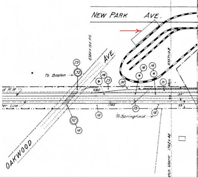
CHARTER OAK PARK2 [NYNH&H, c1910]
The station seen in this 1916 photo looks to be similar to CEDAR HILL3 and others built in the early 1900s. It could only have stood at the end of the trolley loop along the railroad track but the 1909 map [right] shows no separate railroad station at the red arrow on the NYNH&H parcel and the the 1915 val map [middle] shows none either. The flag stop is shown on a 1914TT and it is on the official list of stations in 1928 as well. Aside from regular local traffic, Luna Park, which began operations here in the summer of 1906, the race track, and the annual Connecticut State Fair each must have drawn large numbers of rail and trolley customers who, we are left to assume, all used the single station. The NYNH&H's adjacent OAKWOOD stop, nowhere to be found on the maps either, probably was eliminated between 1895 and 1898 with the takeover of the NY&NE. Luna Park reportedly closed in 1918 and the race track shut down in 1940, according to the book Hartford Trolleys [p50]. The group in the photo is a Pratt and Whitney outing, an eerie foreshadowing of the company's later purchase of the park to move its operations here from downtown Hartford. [REFS: HC/01/24/1940/06][rev100212]
The station seen in this 1916 photo looks to be similar to CEDAR HILL3 and others built in the early 1900s. It could only have stood at the end of the trolley loop along the railroad track but the 1909 map [right] shows no separate railroad station at the red arrow on the NYNH&H parcel and the the 1915 val map [middle] shows none either. The flag stop is shown on a 1914TT and it is on the official list of stations in 1928 as well. Aside from regular local traffic, Luna Park, which began operations here in the summer of 1906, the race track, and the annual Connecticut State Fair each must have drawn large numbers of rail and trolley customers who, we are left to assume, all used the single station. The NYNH&H's adjacent OAKWOOD stop, nowhere to be found on the maps either, probably was eliminated between 1895 and 1898 with the takeover of the NY&NE. Luna Park reportedly closed in 1918 and the race track shut down in 1940, according to the book Hartford Trolleys [p50]. The group in the photo is a Pratt and Whitney outing, an eerie foreshadowing of the company's later purchase of the park to move its operations here from downtown Hartford. [REFS: HC/01/24/1940/06][rev100212]

CHASES MILLS [NYNH&H, c1900]
This apparently was a factory stop in the extreme northwestern part of Waterbury in the 1900s. It appears on a list that the current NRR uses on their excursion tickets but they have been unable to identify the date of the timetable the list was based on. This grainy photo shows an old coach parked on a siding and notations in the margins indicate that this is the passenger platform here in the Waterville section of town. The NYNH&H used coaches elsewhere for industrial stops, e.g. BELAMOSE, for temporary facilities after fires, e.g. BOLTON1 and DERBY3, and for expanded facilities where needed, e.g. SCOTLAND2.
This apparently was a factory stop in the extreme northwestern part of Waterbury in the 1900s. It appears on a list that the current NRR uses on their excursion tickets but they have been unable to identify the date of the timetable the list was based on. This grainy photo shows an old coach parked on a siding and notations in the margins indicate that this is the passenger platform here in the Waterville section of town. The NYNH&H used coaches elsewhere for industrial stops, e.g. BELAMOSE, for temporary facilities after fires, e.g. BOLTON1 and DERBY3, and for expanded facilities where needed, e.g. SCOTLAND2.
CHATHAM [> EAST HAMPTON]
CHENEYVILLE [> SOUTH MANCHESTER]
CHENEYVILLE [> SOUTH MANCHESTER]

|
|
|
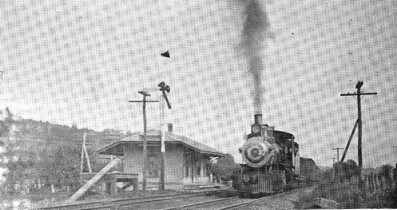
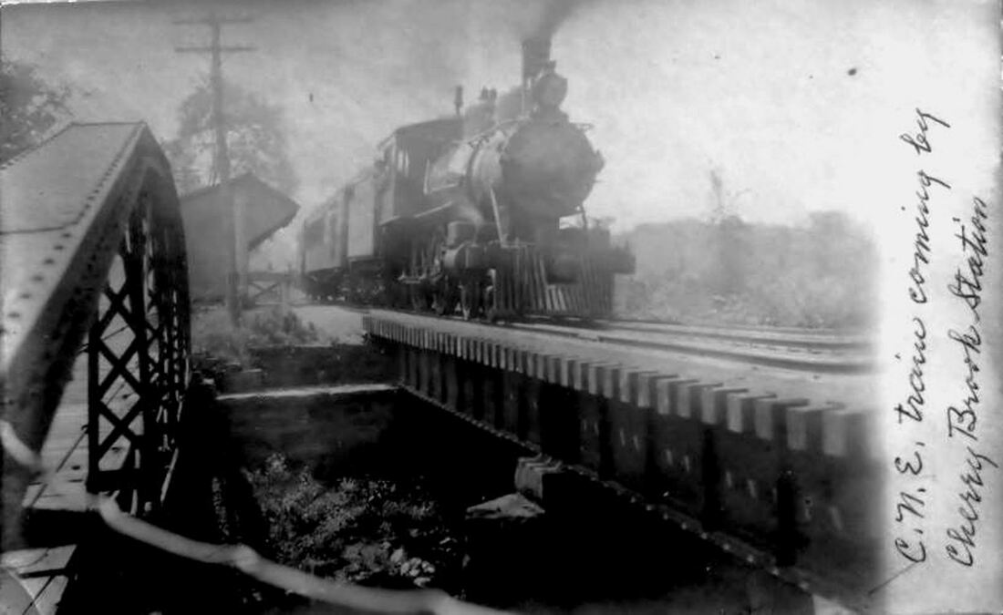
CHERRY BROOK1 [CW, c1876; depot 1879]
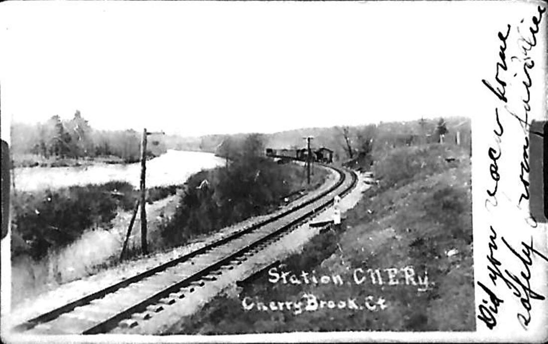
This was a CW flag station in the town of Canton. Though the photo at left seems to say 1872 in the lower right corner, this stop was not on timetables or station lists in 1871-1872 and the earliest reference to it we find is on the first of the railroad commissioners maps, issued in 1876. The 1880 appraisal of CW property by the NY&NE said there was a shed here to serve both passengers and freight and valued it at $100. The photo at [2] shows a train speeding west past the small open-faced structure. The corner of the small depot can be seen on the left above the highway-bridge guard rail over Cherry Brook which flowed alongside the station and into the Farmington River. In reporting on an accident in 1893, the newspaper said "the depot at Cherry Brook is now a thing of the past. The lordly pile now lies piled up to one side of the P. & R. track, a total wreck. This state of things is due to the fact that last Thursday night [1/5/1893] an eastbound freight train ran off the track at the Cherry Brook station and collided with the depot... This idea of having trains run into the depots is an entirely new one and is bold in its originality; we can only say 'what next?'" The shot at [3] looks west at the station in the distance, with the river on the south side of the railroad line. All three images show the jutted overhang of the front roof line which would not appear when the shattered station was rebuilt. [REFS: HDC/12/21/1871/02; RRM1876; GED1879; 1880 CW/NYNE; 1882TT: yes; HDC/01/10/1893/07; CWN/01/12/1893/03][rev010319]
This was a CW flag station in the town of Canton. Though the photo at left seems to say 1872 in the lower right corner, this stop was not on timetables or station lists in 1871-1872 and the earliest reference to it we find is on the first of the railroad commissioners maps, issued in 1876. The 1880 appraisal of CW property by the NY&NE said there was a shed here to serve both passengers and freight and valued it at $100. The photo at [2] shows a train speeding west past the small open-faced structure. The corner of the small depot can be seen on the left above the highway-bridge guard rail over Cherry Brook which flowed alongside the station and into the Farmington River. In reporting on an accident in 1893, the newspaper said "the depot at Cherry Brook is now a thing of the past. The lordly pile now lies piled up to one side of the P. & R. track, a total wreck. This state of things is due to the fact that last Thursday night [1/5/1893] an eastbound freight train ran off the track at the Cherry Brook station and collided with the depot... This idea of having trains run into the depots is an entirely new one and is bold in its originality; we can only say 'what next?'" The shot at [3] looks west at the station in the distance, with the river on the south side of the railroad line. All three images show the jutted overhang of the front roof line which would not appear when the shattered station was rebuilt. [REFS: HDC/12/21/1871/02; RRM1876; GED1879; 1880 CW/NYNE; 1882TT: yes; HDC/01/10/1893/07; CWN/01/12/1893/03][rev010319]
|
|
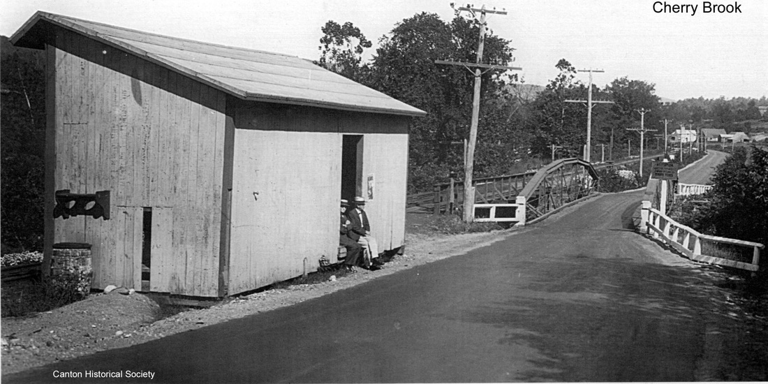
CHERRY BROOK2 [PR&NE, 1893]
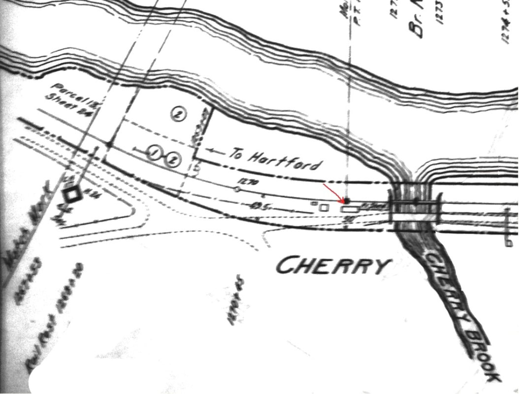
The last line of the 1893 CWN article cited above said that "a later report is that the depot has been set up again." This photo and others like it were taken after the rebuilding, with the shortened front roof line now giving the depot more of a saltbox look. The 1916 val map at [2] shows this station as simply CHERRY per the ICC's 1915 safety order that favored one-word, non-redundant station designations. It also seems to have this structure labeled as 'Frt Shed' and, in fact, this depot looked long enough to cover some merchandise as well as passengers in both of its incarnations. This location was the scene of numerous mishaps before and after CHERRY BROOK2 was built but the structure survived and was reportedly sold and removed in 1930 [LR]. [REFS: CWN/01/12/1893/03; NYHT/08/14/1895/09; NHER/08/18/1900/03; D24][rev010318]
The last line of the 1893 CWN article cited above said that "a later report is that the depot has been set up again." This photo and others like it were taken after the rebuilding, with the shortened front roof line now giving the depot more of a saltbox look. The 1916 val map at [2] shows this station as simply CHERRY per the ICC's 1915 safety order that favored one-word, non-redundant station designations. It also seems to have this structure labeled as 'Frt Shed' and, in fact, this depot looked long enough to cover some merchandise as well as passengers in both of its incarnations. This location was the scene of numerous mishaps before and after CHERRY BROOK2 was built but the structure survived and was reportedly sold and removed in 1930 [LR]. [REFS: CWN/01/12/1893/03; NYHT/08/14/1895/09; NHER/08/18/1900/03; D24][rev010318]
|

Cheshire Historical Society
|

National Archives
|
|
|
|
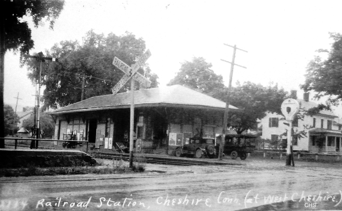
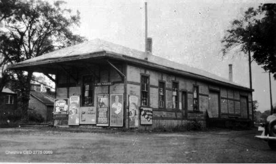
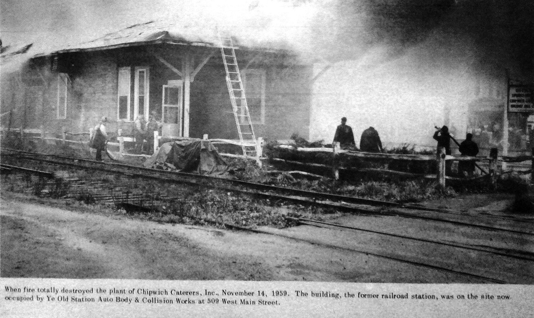
CHESHIRE [NH&N, 1848]
The depot is marked, appropriately enough, with the letter 'C' in the shot at [1] from the 1882 Bailey bird's-eye map [click here]. Built in 1848 by the NY&NH which was then leasing the Canal line, this structure looks like its cousins, SIMSBURY1 and GRANBY, both of which are still extant. The railroad commissioners said this one was remodeled in 1886. The heavy scalloped brackets were presumably replaced at that time by the stick-style braces seen in later photos and the structure was apparently expanded as well, since it looks considerably smaller on the map than it does in later shots. The image at [2] has a handsome locomotive letting off steam as it heads north across West Main St. The val photo at [3] is dated 9/25/1916. The image at [4] is Lewis H. Benton photo #2134 taken in June, 1928; from the 1930s. The shot at [5] dates to perhaps the 1940s. The newspaper item at [6] clarifies the fate of this depot. At age 111, it was destroyed by fire on 11/14/1959 in its last incarnation as Chipwich Caterers. Many thanks to the Cheshire Historical Society [click here] for permission to use their photos posted in several listings. [REFS: CRC34.1886.9][rev042618]
The depot is marked, appropriately enough, with the letter 'C' in the shot at [1] from the 1882 Bailey bird's-eye map [click here]. Built in 1848 by the NY&NH which was then leasing the Canal line, this structure looks like its cousins, SIMSBURY1 and GRANBY, both of which are still extant. The railroad commissioners said this one was remodeled in 1886. The heavy scalloped brackets were presumably replaced at that time by the stick-style braces seen in later photos and the structure was apparently expanded as well, since it looks considerably smaller on the map than it does in later shots. The image at [2] has a handsome locomotive letting off steam as it heads north across West Main St. The val photo at [3] is dated 9/25/1916. The image at [4] is Lewis H. Benton photo #2134 taken in June, 1928; from the 1930s. The shot at [5] dates to perhaps the 1940s. The newspaper item at [6] clarifies the fate of this depot. At age 111, it was destroyed by fire on 11/14/1959 in its last incarnation as Chipwich Caterers. Many thanks to the Cheshire Historical Society [click here] for permission to use their photos posted in several listings. [REFS: CRC34.1886.9][rev042618]
|

|

|

|
|
|

Robert Schreitmueller map
CHESHIRE JUNCTION [NYNH&H, 1902]
We confine ourselves almost exclusively to passenger stops but we have included this one because of its uniqueness and the fascinating information found in a 5/23/1902 Southington Phoenix article covering the 5/18/1902 opening of the so-called Cheshire loop. Pres. Hall described it in the 1902 annual report as "a short and inexpensive cut-off about 2,000 feet in length, which makes a direct route and furnishes frequent service between New Haven and Waterbury..." Indeed, it cut travel time from 90 minutes via the NH&D/NRR almost in half to 50 minutes via the Canal line. This, of course, was a very smart move, one which could have been done by the NYNH&H years earlier. According to the Phoenix article several changes had been made at the Cheshire station "... on account of the new route. Mr. Murdock, formerly assistant station manager, has been transferred to the 'Tower' at the junction of the 'loop' and the main line..." [and] the work [at Cheshire] has been more than doubled..." with the increased traffic. Initially there were five daily trains as seen on the 6/26/1904 timetable at [1]. The underlined 'R' on the 1905 ETT at [2] shows this as a registry station which meant that all trains had to stop for the conductor to sign in; the 'D' shows a day-only agent, possibly our Mr. Murdock. A Meriden Morning Record article tells of a narrowly avoided collision on 1/14/1905 when a substitute dispatcher "... at the station just this side [i.e. west] of Cheshire" gave a Waterbury-bound loop train the all-clear with a Meriden-bound train having yet to pass. The engineer of the 'loop' train was able to back up and avoided the collision by a mere 200 feet. Seemingly in an admission of defeat, loop passenger service ended on 10/08/1905, two months after the 8/9/1905 opening of the Cheshire Street Railway that paralleled the MW&CR to the Brass City. Ironically, 1905 is the year the loop first appears on the timetable map seen at [3]. The NYNH&H's ultimate response to this competition was a takeover of CSR's parent, the Connecticut Railway & Lighting Co. in November, 1906. Failing that, Pres. Mellen would testify to the ICC in 1914 [click here] that he had been authorized by the board of directors on 6/8/1906 to double-track and electrify the line from Mt. Carmel to Waterbury. The loop is seen as late as the 1914 timetable map we have in our collection but it is not even shown as abandoned on the 6/30/1915 val map at [4], though the parcels in the property-title section show 1902 purchase dates. The photo at [5] looks south and shows the MW&CR bridge over the Canal line, with the retaining wall and west abutment on the right. The shot at [6] looks at the western abutment with the Canal line track still in place in 1985. CHESHIRE JUNCTION and its 'tower' were physically located, according to our reading of the Phoenix article, right at the west end of the loop seen in yellow on the map at [7]. Exactly when the loop track was lifted and what happened to the 'tower' are tantalizing questions yet unanswered in the history of this intriguing location. All may have remained in place until 1924 when the line from Waterbury to Meriden was abandoned. Curiously, as we have said, all paper evidence is gone; it is as if the loop never existed! Was its short life such an embarrassment to the railroad? Physical evidence does remain: the arc-shaped berm can still be seen today in 2022 behind the homes that were built east of Peck Lane after the loop's removal. [REFS: NHAR31.1902.5; CRC50.1902.19; HC/01/28/1902/02; NHER/05/16/1902/00; NHETT36 (5/18/1902): agent 7-7 daily, 8-9 p.m. Sundays; MMR/03/09/1904/03; HC/05/07/1904/07; MMR/01/17/1905/03; NHPTT40a (6/26/1904); NHETT42a (7/2/1905); HC/08/02/1905/14; HC/08/11/1905/03; HC/08/17/1905/02; NHJC/10/09/1905/08; CRC53. 1905.31; HC/06/16/1906/12; NYT/11/02/1906/09; NHPTT Form 220 (6/29/1914); Interstate Commerce Commission No. 6569, Report of Investigation of the Financial Transactions of the New York, New Haven & Hartford Railroad Company, vol 1, p859; Blakeslee, Lines West, p5 (Camm ed.)][rev042618, 042122]
We confine ourselves almost exclusively to passenger stops but we have included this one because of its uniqueness and the fascinating information found in a 5/23/1902 Southington Phoenix article covering the 5/18/1902 opening of the so-called Cheshire loop. Pres. Hall described it in the 1902 annual report as "a short and inexpensive cut-off about 2,000 feet in length, which makes a direct route and furnishes frequent service between New Haven and Waterbury..." Indeed, it cut travel time from 90 minutes via the NH&D/NRR almost in half to 50 minutes via the Canal line. This, of course, was a very smart move, one which could have been done by the NYNH&H years earlier. According to the Phoenix article several changes had been made at the Cheshire station "... on account of the new route. Mr. Murdock, formerly assistant station manager, has been transferred to the 'Tower' at the junction of the 'loop' and the main line..." [and] the work [at Cheshire] has been more than doubled..." with the increased traffic. Initially there were five daily trains as seen on the 6/26/1904 timetable at [1]. The underlined 'R' on the 1905 ETT at [2] shows this as a registry station which meant that all trains had to stop for the conductor to sign in; the 'D' shows a day-only agent, possibly our Mr. Murdock. A Meriden Morning Record article tells of a narrowly avoided collision on 1/14/1905 when a substitute dispatcher "... at the station just this side [i.e. west] of Cheshire" gave a Waterbury-bound loop train the all-clear with a Meriden-bound train having yet to pass. The engineer of the 'loop' train was able to back up and avoided the collision by a mere 200 feet. Seemingly in an admission of defeat, loop passenger service ended on 10/08/1905, two months after the 8/9/1905 opening of the Cheshire Street Railway that paralleled the MW&CR to the Brass City. Ironically, 1905 is the year the loop first appears on the timetable map seen at [3]. The NYNH&H's ultimate response to this competition was a takeover of CSR's parent, the Connecticut Railway & Lighting Co. in November, 1906. Failing that, Pres. Mellen would testify to the ICC in 1914 [click here] that he had been authorized by the board of directors on 6/8/1906 to double-track and electrify the line from Mt. Carmel to Waterbury. The loop is seen as late as the 1914 timetable map we have in our collection but it is not even shown as abandoned on the 6/30/1915 val map at [4], though the parcels in the property-title section show 1902 purchase dates. The photo at [5] looks south and shows the MW&CR bridge over the Canal line, with the retaining wall and west abutment on the right. The shot at [6] looks at the western abutment with the Canal line track still in place in 1985. CHESHIRE JUNCTION and its 'tower' were physically located, according to our reading of the Phoenix article, right at the west end of the loop seen in yellow on the map at [7]. Exactly when the loop track was lifted and what happened to the 'tower' are tantalizing questions yet unanswered in the history of this intriguing location. All may have remained in place until 1924 when the line from Waterbury to Meriden was abandoned. Curiously, as we have said, all paper evidence is gone; it is as if the loop never existed! Was its short life such an embarrassment to the railroad? Physical evidence does remain: the arc-shaped berm can still be seen today in 2022 behind the homes that were built east of Peck Lane after the loop's removal. [REFS: NHAR31.1902.5; CRC50.1902.19; HC/01/28/1902/02; NHER/05/16/1902/00; NHETT36 (5/18/1902): agent 7-7 daily, 8-9 p.m. Sundays; MMR/03/09/1904/03; HC/05/07/1904/07; MMR/01/17/1905/03; NHPTT40a (6/26/1904); NHETT42a (7/2/1905); HC/08/02/1905/14; HC/08/11/1905/03; HC/08/17/1905/02; NHJC/10/09/1905/08; CRC53. 1905.31; HC/06/16/1906/12; NYT/11/02/1906/09; NHPTT Form 220 (6/29/1914); Interstate Commerce Commission No. 6569, Report of Investigation of the Financial Transactions of the New York, New Haven & Hartford Railroad Company, vol 1, p859; Blakeslee, Lines West, p5 (Camm ed.)][rev042618, 042122]
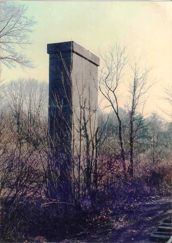
|

|

|
Just below CHESHIRE JUNCTION, the Cheshire Street Rwy crossed over the Canal line north of the CHESHIRE station on West Main St. The color shots show the remains in 1985, both the monolithic central pier and the eastern abutment. These, plus the western abutment, are all still extant in 2022 and have been identified by signage on the Farmington Canal Heritage Greenway. The Charles Rufus Harte photo at right looks north at a Waterbury-bound car crossing the bridge on 6/10/1927, with a stretch of the Farmington Canal still running on the eastern side of the railroad line. Recollections are that the trolley men used to let the cars roar down the incline before bringing them to a safe stop at Scott's Junction opposite Waverly Inn on Maple Ave.
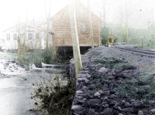
|
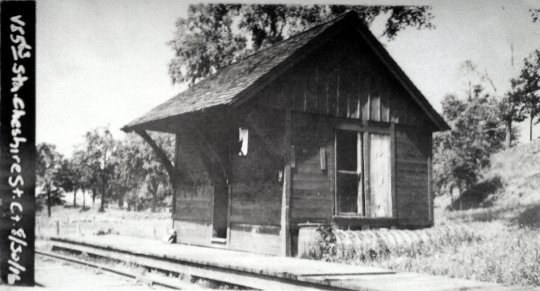
National Archives
|
|

Connecticut Historical Society
|

Connecticut Historical Society
|
|
CHESHIRE STREET [M&W, 1888, opened as HOUGHS MILL]
This was a stop in the town of Cheshire, just over the Meriden border. The photo at [1] is likely the earliest, showing this small station south of the track beyond the factory complex at Hough's Mill. The valuation photo at [2] is dated 8/30/1916 and shows the depot north of the track, as reflected [red arrow] on the 6/30/1915 valuation map at [3]. This was likely done when the grade crossing just west of the mill was eliminated. Called CHESHIRE STREET thereafter to reflect the highway name changes in the area, it is not on our 1900TT but it is on the 1907TT, with two weekday trains stopping here daily each way. By the 1911TT, there is a lone 7:30 a.m. train from Meriden and a single 5:10 p.m. return from Dublin St., with all the intermediate stations marked as flag stops. This last train was probably run to accommodate commuting workers, especially those bound for the jewelry factory that operated here ca. 1912 when an extra car had to be put on. Rail service from Meriden to Waterbury ended in 1917 and the track came out in 1924. The view at [4], with an enlargement at [5], looks east toward the Quinnipiac River and the station. The vantage point must be from the Cheshire St. overhead highway bridge which crossed both the railroad and the river. The opposing westward view is seen at [7] in shots juxtaposed by our talented colleague, Al Weaver, who also has done a number of 'ghost' photos for this website. The best could do on the removal date for the overhead bridge is ca. 1958; there is a street-level bridge now. The Track 11 Google Earth map snippet at [6] looks north at the entire area. The val map at [3] looks south. [REFS: NHER/03/26/1890/03; R1.671; S14,26+][rev050722]
This was a stop in the town of Cheshire, just over the Meriden border. The photo at [1] is likely the earliest, showing this small station south of the track beyond the factory complex at Hough's Mill. The valuation photo at [2] is dated 8/30/1916 and shows the depot north of the track, as reflected [red arrow] on the 6/30/1915 valuation map at [3]. This was likely done when the grade crossing just west of the mill was eliminated. Called CHESHIRE STREET thereafter to reflect the highway name changes in the area, it is not on our 1900TT but it is on the 1907TT, with two weekday trains stopping here daily each way. By the 1911TT, there is a lone 7:30 a.m. train from Meriden and a single 5:10 p.m. return from Dublin St., with all the intermediate stations marked as flag stops. This last train was probably run to accommodate commuting workers, especially those bound for the jewelry factory that operated here ca. 1912 when an extra car had to be put on. Rail service from Meriden to Waterbury ended in 1917 and the track came out in 1924. The view at [4], with an enlargement at [5], looks east toward the Quinnipiac River and the station. The vantage point must be from the Cheshire St. overhead highway bridge which crossed both the railroad and the river. The opposing westward view is seen at [7] in shots juxtaposed by our talented colleague, Al Weaver, who also has done a number of 'ghost' photos for this website. The best could do on the removal date for the overhead bridge is ca. 1958; there is a street-level bridge now. The Track 11 Google Earth map snippet at [6] looks north at the entire area. The val map at [3] looks south. [REFS: NHER/03/26/1890/03; R1.671; S14,26+][rev050722]

|
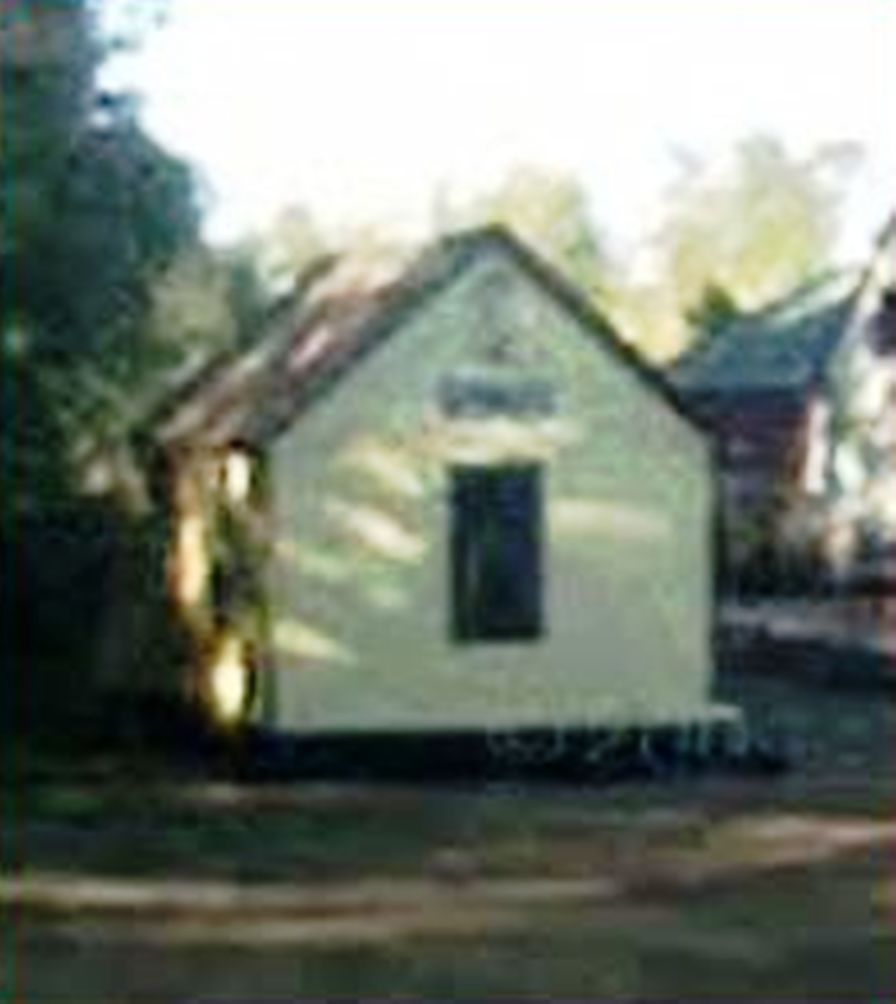
|

|
CHESTER1 [CV, 1871]
The Valley Railroad has this building in the photo as their yard office at the former site of the EAST HADDAM passenger station. According to Max Miller, CV historian, it is the remaining portion of the 1871 CHESTER1 depot and John Roy reiterates this. This depot stood above the cove at the northeast corner of the Dock Rd. crossing, as shown on the map at [1]. In 1874 the railroad wanted to eliminate it in favor of the LORDS FARM flag stop just to the south on the map. See both stops on the 1871 timetable. The railroad commissioners gave their approval but the town challenged the decision. The case went all the way to the state Supreme Court and the abandonment was forestalled. With an amended plan, CHESTER1 was discontinued and the railroad commissioners said that "trains now make South Chester their only stopping place in that town. This station, according to Max, closed on 11/5/1874 and went on to become part of a private residence until the remaining portion was donated back to the Valley RR. [REFS: HDC/08/25/1871/02; DC/09/15/1874/02; 41 Conn. 348; CRC22.1875.19; R40]
The Valley Railroad has this building in the photo as their yard office at the former site of the EAST HADDAM passenger station. According to Max Miller, CV historian, it is the remaining portion of the 1871 CHESTER1 depot and John Roy reiterates this. This depot stood above the cove at the northeast corner of the Dock Rd. crossing, as shown on the map at [1]. In 1874 the railroad wanted to eliminate it in favor of the LORDS FARM flag stop just to the south on the map. See both stops on the 1871 timetable. The railroad commissioners gave their approval but the town challenged the decision. The case went all the way to the state Supreme Court and the abandonment was forestalled. With an amended plan, CHESTER1 was discontinued and the railroad commissioners said that "trains now make South Chester their only stopping place in that town. This station, according to Max, closed on 11/5/1874 and went on to become part of a private residence until the remaining portion was donated back to the Valley RR. [REFS: HDC/08/25/1871/02; DC/09/15/1874/02; 41 Conn. 348; CRC22.1875.19; R40]
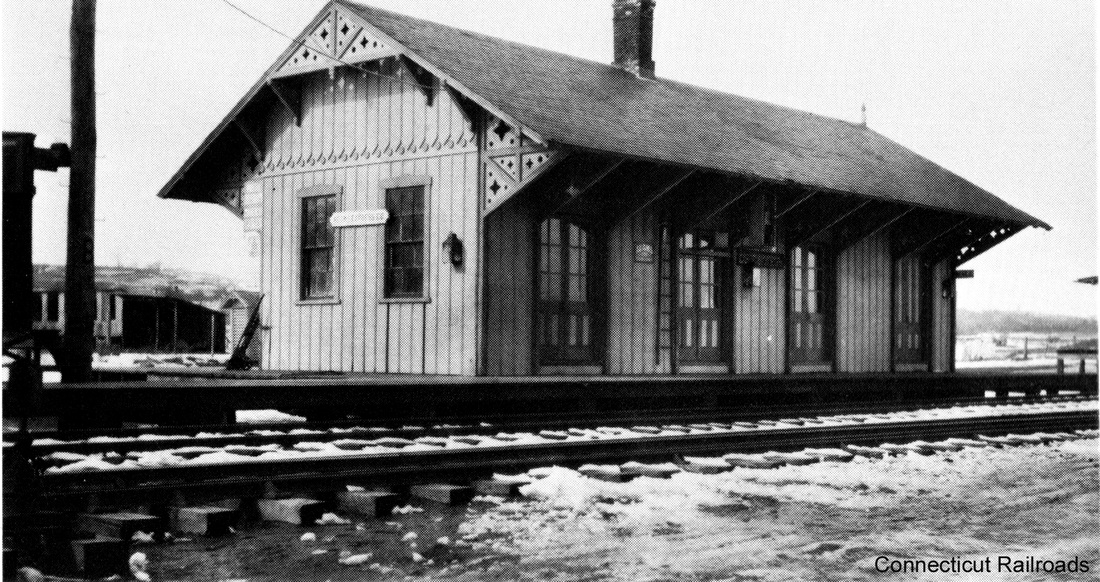
|
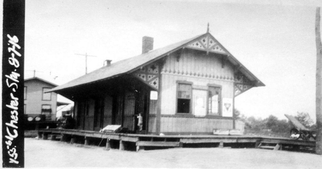
Dave Peters Collection
|

|

CHESTER2 [CV, 1871, opened as LORDS FARM]
This started out as a flag stop on the 1871 timetable above, a "station in the same town a short distance below" CHESTER1 on opening day. The first mention of this depot, also known as SOUTH CHESTER, is in a newspaper article which indicates that tickets were being sold here as of July 14, 1872. A humorous incident was noted when some newlyweds were expected at this stop where a "chariot" made from a hack attached to a "couple of gaily decorated oxen" awaited to take them to their honeymoon destination. The pair mistakenly de-trained at CHESTER1 and had to be transported by a gentleman named 'Bummer' to meet their wedding entourage! The controversy over which depot would remain was resolved in 1874 when this one was chosen and CHESTER1 abandoned. The photo at [4] is CHESTER2 in its present incarnation as a private residence on Grote Rd., its enlarged girth apparently due to pushing out the walls under the overhang and the adding a brick facing onto the original Carpenter Gothic structure. [REFS: HDC/08/25/1871/02; MDC/08/14/1872/02; HDC/11/13/1872/04; HDC/10/23/1874/02; HDC/01/20/1877/04][rev080317; 070722]
This started out as a flag stop on the 1871 timetable above, a "station in the same town a short distance below" CHESTER1 on opening day. The first mention of this depot, also known as SOUTH CHESTER, is in a newspaper article which indicates that tickets were being sold here as of July 14, 1872. A humorous incident was noted when some newlyweds were expected at this stop where a "chariot" made from a hack attached to a "couple of gaily decorated oxen" awaited to take them to their honeymoon destination. The pair mistakenly de-trained at CHESTER1 and had to be transported by a gentleman named 'Bummer' to meet their wedding entourage! The controversy over which depot would remain was resolved in 1874 when this one was chosen and CHESTER1 abandoned. The photo at [4] is CHESTER2 in its present incarnation as a private residence on Grote Rd., its enlarged girth apparently due to pushing out the walls under the overhang and the adding a brick facing onto the original Carpenter Gothic structure. [REFS: HDC/08/25/1871/02; MDC/08/14/1872/02; HDC/11/13/1872/04; HDC/10/23/1874/02; HDC/01/20/1877/04][rev080317; 070722]
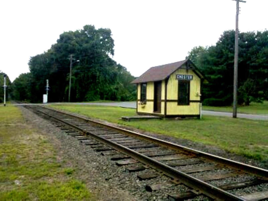
|
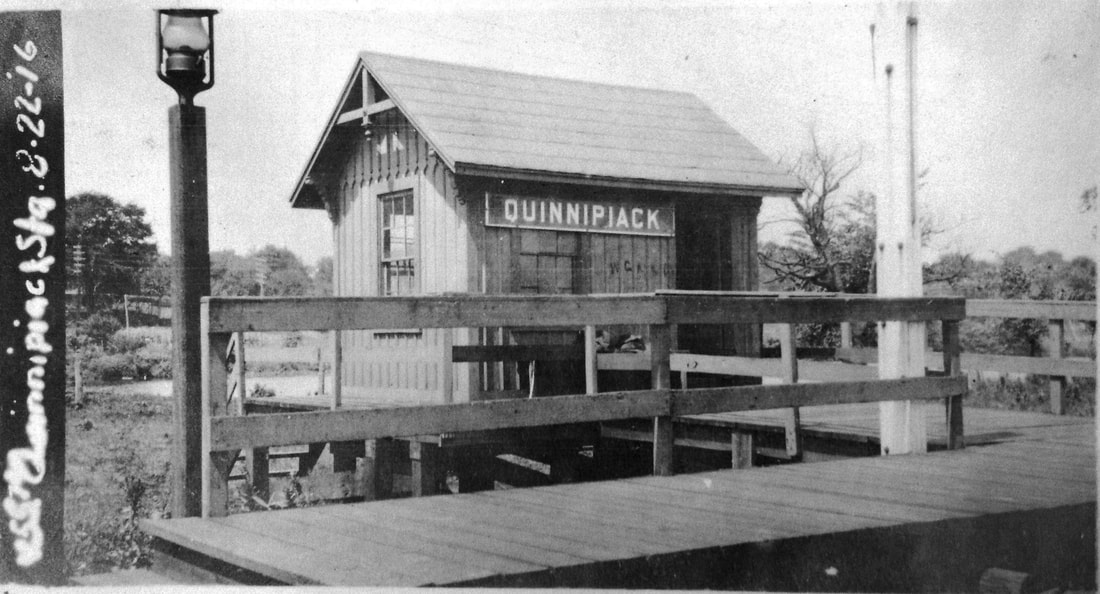
National Archives
|
|
|
|
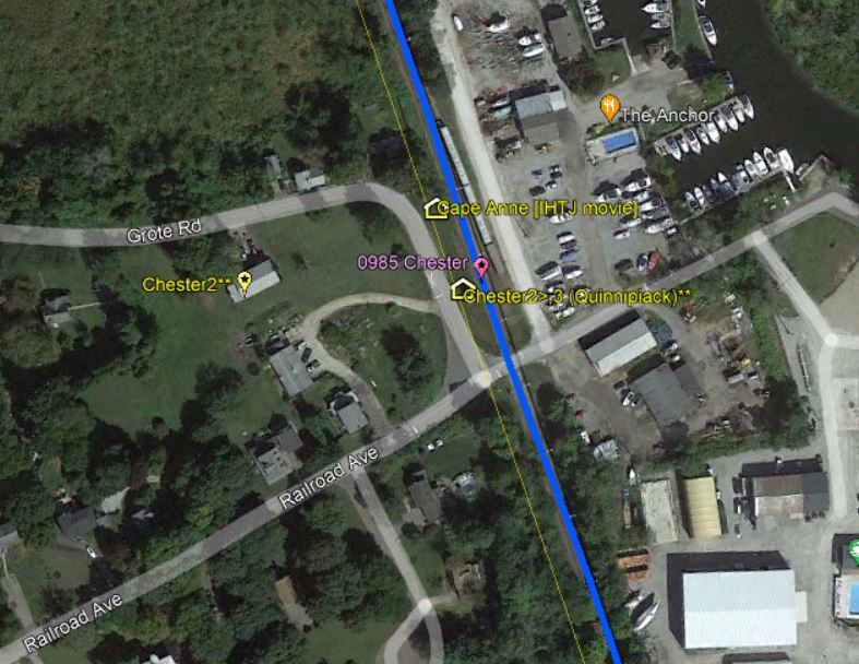
|
CHESTER3 [VRR, 1976]
CHESTER3 was formerly the QUINNIPIACK station in Hamden on the Hartford line. It was donated in 1975 to the Valley RR which restored it in 1976 and placed at the foot of Railroad Ave. in 1977. Previously this was the site of CHESTER2 which had been moved up along the intersecting Grote St. to become a private residence some years earlier. See preceding entry. Our photo at [1] was taken on 8/2/2010. The valuation shot at [2] is dated 8/22/1916 and shows the small depot in its original incarnation. At [3] VRR No. 40 blasts past the restored structure with a train on 6/9/2018. Quite a bit of filming took place here in 1958 for the movie It Happened to Jane, opening credit at [4], which starred Doris Day and Jack Lemmon. Released the next year, it has now become iconic for its Connecticut railroad scenes, including the MILLDALE2 depot on the Canal line in Southington, now operated as museum which celebrates Ms. Day's presence on 6/30/1958. See that entry. The 'Cape Anne' station, purpose-built for the film, appears in many scenes. The Budd car seen at [5] on 6/8/1958 is likely functioning as real-life transportation. It does not appear in the movie. Top billing may well go to the last surviving NYNH&H steam locomotive, No. 3016, which plays Eastern & Portland No. 97. The snippet from our Track 11 Google Earth map shows where Cape Anne stood as well as the origiinal and current locations of CHESTER2. [REFS: HC/08/05/1977/20D; R84][rev050722]
CHESTER3 was formerly the QUINNIPIACK station in Hamden on the Hartford line. It was donated in 1975 to the Valley RR which restored it in 1976 and placed at the foot of Railroad Ave. in 1977. Previously this was the site of CHESTER2 which had been moved up along the intersecting Grote St. to become a private residence some years earlier. See preceding entry. Our photo at [1] was taken on 8/2/2010. The valuation shot at [2] is dated 8/22/1916 and shows the small depot in its original incarnation. At [3] VRR No. 40 blasts past the restored structure with a train on 6/9/2018. Quite a bit of filming took place here in 1958 for the movie It Happened to Jane, opening credit at [4], which starred Doris Day and Jack Lemmon. Released the next year, it has now become iconic for its Connecticut railroad scenes, including the MILLDALE2 depot on the Canal line in Southington, now operated as museum which celebrates Ms. Day's presence on 6/30/1958. See that entry. The 'Cape Anne' station, purpose-built for the film, appears in many scenes. The Budd car seen at [5] on 6/8/1958 is likely functioning as real-life transportation. It does not appear in the movie. Top billing may well go to the last surviving NYNH&H steam locomotive, No. 3016, which plays Eastern & Portland No. 97. The snippet from our Track 11 Google Earth map shows where Cape Anne stood as well as the origiinal and current locations of CHESTER2. [REFS: HC/08/05/1977/20D; R84][rev050722]
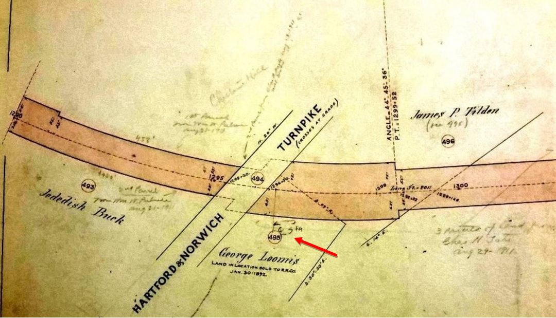
|
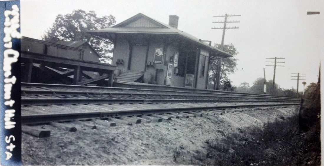
|
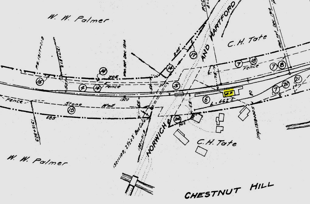
|
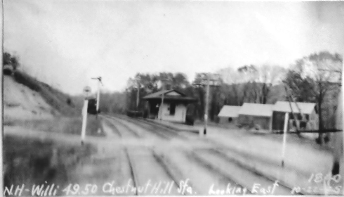
|
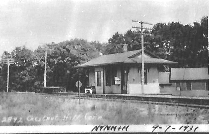
|
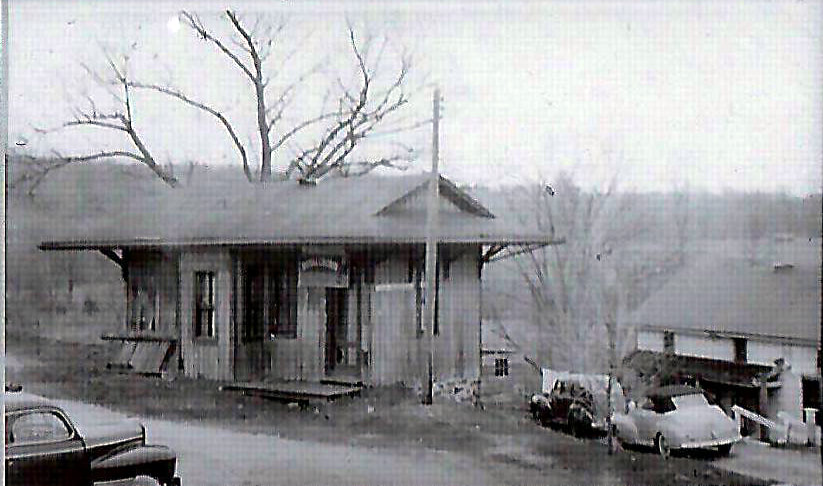
|
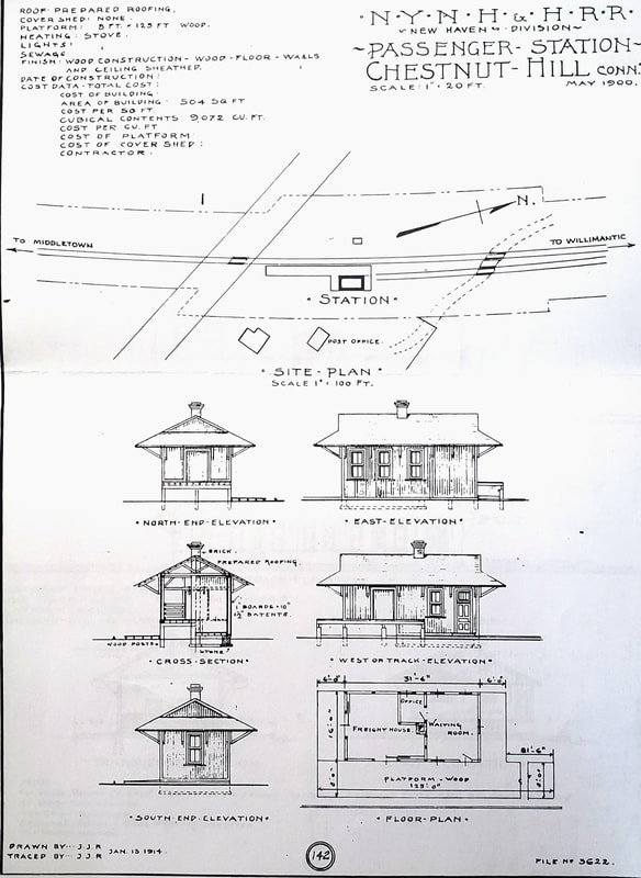 Al Lawrence Collection
CHESTNUT HILL [NHW&W, 1873, opened as LIBERTY HILL]
This stop was in the town of Columbia just over the line from Lebanon. Apparently there was no depot and not even a platform here until 1880, a cause of complaint to the railroad commissioners by citizens of both towns that resulted in one being built. The NHM&W started regular service on 8/12/1873 and began carrying mail as well, this stop being named for the nearby Liberty Hill post office in Lebanon. The depot was built in the southeast quadrant of the Hartford-Norwich Turnpike, today's CT Rte 87, grade crossing on land sold to the railroad by George Loomis. Part of the deal may have been that Loomis became station agent since his death in 1892 caused the paper to note that he had been agent for many years. Our red arrow points to the 'E Sta' pencil notation on the 1886 official ROW map at [1]. The name of this stop was changed from LIBERTY HILL to CHESTNUT HILL effective 11/1/1884 per order of Supt. Shepard to coincide with the establishment of a new post office at the station here, which the U.S. Official Postal Guide of January, 1884 shows for the first time. An 1898 newspaper article states that the Chestnut Hill post office was "located in the Air Line Railroad station" at that time. Not surprisingly perhaps, the widowed Mrs. Loomis was the postmistress, as well as station agent! The Air Line was straightened and relocated in a massive 1911-1914 improvement project and this depot may have been shifted slightly at that time. The 6/13/1917 valuation photo at [2] looks westward and shows the separate freight platform with steps down and a ramp up the freight room in the combination depot building. The val map at [3] shows the depot and the layout of the grounds as of 6/30/1915. The PUC shot at [4] looks east on 10/22/1925. The image at [5] was taken on 9/7/1931 by Lewis H. Benton, his #2842; the handwriting belongs to Irving N. Drake, fellow photographer and driver on the pair's jaunts. Three weekday and one Sunday train still stopped for riders here in 1923 but by 1927 most passenger service ended on the Air Line. The depot building was sold on 6/1/1938 for $50 but the name of the buyer is illegible in the 1938/1939 Status of Structures List; its ultimate fate thereafter is unknown but the photo at [6] shows the building still standing probably in the 1950s. CHESTNUT HILL is still on the Station Numbers list of 10/15/1944 and it is unclear exactly when freight service ended at this stop. Apples, milk and eggs were once shipped in quantity from here, 2500 dozen of the latter in April, 1909. The line from Cobalt to Willimantic was abandoned in 1965 and the tracks were torn up by November of that year. The 1/13/1914 architectural drawing at [7] shows the floor plan and building dimensions. This copy was found in the papers of the late Ed Sweeny of Norwood, MA and supplied to us by long-time TCS contributor Richard Fleischer of Newton Centre, MA. [REFS: HDC/07/21/1873/02; HDC/08/13/1873/04; RRC12.60ff (12/16/1878ff): no platform or depot; CRC27.1880.27; NB/04/28/1880/??; 1881TT=LH; NHER/10/17/1884/04; NHJC/07/14/1892/05; HC/09/03/1898/11; HC/05/11/1909/15; RRC12.223 (5/12/1909); LWTT12/2/1923; HC/07/23/1950/06; HC/11/07/1965/10A; C122; K90,92][rev080717, 103121]
This stop was in the town of Columbia just over the line from Lebanon. Apparently there was no depot and not even a platform here until 1880, a cause of complaint to the railroad commissioners by citizens of both towns that resulted in one being built. The NHM&W started regular service on 8/12/1873 and began carrying mail as well, this stop being named for the nearby Liberty Hill post office in Lebanon. The depot was built in the southeast quadrant of the Hartford-Norwich Turnpike, today's CT Rte 87, grade crossing on land sold to the railroad by George Loomis. Part of the deal may have been that Loomis became station agent since his death in 1892 caused the paper to note that he had been agent for many years. Our red arrow points to the 'E Sta' pencil notation on the 1886 official ROW map at [1]. The name of this stop was changed from LIBERTY HILL to CHESTNUT HILL effective 11/1/1884 per order of Supt. Shepard to coincide with the establishment of a new post office at the station here, which the U.S. Official Postal Guide of January, 1884 shows for the first time. An 1898 newspaper article states that the Chestnut Hill post office was "located in the Air Line Railroad station" at that time. Not surprisingly perhaps, the widowed Mrs. Loomis was the postmistress, as well as station agent! The Air Line was straightened and relocated in a massive 1911-1914 improvement project and this depot may have been shifted slightly at that time. The 6/13/1917 valuation photo at [2] looks westward and shows the separate freight platform with steps down and a ramp up the freight room in the combination depot building. The val map at [3] shows the depot and the layout of the grounds as of 6/30/1915. The PUC shot at [4] looks east on 10/22/1925. The image at [5] was taken on 9/7/1931 by Lewis H. Benton, his #2842; the handwriting belongs to Irving N. Drake, fellow photographer and driver on the pair's jaunts. Three weekday and one Sunday train still stopped for riders here in 1923 but by 1927 most passenger service ended on the Air Line. The depot building was sold on 6/1/1938 for $50 but the name of the buyer is illegible in the 1938/1939 Status of Structures List; its ultimate fate thereafter is unknown but the photo at [6] shows the building still standing probably in the 1950s. CHESTNUT HILL is still on the Station Numbers list of 10/15/1944 and it is unclear exactly when freight service ended at this stop. Apples, milk and eggs were once shipped in quantity from here, 2500 dozen of the latter in April, 1909. The line from Cobalt to Willimantic was abandoned in 1965 and the tracks were torn up by November of that year. The 1/13/1914 architectural drawing at [7] shows the floor plan and building dimensions. This copy was found in the papers of the late Ed Sweeny of Norwood, MA and supplied to us by long-time TCS contributor Richard Fleischer of Newton Centre, MA. [REFS: HDC/07/21/1873/02; HDC/08/13/1873/04; RRC12.60ff (12/16/1878ff): no platform or depot; CRC27.1880.27; NB/04/28/1880/??; 1881TT=LH; NHER/10/17/1884/04; NHJC/07/14/1892/05; HC/09/03/1898/11; HC/05/11/1909/15; RRC12.223 (5/12/1909); LWTT12/2/1923; HC/07/23/1950/06; HC/11/07/1965/10A; C122; K90,92][rev080717, 103121]
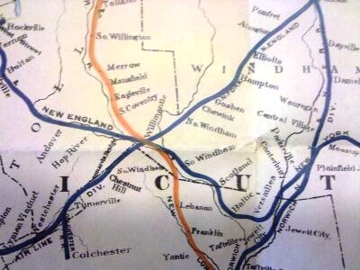
|

|
CHEWINK [NY&NE, c1882]
The ca. 1902 railroad commissioners map at left appears to show that this was a stop east of NORTH WINDHAM. When it was created and for what purpose if any it served is unknown and we have not seen it on any timetables. A newspaper article mentions the collision of two freight trains "at Chewink turnout, Goshen," which places it in the town of Chaplin. Chewink Rd. on the present day map is the most likely location of this stop at the intersection of what is now the Air Line Rail Trail. [REFS: NHER/12/11/1882/01; CRC31.1884.19]
The ca. 1902 railroad commissioners map at left appears to show that this was a stop east of NORTH WINDHAM. When it was created and for what purpose if any it served is unknown and we have not seen it on any timetables. A newspaper article mentions the collision of two freight trains "at Chewink turnout, Goshen," which places it in the town of Chaplin. Chewink Rd. on the present day map is the most likely location of this stop at the intersection of what is now the Air Line Rail Trail. [REFS: NHER/12/11/1882/01; CRC31.1884.19]