Track 12: CT Passenger Stations, G
See TCS Home Page links for notes, abbreviations, and sources.
Use Track 11 map link to locate stations, rail and trolley lines, and POIs.
Use Track 11 map link to locate stations, rail and trolley lines, and POIs.

|

|
|
|
|

|
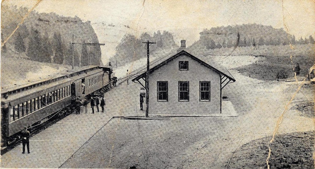
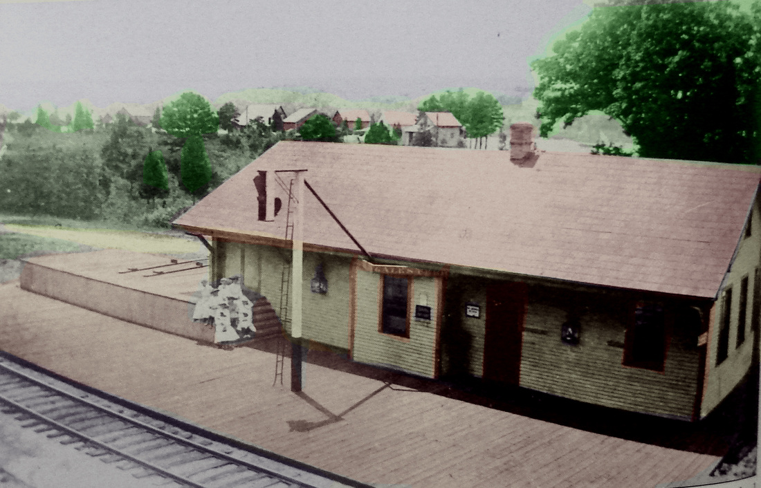
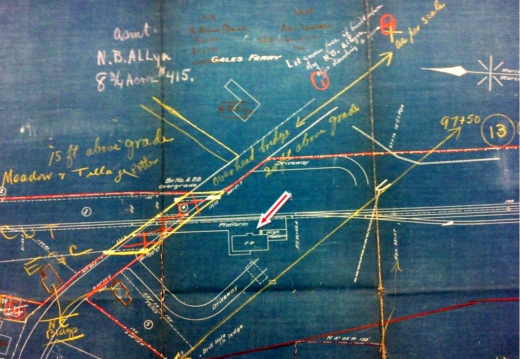
GALES FERRY [NYNH&H, 1899]
This station in the town of Ledyard debuted with the Groton Extension that opened on 6/4/1899. It was said to be in the works in March and also in May of 1899 when it was said that "the Consolidated Railroad will establish a station there with commodious depot to meet all requirements." This location was on the Noyes Allen property, about midway between the Yale crew headquarters and Harvard's base house where the NYNH&H would establish a RED TOP station. Probably opening mid-1899, we find no further mention of GALES FERRY until a would-be robber was shot by the Station Agent Brooks on 11/11/1900, at which time Brooks was said to have worked for the railroad for two years. The intruder, reportedly well-dressed and carrying a gold watch, was later identified as George Miner, a 55-year old resident of Montville who had "spent the greater part of the past quarter century in the Connecticut state prison for different burglaries." In a bizarre turn of events, the station was burglarized a second time just a day later! The station agent's hat and the keys to Harvard's Red Top training quarters, which was owned by the railroad, were taken. Were the two incidents connected? Could the keys have been what Miner was looking for? Were there more sinister plans afoot? Sabotage?? Kidnapping??? We probably will never know but will keep looking! The postcard at upper right was mailed on 11/29/1907. The val map at lower middle shows the station layout in 1915. The image at lower right is dated 3/2/1931. As was often the case, real estate values soared in the area with the coming of the railroad extension that the N&W had wanted to put in for 20 years. The Yale-Harvard boat competitions also contributed to the growth of this beautiful stretch of land along the Thames River. [REFS: NLD/03/20/1899/05; NHER/05/03/1899/05; NHER/11/12/1900/05; HC/11/14/1900/02; F14-16][rev051813; 032322]
This station in the town of Ledyard debuted with the Groton Extension that opened on 6/4/1899. It was said to be in the works in March and also in May of 1899 when it was said that "the Consolidated Railroad will establish a station there with commodious depot to meet all requirements." This location was on the Noyes Allen property, about midway between the Yale crew headquarters and Harvard's base house where the NYNH&H would establish a RED TOP station. Probably opening mid-1899, we find no further mention of GALES FERRY until a would-be robber was shot by the Station Agent Brooks on 11/11/1900, at which time Brooks was said to have worked for the railroad for two years. The intruder, reportedly well-dressed and carrying a gold watch, was later identified as George Miner, a 55-year old resident of Montville who had "spent the greater part of the past quarter century in the Connecticut state prison for different burglaries." In a bizarre turn of events, the station was burglarized a second time just a day later! The station agent's hat and the keys to Harvard's Red Top training quarters, which was owned by the railroad, were taken. Were the two incidents connected? Could the keys have been what Miner was looking for? Were there more sinister plans afoot? Sabotage?? Kidnapping??? We probably will never know but will keep looking! The postcard at upper right was mailed on 11/29/1907. The val map at lower middle shows the station layout in 1915. The image at lower right is dated 3/2/1931. As was often the case, real estate values soared in the area with the coming of the railroad extension that the N&W had wanted to put in for 20 years. The Yale-Harvard boat competitions also contributed to the growth of this beautiful stretch of land along the Thames River. [REFS: NLD/03/20/1899/05; NHER/05/03/1899/05; NHER/11/12/1900/05; HC/11/14/1900/02; F14-16][rev051813; 032322]
GAYLORDS BRIDGE, GAYLORDSVILLE [> MERWINSVILLE]
|
Dave Peters Collection
|

historyofredding.com
|

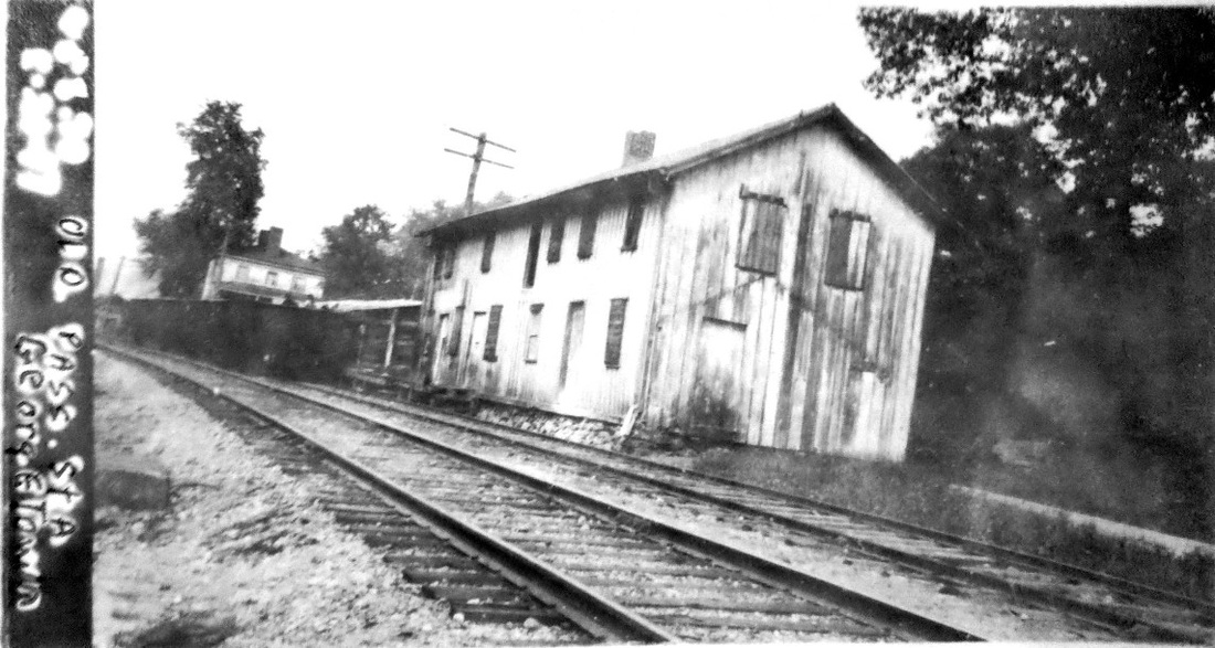
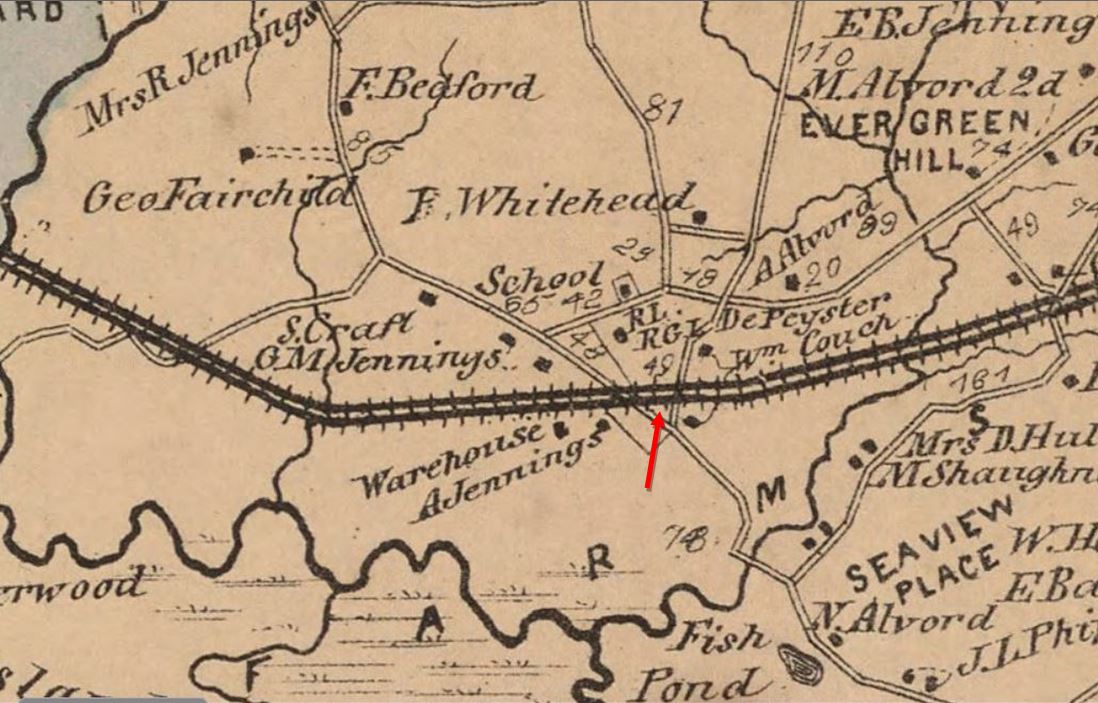
GEORGETOWN1 [D&N, 1852]
This first structure was on the east side of the track, as seen on the 1856FC map at [4], which ran on the east bank of the Norwalk River. According to Brent Colley's informative website on Redding history [click here], the first depot was at our arrow on Old Mill Rd. and actually in Wilton. The two-story station had the railroad depot, post office, and grocery store run by Silliman Godfrey on the first floor. The upper level was used at different times as a meeting hall by various organizations and for manufacturing purposes by local companies, including as a sieve shop by the Gilbert and Bennett Co. At some point in the late 1800s, a freight wing was added on the southern end. In the photo at [1] we can see the depot behind the northbound train. In 1899, this station caught fire from a conflagration that destroyed the adjacent G&B wire mill. About 40 feet of the "long, rambling building of wood" was cut away resulting in separate passenger and freight stations. The val photo at [2] shows this structure still standing and owned by the railroad in 1917. The image [3] is a postcard, with the notation that GEORGETOWN1 was "Vacated on December 30, 1908." [REFS: NHER/08/18/1899/01; WED/08/18/1899/01][rev123017]
This first structure was on the east side of the track, as seen on the 1856FC map at [4], which ran on the east bank of the Norwalk River. According to Brent Colley's informative website on Redding history [click here], the first depot was at our arrow on Old Mill Rd. and actually in Wilton. The two-story station had the railroad depot, post office, and grocery store run by Silliman Godfrey on the first floor. The upper level was used at different times as a meeting hall by various organizations and for manufacturing purposes by local companies, including as a sieve shop by the Gilbert and Bennett Co. At some point in the late 1800s, a freight wing was added on the southern end. In the photo at [1] we can see the depot behind the northbound train. In 1899, this station caught fire from a conflagration that destroyed the adjacent G&B wire mill. About 40 feet of the "long, rambling building of wood" was cut away resulting in separate passenger and freight stations. The val photo at [2] shows this structure still standing and owned by the railroad in 1917. The image [3] is a postcard, with the notation that GEORGETOWN1 was "Vacated on December 30, 1908." [REFS: NHER/08/18/1899/01; WED/08/18/1899/01][rev123017]
|
Dave Peters Collection
|
Mike Grace Collection
|
|

|

|
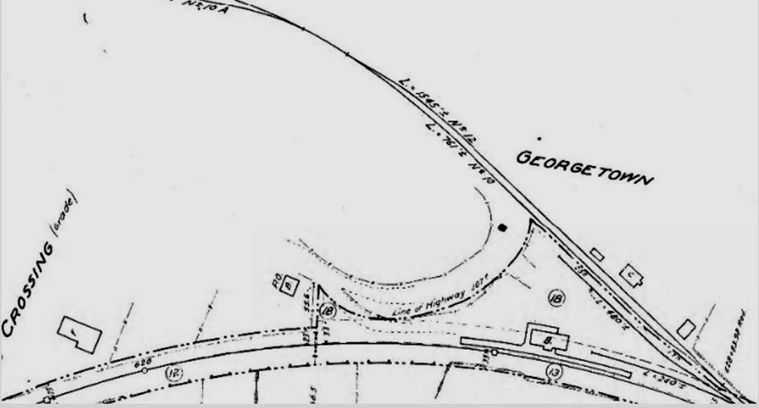
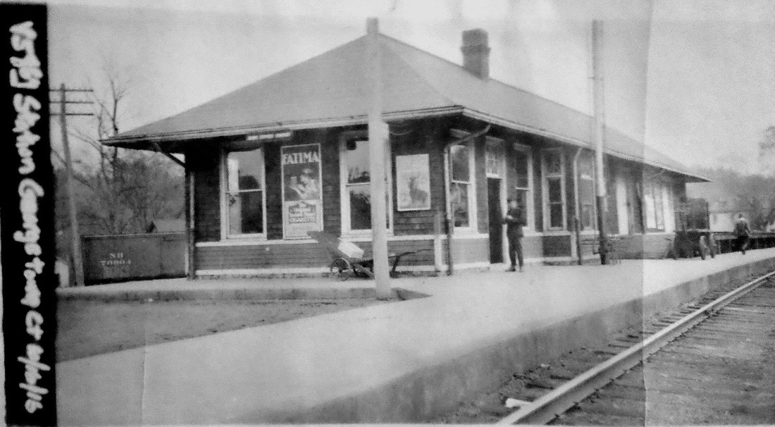
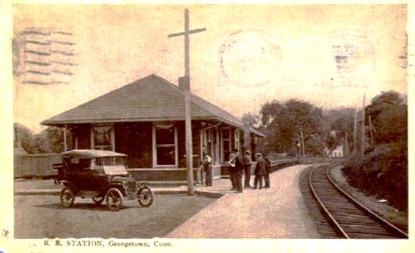
GEORGETOWN2 [NYNH&H, 1908]
The former separate depots, born of fire, were replaced by a new combination station toward the end of the year in 1908. The railroad commissioners reported in December that "a new passenger station has been erected, in a new location, at Georgetown, on the Danbury branch, which has been needed for a long time." The new location was just to the north, over the line in the town of Redding. The NYNH&H annual report issued in June of 1908 said the work was in progress and reported in the next year that the new station had been completed. We have found an article in the Norwalk Hour of 10/15/1908 that says "the new Georgetown station is fast reaching completion and the grounds around it are now being graded. When finished Georgetown will have the finest station between Danbury and South Norwalk..." By 12/18 the Bee reported that "... it is expected that the new depot here is to be opened to the public on Sunday next, December 13...," likely meaning 12/20, which we are going to assume for the error. The val map at [1] shows the arrangement here in 1915; the 'B' that indicates this was a brick station seems to be contradicted by the wood siding seen in the other images. The val photo at [2] is dated 10/16/1916. The postcard at [3] dates to 1919. Shots at [4] and [5] look north, the former showing the siding into the Gilbert and Bennett plant. The photo at [6] is a Thomas Airview from 1955 with the station at dead center. Passenger service was eliminated between 1969 and 1971 by Penn Central due to dwindling ridership; G&B would not close completely until 1989. At [7] is a shot from a recent holiday visit to the Wilton Historical Society, which has a Grand Central Terminal train-departure banner probably from the 1970s; GEORGETOWN has been 'rubbed out.' The passenger station building was presumably gone when Cornwall was writing in the 1980s as he skips right by this stop in his D&N Highlights section. [REFS: NBE/05/29/1908/12; NHO/10/15/1908/00; NBE/12/18/1908/04; CRC56.1908.47; NHAR37.1908.8; NHAR38.1909.7; SL17.4.25; PCTT2/2/1969: yes; PCTT2/1/1971: no; P94,107][rev123017]
The former separate depots, born of fire, were replaced by a new combination station toward the end of the year in 1908. The railroad commissioners reported in December that "a new passenger station has been erected, in a new location, at Georgetown, on the Danbury branch, which has been needed for a long time." The new location was just to the north, over the line in the town of Redding. The NYNH&H annual report issued in June of 1908 said the work was in progress and reported in the next year that the new station had been completed. We have found an article in the Norwalk Hour of 10/15/1908 that says "the new Georgetown station is fast reaching completion and the grounds around it are now being graded. When finished Georgetown will have the finest station between Danbury and South Norwalk..." By 12/18 the Bee reported that "... it is expected that the new depot here is to be opened to the public on Sunday next, December 13...," likely meaning 12/20, which we are going to assume for the error. The val map at [1] shows the arrangement here in 1915; the 'B' that indicates this was a brick station seems to be contradicted by the wood siding seen in the other images. The val photo at [2] is dated 10/16/1916. The postcard at [3] dates to 1919. Shots at [4] and [5] look north, the former showing the siding into the Gilbert and Bennett plant. The photo at [6] is a Thomas Airview from 1955 with the station at dead center. Passenger service was eliminated between 1969 and 1971 by Penn Central due to dwindling ridership; G&B would not close completely until 1989. At [7] is a shot from a recent holiday visit to the Wilton Historical Society, which has a Grand Central Terminal train-departure banner probably from the 1970s; GEORGETOWN has been 'rubbed out.' The passenger station building was presumably gone when Cornwall was writing in the 1980s as he skips right by this stop in his D&N Highlights section. [REFS: NBE/05/29/1908/12; NHO/10/15/1908/00; NBE/12/18/1908/04; CRC56.1908.47; NHAR37.1908.8; NHAR38.1909.7; SL17.4.25; PCTT2/2/1969: yes; PCTT2/1/1971: no; P94,107][rev123017]
GIBBS [> FITCHVILLE JUNCTION]
GIFFORDS [> WEST STREET]
GLEN FOUNDRY [NH&N, 1883]
New flag stop in CANTON established one mile above COLLINSVILLE on the Canal line. [REFS: FVH/07/26/1883/04]
GIFFORDS [> WEST STREET]
GLEN FOUNDRY [NH&N, 1883]
New flag stop in CANTON established one mile above COLLINSVILLE on the Canal line. [REFS: FVH/07/26/1883/04]
Dave Peters Collection
|

|

|
Max Miller Collection
|

Max Miller Collection
|
|
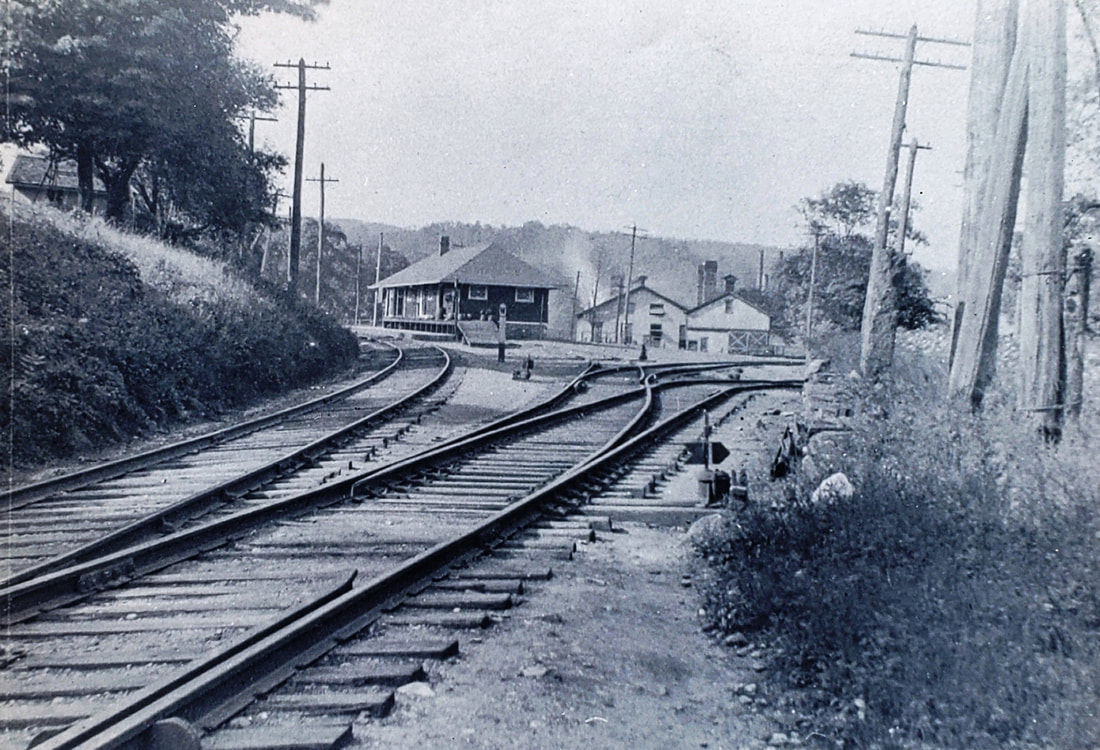
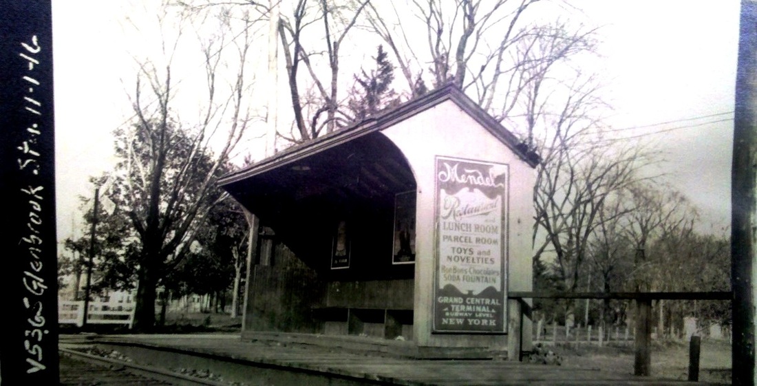
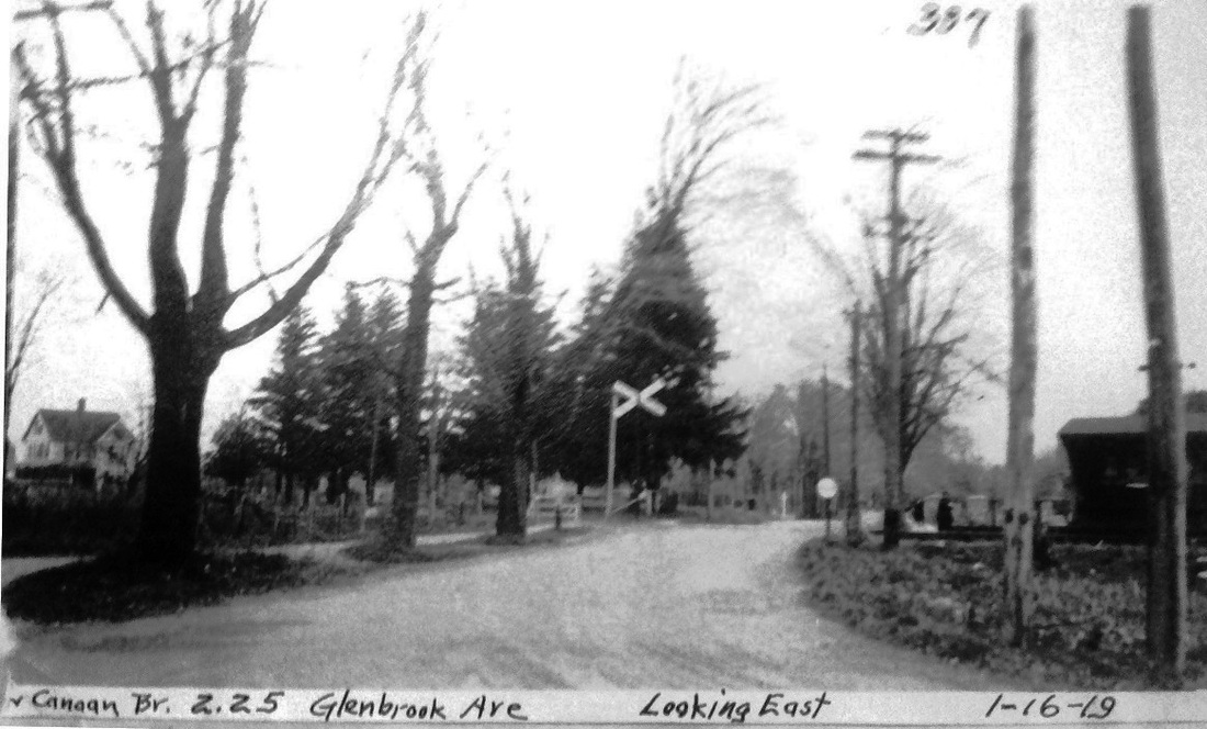
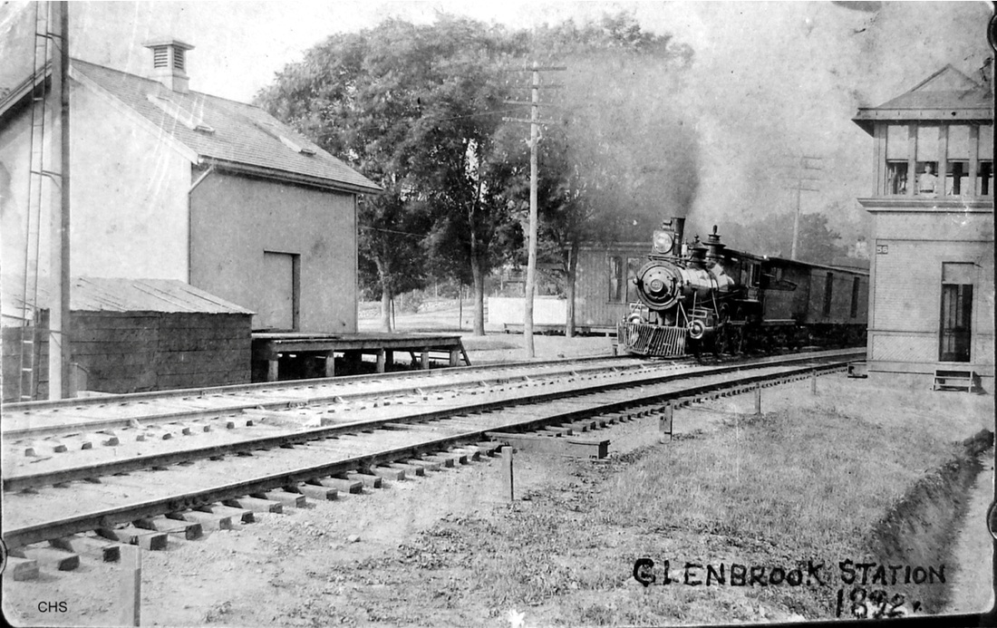
GLENBROOK/N1 [NCRR, 1868?]
We are using the /N for the history of stops at this location on the New Canaan RR, as opposed to the stations on the main line. This stop was in the so-named section of STAMFORD in its southeastern corner bordering DARIEN. This stop is on the first RRM in 1876 along with SPRINGDALE and TALMADGE HILL. The structure seen here, the earliest we have ever come across, may be the first built by the NCRR when it debuted in 1868, or even a later one put up by the NYNH&H after it got control of this 7.5-mile branch in 1883. Coincidentally, a newspaper article of that year mentions a station here. As we speculated about an undated copy of the photo at [1] based on the Mendel's poster ad on the side, the shot dates to 11/1/1916. The Times first reported in 1872 that Jacob Mendel began checking parcels in the first Grand Central Terminal. His lucrative business became a New York City institution until 1920 when his family was outbid by J.P. Carey & Sons for the rented space at GCT. We have highlighted the station on the 1915 val map at [3] where it is shown to be in the southeast quadrant of the crossing at Glenbrook Rd. The tiny oblong shape toward the right end of the platform may be the shed pictured here, though it is not marked 'FP' for frame (wood) passenger depot, as was the custom on val maps. The 1912 NYNH&H real estate map at [2] shows the depot in the southwest quadrant. Assuming both maps are correct, the station was moved between those dates, possibly as part of a track or street realignment. Of the two PUC inspection photos, the eastward view [4] is dated 1/16/1919 and south-looking shot [5] is from 9/11/1924. [REFS: NHER/07/14/1883/04; NYT/02/01/1920/09][rev070215, 120322]
We are using the /N for the history of stops at this location on the New Canaan RR, as opposed to the stations on the main line. This stop was in the so-named section of STAMFORD in its southeastern corner bordering DARIEN. This stop is on the first RRM in 1876 along with SPRINGDALE and TALMADGE HILL. The structure seen here, the earliest we have ever come across, may be the first built by the NCRR when it debuted in 1868, or even a later one put up by the NYNH&H after it got control of this 7.5-mile branch in 1883. Coincidentally, a newspaper article of that year mentions a station here. As we speculated about an undated copy of the photo at [1] based on the Mendel's poster ad on the side, the shot dates to 11/1/1916. The Times first reported in 1872 that Jacob Mendel began checking parcels in the first Grand Central Terminal. His lucrative business became a New York City institution until 1920 when his family was outbid by J.P. Carey & Sons for the rented space at GCT. We have highlighted the station on the 1915 val map at [3] where it is shown to be in the southeast quadrant of the crossing at Glenbrook Rd. The tiny oblong shape toward the right end of the platform may be the shed pictured here, though it is not marked 'FP' for frame (wood) passenger depot, as was the custom on val maps. The 1912 NYNH&H real estate map at [2] shows the depot in the southwest quadrant. Assuming both maps are correct, the station was moved between those dates, possibly as part of a track or street realignment. Of the two PUC inspection photos, the eastward view [4] is dated 1/16/1919 and south-looking shot [5] is from 9/11/1924. [REFS: NHER/07/14/1883/04; NYT/02/01/1920/09][rev070215, 120322]
|

|
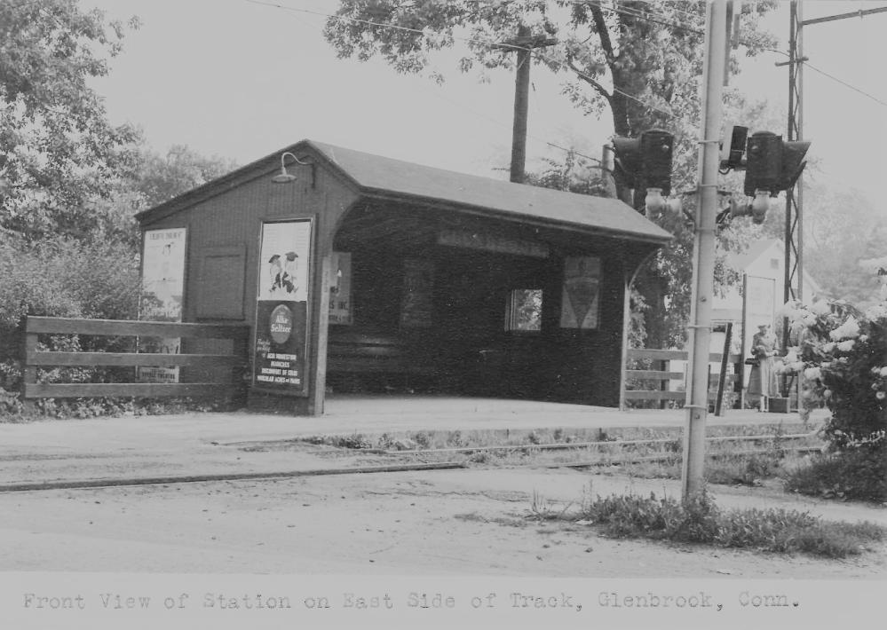
GLENBROOK/N2 [NYNH&H, c1930?]
The photograph on the left has a date of August 24, 1954 stamped on the back and looks to be a Charlie Gunn shot of the period. The one on the right dates to July, 1935 and widens the time frame for this depot, which may be GLENBROOK/N1 expanded rearward and fitted up with more comfortable seating. In any case, it seems different enough to give it its own TCS listing. The addition appears to be made of cement blocks, which would verify what Ed Wadhams said for the demise of this structure in late 1967 or early 1968, when "a rather large truck was backing into the driveway behind the building. It missed the driveway but it didn't the Branch Line Station. Cement blocks went in all directions."(!) Thus ended, it was replaced by GLENBROOK/N3.
The photograph on the left has a date of August 24, 1954 stamped on the back and looks to be a Charlie Gunn shot of the period. The one on the right dates to July, 1935 and widens the time frame for this depot, which may be GLENBROOK/N1 expanded rearward and fitted up with more comfortable seating. In any case, it seems different enough to give it its own TCS listing. The addition appears to be made of cement blocks, which would verify what Ed Wadhams said for the demise of this structure in late 1967 or early 1968, when "a rather large truck was backing into the driveway behind the building. It missed the driveway but it didn't the Branch Line Station. Cement blocks went in all directions."(!) Thus ended, it was replaced by GLENBROOK/N3.
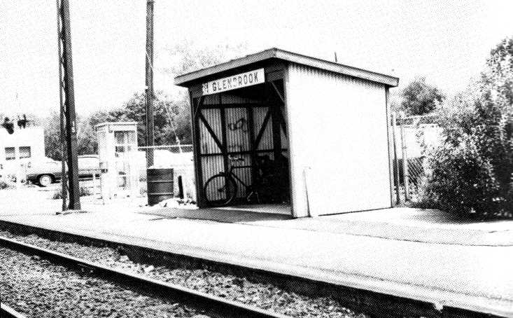
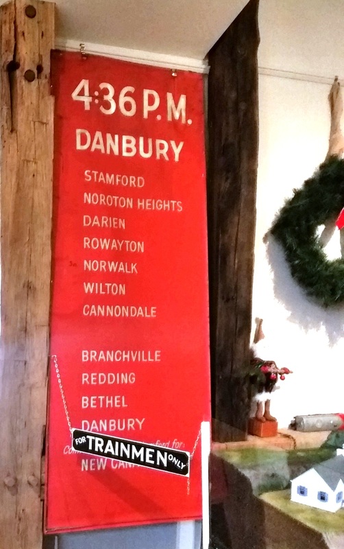
GLENBROOK/N3 [NYNH&H, 1968]
This is obviously a late NHRR structure with the Herbert Matter block-lettered logo. See Rick Abramson's article in the Shoreliner for this photo and more on the branch. Follow-up letters say that this corrugated metal structure was the third station on the branch. It was in service by March, 1968, and it couldn't be missed as it was bright green. [REFS: SL20.2.25; SL21.1.4]
This is obviously a late NHRR structure with the Herbert Matter block-lettered logo. See Rick Abramson's article in the Shoreliner for this photo and more on the branch. Follow-up letters say that this corrugated metal structure was the third station on the branch. It was in service by March, 1968, and it couldn't be missed as it was bright green. [REFS: SL20.2.25; SL21.1.4]
|

|
|
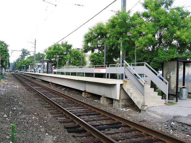
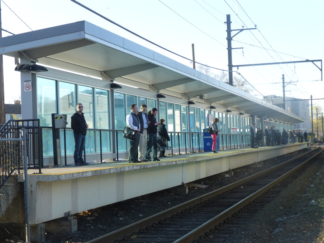
GLENBROOK/N4 [PC, 1973]
Work was going on in September, 1972 and this station was in service a year later, according to a letter from Ed Wadhams in the Shoreliner. A newspaper article in 1974 celebrating ConnDOT's completion of the high-level rail platform and plexi-glass waiting shed at NOROTON HEIGHTS said these facilities were to complement the "new electric commuter cars now in service." The article also reported that, along with most of the stations on the main line, all the stops on the New Canaan branch already had the new platforms. Penn Central was the operator at the time until Conrail took over in 1976. The photos at [2] and [3] show this station after a May, 2014 ConnDOT rebuild. [REFS: HC/05/23/1974/95D; SL21.1.5][rev052215]
Work was going on in September, 1972 and this station was in service a year later, according to a letter from Ed Wadhams in the Shoreliner. A newspaper article in 1974 celebrating ConnDOT's completion of the high-level rail platform and plexi-glass waiting shed at NOROTON HEIGHTS said these facilities were to complement the "new electric commuter cars now in service." The article also reported that, along with most of the stations on the main line, all the stops on the New Canaan branch already had the new platforms. Penn Central was the operator at the time until Conrail took over in 1976. The photos at [2] and [3] show this station after a May, 2014 ConnDOT rebuild. [REFS: HC/05/23/1974/95D; SL21.1.5][rev052215]

|

|
Connecticut Historical Society
|
GLENBROOK/M1 [NYNH&H, 1882; depot, 1885, WB]
We are using the /M to differentiate main line stations from the ones on the New Canaan RR. A February, 1882 Register article says that "a new station, called Glenbrook, at which all accommodation trains will stop, has been established on the New York, New Haven and Hartford railroad between Stamford and Darien." A depot here was built by June of 1882 when the paper said... "The new railroad depot, built at the expense of a few individuals, has proved a great convenience..." Access to the nearby "Brook Farm" was also mentioned. This apparently was an expanse of 60 acres created as part of local landowner C.H. Phillips's real estate development in which he allowed people "... to wander freely about his grounds on which he has spent a fortune for others to enjoy." It sounds like this was yet another example of private funds used to get trains stop at a location, much like our website namesake TYLER CITY. The 1893 map at [4] shows the location of the two GLENBROOK stations, this one being on the westbound side of the two-track main line in the northwest corner of Crescent and Courtland St. grade crossing. The 1892 shot at [1] shows the uniformed station agent standing in front of the depot, a hipped-roof structure with oversized eave brackets, non-matching dormers, and a track-side bay window. Note the decorative, arched lettering over the entrance. The photo at [2] has a date of November, 1892 in the bottom right corner. This station lasted probably until 1894 when the four-tracking was completed here and new depots were built on both sides of the tracks. The photo at [3] shows a westbound train heading toward Stamford and passing this station, the corner of which can be seen to the left of the engine. The freight house is at left also. The SS 56 tower was one of the 'pioneer' wooden signal stations of 1888. The newspaper reported its debut in August of that year. Within the next 20 years or so, the original towers were supplemented, replaced, or modernized and the entire system was renumbered around 1912. The later Glenbrook tower was SS 39, as it appears in Bill Sample's list on the NHRHTA website. Richard Fleischer offers the following commentary on this photo: The signal whose mast is visible at the left was wire-pulled rather than pipe-connected. The carriers for the wire can be seen along the nearest track with the wire passing under both tracks inside a wooden covering to the signal. Notice also the rail braces on the outsides of the rails like the one found a couple of years ago [in Orange on the NH&D: see Track 4B, MP 4.51.2]. It shows their use. Although I can't read the engine number, it looks like one of the Master Mechanic John Henney eight-wheelers. When built these engines had large Ionic cap stacks, but around 1892 those cap stacks were replaced with plain taper stacks." Many thanks, as always, to Richard for his technical expertise and his willingness to share his observations. With his analysis, this photograph becomes a rare and very significant reflection of 1890s interlocking technology on the NYNH&H. [REFS: NHER/02/01/1882/04; SDA/06/16/1882/02; SDA/07/29/1883/03; SDA/08/05/1887/03; NHER/06/03/1885/01: new depots building at Darien, East Norwalk. Correct on the first two, the one here was already up; NHER/05/01/1888/04; SDA/08/24/1888/03;][rev071917, 120322]
We are using the /M to differentiate main line stations from the ones on the New Canaan RR. A February, 1882 Register article says that "a new station, called Glenbrook, at which all accommodation trains will stop, has been established on the New York, New Haven and Hartford railroad between Stamford and Darien." A depot here was built by June of 1882 when the paper said... "The new railroad depot, built at the expense of a few individuals, has proved a great convenience..." Access to the nearby "Brook Farm" was also mentioned. This apparently was an expanse of 60 acres created as part of local landowner C.H. Phillips's real estate development in which he allowed people "... to wander freely about his grounds on which he has spent a fortune for others to enjoy." It sounds like this was yet another example of private funds used to get trains stop at a location, much like our website namesake TYLER CITY. The 1893 map at [4] shows the location of the two GLENBROOK stations, this one being on the westbound side of the two-track main line in the northwest corner of Crescent and Courtland St. grade crossing. The 1892 shot at [1] shows the uniformed station agent standing in front of the depot, a hipped-roof structure with oversized eave brackets, non-matching dormers, and a track-side bay window. Note the decorative, arched lettering over the entrance. The photo at [2] has a date of November, 1892 in the bottom right corner. This station lasted probably until 1894 when the four-tracking was completed here and new depots were built on both sides of the tracks. The photo at [3] shows a westbound train heading toward Stamford and passing this station, the corner of which can be seen to the left of the engine. The freight house is at left also. The SS 56 tower was one of the 'pioneer' wooden signal stations of 1888. The newspaper reported its debut in August of that year. Within the next 20 years or so, the original towers were supplemented, replaced, or modernized and the entire system was renumbered around 1912. The later Glenbrook tower was SS 39, as it appears in Bill Sample's list on the NHRHTA website. Richard Fleischer offers the following commentary on this photo: The signal whose mast is visible at the left was wire-pulled rather than pipe-connected. The carriers for the wire can be seen along the nearest track with the wire passing under both tracks inside a wooden covering to the signal. Notice also the rail braces on the outsides of the rails like the one found a couple of years ago [in Orange on the NH&D: see Track 4B, MP 4.51.2]. It shows their use. Although I can't read the engine number, it looks like one of the Master Mechanic John Henney eight-wheelers. When built these engines had large Ionic cap stacks, but around 1892 those cap stacks were replaced with plain taper stacks." Many thanks, as always, to Richard for his technical expertise and his willingness to share his observations. With his analysis, this photograph becomes a rare and very significant reflection of 1890s interlocking technology on the NYNH&H. [REFS: NHER/02/01/1882/04; SDA/06/16/1882/02; SDA/07/29/1883/03; SDA/08/05/1887/03; NHER/06/03/1885/01: new depots building at Darien, East Norwalk. Correct on the first two, the one here was already up; NHER/05/01/1888/04; SDA/08/24/1888/03;][rev071917, 120322]
Dave Peters Collection
|

|
|

GLENBROOK/M2 [NYNH&H, c1897, WB]
The 1916 val photo at [1] shows a new westbound structure with a completely different profile and roof line. This saltbox depot was most likely built at the time of the four-tracking in 1897 when this style was in vogue. The photos at [2] and [3] look toward New Haven with this station on the left in the latter. The smaller eastbound GLENBROOK/M3 is seen on the right in the wider view at [3]. The NYNH&H real estate map at [4] dates to October, 1907 and shows the two stations along the newly aligned right of way to the south of the old main line, the curve having been reduced with the improvements. Note that the old main was still in use as a siding. [HC/04/06/1911/05][rev122514, 120322]
The 1916 val photo at [1] shows a new westbound structure with a completely different profile and roof line. This saltbox depot was most likely built at the time of the four-tracking in 1897 when this style was in vogue. The photos at [2] and [3] look toward New Haven with this station on the left in the latter. The smaller eastbound GLENBROOK/M3 is seen on the right in the wider view at [3]. The NYNH&H real estate map at [4] dates to October, 1907 and shows the two stations along the newly aligned right of way to the south of the old main line, the curve having been reduced with the improvements. Note that the old main was still in use as a siding. [HC/04/06/1911/05][rev122514, 120322]
Dave Peters Collection
|
|
GLENBROOK/M3 [NYNH&H, c1897, EB]
This was likely built by 1897 on the eastbound side of the main line with the four-tracking and elevation project. The val map at left is dated 11/1/1916. This stop lasted at least until our 2/2/1969 Penn Central timetable and was reportedly curtailed when the high-level platforms were built and M-2 cars went into service in the early 1970s. At that point only two morning and two evening rush hour trains were stopping here. Thereafter, the nearby New Canaan branch station was left to serve this area. [REFS: SL13.4.28][rev100512]
This was likely built by 1897 on the eastbound side of the main line with the four-tracking and elevation project. The val map at left is dated 11/1/1916. This stop lasted at least until our 2/2/1969 Penn Central timetable and was reportedly curtailed when the high-level platforms were built and M-2 cars went into service in the early 1970s. At that point only two morning and two evening rush hour trains were stopping here. Thereafter, the nearby New Canaan branch station was left to serve this area. [REFS: SL13.4.28][rev100512]
|
|
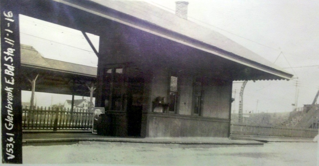
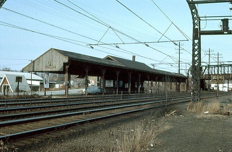
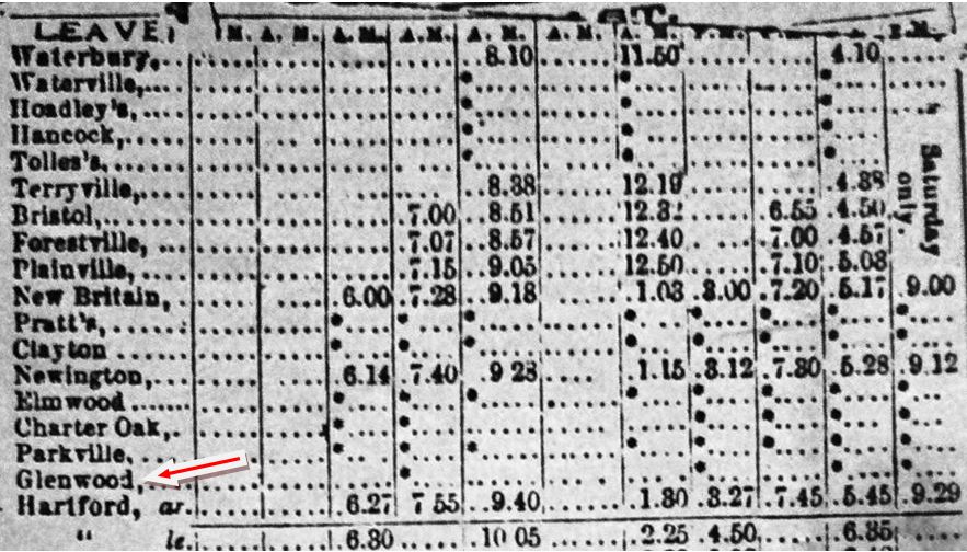
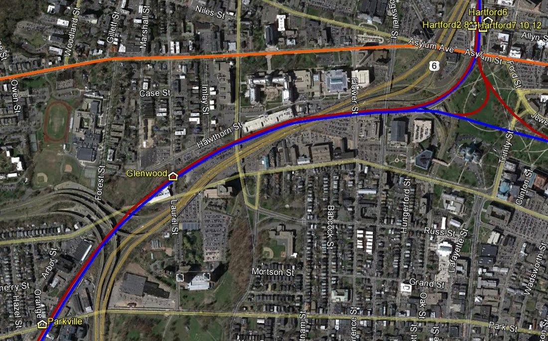
GLENWOOD [NY&NE?, c1887]
The 1887 timetable at left shows this in the city of HARTFORD east of PARKVILLE and the snippet from our Track 11 Google Earth map shows the likely location on Laurel St. The first references we find to this neighborhood are from 1873 when real estate promoters Whiton & Gillette were touting the land for sale in "this busy, beautiful suberb [sic], half a mile west of new capitol." This flag-stop listing is the only that we have seen thus far. [REFS: HDC/07/17/1873/01; HDC/07/22/1874/01][rev031713]
The 1887 timetable at left shows this in the city of HARTFORD east of PARKVILLE and the snippet from our Track 11 Google Earth map shows the likely location on Laurel St. The first references we find to this neighborhood are from 1873 when real estate promoters Whiton & Gillette were touting the land for sale in "this busy, beautiful suberb [sic], half a mile west of new capitol." This flag-stop listing is the only that we have seen thus far. [REFS: HDC/07/17/1873/01; HDC/07/22/1874/01][rev031713]
GOODSPEEDS [> EAST HADDAM]
GOSHEN [> CLARKS CORNER]
GOSHEN [> CLARKS CORNER]
|

National Archives
|
|
|
|
|

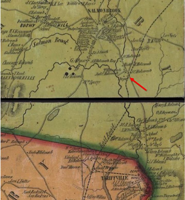
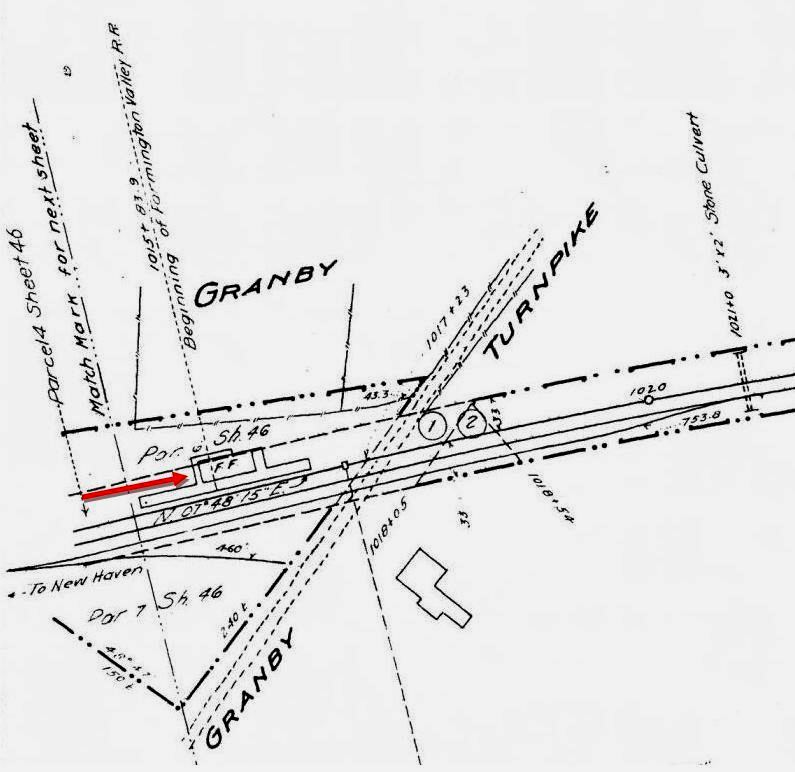
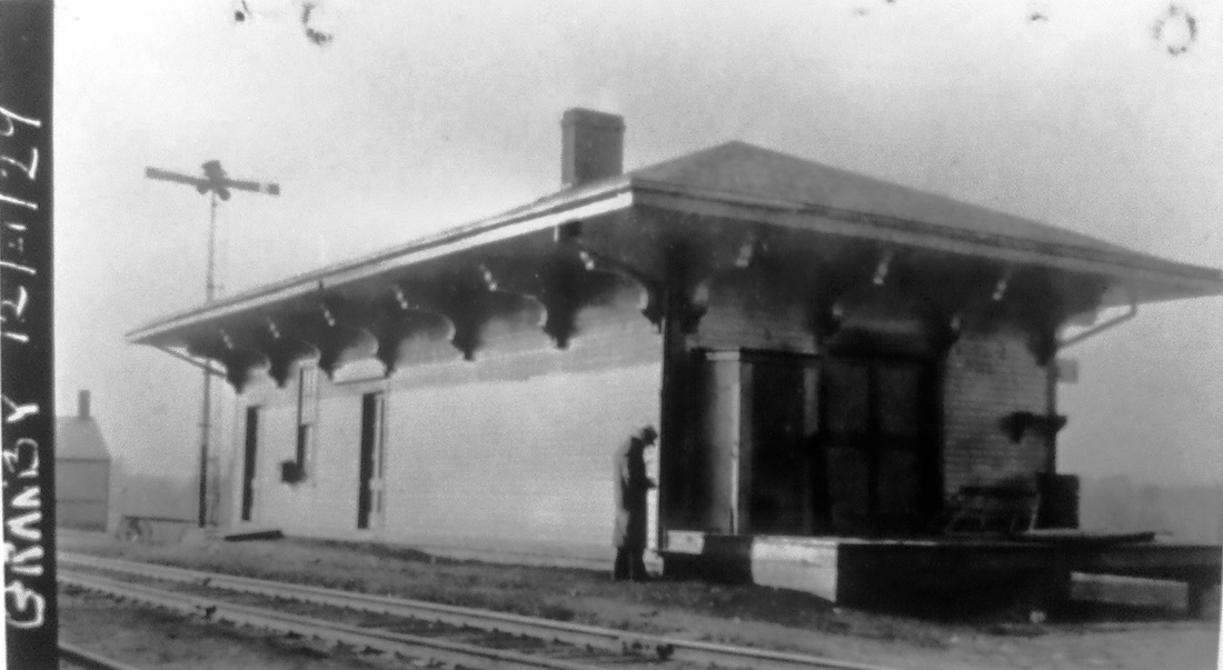
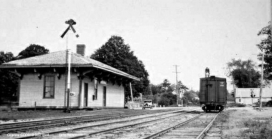
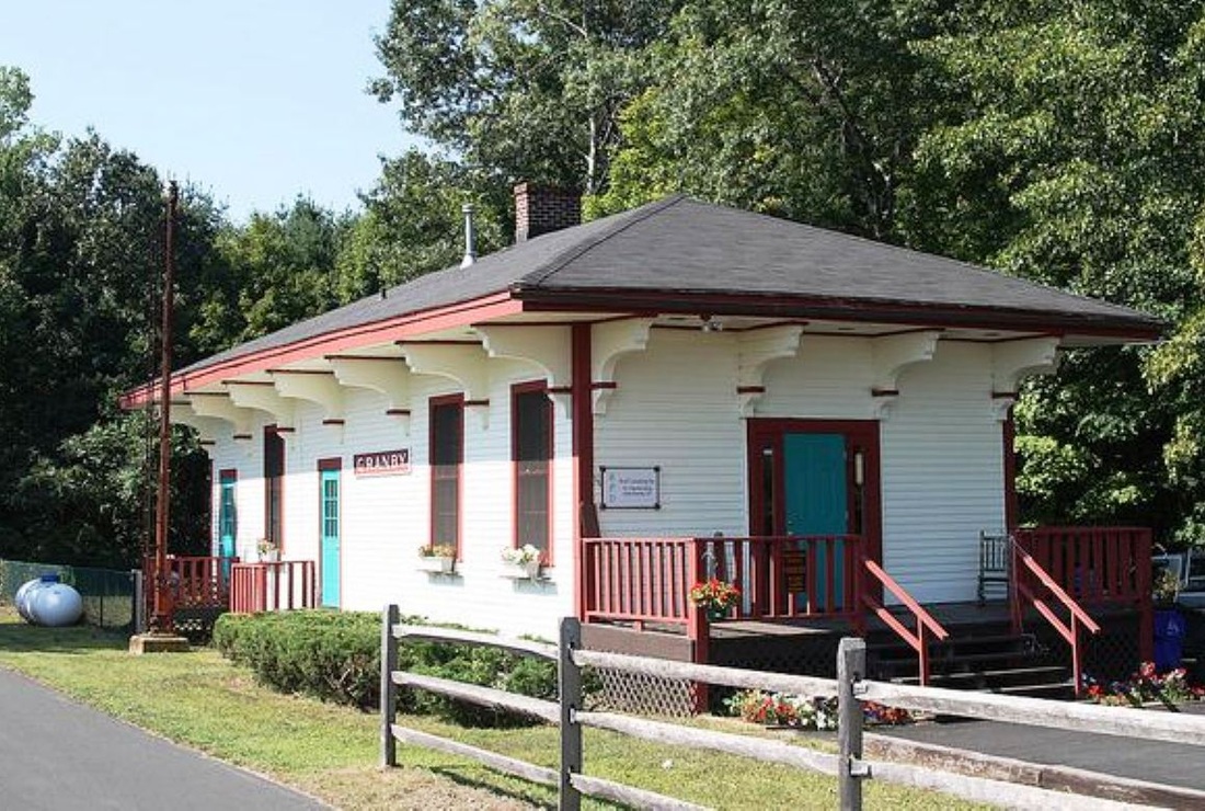
GRANBY [NH&N, 1850; depot, 1854]
Springman and Guinan say that the NH&N reached Hartford Ave. in 1850 and built this station about 1853. The Springfield Republican newspaper tells us on 12/2/1854 that "the Canal railroad is open to Westfield and one passenger train runs over it to New Haven and back daily..." We think, therefore, it is likely that this GRANBY structure debuted in 1854. It is a wooden combination depot similar to AVON, SIMSBURY1 and others built by the NY&NH, lessee of the NH&N from 1848 to 1869. An 1852 newspaper article makes the first specific reference we have seen to this place when it says someone is under contract to furnish 15,000 chestnut railroad ties "... at the Granby station..." but we think this means a staging point rather than a railroad station open for passenger and freight business. Indeed, timetables never show GRANBY as a terminus; TARIFFVILLE is listed as such at least until 1852 and likely until 1854 when Westfield, MA was reached, thereafter leaving the old terminus and the one-mile line from HOSKINS [JUNCTION] truly as a branch. The collusion between the NY&NH and the H&NH to derail efforts to build trackage north of here is well known but Joseph Sheffield, leading proponent of the canal and its successor railroad, got the Farmington Valley R.R. chartered in 1852 to build the remaining 4.67 miles from what was then Granby Tpke., not the shorter or longer distances claimed by those embroiled in the controversy to finish this road. The 1855 map at [1] shows the location of the depot and the val photo at [2] shows a northbound train at the station on 10(?)/2/1916. The val map snippet at [3] shows the starting point of Sheffield's FVRR. The 12/21/1929 val photo at [4] highlights the fact that this depot, like the others on the line, seems to never have had an agent's bay. The Lewis H. Benton shot at [5] catches sidekick/chauffeur Irving N. Drake atop the box car, his sedan in the middle distance. GRANBY still stands, exceptionally well preserved and with signal mast still in place, as seen in the 2013 photo at [6]. The 7/8/1852 newspaper ad at [7] shows commutation rates from New York to Tariffville on the jointly run NY&NH/NH&N line. [REFS: HDC/01/09/1850/02: 100 rods/eight miles; SR/02/14/1852/02; HDC/07/08/1852/04; SR/04/06/1854/02: seven miles; D113; E145, 146; R56][rev011515]
Springman and Guinan say that the NH&N reached Hartford Ave. in 1850 and built this station about 1853. The Springfield Republican newspaper tells us on 12/2/1854 that "the Canal railroad is open to Westfield and one passenger train runs over it to New Haven and back daily..." We think, therefore, it is likely that this GRANBY structure debuted in 1854. It is a wooden combination depot similar to AVON, SIMSBURY1 and others built by the NY&NH, lessee of the NH&N from 1848 to 1869. An 1852 newspaper article makes the first specific reference we have seen to this place when it says someone is under contract to furnish 15,000 chestnut railroad ties "... at the Granby station..." but we think this means a staging point rather than a railroad station open for passenger and freight business. Indeed, timetables never show GRANBY as a terminus; TARIFFVILLE is listed as such at least until 1852 and likely until 1854 when Westfield, MA was reached, thereafter leaving the old terminus and the one-mile line from HOSKINS [JUNCTION] truly as a branch. The collusion between the NY&NH and the H&NH to derail efforts to build trackage north of here is well known but Joseph Sheffield, leading proponent of the canal and its successor railroad, got the Farmington Valley R.R. chartered in 1852 to build the remaining 4.67 miles from what was then Granby Tpke., not the shorter or longer distances claimed by those embroiled in the controversy to finish this road. The 1855 map at [1] shows the location of the depot and the val photo at [2] shows a northbound train at the station on 10(?)/2/1916. The val map snippet at [3] shows the starting point of Sheffield's FVRR. The 12/21/1929 val photo at [4] highlights the fact that this depot, like the others on the line, seems to never have had an agent's bay. The Lewis H. Benton shot at [5] catches sidekick/chauffeur Irving N. Drake atop the box car, his sedan in the middle distance. GRANBY still stands, exceptionally well preserved and with signal mast still in place, as seen in the 2013 photo at [6]. The 7/8/1852 newspaper ad at [7] shows commutation rates from New York to Tariffville on the jointly run NY&NH/NH&N line. [REFS: HDC/01/09/1850/02: 100 rods/eight miles; SR/02/14/1852/02; HDC/07/08/1852/04; SR/04/06/1854/02: seven miles; D113; E145, 146; R56][rev011515]

|

National Archives
|
Max Miller Collection
|

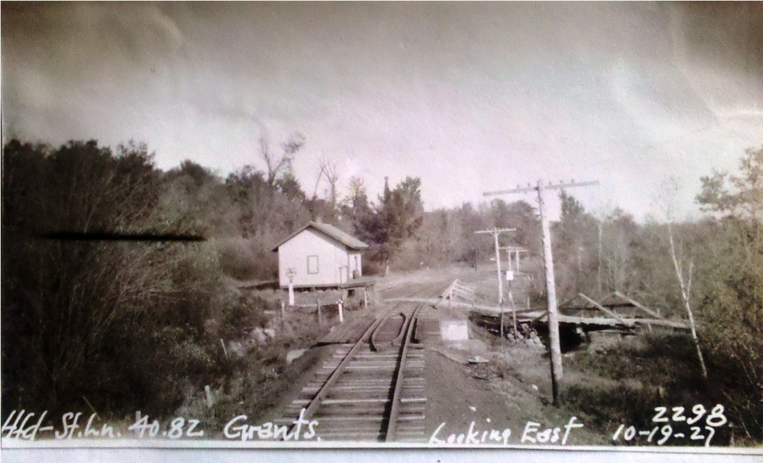
GRANTS [CW, 1871, opens as SOUTH NORFOLK]
This stop was in the town of NORFOLK. On an initial list in the Courant late in 1871, it is first seen as SOUTH NORFOLK, 41.25 miles from Hartford. This mileage point corresponds to GRANTS on CW ETT#2 (1/1/1872). As reported by TCS contributor Craig Michaelsen the Connecticut Western News said on 11/29/1872: Another New Depot. Last Monday Mr. George Bundy commenced the erection of a new depot at what is known as Grant's Station, two or three miles east of Norfolk on the Conn. Western road. It is to be in style very much like the depot at the Twin Lakes station, [see TWIN LAKES1] but in size a little larger, measuring 20x32. Bundy of course, was a respected contractor who built several depots for the CW, including CANAAN2, the extant Union Station. Dubbing this station as GRANTS was for the well-known local family of that name and occasioned an interesting 1872 political commentary in the Winsted Herald, the excoriating text of which we can't resist giving here in full: "Grantville. Can nepotism go further? President Grant, not content with creating a post office at the milk station near the Harry Grant place in Norfolk, and naming it "Grantville," and appointing his 40-leventh cousin, Moses F. Grant, to be postmaster, has been emboldened to proceed to further high-handed measures since his reelection and has instructed his subservient tools -- the Conn. Western directors -- to build a new depot, 20 by 32, at that remote and obscure point, under the preposterous pretense that there is, present and prospective, business enough there to require it. Where are our liberties?" Obviously, the writer did not care for either Pres. Grant, Moses Grant who was a well-known local figure, the CW directors, or all of the above! The dimensions of the station do, however, measure up to the one we have photos of. The 1880 NY&NE appraisal of CW properties said the small station here was in good condition and worth $350, making it seem somewhat larger than COLEBROOK1. Notes from Editor Ted Vaill's Here N' There column in the Winsted Evening Citizen, say that this station may possibly have been called GRANTVILLE in its early days and at one time was an agency station with an operator on all three shifts. An 1894 Connecticut Western News note, in fact, says that the PR&NE was closing PINE MEADOW and GRANTS stations. Timetables still show the stop so the move must have been the elimination of the agency post, so that "Operator Roberts and Lyons are thrown out of employment." The image at [1] is probably from the 1890s and the val photo at [2] is likely from the 1920s. The eastward-looking PUC inspection shot at [3] is dated 10/19/1927. The photo at [4] is dated 1928; the pair motoring between is seen in other CNE station shots of the period. [REFS: HDC/12/21/1871/02; WH/11/22/1872/03; CWN/11/29/1872/00; DC/06/10/1873/02; CWN/02/15/1894/03; HC/07/27/1905/13; D32; N3.54][rev070215, 120918]
This stop was in the town of NORFOLK. On an initial list in the Courant late in 1871, it is first seen as SOUTH NORFOLK, 41.25 miles from Hartford. This mileage point corresponds to GRANTS on CW ETT#2 (1/1/1872). As reported by TCS contributor Craig Michaelsen the Connecticut Western News said on 11/29/1872: Another New Depot. Last Monday Mr. George Bundy commenced the erection of a new depot at what is known as Grant's Station, two or three miles east of Norfolk on the Conn. Western road. It is to be in style very much like the depot at the Twin Lakes station, [see TWIN LAKES1] but in size a little larger, measuring 20x32. Bundy of course, was a respected contractor who built several depots for the CW, including CANAAN2, the extant Union Station. Dubbing this station as GRANTS was for the well-known local family of that name and occasioned an interesting 1872 political commentary in the Winsted Herald, the excoriating text of which we can't resist giving here in full: "Grantville. Can nepotism go further? President Grant, not content with creating a post office at the milk station near the Harry Grant place in Norfolk, and naming it "Grantville," and appointing his 40-leventh cousin, Moses F. Grant, to be postmaster, has been emboldened to proceed to further high-handed measures since his reelection and has instructed his subservient tools -- the Conn. Western directors -- to build a new depot, 20 by 32, at that remote and obscure point, under the preposterous pretense that there is, present and prospective, business enough there to require it. Where are our liberties?" Obviously, the writer did not care for either Pres. Grant, Moses Grant who was a well-known local figure, the CW directors, or all of the above! The dimensions of the station do, however, measure up to the one we have photos of. The 1880 NY&NE appraisal of CW properties said the small station here was in good condition and worth $350, making it seem somewhat larger than COLEBROOK1. Notes from Editor Ted Vaill's Here N' There column in the Winsted Evening Citizen, say that this station may possibly have been called GRANTVILLE in its early days and at one time was an agency station with an operator on all three shifts. An 1894 Connecticut Western News note, in fact, says that the PR&NE was closing PINE MEADOW and GRANTS stations. Timetables still show the stop so the move must have been the elimination of the agency post, so that "Operator Roberts and Lyons are thrown out of employment." The image at [1] is probably from the 1890s and the val photo at [2] is likely from the 1920s. The eastward-looking PUC inspection shot at [3] is dated 10/19/1927. The photo at [4] is dated 1928; the pair motoring between is seen in other CNE station shots of the period. [REFS: HDC/12/21/1871/02; WH/11/22/1872/03; CWN/11/29/1872/00; DC/06/10/1873/02; CWN/02/15/1894/03; HC/07/27/1905/13; D32; N3.54][rev070215, 120918]
Ramsdell Transportation Collection
|
|
National Archives
|
|

|
|
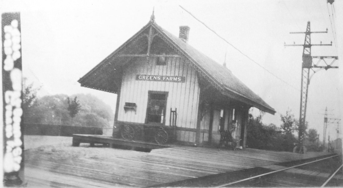
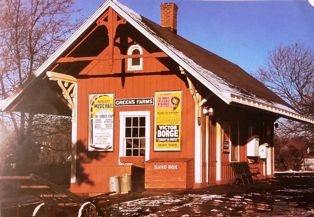
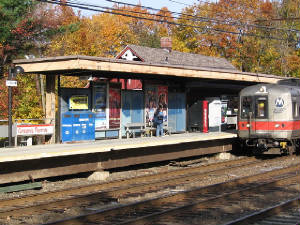
GREENS FARMS1 [NYNH&H, 1869, EB>WB]
In his historical monograph, George Penfield Jennings says that locals in this part of Westport did without a railroad station for 20 years and that "farmers continued to go to Southport or Westport to get their mail, to trade and to replenish their demijohns with gin" and it was not until about 1870 that the farmers "clubbed together and graded for a Greens Farms station, located south of the tracks between the Turkey Hill Road and the Shore Road bridges on the property of the old green." While locals did the prep work, the railroad built the depot. The Courant gives us a 12/1/1868 date for the ground-breaking and the "new depot" wording, along with the fact that the stop does not appear on any early timetables, seems to corroborate the Jennings time frame for creation. A December, 1869 Times article tells us that "at Greens Farms a new and comfortable depot has been erected" within the last year. An 1872 newspaper list of commutation rates marks the first print appearance we have come across, the next being on an 1883 timetable. Jennings says that this was a manned flag stop until 4/7/1875, when George E. Crossman became agent at a time when six daily trains were stopping each way. Crossman subsequently became the first postmaster, a concurrent appointment frequently seen then, and two dozen "pigeon-hole" letter-boxes were made by a local carpenter and installed in the ticket office. A Bee article tells us in 1891 that " ... the Green's Farm station has been moved to the Charles Meeker place to serve as the west-bound station" and Jennings notes that "the building actually 'rode on the cars,' because it was transported on flat cars from the old site to the new..." The image at [1] is an eastward looking view of the depot after the Blizzard of 1888, in its original location with the Shore Rd. bridge in the background. Our red arrow on the 1867 Beers map at [2] does not indicate a depot because it would not be built for another two years. We can't read the date on the val photo at [3] but it is likely 1917. The poster on the image at [4] says Victor Borge's Comedy in Music show is in its third year at the Golden Theatre, making it 1956. The shot at [5] is Conrail, 1982 and [6] is Metro North in the 1970s. This station still serves passengers today in 2018. [REFS: 1848-1883TTs; HDC/12/08/1868/04; CCO/10/09/1869/04; NYT/12/10/ 1869 /02; CR/06/08/1872/03; GHD1879; NHER/04/01/1880/01; NBE/10/24/1890/05; NBE/10/16/1891/06; NHER /03/11/1892/04; HC/08/09/1893/04: burgled; Jennings, Greens Farms, Connecticut: The Old West Parish of Fairfield, 1933, p82+; R56][rev012418]
In his historical monograph, George Penfield Jennings says that locals in this part of Westport did without a railroad station for 20 years and that "farmers continued to go to Southport or Westport to get their mail, to trade and to replenish their demijohns with gin" and it was not until about 1870 that the farmers "clubbed together and graded for a Greens Farms station, located south of the tracks between the Turkey Hill Road and the Shore Road bridges on the property of the old green." While locals did the prep work, the railroad built the depot. The Courant gives us a 12/1/1868 date for the ground-breaking and the "new depot" wording, along with the fact that the stop does not appear on any early timetables, seems to corroborate the Jennings time frame for creation. A December, 1869 Times article tells us that "at Greens Farms a new and comfortable depot has been erected" within the last year. An 1872 newspaper list of commutation rates marks the first print appearance we have come across, the next being on an 1883 timetable. Jennings says that this was a manned flag stop until 4/7/1875, when George E. Crossman became agent at a time when six daily trains were stopping each way. Crossman subsequently became the first postmaster, a concurrent appointment frequently seen then, and two dozen "pigeon-hole" letter-boxes were made by a local carpenter and installed in the ticket office. A Bee article tells us in 1891 that " ... the Green's Farm station has been moved to the Charles Meeker place to serve as the west-bound station" and Jennings notes that "the building actually 'rode on the cars,' because it was transported on flat cars from the old site to the new..." The image at [1] is an eastward looking view of the depot after the Blizzard of 1888, in its original location with the Shore Rd. bridge in the background. Our red arrow on the 1867 Beers map at [2] does not indicate a depot because it would not be built for another two years. We can't read the date on the val photo at [3] but it is likely 1917. The poster on the image at [4] says Victor Borge's Comedy in Music show is in its third year at the Golden Theatre, making it 1956. The shot at [5] is Conrail, 1982 and [6] is Metro North in the 1970s. This station still serves passengers today in 2018. [REFS: 1848-1883TTs; HDC/12/08/1868/04; CCO/10/09/1869/04; NYT/12/10/ 1869 /02; CR/06/08/1872/03; GHD1879; NHER/04/01/1880/01; NBE/10/24/1890/05; NBE/10/16/1891/06; NHER /03/11/1892/04; HC/08/09/1893/04: burgled; Jennings, Greens Farms, Connecticut: The Old West Parish of Fairfield, 1933, p82+; R56][rev012418]
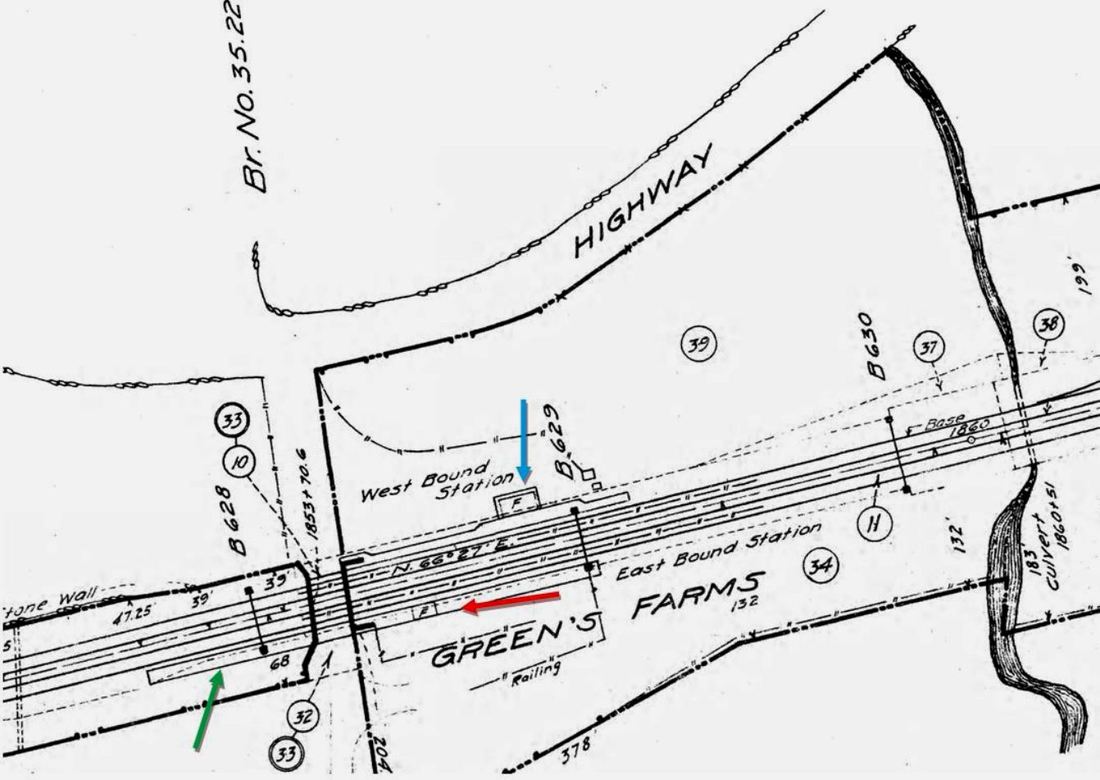
GREENS FARMS2 [NYNH&H, 1891, EB]
An especially revealing article in the Stamford Advocate informs of the progress of the four-tracking in October, 1891 and that it was complete through here. It says further that, after GREENS FARMS1 was moved to the westbound side, "... a small dwelling has been bought on the east side by the company and remodelled (sic) for a depot. It is fitted up with a stove and other conveniences and will be used till spring." Where this was located is not exactly known but the article goes on to state that Farms folk from whom the old station was taken were not happy with the location of the new one. A few months later on 3/11/1892 the Register reported that " ... the old station east of the Consolidated tracks at Green's Farms" burned yesterday, sparks from a passing locomotive thought to have caused the $2,000 loss. Other newspapers candidly said that rumors blamed "parties dissatisfied with the new location...(!)" The coverage in the Bee is the best: "The Greens Farm station burned to the ground at about 5 a m Thursday [3/10], destroying the entire contents of the depot, mail matter, etc. M.M. Crossman's [George's son and his successor as agent] loss was about $50. The platform is being laid opposite the west bound station [GREENS FARMS1] and a new station will be built. The new post office has been placed in the westbound station." We thought originally that "old station" meant GREENS FARMS1 had burned but we now know that it had already been moved to the westbound side, seen at the blue arrow on the 1915 val map snippet. The green arrow shows its previous location, with platform still extending to that point. The Advocate article goes on to say that "... the people at the Farm were indignant when they saw the structure loaded on two flat cars and on its way afar off, and they came down to the [old] spot like men who had been deprived of all..." Unless we are mistaken this move was a mere hundred feet or so east, albeit on the other side of the tracks. Even if the "afar off" is tongue-in-cheek, the outrage and indignation may have been real enough at this disturbance of the established order. Was the discontent so great as to provoke arson? We probably will never know. Needless to say, we have no photo of this short-lived and ill-starred GREENS FARM2. [REFS: HC/03/11/1892/06; NHJC/03/11/1892/05; NHER/03/11/1892/04; WED/03/11/1892/01][rev012418]
An especially revealing article in the Stamford Advocate informs of the progress of the four-tracking in October, 1891 and that it was complete through here. It says further that, after GREENS FARMS1 was moved to the westbound side, "... a small dwelling has been bought on the east side by the company and remodelled (sic) for a depot. It is fitted up with a stove and other conveniences and will be used till spring." Where this was located is not exactly known but the article goes on to state that Farms folk from whom the old station was taken were not happy with the location of the new one. A few months later on 3/11/1892 the Register reported that " ... the old station east of the Consolidated tracks at Green's Farms" burned yesterday, sparks from a passing locomotive thought to have caused the $2,000 loss. Other newspapers candidly said that rumors blamed "parties dissatisfied with the new location...(!)" The coverage in the Bee is the best: "The Greens Farm station burned to the ground at about 5 a m Thursday [3/10], destroying the entire contents of the depot, mail matter, etc. M.M. Crossman's [George's son and his successor as agent] loss was about $50. The platform is being laid opposite the west bound station [GREENS FARMS1] and a new station will be built. The new post office has been placed in the westbound station." We thought originally that "old station" meant GREENS FARMS1 had burned but we now know that it had already been moved to the westbound side, seen at the blue arrow on the 1915 val map snippet. The green arrow shows its previous location, with platform still extending to that point. The Advocate article goes on to say that "... the people at the Farm were indignant when they saw the structure loaded on two flat cars and on its way afar off, and they came down to the [old] spot like men who had been deprived of all..." Unless we are mistaken this move was a mere hundred feet or so east, albeit on the other side of the tracks. Even if the "afar off" is tongue-in-cheek, the outrage and indignation may have been real enough at this disturbance of the established order. Was the discontent so great as to provoke arson? We probably will never know. Needless to say, we have no photo of this short-lived and ill-starred GREENS FARM2. [REFS: HC/03/11/1892/06; NHJC/03/11/1892/05; NHER/03/11/1892/04; WED/03/11/1892/01][rev012418]
GREENS FARMS3 [NYNH&H, 1891?, EB]
This was the small structure to replace GREENS FARMS2, likely put up on the eastbound side with the 1891 four-tracking. We have no actual build or removal date. It is seen on the val map in the previous entry at the red arrow. [rev012418]
This was the small structure to replace GREENS FARMS2, likely put up on the eastbound side with the 1891 four-tracking. We have no actual build or removal date. It is seen on the val map in the previous entry at the red arrow. [rev012418]
GREENS FARMS4 [MN, c2000?, EB]
This small shelter serves the eastbound Metro North passenger today.
This small shelter serves the eastbound Metro North passenger today.
|

|
|

|
|

|
 Robert Ladd Collection
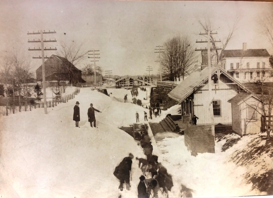
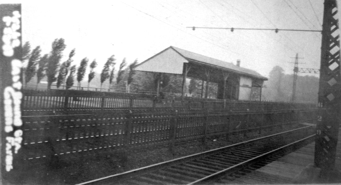
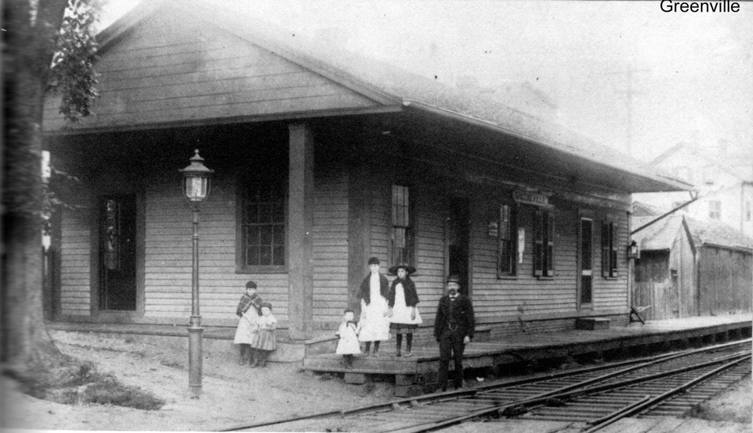
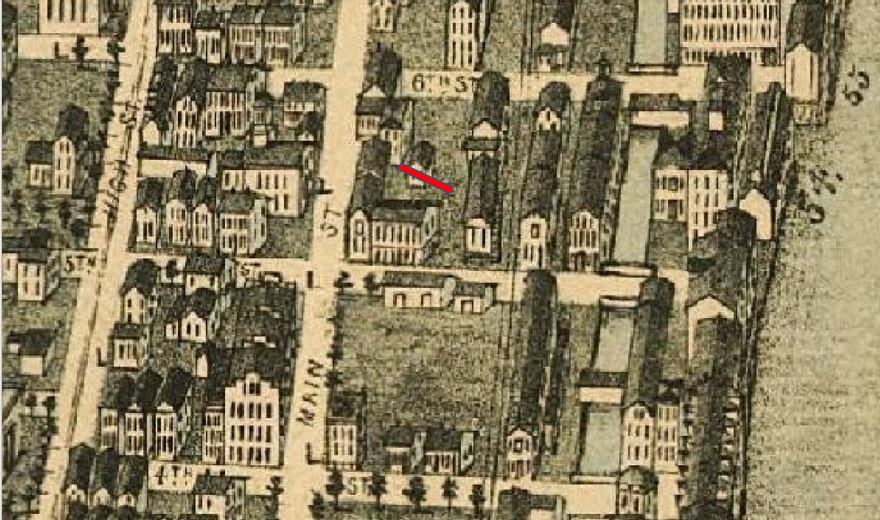
GREENVILLE [N&W, 1840]
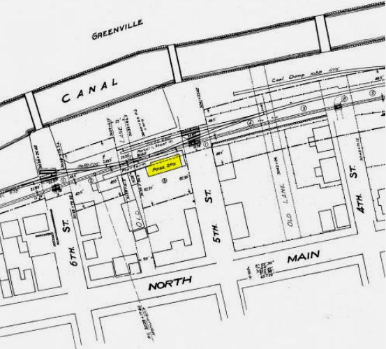
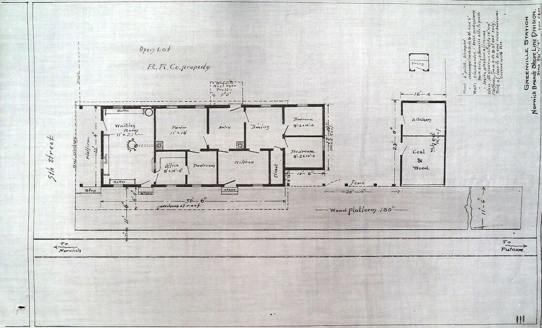
Also spelled GREENEVILLE as discernable on the signboard at [1], this was an original N&W stop upon its 1840 opening; the first train ran on leap year Saturday, February 29. The location in the town of Norwich is seen on the 1854NL map at [2]. Being a mere two miles from NORWICH, this was said not to be a 'popular' stop for locomotive crews who had just gotten up a head of steam from the Rose City. Our red arrow on another of O.H. Bailey's priceless bird's-eye views at [3] presents the depot in 1876. Newspaper articles tell us the birth of the N&W took place right here in Greenville. Ground was broken on 11/18/1835. One account says simply that "... Governor Edwards of New Haven was present and made the address. John Breed wheeled away the first shovelful of earth dug up..." but others tell of a huge ceremony to which Daniel Webster was invited but could not attend. The 11/22/1835 Connecticut Courant reprinted the eyewitness report from the New York Gazette, highlights of which we give here. Governor Edwards was, in fact, there as well as James Brewster, president of the Hartford & New Haven RR and many other notables. Revolutionary War veterans, Norwich and New London government officials and several hundred school children paraded up from the Franklin Hotel "... to the place selected for the commencement of the rail road... a large plain situated near the large manufactories established in this flourishing town, at the southern extremity of which a tent was erected about 100 feet in length and 30 feet in dept, covered with canvass and with seats elevated one above the other, all of which were filled with genteely dressed females... and the whole procession was closed by an immense car, drawn by six horses, on which was displayed samples of the numerous manufactures of that neighborhood, which were intended as examples of the different articles that would hereafter be transported on the railroad... ingrain carpeting, and rugs, domestic goods, bound books, earthen, tin, wooden and hardware, carriages, boats, cordage, ship blocks, saddles, trunks, shoes, cutlery, weaver's reeds, brooms, stoves, harness leather, scythes, axes, glass beads, &c. &c." After remarks by N&W President William C. Gilman, invocations by clergy and other speeches, the governor broke the ground and the parade marched back to Norwich just like it had come. Stadium seating in 1835! It looks like you had to be there to grasp the splendor of the occasion and what it meant to those people. As to the GREENVILLE depot itself, no actual build date has been found but likely it was in 1839 or 1840. Information on an undated newspaper photo even claims "about 1833" but goes on to say more credibly that the U.S. Finishing Co., the textile producer that stood right across the street to the east, leased the property in December, 1921 and purchased it in 1941. The depot is seen as their employment office at [4] in a Lewis H. Benton shot from June, 1929. Note that he labels it "Old NY&NE Station, likely indicating its non-railroad use by then. The 6/30/1915 valuation map at [5] shows it in that year. Judging by the automobiles, it is seen with faded lettering in the late 1930s or early 1940s. The structure was razed in 1944. At [7] is a pretty amazing 3/8/1907 floor plan which Robert Ladd shared from his extensive Norwich collection. It shows an unusually residential layout, with kitchen, bedrooms and parlor. We have never seen such anywhere else! The last station agent to live and work here was Charlie Williams who may well be seen with his family at [1]. He died in 1923 after 43 years of service to the railroad, 38 as stationmaster here. Passenger service had ceased at this stop altogether by 1925. [REFS: COB/11/09/1835/04; CC/11/22/1835/02; CCE/03/04/1840/02; CR/12/11/1875/01; HC/11/25/1923/8Z; Form201TT 5/24/1925: no; Q14-16,84i][rev011314,092522]
Also spelled GREENEVILLE as discernable on the signboard at [1], this was an original N&W stop upon its 1840 opening; the first train ran on leap year Saturday, February 29. The location in the town of Norwich is seen on the 1854NL map at [2]. Being a mere two miles from NORWICH, this was said not to be a 'popular' stop for locomotive crews who had just gotten up a head of steam from the Rose City. Our red arrow on another of O.H. Bailey's priceless bird's-eye views at [3] presents the depot in 1876. Newspaper articles tell us the birth of the N&W took place right here in Greenville. Ground was broken on 11/18/1835. One account says simply that "... Governor Edwards of New Haven was present and made the address. John Breed wheeled away the first shovelful of earth dug up..." but others tell of a huge ceremony to which Daniel Webster was invited but could not attend. The 11/22/1835 Connecticut Courant reprinted the eyewitness report from the New York Gazette, highlights of which we give here. Governor Edwards was, in fact, there as well as James Brewster, president of the Hartford & New Haven RR and many other notables. Revolutionary War veterans, Norwich and New London government officials and several hundred school children paraded up from the Franklin Hotel "... to the place selected for the commencement of the rail road... a large plain situated near the large manufactories established in this flourishing town, at the southern extremity of which a tent was erected about 100 feet in length and 30 feet in dept, covered with canvass and with seats elevated one above the other, all of which were filled with genteely dressed females... and the whole procession was closed by an immense car, drawn by six horses, on which was displayed samples of the numerous manufactures of that neighborhood, which were intended as examples of the different articles that would hereafter be transported on the railroad... ingrain carpeting, and rugs, domestic goods, bound books, earthen, tin, wooden and hardware, carriages, boats, cordage, ship blocks, saddles, trunks, shoes, cutlery, weaver's reeds, brooms, stoves, harness leather, scythes, axes, glass beads, &c. &c." After remarks by N&W President William C. Gilman, invocations by clergy and other speeches, the governor broke the ground and the parade marched back to Norwich just like it had come. Stadium seating in 1835! It looks like you had to be there to grasp the splendor of the occasion and what it meant to those people. As to the GREENVILLE depot itself, no actual build date has been found but likely it was in 1839 or 1840. Information on an undated newspaper photo even claims "about 1833" but goes on to say more credibly that the U.S. Finishing Co., the textile producer that stood right across the street to the east, leased the property in December, 1921 and purchased it in 1941. The depot is seen as their employment office at [4] in a Lewis H. Benton shot from June, 1929. Note that he labels it "Old NY&NE Station, likely indicating its non-railroad use by then. The 6/30/1915 valuation map at [5] shows it in that year. Judging by the automobiles, it is seen with faded lettering in the late 1930s or early 1940s. The structure was razed in 1944. At [7] is a pretty amazing 3/8/1907 floor plan which Robert Ladd shared from his extensive Norwich collection. It shows an unusually residential layout, with kitchen, bedrooms and parlor. We have never seen such anywhere else! The last station agent to live and work here was Charlie Williams who may well be seen with his family at [1]. He died in 1923 after 43 years of service to the railroad, 38 as stationmaster here. Passenger service had ceased at this stop altogether by 1925. [REFS: COB/11/09/1835/04; CC/11/22/1835/02; CCE/03/04/1840/02; CR/12/11/1875/01; HC/11/25/1923/8Z; Form201TT 5/24/1925: no; Q14-16,84i][rev011314,092522]
|

|

|
|
|
|
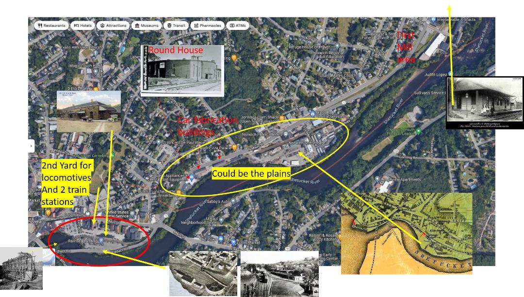
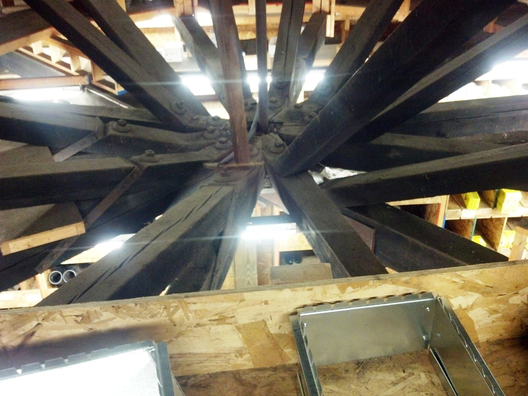
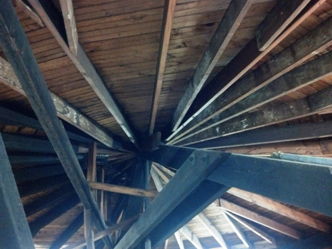
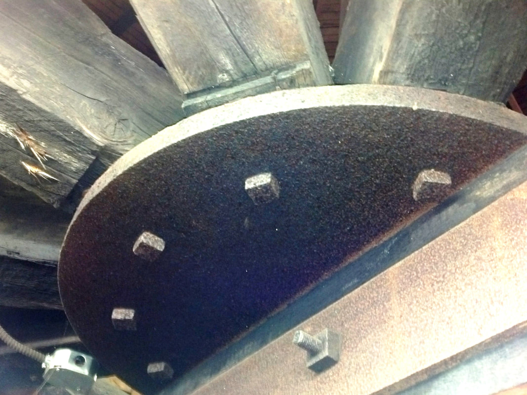
In this lower group Bob Ladd has given us this excellent overview of the area today, with the likely groundbreaking site in the big oval. When we visited on 5/10/2013, this quarter roundhouse building was extant and still in use by the Granite Group, who have since moved. They graciously allowed us to come inside where we saw the fabulous, well-preserved roof structure with massive timbers and bracing over the domed turntable housing. This is one of, we think, only two comparable historical structures in this state, the others being the two-stall engine house at Guilford, still crumbling last we knew, and the three-stall roundhouse in Putnam which is in commercial use. At Willimantic the Connecticut Eastern Railroad Museum has built an exact replica of the NYNH&H structure. See GUILFORD3, photo 3, PUTNAM4 photo 6, AIR LINE JUNCTION, photo 4. Bob Ladd lives nearby and is going to visit this location soon and give us an update. The Norwich community seems to value its history greatly -- see Bob's Facebook page Norwich Ct.Pictures,USA -- and hopefully this structure will be preserved for posterity! [added 092522]
|
|
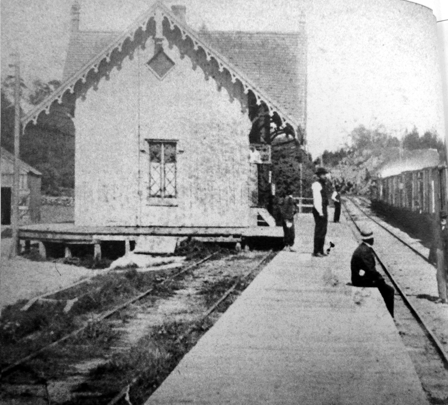
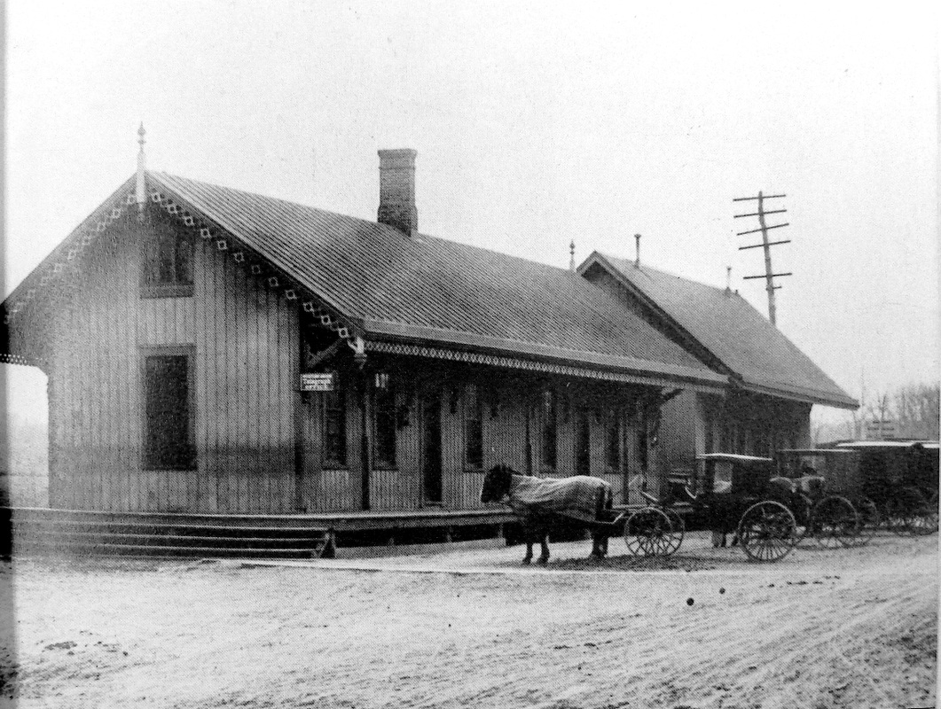
GREENWICH1 [NY&NH, 1848, WB]
Though we have found no documentary evidence, all the images we have for the 1848 original NY&NH stations consistently show this Gothic, cross-gable style. The image on the right appeared in Connecticut Circle magazine in September of 1946 [p12]. See the virtually identical design at NORWALK1, SOUTHPORT1, STRATFORD1, and WEST HAVEN1. With this evidence, we think it likely that the stations for which we do not have photos yet all shared this classic American depot style.
Though we have found no documentary evidence, all the images we have for the 1848 original NY&NH stations consistently show this Gothic, cross-gable style. The image on the right appeared in Connecticut Circle magazine in September of 1946 [p12]. See the virtually identical design at NORWALK1, SOUTHPORT1, STRATFORD1, and WEST HAVEN1. With this evidence, we think it likely that the stations for which we do not have photos yet all shared this classic American depot style.
Connecticut Historical Society
GREENWICH2 [NYNH&H, 1873, WB]
John Roy says the station here was a double building and apparently this is it. The 1873 build date, as documented by the railroad commissioners in their annual report issued the following year, may just apply to the left wing. We wonder if the far building is not GREENWICH1 shorn of its gables. [CC/01/03/1874/04; CRC21.1874.19; R57][rev011813]
John Roy says the station here was a double building and apparently this is it. The 1873 build date, as documented by the railroad commissioners in their annual report issued the following year, may just apply to the left wing. We wonder if the far building is not GREENWICH1 shorn of its gables. [CC/01/03/1874/04; CRC21.1874.19; R57][rev011813]
Dave Peters Collection
|

|
GREENWICH3 [NYNH&H, 1895, WB]
The new westbound station was a large saltbox style probably built in 1895. A report in 1893 said that the NYNH&H was going to build "a fine new stone depot" here but apparently that proved untrue. This structure stood until it was demolished in 1969 and replaced with GREENWICH5. [REFS: HC/12/13/1893/08; NHER/08/05/1895/01: eastbound(?)]
The new westbound station was a large saltbox style probably built in 1895. A report in 1893 said that the NYNH&H was going to build "a fine new stone depot" here but apparently that proved untrue. This structure stood until it was demolished in 1969 and replaced with GREENWICH5. [REFS: HC/12/13/1893/08; NHER/08/05/1895/01: eastbound(?)]

GREENWICH4 [NYNH&H, 1904, EB]
This was the new hip-roofed, eastbound station built in 1904, as mentioned by the railroad commissioners. [REFS: CRC52.1904.20; NHAR33.1904.4; R57]
This was the new hip-roofed, eastbound station built in 1904, as mentioned by the railroad commissioners. [REFS: CRC52.1904.20; NHAR33.1904.4; R57]

Wikipedia
GREENWICH5 [PC, 1970, WB]
This large, stucco and terra cotta, mall-like structure includes some retail shops. It opened on 3/5/1970. [REFS: HC/03/06/1970/21; R57][rev032113]
This large, stucco and terra cotta, mall-like structure includes some retail shops. It opened on 3/5/1970. [REFS: HC/03/06/1970/21; R57][rev032113]
John Roy photo
GREENWICH6 [PC, 1970, EB]
This is a smaller companion structure for the westbound station. [REFS: R57][rev011813]
This is a smaller companion structure for the westbound station. [REFS: R57][rev011813]
Dave Peters Collection
|

|
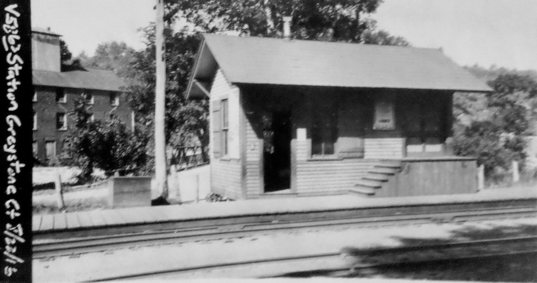
GREYSTONE [HP&F, 1855; opened as HOADLEYS]
Stop in the town of Plymouth and originally known as HOADLEYS on the opening of the HP&F line from Bristol to Waterbury in 1855.
Stop in the town of Plymouth and originally known as HOADLEYS on the opening of the HP&F line from Bristol to Waterbury in 1855.
|
National Archives
|
National Archives
|
UConn Archives & Spec. Collections
|
Bloomfield Historical Society
|
|
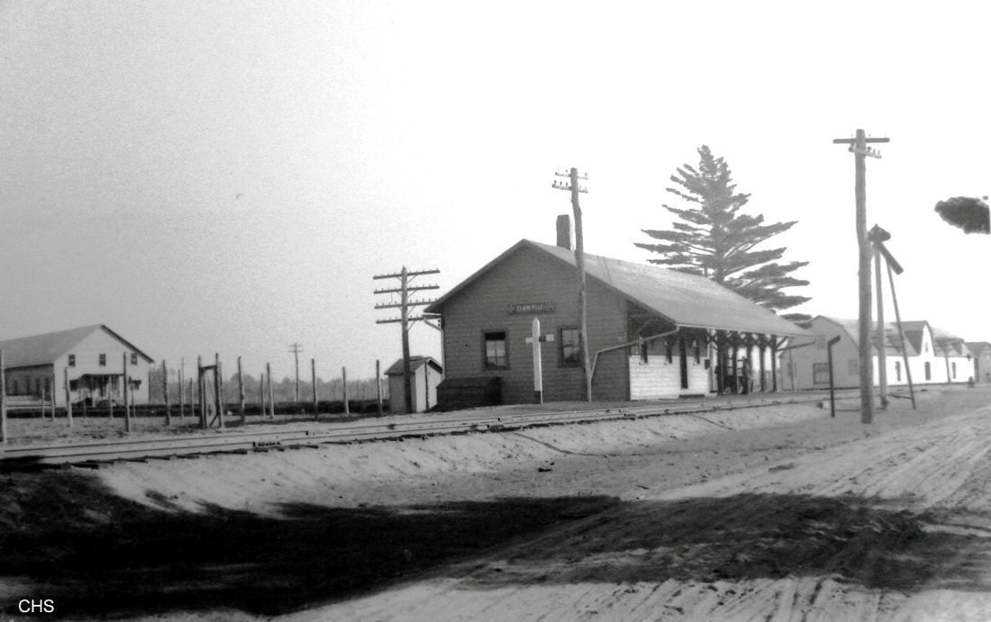
GRIFFINS [CNE, 1910; opens as CLARKVILLE, depot 1912]
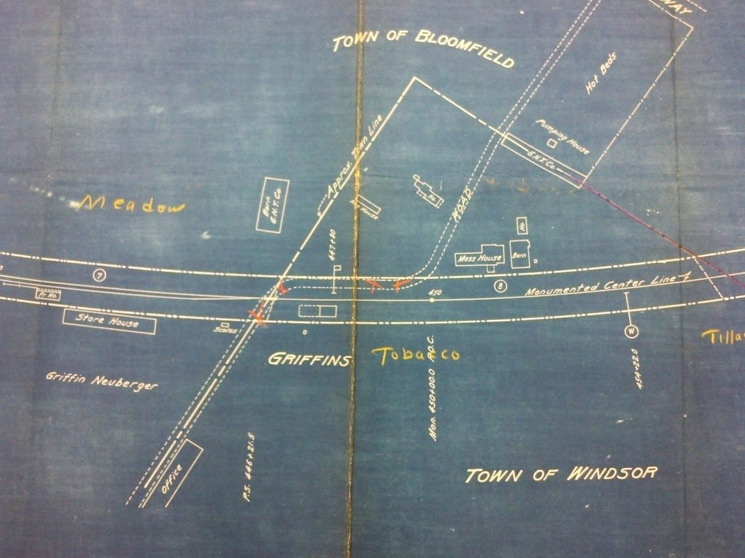
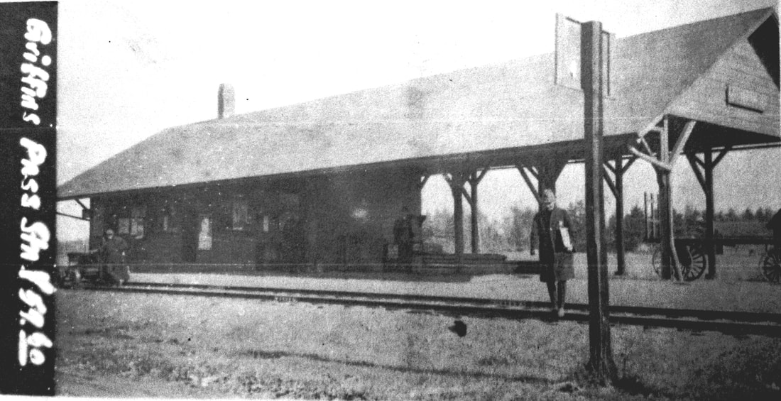
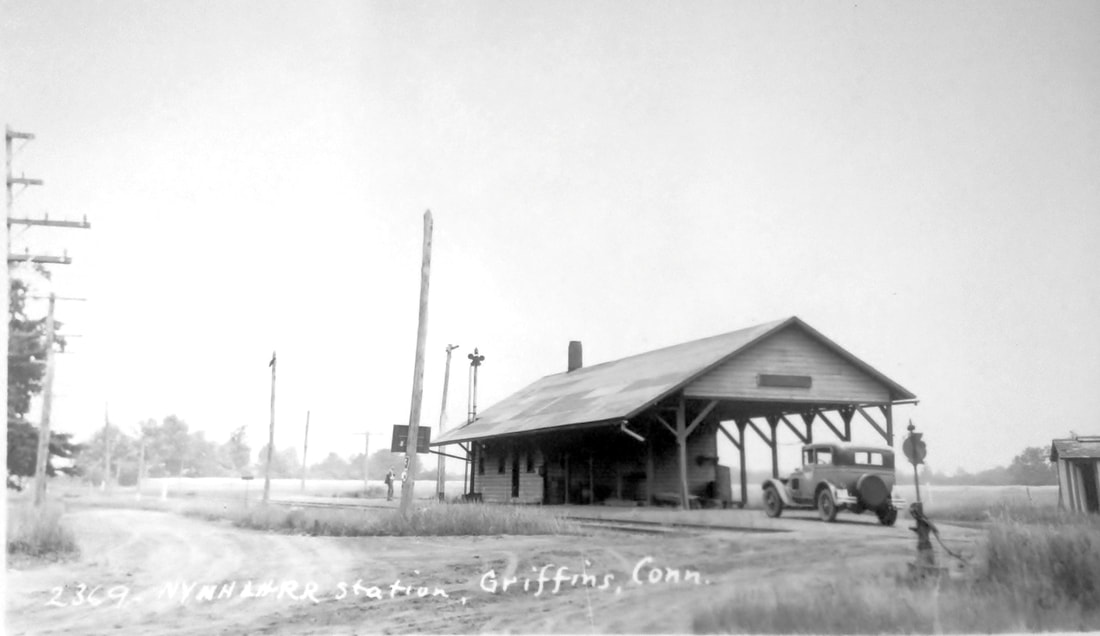
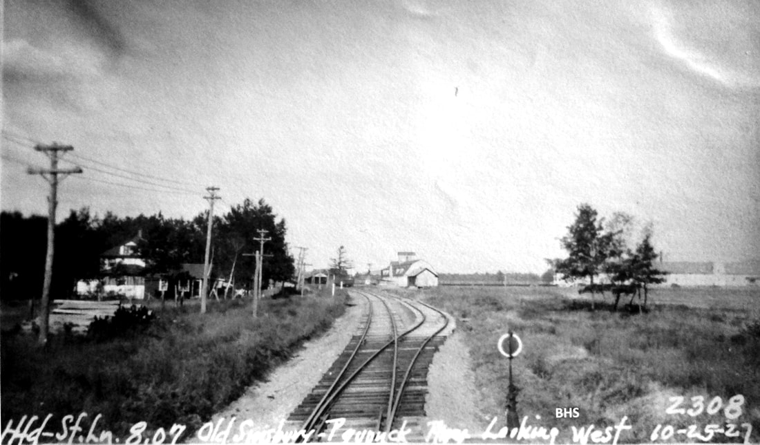
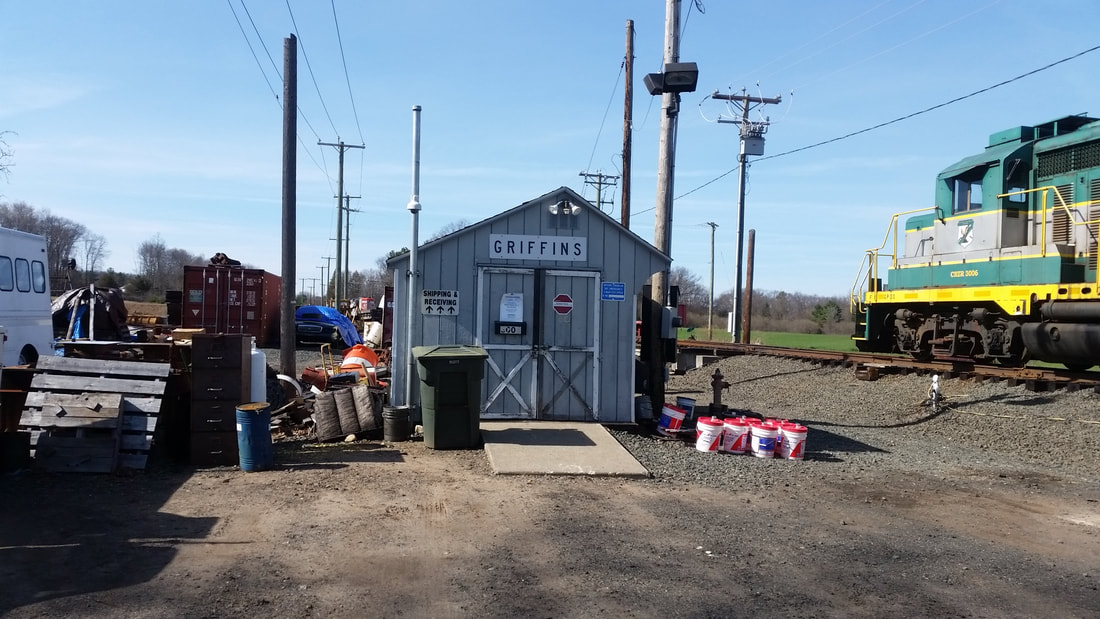
This depot stood in the extreme southwest corner of the town of Windsor where it borders Bloomfield. A request for a stop here was first made in 1903 by the International Tobacco Co., presumably for the convenience of employees working in the area, but nothing shows on a timetable until June, 1910. The immediate area was already known as Clarkville for pioneer tobacco grower Gene Clark and the stop was named accordingly. Nimke says the substantial structure seen here was built in 1913 but a Courant article to which we defer says "a fine station is in process of erection" on 12/2/1911. The signboard name says CLARKVILLE in the photo at [1]; the paddle is down to stop the train for the passenger waiting under the canopy. Assuming a 1912 build date, this image can only date from early in that year to 11/16/1915 when the station name was changed to GRIFFINS. This was per ICC order F-1611 to eliminate station names that were redundant and possibly confusing to train crews. The Griffin-Neuberger Tobacco Co. farm just to the south appears to have been chosen for the new name. The operation, presumably the largest local railroad customer, employed around 300 people and had multiple buildings for housing and feeding workers and for storing and processing the tobacco. The mess house is seen on the 1916 ICC val map at [2]. The depot footprint just above GRIFFINS shows the southern half with a dashed line for the canopied freight area, an unusual design feature of this station. The small flag symbol at the north end of the station is the paddle-on-post signal to stop the train. The map also shows that the structure sat in the southeast quadrant of the grade crossing for today's Day Hill Rd. The val photo at [3] probably also dates to 1916; the gentleman in the foreground may be an ICC field examiner. Note also the man leaning against the speeder car at far left. The image at [4] is Lewis H. Benton's 2369th shot, taken in June, 1929. Irving Drake's sedan is parked in the foreground and Drake himself is standing farther up-track, possibly chatting up a local. The 10/25/1927 PUC shot at [5] looks railroad west/compass north at the station in the middle distance. Passenger service ended in 1927. Nimke has perhaps the last photo taken of this station by George Phelps in 1937. Trackage north to TARIFFVILLE was abandoned in 1938. Freight service to Hartford endures to this day in 2018 with this location now the headquarters of A.J. Belliveau's reincarnated Central New England RR, as seen at [6]. The Track 11 Google Earth map snippet at [7] shows the area today. According to the SSRR list, the station along with the covershed was sold on 5/19/1938 to a C.L. Sargent for $25. Further disposition is not known. [REFS: HC/06/20/1903/13; CNE rev12/26/1909TT: no; LW rev6/12/1910TT: yes; HC/12/02/1911/06; HC/11/04/1915/17(?); D17,43; N3.10,46][rev013118]
This depot stood in the extreme southwest corner of the town of Windsor where it borders Bloomfield. A request for a stop here was first made in 1903 by the International Tobacco Co., presumably for the convenience of employees working in the area, but nothing shows on a timetable until June, 1910. The immediate area was already known as Clarkville for pioneer tobacco grower Gene Clark and the stop was named accordingly. Nimke says the substantial structure seen here was built in 1913 but a Courant article to which we defer says "a fine station is in process of erection" on 12/2/1911. The signboard name says CLARKVILLE in the photo at [1]; the paddle is down to stop the train for the passenger waiting under the canopy. Assuming a 1912 build date, this image can only date from early in that year to 11/16/1915 when the station name was changed to GRIFFINS. This was per ICC order F-1611 to eliminate station names that were redundant and possibly confusing to train crews. The Griffin-Neuberger Tobacco Co. farm just to the south appears to have been chosen for the new name. The operation, presumably the largest local railroad customer, employed around 300 people and had multiple buildings for housing and feeding workers and for storing and processing the tobacco. The mess house is seen on the 1916 ICC val map at [2]. The depot footprint just above GRIFFINS shows the southern half with a dashed line for the canopied freight area, an unusual design feature of this station. The small flag symbol at the north end of the station is the paddle-on-post signal to stop the train. The map also shows that the structure sat in the southeast quadrant of the grade crossing for today's Day Hill Rd. The val photo at [3] probably also dates to 1916; the gentleman in the foreground may be an ICC field examiner. Note also the man leaning against the speeder car at far left. The image at [4] is Lewis H. Benton's 2369th shot, taken in June, 1929. Irving Drake's sedan is parked in the foreground and Drake himself is standing farther up-track, possibly chatting up a local. The 10/25/1927 PUC shot at [5] looks railroad west/compass north at the station in the middle distance. Passenger service ended in 1927. Nimke has perhaps the last photo taken of this station by George Phelps in 1937. Trackage north to TARIFFVILLE was abandoned in 1938. Freight service to Hartford endures to this day in 2018 with this location now the headquarters of A.J. Belliveau's reincarnated Central New England RR, as seen at [6]. The Track 11 Google Earth map snippet at [7] shows the area today. According to the SSRR list, the station along with the covershed was sold on 5/19/1938 to a C.L. Sargent for $25. Further disposition is not known. [REFS: HC/06/20/1903/13; CNE rev12/26/1909TT: no; LW rev6/12/1910TT: yes; HC/12/02/1911/06; HC/11/04/1915/17(?); D17,43; N3.10,46][rev013118]
Thompson Historical Society
|
Thompson Historical Society
|
|
|
|
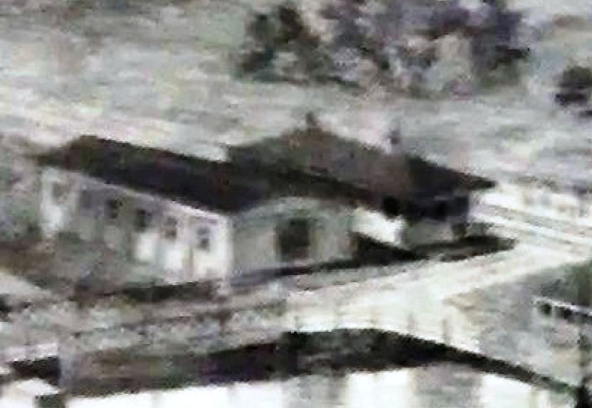
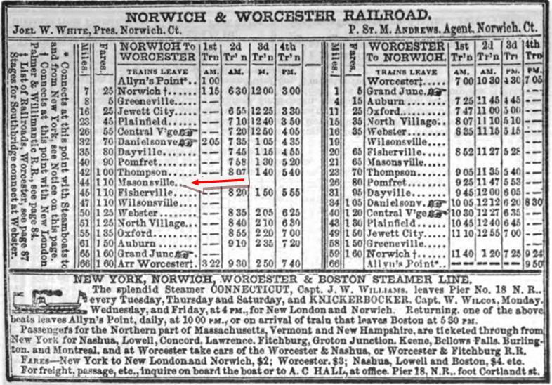
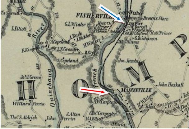
GROSVENORDALE1 [N&W, 1840; opened as MASONVILLE]
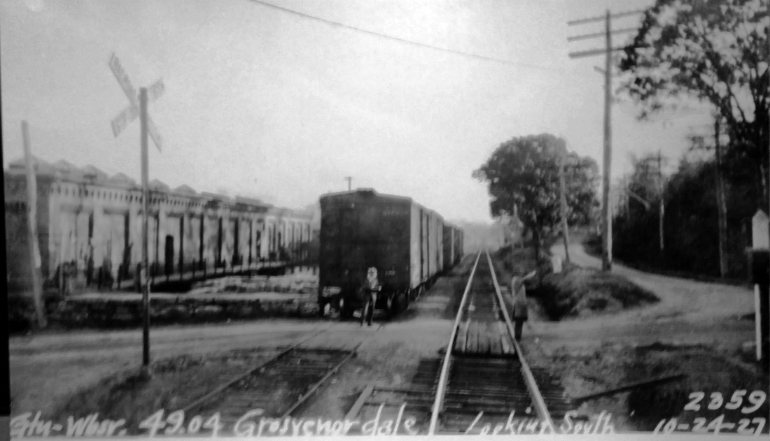
This station was in the town of THOMPSON. The view at upper left dates to 1877 and shows a depot with a hipped roof and two chimneys, a close-up of which is seen at upper middle. The N&W opened through the town of Thompson in 1840 but the earliest timetable we have is 1851, seen at upper right, and it shows this stop by its earlier name. The depot is not found at our red arrow on the 1856WC map at lower left but the location is seen on the 1869 map at lower right. The ten villages in this town were mostly all mill-related in some way, dating at least back to 1813 when the Mason family built a small cotton mill on the French River. The name of this station was probably changed in 1868 when then-owner Dr. William Grosvenor merged the Masonville and Fisherville Cos. as the Grosvenordale Co. and similarly, the station in FISHERVILLE at the blue arrow likely became NORTH GROSVENORDALE also at that time. In 1872, a huge steam-powered cotton mill was added and by 1900, this combined complex was the biggest mill and employer in Windham County with 1,750 employees. [REFS: SR/11/09/1869/04; CC/11/13/1869/01][rev071813]
This station was in the town of THOMPSON. The view at upper left dates to 1877 and shows a depot with a hipped roof and two chimneys, a close-up of which is seen at upper middle. The N&W opened through the town of Thompson in 1840 but the earliest timetable we have is 1851, seen at upper right, and it shows this stop by its earlier name. The depot is not found at our red arrow on the 1856WC map at lower left but the location is seen on the 1869 map at lower right. The ten villages in this town were mostly all mill-related in some way, dating at least back to 1813 when the Mason family built a small cotton mill on the French River. The name of this station was probably changed in 1868 when then-owner Dr. William Grosvenor merged the Masonville and Fisherville Cos. as the Grosvenordale Co. and similarly, the station in FISHERVILLE at the blue arrow likely became NORTH GROSVENORDALE also at that time. In 1872, a huge steam-powered cotton mill was added and by 1900, this combined complex was the biggest mill and employer in Windham County with 1,750 employees. [REFS: SR/11/09/1869/04; CC/11/13/1869/01][rev071813]
National Archives
|
|
National Archives
|

|
Ed Deluca Collection
|
Ed Deluca Collection
|
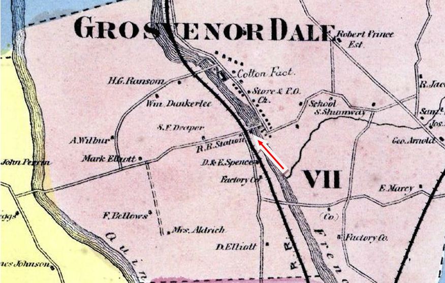
GROSVENORDALE2 [N&W, c1870?]
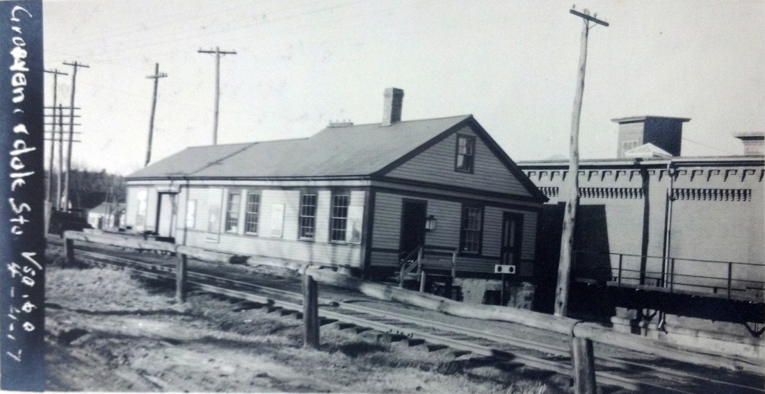
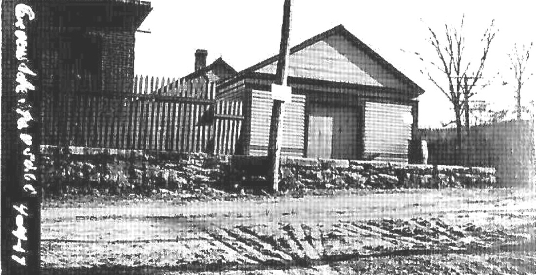
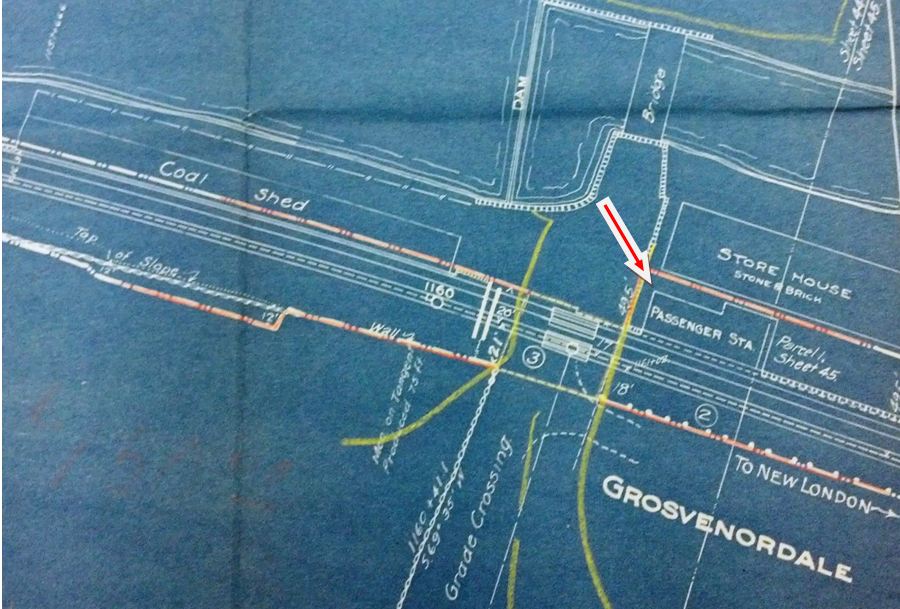
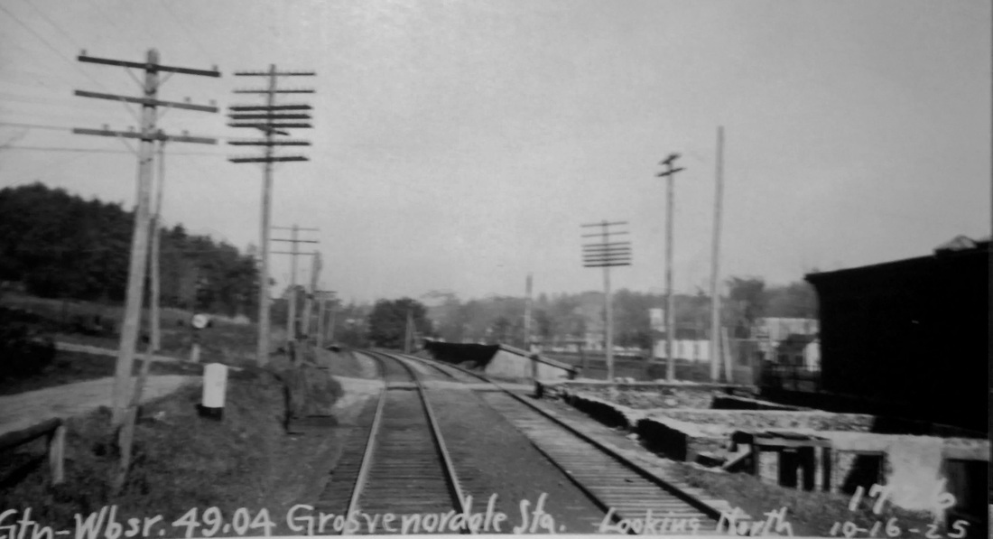
We have no information as to when this station was built. It has a profile similar to NORTH GROSVENORDALE2 but differences can be seen. There is no operator's bay here, there is a south-side entrance and a different door and window configuration. The val photos at upper left and middle show front and rear views and are dated 4/4/1917, the same as other ICC shots taken in the area. The 1915 val map at upper right shows the layout of the station area at that time. The image at lower left is undated but apparently has to be prior to 1925, since the 10/26/1925 and 10/24/1927 PUC photos show this station to have been gone by that time. GROSVENORDALE is listed on our 6/29/1919LETT but is not on the the 5/4/1925LETT, the next in our collection. The railroad commissioners gave their assent in 1909 to a plan to abandon both Grosvenordale stations and to build a new intermediate depot, and while this was never done, perhaps the later elimination of this station alone was the result. The string of boxcars in the last photo shows that there was still freight business to be done here, perhaps with the railroad renting space for an agent in the adjacent brick storehouse building. What actually happened to GROSVENORDALE2 is not yet known. [REFS: RRC40.252; CRC57.1909.31; HC/12/04/1909/06][rev121513]
We have no information as to when this station was built. It has a profile similar to NORTH GROSVENORDALE2 but differences can be seen. There is no operator's bay here, there is a south-side entrance and a different door and window configuration. The val photos at upper left and middle show front and rear views and are dated 4/4/1917, the same as other ICC shots taken in the area. The 1915 val map at upper right shows the layout of the station area at that time. The image at lower left is undated but apparently has to be prior to 1925, since the 10/26/1925 and 10/24/1927 PUC photos show this station to have been gone by that time. GROSVENORDALE is listed on our 6/29/1919LETT but is not on the the 5/4/1925LETT, the next in our collection. The railroad commissioners gave their assent in 1909 to a plan to abandon both Grosvenordale stations and to build a new intermediate depot, and while this was never done, perhaps the later elimination of this station alone was the result. The string of boxcars in the last photo shows that there was still freight business to be done here, perhaps with the railroad renting space for an agent in the adjacent brick storehouse building. What actually happened to GROSVENORDALE2 is not yet known. [REFS: RRC40.252; CRC57.1909.31; HC/12/04/1909/06][rev121513]
|

|
|
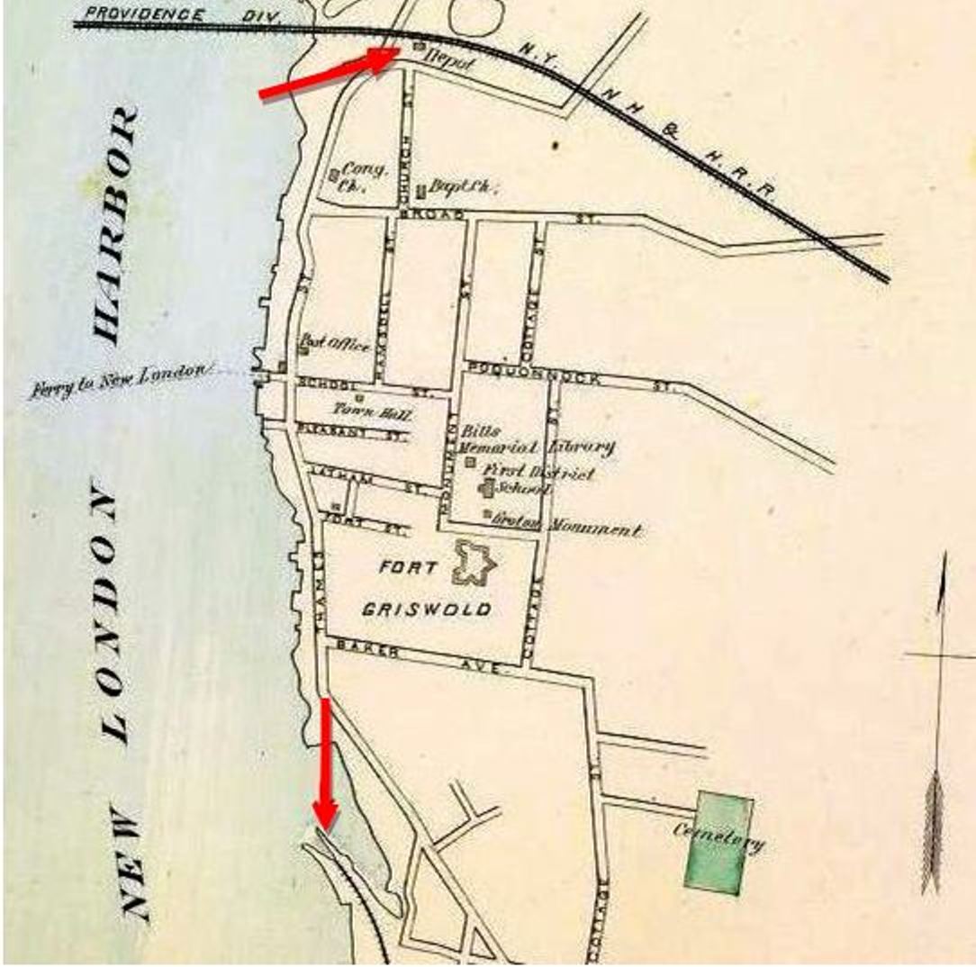
GROTON1 [NL&S, 1858; depot, 1860]
Also known as GROTON BANK, this terminus was established by the NL&S late in 1858. The 1868 Beers atlas at [1] shows the layout in that year at the end of the extension from Stonington, the lower track on the 1893 map at [2]. From this point traffic was to be ferried across the harbor to connect with the NH&NL in New London. The two roads then merged to form the NHNL&S which was leased by the NYP&B. Whatever was here in 1859 was greatly supplemented to produce a 300x50-ft structure with two tracks running through it, similar to the appearance of STONINGTON2 whose image we have copied here at [3]. An eight-stall engine house and other structures were also to be built here, with service to begin on 9/17/1860. Supplanting the Stonington terminus for boats to New York, this facility served until it was destroyed by an 1865 fire that saw the steamer Commonwealth “burned to the water’s edge” and a large number of rail cars lost as well. With the NYP&B already contemplating the abandonment in favor of newer facilities back at Stonington, it nevertheless paid $400,000 to the NHNL&S, newly organized as the Shore Line RR, to buy the line from Stonington to Groton for through rail traffic. [REFS: HDC/08/30/1860/02; NLDC/09/15/1860/03; HDC/12/17/1864/02; MP/12/30/1865/02][rev112815]
Also known as GROTON BANK, this terminus was established by the NL&S late in 1858. The 1868 Beers atlas at [1] shows the layout in that year at the end of the extension from Stonington, the lower track on the 1893 map at [2]. From this point traffic was to be ferried across the harbor to connect with the NH&NL in New London. The two roads then merged to form the NHNL&S which was leased by the NYP&B. Whatever was here in 1859 was greatly supplemented to produce a 300x50-ft structure with two tracks running through it, similar to the appearance of STONINGTON2 whose image we have copied here at [3]. An eight-stall engine house and other structures were also to be built here, with service to begin on 9/17/1860. Supplanting the Stonington terminus for boats to New York, this facility served until it was destroyed by an 1865 fire that saw the steamer Commonwealth “burned to the water’s edge” and a large number of rail cars lost as well. With the NYP&B already contemplating the abandonment in favor of newer facilities back at Stonington, it nevertheless paid $400,000 to the NHNL&S, newly organized as the Shore Line RR, to buy the line from Stonington to Groton for through rail traffic. [REFS: HDC/08/30/1860/02; NLDC/09/15/1860/03; HDC/12/17/1864/02; MP/12/30/1865/02][rev112815]
GROTON2 [NYP&B, 1864]
This was a small station erected at Groton Bank after the 1865 fire. This continued to be the steamboat terminus for New York traffic until 1/8/1866 when the boats again docked at Stonington. Even thereafter, Groton Bank continued to be the transfer point for traffic to and from New London between the SLRR and the NYP&B until the Thames River bridge was built in 1889. The upper line on the 1893 map in the previous entry was built at that time to meet the new bridge from a point that would become known as POQUONNOCK JUNCTION. We have no photograph of GROTON2. [REFS: HDC/01/09/1866/02]
This was a small station erected at Groton Bank after the 1865 fire. This continued to be the steamboat terminus for New York traffic until 1/8/1866 when the boats again docked at Stonington. Even thereafter, Groton Bank continued to be the transfer point for traffic to and from New London between the SLRR and the NYP&B until the Thames River bridge was built in 1889. The upper line on the 1893 map in the previous entry was built at that time to meet the new bridge from a point that would become known as POQUONNOCK JUNCTION. We have no photograph of GROTON2. [REFS: HDC/01/09/1866/02]
Dave Peters Collection
|
|
|
|
|
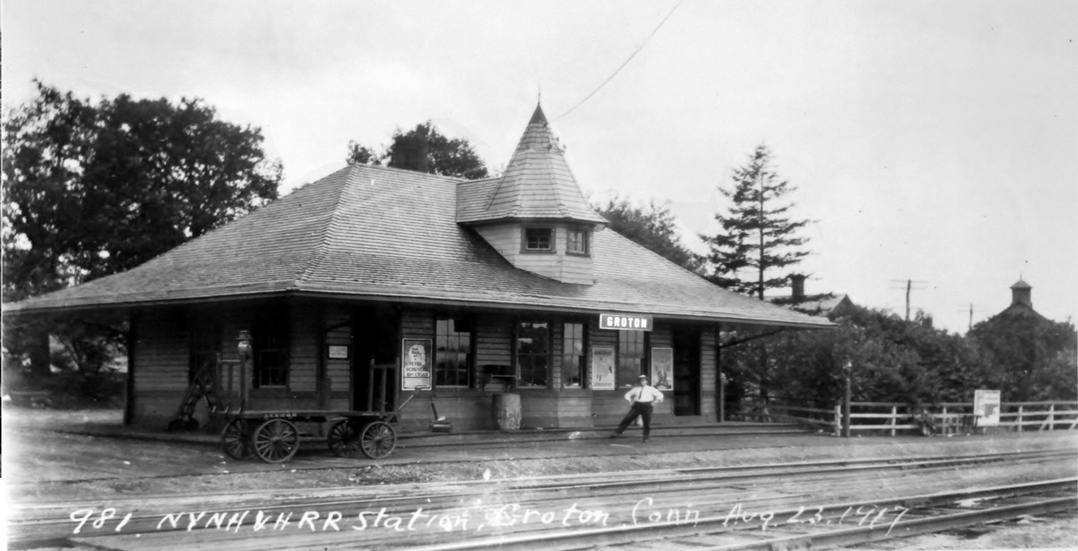
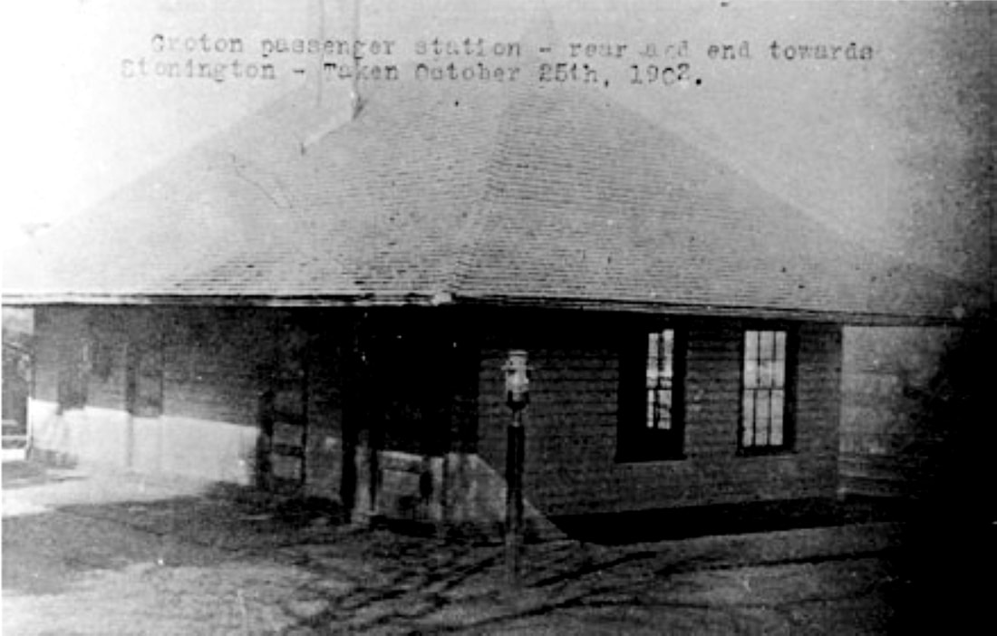
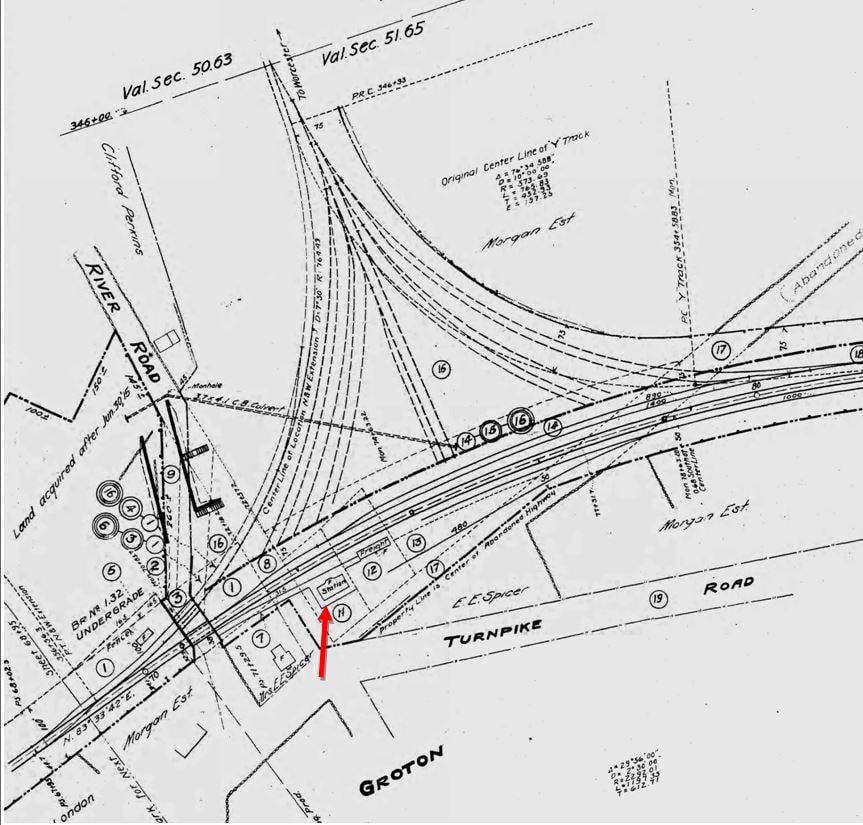
GROTON3 [NYNH&H, 1889]
The eastward-looking val photo at [1] is dated 4/12/1917 and the westward shot at [2] is Lewis H. Benton #981 taken on 8/23/1917 with dated inscription. This station was built on the relocated Shore Line to meet the new bridge across the Thames River that opened on 10/10/1889. When the old boat Groton, which had plied the waters between the shores for the last 30 years, steamed under the new bridge, according to the Register, its whistle tooted its own funeral dirge, at which time all the flags on the new bridge were unfurled. "Then came a dint such as New London had never heard before," with the whistles on tugs, steam yachts and assembled locomotives blown at once. Crowds on both shores cheered and cannons fired as the Shore Line became all-rail for the first time in history. In the 1893 map at [3], GROTON3 is at the upper red arrow and the site of GROTON1 is at the lower arrow. The old trackage to the steamboat landing was retained and is still in use today to serve Pfizer and a fuel storage facility. The photo at [4] is a 10/25/1902 rear view of the station; the caption is erroneous in that the view is toward New London, not Stonington. You have to look closely at the middle of the roof to see the outline of the turret on the front of this attractive and uniquely designed structure, somewhat reminiscent of BRANFORD3. The 1915 val map at [5] shows the station at our red arrow, south of the track where the west leg of the wye connected the N&W with the Shore Line in 1899. The 1938 SSRR list has this station as retired and subject to sale, removal or razing. [REFS: HDC/08/31/1882/04: new depot(?); NHER/10/10/1889/01][rev010318, 122118]
The eastward-looking val photo at [1] is dated 4/12/1917 and the westward shot at [2] is Lewis H. Benton #981 taken on 8/23/1917 with dated inscription. This station was built on the relocated Shore Line to meet the new bridge across the Thames River that opened on 10/10/1889. When the old boat Groton, which had plied the waters between the shores for the last 30 years, steamed under the new bridge, according to the Register, its whistle tooted its own funeral dirge, at which time all the flags on the new bridge were unfurled. "Then came a dint such as New London had never heard before," with the whistles on tugs, steam yachts and assembled locomotives blown at once. Crowds on both shores cheered and cannons fired as the Shore Line became all-rail for the first time in history. In the 1893 map at [3], GROTON3 is at the upper red arrow and the site of GROTON1 is at the lower arrow. The old trackage to the steamboat landing was retained and is still in use today to serve Pfizer and a fuel storage facility. The photo at [4] is a 10/25/1902 rear view of the station; the caption is erroneous in that the view is toward New London, not Stonington. You have to look closely at the middle of the roof to see the outline of the turret on the front of this attractive and uniquely designed structure, somewhat reminiscent of BRANFORD3. The 1915 val map at [5] shows the station at our red arrow, south of the track where the west leg of the wye connected the N&W with the Shore Line in 1899. The 1938 SSRR list has this station as retired and subject to sale, removal or razing. [REFS: HDC/08/31/1882/04: new depot(?); NHER/10/10/1889/01][rev010318, 122118]
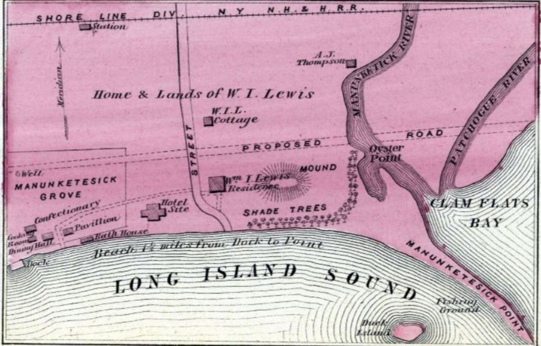
Historic Map Works
|

|
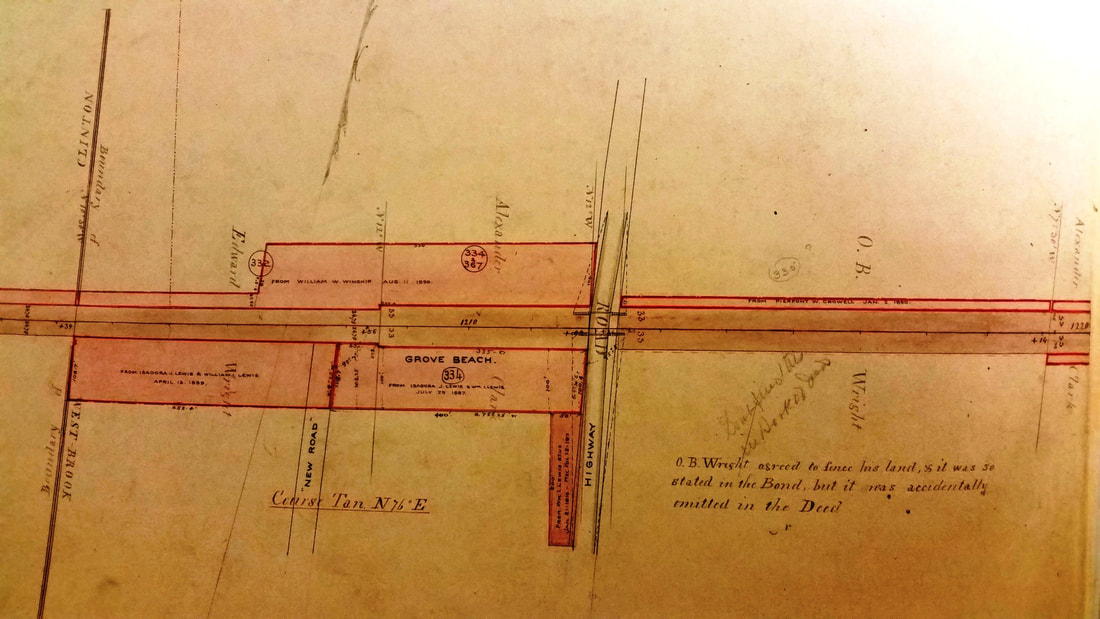
New Haven Museum
|
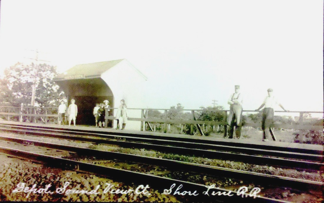
GROVE BEACH1 [NYNH&H, ca. 1872]
This locale on the western border of the town of Westbrook was named for the thickly forested grove of trees that reached almost down to the water. A special train stop was in existence at least by 1873 and is reflected by the word 'station' on the 1874 Beers map at [1], which also shows the facilities for which people were coming, sometimes in droves. When a reporter arrived from New Haven in August, 1884, he said that he witnessed "... at Grove Beach station... a large excursion of twelve car loads... from New London [which] kept the skating rink and restaurant lively generally." He went on to say that "... we understand that very favorable rates are given to Sabbath schools, etc. from any point on the consolidated [sic] road" and that "... this place has built up in a day, as it were...," that 'day' being 1884 when suddenly a post office was established on the 16th of June, lots were being bought, and cottages were a-building, one even by Shore Line Division Supt. Shepard. This was all to the delight of Mr. William Isaac Lewis, who had inherited the family farm and land in 1872, had refurbished the facilities at the grove and also had thrown the area open for development. Eventually piers for steamer dockage were built and he would use his influence to change the course of the Post Road to run on a more southerly route closer to the grove. A LEWIS GROVE stop officially debuts on the railroad commission maps in 1884, as seen at [2], and remained so-named until the maps ceased in 1912 in spite of the fact that the railroad always called it GROVE BEACH. The image at [3] is from a Shore Line index map book in which the stop appears to be placed where the words are at the site of GROVE BEACH1, but with no platform or station shown. The GBIA's Century book says there was a only platform here initially but we wonder if there was over time not a small shelter like SOUND VIEW1 seen at [4]. In November, 1886 we read that "... a small house has been erected at the depot for accommodation of the U.S. mail carrier." With both the words depot and station used, we think that some structure was in place here but even with only a platform, this would have to be considered a 'station,' GROVE BEACH1, in use for over a decade before GROVE BEACH2 was built in the same spot. [REFS: CR/08/02/1873/03; County Atlas of Middlesex, Connecticut, 1874; RRM1884-1912: Lewis Grove; HDC/08/18/1884/04; PP/11/24/1886/3; rev7/15/1894TT: yes; Grove Beach Improvement Association, A Century at Grove Beach, 1895-1995][rev122418]
This locale on the western border of the town of Westbrook was named for the thickly forested grove of trees that reached almost down to the water. A special train stop was in existence at least by 1873 and is reflected by the word 'station' on the 1874 Beers map at [1], which also shows the facilities for which people were coming, sometimes in droves. When a reporter arrived from New Haven in August, 1884, he said that he witnessed "... at Grove Beach station... a large excursion of twelve car loads... from New London [which] kept the skating rink and restaurant lively generally." He went on to say that "... we understand that very favorable rates are given to Sabbath schools, etc. from any point on the consolidated [sic] road" and that "... this place has built up in a day, as it were...," that 'day' being 1884 when suddenly a post office was established on the 16th of June, lots were being bought, and cottages were a-building, one even by Shore Line Division Supt. Shepard. This was all to the delight of Mr. William Isaac Lewis, who had inherited the family farm and land in 1872, had refurbished the facilities at the grove and also had thrown the area open for development. Eventually piers for steamer dockage were built and he would use his influence to change the course of the Post Road to run on a more southerly route closer to the grove. A LEWIS GROVE stop officially debuts on the railroad commission maps in 1884, as seen at [2], and remained so-named until the maps ceased in 1912 in spite of the fact that the railroad always called it GROVE BEACH. The image at [3] is from a Shore Line index map book in which the stop appears to be placed where the words are at the site of GROVE BEACH1, but with no platform or station shown. The GBIA's Century book says there was a only platform here initially but we wonder if there was over time not a small shelter like SOUND VIEW1 seen at [4]. In November, 1886 we read that "... a small house has been erected at the depot for accommodation of the U.S. mail carrier." With both the words depot and station used, we think that some structure was in place here but even with only a platform, this would have to be considered a 'station,' GROVE BEACH1, in use for over a decade before GROVE BEACH2 was built in the same spot. [REFS: CR/08/02/1873/03; County Atlas of Middlesex, Connecticut, 1874; RRM1884-1912: Lewis Grove; HDC/08/18/1884/04; PP/11/24/1886/3; rev7/15/1894TT: yes; Grove Beach Improvement Association, A Century at Grove Beach, 1895-1995][rev122418]
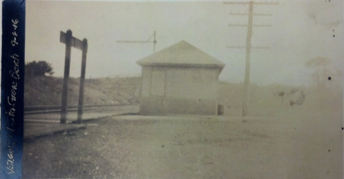
National Archives
|
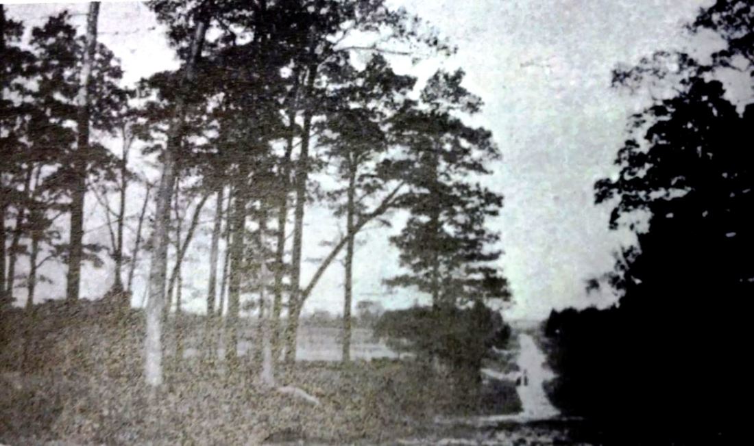
Grove Beach Improvement Assoc.
|
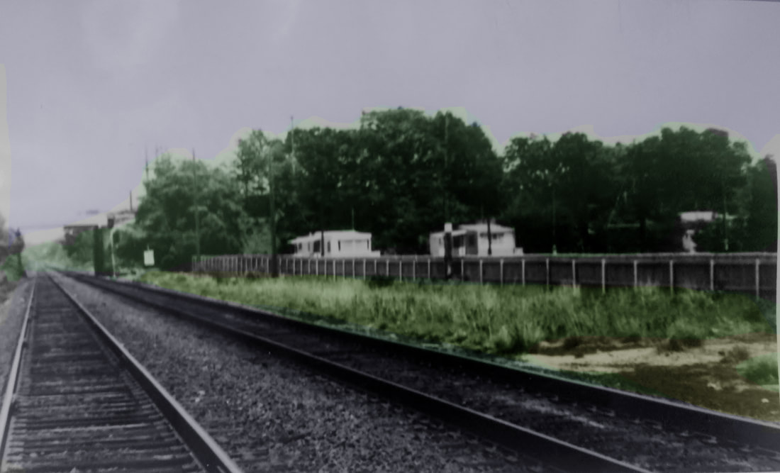
UConn Archives & Special Colls.
|
GROVE BEACH2 [NYNH&H, 1887]
In August, 1886 then-Supt. A.W. Waterbury was interviewed "in behalf of his people for a new depot at Grove Beach" and he promised to consider the matter. His people? Did he have a cottage here too? But for us the accent has to be on the word "new" which, based previous newspaper reports that made it sound like there was a depot here already, would mean an actual new building to replace the old one. It gets a little perplexing when Middletown's Penny Press ran an article a year later on 7/29/1887 making it sound like the coming depot was entirely new and that... "the greatest work ever attempted at this place is that of preliminary preparation being made by the [railroad]... for the construction of a depot." With 60 men working on the project, locals must have dropped their jaws. Our Mr. Lewis, of course, owned the land for the station: see GB1, image 3 where the sale date looks like 7/29/1887. He is also credited with building 'Broadway' from the depot down to the shore and with having the railroad level the hill south of the station so that the view was clear to the Sound. Lewis, and his wife, then commenced advertising as far away as Springfield for their rental cottages and lots for sale. With gaps in our timetable collection, the first appearance of GROVE BEACH we have is in 1894 and most all the trains, six each way daily, two on Sundays, in the summers of the early 1900s were on a flag-stop basis. The newspapers reported a string of burglaries at post offices and railroad stations that included one here in 1894. Shore Line stations in relatively isolated locations were frequent targets of thieves. On 9/17/1894, a duo posted a lookout while the "cracksman" went inside as Agent Herbert C. Stannard was home for breakfast. When Stannard "... hove into sight on his wheel [read bicycle], the men fled "... to Poison Swamp a vast and almost impenetrable morass adjoining the station on the west and extending about a quarter of a mile or so down the track." The nearly illegible information on the val photo at [1] indicates that this is the old station, still standing on 9/6/1916 and still railroad property for valuation purposes; what actual use it was serving (baggage, storage, section house?) at the time is unclear. In its simple, hip-roofed box style, it was similar to the 1903 SEA VIEW1 depot shown at GB1-4. The photo at [2] looks toward GROVE BEACH2, perhaps behind the trees at middle left. The image at [3] is from the Fran Donovan Collection at UConn. The site of GROVE BEACH1,2 is obvious in Al Weaver's colorization of this 1972 photo that looks east toward the Grove Beach Rd. overpass. [REFS: NHER/08/17/1886/04; PP/11/24/1886/03; SR/06/30/1887/01; PP/07/29/1887/03; HC/05/06/1890/06 ; HDC/09/20/1894/08; CEN/09/25/1894/02; NHER/02/26/1895/01; 1972: FDC 2:11][rev022813, 122418]
In August, 1886 then-Supt. A.W. Waterbury was interviewed "in behalf of his people for a new depot at Grove Beach" and he promised to consider the matter. His people? Did he have a cottage here too? But for us the accent has to be on the word "new" which, based previous newspaper reports that made it sound like there was a depot here already, would mean an actual new building to replace the old one. It gets a little perplexing when Middletown's Penny Press ran an article a year later on 7/29/1887 making it sound like the coming depot was entirely new and that... "the greatest work ever attempted at this place is that of preliminary preparation being made by the [railroad]... for the construction of a depot." With 60 men working on the project, locals must have dropped their jaws. Our Mr. Lewis, of course, owned the land for the station: see GB1, image 3 where the sale date looks like 7/29/1887. He is also credited with building 'Broadway' from the depot down to the shore and with having the railroad level the hill south of the station so that the view was clear to the Sound. Lewis, and his wife, then commenced advertising as far away as Springfield for their rental cottages and lots for sale. With gaps in our timetable collection, the first appearance of GROVE BEACH we have is in 1894 and most all the trains, six each way daily, two on Sundays, in the summers of the early 1900s were on a flag-stop basis. The newspapers reported a string of burglaries at post offices and railroad stations that included one here in 1894. Shore Line stations in relatively isolated locations were frequent targets of thieves. On 9/17/1894, a duo posted a lookout while the "cracksman" went inside as Agent Herbert C. Stannard was home for breakfast. When Stannard "... hove into sight on his wheel [read bicycle], the men fled "... to Poison Swamp a vast and almost impenetrable morass adjoining the station on the west and extending about a quarter of a mile or so down the track." The nearly illegible information on the val photo at [1] indicates that this is the old station, still standing on 9/6/1916 and still railroad property for valuation purposes; what actual use it was serving (baggage, storage, section house?) at the time is unclear. In its simple, hip-roofed box style, it was similar to the 1903 SEA VIEW1 depot shown at GB1-4. The photo at [2] looks toward GROVE BEACH2, perhaps behind the trees at middle left. The image at [3] is from the Fran Donovan Collection at UConn. The site of GROVE BEACH1,2 is obvious in Al Weaver's colorization of this 1972 photo that looks east toward the Grove Beach Rd. overpass. [REFS: NHER/08/17/1886/04; PP/11/24/1886/03; SR/06/30/1887/01; PP/07/29/1887/03; HC/05/06/1890/06 ; HDC/09/20/1894/08; CEN/09/25/1894/02; NHER/02/26/1895/01; 1972: FDC 2:11][rev022813, 122418]
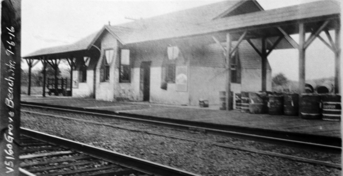
|
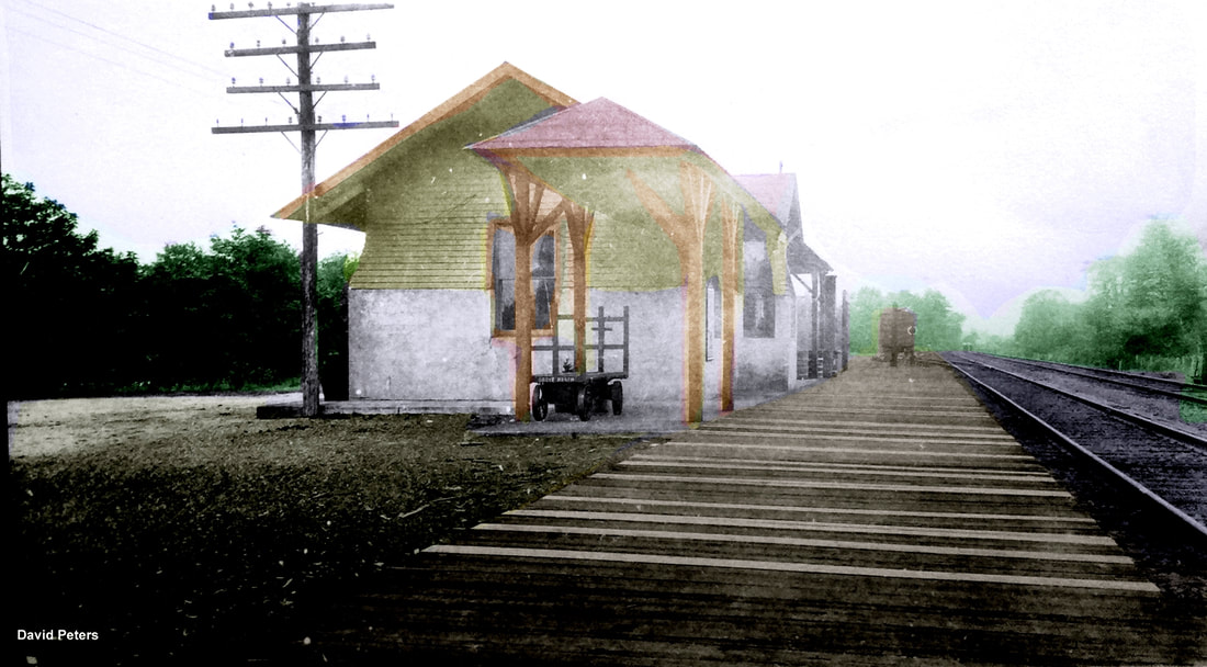
Dave Peters Collection
|
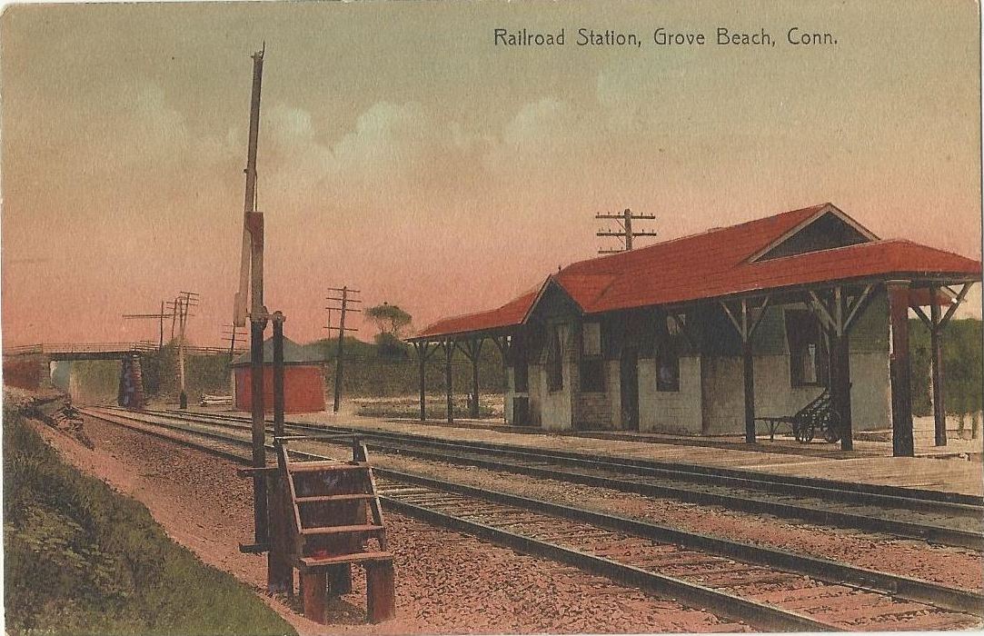
|
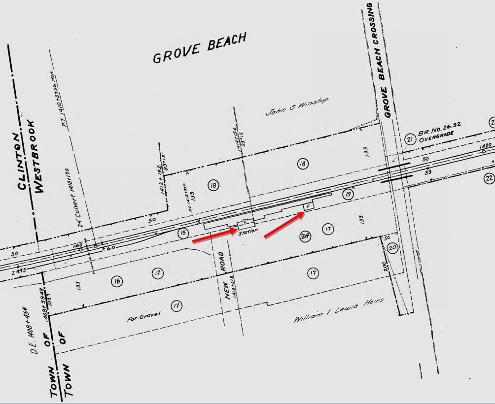
|
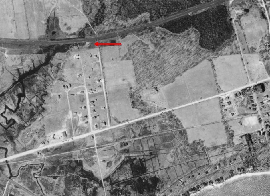
|

Grove Beach Improvement Assoc.
|
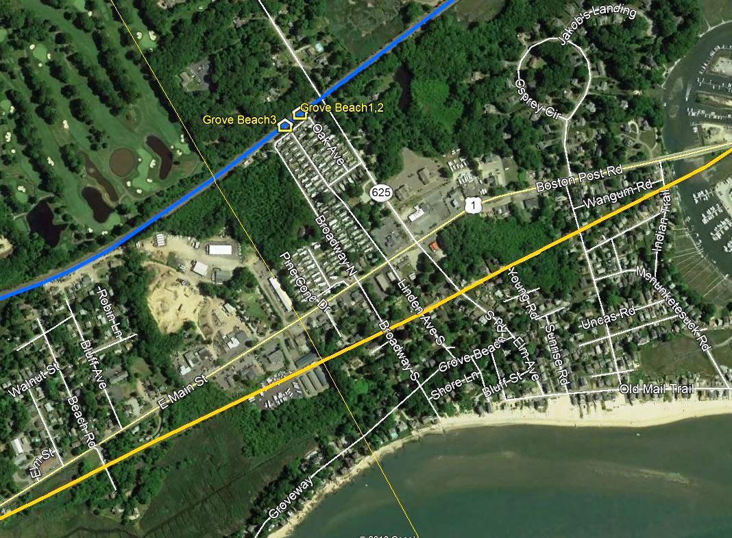
GROVE BEACH3 [NYNH&H, 1899]
This beautiful accommodation debuted in 1899. The railroad commissioners said rather blandly that "... a new passenger station building has been erected at Grove Beach," with no hint at all of its elegance, for a flag stop, no less! The 9/6/1916 val photo at [1] shows off the station's unique lines, quite in contrast to the ersatz, already dated-looking saltbox structures put up as CLINTON2 and MADISON2 at this time. We would love to more about who was responsible for the design of GROVE BEACH3, which is somewhat akin to WESTBROOK2. Undoubtedly the moving force behind the project was Mr. Lewis who must have looked upon this as the jewel in the crown of his success at The Grove. Once again he owned the land on which the station would be built just west of the the earlier one, which was left standing; see GB1, image 3 where the dates on the parcels west of GB1 appear to read 4/13/1899. Oddly enough, no newspaper articles have been found on the opening of the station for which Lewis must have pulled out all the stops. The shot at [2] is also a val photo of the same date with the black band cut off, a practice repugnant to us but done by some for 'aesthetic' reasons. Al Weaver's colorizations, although arbitrary, always sharpen the photo details: the construction of a newer platform is in progress; the fact that the depot was concrete at base and clapboarded from the middle to the roof; and the box car sitting west of the station on the siding. The beautiful card at [3] dates to ca. 1910 and gives a good view of the mail crane on the north side of the tracks. On the south side the card shows GROVE BEACH3, GROVE BEACH2 a little farther east and Grove Beach Rd crossing, bridged in 1890, a little beyond. The 1915 val map at [4] shows the layout of the grounds and the old and new stations at the red arrows. From 1909 to 1928 the Shore Line Electric Rwy also served this community and, with the fast, clean, frequent service that always gave the trolleys a big edge over the steam railroad, killed traffic at GROVE BEACH3. By 1923, the Century book says no trains were stopping here. The 1934 aerial at [5] is not very clear but may only show GROVE BEACH2. By the time the 1938 SSRR retirement list was compiled, the only structure here to be disposed of was the section house. The physical fate of GROVE BEACH3 is unknown to us at this time but the Hurricane of 1938, which wiped out all the cottages, may have brought the end to this stately station. Our Mr. Lewis died on 1/1/1915. In addition to his real-estate exploits, he had distinguished himself as a Civil War volunteer and prisoner, as sergeant-at-arms in the U.S. Senate, and U.S. post office inspector for Connecticut. [REFS: CRC47.1899.29; NHAR, 1899, 1900: no; HC/05/06/1890/06; HC//01/02/1915/21; HC/09/24/1938/04][rev122418]
This beautiful accommodation debuted in 1899. The railroad commissioners said rather blandly that "... a new passenger station building has been erected at Grove Beach," with no hint at all of its elegance, for a flag stop, no less! The 9/6/1916 val photo at [1] shows off the station's unique lines, quite in contrast to the ersatz, already dated-looking saltbox structures put up as CLINTON2 and MADISON2 at this time. We would love to more about who was responsible for the design of GROVE BEACH3, which is somewhat akin to WESTBROOK2. Undoubtedly the moving force behind the project was Mr. Lewis who must have looked upon this as the jewel in the crown of his success at The Grove. Once again he owned the land on which the station would be built just west of the the earlier one, which was left standing; see GB1, image 3 where the dates on the parcels west of GB1 appear to read 4/13/1899. Oddly enough, no newspaper articles have been found on the opening of the station for which Lewis must have pulled out all the stops. The shot at [2] is also a val photo of the same date with the black band cut off, a practice repugnant to us but done by some for 'aesthetic' reasons. Al Weaver's colorizations, although arbitrary, always sharpen the photo details: the construction of a newer platform is in progress; the fact that the depot was concrete at base and clapboarded from the middle to the roof; and the box car sitting west of the station on the siding. The beautiful card at [3] dates to ca. 1910 and gives a good view of the mail crane on the north side of the tracks. On the south side the card shows GROVE BEACH3, GROVE BEACH2 a little farther east and Grove Beach Rd crossing, bridged in 1890, a little beyond. The 1915 val map at [4] shows the layout of the grounds and the old and new stations at the red arrows. From 1909 to 1928 the Shore Line Electric Rwy also served this community and, with the fast, clean, frequent service that always gave the trolleys a big edge over the steam railroad, killed traffic at GROVE BEACH3. By 1923, the Century book says no trains were stopping here. The 1934 aerial at [5] is not very clear but may only show GROVE BEACH2. By the time the 1938 SSRR retirement list was compiled, the only structure here to be disposed of was the section house. The physical fate of GROVE BEACH3 is unknown to us at this time but the Hurricane of 1938, which wiped out all the cottages, may have brought the end to this stately station. Our Mr. Lewis died on 1/1/1915. In addition to his real-estate exploits, he had distinguished himself as a Civil War volunteer and prisoner, as sergeant-at-arms in the U.S. Senate, and U.S. post office inspector for Connecticut. [REFS: CRC47.1899.29; NHAR, 1899, 1900: no; HC/05/06/1890/06; HC//01/02/1915/21; HC/09/24/1938/04][rev122418]
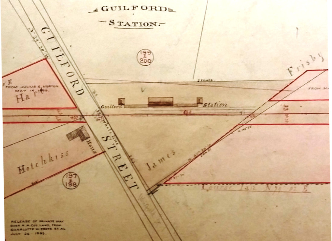
New Haven Museum
|
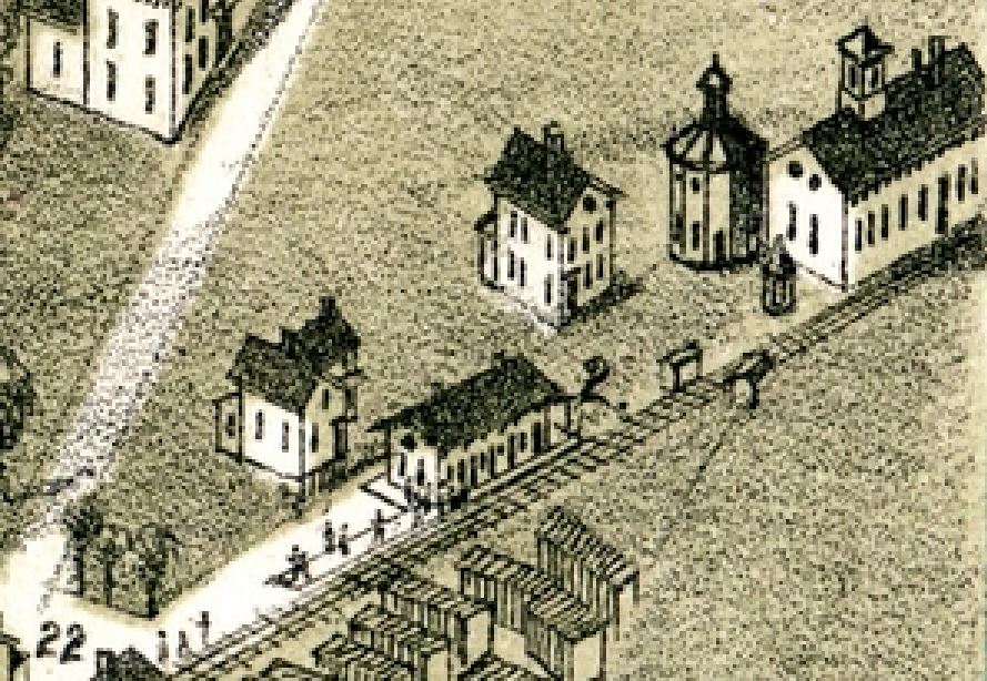
|
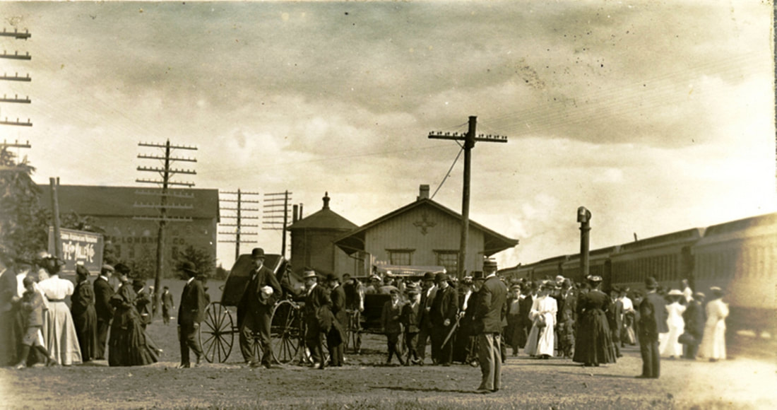
Guilford Free Library
|
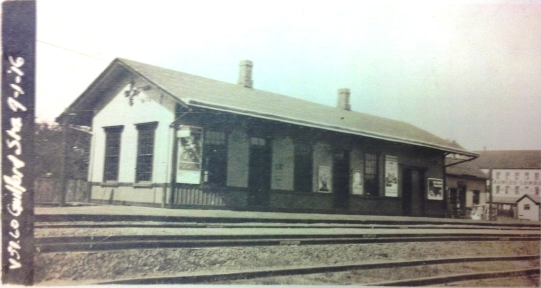
National Archives
|

Richard A. Fleischer Collection
|
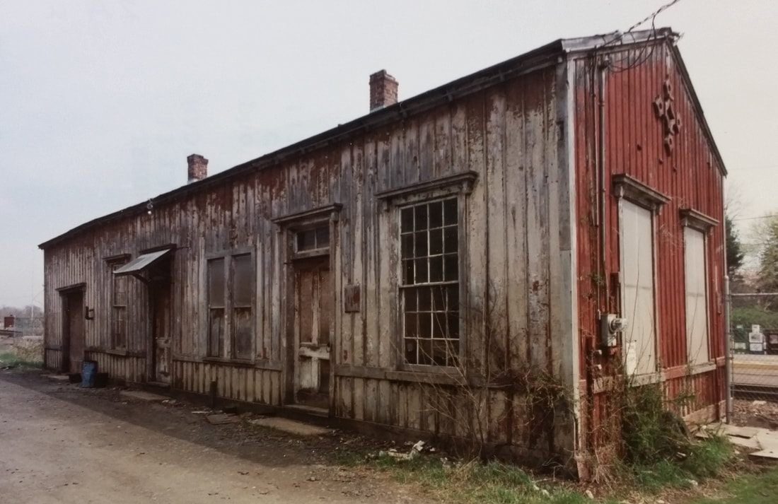
Guilford Free Library
|
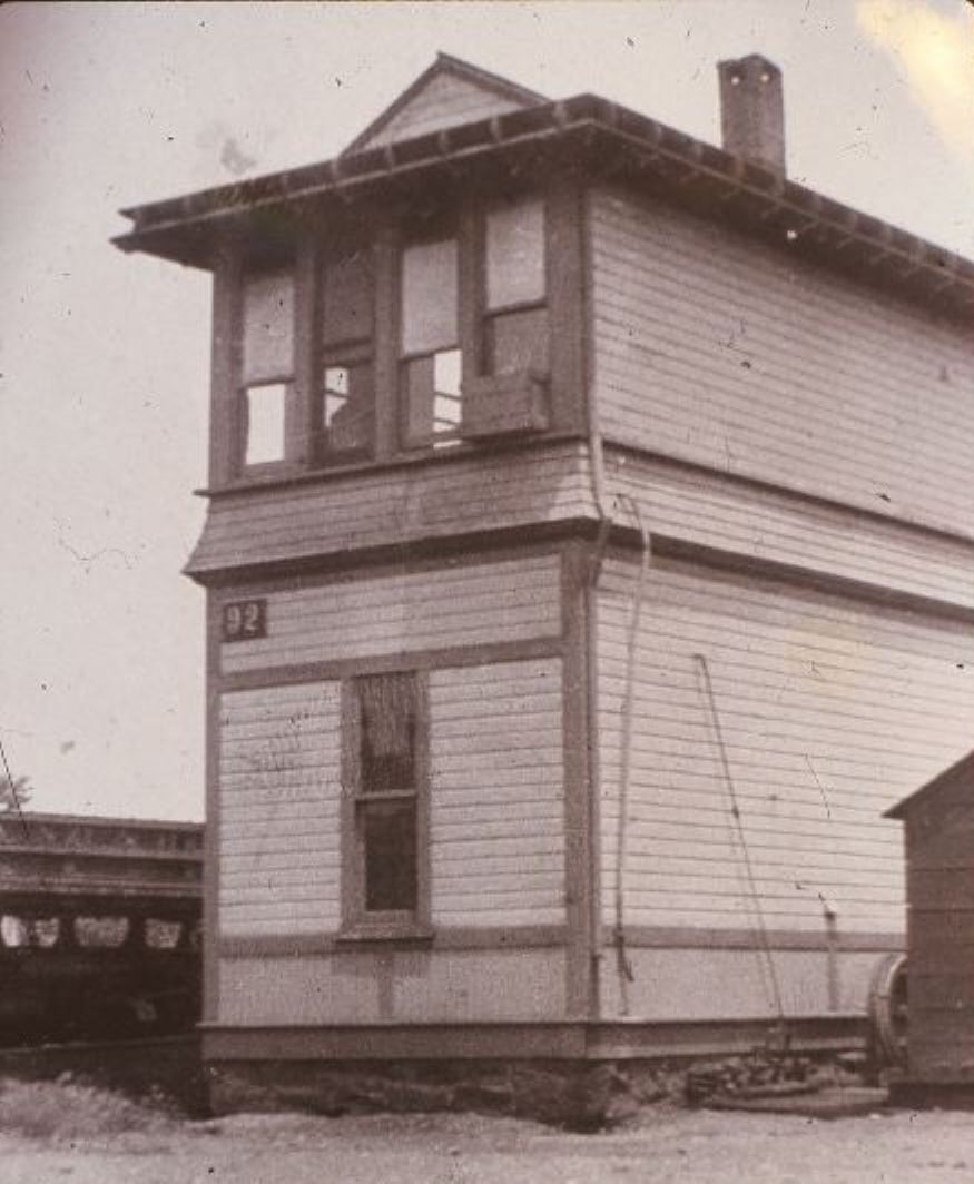
GUILFORD1 [NH&NL, 1852]
The earliest representation of this combination station is on the 1852 NH&NL map seen at [1]. The first visual image that we have seen is from the 1881 Bailey bird's-eye map at [2]; note the octagonal water tank adjacent to the engine house. The shot at [3] shows the Second Platoon, Battery A boys about to depart for Niantic military exercises in the 1890s. The ICC valuation shot at [4] is dated 9/1/1916. Lewis H. Benton's photo #2828 at [5], taken in 1931, shows fellow photographer Irving Drake standing on the platform with arms akimbo and his sedan, frequently with the door open to perhaps indicate some kind of haste, at the left. Also shown is the 1875 water tank and engine house beyond the depot; across the track is the 1910 freight house and the 1892 SS-92 tower in the distance. A 1928 view of the tower is seen at [7]. The image at [6] shows the shows the street side of the derelict station after the fall, 1979 Amtrak removal of the overhangs "... that gave the station its character... emasculating the structure for the remainder of its two decade, give or take, life," quoting local resident and former New Haven employee Paul Beattie. On 1/1/1969 Penn Central absorbed the operations of the NYNH&H and took possession of GUILFORD1 and its furnishings, assessing the cash value at $11,000. With no ticket or baggage service, it was open as a waiting room only from the fall, 1960 NYNH&H timetable to the 1/28/1972 end of PC's Clamdigger. The depot was then leased to the Johnson family for a marine supply and repair business. Amtrak became the owner of most of the Northeast Corridor and the properties therein on 4/1/1976. Utilized from the 1980s as an employee crew base, GUILFORD1 was taken down by Amtrak on 2/23/2000 without notice to the preservationists and town officials who were working on a plan to restore it. In answer to public outcry, Amtrak said that the building was "leaning toward the tracks... ready to collapse," and that they "always try to preserve these things." That the station was part of an NRHP historical district since 1976 shows that such protection is not ironclad. The distinctive 'compass' detail on the passenger station, a NYP&B embellishment from the period of its control of the NH&NL from 1858 to 1862, was still in place until the ignominious end. Interestingly, there was a plan in 1910 to replace "the deplorable and despicable facilities" of GUILFORD1, which some derisively said looked like it was built in 1639 along with the oldest historical home in town! The anticipated new depot was reported to be a duplicate of the brick and stucco ROWAYTON4. With nothing except the sprucing up of the old station done by 1913, the paper said the railroad should not waste its money since despairing passengers were now using Shore Line Electric Railway trolleys for most of their local travel. Even the arrival of a new NYNH&H president Howard Elliott, with some family connections to the town, was not enough to bring the replacement of GUILFORD1, the oldest NH&NL structure in use on the Shore Line for many years. [REFS: MDC/09/17/1874/02; CRC22 .1875.9; NLD/09/21/1892/05; SLT/04/07/1910/05; SLT/10/15/1910/04; HC/07/28/1913 /15; SLT/05/20/1971/03; SLT/05/25/1972/01; SLT/06/08/1972/42G; MRJ/02/26/2000/00: incorrectly says passenger service ended in 1950][rev042119, 062322]
The earliest representation of this combination station is on the 1852 NH&NL map seen at [1]. The first visual image that we have seen is from the 1881 Bailey bird's-eye map at [2]; note the octagonal water tank adjacent to the engine house. The shot at [3] shows the Second Platoon, Battery A boys about to depart for Niantic military exercises in the 1890s. The ICC valuation shot at [4] is dated 9/1/1916. Lewis H. Benton's photo #2828 at [5], taken in 1931, shows fellow photographer Irving Drake standing on the platform with arms akimbo and his sedan, frequently with the door open to perhaps indicate some kind of haste, at the left. Also shown is the 1875 water tank and engine house beyond the depot; across the track is the 1910 freight house and the 1892 SS-92 tower in the distance. A 1928 view of the tower is seen at [7]. The image at [6] shows the shows the street side of the derelict station after the fall, 1979 Amtrak removal of the overhangs "... that gave the station its character... emasculating the structure for the remainder of its two decade, give or take, life," quoting local resident and former New Haven employee Paul Beattie. On 1/1/1969 Penn Central absorbed the operations of the NYNH&H and took possession of GUILFORD1 and its furnishings, assessing the cash value at $11,000. With no ticket or baggage service, it was open as a waiting room only from the fall, 1960 NYNH&H timetable to the 1/28/1972 end of PC's Clamdigger. The depot was then leased to the Johnson family for a marine supply and repair business. Amtrak became the owner of most of the Northeast Corridor and the properties therein on 4/1/1976. Utilized from the 1980s as an employee crew base, GUILFORD1 was taken down by Amtrak on 2/23/2000 without notice to the preservationists and town officials who were working on a plan to restore it. In answer to public outcry, Amtrak said that the building was "leaning toward the tracks... ready to collapse," and that they "always try to preserve these things." That the station was part of an NRHP historical district since 1976 shows that such protection is not ironclad. The distinctive 'compass' detail on the passenger station, a NYP&B embellishment from the period of its control of the NH&NL from 1858 to 1862, was still in place until the ignominious end. Interestingly, there was a plan in 1910 to replace "the deplorable and despicable facilities" of GUILFORD1, which some derisively said looked like it was built in 1639 along with the oldest historical home in town! The anticipated new depot was reported to be a duplicate of the brick and stucco ROWAYTON4. With nothing except the sprucing up of the old station done by 1913, the paper said the railroad should not waste its money since despairing passengers were now using Shore Line Electric Railway trolleys for most of their local travel. Even the arrival of a new NYNH&H president Howard Elliott, with some family connections to the town, was not enough to bring the replacement of GUILFORD1, the oldest NH&NL structure in use on the Shore Line for many years. [REFS: MDC/09/17/1874/02; CRC22 .1875.9; NLD/09/21/1892/05; SLT/04/07/1910/05; SLT/10/15/1910/04; HC/07/28/1913 /15; SLT/05/20/1971/03; SLT/05/25/1972/01; SLT/06/08/1972/42G; MRJ/02/26/2000/00: incorrectly says passenger service ended in 1950][rev042119, 062322]

Guilford Free Library
|
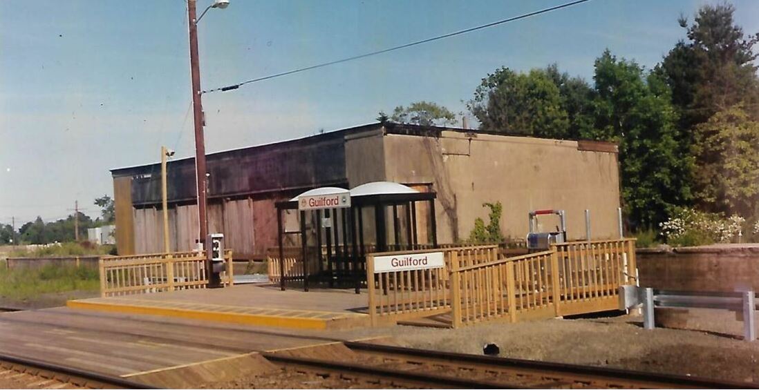
Paul Beattie photo
|
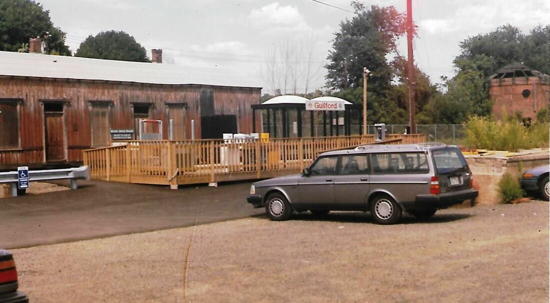
Paul Beattie photo
|
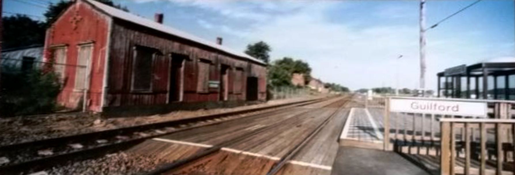
GUILFORD2 [SLE, 1990]
Shore Line East began operations on 5/29/1990 and accommodated passengers with a platform and plexiglass shelters on the south side of the tracks. The photo at [1] is a shot of the forlorn GUILFORD1 from the new GUILFORD2. Paul Beattie's 6/17/1990 photo at [2] shows GUILFORD2 and, behind it, the freight house that would be gone the next year. Paul's 8/31/1990 shot at [3] looks from the freight house site, concrete foundation all that remains at the right. The 1990s view at [4] looks east. Amtrak had taken over the nation's passenger service on 5/1/1971 and PC ran the Clamdigger for ATK until 1/28/1972. Service was restored from 9/9/1976 to 10/30/1977 and again from 1/8/1978 to 4/30/1978 when the Clamdigger was superseded by the Beacon Hill which lasted until 1981. Neither of these later trains stopped at Guilford which had no passenger service for almost 20 years until the debut of SLE in 1990. [REFS: HC/03/27/1973/13; SLT/12/28/1989/00; Wikipedia, "Clamdigger"][rev042119, 062322]
Shore Line East began operations on 5/29/1990 and accommodated passengers with a platform and plexiglass shelters on the south side of the tracks. The photo at [1] is a shot of the forlorn GUILFORD1 from the new GUILFORD2. Paul Beattie's 6/17/1990 photo at [2] shows GUILFORD2 and, behind it, the freight house that would be gone the next year. Paul's 8/31/1990 shot at [3] looks from the freight house site, concrete foundation all that remains at the right. The 1990s view at [4] looks east. Amtrak had taken over the nation's passenger service on 5/1/1971 and PC ran the Clamdigger for ATK until 1/28/1972. Service was restored from 9/9/1976 to 10/30/1977 and again from 1/8/1978 to 4/30/1978 when the Clamdigger was superseded by the Beacon Hill which lasted until 1981. Neither of these later trains stopped at Guilford which had no passenger service for almost 20 years until the debut of SLE in 1990. [REFS: HC/03/27/1973/13; SLT/12/28/1989/00; Wikipedia, "Clamdigger"][rev042119, 062322]
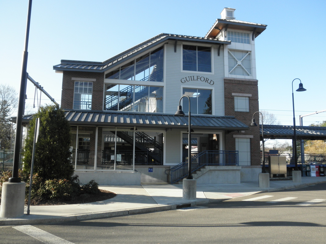
|
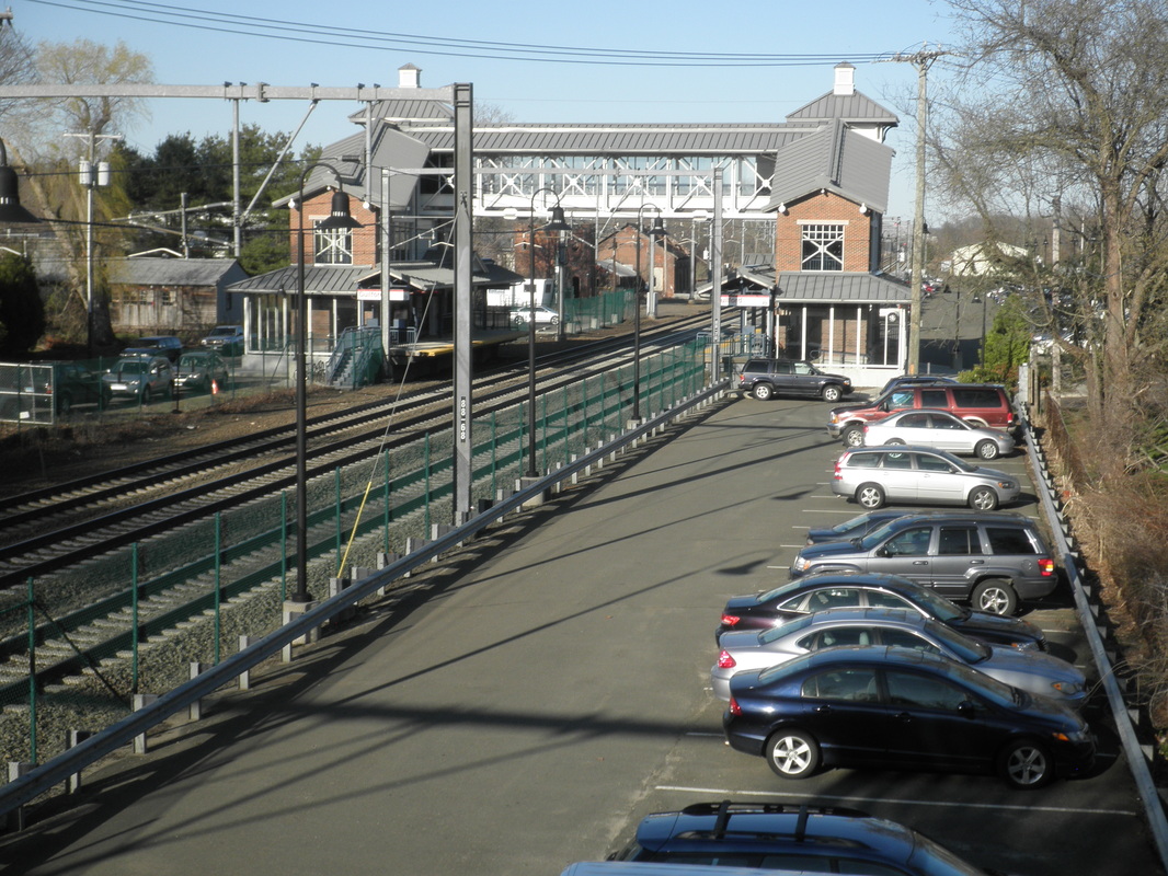
|
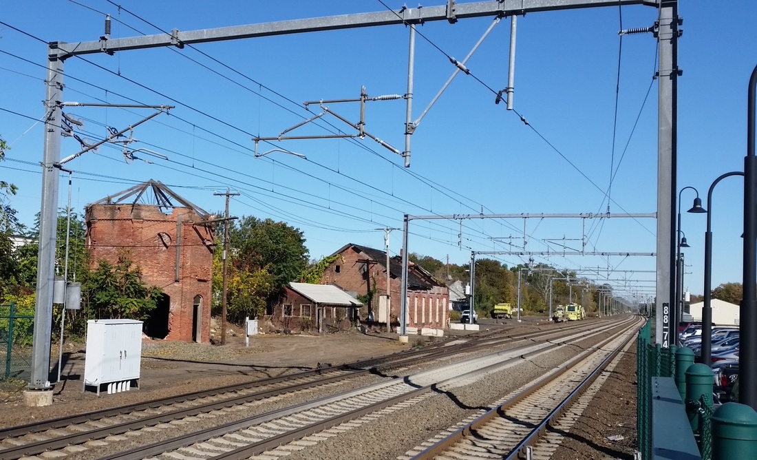
|
GUILFORD3 [SLE, 2005]
This station opened on 11/28/2005 with overhead pedestrian walkway for access to both tracks. In part due to Amtrak's unilateral destruction of GUILFORD1, the town was allowed this more elaborate station facility, which has since become common at SLE stops. The view at [1] looks south, [2] looks east and [3], also eastward, shows the derelict 1875 water tank and engine house, both of which the Guilford Preservation Alliance is trying to save. The brick-enclosed water tank is the last remaining of its type that we know of in the state and perhaps beyond. [rev110414, 041919]
This station opened on 11/28/2005 with overhead pedestrian walkway for access to both tracks. In part due to Amtrak's unilateral destruction of GUILFORD1, the town was allowed this more elaborate station facility, which has since become common at SLE stops. The view at [1] looks south, [2] looks east and [3], also eastward, shows the derelict 1875 water tank and engine house, both of which the Guilford Preservation Alliance is trying to save. The brick-enclosed water tank is the last remaining of its type that we know of in the state and perhaps beyond. [rev110414, 041919]