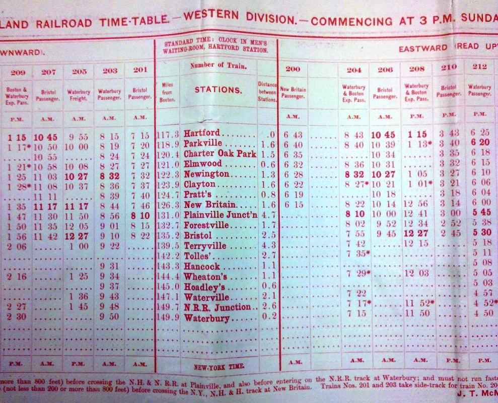
Track 12: CT Passenger Stations, W-WE
See TCS Home Page links for notes, abbreviations, and sources.
Use Track 11 map link to locate stations, rail and trolley lines, and POIs.
Use Track 11 map link to locate stations, rail and trolley lines, and POIs.
WALDO [> SCOTLAND]
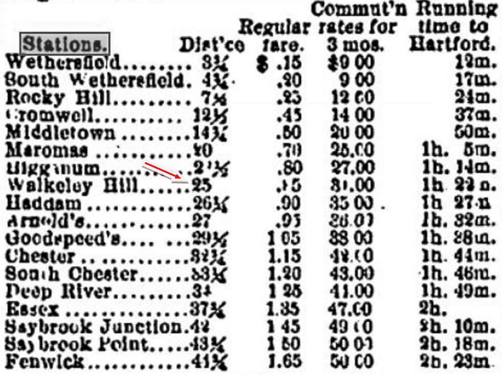
WALKLEY HILL [CV, 1871]
At a distance of 23 miles from Hartford, this was established as a flag stop in 1871 between HIGGANUM and HADDAM in the town of the latter name. Down the hill from the home of the first CV president, James C. Walkley, and thought by some to be his private station, it was used by the public as well, at times heavily. The station agent also handled steamboat dockings at Rock Landing on the east side of the Connecticut River and sold tickets there to passengers wishing to board at WALKLEY HILL. An October, 1872 newspaper article said agent George E. Russell had sold 407 tickets since June 8. Reportedly, these riders had to provide their own passage across the river! This depot had the only locomotive water column between Middletown and Old Saybrook. Middletown's Penny Press newspaper tells us WALKLEY HILL station burned in 1887 [MM] and no photos have been found yet. [REFS:; HDC/10/26/1872/04; DC/10/23/1872; HDC/04/23/1873/02; RRC8.438 (1874); PP/11/07/1887/04][rev050113]
At a distance of 23 miles from Hartford, this was established as a flag stop in 1871 between HIGGANUM and HADDAM in the town of the latter name. Down the hill from the home of the first CV president, James C. Walkley, and thought by some to be his private station, it was used by the public as well, at times heavily. The station agent also handled steamboat dockings at Rock Landing on the east side of the Connecticut River and sold tickets there to passengers wishing to board at WALKLEY HILL. An October, 1872 newspaper article said agent George E. Russell had sold 407 tickets since June 8. Reportedly, these riders had to provide their own passage across the river! This depot had the only locomotive water column between Middletown and Old Saybrook. Middletown's Penny Press newspaper tells us WALKLEY HILL station burned in 1887 [MM] and no photos have been found yet. [REFS:; HDC/10/26/1872/04; DC/10/23/1872; HDC/04/23/1873/02; RRC8.438 (1874); PP/11/07/1887/04][rev050113]

WALLINGFORD1 [H&NH, 1838]
According to Dave Peters, the residence seen on the left served as the first station in town at the foot of Center St. along the single-tracked H&NH. This is an 1852 inset added to the Bailey bird's-eye map of 1905. The scene looks east, with the churches on Main St. in the distance. [REFS: R1.349]
According to Dave Peters, the residence seen on the left served as the first station in town at the foot of Center St. along the single-tracked H&NH. This is an 1852 inset added to the Bailey bird's-eye map of 1905. The scene looks east, with the churches on Main St. in the distance. [REFS: R1.349]
|
|
|
WALLINGFORD2 [H&NH, 1848]
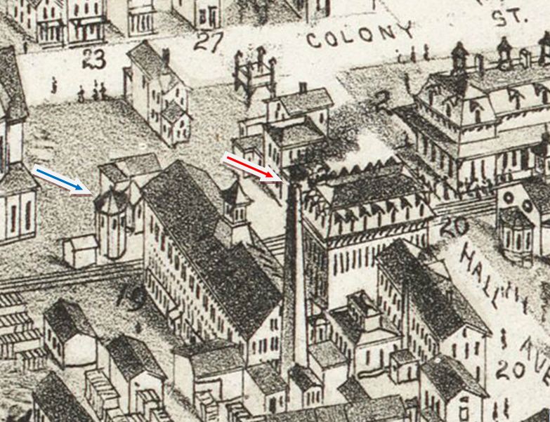
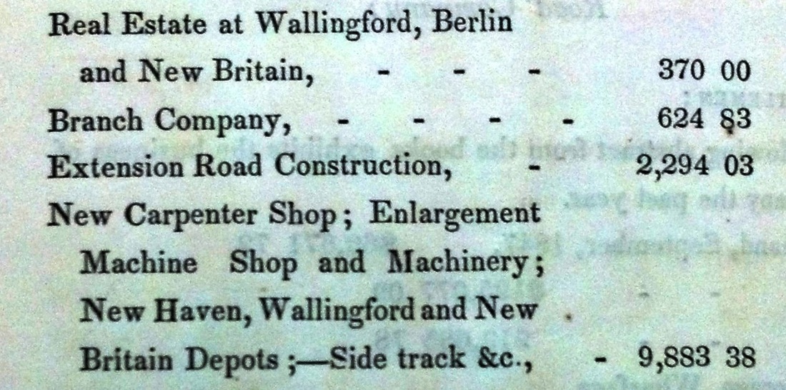
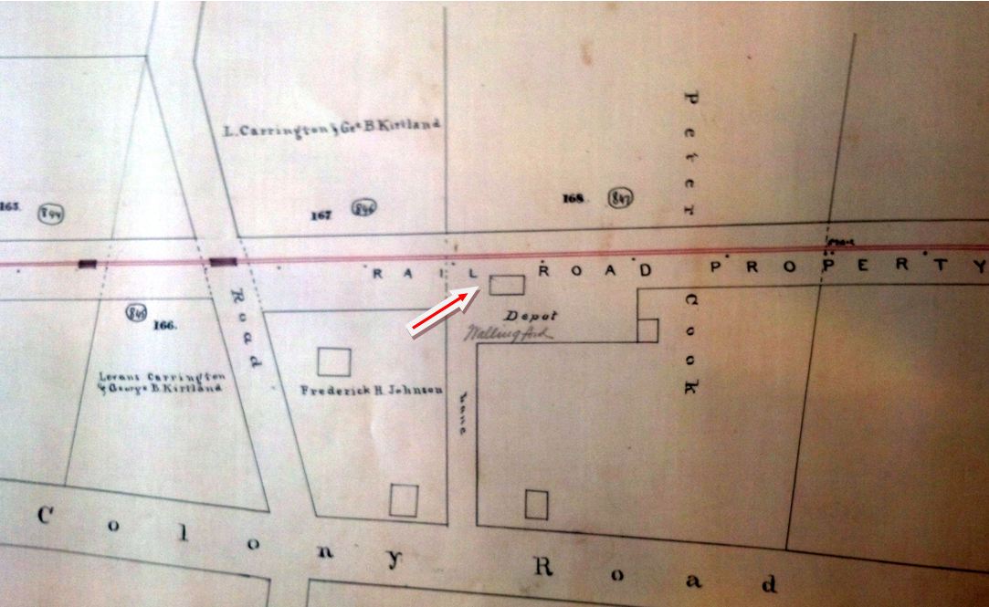
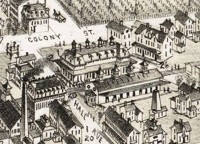
The image at [1] is from the Bailey bird's-eye map of 1881. Two 1870 Register articles from the same day and page say that the station is opposite the Wallingford Wheel Co. and the Hall, Elton & Co., which are seen at locator numbers 19 and 20 on the map. The entire lot east of the track may have been railroad property with our blue arrow pointing to a switch shed and the red arrow possibly indicating the station with a low-roofed trackside canopy. What relationship this structure bore to the previous station, other than the almost exact location, is unclear but the snippet at [2] from the 1848 annual report says that real estate was purchased and a station was built in that year. Additional testimony comes from R&LHS notes that say a Springfield contractor by the name of Smith made a 4/3/1848 offer to construct a depot at Wallingford for $1,805, as well as a station at Berlin for $1760, or $3550 for both. We are inclined to think that this Mansard-roofed building, though it looks nothing like BERLIN2, and possibly the adjacent switch shed were both Smith's work, The map at [3] is from an atlas dated 1872 but shows the locale in earlier time, with the depot in a location seems to correspond to the Bailey map. Assuming we are correct, this is the depot that would serve until the next one was built in 1871. There were calls for a new station already by 1870 when a rather mysterious robbery occurred. The Register remarked that "... if the thief had taken the rickety old depot on his back and walked off, the people would have rejoiced over the event, but to creep through a window and steal about $50 of the company's money, is another matter..." The "stout looking man, poorly clad" was reportedly spied in the vicinity and seen later in Yalesville where he "took the cars for the north." One late improvement that was noted here was the installation of Hall's electric signals wherein "the bell rings promptly when the approaching train is within a half a mile of the station." [REFS: HNHAR13.1848.14; CR/05/28/1870/02a; CR/05/28/1870/02b; CR/10/08/1870/02; CR/09/24/1870/04; CR/10/08/1870/02; HDC/10/20/1870/04; CR/11/05/ 1870/02; B621][rev 112018]
The image at [1] is from the Bailey bird's-eye map of 1881. Two 1870 Register articles from the same day and page say that the station is opposite the Wallingford Wheel Co. and the Hall, Elton & Co., which are seen at locator numbers 19 and 20 on the map. The entire lot east of the track may have been railroad property with our blue arrow pointing to a switch shed and the red arrow possibly indicating the station with a low-roofed trackside canopy. What relationship this structure bore to the previous station, other than the almost exact location, is unclear but the snippet at [2] from the 1848 annual report says that real estate was purchased and a station was built in that year. Additional testimony comes from R&LHS notes that say a Springfield contractor by the name of Smith made a 4/3/1848 offer to construct a depot at Wallingford for $1,805, as well as a station at Berlin for $1760, or $3550 for both. We are inclined to think that this Mansard-roofed building, though it looks nothing like BERLIN2, and possibly the adjacent switch shed were both Smith's work, The map at [3] is from an atlas dated 1872 but shows the locale in earlier time, with the depot in a location seems to correspond to the Bailey map. Assuming we are correct, this is the depot that would serve until the next one was built in 1871. There were calls for a new station already by 1870 when a rather mysterious robbery occurred. The Register remarked that "... if the thief had taken the rickety old depot on his back and walked off, the people would have rejoiced over the event, but to creep through a window and steal about $50 of the company's money, is another matter..." The "stout looking man, poorly clad" was reportedly spied in the vicinity and seen later in Yalesville where he "took the cars for the north." One late improvement that was noted here was the installation of Hall's electric signals wherein "the bell rings promptly when the approaching train is within a half a mile of the station." [REFS: HNHAR13.1848.14; CR/05/28/1870/02a; CR/05/28/1870/02b; CR/10/08/1870/02; CR/09/24/1870/04; CR/10/08/1870/02; HDC/10/20/1870/04; CR/11/05/ 1870/02; B621][rev 112018]
|

|

|
WALLINGFORD3 [H&NH, 1871]
A newspaper article indicates that activity commenced in February, 1871 on this long-awaited station when it reported that "Superintendent Reed has staked off the ground for a new depot at Wallingford" and later in the month: "A special train with a corps of laborers arrived... and the men were soon at work excavating for the foundation of the new depot. The work was commenced with the characteristic precision of every movement in connection with the road. The picks, bars, and wedges soon made their way through some twenty inches of frozen ground, and before night enough ground was removed to show that the work was commenced in earnest." Mr. C.A. Dickerman of New Haven got the contract for the depot buildings and by August it was "under cover." The "large and handsome structure, built of brick, and arranged in a tasty and convenient manner" opened to the public on 11/4/1871. The image at left is also from the bird's-eye map of 1881 and highlights the striking image of this station and the matching freight house that was built shortly afterward across the tracks. Saved through the valiant and persistent efforts of Dave Peters, WALLINGFORD3 was renovated and restored to its original grandeur and serves today as a community center. It received an NRHP designation in 1993. Rail service ended for this structure on 4/25/2016 when a temporary platform was set up until WALLINGFORD4 could be opened. [REFS: HDC/11/30/1870/02; NA/02/08/1871/03; CR/02/11/1871/02; CR/02/25/1871/02; HDC/03/07/1871/02; CR/04/29/1871/02; BDA/08/09/1871/04; HDC/11/07/1871/04; R101][rev112018, 043022]
A newspaper article indicates that activity commenced in February, 1871 on this long-awaited station when it reported that "Superintendent Reed has staked off the ground for a new depot at Wallingford" and later in the month: "A special train with a corps of laborers arrived... and the men were soon at work excavating for the foundation of the new depot. The work was commenced with the characteristic precision of every movement in connection with the road. The picks, bars, and wedges soon made their way through some twenty inches of frozen ground, and before night enough ground was removed to show that the work was commenced in earnest." Mr. C.A. Dickerman of New Haven got the contract for the depot buildings and by August it was "under cover." The "large and handsome structure, built of brick, and arranged in a tasty and convenient manner" opened to the public on 11/4/1871. The image at left is also from the bird's-eye map of 1881 and highlights the striking image of this station and the matching freight house that was built shortly afterward across the tracks. Saved through the valiant and persistent efforts of Dave Peters, WALLINGFORD3 was renovated and restored to its original grandeur and serves today as a community center. It received an NRHP designation in 1993. Rail service ended for this structure on 4/25/2016 when a temporary platform was set up until WALLINGFORD4 could be opened. [REFS: HDC/11/30/1870/02; NA/02/08/1871/03; CR/02/11/1871/02; CR/02/25/1871/02; HDC/03/07/1871/02; CR/04/29/1871/02; BDA/08/09/1871/04; HDC/11/07/1871/04; R101][rev112018, 043022]
 Wikipedia
WALLINGFORD4 [CDOT, 2017]
Opened on 11/26/2017 as part of the new double-tracking of the CTrail Springfield Line and station upgrades. [add112018]
Opened on 11/26/2017 as part of the new double-tracking of the CTrail Springfield Line and station upgrades. [add112018]
WALLINGFORD/A1,2 [> EAST WALLINGFORD1,2]
WAPPING [> SOUTH WINDSOR]
WAPPING [> SOUTH WINDSOR]
WAREHOUSE POINT1 [H&NH, 1845]
This was not an original stop in the town of Enfield when the line to Springfield was opened in 1844. In the next year, however, the 1845 H&NH annual report, issued in September, says that "in addition to the present cost of the road, there is in the course of erection a small depot at the east end of the Connecticut River crossing." Apparently too late to be listed on a New Haven, Hartford and Springfield RR 10/1/1845TT, an 1851TT does show it, and the location is seen on this 1855HC map. We have no photo of the first depot that sat, like its successor, on the curve coming off the bridge, presumably on the same, east side of the tracks. Rail from the north was laid to this point in September, 1844. While at least one article suggests that the bridge may not have been finished until late in 1846, the H&NH annual reports say that it was there for the opening of the Springfield extension on 12/9/1844. Apparently one of the seven spans, probably the center, of the wooden bridge was a draw, mandated by the legislature. The 1845 annual report says that this stipulation, "for which no use has yet been discovered"(!) was one reason the construction cost of the line exceeded estimates. Interestingly, this station is named for the community to the south in the town of East Windsor, but this stop, well north of the border, was in the town of Enfield. Warehouse Point as a shipping locale dates back to Colonial times since navigation above the adjacent Enfield Falls was only possible with the building of the west-bank canal for which Windsor Locks was named. A canal on the east side of the river was also considered, even after the railroad opened and dominated freight traffic here, but never came to fruition. An interesting note about this locale is mentioned in 1867 when the Second Adventists gathered here for their annual camp meeting "beginning on the first of July, when all expect to be taken up." The sect believed that the second coming of Christ was imminent and that the world would end at that time and the true believers would ascend with him into the sky. Accommodations were being made for 6,000 people, many of whom undoubtedly came by train to WAREHOUSE POINT1. Their campground grove was said to be about 100 yards east of the depot, where "the screech of the iron horse, which passes here almost hourly, interferes in some degree with the pious efforts..." The meeting lasted for three days and all went home without the divine happenings that were expected. [REFS: NHM44 (05/24/1844); MC/09/11/1844/02; HNHAR10.1845.4; NYH/07/07/1867/03][rev082013, 102020]
This was not an original stop in the town of Enfield when the line to Springfield was opened in 1844. In the next year, however, the 1845 H&NH annual report, issued in September, says that "in addition to the present cost of the road, there is in the course of erection a small depot at the east end of the Connecticut River crossing." Apparently too late to be listed on a New Haven, Hartford and Springfield RR 10/1/1845TT, an 1851TT does show it, and the location is seen on this 1855HC map. We have no photo of the first depot that sat, like its successor, on the curve coming off the bridge, presumably on the same, east side of the tracks. Rail from the north was laid to this point in September, 1844. While at least one article suggests that the bridge may not have been finished until late in 1846, the H&NH annual reports say that it was there for the opening of the Springfield extension on 12/9/1844. Apparently one of the seven spans, probably the center, of the wooden bridge was a draw, mandated by the legislature. The 1845 annual report says that this stipulation, "for which no use has yet been discovered"(!) was one reason the construction cost of the line exceeded estimates. Interestingly, this station is named for the community to the south in the town of East Windsor, but this stop, well north of the border, was in the town of Enfield. Warehouse Point as a shipping locale dates back to Colonial times since navigation above the adjacent Enfield Falls was only possible with the building of the west-bank canal for which Windsor Locks was named. A canal on the east side of the river was also considered, even after the railroad opened and dominated freight traffic here, but never came to fruition. An interesting note about this locale is mentioned in 1867 when the Second Adventists gathered here for their annual camp meeting "beginning on the first of July, when all expect to be taken up." The sect believed that the second coming of Christ was imminent and that the world would end at that time and the true believers would ascend with him into the sky. Accommodations were being made for 6,000 people, many of whom undoubtedly came by train to WAREHOUSE POINT1. Their campground grove was said to be about 100 yards east of the depot, where "the screech of the iron horse, which passes here almost hourly, interferes in some degree with the pious efforts..." The meeting lasted for three days and all went home without the divine happenings that were expected. [REFS: NHM44 (05/24/1844); MC/09/11/1844/02; HNHAR10.1845.4; NYH/07/07/1867/03][rev082013, 102020]

Richard A. Fleischer Collection
|

|
Edward J. Ozog Collection
|

|
|
|

WAREHOUSE POINT2 [H&NH, 1870]
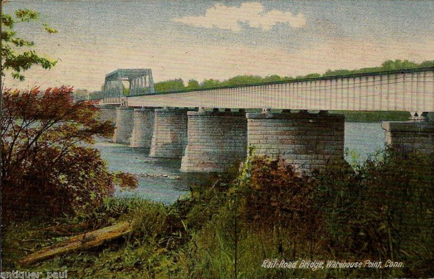
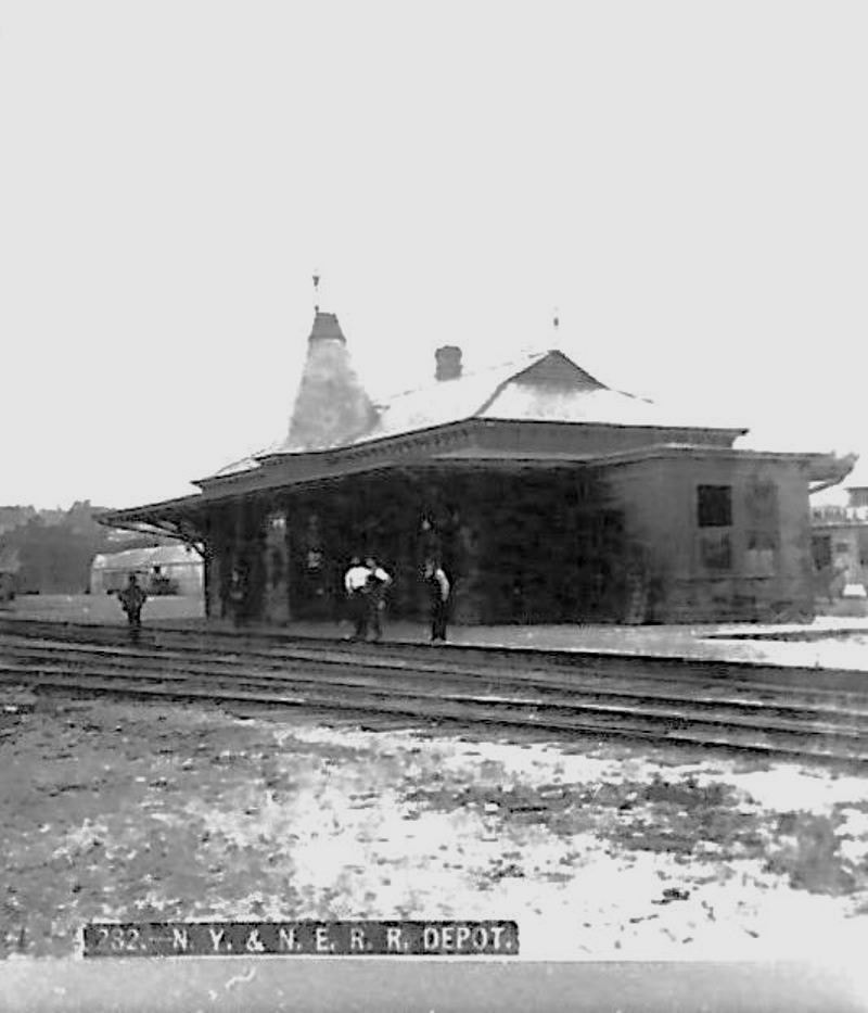
A Courant article late in 1869 says that "On Friday Charlie lord (sic) of Windsor Locks, while at work upon the new depot in Warehouse point (sic), lost his footing and slid from the ridge to the caves, a distance of twenty feet, and then fell to the ground, some 30 feet. He got up, lighted his pipe, and took a smoke in commemoration of the event. No bones were broken, but he thinks he would have preferred coming down the ladder, and will try to do so the next time." We are happy that Charlie emerged unscathed from this tumble, the report of which is the only reference in any source yet found to when this this stately brick structure was erected. This information corrects Michael C. DeVito's claim that this depot was built in 1872. The photo at [1] was taken in June of 1929 by Lewis H. Benton, his #2358. The southward-looking shot at [2] is captioned by his fellow photographer and 'chauffeur' Irving N. Drake, likely taken on the same day. Elegant is another word that can be used to describe this beautiful structure. The elaborate wood-carved brackets for the porch covering on the street-side view at [3] are worthy of an affluent homeowner. DeVito says plausibly that the passenger station was heavily damaged in the 1938 hurricane and taken down the next year. NYNH&H real estate records, in fact, give a sale date of 8/12/1939 for the depot listed as structure #5957. Perhaps it was sold to a contractor who demolished it for scrap value. The 1910 real estate map at [4] shows the layout at that time and the piers for the bridge that lead almost right up to the station. The first bridge was blown down in a gale on 10/13/1846 and rebuilt within six weeks. The photo at [5] shows the second bridge, a single-track iron structure built in 1865, and the view at [6] shows the double-tracked third bridge that was put into operation on 6/5/1905 and still serves today. The freight house, still standing in 2013, is shown in the distance in the photo at [7] .On the 1938 SSRR it was mentioned that the second floor was rented at that time. The 7/19/1940 SSRR addendum gives the sale date of 8/12/1939. [REFS: NLMN/10/15/1846/02; MC/11/25/1846/02; HNHAR12.1847.6; NA/04/01/1865/03; AEJ/06/25/1867/02; HDC/11/09/1869/02; NHAR34.1905.06; DeVito, Hartford & Springfield Street Railway Co, p14; R102][rev010518, 102020]
A Courant article late in 1869 says that "On Friday Charlie lord (sic) of Windsor Locks, while at work upon the new depot in Warehouse point (sic), lost his footing and slid from the ridge to the caves, a distance of twenty feet, and then fell to the ground, some 30 feet. He got up, lighted his pipe, and took a smoke in commemoration of the event. No bones were broken, but he thinks he would have preferred coming down the ladder, and will try to do so the next time." We are happy that Charlie emerged unscathed from this tumble, the report of which is the only reference in any source yet found to when this this stately brick structure was erected. This information corrects Michael C. DeVito's claim that this depot was built in 1872. The photo at [1] was taken in June of 1929 by Lewis H. Benton, his #2358. The southward-looking shot at [2] is captioned by his fellow photographer and 'chauffeur' Irving N. Drake, likely taken on the same day. Elegant is another word that can be used to describe this beautiful structure. The elaborate wood-carved brackets for the porch covering on the street-side view at [3] are worthy of an affluent homeowner. DeVito says plausibly that the passenger station was heavily damaged in the 1938 hurricane and taken down the next year. NYNH&H real estate records, in fact, give a sale date of 8/12/1939 for the depot listed as structure #5957. Perhaps it was sold to a contractor who demolished it for scrap value. The 1910 real estate map at [4] shows the layout at that time and the piers for the bridge that lead almost right up to the station. The first bridge was blown down in a gale on 10/13/1846 and rebuilt within six weeks. The photo at [5] shows the second bridge, a single-track iron structure built in 1865, and the view at [6] shows the double-tracked third bridge that was put into operation on 6/5/1905 and still serves today. The freight house, still standing in 2013, is shown in the distance in the photo at [7] .On the 1938 SSRR it was mentioned that the second floor was rented at that time. The 7/19/1940 SSRR addendum gives the sale date of 8/12/1939. [REFS: NLMN/10/15/1846/02; MC/11/25/1846/02; HNHAR12.1847.6; NA/04/01/1865/03; AEJ/06/25/1867/02; HDC/11/09/1869/02; NHAR34.1905.06; DeVito, Hartford & Springfield Street Railway Co, p14; R102][rev010518, 102020]
|
|
|

|
WASHINGTON1 [SRR, 1872]
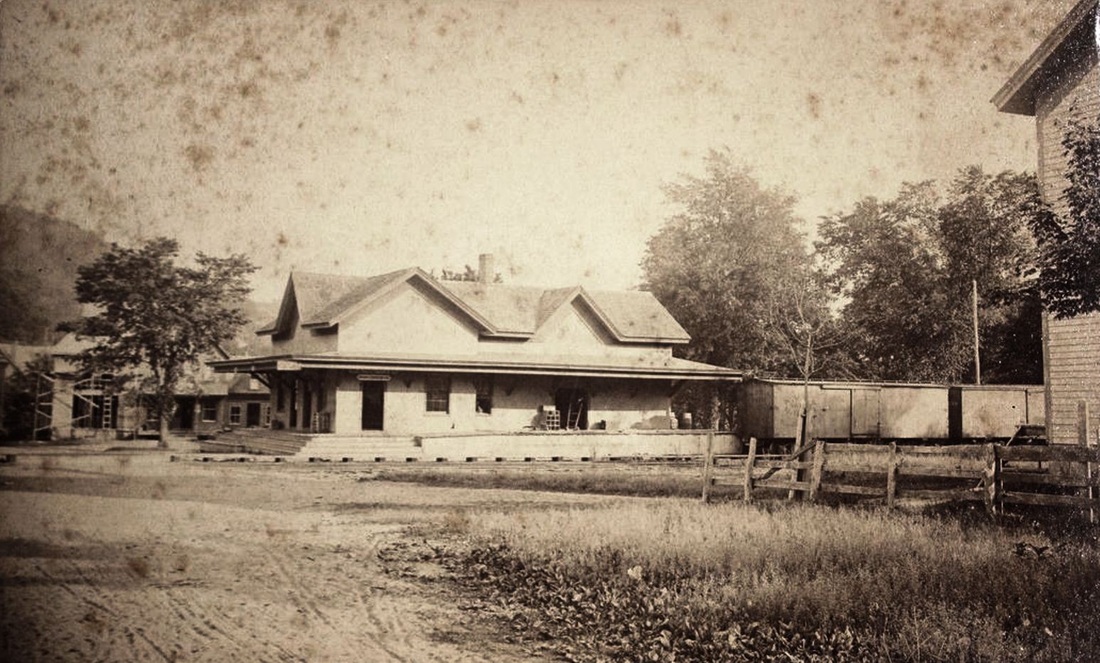
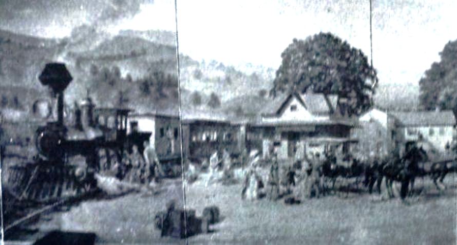
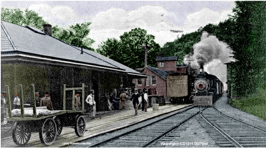
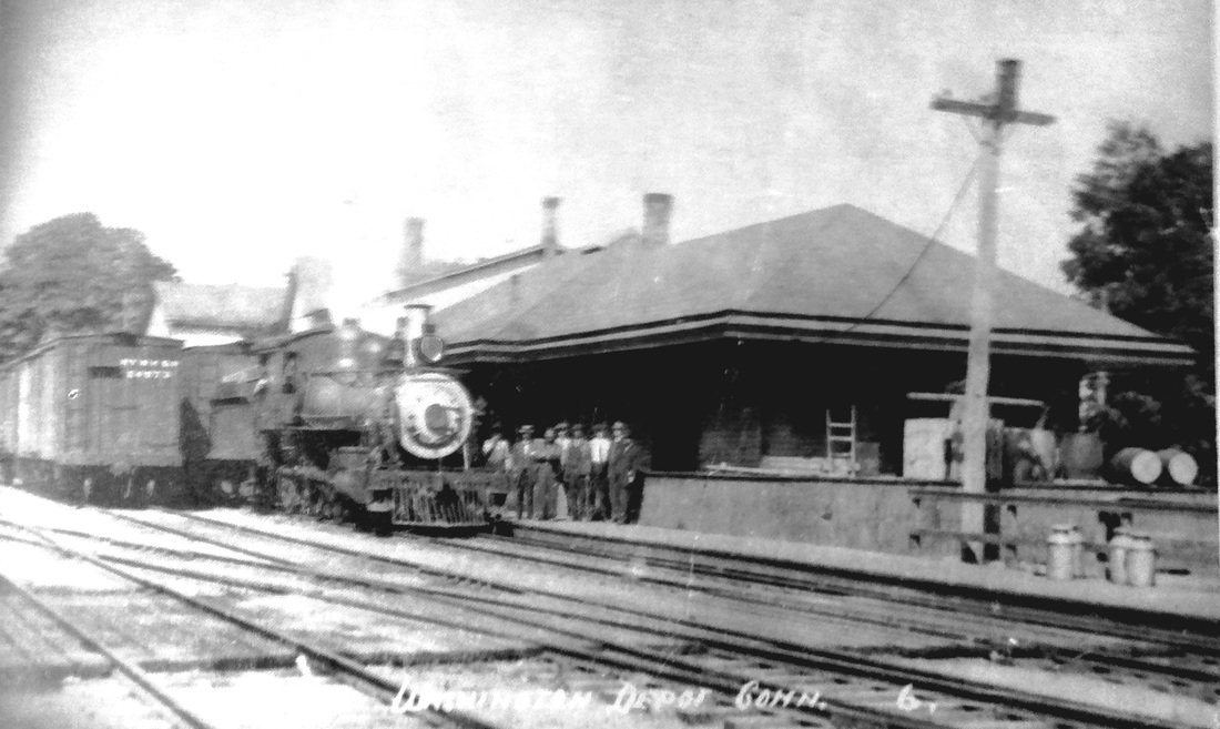
The 1893 image [1], taken by the N.D. Benedict of Washington, shows the first station in this town. The photo at [2], though grainy, also shows this sizeable structure that handled passenger and freight service and perhaps other commercial activity as well. This one-and-a-half-story depot burned on 4/9/1895, fire having spread from the Watts Bros. general store that was struck by lightning. Both buildings were totally destroyed but valuables were rescued from the depot before the flames consumed it. The image at [3] is artist Feodor Rimsky's representation of an 1875 scene at the station. Townspeople reportedly posed in period costume for this multi-paneled mural that is still on display today at the Litchfield Bancorp office in town. The real estate map [4] shows the layout of the depot grounds ca. 1900. [REFS: NHER/04/10/1895/01; D154; R102] [rev031914]
The 1893 image [1], taken by the N.D. Benedict of Washington, shows the first station in this town. The photo at [2], though grainy, also shows this sizeable structure that handled passenger and freight service and perhaps other commercial activity as well. This one-and-a-half-story depot burned on 4/9/1895, fire having spread from the Watts Bros. general store that was struck by lightning. Both buildings were totally destroyed but valuables were rescued from the depot before the flames consumed it. The image at [3] is artist Feodor Rimsky's representation of an 1875 scene at the station. Townspeople reportedly posed in period costume for this multi-paneled mural that is still on display today at the Litchfield Bancorp office in town. The real estate map [4] shows the layout of the depot grounds ca. 1900. [REFS: NHER/04/10/1895/01; D154; R102] [rev031914]
|
|
|
|

|
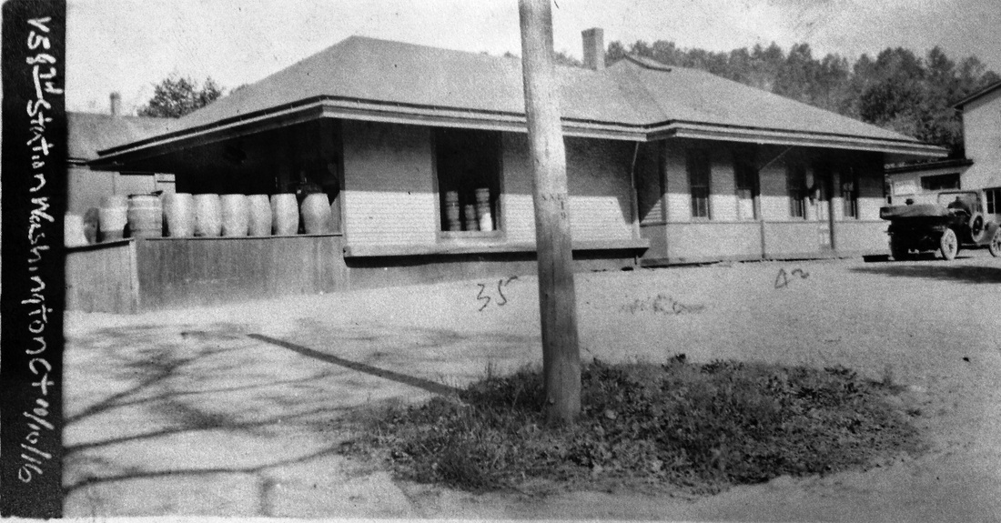
WASHINGTON2 [NYNH&H, 1895]
This was the replacement for the first station. No articles have yet been found about its actual opening. R&LHS notes at the Baker Library show NYNH&H expenses in 1895 of $2888.80 toward the construction of this building but we are not sure that this was the total cost. The image at [1] is an 11/10/1916 val photo showing the street side of the depot. The photo at [4] is from 1949 just after the rails were lifted. Reportedly after the floods of 1955, the NYNH&H sold the building to the town. It was turned 180 degrees and moved across the street where it continues to house American Legion Post 87 and the town senior center. Image [5] is a 2013 views. [REFS: R102][rev030914]
This was the replacement for the first station. No articles have yet been found about its actual opening. R&LHS notes at the Baker Library show NYNH&H expenses in 1895 of $2888.80 toward the construction of this building but we are not sure that this was the total cost. The image at [1] is an 11/10/1916 val photo showing the street side of the depot. The photo at [4] is from 1949 just after the rails were lifted. Reportedly after the floods of 1955, the NYNH&H sold the building to the town. It was turned 180 degrees and moved across the street where it continues to house American Legion Post 87 and the town senior center. Image [5] is a 2013 views. [REFS: R102][rev030914]
|
Max Miller Collection
|
ICC Collection/National Archives
|
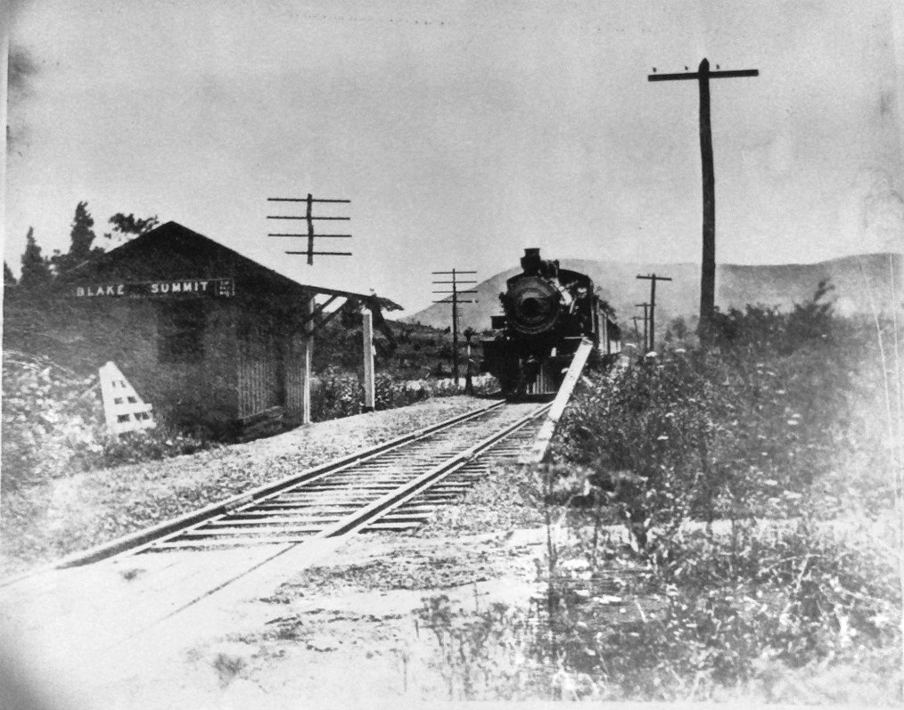
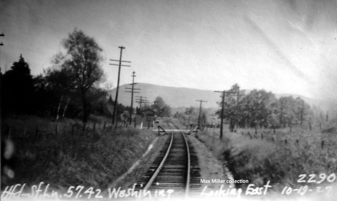
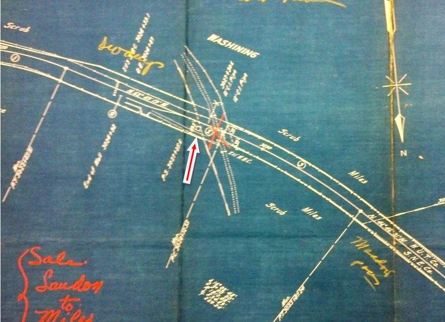
WASHINING [CW, 1872; opened as FOLEYS]
This was the first CW stop west of CANAAN, about a mile east of the TWIN LAKES station in the town of SALISBURY. This probably began as a flag stop named FOLEYS, seen on a 4/2/1872ETT and not thereafter through 1907, though we find it in the GHDs in the intervening years. In 1909, the Courant said that a BLAKES SUMMIT flag stop had been established here and a side track put in for the convenience of Twin Lakes campers on the south and east shores of the upper lake. Even then it does not show up on a CNE 6/5/1910TT but it does appear as BLAKE'S SUMMIT on a 1914TT. By 1916, presumably pursuant to the ICC's 1915 order to rename stations for safety reasons, the stop would become WASHINING, the name of the upper lake. Interestingly, the 'twin lakes' are not physical twins at all, but were named in Native American lore for the Mahican twin maidens, Washinee and Washining. The photo at left presumably shows the structure that the Courant reported was built in 1909 with BLAKE SUMMIT on the signboard. The PUC inspection photo is dated 10/19/1927. Assuming the signboard reads WASHINING, we have a rare occurrence of images showing the same structure with two different station names. The val map at right shows the layout of the crossing in 1916, with the station sitting in the northeast quadrant. We find this stop listed on timetables in the late 1920s and perhaps still used seasonally, but usually with not even an 'f' for a flag stop. [REFS: HC/06/26/09/15; 1882, 1890, 1900, 1903, 1907TTs: no; HC/09/09/1909/11; D42+][rev042013]
This was the first CW stop west of CANAAN, about a mile east of the TWIN LAKES station in the town of SALISBURY. This probably began as a flag stop named FOLEYS, seen on a 4/2/1872ETT and not thereafter through 1907, though we find it in the GHDs in the intervening years. In 1909, the Courant said that a BLAKES SUMMIT flag stop had been established here and a side track put in for the convenience of Twin Lakes campers on the south and east shores of the upper lake. Even then it does not show up on a CNE 6/5/1910TT but it does appear as BLAKE'S SUMMIT on a 1914TT. By 1916, presumably pursuant to the ICC's 1915 order to rename stations for safety reasons, the stop would become WASHINING, the name of the upper lake. Interestingly, the 'twin lakes' are not physical twins at all, but were named in Native American lore for the Mahican twin maidens, Washinee and Washining. The photo at left presumably shows the structure that the Courant reported was built in 1909 with BLAKE SUMMIT on the signboard. The PUC inspection photo is dated 10/19/1927. Assuming the signboard reads WASHINING, we have a rare occurrence of images showing the same structure with two different station names. The val map at right shows the layout of the crossing in 1916, with the station sitting in the northeast quadrant. We find this stop listed on timetables in the late 1920s and perhaps still used seasonally, but usually with not even an 'f' for a flag stop. [REFS: HC/06/26/09/15; 1882, 1890, 1900, 1903, 1907TTs: no; HC/09/09/1909/11; D42+][rev042013]

|

|
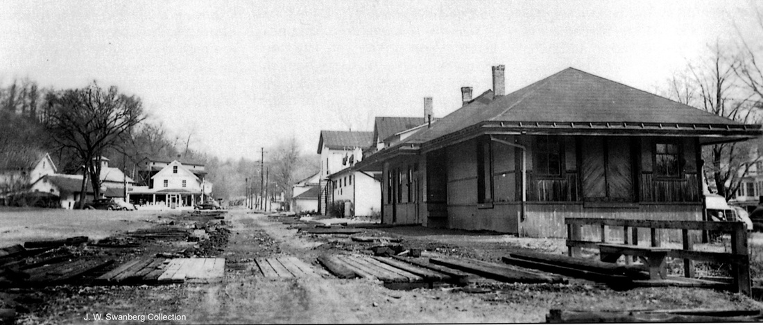
WATERBURY1 [NRR, 1849]
This was "a meager affair" that was built after the station had been in a hotel by the tracks for a period of time. The 1852NH map [left] does not identify the depot at the foot of Bank St. yet but the 1856NH map [OHS] at right shows it, with Bank St. now extended past the track. That would agree with Pape's History of Waterbury and the Naugatuck Valley [1:95] which puts the date for the building of this first station at 1857. More research needs to be done to clarify this. The HP&F opened in 1855 to a junction with the NRR just above the Bank St. station. With no other depot seen, the two roads probably shared Bank St. until the HP&F built WATERBURY2. [REFS: WA/01/03/1908/03]
This was "a meager affair" that was built after the station had been in a hotel by the tracks for a period of time. The 1852NH map [left] does not identify the depot at the foot of Bank St. yet but the 1856NH map [OHS] at right shows it, with Bank St. now extended past the track. That would agree with Pape's History of Waterbury and the Naugatuck Valley [1:95] which puts the date for the building of this first station at 1857. More research needs to be done to clarify this. The HP&F opened in 1855 to a junction with the NRR just above the Bank St. station. With no other depot seen, the two roads probably shared Bank St. until the HP&F built WATERBURY2. [REFS: WA/01/03/1908/03]
|
|
WATERBURY2 [HP&F, c1860?]
We do not know exactly when this HP&F station was built, but it likely came too late to be on the 1856NH map shown in the previous listing. The important photo at left shows WATERBURY2 standing alone at this location, verifying the fact that it was the earlier part of the composite structure seen below as WATERBURY4. Our red arrow points to it in the shot from the 1876 Bailey bird's-eye map at right. This depot was sometimes said to have been on West Main St. but it actually sat at the nearby intersection of Meadow St. and the lower end of Willow St. The train in the map shot is on the NRR track and has just departed the WATERBURY3 station on Bank St. [blue arrow] and is headed for points north. [rev042013]
We do not know exactly when this HP&F station was built, but it likely came too late to be on the 1856NH map shown in the previous listing. The important photo at left shows WATERBURY2 standing alone at this location, verifying the fact that it was the earlier part of the composite structure seen below as WATERBURY4. Our red arrow points to it in the shot from the 1876 Bailey bird's-eye map at right. This depot was sometimes said to have been on West Main St. but it actually sat at the nearby intersection of Meadow St. and the lower end of Willow St. The train in the map shot is on the NRR track and has just departed the WATERBURY3 station on Bank St. [blue arrow] and is headed for points north. [rev042013]

WATERBURY3 [NRR, 1868]
The newspaper reported in mid-1867 that the NRR had purchased the Adams Hotel with the intention of building a depot there on the land. Ground was broken on 6/8/1867 and the station was occupied for the first time on 1/23/1868. The Courant reported that the "handsome and substantial-looking structure" was built of Croton brick with granite trimmings, was 118 feet long, two stories tall and surmounted by a tower in the front. It had sitting rooms "fitted up in an elegant manner, being wainscotted with solid oak, trimmed with black walnut, and furnished with neat and comfortable chairs arranged around the sides, the seats composed of slats of oak and black walnut." The paper went on to say that, though owned by the NRR, the depot would be used "conjointly" with the HP&F. How this sharing worked or why it was necessary is not clear, since the HP&F had its own station, unless some shuttle service ran between the two depots. Forty-odd years later, that 'ancient and honorable' among Waterbury buildings, the old passenger station on Bank Street" would have outlived its usefulness and demolition would begin on 7/18/1910 after WATERBURY7 opened. The land here was purchased by the Waterbury Farrel Foundry and Machine Co. for expansion of its manufacturing facilities, some of which buildings remain even today at Liberty and Bank Sts. [REFS: CH/05/04/1867/02; CH/06/08/1867/03; HDC/01/07/1868/02; HDC/01/24/1868/02; WA/01/03/1908/03; HC/02/21/1908/07; CRC56.1908.36; WA/07/22/1910/03]
The newspaper reported in mid-1867 that the NRR had purchased the Adams Hotel with the intention of building a depot there on the land. Ground was broken on 6/8/1867 and the station was occupied for the first time on 1/23/1868. The Courant reported that the "handsome and substantial-looking structure" was built of Croton brick with granite trimmings, was 118 feet long, two stories tall and surmounted by a tower in the front. It had sitting rooms "fitted up in an elegant manner, being wainscotted with solid oak, trimmed with black walnut, and furnished with neat and comfortable chairs arranged around the sides, the seats composed of slats of oak and black walnut." The paper went on to say that, though owned by the NRR, the depot would be used "conjointly" with the HP&F. How this sharing worked or why it was necessary is not clear, since the HP&F had its own station, unless some shuttle service ran between the two depots. Forty-odd years later, that 'ancient and honorable' among Waterbury buildings, the old passenger station on Bank Street" would have outlived its usefulness and demolition would begin on 7/18/1910 after WATERBURY7 opened. The land here was purchased by the Waterbury Farrel Foundry and Machine Co. for expansion of its manufacturing facilities, some of which buildings remain even today at Liberty and Bank Sts. [REFS: CH/05/04/1867/02; CH/06/08/1867/03; HDC/01/07/1868/02; HDC/01/24/1868/02; WA/01/03/1908/03; HC/02/21/1908/07; CRC56.1908.36; WA/07/22/1910/03]

|
Copyright Howard's Hobby
|

|
WATERBURY4 [NY&NE, 1880]
The photo at [1] shows a tripartite structure. We think the wing to the left was the station that the NY&NE built in 1880 and joined by means of the center portion with WATERBURY2, to combine to make what we are calling WATERBURY4. The connecting element, as seen in another photo, has the word 'Restaurant' over the entrance. The additions likely enabled the railroad to separate the passenger operations from the baggage and freight, as well to serve meals to hungry travelers. The NY&NE was on the verge of historic success in the completion of the road westward to the Hudson River in 1881, after 25 years of attempts by the HP&F and BH&E had fallen short. MW&CR trains would also use this station from April 5, 1889 until August, 1890, when they resumed terminating at Dublin St. In the photo at [2] an eastbound consist is passing the station complex and in [3] a train is about to cross the NRR diamond to head toward Danbury. This composite Meadow St. depot would close on 3/29/1908, along with WATERBURY3 and all operations would move to WATERBURY6. [REFS: NHER/10/04/1880/04; B16; S15][rev050413]
The photo at [1] shows a tripartite structure. We think the wing to the left was the station that the NY&NE built in 1880 and joined by means of the center portion with WATERBURY2, to combine to make what we are calling WATERBURY4. The connecting element, as seen in another photo, has the word 'Restaurant' over the entrance. The additions likely enabled the railroad to separate the passenger operations from the baggage and freight, as well to serve meals to hungry travelers. The NY&NE was on the verge of historic success in the completion of the road westward to the Hudson River in 1881, after 25 years of attempts by the HP&F and BH&E had fallen short. MW&CR trains would also use this station from April 5, 1889 until August, 1890, when they resumed terminating at Dublin St. In the photo at [2] an eastbound consist is passing the station complex and in [3] a train is about to cross the NRR diamond to head toward Danbury. This composite Meadow St. depot would close on 3/29/1908, along with WATERBURY3 and all operations would move to WATERBURY6. [REFS: NHER/10/04/1880/04; B16; S15][rev050413]
Phil Wooding/C.B. McCoid Collection
|

|
Phil Wooding/C.B. McCoid Collection
|
|
|
|

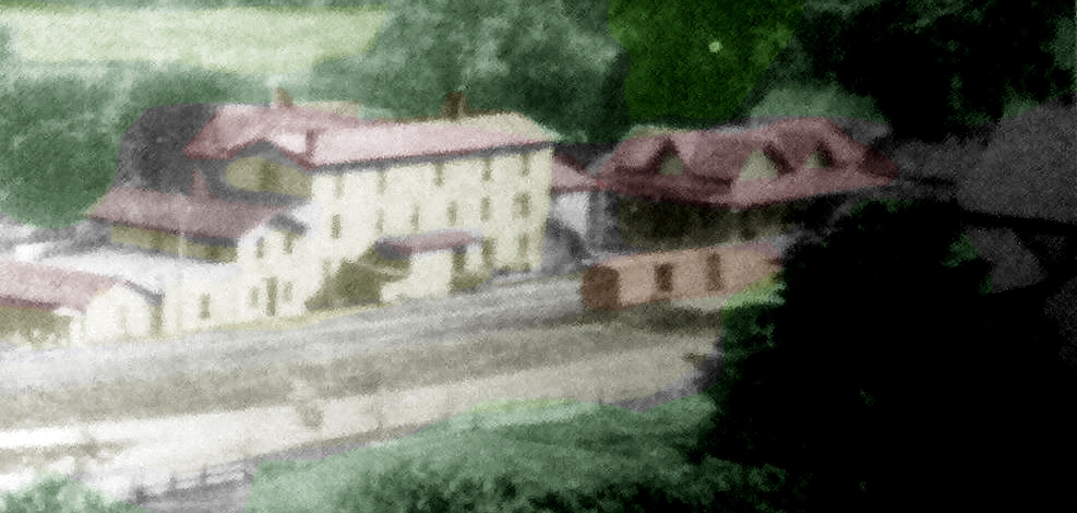
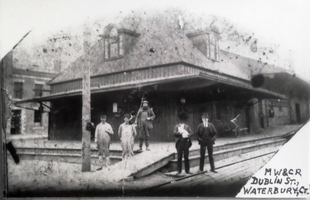
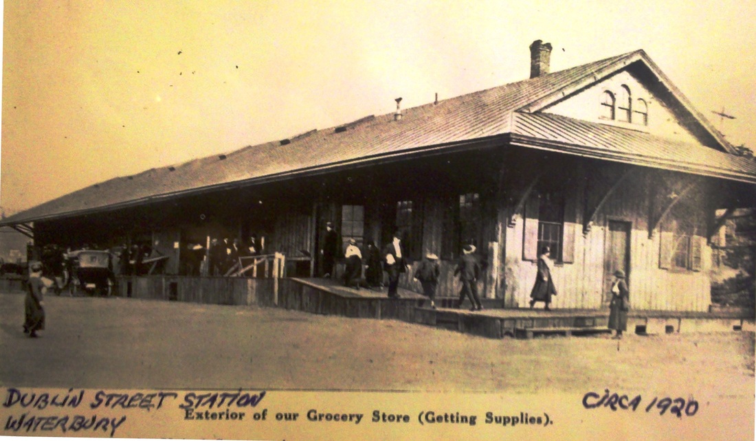
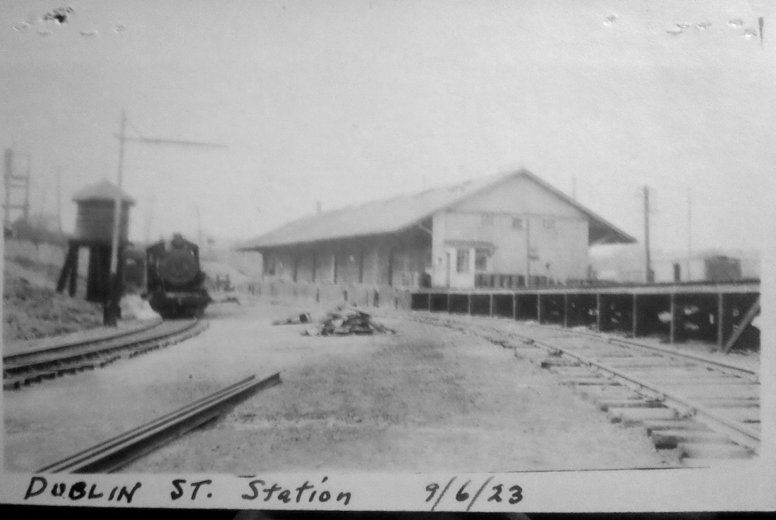
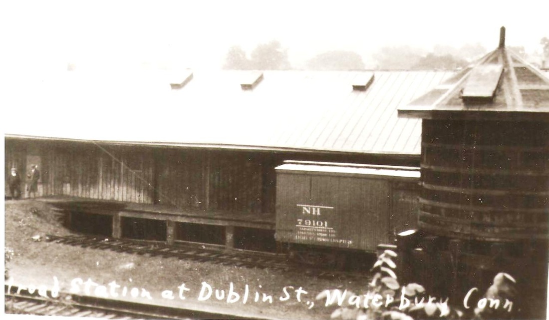
WATERBURY5 [M&W, 1888]
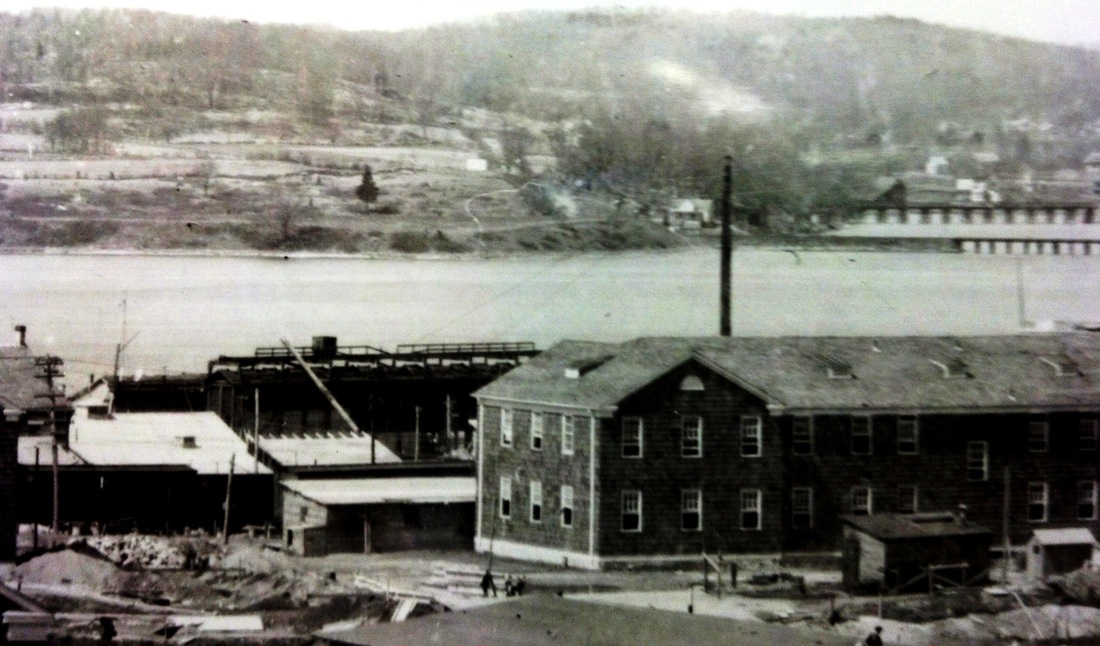
The Dublin St. station was the original terminus of the line in the Brass City. In 1889, track was extended to Meadow St. so that the then-MW&CR could reach the NY&NE's WATERBURY4 station after a lease agreement was inked. The connection was made largely by means of an expansive, circular trestle loop over Waterbury city streets, the Naugatuck River, and the NRR. The bottom photo from the 1980s looks north toward Washington Ave., the loop having been completely rebuilt after the 1955 floods to continue to serve the Scovill Mfg. Co. which was adjacent to the Dublin St. station. The photo at upper left is the only view we have seen of the passenger end of this station, with dormers on the hip-roofed head house facing Dublin St. The one at upper middle is a snippet from the Landis and Hughes 1899 panoramic map showing a pastoral, pre-industrial setting. The shot at upper right is from the Scovill newsletter and, not surprisingly, implies that the depot was serving as the company 'grocery store' ca. 1920. The photos at lower left and middle date to the 1920s and 1930s and no longer show the head house, which may have been removed when passenger service ended under the NYNH&H in 1917. The 1938 SSRR list shows this depot as rented for $600 per year, presumably to Scovill. This station survived a 4/17/1929 fire and, according to Snow, continued to receive LCL freight until July, 1950. At lower right is an aerial shot from the 1950 with the station at the red arrow surrounded by the massive factory complex. Dublin St. would become Hamilton Ave. ca. 1909, possibly through the efforts of the Hamilton Avenue Improvement Association to upgrade that part of the city and broaden the ethnic identity of the area. Though Scovill is still in business today [click here], the factory complex was abandoned and buildings on the 90-acre site were demolished in 1996 after being vacant for 20 years. From the ashes rose the Brass Mill Center Mall in 1997 with the Sears front parking lot marking where WATERBURY5 once stood. [REFS: HC/08/06/1910/13; NL20.6.3; S27][rev010318]
The Dublin St. station was the original terminus of the line in the Brass City. In 1889, track was extended to Meadow St. so that the then-MW&CR could reach the NY&NE's WATERBURY4 station after a lease agreement was inked. The connection was made largely by means of an expansive, circular trestle loop over Waterbury city streets, the Naugatuck River, and the NRR. The bottom photo from the 1980s looks north toward Washington Ave., the loop having been completely rebuilt after the 1955 floods to continue to serve the Scovill Mfg. Co. which was adjacent to the Dublin St. station. The photo at upper left is the only view we have seen of the passenger end of this station, with dormers on the hip-roofed head house facing Dublin St. The one at upper middle is a snippet from the Landis and Hughes 1899 panoramic map showing a pastoral, pre-industrial setting. The shot at upper right is from the Scovill newsletter and, not surprisingly, implies that the depot was serving as the company 'grocery store' ca. 1920. The photos at lower left and middle date to the 1920s and 1930s and no longer show the head house, which may have been removed when passenger service ended under the NYNH&H in 1917. The 1938 SSRR list shows this depot as rented for $600 per year, presumably to Scovill. This station survived a 4/17/1929 fire and, according to Snow, continued to receive LCL freight until July, 1950. At lower right is an aerial shot from the 1950 with the station at the red arrow surrounded by the massive factory complex. Dublin St. would become Hamilton Ave. ca. 1909, possibly through the efforts of the Hamilton Avenue Improvement Association to upgrade that part of the city and broaden the ethnic identity of the area. Though Scovill is still in business today [click here], the factory complex was abandoned and buildings on the 90-acre site were demolished in 1996 after being vacant for 20 years. From the ashes rose the Brass Mill Center Mall in 1997 with the Sears front parking lot marking where WATERBURY5 once stood. [REFS: HC/08/06/1910/13; NL20.6.3; S27][rev010318]
|
|
|
WATERBURY6 [NYNH&H, 1908]
Its location shown at the yellow arrow, this temporary wooden structure was first authorized by the railroad commissioners in 1893. It was used when the two other downtown stations were closed on 3/29/1908 until the new Union Station finally opened on 7/11/1909. The map from the 1891 Waterbury city directory shows the location of all Waterbury's railroad stations. Starting from the lower right, there is WATERBURY5 [green arrow], the 1888 MW&CR station on Dublin St., WATERBURY3, the NRR Bank St. station [red arrow] is shown opposite the site of WATERBURY1, "the meager affair" built by the NRR in 1849 [click here]. WATERBURY2/4, the HPF/NY&NE composite station [blue arrow] is seen on Meadow St., standing exactly where WATERBURY7, the 1909 Union Station, would be built. [rev030215]
Its location shown at the yellow arrow, this temporary wooden structure was first authorized by the railroad commissioners in 1893. It was used when the two other downtown stations were closed on 3/29/1908 until the new Union Station finally opened on 7/11/1909. The map from the 1891 Waterbury city directory shows the location of all Waterbury's railroad stations. Starting from the lower right, there is WATERBURY5 [green arrow], the 1888 MW&CR station on Dublin St., WATERBURY3, the NRR Bank St. station [red arrow] is shown opposite the site of WATERBURY1, "the meager affair" built by the NRR in 1849 [click here]. WATERBURY2/4, the HPF/NY&NE composite station [blue arrow] is seen on Meadow St., standing exactly where WATERBURY7, the 1909 Union Station, would be built. [rev030215]

|
|

|
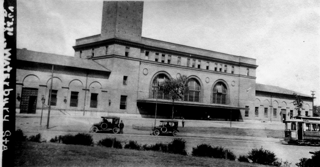
WATERBURY7 [NYNH&H, 1909]
This station, the associated track improvements, grade crossing eliminations, and yard and signal towers were in the planning stages from 1894 until the station finally opened on July 11, 1909. The new Union Station was built immediately adjacent and just south of the site of the old NY&NE station, our WATERBURY4. Designed by the distinguished McKim, Meade and White architectural firm, the station was later purchased by the Republican-American newspaper and is still owned by them. The station was honored with an NRHP designation in 1978. Its 240-ft clock tower is modeled after the Torre del Mangia at city hall in Sienna, Italy. [REFS: HC/11/14/1894/05; NHAR37.1908.8; WA/07/13/1909/07; R103+]
This station, the associated track improvements, grade crossing eliminations, and yard and signal towers were in the planning stages from 1894 until the station finally opened on July 11, 1909. The new Union Station was built immediately adjacent and just south of the site of the old NY&NE station, our WATERBURY4. Designed by the distinguished McKim, Meade and White architectural firm, the station was later purchased by the Republican-American newspaper and is still owned by them. The station was honored with an NRHP designation in 1978. Its 240-ft clock tower is modeled after the Torre del Mangia at city hall in Sienna, Italy. [REFS: HC/11/14/1894/05; NHAR37.1908.8; WA/07/13/1909/07; R103+]
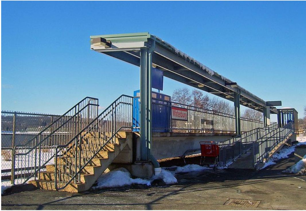
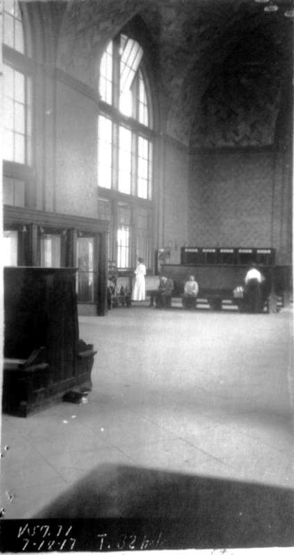
WATERBURY8
This small, open platform south of WATERBURY7 has left commuters unprotected since the baggage-area waiting room in the 1909 station was closed to the public. According the Republican-American, the room is to be reopened and the small building that sits in the parking area is to be razed, creating space for more cars and improving visibility that should deter automotible burglaries that have kept many people away from the lot. [REFS: WRA/07/06/2013/01][rev082113]
This small, open platform south of WATERBURY7 has left commuters unprotected since the baggage-area waiting room in the 1909 station was closed to the public. According the Republican-American, the room is to be reopened and the small building that sits in the parking area is to be razed, creating space for more cars and improving visibility that should deter automotible burglaries that have kept many people away from the lot. [REFS: WRA/07/06/2013/01][rev082113]
WATERFORD/N1 [NH&NL, 1852]
Located on Great Neck Rd. [REFS: CC/07/05/1862/02; IHW95]
WATERFORD/N2 [NYNH&H, 1873]
[REFS: CRC21.1874.19]
Located on Great Neck Rd. [REFS: CC/07/05/1862/02; IHW95]
WATERFORD/N2 [NYNH&H, 1873]
[REFS: CRC21.1874.19]
Edward J. Ozog Collection
|
|
|
 Dale Martin Collection
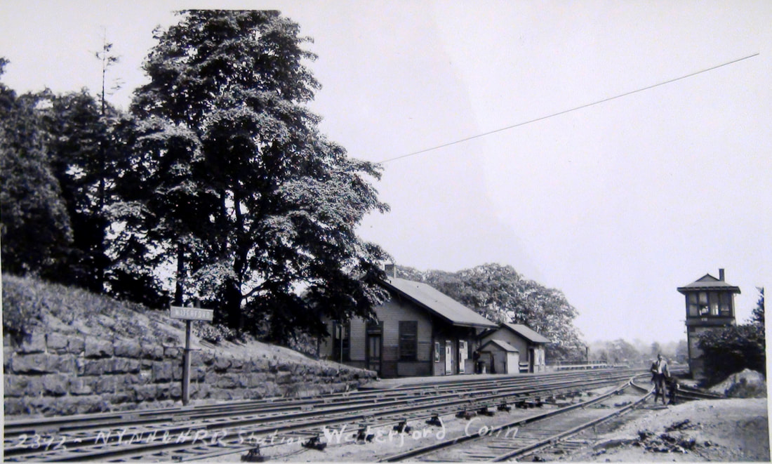
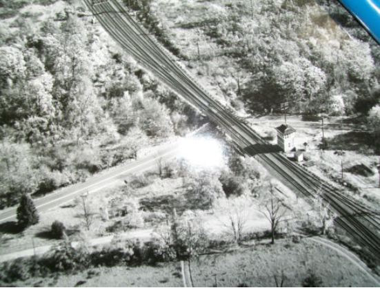
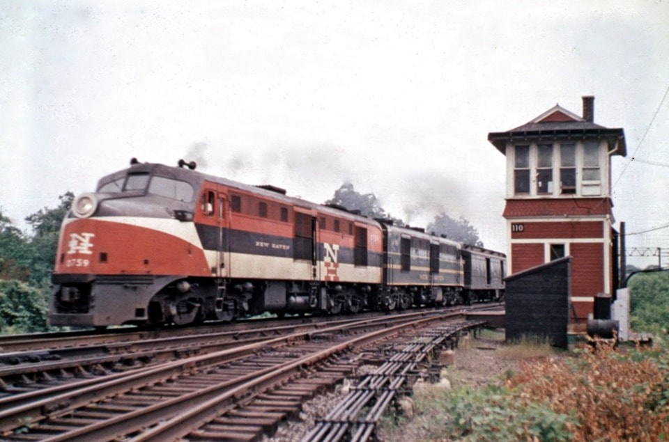
WATERFORD/N3 [NYNH&H, 1895]
This station was built in 1895 by the NYNH&H. Is there anything better than a good depot shot with some great locomotives as a bonus? Such is the case with the photo at [1]. Someone better versed than we are can perhaps better describe what is going on but it looks like the train on the eastbound track has priority over the one "in the hole." SS 110, just behind the photographer, is undoubtedly monitoring these movements. The two crew members standing on the front of the latter engine look eerily like figureheads on the sailing ships of old. The shot at [2] is Lewis H. Benton's #2392 taken in June, 1929. Fellow photographer, chauffeur and frequent foil in Benton's photos, Irving N. Drake, appears to be up to no good playing with the switch. The aerial view at [3] is dated 1954. The shot at [4] is 30 years later. It shows NYNH&H #0759 the only DL-109, painted in McGinnis colors according to retired operator Dale Martin, on the point of an westbound train and passing SS 110. [REFS: CRC43.1895.13][rev082119]
This station was built in 1895 by the NYNH&H. Is there anything better than a good depot shot with some great locomotives as a bonus? Such is the case with the photo at [1]. Someone better versed than we are can perhaps better describe what is going on but it looks like the train on the eastbound track has priority over the one "in the hole." SS 110, just behind the photographer, is undoubtedly monitoring these movements. The two crew members standing on the front of the latter engine look eerily like figureheads on the sailing ships of old. The shot at [2] is Lewis H. Benton's #2392 taken in June, 1929. Fellow photographer, chauffeur and frequent foil in Benton's photos, Irving N. Drake, appears to be up to no good playing with the switch. The aerial view at [3] is dated 1954. The shot at [4] is 30 years later. It shows NYNH&H #0759 the only DL-109, painted in McGinnis colors according to retired operator Dale Martin, on the point of an westbound train and passing SS 110. [REFS: CRC43.1895.13][rev082119]
|
|
WATERFORD/W1 [CVT, c1870?]
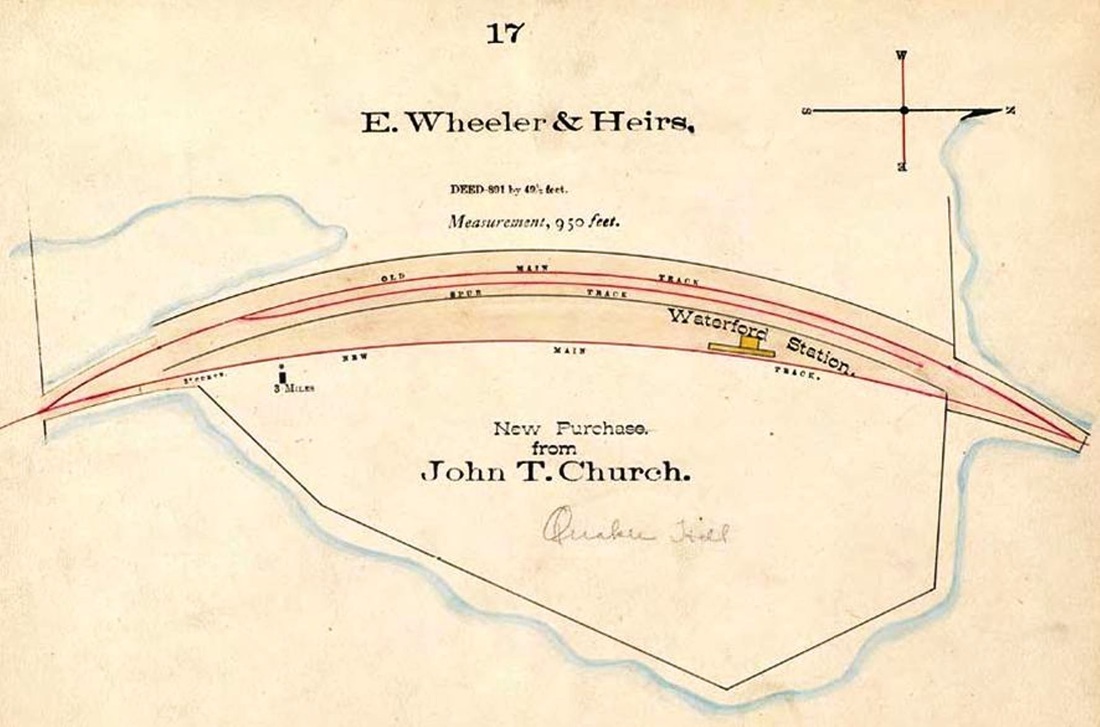
The earliest NLW&P timetables show no station in this town and an 1857 newspaper article says that the first stop up from NEW LONDON at that time was MONTVILLE. While it is surprising that a railroad would go six miles without a stop even in its earliest days, the red arrow on the 1868 Beers map [1] shows no station here. The first timetable we have seen that shows a WATERFORD station is 1871 and the earliest written mentions are both in 1876, with the report that the northbound steamboat train "struck and killed... Timothy Donahue near the Waterford station" and a reference in the records of the railroad commissioners to a petition by the then-NLN for taking land near the depot. This probably is that which was obtained from John T. Church and noted on the 1883 NLN real estate map [2], which shows also shows a trackage realignment that may have been connected with the land purchase. These developments dovetail with an 1883 article saying that this was now the first stop, four miles above New London. The location is just south of the Smiths Cove bridge at the foot of today's Richards Grove Rd. The Illustrated History of Waterford [p94] says the early depot here, presumably the first, was about 8-feet square and "hard to find in a winter snowstorm by the trainmen." It burned in 1894 according to information the book gives from the New London Day without citation. We have no photo yet of the diminutive first station but the footprint on the 1883 map may well be a match for the size. [REFS: NLDC/07/13/1857/02; 1871TT; PTH18.1875.49; CR/06/10/1876/01; NC/08/16/1876/08; RRC25.11 (9/16/1876); CRC26.1879.26; NHER/09/13/1883/01; RAM1897-1939: yes][rev011314]
The earliest NLW&P timetables show no station in this town and an 1857 newspaper article says that the first stop up from NEW LONDON at that time was MONTVILLE. While it is surprising that a railroad would go six miles without a stop even in its earliest days, the red arrow on the 1868 Beers map [1] shows no station here. The first timetable we have seen that shows a WATERFORD station is 1871 and the earliest written mentions are both in 1876, with the report that the northbound steamboat train "struck and killed... Timothy Donahue near the Waterford station" and a reference in the records of the railroad commissioners to a petition by the then-NLN for taking land near the depot. This probably is that which was obtained from John T. Church and noted on the 1883 NLN real estate map [2], which shows also shows a trackage realignment that may have been connected with the land purchase. These developments dovetail with an 1883 article saying that this was now the first stop, four miles above New London. The location is just south of the Smiths Cove bridge at the foot of today's Richards Grove Rd. The Illustrated History of Waterford [p94] says the early depot here, presumably the first, was about 8-feet square and "hard to find in a winter snowstorm by the trainmen." It burned in 1894 according to information the book gives from the New London Day without citation. We have no photo yet of the diminutive first station but the footprint on the 1883 map may well be a match for the size. [REFS: NLDC/07/13/1857/02; 1871TT; PTH18.1875.49; CR/06/10/1876/01; NC/08/16/1876/08; RRC25.11 (9/16/1876); CRC26.1879.26; NHER/09/13/1883/01; RAM1897-1939: yes][rev011314]

|
Tim Satterlee photo
|
|
|
|
|
WATERFORD/W2 [CVT, 1894]
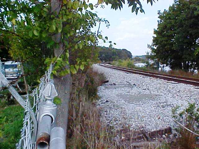
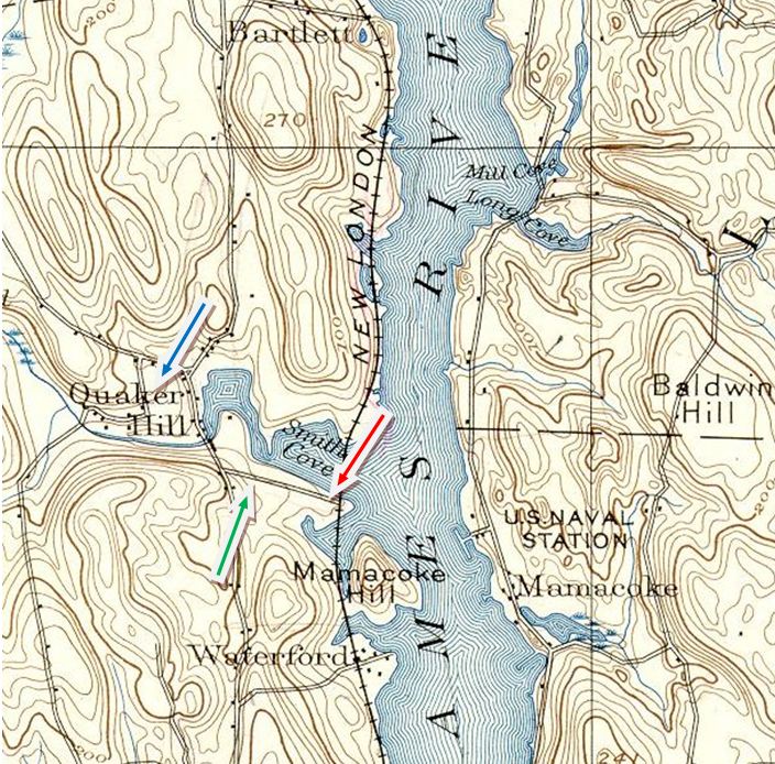
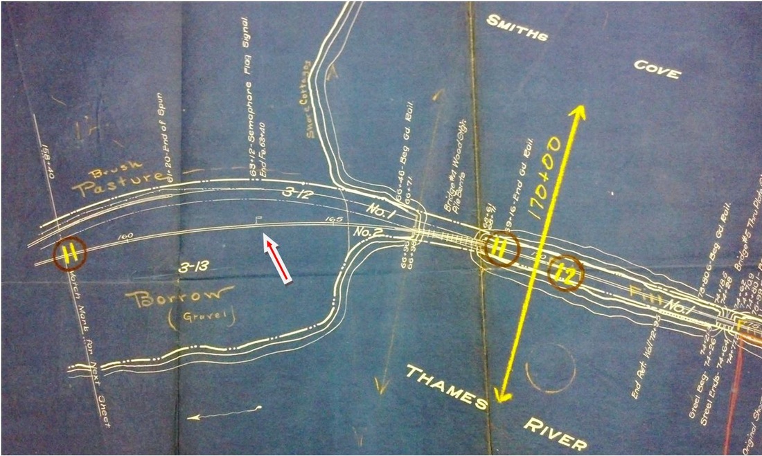
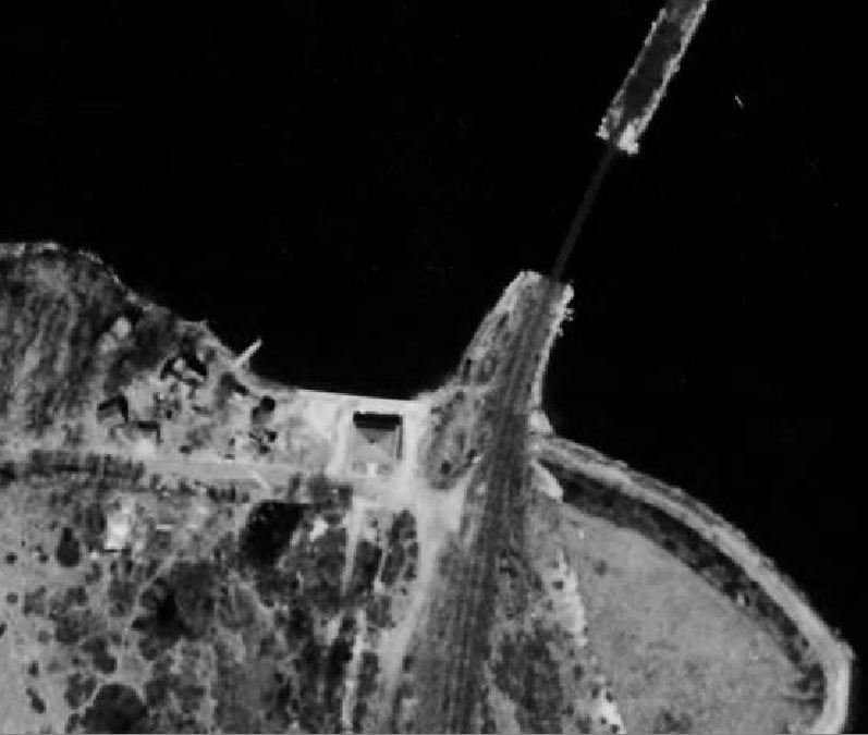
Based on the 1894 burn date of the earlier station, we have put the replacement of this small shelter in the same year. It was described in 1898 as holding "10 persons standing up; seats four or five," in the same year. Photo [1] has been thought by some to be BARTLETTS, but the similarity of the view [2] makes us think that this structure actually stood at the end of Richards Grove Rd. On the 1893 topo map [3], the red arrow points to where the WATERFORD station was, the green arrow to the grove location, and the blue arrow to the Quaker Hill district, which gave this locale one of its alternate names. The station seen here likely was the one that burned on 11/29/1909 and, since the newspaper said it "was used but little, except during the summer months, it may not have been rebuilt. Shortly thereafter, the 1917 val map [4] shows only a "Semaphore Flag Signal" where the waiting shed once stood. Image [5] looks from NAVY YARD across to Waterford and shows no station that we can discern. The railroad causeway is seen as well as the trolley bridge across the cove behind it. The 1934 aerial map [6] shows a larger structure, more or less where the old station stood which may mean a sale of property which would otherwise explain why a 4/26/1936TT shows passenger service moved to SCOTCH CAP, just north of the cove. Image [7] is a 1914 interurban map showing the trolley station where the shore leave boat docked and sailors caught the cars for points north and south. The trolley line was converted to bus on 3/18/1934. [REFS: NLD/08/30/1898/07; NLD/07/10/1904/07; NLD/11/30/1909/02][rev011714]
Based on the 1894 burn date of the earlier station, we have put the replacement of this small shelter in the same year. It was described in 1898 as holding "10 persons standing up; seats four or five," in the same year. Photo [1] has been thought by some to be BARTLETTS, but the similarity of the view [2] makes us think that this structure actually stood at the end of Richards Grove Rd. On the 1893 topo map [3], the red arrow points to where the WATERFORD station was, the green arrow to the grove location, and the blue arrow to the Quaker Hill district, which gave this locale one of its alternate names. The station seen here likely was the one that burned on 11/29/1909 and, since the newspaper said it "was used but little, except during the summer months, it may not have been rebuilt. Shortly thereafter, the 1917 val map [4] shows only a "Semaphore Flag Signal" where the waiting shed once stood. Image [5] looks from NAVY YARD across to Waterford and shows no station that we can discern. The railroad causeway is seen as well as the trolley bridge across the cove behind it. The 1934 aerial map [6] shows a larger structure, more or less where the old station stood which may mean a sale of property which would otherwise explain why a 4/26/1936TT shows passenger service moved to SCOTCH CAP, just north of the cove. Image [7] is a 1914 interurban map showing the trolley station where the shore leave boat docked and sailors caught the cars for points north and south. The trolley line was converted to bus on 3/18/1934. [REFS: NLD/08/30/1898/07; NLD/07/10/1904/07; NLD/11/30/1909/02][rev011714]

|
|

|

|
|
|
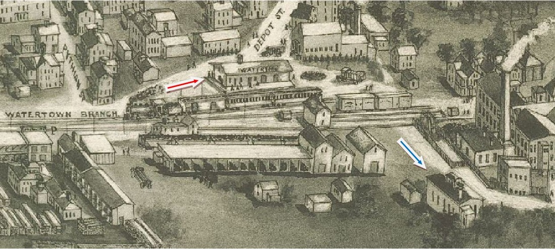
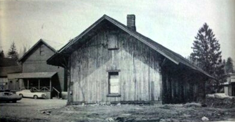
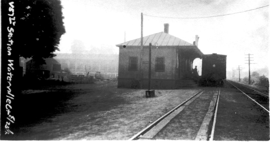
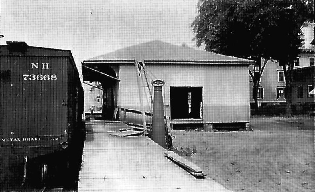
WATERTOWN [W&W, 1870]
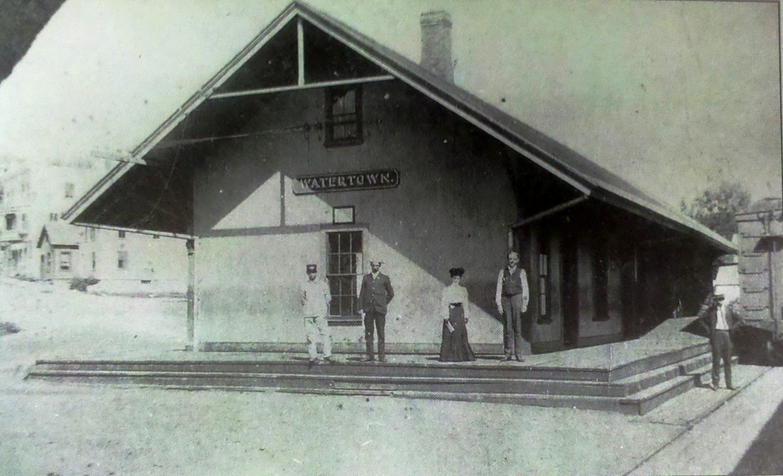
The original depot is shown in the photo at upper left, on opening described as "a neat building 30 by 60 feet with ladies' and gents' rooms, ticket, baggage and freight offices and other conveniences." Water was reportedly piped from a spring up the hill until about 1900 when the station and the engine house were hooked up to the town's water supply. The shot at upper middle dates to 1897. This station was the terminus of the 4-mile W&W that was immediately leased to the NRR on opening in 1870. Henry Stearns says that NRR #11, the Seymour, was originally used on this line because its slope-back tender enabled it to run without turning the locomotive. The 1893 map at upper right shows the turntable and engine house that were probably built by the NYNH&H after the 1887 lease of the NRR. By the 8/29/1915 val photo at lower left, we see an addition marked by different roof shingles that more than doubled the structure in size and added a second chimney. The bird's-eye image at lower middle is from the Hughes & Bailey map of 1918 and shows the bustling activity around the station at our red arrow. The blue arrow points to the engine house, though the turntable is a detail that was not included by the artist. Stearns has a photo of the engine house still standing in 1926 when it was "long out of service." The last train into Watertown was in 1974 and the depot was still standing in 1976, as seen at lower right. [REFS: CRC56.1908.49; D102+; SL11.2.2.22,25 (1980)][rev121613]
The original depot is shown in the photo at upper left, on opening described as "a neat building 30 by 60 feet with ladies' and gents' rooms, ticket, baggage and freight offices and other conveniences." Water was reportedly piped from a spring up the hill until about 1900 when the station and the engine house were hooked up to the town's water supply. The shot at upper middle dates to 1897. This station was the terminus of the 4-mile W&W that was immediately leased to the NRR on opening in 1870. Henry Stearns says that NRR #11, the Seymour, was originally used on this line because its slope-back tender enabled it to run without turning the locomotive. The 1893 map at upper right shows the turntable and engine house that were probably built by the NYNH&H after the 1887 lease of the NRR. By the 8/29/1915 val photo at lower left, we see an addition marked by different roof shingles that more than doubled the structure in size and added a second chimney. The bird's-eye image at lower middle is from the Hughes & Bailey map of 1918 and shows the bustling activity around the station at our red arrow. The blue arrow points to the engine house, though the turntable is a detail that was not included by the artist. Stearns has a photo of the engine house still standing in 1926 when it was "long out of service." The last train into Watertown was in 1974 and the depot was still standing in 1976, as seen at lower right. [REFS: CRC56.1908.49; D102+; SL11.2.2.22,25 (1980)][rev121613]
Dave Peters Collection
|
|

|
|
|
|
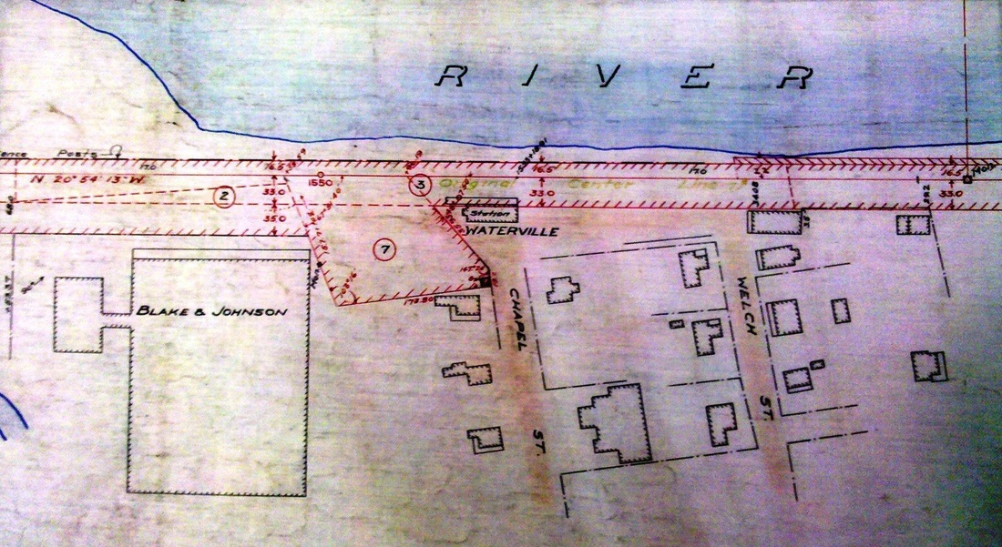
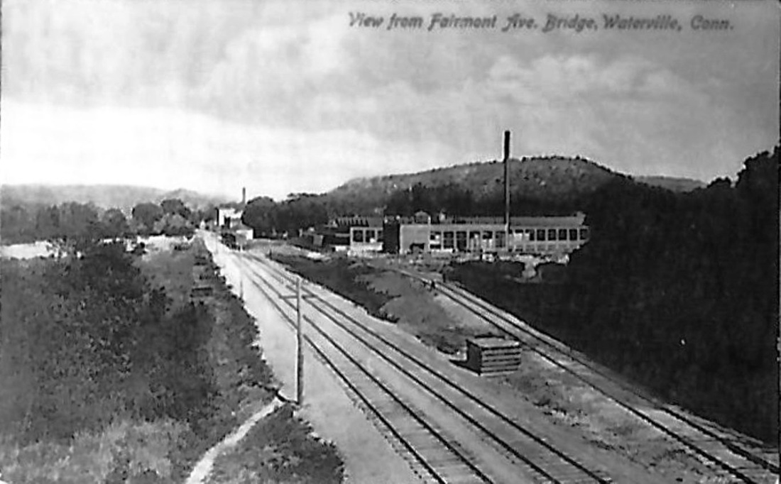
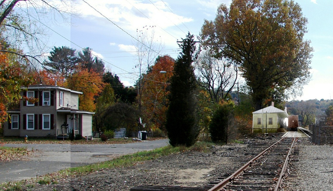
WATERVILLE/N [NRR, 1849]
This village is in the northwestern part of Waterbury. The structure pictured in these photos is the only one we have seen for this stop and closely resembles other 1849 NRR stations, e.g. BURRVILLE1, SEYMOUR1, etc. The 8/23/1916 val photo at upper left looks south and shows the depot standing east of the track. The undated image at upper middle looks north. The 1893 map at upper right illustrates the close proximity of the two village railroad stations, with the NRR running along its namesake river and the then-NY&NE seeking a northeasterly course toward BRISTOL, whence it opened in 1855. The 1911 railroad real estate map at lower left shows the layout of the station grounds as well as the Blake & Johnson factory seen in the northward postcard view at lower middle. Fairmont Ave. must be today's Huntingdon Ave. where there is still a bridge over the old NRR. Al Weaver's ghost-station image at lower right looks toward Waterbury and has the depot located at the foot of Chapel St. as shown on the maps. This station's demise came after the 1955 floods when it was reportedly washed two miles downstream and destroyed by the raging river. [rev091618]
This village is in the northwestern part of Waterbury. The structure pictured in these photos is the only one we have seen for this stop and closely resembles other 1849 NRR stations, e.g. BURRVILLE1, SEYMOUR1, etc. The 8/23/1916 val photo at upper left looks south and shows the depot standing east of the track. The undated image at upper middle looks north. The 1893 map at upper right illustrates the close proximity of the two village railroad stations, with the NRR running along its namesake river and the then-NY&NE seeking a northeasterly course toward BRISTOL, whence it opened in 1855. The 1911 railroad real estate map at lower left shows the layout of the station grounds as well as the Blake & Johnson factory seen in the northward postcard view at lower middle. Fairmont Ave. must be today's Huntingdon Ave. where there is still a bridge over the old NRR. Al Weaver's ghost-station image at lower right looks toward Waterbury and has the depot located at the foot of Chapel St. as shown on the maps. This station's demise came after the 1955 floods when it was reportedly washed two miles downstream and destroyed by the raging river. [rev091618]
|

|
|
WATERVILLE/E1 [HP&F, 1855]
The HP&F opened from Bristol to Waterbury in 1855 and this may be the first station that stood here. We do not know how literally we can take the captioning at the bottom of the photo that says 'NY&NE station' but we think the view does predate the 1906 double-tracking of the Highland Division. A newspaper report in 1897 said storm damage necessitated the rebuilding of 200 feet of embankment that was 45 feet deep so that would account for the elevated ROW seen in the photo and, in fact, the storm could have caused the demise of this station, as minimal as it was. All things considered and since the next depots have firmer dates, the only place for this one seems to be prior to them. At right is a 12/1/1878 timetable showing several NY&NE trains stopping at this station. [REFS: HDC/06/13/1873/01; CC/08/21/1875/03; CR/08/28/1875/02; HDC/09/10/1875/02; HC/07/23/1897/05][rev091818]
The HP&F opened from Bristol to Waterbury in 1855 and this may be the first station that stood here. We do not know how literally we can take the captioning at the bottom of the photo that says 'NY&NE station' but we think the view does predate the 1906 double-tracking of the Highland Division. A newspaper report in 1897 said storm damage necessitated the rebuilding of 200 feet of embankment that was 45 feet deep so that would account for the elevated ROW seen in the photo and, in fact, the storm could have caused the demise of this station, as minimal as it was. All things considered and since the next depots have firmer dates, the only place for this one seems to be prior to them. At right is a 12/1/1878 timetable showing several NY&NE trains stopping at this station. [REFS: HDC/06/13/1873/01; CC/08/21/1875/03; CR/08/28/1875/02; HDC/09/10/1875/02; HC/07/23/1897/05][rev091818]

|

|
|
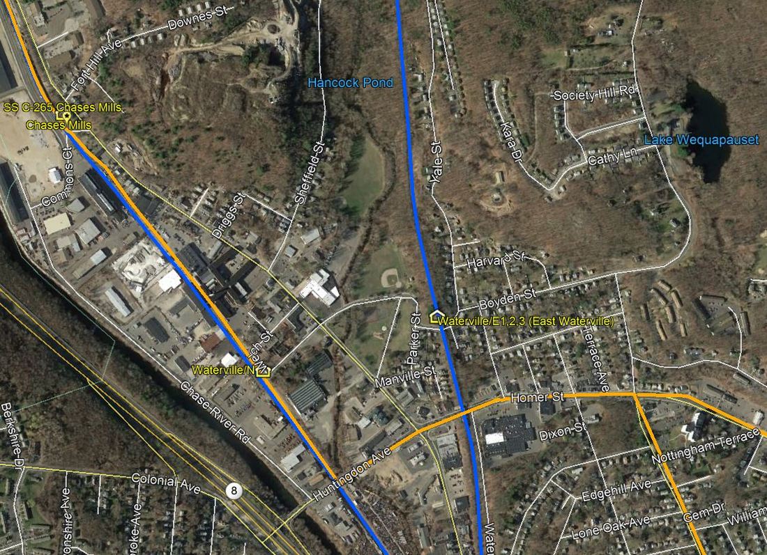
WATERVILLE/E2 [NERR?, 1897?]
We do not know if the NY&NE built this structure or it came later under the NYNH&H which got control of the line in 1895. It may have come about as a result of the 1897 storm discussed in the previous listing. The val photo at left was taken on 8/22/1916 and the 1915 val map at middle shows the layout of the station area at that same time. Note the break in the railing in the photo for the staircase coming up to the north side of the depot, as seen on the val map at our red arrow. This station would be renamed EAST WATERVILLE some time between 1907 and 1910. The snippet from our CTTRAXMAP at right shows today's view of the railroad lines that still traverse this section of the Brass City. [REFS: HC/09/10/1897/08; HC/02/04/1898/07; CRC46.1898.22][rev091818]
We do not know if the NY&NE built this structure or it came later under the NYNH&H which got control of the line in 1895. It may have come about as a result of the 1897 storm discussed in the previous listing. The val photo at left was taken on 8/22/1916 and the 1915 val map at middle shows the layout of the station area at that same time. Note the break in the railing in the photo for the staircase coming up to the north side of the depot, as seen on the val map at our red arrow. This station would be renamed EAST WATERVILLE some time between 1907 and 1910. The snippet from our CTTRAXMAP at right shows today's view of the railroad lines that still traverse this section of the Brass City. [REFS: HC/09/10/1897/08; HC/02/04/1898/07; CRC46.1898.22][rev091818]
|
Mattatuck Museum
|
|
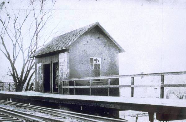
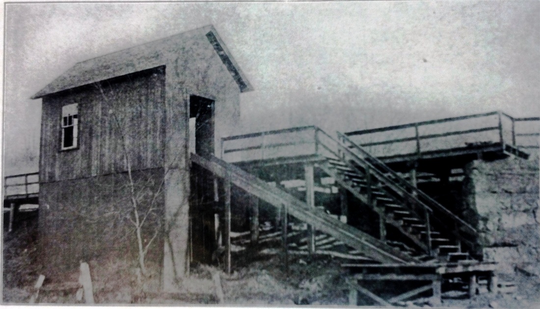
WATERVILLE/E3 [NYNH&H, 1920s?]
The shot at left reportedly dates to the 1950s and appears to show a different structure. This one is wider, has no chimney, the entrance is now double-doored, the platform is raised and the railings have been reconfigured. The photo at middle shows the rear of the structure, with the staircase now coming up directly to the south side of the building and what appears to be a freight ramp down to the street. At right, Al Weaver's ghostly superimposition shows this station in place on the site in 2013. What caused this depot to replace the previous one is not known and the fate of this one is unknown as well. [add121413]
The shot at left reportedly dates to the 1950s and appears to show a different structure. This one is wider, has no chimney, the entrance is now double-doored, the platform is raised and the railings have been reconfigured. The photo at middle shows the rear of the structure, with the staircase now coming up directly to the south side of the building and what appears to be a freight ramp down to the street. At right, Al Weaver's ghostly superimposition shows this station in place on the site in 2013. What caused this depot to replace the previous one is not known and the fate of this one is unknown as well. [add121413]

WAUREGAN1 [N&W, 1859]
The first station here in the northern part of PLAINFIELD was not established until 1859. The Wauregan Manufacturing Co. was chartered in 1853 and its owner, James S. Atwood, [click here] "took great pride in the village which he saw, under the fostering care and ownership of the company, develop into one of the model hamlets of the vicinity." Residences for employees, a dairy farm, electric light company, general store, post office were constructed over time, as well as a building that contained a firehouse and jail, with a reading room and library on the upper floor. An article we chanced upon says that WAUREGAN1, on the "Newport(!) and Worcester road" burned in July, 1882 and "all the books, papers, tickets, etc., were destroyed." [REFS: 1851TT: no; HDC/06/24/1853/02; 1858TT: no; 1871TT: yes; CWN/07/12/1882/02]
The first station here in the northern part of PLAINFIELD was not established until 1859. The Wauregan Manufacturing Co. was chartered in 1853 and its owner, James S. Atwood, [click here] "took great pride in the village which he saw, under the fostering care and ownership of the company, develop into one of the model hamlets of the vicinity." Residences for employees, a dairy farm, electric light company, general store, post office were constructed over time, as well as a building that contained a firehouse and jail, with a reading room and library on the upper floor. An article we chanced upon says that WAUREGAN1, on the "Newport(!) and Worcester road" burned in July, 1882 and "all the books, papers, tickets, etc., were destroyed." [REFS: 1851TT: no; HDC/06/24/1853/02; 1858TT: no; 1871TT: yes; CWN/07/12/1882/02]

|
|
WAUREGAN2 [NY&NE, 1882]
The NY&NE annual report says that $1425 was expended for the new depot here. [REFS: NYNEAR8.1883.49; CRC31.1884.21][rev010215]
The NY&NE annual report says that $1425 was expended for the new depot here. [REFS: NYNEAR8.1883.49; CRC31.1884.21][rev010215]
|
|

|
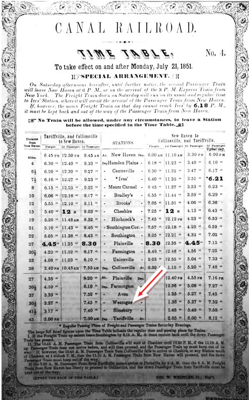
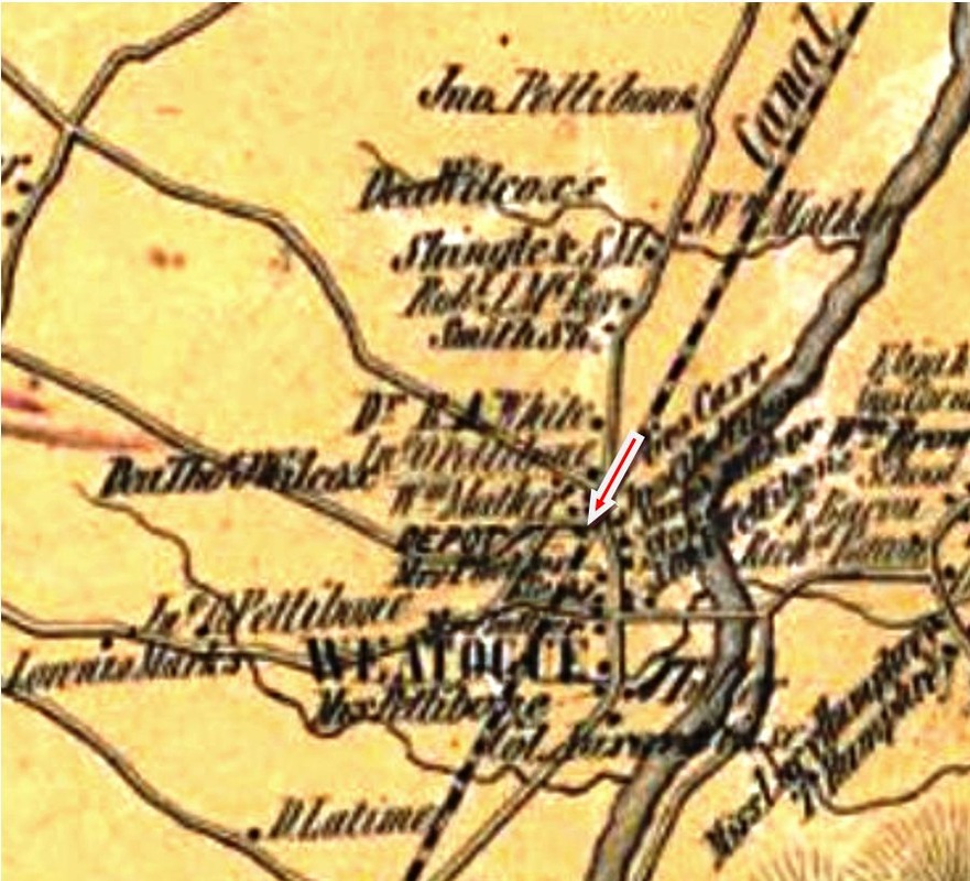
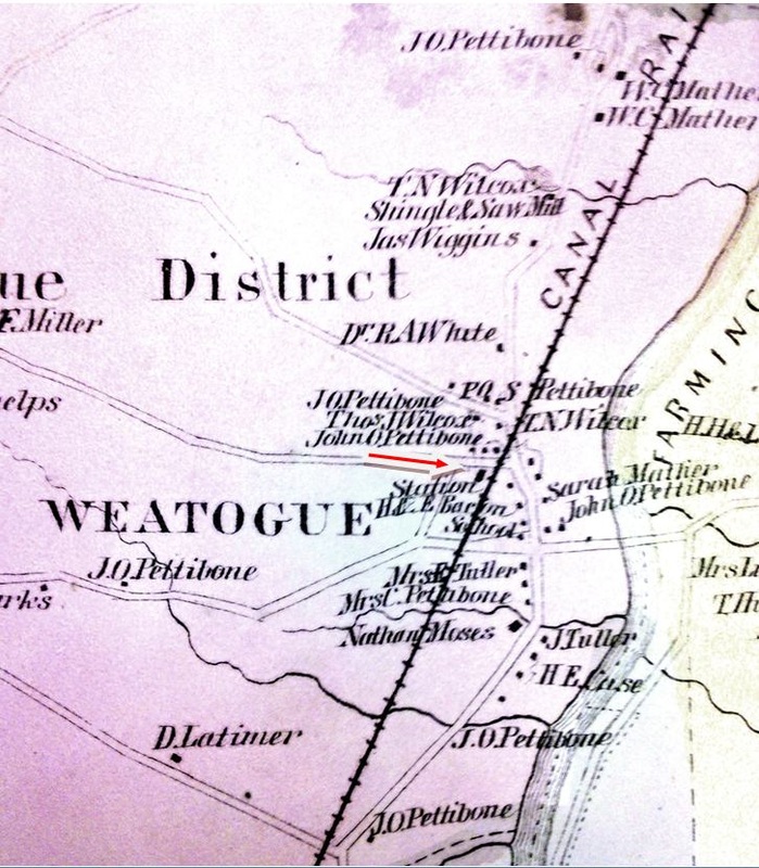
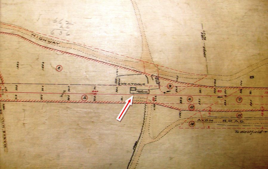
WEATOGUE1 [NH&N, 1849]
This probably was an original stop in the town of Simsbury when the Canal line built from PLAINVILLE to GRANBY in 1850. It at least appears on the 7/21/1851 timetable at [4], with two daily trains stopping in each direction. The location is seen on the 1855HC map at [1] and the 1869 map at [2] and both show the depot in the southwest quadrant of the grade crossing on today's Sand Hill Rd. The icon on the snippet from our Track 11 Google Earth map at right shows the location. We have no photo of the first station here. More than likely something small, it burned sometime in September, 1881, according to a petition signed by several residents who complained that they were entitled to have trains stop here, since the next station [SIMSBURY] was two miles north and the next one south [AVON] was three miles away. By law, the railroad commissioners could force the railroad to stop at any village of 200 inhabitants that was more than a mile and a half from the next stop. Curiously, the petition was addressed to the directors of the Consolidated Railroad, even though the NYNH&H would not lease the Canal line for the second time until 1887. The ensuing conflict would soon involve the railroad commissioners who determined that, not only had trains treated this as a timetable stop with tickets sold to this location, but that there was once an agent here and a freight siding as well. Now those were gone and the Canal line was treating this as a flag stop, much to the dismay of the locals, who wanted their station rebuilt and the scheduled service they once had. The Canal line, already smarting from its recent defeat over PLANTSVILLE3, made another public relations blunder and balked but was ultimately forced to acquiesce. Among the most salient points against them was that this station was never formally abandoned in the first place, a move that required the consent of the railroad commissioners for any stop that had been in service for a year. [REFS: HDC/08/27/1862/02; CRC34.1886 .38,53+][rev020518]
This probably was an original stop in the town of Simsbury when the Canal line built from PLAINVILLE to GRANBY in 1850. It at least appears on the 7/21/1851 timetable at [4], with two daily trains stopping in each direction. The location is seen on the 1855HC map at [1] and the 1869 map at [2] and both show the depot in the southwest quadrant of the grade crossing on today's Sand Hill Rd. The icon on the snippet from our Track 11 Google Earth map at right shows the location. We have no photo of the first station here. More than likely something small, it burned sometime in September, 1881, according to a petition signed by several residents who complained that they were entitled to have trains stop here, since the next station [SIMSBURY] was two miles north and the next one south [AVON] was three miles away. By law, the railroad commissioners could force the railroad to stop at any village of 200 inhabitants that was more than a mile and a half from the next stop. Curiously, the petition was addressed to the directors of the Consolidated Railroad, even though the NYNH&H would not lease the Canal line for the second time until 1887. The ensuing conflict would soon involve the railroad commissioners who determined that, not only had trains treated this as a timetable stop with tickets sold to this location, but that there was once an agent here and a freight siding as well. Now those were gone and the Canal line was treating this as a flag stop, much to the dismay of the locals, who wanted their station rebuilt and the scheduled service they once had. The Canal line, already smarting from its recent defeat over PLANTSVILLE3, made another public relations blunder and balked but was ultimately forced to acquiesce. Among the most salient points against them was that this station was never formally abandoned in the first place, a move that required the consent of the railroad commissioners for any stop that had been in service for a year. [REFS: HDC/08/27/1862/02; CRC34.1886 .38,53+][rev020518]
National Archives
|
|
WEATOGUE2 [NH&N, 1886]
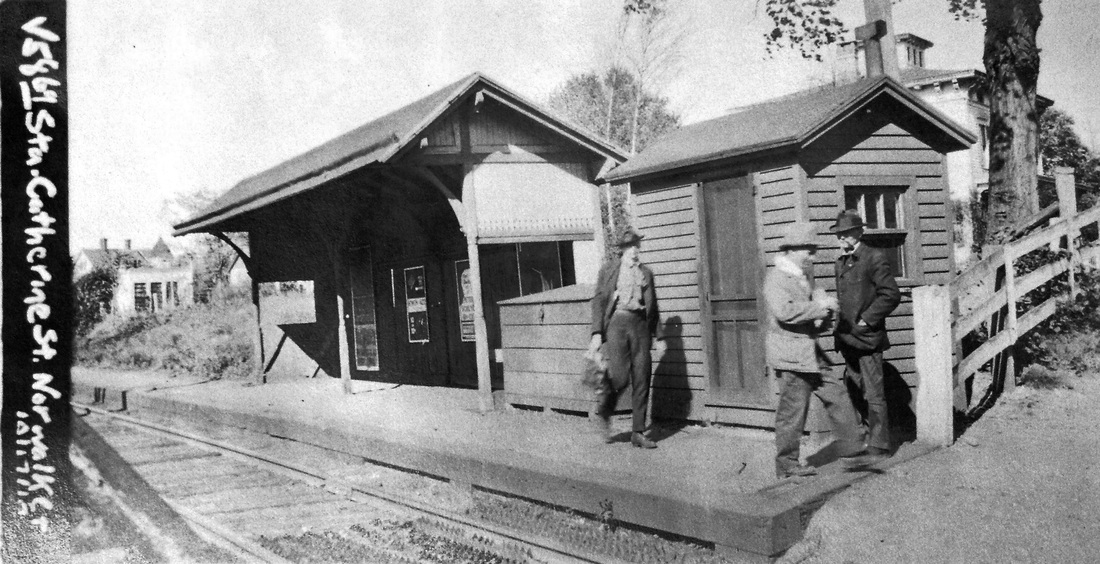
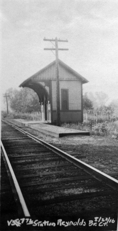
In response to the wrangling over station facilities here, the commissioners issued the following order. "We do, therefore require and recommend that within sixty days from the date hereof the New Haven & Northampton Company erect and hereafter maintain on the site of the former depot building and platform at its Weatogue station, a platform with a portion thereof covered and enclosed, suitable for the accommodation of passengers and their baggage, and in style similar to the new flag station on the Danbury & Norwalk railroad at Catharine [sic] street in Norwalk, or the new flag stations on the New York & New England railroad, or the Reynolds' Bridge station on the Naugatuck railroad, and also provide for use thereat a suitable flag for day and lantern for night." The commissioners further recommended that the freight siding be restored, "so far as that can be done without keeping an agent at that station." We do not know what style was chosen but we have reproduced the candidates specifically suggested, CATHERINE STREET at [1] and REYNOLDS BRIDGE at [3]. The depot footprint on the ca. 1886 real estate map at right makes us lean toward the former suggestion. Whatever was built here apparently needed to be replaced by 1894. Fire is the usual suspect. [REFS: RRC24.146,149 (11/3/1886); CRC34.1886.57][rev020518]
In response to the wrangling over station facilities here, the commissioners issued the following order. "We do, therefore require and recommend that within sixty days from the date hereof the New Haven & Northampton Company erect and hereafter maintain on the site of the former depot building and platform at its Weatogue station, a platform with a portion thereof covered and enclosed, suitable for the accommodation of passengers and their baggage, and in style similar to the new flag station on the Danbury & Norwalk railroad at Catharine [sic] street in Norwalk, or the new flag stations on the New York & New England railroad, or the Reynolds' Bridge station on the Naugatuck railroad, and also provide for use thereat a suitable flag for day and lantern for night." The commissioners further recommended that the freight siding be restored, "so far as that can be done without keeping an agent at that station." We do not know what style was chosen but we have reproduced the candidates specifically suggested, CATHERINE STREET at [1] and REYNOLDS BRIDGE at [3]. The depot footprint on the ca. 1886 real estate map at right makes us lean toward the former suggestion. Whatever was built here apparently needed to be replaced by 1894. Fire is the usual suspect. [REFS: RRC24.146,149 (11/3/1886); CRC34.1886.57][rev020518]

National Archives
|

|
|
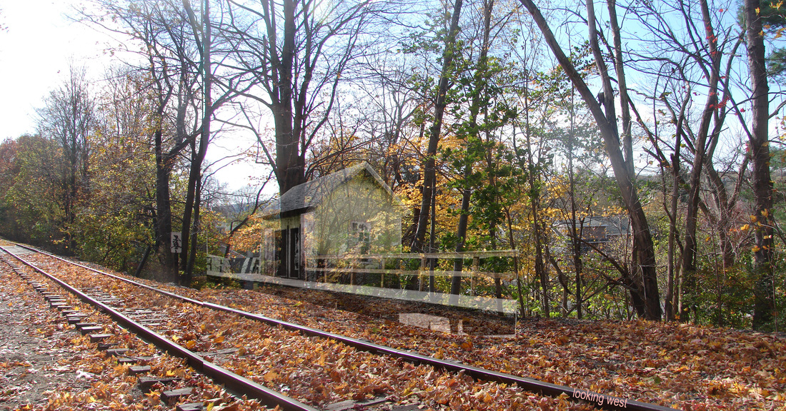
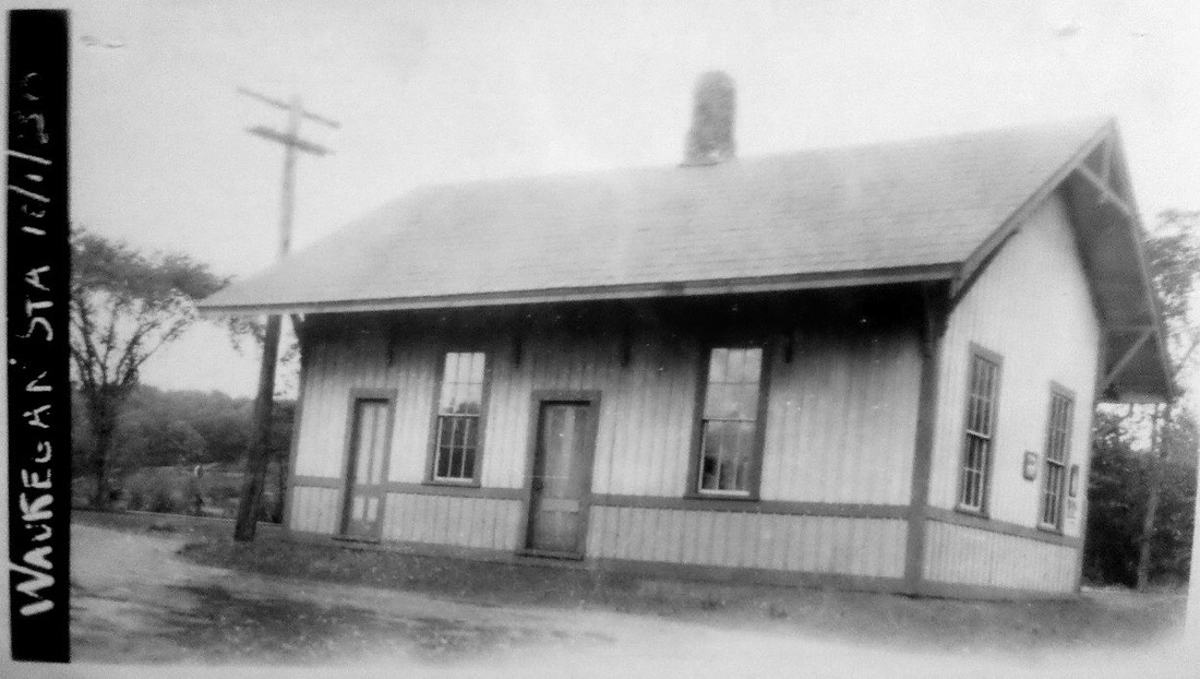
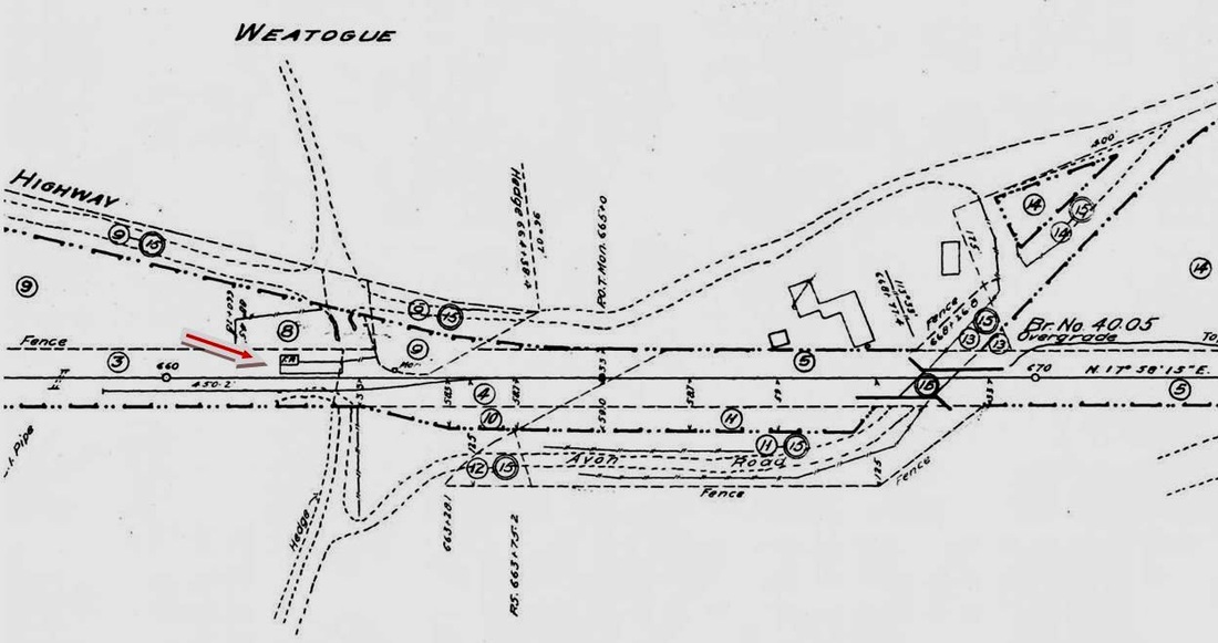
WEATOGUE3 [NYNH&H, 1894]
The commissioners say in their 1894 annual report issued in December that "a small but neat new passenger station building has been erected at Weatogue." We have to assume that it is the building that the in the 4/29/1916 val photo at [1]. No mention is made of the fate of the preceding structure. The 1915 val map at [3] shows the freight siding back in place and also the highway changes that came in 1910 with the elimination of the grade crossing. [REFS: CRC42.1894.20; HC/01/28/1910/02; HC/04/11/1910/03; D111][rev020518]
The commissioners say in their 1894 annual report issued in December that "a small but neat new passenger station building has been erected at Weatogue." We have to assume that it is the building that the in the 4/29/1916 val photo at [1]. No mention is made of the fate of the preceding structure. The 1915 val map at [3] shows the freight siding back in place and also the highway changes that came in 1910 with the elimination of the grade crossing. [REFS: CRC42.1894.20; HC/01/28/1910/02; HC/04/11/1910/03; D111][rev020518]
|

|

|
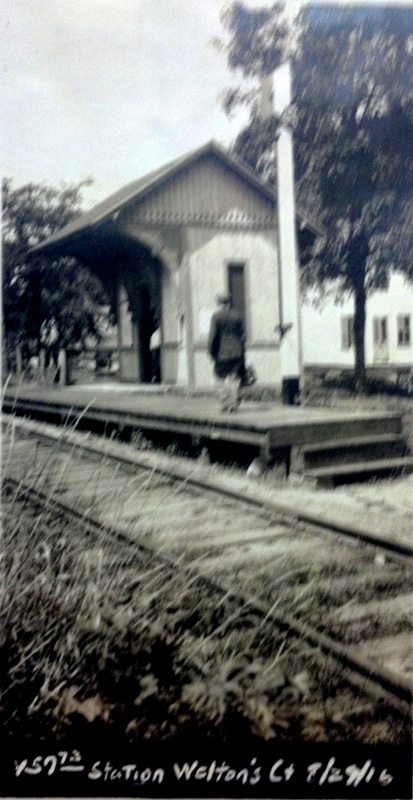
WELTONS [NYNH&H, 1887?]
According to Henry P. Stearns in a Shoreliner article on the Watertown and Waterbury RR, this WATERTOWN flag stop was established in May, 1887 and was about opposite where the the Ray Garnsey garage stood on Main St. in 1950. The station does not, however, appear on timetables we consulted until the 7/15/1894rev timetable shown at middle. The real estate map at upper left is dated 12/30/1912 and shows the platform and shelter on the north side of the track where today the intersecting Welton St. on the GE map at right seems to corroborate the location. While the name Welton was prominent historically all over the area, the land here for the railroad was actually purchased from a David Welton, who Stearns says was "the railroad's inspector" who boarded here on the first run to Watertown in 1870. The 4.9-mile W&W was built with the backing of the NRR and later purchased by it to tap the industrial traffic of Oakville and Watertown. The NRR and W&W were leased by the NYNH&H on 4/1887. The shelter is typical NRR style, found also at BALDWINS and as CAMPVILLE3. The val photo at lower left appears to be dated 8/29/1916. According to Karr, passenger service ended on the Watertown branch ca. 1925. [REFS: 1890,1892,1893TT: no; 1894TT: yes; 1923TT: yes; K63; SL11.2.22,24 (1980)][rev121713]
According to Henry P. Stearns in a Shoreliner article on the Watertown and Waterbury RR, this WATERTOWN flag stop was established in May, 1887 and was about opposite where the the Ray Garnsey garage stood on Main St. in 1950. The station does not, however, appear on timetables we consulted until the 7/15/1894rev timetable shown at middle. The real estate map at upper left is dated 12/30/1912 and shows the platform and shelter on the north side of the track where today the intersecting Welton St. on the GE map at right seems to corroborate the location. While the name Welton was prominent historically all over the area, the land here for the railroad was actually purchased from a David Welton, who Stearns says was "the railroad's inspector" who boarded here on the first run to Watertown in 1870. The 4.9-mile W&W was built with the backing of the NRR and later purchased by it to tap the industrial traffic of Oakville and Watertown. The NRR and W&W were leased by the NYNH&H on 4/1887. The shelter is typical NRR style, found also at BALDWINS and as CAMPVILLE3. The val photo at lower left appears to be dated 8/29/1916. According to Karr, passenger service ended on the Watertown branch ca. 1925. [REFS: 1890,1892,1893TT: no; 1894TT: yes; 1923TT: yes; K63; SL11.2.22,24 (1980)][rev121713]
WEST AVON [> ALLENS]
Cheshire CT Historical Society
|

|
Cheshire CT Historical Society
|

Dave Peters Collection
|

Cheshire CT Historical Society
|
|
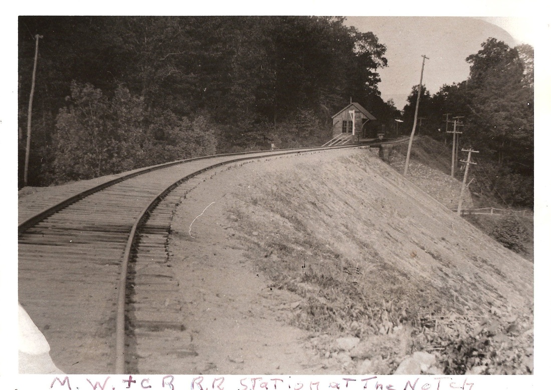
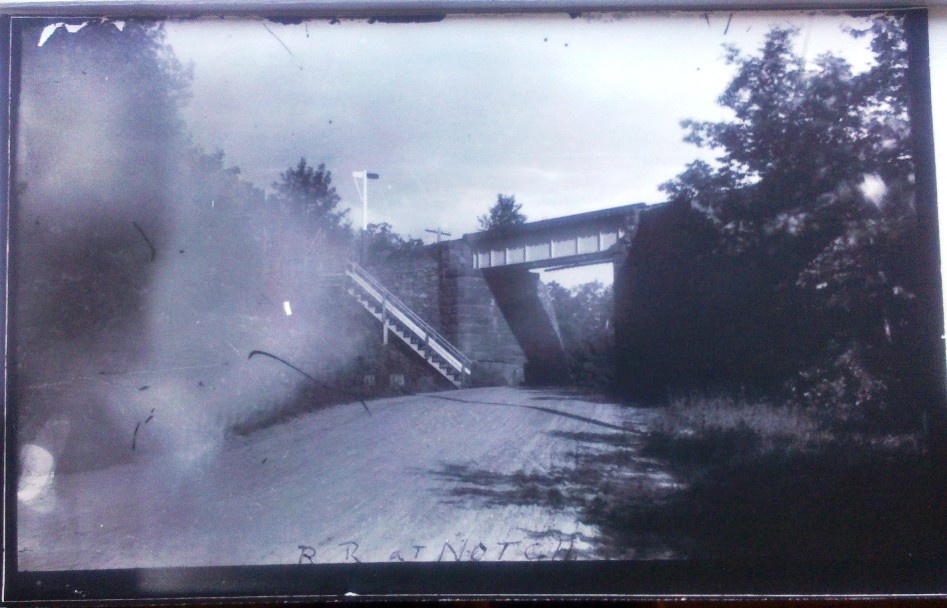
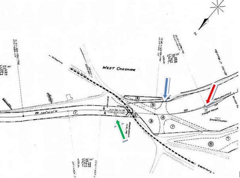
WEST CHESHIRE [M&W, 1888]
Later called TUCKER, this station stood high above today's Rte. 70, Cheshire's West Main St., at the junction of Rte. 68. The station was perched on the east cliff at The Notch, so-called for the break in the trap-rock ledge which allowed passage to the north and west. The ca. 1900 photo at upper left shows the station and platform at the top of the stairs that came up from the road. Also apparent is the huge amount of fill that the railroad dumped into The Notch to elevate the road bed. Snow dates the train photo at upper middle to ca. 1889, shortly after the M&W opened, with a consist rolling west out of the station. Looking through the underpass, you can see the bottom of the stairs. The street view at upper right likely dates to between 1900 and 1904 and looks east, since the tracks of the Cheshire Street Rwy, approved by the railroad commissioners on 8/7/1905, are not seen yet. It does show the bottom of the staircase and the train-signal pole by the track. The 8/30/1916 val photo at lower left is a close-up of the structure that seems identical to CHESHIRE STREET, SOUTHINGTON ROAD, and other depots on the line. Reflecting the 1917 discontinuance of rail passenger service, the photo at lower middle shows no stairs any more but does picture the trolley heading toward Waterbury, as it would do until 1934. The snippet from the 1915 val map [click here] at lower right shows the passenger station [green arrow], the freight depot and siding [red arrow], the dashed lines [blue arrow] marking the roads abandoned when the railroad filled in The Notch leaving only the narrow underpass where at least one trolley-automobile accident occurred in 1931. According to notes left by the late Nelson Tucker, whose family homestead at 1142 Tucker Rd. lay between the trolley and railroad ROWs, the renaming as TUCKER was due to mix-ups in freight and mail that came to the WEST CHESHIRE station on the MW&CR instead of to the CHESHIRE station on the Canal line. His family had no objection to the freight and passenger stations, as well as a trolley stop, named after them! Among his other reminiscences, which are found at the Cheshire Historical Society, was the fact that trains loaded with summer beach-goers returning to the Brass City from New Haven had to be separated by his house into sections to get home over Waterbury Mountain. Once the trolley line opened, this traffic shifted to the interurbans which, in turn, doomed the MW&CR. A 1918 highway map in our collection shows WEST CHESHIRE as TUCKER, a change we find occuring in timetables between 1914 and 1915. Rail passenger service ceased on 6/24/1917 and the station structure was reportedly sold after the ICC granted permission to abandon the line entirely on 2/25/1924. A photo in our collection gives 1886 and 1921 for the build and renaming dates and says this station was sold and removed in 1924, the latter date the only one we can agree with. [REFS: CRC53.1905.35; HC/03/19/1931/22; S26,27,30] [rev042013]
Later called TUCKER, this station stood high above today's Rte. 70, Cheshire's West Main St., at the junction of Rte. 68. The station was perched on the east cliff at The Notch, so-called for the break in the trap-rock ledge which allowed passage to the north and west. The ca. 1900 photo at upper left shows the station and platform at the top of the stairs that came up from the road. Also apparent is the huge amount of fill that the railroad dumped into The Notch to elevate the road bed. Snow dates the train photo at upper middle to ca. 1889, shortly after the M&W opened, with a consist rolling west out of the station. Looking through the underpass, you can see the bottom of the stairs. The street view at upper right likely dates to between 1900 and 1904 and looks east, since the tracks of the Cheshire Street Rwy, approved by the railroad commissioners on 8/7/1905, are not seen yet. It does show the bottom of the staircase and the train-signal pole by the track. The 8/30/1916 val photo at lower left is a close-up of the structure that seems identical to CHESHIRE STREET, SOUTHINGTON ROAD, and other depots on the line. Reflecting the 1917 discontinuance of rail passenger service, the photo at lower middle shows no stairs any more but does picture the trolley heading toward Waterbury, as it would do until 1934. The snippet from the 1915 val map [click here] at lower right shows the passenger station [green arrow], the freight depot and siding [red arrow], the dashed lines [blue arrow] marking the roads abandoned when the railroad filled in The Notch leaving only the narrow underpass where at least one trolley-automobile accident occurred in 1931. According to notes left by the late Nelson Tucker, whose family homestead at 1142 Tucker Rd. lay between the trolley and railroad ROWs, the renaming as TUCKER was due to mix-ups in freight and mail that came to the WEST CHESHIRE station on the MW&CR instead of to the CHESHIRE station on the Canal line. His family had no objection to the freight and passenger stations, as well as a trolley stop, named after them! Among his other reminiscences, which are found at the Cheshire Historical Society, was the fact that trains loaded with summer beach-goers returning to the Brass City from New Haven had to be separated by his house into sections to get home over Waterbury Mountain. Once the trolley line opened, this traffic shifted to the interurbans which, in turn, doomed the MW&CR. A 1918 highway map in our collection shows WEST CHESHIRE as TUCKER, a change we find occuring in timetables between 1914 and 1915. Rail passenger service ceased on 6/24/1917 and the station structure was reportedly sold after the ICC granted permission to abandon the line entirely on 2/25/1924. A photo in our collection gives 1886 and 1921 for the build and renaming dates and says this station was sold and removed in 1924, the latter date the only one we can agree with. [REFS: CRC53.1905.35; HC/03/19/1931/22; S26,27,30] [rev042013]

WEST CORNWALL1 [HRR, 1842]
Contrary to what has been believed traditionally, there was a first station here that burned mid-year in 1871. The location is seen on the 1854LC map. [REFS: CWN/11/03/1871/02]
Contrary to what has been believed traditionally, there was a first station here that burned mid-year in 1871. The location is seen on the 1854LC map. [REFS: CWN/11/03/1871/02]

|

|
|
WEST CORNWALL2 [HRR, 1871]
The newspaper said late in 1871 that the "depot at West Cornwall which this company have recently erected on the site of the one destroyed by fire a few months since, is certainly not only a neatly and substantially built depot, but the general arrangement of all its parts for convenience in doing the work of the station is commendable." The plans for the new structure were credited to long-time HRR station agent Crandall. WEST CORNWALL2 still stands in 2012. [REFS: CWN/11/03/1871/02]
The newspaper said late in 1871 that the "depot at West Cornwall which this company have recently erected on the site of the one destroyed by fire a few months since, is certainly not only a neatly and substantially built depot, but the general arrangement of all its parts for convenience in doing the work of the station is commendable." The plans for the new structure were credited to long-time HRR station agent Crandall. WEST CORNWALL2 still stands in 2012. [REFS: CWN/11/03/1871/02]
WEST CROMWELL [M&C, 1885]
This was a flag station on the M&C between WESTFIELD and CROMWELL in the town of the latter name. [REFS: HC/01/18/1899/11]
This was a flag station on the M&C between WESTFIELD and CROMWELL in the town of the latter name. [REFS: HC/01/18/1899/11]
|

|
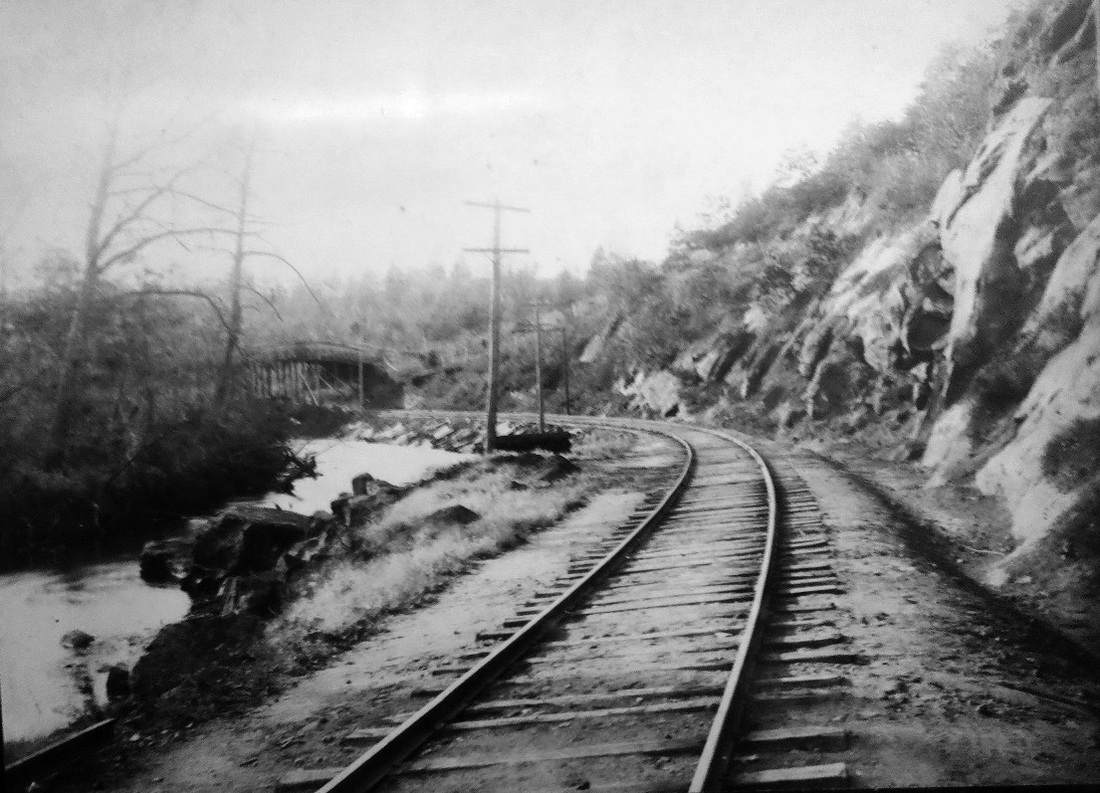
|

|
|
WEST HANOVER [NYNH&H, c1900?]
If there ever was an obscure location, this is it. Though we have yet to see it on any timetable, Snow has this MERIDEN stop on his map at upper left and the 1914 Connecticut Co. trolley map at upper right has it as well, though EAST HANOVER and WEST HANOVER seem to be reversed on the latter. The distant bridge over the track seen in the photo at lower left seems to correspond to the 1893 topo map at lower middle where our blue arrow points to a highway overpass. The val map at lower right does show a siding here but nothing more at that time and no indication of anything abandoned. There was manufacturing in this area, both at EAST HANOVER and CHESHIRE STREET, powered by small canals fed by the Quinnipiac River. WEST HANOVER seems to have been a lightly patronized, factory stop handled by conductor's order, as was the case with TORRINGFORD STREET. [rev042013]
If there ever was an obscure location, this is it. Though we have yet to see it on any timetable, Snow has this MERIDEN stop on his map at upper left and the 1914 Connecticut Co. trolley map at upper right has it as well, though EAST HANOVER and WEST HANOVER seem to be reversed on the latter. The distant bridge over the track seen in the photo at lower left seems to correspond to the 1893 topo map at lower middle where our blue arrow points to a highway overpass. The val map at lower right does show a siding here but nothing more at that time and no indication of anything abandoned. There was manufacturing in this area, both at EAST HANOVER and CHESHIRE STREET, powered by small canals fed by the Quinnipiac River. WEST HANOVER seems to have been a lightly patronized, factory stop handled by conductor's order, as was the case with TORRINGFORD STREET. [rev042013]

|

|
|
WEST HAVEN/M1 [NY&NH, 1848]
This seems to have been a flag stop from the opening of the NY&NH in December, 1848, with the first timetable listing that we find not until 6/2/1851. The structure looks not to have been cross-gabled like MILFORD1 or STRATFORD1, but was otherwise similar in appearance, with a street-side gable and board-and-batten siding. The photograph, likely dating to the 1870s or 1880s, shows a substantial addition, probably for freight, on the east end. The depot was located at what we know as the southeast corner of Wood St. and Washington Ave. opposite the West Haven Buckle Co., founded in 1853 and whose building still stands in 2012. The 1852NH map shows the depot at the red arrow, between today's Campbell Ave. [left] and First Ave. [right], with Washington Ave. not having been built yet. An 1895 article in the Register says that "the depot which formerly stood just east of Washington Avenue has been moved to a point about midway between Campbell Avenue and Washington Avenue, about 100 yards south [railroad west] of its former location," as part of the four-tracking improvements in 1895. It came as a surprise to us that the Consolidated would move a forty-year-old structure in the midst of all the new stations it was building at the time, but the article states the fact very clearly and it goes on to say that the railroad now owned pretty much all the property 30 feet both sides of the ROW from the West River meadows to here. Encountering "some hitch" in buying the buckle company land, it constructed an access road from Campbell Ave. to the new depot site. The 1911 railroad real estate map at right shows a footprint that includes the smaller wing on the east side of the station, thus verifying that it is WEST HAVEN1 in its new location. Another lucky news-article find, this one from 1914, tells us that "the station of the New York New Haven and Hartford railroad beside the eastbound tracks was burned with its contents today. The station building was a frame structure, comparatively small. It was built about 50 years ago. The fire is believed to have started from an overheated stove. The loss is estimated at about $4000." Thus the stage was set for the building of WEST HAVEN/M3 probably in mid-1914. [REFS: CR/03/17/1849/04; NHER/11/11/1895/06; HC/02/27/1914/16]
This seems to have been a flag stop from the opening of the NY&NH in December, 1848, with the first timetable listing that we find not until 6/2/1851. The structure looks not to have been cross-gabled like MILFORD1 or STRATFORD1, but was otherwise similar in appearance, with a street-side gable and board-and-batten siding. The photograph, likely dating to the 1870s or 1880s, shows a substantial addition, probably for freight, on the east end. The depot was located at what we know as the southeast corner of Wood St. and Washington Ave. opposite the West Haven Buckle Co., founded in 1853 and whose building still stands in 2012. The 1852NH map shows the depot at the red arrow, between today's Campbell Ave. [left] and First Ave. [right], with Washington Ave. not having been built yet. An 1895 article in the Register says that "the depot which formerly stood just east of Washington Avenue has been moved to a point about midway between Campbell Avenue and Washington Avenue, about 100 yards south [railroad west] of its former location," as part of the four-tracking improvements in 1895. It came as a surprise to us that the Consolidated would move a forty-year-old structure in the midst of all the new stations it was building at the time, but the article states the fact very clearly and it goes on to say that the railroad now owned pretty much all the property 30 feet both sides of the ROW from the West River meadows to here. Encountering "some hitch" in buying the buckle company land, it constructed an access road from Campbell Ave. to the new depot site. The 1911 railroad real estate map at right shows a footprint that includes the smaller wing on the east side of the station, thus verifying that it is WEST HAVEN1 in its new location. Another lucky news-article find, this one from 1914, tells us that "the station of the New York New Haven and Hartford railroad beside the eastbound tracks was burned with its contents today. The station building was a frame structure, comparatively small. It was built about 50 years ago. The fire is believed to have started from an overheated stove. The loss is estimated at about $4000." Thus the stage was set for the building of WEST HAVEN/M3 probably in mid-1914. [REFS: CR/03/17/1849/04; NHER/11/11/1895/06; HC/02/27/1914/16]

Dave Peters Collection
|

|
WEST HAVEN/M2 [NYNH&H, 1895]
This small structure was built on the westbound side in 1895 with the four-tracking as a companion to WEST HAVEN1 in its new location. Both of these photos look toward New Haven. WEST HAVEN/M2 is seen by itself in the 10/26/1916 val photo at left and across from WEST HAVEN/M3 in the photo on the right. [REFS: CRC42.1894.17; RHA 1928]
This small structure was built on the westbound side in 1895 with the four-tracking as a companion to WEST HAVEN1 in its new location. Both of these photos look toward New Haven. WEST HAVEN/M2 is seen by itself in the 10/26/1916 val photo at left and across from WEST HAVEN/M3 in the photo on the right. [REFS: CRC42.1894.17; RHA 1928]

Dave Peters Collection
|

C. Dunn Collection
|
WEST HAVEN/M3 [NYNH&H, 1914]
This station replaced WEST HAVEN1 on the eastbound side of the New York main line, 1914-1915. This was due to the burning of the old station on 2/26/1914, with the June, 1915 annual report mentioning that a new station has been built by that time. The 10/26/1916 val photo at left, therefore, must show this station when it was nearly brand new. This stop is still on our 1923TT but is gone on the 11/18/1928TT, the next one we have, and we do not know the final disposition of this station. It is on the 1938 SSRR list #1551 to be retired and removed but we have no subsequent information. We have seen a reference somewhere that locals wanted service restored to this community with the construction of the VA Hospital in the 1950s but that apparently never came to fruition. [REFS: NHAR44.1915.10; AFE 30280-6][rev010518]
This station replaced WEST HAVEN1 on the eastbound side of the New York main line, 1914-1915. This was due to the burning of the old station on 2/26/1914, with the June, 1915 annual report mentioning that a new station has been built by that time. The 10/26/1916 val photo at left, therefore, must show this station when it was nearly brand new. This stop is still on our 1923TT but is gone on the 11/18/1928TT, the next one we have, and we do not know the final disposition of this station. It is on the 1938 SSRR list #1551 to be retired and removed but we have no subsequent information. We have seen a reference somewhere that locals wanted service restored to this community with the construction of the VA Hospital in the 1950s but that apparently never came to fruition. [REFS: NHAR44.1915.10; AFE 30280-6][rev010518]
|
|
WEST HAVEN/M4 [MN, 2012]
Rail service is returning to West Haven after an absence of nearly a century, this time in the shadow of the Armstrong Rubber Co.'s defunct tire factory on Saw Mill Rd. Ground was broken on 11/10/2010 for a new station here, north of the tracks at Hood Terrace, formerly known as Railroad Ave., at a cost of over $100M. While we personally advocated for a smaller structure here and an additional stop on Marsh Hill Rd. in Orange that would have replicated the old Woodmont station, for a much smaller total price tag and convenience for more motorists, West Haven won the battle for the only station the state was willing to build at the time. Even then we don't know why these Taj Mahals have to to be put up, when simpler structures, adequate parking lots, AND, most importantly, dedicated peak-hour shuttle service would take the most automobiles off the road. At least train service is coming back and the 700 parking spaces should relieve some of the pressure at Union Station in New Haven where garage capacity has long been inadequate. WEST HAVEN5 is ahead of schedule and may be completed by August, 2013. [REFS: NHR/04/10/2010/??; NHR/11/10/2010/??][rev050013]
Rail service is returning to West Haven after an absence of nearly a century, this time in the shadow of the Armstrong Rubber Co.'s defunct tire factory on Saw Mill Rd. Ground was broken on 11/10/2010 for a new station here, north of the tracks at Hood Terrace, formerly known as Railroad Ave., at a cost of over $100M. While we personally advocated for a smaller structure here and an additional stop on Marsh Hill Rd. in Orange that would have replicated the old Woodmont station, for a much smaller total price tag and convenience for more motorists, West Haven won the battle for the only station the state was willing to build at the time. Even then we don't know why these Taj Mahals have to to be put up, when simpler structures, adequate parking lots, AND, most importantly, dedicated peak-hour shuttle service would take the most automobiles off the road. At least train service is coming back and the 700 parking spaces should relieve some of the pressure at Union Station in New Haven where garage capacity has long been inadequate. WEST HAVEN5 is ahead of schedule and may be completed by August, 2013. [REFS: NHR/04/10/2010/??; NHR/11/10/2010/??][rev050013]
|
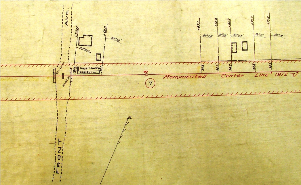
Archives & Special Collections, UConn Libraries
|
WEST HAVEN/D [NH&D, 1871]
This was the NH&D's 1871 station on Front St. in the Allingtown section of West Haven. The location is shown on the 1891 Price & Lee New Haven City Directory map at left. We have not yet found a photo of whatever stood here but there are several references to the structure which was vandalized and nearly destroyed in 1874. It should be noted that the rail line crossed on a bridge here and most likely the station was at street level with stairs up to the track. The real estate map at right shows stairs on the east end of an elevated platform. WEST HAVEN2 continued to be a flag stop at least until our 1911TT, but it was gone by that of 1914. [REFS: WHJ/04/01/1874/02; NHER/11/01/1883/03][rev042013]
This was the NH&D's 1871 station on Front St. in the Allingtown section of West Haven. The location is shown on the 1891 Price & Lee New Haven City Directory map at left. We have not yet found a photo of whatever stood here but there are several references to the structure which was vandalized and nearly destroyed in 1874. It should be noted that the rail line crossed on a bridge here and most likely the station was at street level with stairs up to the track. The real estate map at right shows stairs on the east end of an elevated platform. WEST HAVEN2 continued to be a flag stop at least until our 1911TT, but it was gone by that of 1914. [REFS: WHJ/04/01/1874/02; NHER/11/01/1883/03][rev042013]

|
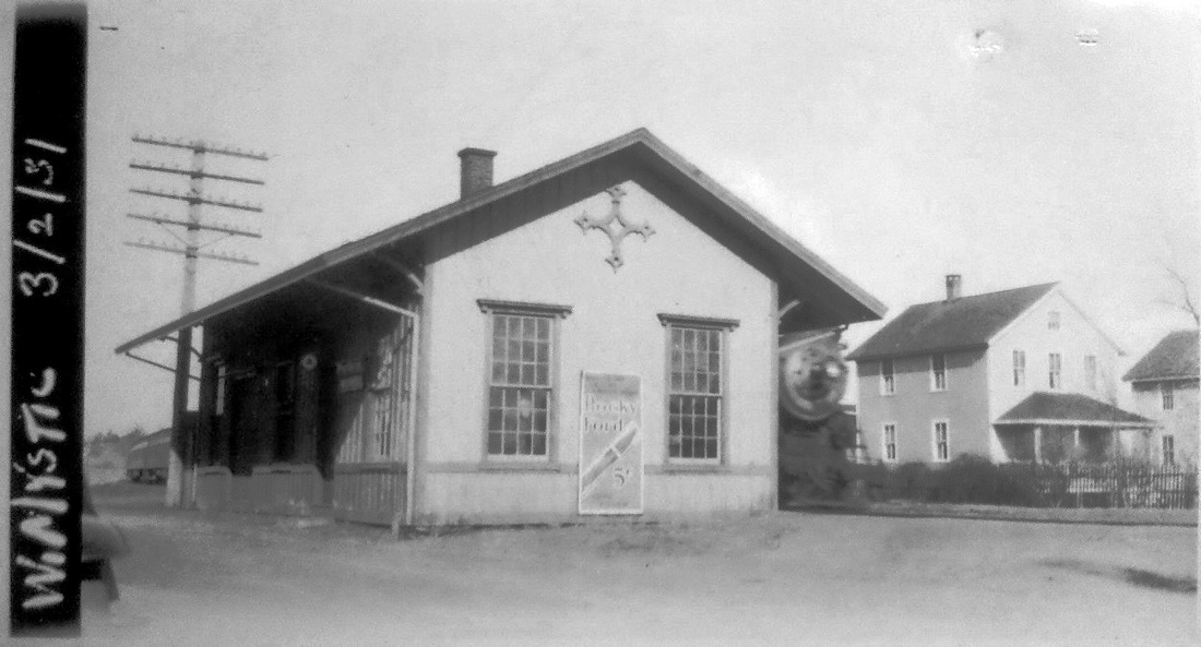
Dave Peters Collection
|

|

WEST MYSTIC [NL&S, 1858]
This station in the town of GROTON still wears the compass ornament that refers to the NYP&B period of ownership. Though the stop was established when the railroad opened on 12/30/1858, according to Carol Kimball in a New London Day article, the property for this station was not deeded until 4/20/1859 and the depot presumably was built by the middle of the year. This structure was for sale and looked to be in good condition for its age when we visited in May, 2010. It was moved across the tracks and turned 90 degrees, ca. 1938 after the hurricane according to John Roy, so it is now perpendicular to the Northeast Corridor which sees plenty of action every day. [REFS: NLD/02/24/1999/C6; R106][rev070113, 051519]
This station in the town of GROTON still wears the compass ornament that refers to the NYP&B period of ownership. Though the stop was established when the railroad opened on 12/30/1858, according to Carol Kimball in a New London Day article, the property for this station was not deeded until 4/20/1859 and the depot presumably was built by the middle of the year. This structure was for sale and looked to be in good condition for its age when we visited in May, 2010. It was moved across the tracks and turned 90 degrees, ca. 1938 after the hurricane according to John Roy, so it is now perpendicular to the Northeast Corridor which sees plenty of action every day. [REFS: NLD/02/24/1999/C6; R106][rev070113, 051519]
|
|
|
WEST NORFOLK1 [CW, 1871]
This station has long been a source of mystery and no pictures have been found thus far. It was a flag stop at the opening of the CW, and though we have found no actual mention of a depot being built, several newspaper articles show that this was soon an agency station handling passengers, freight and mail. An especially revealing 1875 article sheds a little light on the first depot here when it tells of the passing of an older gentleman, James C. Swift, while sitting in a chair in the waiting room. Upon hearing a noise, Agent Murphy returned from "the small apartment in which is his office" to find the man about to fall the floor and dead a few minutes later of an apoplectic fit. So thus we get some idea of a full-service station, which may also have been quite a bit busier than we thought since granite quarries, probably encouraged by the coming of the railroad, were reported as "recently opened" in 1874. A 14-ton block that was dressed to say 'Hoosac Tunnel, 1874' and destined to grace the western portal of that great project was taken from here. It required eight yoke of oxen, one pair in front of the block and the others on the rear, to get it down the "uninterrupted descent" of the steep mountainside. The railroad also took rock from a quarry at nearby Stony Lonesome for its own construction purposes. The NY&NE 1880 appraisal of CW properties said the structure here was in fair condition and valued it at $500, comparable to some 30x40-ft freight depots elsewhere. In 1891, the newspaper said that "the sale of tickets has been discontinued at West Norfolk station, and hereafter passenger trains will only stop there on a signal," and by the time it burned on 11/7/1896, the depot was said to be an "old and dilapidated structure and unoccupied." The 1871 map in the CW real estate atlas at [1] shows this station in the northwest quadrant of the diagonal grade crossing and indicates the subsequent renaming as HAYSTACK in pencil as well. Our red arrow on the 1874 map at [2] marks the depot location and at the blue arrow we also note the name 'E.T. Butler, likely Egbert T. Butler who was the foremost promoter of the CW. The water tank seen at [3] is the only image we have of any structure at this location. Said to be "one of the largest and best on the line," it was destroyed along with the station in the 1896 fire thought to have been started by tramps. It too had been valued at $500 in 1880. While Nimke said this tank stood at COLEBROOK, Lee Beaujon and Al Weaver concur that the location was here looking north from Ashpohtag Rd. Lee explains that the tank housing, thought to be unique on the CW, had a furnace on the lower level to keep the water from freezing at this high altitude. The shot at [4] shows a similar structure out of state. The consensus is that the train in the photo is heading railroad-west. The #5, the Norfolk, was an 1871 Rogers engine, thus giving from that year to 1896 as a date range for this photo. [REFS: HDC/12/21/1871/02; HDC/07/24/1874/02; CWN/08/21/1874/02; HDC/08/26/1874/02; CWN/08/28/1874/02; WH/10/02/1874/02; CWN/11/20/1874/02; CWN/10/08/ 1875/02; CWN/06/10/1891/04; WH/11/11/1896/08; C133; Fisher, SL, p124] [rev011715]
This station has long been a source of mystery and no pictures have been found thus far. It was a flag stop at the opening of the CW, and though we have found no actual mention of a depot being built, several newspaper articles show that this was soon an agency station handling passengers, freight and mail. An especially revealing 1875 article sheds a little light on the first depot here when it tells of the passing of an older gentleman, James C. Swift, while sitting in a chair in the waiting room. Upon hearing a noise, Agent Murphy returned from "the small apartment in which is his office" to find the man about to fall the floor and dead a few minutes later of an apoplectic fit. So thus we get some idea of a full-service station, which may also have been quite a bit busier than we thought since granite quarries, probably encouraged by the coming of the railroad, were reported as "recently opened" in 1874. A 14-ton block that was dressed to say 'Hoosac Tunnel, 1874' and destined to grace the western portal of that great project was taken from here. It required eight yoke of oxen, one pair in front of the block and the others on the rear, to get it down the "uninterrupted descent" of the steep mountainside. The railroad also took rock from a quarry at nearby Stony Lonesome for its own construction purposes. The NY&NE 1880 appraisal of CW properties said the structure here was in fair condition and valued it at $500, comparable to some 30x40-ft freight depots elsewhere. In 1891, the newspaper said that "the sale of tickets has been discontinued at West Norfolk station, and hereafter passenger trains will only stop there on a signal," and by the time it burned on 11/7/1896, the depot was said to be an "old and dilapidated structure and unoccupied." The 1871 map in the CW real estate atlas at [1] shows this station in the northwest quadrant of the diagonal grade crossing and indicates the subsequent renaming as HAYSTACK in pencil as well. Our red arrow on the 1874 map at [2] marks the depot location and at the blue arrow we also note the name 'E.T. Butler, likely Egbert T. Butler who was the foremost promoter of the CW. The water tank seen at [3] is the only image we have of any structure at this location. Said to be "one of the largest and best on the line," it was destroyed along with the station in the 1896 fire thought to have been started by tramps. It too had been valued at $500 in 1880. While Nimke said this tank stood at COLEBROOK, Lee Beaujon and Al Weaver concur that the location was here looking north from Ashpohtag Rd. Lee explains that the tank housing, thought to be unique on the CW, had a furnace on the lower level to keep the water from freezing at this high altitude. The shot at [4] shows a similar structure out of state. The consensus is that the train in the photo is heading railroad-west. The #5, the Norfolk, was an 1871 Rogers engine, thus giving from that year to 1896 as a date range for this photo. [REFS: HDC/12/21/1871/02; HDC/07/24/1874/02; CWN/08/21/1874/02; HDC/08/26/1874/02; CWN/08/28/1874/02; WH/10/02/1874/02; CWN/11/20/1874/02; CWN/10/08/ 1875/02; CWN/06/10/1891/04; WH/11/11/1896/08; C133; Fisher, SL, p124] [rev011715]
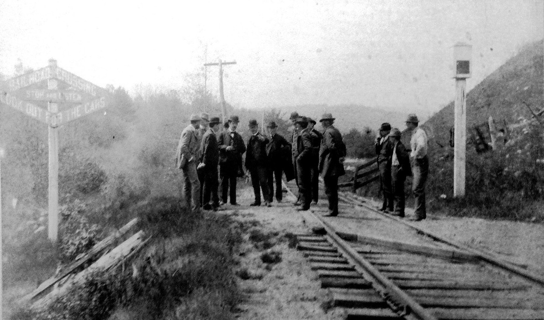
|
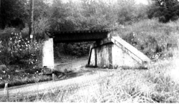
|
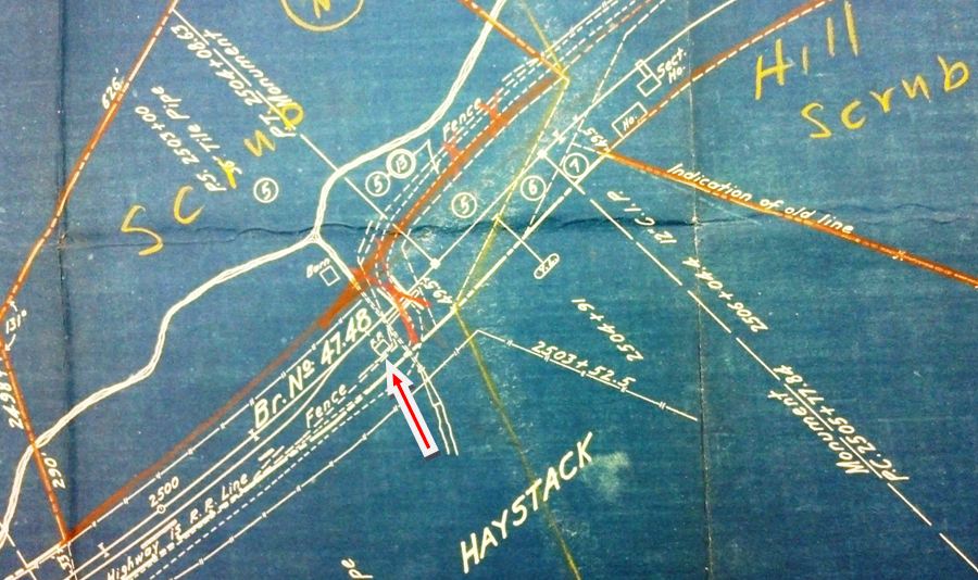
National Archives
|

National Archives
|

|
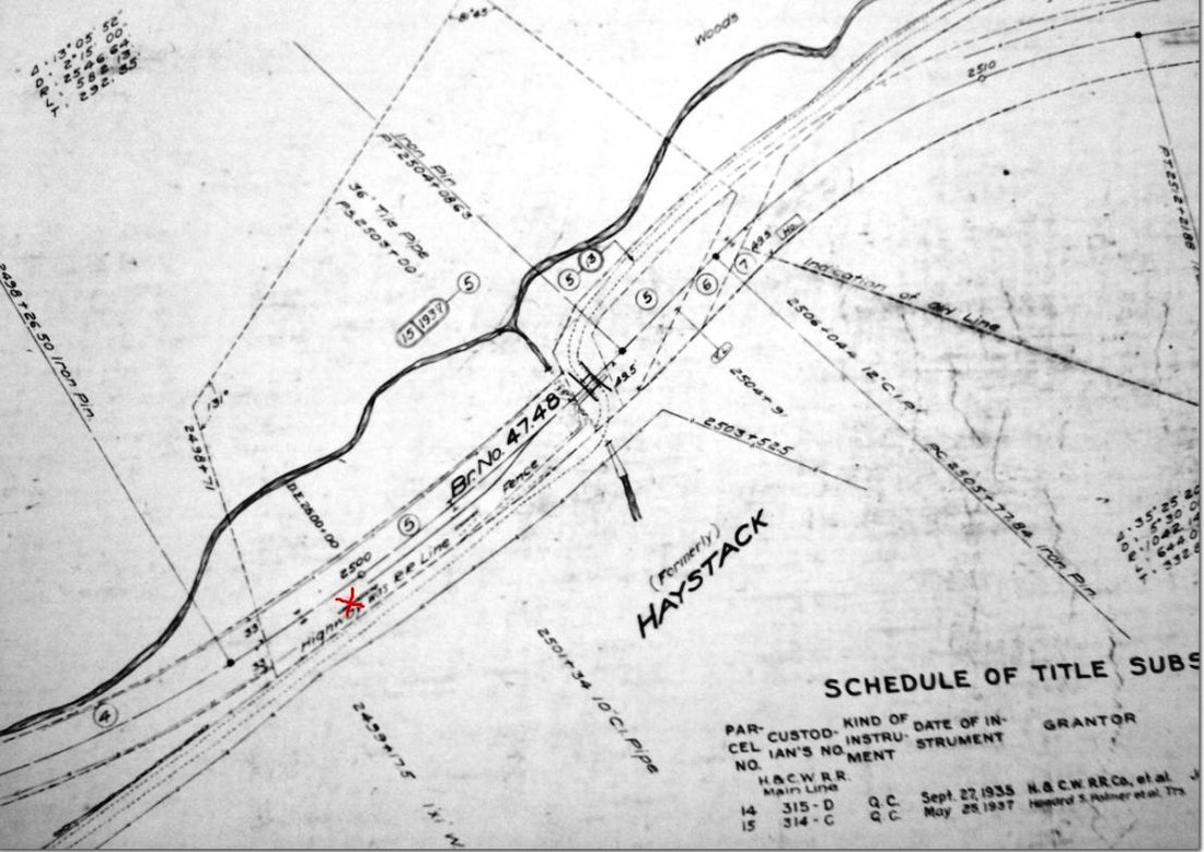
|
WEST NORFOLK2 [PR&NE, 1896]
After the first station burned, it was replaced but may not have been officially manned. Lee Beaujon says that ETTs started in 1905 to show agency stations with the D or N for day and night telegraph operators and those he has from 1905 until 1917 do not show any operator or telegraph code for here. That information, however, conflicts with a 1915 newspaper article that refers to a station agent, "who dispenses shoes and heavy hardware between trains and who is the recognized horseshoe pitching champ of that region between East Canaan and Doolittle pond..." We can only speculate that the railroad had an informal arrangement for a caretaker to look after the station on a part-time basis. The subject of the article is actually the changing of the station name and the newspaper quips that the 126 persons in West Norfolk would slumber on 6/5/1915 "only to wake up the next morning in Haystack. The rusty old sign on the depot will be missing, and a new one reading 'Haystack' will be there in gaudy gold letters. By that sign Haystackers will know their community has metamorphosed." This 'metamorphosis' was in advance compliance with the ICC directive eliminating station names that were duplicative and potentially confusing to train crews. After several bad accidents here, the dangerous grade crossing, probably being examined by the railroad commissioners at [1], would be eliminated in 1908 by the bridge, a westward view of which is seen at [2]. As best we can tell, this second depot stood more or less on the same spot as the earlier one. The 1916 val map at [3] is oriented with north on the left and shows the frame (wooden) passenger station ['FP'] standing above the overpass. The 10/29/1918 ICC field notes [4] value this 10'6"x15'6"x12-ft-high, tin-roofed station at $25; the 'gaudy gold-lettered' station sign itself was appraised at the tidy sum of $6.00! The shot at [5] looks north from the bridge over Ashpohtag Rd. and shows the 25-car passing siding on the left that Vic Newton says was installed around 1910. We note, however, that his otherwise fastidiously correct work has the siding south of Ashpohtag Rd. The 1938 abandonment map [6] shows this as 'formerly HAYSTACK' with the station gone. The removal of the bridge and the regrading of the road has obliterated much of the evidence of what stood here. What happened to the WEST NORFOLK2 structure is not known. [REFS: RRC16.347 (6/12/1906); HC/06/16/1906/15; CRC55.1907.47; CRC56 1908.52; ICC Ord. F-1611 (11/16/1915); SR/05/28/1915/04; N3.60][rev011715]
After the first station burned, it was replaced but may not have been officially manned. Lee Beaujon says that ETTs started in 1905 to show agency stations with the D or N for day and night telegraph operators and those he has from 1905 until 1917 do not show any operator or telegraph code for here. That information, however, conflicts with a 1915 newspaper article that refers to a station agent, "who dispenses shoes and heavy hardware between trains and who is the recognized horseshoe pitching champ of that region between East Canaan and Doolittle pond..." We can only speculate that the railroad had an informal arrangement for a caretaker to look after the station on a part-time basis. The subject of the article is actually the changing of the station name and the newspaper quips that the 126 persons in West Norfolk would slumber on 6/5/1915 "only to wake up the next morning in Haystack. The rusty old sign on the depot will be missing, and a new one reading 'Haystack' will be there in gaudy gold letters. By that sign Haystackers will know their community has metamorphosed." This 'metamorphosis' was in advance compliance with the ICC directive eliminating station names that were duplicative and potentially confusing to train crews. After several bad accidents here, the dangerous grade crossing, probably being examined by the railroad commissioners at [1], would be eliminated in 1908 by the bridge, a westward view of which is seen at [2]. As best we can tell, this second depot stood more or less on the same spot as the earlier one. The 1916 val map at [3] is oriented with north on the left and shows the frame (wooden) passenger station ['FP'] standing above the overpass. The 10/29/1918 ICC field notes [4] value this 10'6"x15'6"x12-ft-high, tin-roofed station at $25; the 'gaudy gold-lettered' station sign itself was appraised at the tidy sum of $6.00! The shot at [5] looks north from the bridge over Ashpohtag Rd. and shows the 25-car passing siding on the left that Vic Newton says was installed around 1910. We note, however, that his otherwise fastidiously correct work has the siding south of Ashpohtag Rd. The 1938 abandonment map [6] shows this as 'formerly HAYSTACK' with the station gone. The removal of the bridge and the regrading of the road has obliterated much of the evidence of what stood here. What happened to the WEST NORFOLK2 structure is not known. [REFS: RRC16.347 (6/12/1906); HC/06/16/1906/15; CRC55.1907.47; CRC56 1908.52; ICC Ord. F-1611 (11/16/1915); SR/05/28/1915/04; N3.60][rev011715]
WEST REDDING [> REDDING]
WEST SIMSBURY [> STRATTON BROOK]
WEST SIMSBURY [> STRATTON BROOK]
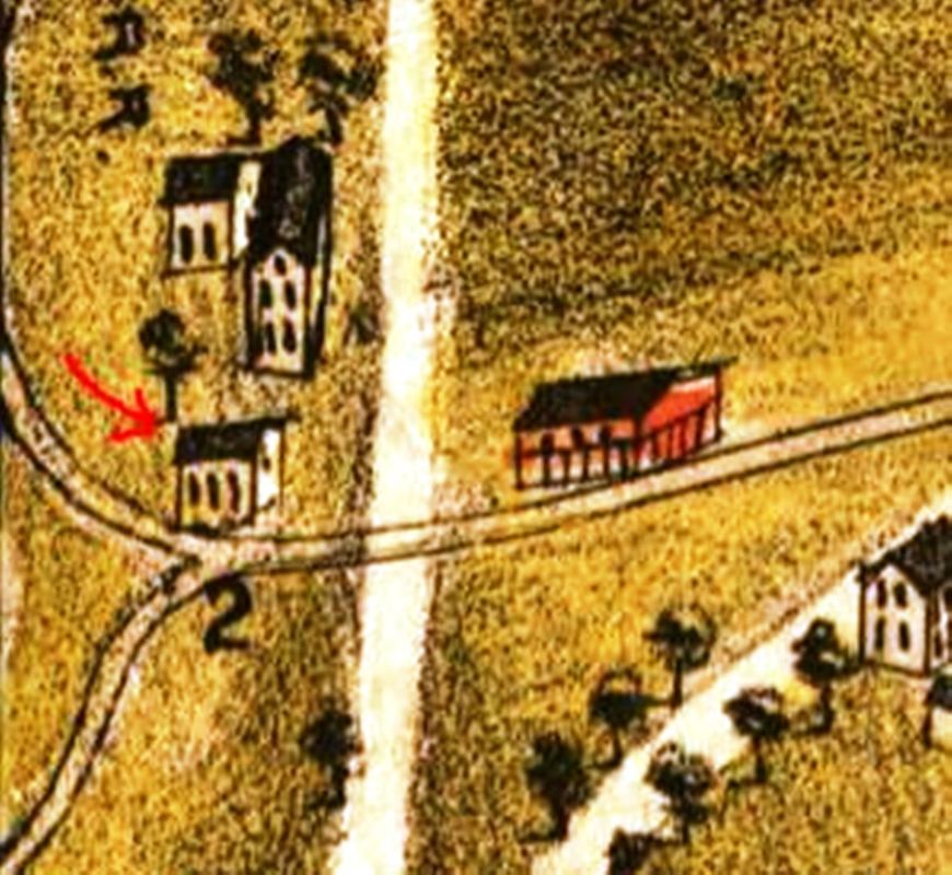
|

|
|
WEST STREET [RRR, 1863?]
Also called VERNON JUNCTION, WESTWAY. This station in the town of VERNON was on the Rockville RR, which opened from VERNON to ROCKVILLE in 1863. Inasmuch as this line was built for through connections to Hartford, we do not know exactly when this stop was established, but it shows up on an NY&NE timetable by 1873 and it later became the end point for the Connecticut Central's 1876 line from MELROSE. As early as 1865, a survey that anticipated the CC for a line connecting Rockville directly with Springfield via Ellington and Somers was made to a point called GIFFORDS, which may have been here. The small structure at locator number '2' on the 1877 Bailey map at [1] seems to be the most precise indicator of what the depot looked like and where it was. The image at [2] is from the 1895 Bailey map of Rockville and the map at right is ca. 1900. On both of these, it is difficult to determine exactly which building is the depot. This station would host electric cars on both tracks from 1906, to 1914 on the Melrose line and until 1924 on the line from Burnside to Rockville. Karr says all passenger service ended here ca. 1929. [REFS: HDC/05/15/1865/02: Giffords; K84; SL13.2.28][rev121817]
Also called VERNON JUNCTION, WESTWAY. This station in the town of VERNON was on the Rockville RR, which opened from VERNON to ROCKVILLE in 1863. Inasmuch as this line was built for through connections to Hartford, we do not know exactly when this stop was established, but it shows up on an NY&NE timetable by 1873 and it later became the end point for the Connecticut Central's 1876 line from MELROSE. As early as 1865, a survey that anticipated the CC for a line connecting Rockville directly with Springfield via Ellington and Somers was made to a point called GIFFORDS, which may have been here. The small structure at locator number '2' on the 1877 Bailey map at [1] seems to be the most precise indicator of what the depot looked like and where it was. The image at [2] is from the 1895 Bailey map of Rockville and the map at right is ca. 1900. On both of these, it is difficult to determine exactly which building is the depot. This station would host electric cars on both tracks from 1906, to 1914 on the Melrose line and until 1924 on the line from Burnside to Rockville. Karr says all passenger service ended here ca. 1929. [REFS: HDC/05/15/1865/02: Giffords; K84; SL13.2.28][rev121817]
WEST SUFFIELD1 [CNE, 1900]
R&LHS papers at the Baker Library include a 12/29/1899 voucher for payment of $1,470 to Beers & Trafford, Millerton, NY contractors, for a station at WEST SUFFIELD plus one at FEEDING HILLS for an equal amount. The latter station is pictured in this val photo that was probably taken in 1916. Based on the fact this structure is substantially smaller than the depot in our next listing, we have borrowed this as an entry for WEST SUFFIELD1. A newspaper reporter riding the line on the opening of the Springfield branch in August, 1902 in fact says that "the little stations at Feeding Hills and West Suffield were passed without a stop..." and we are taking that as further evidence of the diminutive size and the similar appearance of both. Fire is the usual suspect when a depot disappears but we have found no mention, other than the railroad commissioners saying in December, 1903 that "new station buildings have been erected at Tariffville, East Granby, and Suffield on the Springfield branch..." [REFS: SR/08/03/1902/05; HC/10/20/1902/12; CRC51.1903.22][rev020917]
R&LHS papers at the Baker Library include a 12/29/1899 voucher for payment of $1,470 to Beers & Trafford, Millerton, NY contractors, for a station at WEST SUFFIELD plus one at FEEDING HILLS for an equal amount. The latter station is pictured in this val photo that was probably taken in 1916. Based on the fact this structure is substantially smaller than the depot in our next listing, we have borrowed this as an entry for WEST SUFFIELD1. A newspaper reporter riding the line on the opening of the Springfield branch in August, 1902 in fact says that "the little stations at Feeding Hills and West Suffield were passed without a stop..." and we are taking that as further evidence of the diminutive size and the similar appearance of both. Fire is the usual suspect when a depot disappears but we have found no mention, other than the railroad commissioners saying in December, 1903 that "new station buildings have been erected at Tariffville, East Granby, and Suffield on the Springfield branch..." [REFS: SR/08/03/1902/05; HC/10/20/1902/12; CRC51.1903.22][rev020917]
Tom Hassenmayer Collection
|

|

|
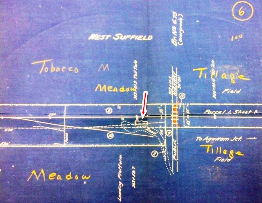
ICC / National Archives
WEST SUFFIELD2 [CNE, 1903]
Nimke says this station, still standing in 1930, was built in 1901 but the railroad commissioners say in their 1903 report that a depot was built during the year at "Suffield on the Springfield branch." With its increased length and height, freight wing and operator's bay, we think it not likely that it was built for $1,470 and, moreover, that it is also unlikely that the earlier station was remodeled. Either the old one burned or was sold to make way for a larger WEST SUFFIELD2 that was needed to handle business on the newly opened branch. The depot footprint is seen at the red arrow on the 1916 ICC val map. The handwritten notations on the 1938 SSRR list are difficult to decipher but seem to say this structure was sold on 7/2/1938 to an L.V. Viets, a surname well known in this and other nearby towns. The further fate of the building is unknown at this time. [REFS: CRC51.1903.22; HC/11/14/1903/05; D53; N3.15][rev010518]
Nimke says this station, still standing in 1930, was built in 1901 but the railroad commissioners say in their 1903 report that a depot was built during the year at "Suffield on the Springfield branch." With its increased length and height, freight wing and operator's bay, we think it not likely that it was built for $1,470 and, moreover, that it is also unlikely that the earlier station was remodeled. Either the old one burned or was sold to make way for a larger WEST SUFFIELD2 that was needed to handle business on the newly opened branch. The depot footprint is seen at the red arrow on the 1916 ICC val map. The handwritten notations on the 1938 SSRR list are difficult to decipher but seem to say this structure was sold on 7/2/1938 to an L.V. Viets, a surname well known in this and other nearby towns. The further fate of the building is unknown at this time. [REFS: CRC51.1903.22; HC/11/14/1903/05; D53; N3.15][rev010518]
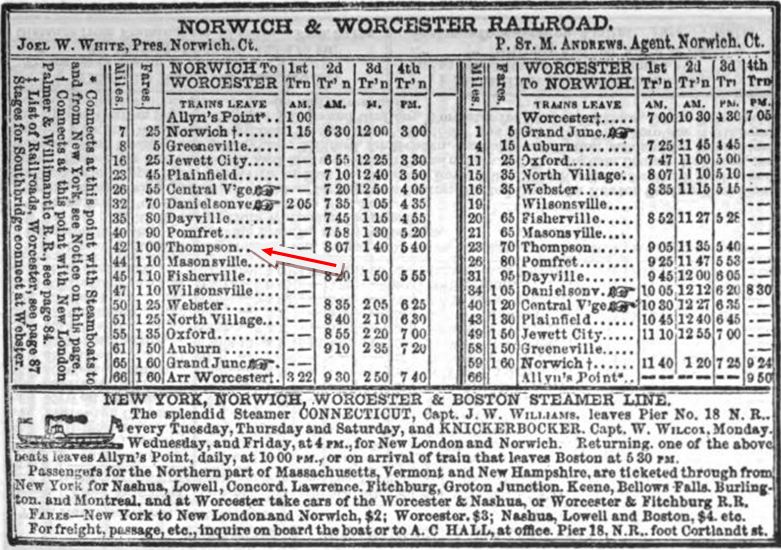
|
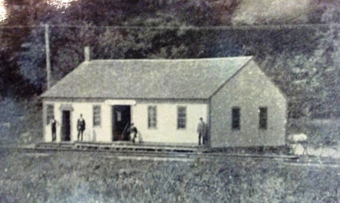
Thompson Historical Society
|

|
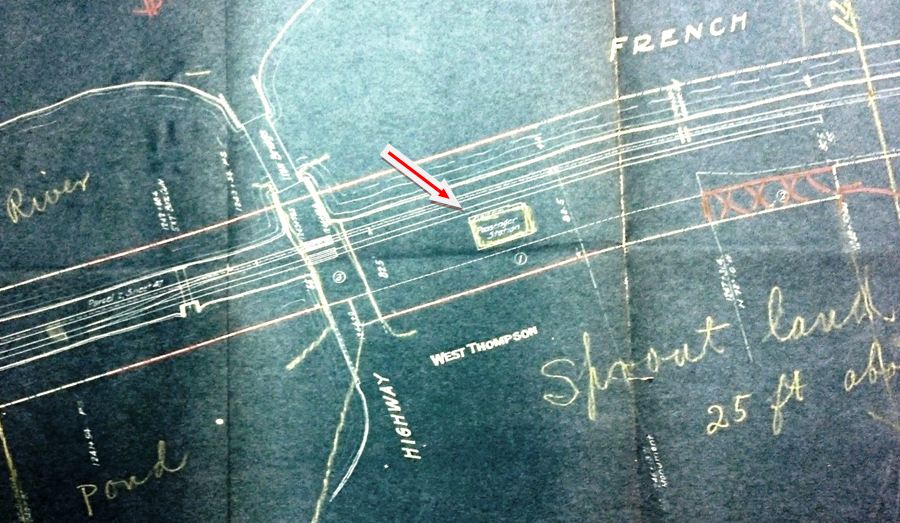
National Archives
|
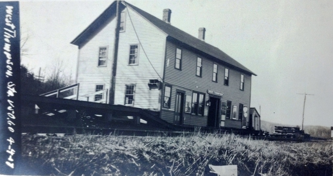
National Archives
|
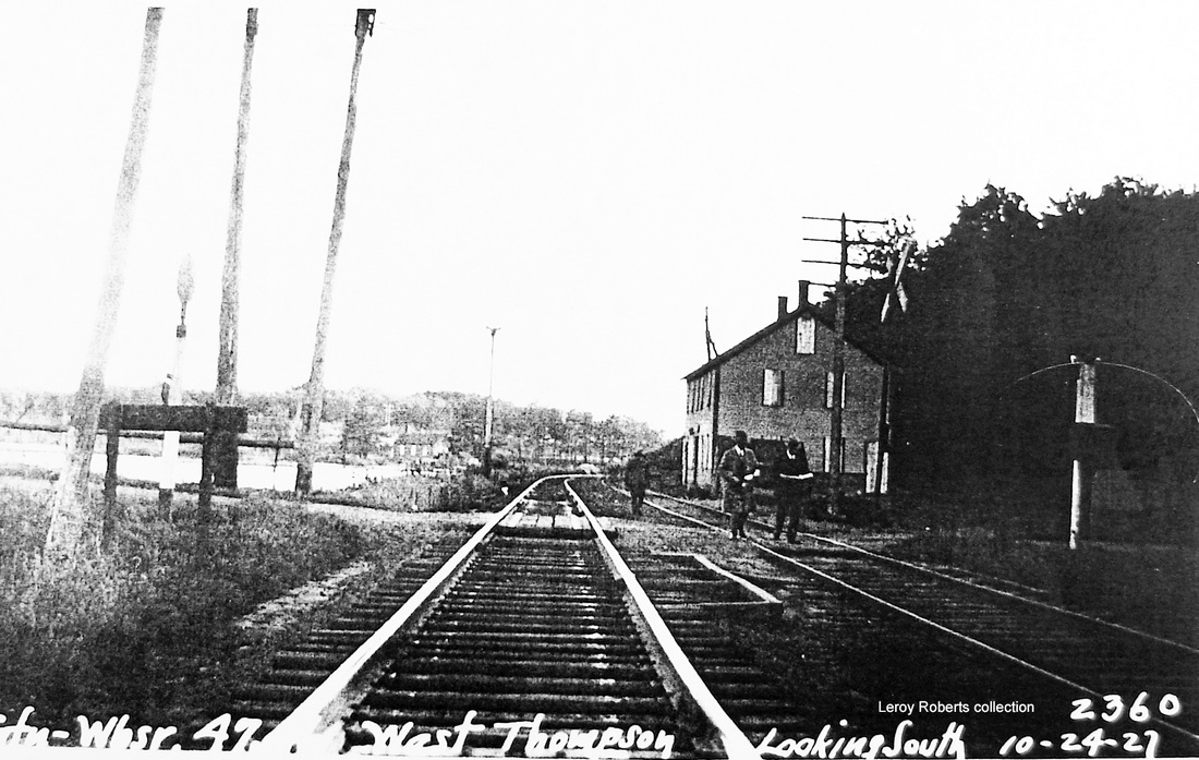
Max Miller Collection
|
WEST THOMPSON [N&W, 1840; opened as THOMPSON]
The N&W opened its line in 1840 and this probably was an original stop. The first timetable we have showing it is 1851 and is seen at upper left where it is called THOMPSON. The renaming probably came as a result of the 1869 lease of the N&W by the BH&E so as to differentiate between the stop on the line to Boston. Still, there is no change in the 1871 Pathfinder listings but the stop does show as WEST THOMPSON by 1875. Originally, this was a one-story structure [upper middle] but, according to the Thompson Historical Society [click here], a second story was added at some point for the stationmaster to live upstairs. The shot at upper right is a Louis H. Benton. The #819 would put it late in 1915, the same year as the val map at lower left. The val photo at lower middle is dated 4/4/1917. The shot at lower right looks south and shows the PUC examining the crossing on the middle is. [REFS: PTH380.1871.11; PTH18/20.1875.13][rev070813]
The N&W opened its line in 1840 and this probably was an original stop. The first timetable we have showing it is 1851 and is seen at upper left where it is called THOMPSON. The renaming probably came as a result of the 1869 lease of the N&W by the BH&E so as to differentiate between the stop on the line to Boston. Still, there is no change in the 1871 Pathfinder listings but the stop does show as WEST THOMPSON by 1875. Originally, this was a one-story structure [upper middle] but, according to the Thompson Historical Society [click here], a second story was added at some point for the stationmaster to live upstairs. The shot at upper right is a Louis H. Benton. The #819 would put it late in 1915, the same year as the val map at lower left. The val photo at lower middle is dated 4/4/1917. The shot at lower right looks south and shows the PUC examining the crossing on the middle is. [REFS: PTH380.1871.11; PTH18/20.1875.13][rev070813]

WEST WILLINGTON1 [NLW&P, 1850]
This stop, which is in the town of Willington, was first called TOLLAND AND WILLINGTON and is found as such on a 12/3/1866 NLN timetable. We have another copy of this photo that says it is from the 1890s, indicating that the changing of the station name to just TOLLAND and still later to WEST WILLINGTON came afterward, perhaps in the early 1900s when it is seen as such on a 6/24/1900 CVT timetable. Woodward says the brick combination station seen here was authorized by the NLW&P directors in 1850 at a cost of $1,700. This depot burned and was replaced in 1894 by the one in the next listing. Interestingly, the end brackets are very similar to NORWICH1 on the N&W. [REFS: CRC42.1894.24; R106; W37]
This stop, which is in the town of Willington, was first called TOLLAND AND WILLINGTON and is found as such on a 12/3/1866 NLN timetable. We have another copy of this photo that says it is from the 1890s, indicating that the changing of the station name to just TOLLAND and still later to WEST WILLINGTON came afterward, perhaps in the early 1900s when it is seen as such on a 6/24/1900 CVT timetable. Woodward says the brick combination station seen here was authorized by the NLW&P directors in 1850 at a cost of $1,700. This depot burned and was replaced in 1894 by the one in the next listing. Interestingly, the end brackets are very similar to NORWICH1 on the N&W. [REFS: CRC42.1894.24; R106; W37]

|

|
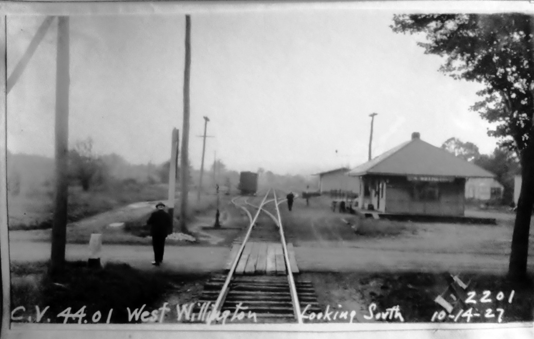
Max Miller Collection
|
WEST WILLINGTON2 [CVT, 1894]
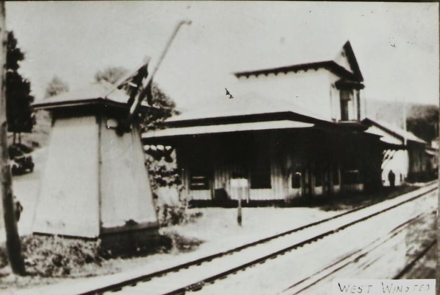
|
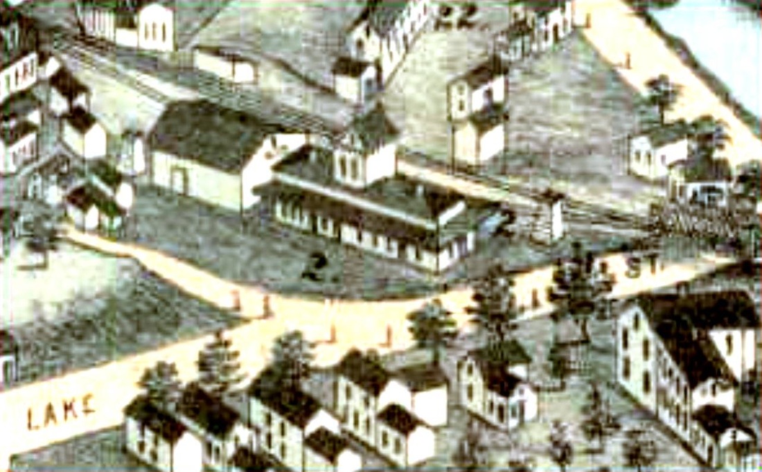
|
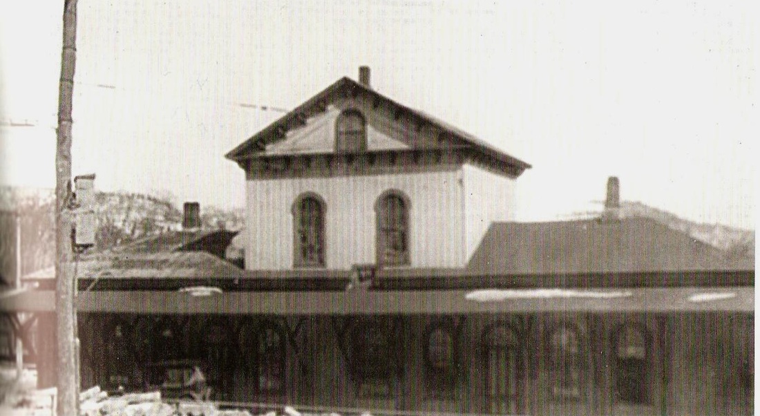
NHRHTA Collection
|

Dave Peters Collection
WEST WINSTED [CW, 1872]
This CW station was just about three quarters of mile west of downtown. On the map shot, note that the eagle-eyed artist even captured the unique, trapezoidal water tower that was just east of the depot that was located south of the track. According to Bob Adams, a donation of land by George Dudley in June, 1872 and the underwriting of costs by him and others brought this station about. An article in the Winsted Herald said it was to be fully occupied in early July. The 80x22-ft building is described as "very elegant and commodious," with an 8-ft wide platform running around it, "covered with a roof supported by braces very neatly formed and trimmed." Inside, the ticket office occupied the center, with gents and ladies rooms on either side and baggage rooms and freight office on the ends of the building. Above the central portion, there was a 22x25 second story intended as the agent's residence. The building was said to be painted with a handsome shade of light brown and trimmed with a darker shade. The 1880 NY&NE appraisal of CW properties said this two-story structure was worth a whopping $2,150, the most of any of its buildings. The depot served its purpose until 1905 when the NYNH&H abandoned all the town's CNE stations and thereafter just used the NRR's center of town depot, our WINSTED/N2. WEST WINSTED remained in railroad service thereafter and a photo in Nimke shows it still standing in 1927. It reportedly was torn down on 3/29/1929. [REFS: WH/06/21/1872/04; HDC08/16/1872/02; RRC16.334 (8/3/1905); D31; N3.49][rev032115, 121222]
This CW station was just about three quarters of mile west of downtown. On the map shot, note that the eagle-eyed artist even captured the unique, trapezoidal water tower that was just east of the depot that was located south of the track. According to Bob Adams, a donation of land by George Dudley in June, 1872 and the underwriting of costs by him and others brought this station about. An article in the Winsted Herald said it was to be fully occupied in early July. The 80x22-ft building is described as "very elegant and commodious," with an 8-ft wide platform running around it, "covered with a roof supported by braces very neatly formed and trimmed." Inside, the ticket office occupied the center, with gents and ladies rooms on either side and baggage rooms and freight office on the ends of the building. Above the central portion, there was a 22x25 second story intended as the agent's residence. The building was said to be painted with a handsome shade of light brown and trimmed with a darker shade. The 1880 NY&NE appraisal of CW properties said this two-story structure was worth a whopping $2,150, the most of any of its buildings. The depot served its purpose until 1905 when the NYNH&H abandoned all the town's CNE stations and thereafter just used the NRR's center of town depot, our WINSTED/N2. WEST WINSTED remained in railroad service thereafter and a photo in Nimke shows it still standing in 1927. It reportedly was torn down on 3/29/1929. [REFS: WH/06/21/1872/04; HDC08/16/1872/02; RRC16.334 (8/3/1905); D31; N3.49][rev032115, 121222]

Dave Peters Collection
|

|
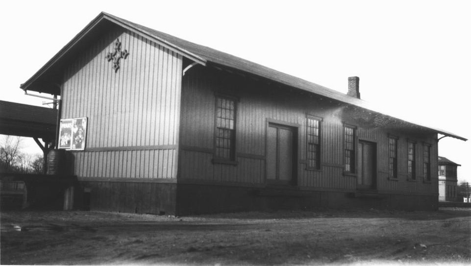
J.J. Harness Collection, NHRHTA
|
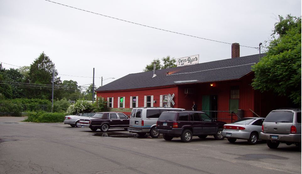
WESTBROOK1 [NH&NL, 1852]
Two views in a 1916 valuation photo at left and a 3/19/1930 val photo on the right. The depot location, north of the track, is shown on the 1859MC map. This wooden, combination station was built in 1852 by the NH&NL and wore the distinctive compass emblem that the NYP&B affixed when it leased the line from 1858 to 1862. Used for freight after WESTBROOK2 was built, it still stands in 2019, moved away from the tracks and turned 45 degrees from its original position. The recent photo at lower right shows it as it appears today with the rail line in the distance. [REFS: R107]
Two views in a 1916 valuation photo at left and a 3/19/1930 val photo on the right. The depot location, north of the track, is shown on the 1859MC map. This wooden, combination station was built in 1852 by the NH&NL and wore the distinctive compass emblem that the NYP&B affixed when it leased the line from 1858 to 1862. Used for freight after WESTBROOK2 was built, it still stands in 2019, moved away from the tracks and turned 45 degrees from its original position. The recent photo at lower right shows it as it appears today with the rail line in the distance. [REFS: R107]
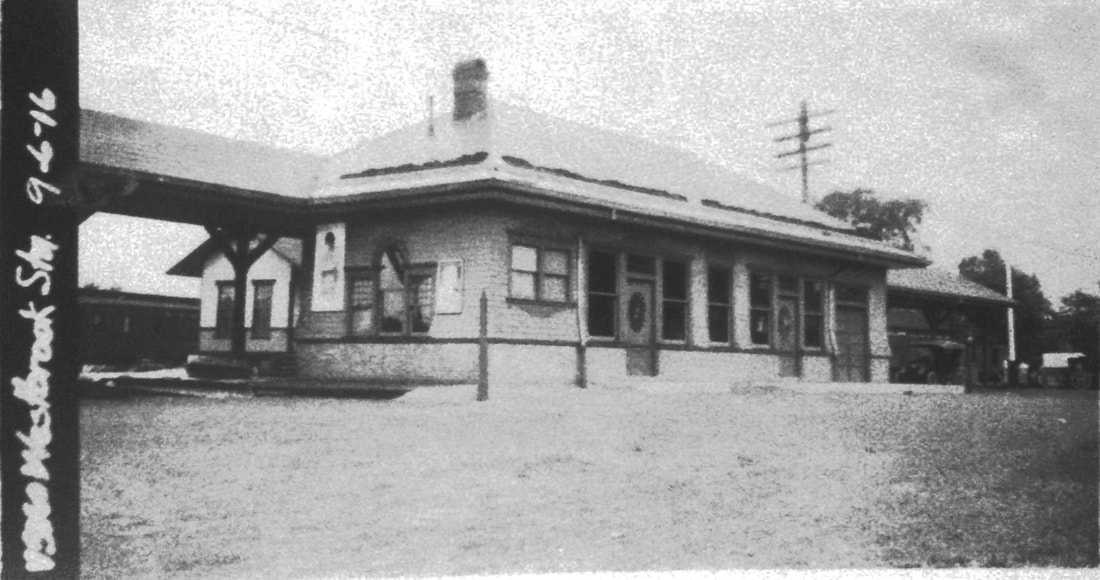
|

|

|
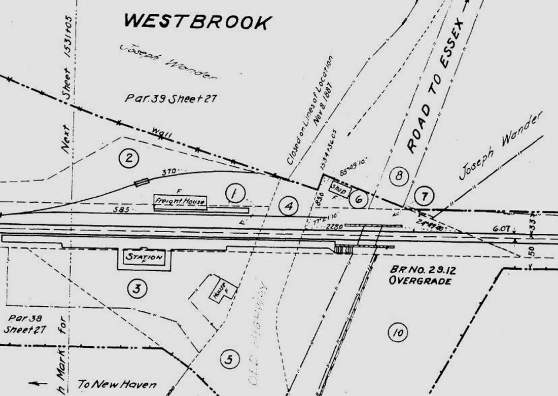
WESTBROOK2 [NYNH&H, 1906]
The val photo at [1] is dated 9/06/1916, ten years after this station was built and shows the street side of the depot. The shot at [2] is Lewis H. Benton #2835 taken on a foggy day in 1930; fellow photographer Irving Drake's car is to the left. This view looks west and shows the new station on the south side of the track with WESTBROOK1 on the north side and SS-96 tower in the distance. The undated image at [3] shows the front dormer that gave this otherwise unremarkable hip-roofed station a bit of class. At [4] is the 1915 val map. The Courant crowed enthusiastically in 1906 that "the new station is a beauty!" and gave a detailed description. It remarked about the low slanting roof, long coversheds and dark green exterior over a foundation of pressed brick. The old "barnlike" building, it said, was now being used for freight. Ironically, as John Roy points out, the old station has outlived the newer one. We do not yet know the fate of WESTBROOK2. Service was discontinued in April, 1936, according to a letter from the NYNH&H, then in bankruptcy proceedings, asking approval from the PUC on 12/13/1936. According to a 1938 Middletown Press, article, local riders had to catch trains thereafter at CLINTON or OLD SAYBROOK. The depot had been moved away from the track and in 1938 the railroad was looking to formally abandon this as a passenger stop. The SSRR list of that year shows this station as retired and to be disposed of. Ultimately it may have succumbed to the hurricane of 1938 that doomed BRANFORD3. Celebrity note: Trains made an occasional stop almost midway between WESTBROOK and GROVE BEACH so that Eleanor Roosevelt could de-train in the late 1940s and the 1950s and walk to her log cabin-style cottage at Salt Meadow. The property was owned by fellow activist Esther Lape who later donated the property, the first federal conservation area in the state, which is today the headquarters of the Stewart B. McKinney National Wildlife Refuge. [REFS: CRC53.1905.5; NHAR34.1905.7; HC/07/07/1906/02; MP/09/13/1938/10; R107][rev010518, 041519]
The val photo at [1] is dated 9/06/1916, ten years after this station was built and shows the street side of the depot. The shot at [2] is Lewis H. Benton #2835 taken on a foggy day in 1930; fellow photographer Irving Drake's car is to the left. This view looks west and shows the new station on the south side of the track with WESTBROOK1 on the north side and SS-96 tower in the distance. The undated image at [3] shows the front dormer that gave this otherwise unremarkable hip-roofed station a bit of class. At [4] is the 1915 val map. The Courant crowed enthusiastically in 1906 that "the new station is a beauty!" and gave a detailed description. It remarked about the low slanting roof, long coversheds and dark green exterior over a foundation of pressed brick. The old "barnlike" building, it said, was now being used for freight. Ironically, as John Roy points out, the old station has outlived the newer one. We do not yet know the fate of WESTBROOK2. Service was discontinued in April, 1936, according to a letter from the NYNH&H, then in bankruptcy proceedings, asking approval from the PUC on 12/13/1936. According to a 1938 Middletown Press, article, local riders had to catch trains thereafter at CLINTON or OLD SAYBROOK. The depot had been moved away from the track and in 1938 the railroad was looking to formally abandon this as a passenger stop. The SSRR list of that year shows this station as retired and to be disposed of. Ultimately it may have succumbed to the hurricane of 1938 that doomed BRANFORD3. Celebrity note: Trains made an occasional stop almost midway between WESTBROOK and GROVE BEACH so that Eleanor Roosevelt could de-train in the late 1940s and the 1950s and walk to her log cabin-style cottage at Salt Meadow. The property was owned by fellow activist Esther Lape who later donated the property, the first federal conservation area in the state, which is today the headquarters of the Stewart B. McKinney National Wildlife Refuge. [REFS: CRC53.1905.5; NHAR34.1905.7; HC/07/07/1906/02; MP/09/13/1938/10; R107][rev010518, 041519]
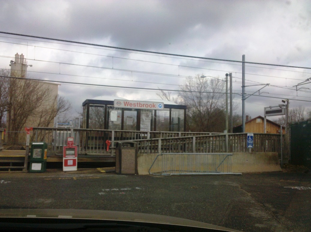
WESTBROOK3 SLE, 1990]
Small plexiglass shelter that has served here since 5/29/1990 for Shore Line East. Construction activity for WESTBROOK4 is in the works. In the upper right corner of this shot, you can see the south end of WESTBROOK1 on the north side of the tracks. [REFS: RP2013.6.34]
Small plexiglass shelter that has served here since 5/29/1990 for Shore Line East. Construction activity for WESTBROOK4 is in the works. In the upper right corner of this shot, you can see the south end of WESTBROOK1 on the north side of the tracks. [REFS: RP2013.6.34]
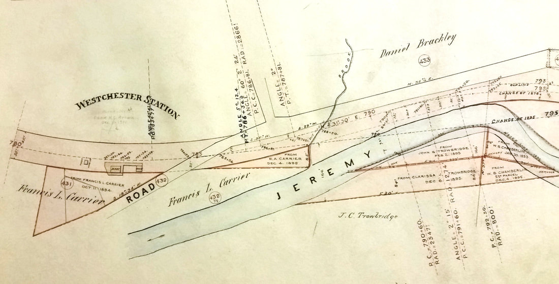 New Haven Museum
WESTCHESTER1 [NHM&W, 1873]
This station in the town of Colchester was established by the NHM&W when it opened in 1873. We have no photos yet of the first station but the 1888 Index Map shows the minimal size, its location south of the track and the arrangement of the grounds at that time. Note the small square Tank and its position. Both would be replaced by much larger structures, as seen in the next listing. The newspaper said that North Westchester, as this location was known, had been made a "postal station" with Lucius A. Carrier the postmaster. The railroads did carry the mail in the day and it was very common to have the post office at the railway depot with the stationmaster wearing both hats. Here the post office was reportedly first in a Carrier home and later at the village store the family operated. The Carrier name harkens back to the first settlers of the village in 1729. Notice that the owner of the property which the railroad used here was also surnamed Carrier. This would not be the first time for a quid pro quo! According to CATR, fire took the depot sometime after 1885 and a box car was used for some period of time before the station in the next listing was built. [REFS: MDC/09/27/1873/02; HC/12/07/1947/SM4; CATR, 1977: "Colchester and the Railroad," Charbonnier et al., Colchester Historical Society Collections][rev122921]
This station in the town of Colchester was established by the NHM&W when it opened in 1873. We have no photos yet of the first station but the 1888 Index Map shows the minimal size, its location south of the track and the arrangement of the grounds at that time. Note the small square Tank and its position. Both would be replaced by much larger structures, as seen in the next listing. The newspaper said that North Westchester, as this location was known, had been made a "postal station" with Lucius A. Carrier the postmaster. The railroads did carry the mail in the day and it was very common to have the post office at the railway depot with the stationmaster wearing both hats. Here the post office was reportedly first in a Carrier home and later at the village store the family operated. The Carrier name harkens back to the first settlers of the village in 1729. Notice that the owner of the property which the railroad used here was also surnamed Carrier. This would not be the first time for a quid pro quo! According to CATR, fire took the depot sometime after 1885 and a box car was used for some period of time before the station in the next listing was built. [REFS: MDC/09/27/1873/02; HC/12/07/1947/SM4; CATR, 1977: "Colchester and the Railroad," Charbonnier et al., Colchester Historical Society Collections][rev122921]
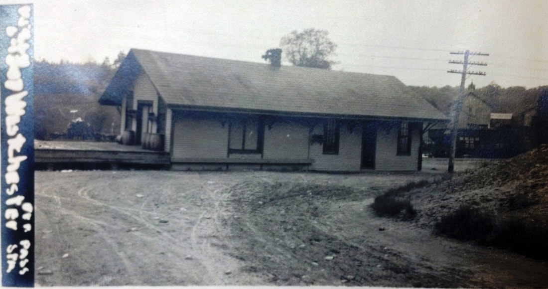
National Archives
|
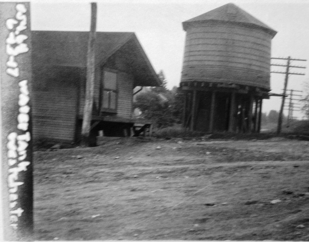
National Archives
|
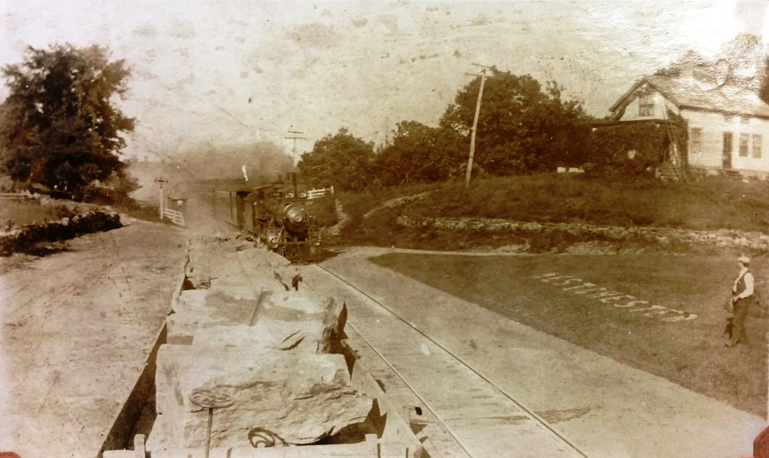
Ramsdell Transportation Collection
|
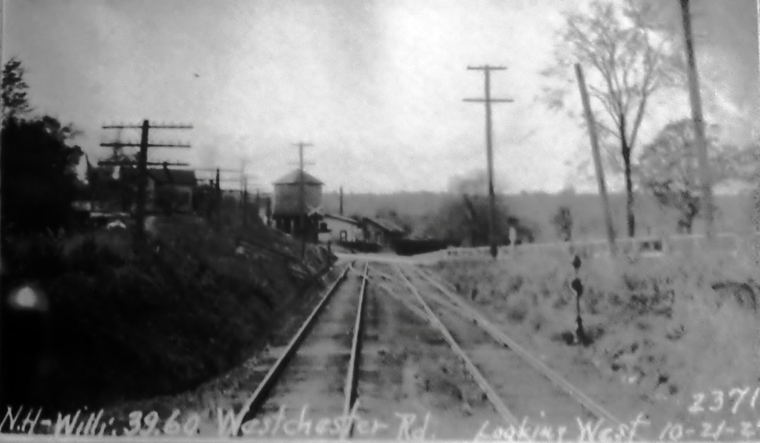
Max Miller Collection
|
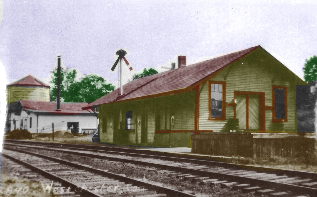
|

|
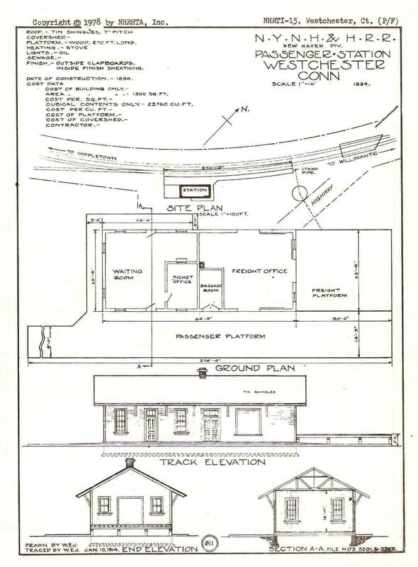 Copyright NHRHTA
WESTCHESTER2 [NYNH&H, 1895]
This depot likely opened early in 1895. The closest we can get, albeit speculative, is the NYNH&H annual report of 6/30/1895 which lists a specific expenditure of $20,838.13 for "West Chester Freight Station and Grounds." This amount represented a huge expenditure in light of the fact that the total for other passenger stations was $11,776.14 and other freight depots was $14,334.24. It is unclear why a relatively minor stop would merit improvements that would include the taking of more land, the building of a new station and the erection of a new water tank. Timetables of the era did, however, spell the stop as two words so the annual report likely meant this location. The anomaly here is that this structure appears to be a classic combination depot, with a freight section, door and platform on the west end. A check of the 1915 val map shows only this depot and not even the water tank, although we have seen the latter omitted elsewhere. The ICC photo at [1] looks to be dated 6/13/1917 and just cuts out the newer tank which stood at the highway east of the station. The separate ICC shot of the tank at [2] was taken the same day. The image at [3] shows the Air Line Limited at this location with the iconic double headlamps as it was about to pass rock-filled gondolas on the house track in the foreground. The date of this photo has to be between 1895 and 1902 when this train ran, replacing the famed New England Limited, popularly known as the White Train. Perhaps that is the stationmaster at right tending the manicured grounds; the WESTCHESTER on the lawn shows the pride locals once took in their rail facilities. The PUC's westward view at [4] was taken on 10/21/1927, the year verified in other photos. The eastward-looking shot at [5] is Lewis H. Benton's #2840 and we have used Al Weaver's colorized version to highlight the station, milk depot and water tank. Another copy we have is hand-dated 9/7/1931 by fellow photographer Irving Drake. The 1934 aerial map at [6] corresponds with Benton showing the three structures at our red arrows. The New Haven Dairy Co. operated the business which closed in 1934 when local farmers turned to other means to get their product to market, including trucks and holding tanks from which milk was transferred to railroad tank cars. The area was famed also for its wood products. Fred B. Clark, the "tie king of New England," gathered railroad ties for seasoning here whence they were largely supplied to the NYNH&H. A note on the 1938 SSRR inventory says the tank was later removed on 9/8/1939, sold to a local for $5.00! It does not list this station, implying to us that it was already gone, but the 1965 aerial seems to still show it, by then in use for freight only. Regular passenger service on the Air Line ended ca. 1927, according to Karr. This station may have been relocated slightly as part of the realignment of the Air Line in 1911. That project stretched from Portland to Columbia and involved the elimination of 23 grade crossings and the re-channeling of Ten Mile River and of Dickinson Creek under the Lyman Viaduct. The railroad commissioners reviewed 75 blueprint maps filed with them and gave their permission on 7/7/1911, with the NYNH&H to pay all the expenses. This was in contrast to the usual sharing of costs with municipalities, either by law or because of the town's initiation of the changes to be made. The NHRHTA data sheet at [7] shows the 1894 plan for the second station in a tracing by the real estate department on 1/10/1914. [REFS: NHAR24.1895.13; NHJC/10/04/1895/03; NHJC/07/10/1896/07: robbery; CRC59.1911.15; HC/01/16/1934/02; HC/12/07/1947/SM4; HC/02/26/1953/6D: flashing signals end stop-and-flag; RRC12.246; K90][rev100417, 122921, 020523]
This depot likely opened early in 1895. The closest we can get, albeit speculative, is the NYNH&H annual report of 6/30/1895 which lists a specific expenditure of $20,838.13 for "West Chester Freight Station and Grounds." This amount represented a huge expenditure in light of the fact that the total for other passenger stations was $11,776.14 and other freight depots was $14,334.24. It is unclear why a relatively minor stop would merit improvements that would include the taking of more land, the building of a new station and the erection of a new water tank. Timetables of the era did, however, spell the stop as two words so the annual report likely meant this location. The anomaly here is that this structure appears to be a classic combination depot, with a freight section, door and platform on the west end. A check of the 1915 val map shows only this depot and not even the water tank, although we have seen the latter omitted elsewhere. The ICC photo at [1] looks to be dated 6/13/1917 and just cuts out the newer tank which stood at the highway east of the station. The separate ICC shot of the tank at [2] was taken the same day. The image at [3] shows the Air Line Limited at this location with the iconic double headlamps as it was about to pass rock-filled gondolas on the house track in the foreground. The date of this photo has to be between 1895 and 1902 when this train ran, replacing the famed New England Limited, popularly known as the White Train. Perhaps that is the stationmaster at right tending the manicured grounds; the WESTCHESTER on the lawn shows the pride locals once took in their rail facilities. The PUC's westward view at [4] was taken on 10/21/1927, the year verified in other photos. The eastward-looking shot at [5] is Lewis H. Benton's #2840 and we have used Al Weaver's colorized version to highlight the station, milk depot and water tank. Another copy we have is hand-dated 9/7/1931 by fellow photographer Irving Drake. The 1934 aerial map at [6] corresponds with Benton showing the three structures at our red arrows. The New Haven Dairy Co. operated the business which closed in 1934 when local farmers turned to other means to get their product to market, including trucks and holding tanks from which milk was transferred to railroad tank cars. The area was famed also for its wood products. Fred B. Clark, the "tie king of New England," gathered railroad ties for seasoning here whence they were largely supplied to the NYNH&H. A note on the 1938 SSRR inventory says the tank was later removed on 9/8/1939, sold to a local for $5.00! It does not list this station, implying to us that it was already gone, but the 1965 aerial seems to still show it, by then in use for freight only. Regular passenger service on the Air Line ended ca. 1927, according to Karr. This station may have been relocated slightly as part of the realignment of the Air Line in 1911. That project stretched from Portland to Columbia and involved the elimination of 23 grade crossings and the re-channeling of Ten Mile River and of Dickinson Creek under the Lyman Viaduct. The railroad commissioners reviewed 75 blueprint maps filed with them and gave their permission on 7/7/1911, with the NYNH&H to pay all the expenses. This was in contrast to the usual sharing of costs with municipalities, either by law or because of the town's initiation of the changes to be made. The NHRHTA data sheet at [7] shows the 1894 plan for the second station in a tracing by the real estate department on 1/10/1914. [REFS: NHAR24.1895.13; NHJC/10/04/1895/03; NHJC/07/10/1896/07: robbery; CRC59.1911.15; HC/01/16/1934/02; HC/12/07/1947/SM4; HC/02/26/1953/6D: flashing signals end stop-and-flag; RRC12.246; K90][rev100417, 122921, 020523]

WESTFIELD1 [M&B, 1850]
This stop in the township of MIDDLETOWN was probably established when the Middletown RR opened in 1850, perhaps just as a flag stop since only BERLIN and EAST BERLIN are seen on a 2/20/1867 timetable. The first actual reference to a station here comes in 1859 when "black hearted villainy" caused someone to try derailing a train that had "just passed the Westfield station" heading for Middletown by leaving a large log on the track. The actual location of the 'Westfield society' was somewhat to the south on today's Rte. 217, centered around the Congregational Church. The station was just below the Middletown's border with Cromwell that is formed by the stream known variously as the Sebethe, the Little, or the Mattabesett River, as shown on the 1874 map. We have no picture yet of the first structure that was replaced by "a new station house" in 1875. [REFS: MC/08/10/1859/02; MC/12/08/1875/02; DC/12/27/1875/02]
This stop in the township of MIDDLETOWN was probably established when the Middletown RR opened in 1850, perhaps just as a flag stop since only BERLIN and EAST BERLIN are seen on a 2/20/1867 timetable. The first actual reference to a station here comes in 1859 when "black hearted villainy" caused someone to try derailing a train that had "just passed the Westfield station" heading for Middletown by leaving a large log on the track. The actual location of the 'Westfield society' was somewhat to the south on today's Rte. 217, centered around the Congregational Church. The station was just below the Middletown's border with Cromwell that is formed by the stream known variously as the Sebethe, the Little, or the Mattabesett River, as shown on the 1874 map. We have no picture yet of the first structure that was replaced by "a new station house" in 1875. [REFS: MC/08/10/1859/02; MC/12/08/1875/02; DC/12/27/1875/02]
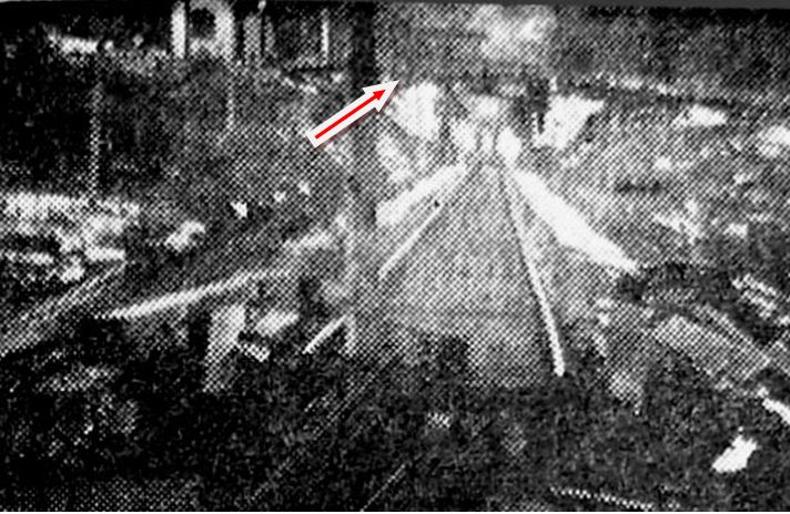
|
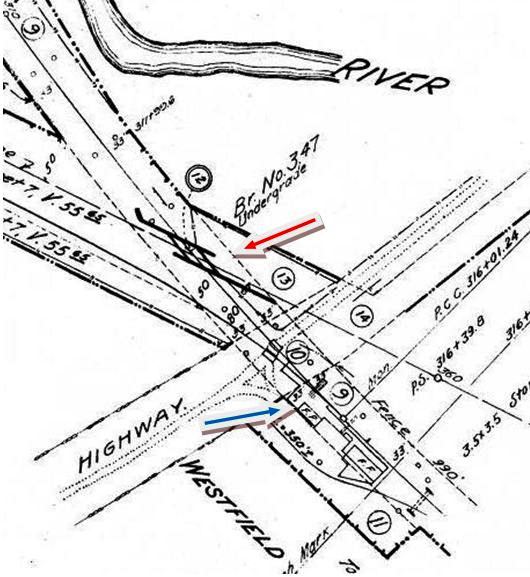
|
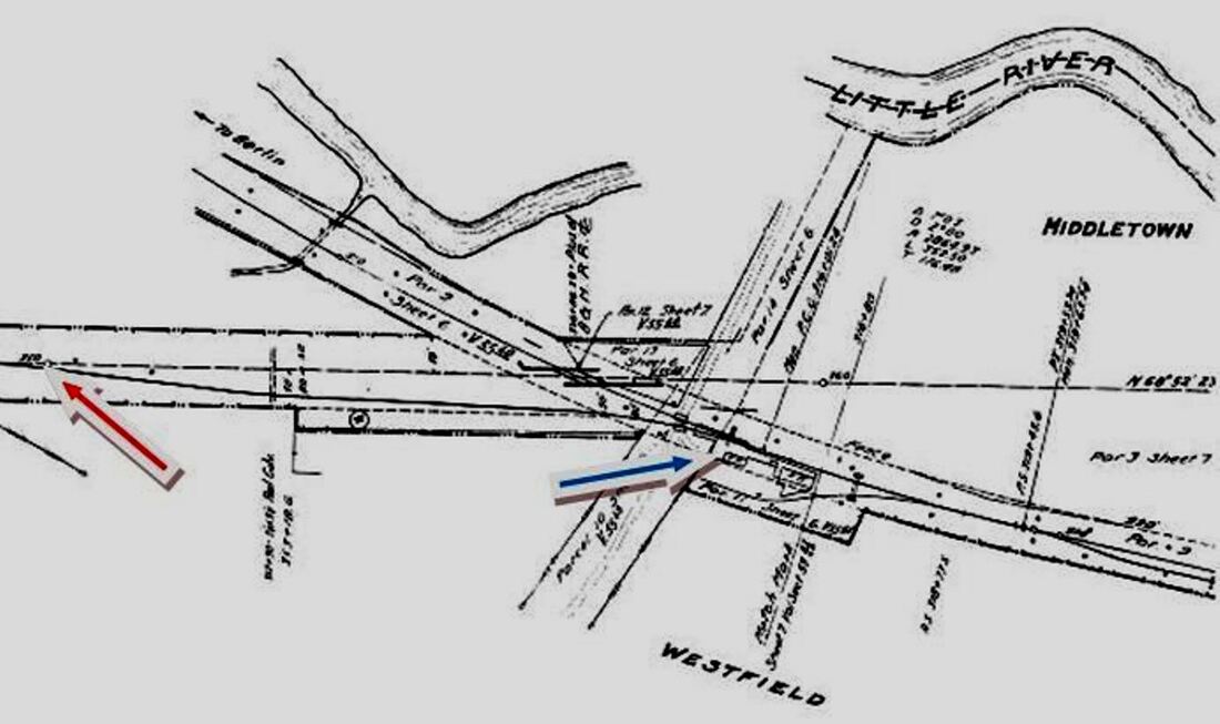
|
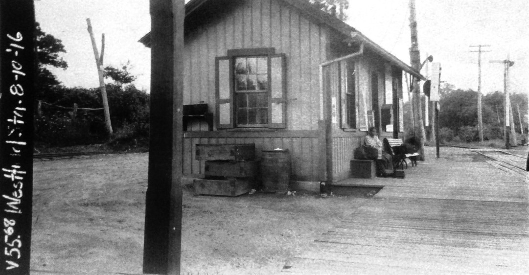
|
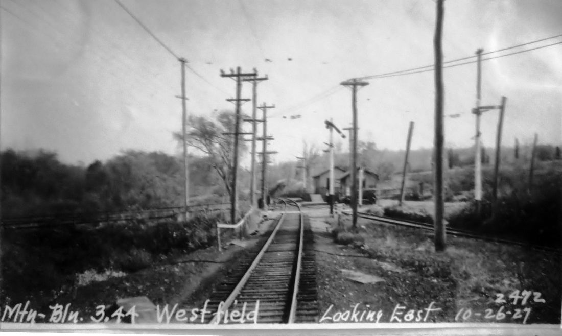
|
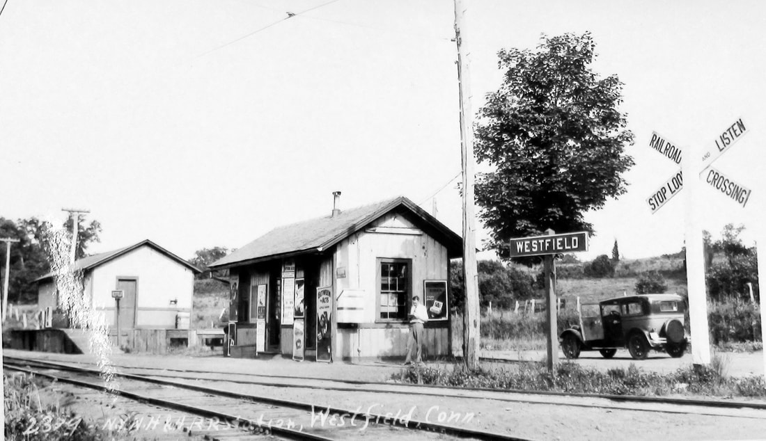
|
WESTFIELD2 [NYNH&H, 1875]
The second station was built here in 1875, at which time the newspaper remarked about how the Consolidated road was caring for the Middletown branch line, with well-maintained track and rail bed, courteous station agents at BERLIN and MIDDLETOWN, a newly appointed one here where apparently none had been before, and the engine Connecticut heading the trains. The new station, according to one article, was "a neat and tasty building, with a warm and comfortable waiting room." By 1876, a Little River post office was established at the depot and Station Agent J.W. Nichols, as often was the custom of the day, was likely the postmaster as well. Things settled down until discontent with the NYNH&H shipping rates to Meriden led to a call for a new railroad from the Silver City to the Connecticut River, with the primary intent of obtaining coal at cheaper prices. Westfield would, thus, become an intersection point with the Meriden & Cromwell RR in 1885 and the crossroads of even more traffic when the M&C was extended to Waterbury in 1888 and rechristened as the Meriden, Waterbury and Connecticut River RR. The Consolidated was antagonistic to this project and objected to any grade crossings or connections with its affiliated lines. Here, this meant the M&C had to build an underpass at the Berlin branch. Perhaps captured in no other photo, the bridge is seen in the distance in the shot at [1] taken from the Little River crossing where a collapsed bridge threw an MW&CR train into the water in January, 1891. Also seen on the embankment to the left of the bridge is a building that seems to correspond with the photos we have of WESTFIELD2. Reorganized as the Middletown, Meriden and Waterbury RR in 1898, the line would be obtained through surrogates by the NYNH&H which discontinued the portion from Westfield to Cromwell and brought trains to Middletown instead. Service commenced on 1/2/1899 after a link to the Berlin branch was installed. On the 1915 val map at [2], the red arrow points to the undergrade bridge that apparently still stood at the time; the track to Cromwell, removed in 1903, is shown as a dashed line. The red arrow on the val map at [3] indicates where the connection was made between the two branches. The blue arrow on both maps points to WESTFIELD2, which probably served both independent lines and was described in 1909 as "a small brown station," a rare detail of interest for the avid modelers out there. The 8/10/1916 ICC valuation at [4] looks west. The PUC photo at [5] looks east. The dark area north of the tracks is the location of the undergrade bridge, no longer seen and removed sometime between 1915 and the 10/26/1927 date of the photo. The Lewis H. Benton shot #2379 at [6] dates to 6/22/1929; fellow photographer Irving Drake is playing nonchalant and his sedan with door opened likely intends to portray the 'rush' to get here, a usual gimmick of the duo. Both photos show the the Meriden line now coming in at the grade crossing. With third-rail power outlawed in 1906 because of electrocution hazards, this electric service from from Meriden to Middletown was initiated on 7/8/1907 under wire, the same time it debuted on the Berlin line. The headline in the Courant said "Say Goodbye to the Dinky," the small, smoky former New York Elevated steam locos used previously, upon the inauguration of the service when there would be 29 electric trains to Berlin and 38 to Meriden from Middletown six days per week and a few less on Sundays. With freight trains restricted to night operation, Connecticut Co. trolleys, guided by NYNH&H 'pilot' personnel, used the track to Middletown during the day, in later days apparently sharing it with NYNH&H steam passenger trains. In spite of precautions, there was one fatal accident on 10/10/1913 between a trolley and a steam train at Westfield. Our research has clarified that a 1984 Shoreliner article speculates correctly about a postcard view of this crash in which a Meriden-bound trolley that failed to wait at NEWFIELD crashed into a tender-first steam train headed for Middletown. Electric service on the Berlin branch was discontinued in 1927 in favor of an increased steam train schedule, with trolleys still running from Westfield to Meriden. The latter were cut in 1932 and physical abandonment of the track from Westfield to York Hill Quarry came at the end of 1937, bus service used thereafter on U.S. Rte. 6A, today's Rte. 66. Westfield, while it never became a big main line station, achieved a certain distinction for its uniqueness as a junction without intersecting tracks, the later connection of the two branches, the multiplicity of the types of service and equipment hosted, and the 70 or so daily traffic movements it saw in the early years of the last century. [REFS: MC/12/08/1875/02; DC/12/27/1875/02; NHER/01/03/1884/01; CRC31.1884.9; HC/01/13/1891/06; NHER/10/01/1892/01: Westfield, Mass.?; DN/06/11/1897/08; HC/11/25/1898/00; HC/12/26/1906/13; HC/07/05/1907/05; HC/07/08/1907/16; HC/05/08/1909/16: small brown building; HC/01/06/1913/12; HC/10/12/1913/05; HC/11/06/1913/12; HC/11/11/1916/05; HC/11/20/1927/C9; ICC Finance Dkt 11653; PUC Dkt 6519; SL15.1.6][rev012915, 021320, 011123]
The second station was built here in 1875, at which time the newspaper remarked about how the Consolidated road was caring for the Middletown branch line, with well-maintained track and rail bed, courteous station agents at BERLIN and MIDDLETOWN, a newly appointed one here where apparently none had been before, and the engine Connecticut heading the trains. The new station, according to one article, was "a neat and tasty building, with a warm and comfortable waiting room." By 1876, a Little River post office was established at the depot and Station Agent J.W. Nichols, as often was the custom of the day, was likely the postmaster as well. Things settled down until discontent with the NYNH&H shipping rates to Meriden led to a call for a new railroad from the Silver City to the Connecticut River, with the primary intent of obtaining coal at cheaper prices. Westfield would, thus, become an intersection point with the Meriden & Cromwell RR in 1885 and the crossroads of even more traffic when the M&C was extended to Waterbury in 1888 and rechristened as the Meriden, Waterbury and Connecticut River RR. The Consolidated was antagonistic to this project and objected to any grade crossings or connections with its affiliated lines. Here, this meant the M&C had to build an underpass at the Berlin branch. Perhaps captured in no other photo, the bridge is seen in the distance in the shot at [1] taken from the Little River crossing where a collapsed bridge threw an MW&CR train into the water in January, 1891. Also seen on the embankment to the left of the bridge is a building that seems to correspond with the photos we have of WESTFIELD2. Reorganized as the Middletown, Meriden and Waterbury RR in 1898, the line would be obtained through surrogates by the NYNH&H which discontinued the portion from Westfield to Cromwell and brought trains to Middletown instead. Service commenced on 1/2/1899 after a link to the Berlin branch was installed. On the 1915 val map at [2], the red arrow points to the undergrade bridge that apparently still stood at the time; the track to Cromwell, removed in 1903, is shown as a dashed line. The red arrow on the val map at [3] indicates where the connection was made between the two branches. The blue arrow on both maps points to WESTFIELD2, which probably served both independent lines and was described in 1909 as "a small brown station," a rare detail of interest for the avid modelers out there. The 8/10/1916 ICC valuation at [4] looks west. The PUC photo at [5] looks east. The dark area north of the tracks is the location of the undergrade bridge, no longer seen and removed sometime between 1915 and the 10/26/1927 date of the photo. The Lewis H. Benton shot #2379 at [6] dates to 6/22/1929; fellow photographer Irving Drake is playing nonchalant and his sedan with door opened likely intends to portray the 'rush' to get here, a usual gimmick of the duo. Both photos show the the Meriden line now coming in at the grade crossing. With third-rail power outlawed in 1906 because of electrocution hazards, this electric service from from Meriden to Middletown was initiated on 7/8/1907 under wire, the same time it debuted on the Berlin line. The headline in the Courant said "Say Goodbye to the Dinky," the small, smoky former New York Elevated steam locos used previously, upon the inauguration of the service when there would be 29 electric trains to Berlin and 38 to Meriden from Middletown six days per week and a few less on Sundays. With freight trains restricted to night operation, Connecticut Co. trolleys, guided by NYNH&H 'pilot' personnel, used the track to Middletown during the day, in later days apparently sharing it with NYNH&H steam passenger trains. In spite of precautions, there was one fatal accident on 10/10/1913 between a trolley and a steam train at Westfield. Our research has clarified that a 1984 Shoreliner article speculates correctly about a postcard view of this crash in which a Meriden-bound trolley that failed to wait at NEWFIELD crashed into a tender-first steam train headed for Middletown. Electric service on the Berlin branch was discontinued in 1927 in favor of an increased steam train schedule, with trolleys still running from Westfield to Meriden. The latter were cut in 1932 and physical abandonment of the track from Westfield to York Hill Quarry came at the end of 1937, bus service used thereafter on U.S. Rte. 6A, today's Rte. 66. Westfield, while it never became a big main line station, achieved a certain distinction for its uniqueness as a junction without intersecting tracks, the later connection of the two branches, the multiplicity of the types of service and equipment hosted, and the 70 or so daily traffic movements it saw in the early years of the last century. [REFS: MC/12/08/1875/02; DC/12/27/1875/02; NHER/01/03/1884/01; CRC31.1884.9; HC/01/13/1891/06; NHER/10/01/1892/01: Westfield, Mass.?; DN/06/11/1897/08; HC/11/25/1898/00; HC/12/26/1906/13; HC/07/05/1907/05; HC/07/08/1907/16; HC/05/08/1909/16: small brown building; HC/01/06/1913/12; HC/10/12/1913/05; HC/11/06/1913/12; HC/11/11/1916/05; HC/11/20/1927/C9; ICC Finance Dkt 11653; PUC Dkt 6519; SL15.1.6][rev012915, 021320, 011123]
WESTOVER [> HOSKINS]

WESTPORT1 [NY&NH, 1848]
The 1868 map of the Saugatuck area of town shows the railroad station on the east side of the river, not the west side as at present, the change probably having been made with the four-tracking of 1893. We have no photo yet of this station, which if it followed the pattern of most all the other early NY&NY depots, was the cross-gabled Gothic type, like STRATFORD1, NORWALK1 and others.
The 1868 map of the Saugatuck area of town shows the railroad station on the east side of the river, not the west side as at present, the change probably having been made with the four-tracking of 1893. We have no photo yet of this station, which if it followed the pattern of most all the other early NY&NY depots, was the cross-gabled Gothic type, like STRATFORD1, NORWALK1 and others.
WESTPORT2 [NYNY&H, 1873]
A newly found Constitution article says that "the new depot building at Westport will be ready for use May 1st." We assume it was also east of the Saugatuck River. We have no photo yet. [REFS: MDC/03/12/1873/03]
A newly found Constitution article says that "the new depot building at Westport will be ready for use May 1st." We assume it was also east of the Saugatuck River. We have no photo yet. [REFS: MDC/03/12/1873/03]
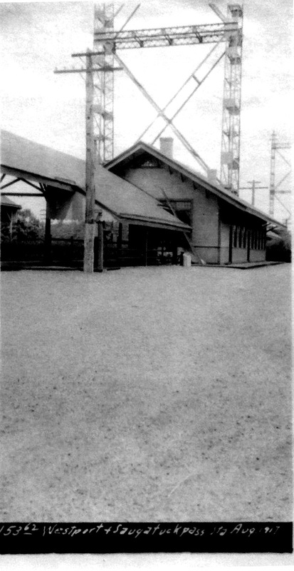
Dave Peters Collection
|

|
WESTPORT3 [NYNH&H, 1891, EB]
This stop was called WESTPORT AND SAUGATUCK in later days, perhaps to reflect the move to a location west of the river at this time.
This stop was called WESTPORT AND SAUGATUCK in later days, perhaps to reflect the move to a location west of the river at this time.

Archives & Spec Colls, UConn
|
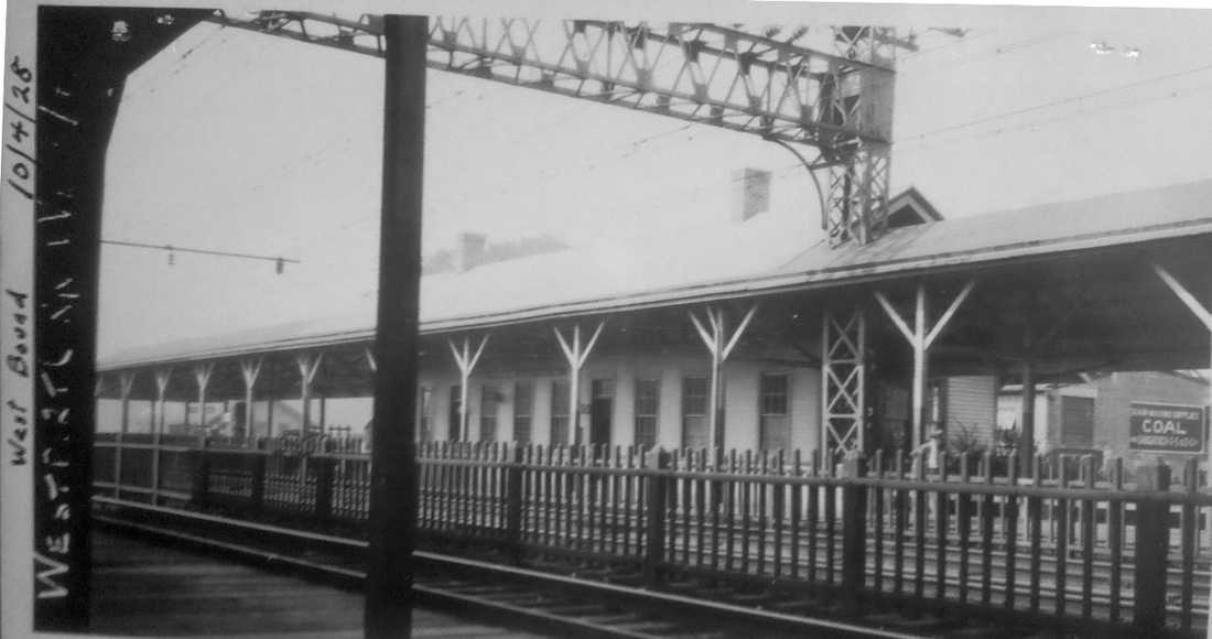
|
WESTPORT4 [NYNH&H, 1895?, WB]
This is the station on the westbound side was built as part of the 1890s four-tracking project. The image at left is dated 8/2/1955. [REFS: R107]
This is the station on the westbound side was built as part of the 1890s four-tracking project. The image at left is dated 8/2/1955. [REFS: R107]
WESTWAY [> WEST STREET]

|
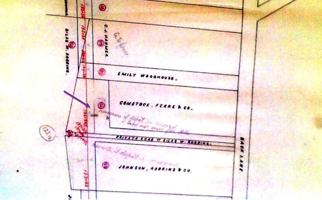
New Haven Museum
|
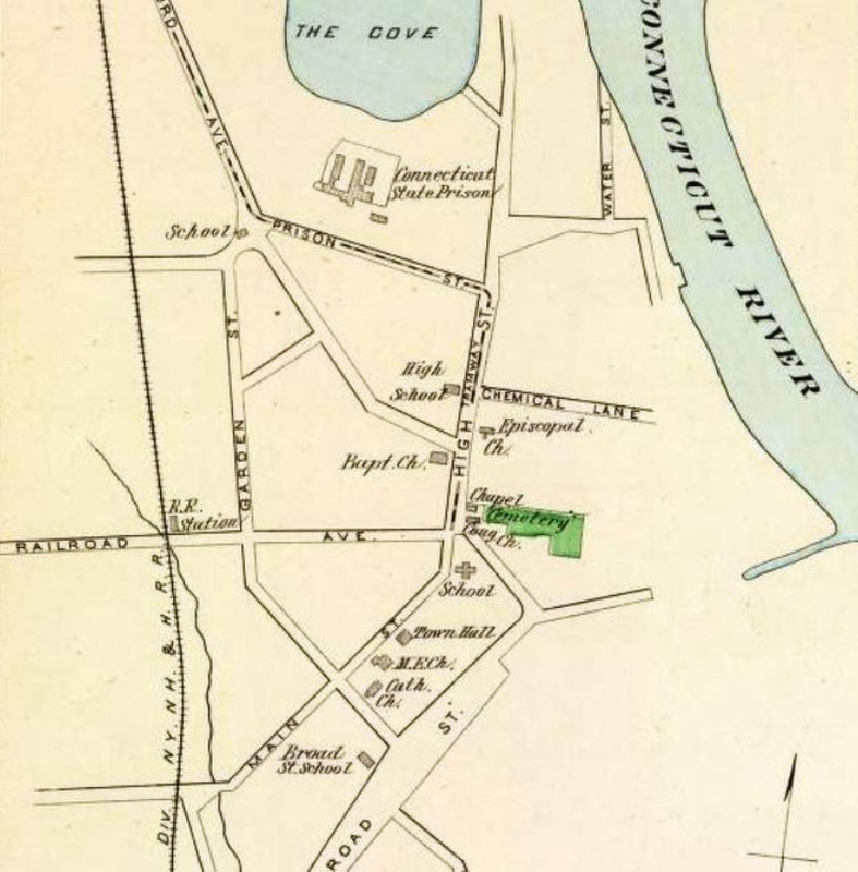
|
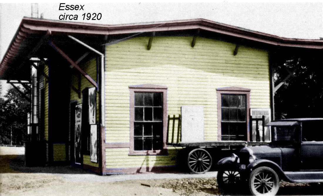
WETHERSFIELD1 [CV, 1871]
The CV opened on 8/24/1871 through this historic town, known far and wide for its red onions and from 1827 to 1963 as the site of the state prison. The Courant says that a long inaugural train started out from the temporary depot at Colt's in Hartford about 9:00 a.m. and "soon arrived at Wethersfield where a gathering of citizens and a drum corps saluted the excursionists. The new depot was decorated with flags, and there were general demonstrations of rejoicing." The 1869 map at [1] shows the proposed route a little easterly of where it would be built; our arrow shows where the depot would stand. The image at [2] is from the 1873 real estate atlas and shows the station penciled in above a private roadway that ran between Comstock, Ferre & Co. and Johnson, Robbins & Co., two of Wethersfield's legendary seed producers. The street is seen on the 1893 Hurd map at [3] as Railroad Ave. No photos of this station have yet been found but Max Miller, well-known CV historian, says it is thought to be the flat-W style of architecture like ESSEX1, which we have borrowed and placed at [4]. A Register article explains the fate of this first structure: "WETHERSFIELD DEPOT BURNED. It Is Thought Burglars Were at Work There Last Night... The Wethersfield station of the Hartford and Connecticut Valley Railroad, was burned... this morning. The fire company responded, but there was no water near and nothing could be done. It is believed that burglars were trying to blow open the safe and started the fire..." Other articles add more detail. The Courant tells us that the 4:00 a.m.-ish conflagration was discovered by Mrs. McBride and word was telephoned to the 'freight station,' apparently in Hartford, to send an engine down to move two cars on the siding in front of the station. A carload of coal for Bulkeley & Hammer was saved but the Springfield Republican tells us that a freight car of sole leather was lost. It had been consigned to Marcy Bros., contractors at the nearby state prison where inmates made boots as well as clothing and other saleable goods. The depot safe was said to lie in "the midst of the station ruins with a small hole in the door near the combination knob." Supt Davidson came from Hartford to supervise the clean-up and the tracks were cleared by about 8:00 a.m. with the 6:40 southbound train delayed about 40 minutes and the northbound, due in Hartford at 7:55, held up about 15 minutes. The station was reportedly valued at $5,000. [REFS: HDC/08/25/1871/02; NHER/04/28/1896/02; HC/04/29/1896/10; SR/04/ 29/1896/10; HC/05/13/1896/08; HC/06/15/1896/08][rev120814, ckd 011123]
The CV opened on 8/24/1871 through this historic town, known far and wide for its red onions and from 1827 to 1963 as the site of the state prison. The Courant says that a long inaugural train started out from the temporary depot at Colt's in Hartford about 9:00 a.m. and "soon arrived at Wethersfield where a gathering of citizens and a drum corps saluted the excursionists. The new depot was decorated with flags, and there were general demonstrations of rejoicing." The 1869 map at [1] shows the proposed route a little easterly of where it would be built; our arrow shows where the depot would stand. The image at [2] is from the 1873 real estate atlas and shows the station penciled in above a private roadway that ran between Comstock, Ferre & Co. and Johnson, Robbins & Co., two of Wethersfield's legendary seed producers. The street is seen on the 1893 Hurd map at [3] as Railroad Ave. No photos of this station have yet been found but Max Miller, well-known CV historian, says it is thought to be the flat-W style of architecture like ESSEX1, which we have borrowed and placed at [4]. A Register article explains the fate of this first structure: "WETHERSFIELD DEPOT BURNED. It Is Thought Burglars Were at Work There Last Night... The Wethersfield station of the Hartford and Connecticut Valley Railroad, was burned... this morning. The fire company responded, but there was no water near and nothing could be done. It is believed that burglars were trying to blow open the safe and started the fire..." Other articles add more detail. The Courant tells us that the 4:00 a.m.-ish conflagration was discovered by Mrs. McBride and word was telephoned to the 'freight station,' apparently in Hartford, to send an engine down to move two cars on the siding in front of the station. A carload of coal for Bulkeley & Hammer was saved but the Springfield Republican tells us that a freight car of sole leather was lost. It had been consigned to Marcy Bros., contractors at the nearby state prison where inmates made boots as well as clothing and other saleable goods. The depot safe was said to lie in "the midst of the station ruins with a small hole in the door near the combination knob." Supt Davidson came from Hartford to supervise the clean-up and the tracks were cleared by about 8:00 a.m. with the 6:40 southbound train delayed about 40 minutes and the northbound, due in Hartford at 7:55, held up about 15 minutes. The station was reportedly valued at $5,000. [REFS: HDC/08/25/1871/02; NHER/04/28/1896/02; HC/04/29/1896/10; SR/04/ 29/1896/10; HC/05/13/1896/08; HC/06/15/1896/08][rev120814, ckd 011123]
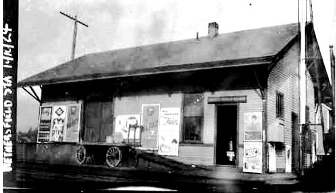
Robert Lingane Collection
|
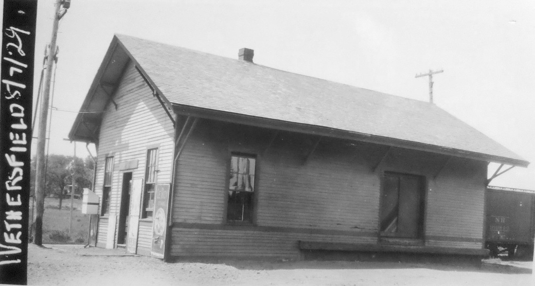
Dave Peters Collection
|
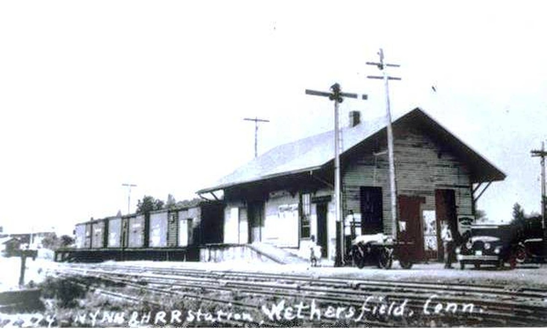
|

|

|
|
WETHERSFIELD2 [NYNH&H, 1896]
An 8/15/1896 article from the Courant informs us that "the depot which is being erected in place of the one which was burned some time ago, is nearing completion and will be occupied soon." This structure still stands today on what is now Church St. The ICC valuation photo at [1] is from 1924 and the next at [2] is a PUC shot dated 8/7/1929. The image at [3] is a Lewis H. Benton from the 1930s, with fellow photographer Irving N. Drake standing by his sedan that carried the duo on their photographic odysseys. Station Agent William J. Cronan would recount in 1943 on the eve of his retirement that as many as 12 daily passenger trains once stopped here on their way to and from Saybrook and New London. He also noted that the two remaining Wethersfield seed companies still did a heavy freight and express business and that Gra-Rock had taken over the old Elmore Tool Mfg. Co. complex, seen southwest of the station on the 6/30/1915 ICC valuation map at [4]. The beverage company, best known perhaps for its original Canton location, purchased property here in 1928. The image at [5] shows a three-car consist carrying the PUC commissioners around for one of their annual inspections in the 1950s, rather lavishly it would appear. WETHERSFIELD2 remained in railroad service reportedly into the mid-1950s, perhaps coinciding with the retirement of Agent Wallace H. Peck in 1957. In 1972, two Wethersfield women, Teresa Larue and Elaine Toscano, purchased the building from Penn Central. Their "country store," The Railroad Place, opened on 11/9/1972, a date that coincided with a derailment nearby. In a perhaps unique level of service by employees of the oft-maligned Penn Central the 1972 Courant photo at [6] shows two PC locomotives, the lead engine abreast of the station and its wheels being used to chop wood for the ladies! In this rather whimsical story, the captioning says that the crew had found some rotted timbers which they were turning into firewood for the pot-belly stove, the only heat source in the old depot. The image at [7] was taken by us on 2/25/2012. [REFS: HC/08/15/1896/10; HC/06/24/1928/B7; HC/09/24/1938/22; HC/07/15/1943/15; HC/07/08/1957/17; HC/08/22/1972/24; HC/11/10/1972/1A][rev120814, 112818, 011123]
An 8/15/1896 article from the Courant informs us that "the depot which is being erected in place of the one which was burned some time ago, is nearing completion and will be occupied soon." This structure still stands today on what is now Church St. The ICC valuation photo at [1] is from 1924 and the next at [2] is a PUC shot dated 8/7/1929. The image at [3] is a Lewis H. Benton from the 1930s, with fellow photographer Irving N. Drake standing by his sedan that carried the duo on their photographic odysseys. Station Agent William J. Cronan would recount in 1943 on the eve of his retirement that as many as 12 daily passenger trains once stopped here on their way to and from Saybrook and New London. He also noted that the two remaining Wethersfield seed companies still did a heavy freight and express business and that Gra-Rock had taken over the old Elmore Tool Mfg. Co. complex, seen southwest of the station on the 6/30/1915 ICC valuation map at [4]. The beverage company, best known perhaps for its original Canton location, purchased property here in 1928. The image at [5] shows a three-car consist carrying the PUC commissioners around for one of their annual inspections in the 1950s, rather lavishly it would appear. WETHERSFIELD2 remained in railroad service reportedly into the mid-1950s, perhaps coinciding with the retirement of Agent Wallace H. Peck in 1957. In 1972, two Wethersfield women, Teresa Larue and Elaine Toscano, purchased the building from Penn Central. Their "country store," The Railroad Place, opened on 11/9/1972, a date that coincided with a derailment nearby. In a perhaps unique level of service by employees of the oft-maligned Penn Central the 1972 Courant photo at [6] shows two PC locomotives, the lead engine abreast of the station and its wheels being used to chop wood for the ladies! In this rather whimsical story, the captioning says that the crew had found some rotted timbers which they were turning into firewood for the pot-belly stove, the only heat source in the old depot. The image at [7] was taken by us on 2/25/2012. [REFS: HC/08/15/1896/10; HC/06/24/1928/B7; HC/09/24/1938/22; HC/07/15/1943/15; HC/07/08/1957/17; HC/08/22/1972/24; HC/11/10/1972/1A][rev120814, 112818, 011123]