Track 12: CT Passenger Stations, M-ME
See TCS Home Page links for notes, abbreviations, and sources.
Use Track 11 map link to locate stations, rail and trolley lines, and POIs.
Use Track 11 map link to locate stations, rail and trolley lines, and POIs.
|

Madison Historical Society
|

|
National Archives
|
Madison Historical Society
|

|
MADISON1 [NH&NL, 1852]
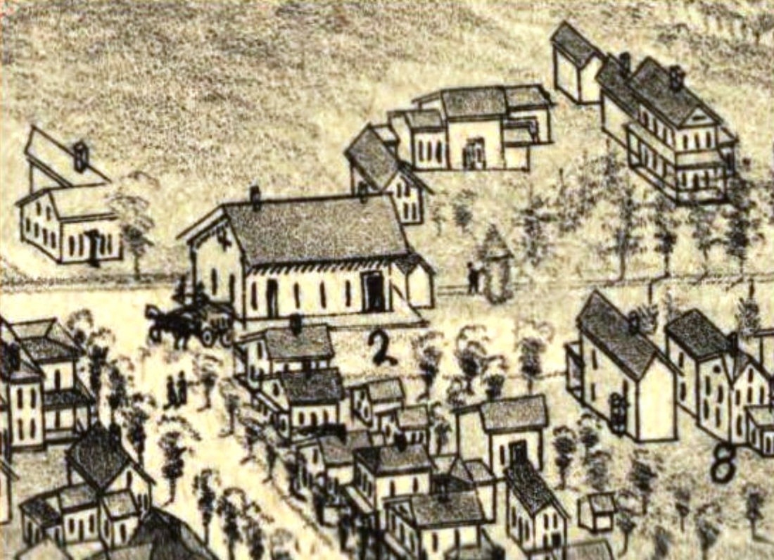
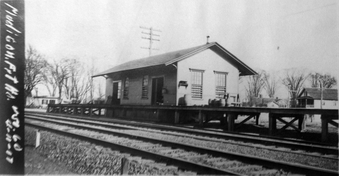
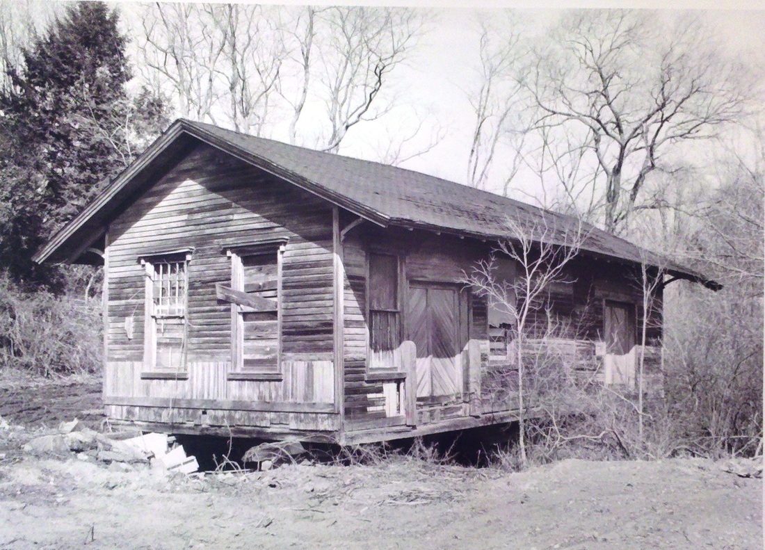
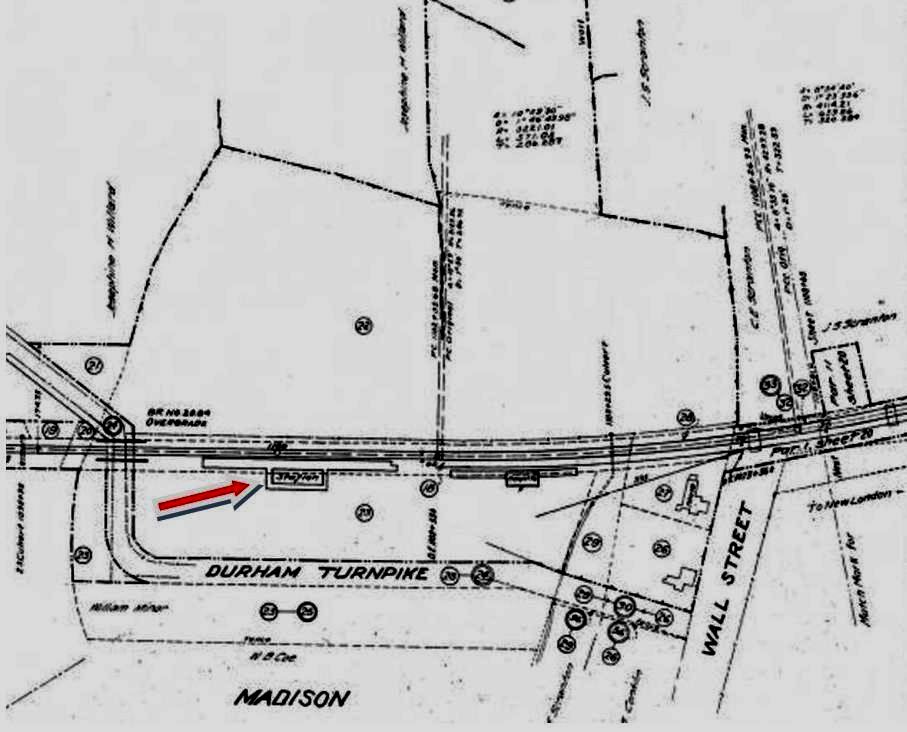
This stop was established when the NH&NL opened on 7/1/1852 and the first depot was likely built in that year. The image at [1] is from the 1881 Bailey bird's-eye map [click here]. The depot pedigree is authenticated by the compass ornament that the NYP&B affixed to the stations when it was lessee of this line from 1858 to 1862. This decoration has been noted in photographs or on the Bailey maps for all the early NH&NL depots, e.g. NOANK, WEST MYSTIC, several of which are extant and still sport this detail today. The view at [2] shows a New London-bound train ca. 1890; note the circular switch shanty in the foreground. The location of this first station was at the intersection of Wall St. and Railroad Ave., as seen on the 1868 Beers map at [3]. MADISON1 was moved slightly west to become the freight house when MADISON2 was built in 1896. The val photo at [4] is dated 4/11/1917. Info on the back of the shot at [5] says this is 1985 when the freight station "was moved to the swamp behind 56 Wall Street and afterward demolished." This happened in spite of a Railroad Depot Committee that was formed to dismantle, relocate and restore the venerable structure in 1986. It was, nevertheless, the model for the Senior Meeting Center or 'The Depot' which is at 9 Old Rte. 79. The snippet at [6] is from our Track 11 Google Earth map and shows the locations of all the stations over time. [REFS: SLT/05/01/1986/00; R63][rev032215]
This stop was established when the NH&NL opened on 7/1/1852 and the first depot was likely built in that year. The image at [1] is from the 1881 Bailey bird's-eye map [click here]. The depot pedigree is authenticated by the compass ornament that the NYP&B affixed to the stations when it was lessee of this line from 1858 to 1862. This decoration has been noted in photographs or on the Bailey maps for all the early NH&NL depots, e.g. NOANK, WEST MYSTIC, several of which are extant and still sport this detail today. The view at [2] shows a New London-bound train ca. 1890; note the circular switch shanty in the foreground. The location of this first station was at the intersection of Wall St. and Railroad Ave., as seen on the 1868 Beers map at [3]. MADISON1 was moved slightly west to become the freight house when MADISON2 was built in 1896. The val photo at [4] is dated 4/11/1917. Info on the back of the shot at [5] says this is 1985 when the freight station "was moved to the swamp behind 56 Wall Street and afterward demolished." This happened in spite of a Railroad Depot Committee that was formed to dismantle, relocate and restore the venerable structure in 1986. It was, nevertheless, the model for the Senior Meeting Center or 'The Depot' which is at 9 Old Rte. 79. The snippet at [6] is from our Track 11 Google Earth map and shows the locations of all the stations over time. [REFS: SLT/05/01/1986/00; R63][rev032215]
Dave Peters Collection
|

|
|

MADISON2 [NYNH&H, 1896]
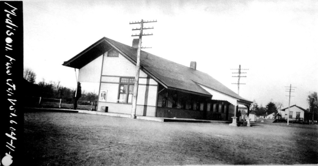
This saltbox-style station opened in 1896 west of the old location and MADISON1 was moved to sit adjacent as the freight house on the new depot grounds, as seen on the 1915 val map at [3]. The Journal Courier said on 9///1896: "Madison's New Depot. The new passenger depot of the Consolidated Road at Madison is completed and is much appreciated by patrons of the road. It is sixty feet long and very much like the Stony Creek station. The old depot is being utilized as a freight depot." The val photo at [1] is dated 4/11/1917 and shows this depot, unlike most of the NYNH&H stations of the period, sporting a fancy porte cochere. The view looks east, as does the image at [4]. The shot at [2] looks west. A 1969 Courant article says that "... the attractively remodeled old Madison Railroad Station..." had been fitted up a showroom for model homes as of 6/6/1969 by the George C. Field Co.,"a progressive and reliable company that was founded in 1897" and which was now specializing in low-cost homes. The Field company would go on to renovate NEW LONDON/U3, the 1887 Union Station, and MYSTIC3, the latter free of charge. [REFS: NHJC/09/11/1896/08; CRC44.1896.15; HC/06/08/1969/04E; HC/01/26/1977/37D][rev032215, 111118, 120318]
MADISON3 [NYNH&H, 1950s]
The 1969 NH-PC real estate transfer album has this photo of a waiting shed on westbound side, with a fence separating the tracks. To our knowledge these dual facilities only existed west of New Haven on the four-tracked main line. The same album has a photo of MADISON2 and says obliquely that "... Railroad reserves the space Ticket Office and Waiting Room, etc..." It attributes ownership to PC but also states that the one-story brick building is owned by the George C. Field Co. Beyond the fact that MADISON2 is obviously a wooden structure, we wonder if the westbound shelter was where passengers waited for trains in both directions while the company used the entire building for his business, the railroad reserving its rights for future. This arrangement is plausible but one we have never seen before. It was probably taken down by PC with other Shore Line shelters in 1973. [REFS: HC/06/08/1969/04E; HC/03/27/1973/13: PC to raze shelters and abandon service][rev111118]
The 1969 NH-PC real estate transfer album has this photo of a waiting shed on westbound side, with a fence separating the tracks. To our knowledge these dual facilities only existed west of New Haven on the four-tracked main line. The same album has a photo of MADISON2 and says obliquely that "... Railroad reserves the space Ticket Office and Waiting Room, etc..." It attributes ownership to PC but also states that the one-story brick building is owned by the George C. Field Co. Beyond the fact that MADISON2 is obviously a wooden structure, we wonder if the westbound shelter was where passengers waited for trains in both directions while the company used the entire building for his business, the railroad reserving its rights for future. This arrangement is plausible but one we have never seen before. It was probably taken down by PC with other Shore Line shelters in 1973. [REFS: HC/06/08/1969/04E; HC/03/27/1973/13: PC to raze shelters and abandon service][rev111118]
Lee Carlson photo
MADISON4 [SLE, 1990]
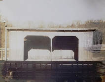
With the inauguration of Shore Line East service in May, 1990, this shelter and ones like it were put up along the route. This one stood until July, 2008 when MADISON5 was built.
With the inauguration of Shore Line East service in May, 1990, this shelter and ones like it were put up along the route. This one stood until July, 2008 when MADISON5 was built.
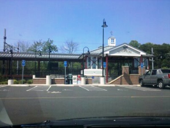
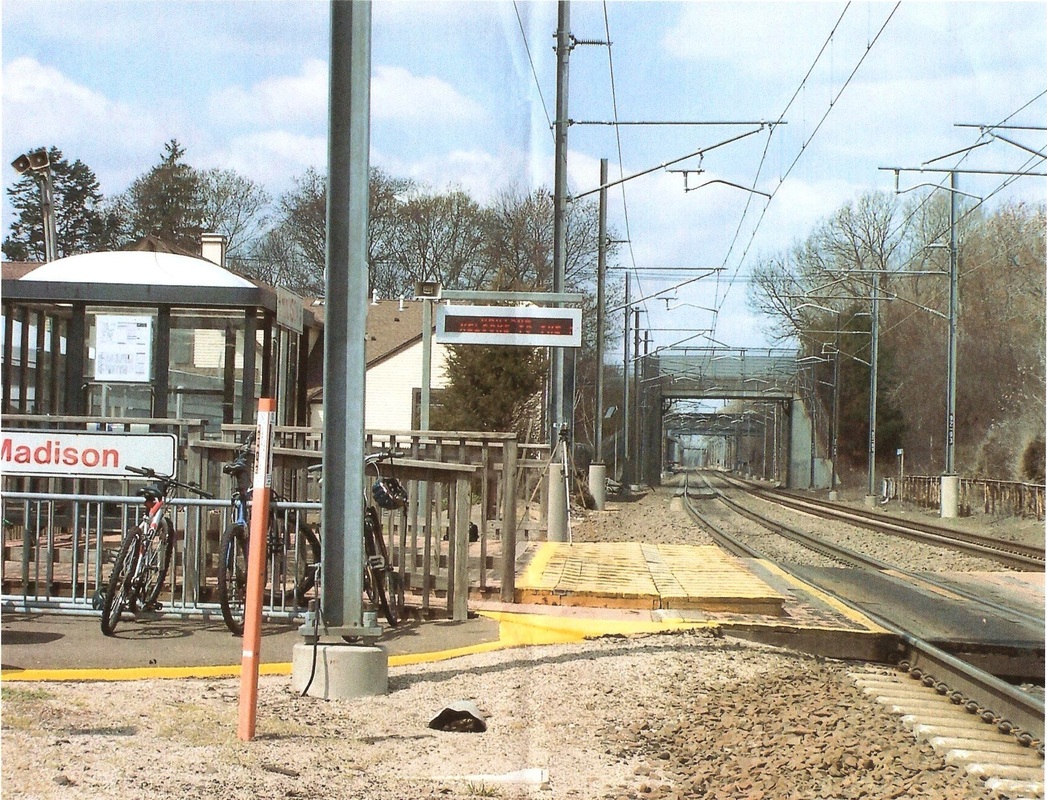
MADISON5 [SLE, 2008]
Shore Line East station, as seen on 8/2/2010.
Shore Line East station, as seen on 8/2/2010.
MAMACOKE [> HARRISON]

|
|
Connecticut Historical Society
|
MANCHESTER1 [HP&F, 1849; opened as UNION VILLAGE]
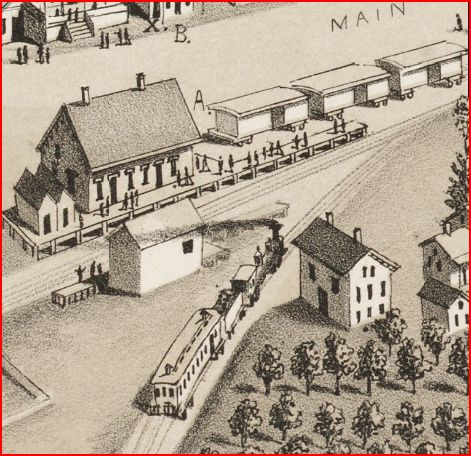
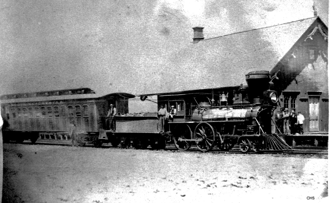
The first name for this stop when the HP&F opened in 1849 was UNION VILLAGE, as is seen on this 1855HC map at left but an 1851TT, however, already lists it as MANCHESTER. The station structure is seen on the Bailey 1880 bird's-eye map at middle. The train that is approaching is on the South Manchester RR and has just come up from the Cheney factories, which the tiny railroad connected to, by then the NY&NE main line. The timing of this sketch was fortuitous for, had the Bailey artist arrived in 1881 after MANCHESTER2 was built, we would not have this image of the first station. Click here for the LOC map collection. The photo at right was a lucky find at CHS. Although the sketch image shows two chimneys at the time it was done, it otherwise seems to match the photograph, right down to the trim design on the bargeboards.
The first name for this stop when the HP&F opened in 1849 was UNION VILLAGE, as is seen on this 1855HC map at left but an 1851TT, however, already lists it as MANCHESTER. The station structure is seen on the Bailey 1880 bird's-eye map at middle. The train that is approaching is on the South Manchester RR and has just come up from the Cheney factories, which the tiny railroad connected to, by then the NY&NE main line. The timing of this sketch was fortuitous for, had the Bailey artist arrived in 1881 after MANCHESTER2 was built, we would not have this image of the first station. Click here for the LOC map collection. The photo at right was a lucky find at CHS. Although the sketch image shows two chimneys at the time it was done, it otherwise seems to match the photograph, right down to the trim design on the bargeboards.

|
Archives & Spec Colls, UConn
|

|

|
|

|
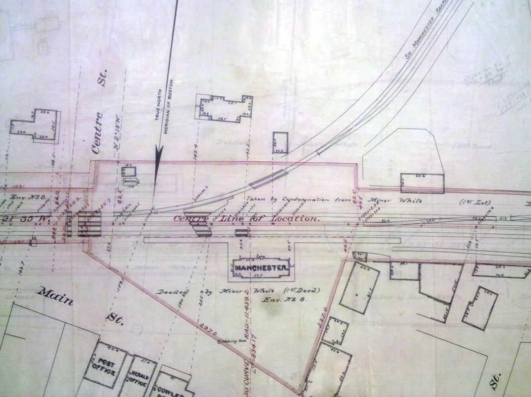
MANCHESTER2 [NY&NE, 1881]
The upper left photo is a ca. 1930 Benton and Drake. The image at upper middle is from an 1891 NY&NE real estate atlas. The 1893 map at upper right shows the station in Depot Square, as well as the wye for the South Manchester RR. This station, flanked by its distinctive wings, was reportedly constructed using the frame of the previous depot and was described as being in the Queen Anne style and about 25x72 feet in size. The wings are reminiscent of DANBURY3, which was built by Leman Oatman of Hartford also in 1881 and this may be his work as well. MANCHESTER2 served passengers until 1957. Demolition began on 8/10/1962 and was completed by 8/14. The NYNH&H paid $3,000 to raze the structure so that the land, to be used thereafter for a parking lot, could be sold to the town for $35,000. [REFS: HDC/04/15/1881/02; 5/25/1881/01; HC/08/14/1962/22C; M98??: 1957][rev090313]
The upper left photo is a ca. 1930 Benton and Drake. The image at upper middle is from an 1891 NY&NE real estate atlas. The 1893 map at upper right shows the station in Depot Square, as well as the wye for the South Manchester RR. This station, flanked by its distinctive wings, was reportedly constructed using the frame of the previous depot and was described as being in the Queen Anne style and about 25x72 feet in size. The wings are reminiscent of DANBURY3, which was built by Leman Oatman of Hartford also in 1881 and this may be his work as well. MANCHESTER2 served passengers until 1957. Demolition began on 8/10/1962 and was completed by 8/14. The NYNH&H paid $3,000 to raze the structure so that the land, to be used thereafter for a parking lot, could be sold to the town for $35,000. [REFS: HDC/04/15/1881/02; 5/25/1881/01; HC/08/14/1962/22C; M98??: 1957][rev090313]

MANSFIELD1 [NLW&P, 1850]
The location is as seen on the 1857TC map. The stop was established in 1850 when the NLW&P opened.
The location is as seen on the 1857TC map. The stop was established in 1850 when the NLW&P opened.

|
|
|
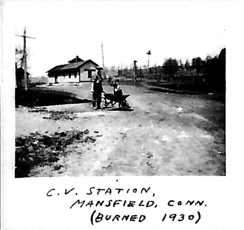
MANSFIELD2 [NLN, c1880?]
We are not sure when this station debuted but it burned in 1930. [REFS: HC/02/08/1916/04]
We are not sure when this station debuted but it burned in 1930. [REFS: HC/02/08/1916/04]

|

|
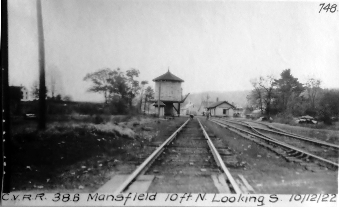
MANSFIELD3 [CVT, 1930]
The Benton & Drake photo at left says this station opened on 6/16/1930 and we are thinking that the only way they knew that was to have taken this shot sometime shortly thereafter. John Roy tells us that a fire on 7/2/2003 destroyed the building which was still owned by the railroad but had been rented out as The Depot restaurant since 1978. [REFS: HC/07/13/2003/B1; C82; R307]
The Benton & Drake photo at left says this station opened on 6/16/1930 and we are thinking that the only way they knew that was to have taken this shot sometime shortly thereafter. John Roy tells us that a fire on 7/2/2003 destroyed the building which was still owned by the railroad but had been rented out as The Depot restaurant since 1978. [REFS: HC/07/13/2003/B1; C82; R307]
ICC Collection / National Archives
|

|
|
Archives & Special Collections, UConn
|
|
|

Archives & Special Collections, UConn
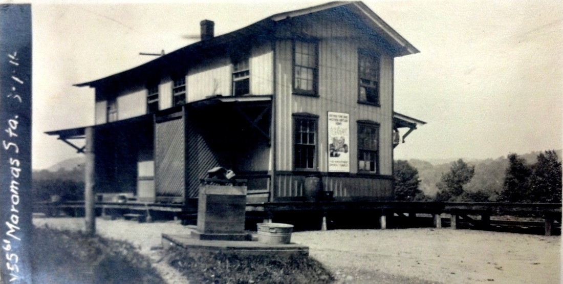
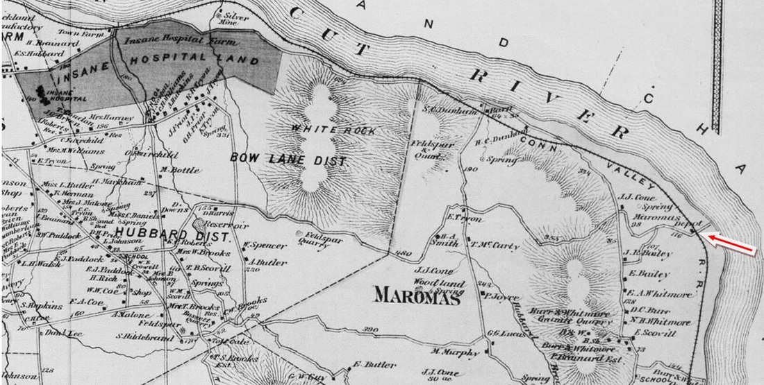
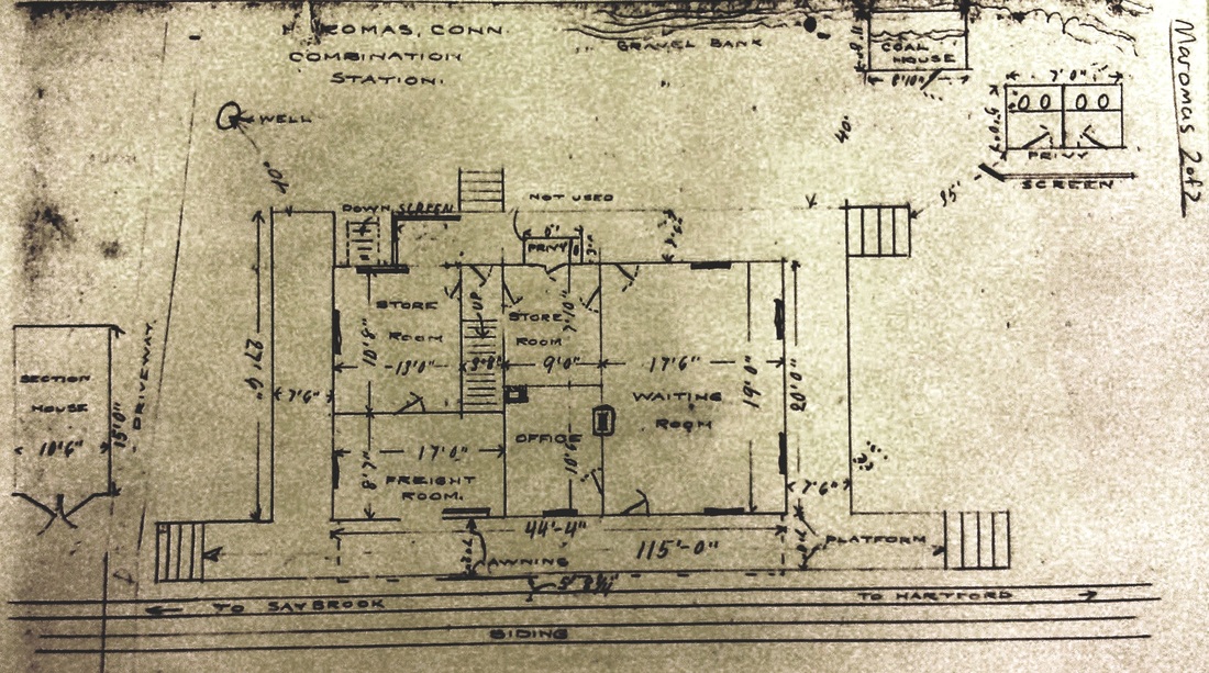
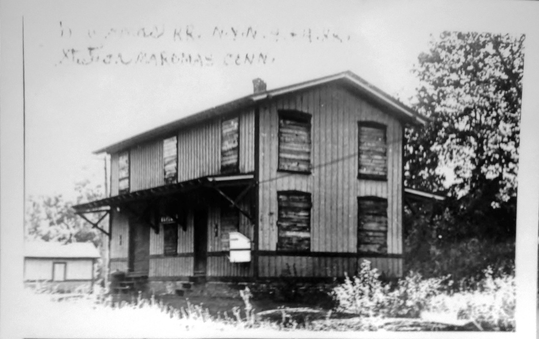
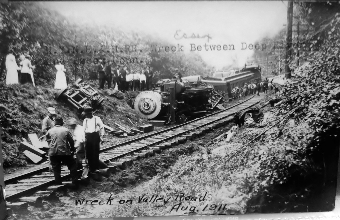
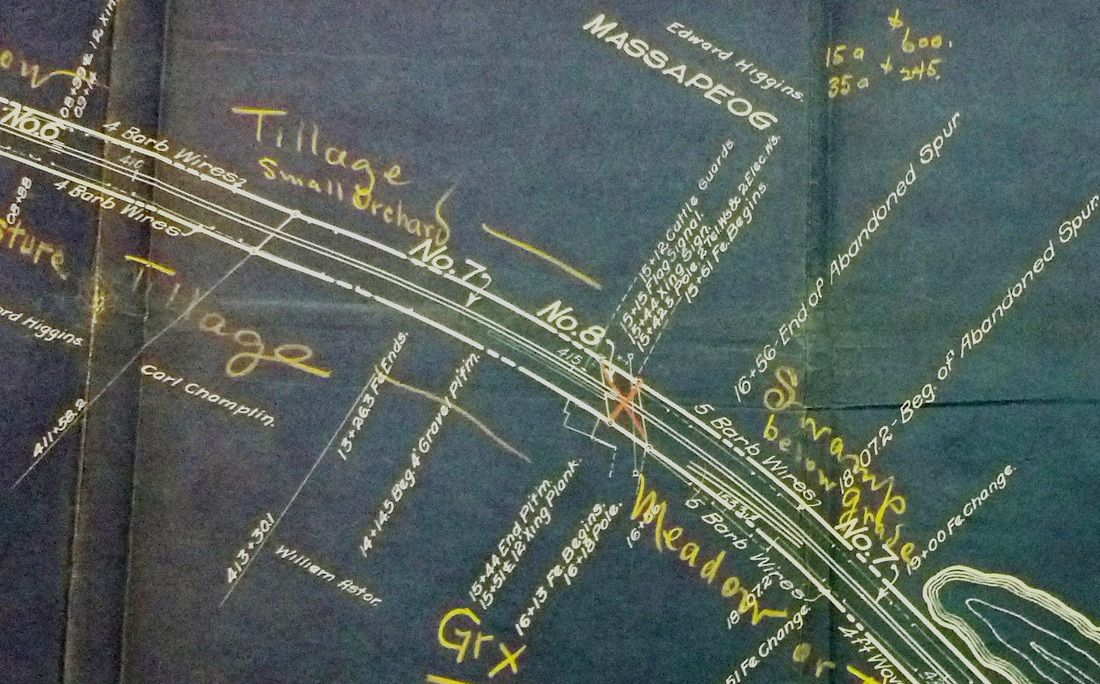
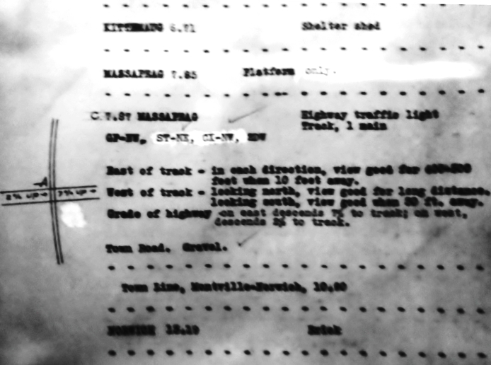
MAROMAS [CV, 1871]
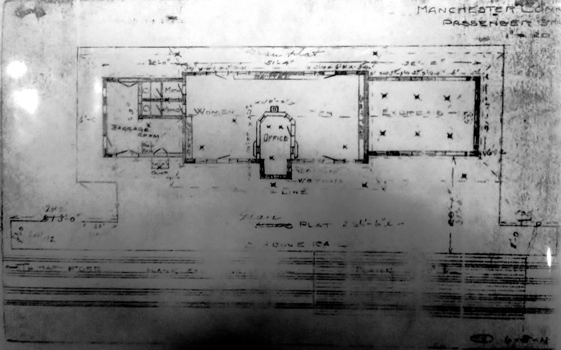
The val photo at [1] captured the station in 1916, and the 1915 val map at [2] shows that it stood in the northwest quadrant of the Depot Rd. grade crossing. This southern part of Middletown may have been settled as early as 1696 and the first farm is said to have dated to 1722. The name may derive from the Algonquian word meaning 'bare' that applies to this rocky, forested locale. Indeed, the 1874 Beers atlas at [3] shows the pockets of feldspar, granite and silver, the latter reportedly mined back to the Revolutionary War at the location seen on the map. Nevertheless the area supported agriculture as well and the community was frequently mentioned in the newspapers for its religious, civic and social activities. In 1871 when the CV opened, the railroad certainly felt that it merited a station, the floor plan of which is seen at [4]. The image at [5] shows the station abandoned, possibly in the 1930s after passenger service on the CV ended. This area has had its share of notoriety over the years, foremost among which were two spectacular train derailments, almost exactly a year apart, on 8/12/1910 and 8/27/1911 at [6]. This rugged corner of Middletown has hosted the state mental health facility, now eerily closed for the most part, a 1950s HELCO power plant operated today by Eversource, and the Connecticut Atomic Nuclear Engine Laboratory [C.A.N.E.L] project, a Cold War-era effort to build nuclear-powered aircraft that was scuttled in 1961. Pratt & Whitney inherited the property which is the large complex on the CTTRAXMAP snippet at [7]. The faintly seen Depot Rd. once took a left and descended down to river, whence a ferry plied the waters over to the landing that is still visible on the Middle Haddam side. We have more on this fascinating area in our BENVENUE entry for the station just north of here. [REFS: HDC/08/25/1871/02; DC/09/21/1872/02; DN/10/29/1913/12; HC/11/29/1954/10E; HC/04/10/1955/A10B; K98][rev050317, 083019]
The val photo at [1] captured the station in 1916, and the 1915 val map at [2] shows that it stood in the northwest quadrant of the Depot Rd. grade crossing. This southern part of Middletown may have been settled as early as 1696 and the first farm is said to have dated to 1722. The name may derive from the Algonquian word meaning 'bare' that applies to this rocky, forested locale. Indeed, the 1874 Beers atlas at [3] shows the pockets of feldspar, granite and silver, the latter reportedly mined back to the Revolutionary War at the location seen on the map. Nevertheless the area supported agriculture as well and the community was frequently mentioned in the newspapers for its religious, civic and social activities. In 1871 when the CV opened, the railroad certainly felt that it merited a station, the floor plan of which is seen at [4]. The image at [5] shows the station abandoned, possibly in the 1930s after passenger service on the CV ended. This area has had its share of notoriety over the years, foremost among which were two spectacular train derailments, almost exactly a year apart, on 8/12/1910 and 8/27/1911 at [6]. This rugged corner of Middletown has hosted the state mental health facility, now eerily closed for the most part, a 1950s HELCO power plant operated today by Eversource, and the Connecticut Atomic Nuclear Engine Laboratory [C.A.N.E.L] project, a Cold War-era effort to build nuclear-powered aircraft that was scuttled in 1961. Pratt & Whitney inherited the property which is the large complex on the CTTRAXMAP snippet at [7]. The faintly seen Depot Rd. once took a left and descended down to river, whence a ferry plied the waters over to the landing that is still visible on the Middle Haddam side. We have more on this fascinating area in our BENVENUE entry for the station just north of here. [REFS: HDC/08/25/1871/02; DC/09/21/1872/02; DN/10/29/1913/12; HC/11/29/1954/10E; HC/04/10/1955/A10B; K98][rev050317, 083019]
MARSHALLS CORNERS [> SOUND BEACH1]
MASONVILLE [> GROSVENORDALE]
MASONVILLE [> GROSVENORDALE]

|

|

University of Vermont Special Collections
|
National Archives
|
Max Miller Collection
|
|
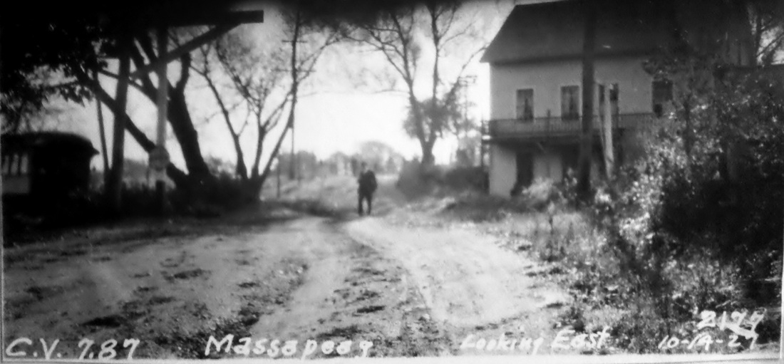
MASSAPEAG1 [NLW&P, 1849]
This was established as a regular timetable stop in the town of Montville probably from the 1849 opening of the NLW&P and, as such, appears on the 1854NL map at [2]. The 1883 NLN map at [3] shows the platform and seems to corroborate the shape of the building in the photo at [1], which looks more like a tavern or residence in which depot space was rented or where people, like the gentleman on the stairs to the right, just waited for the train. The 1917 val map at [4] shows the building and the platform. The PUC notes which Max Miller rescued for posterity at [6], possibly corresponding to the 10/14/1927 date of the photo at [5], say that there is a only a platform here, which is seen in the foreground. The name of this station means 'great-water land' or 'land on the great cove,' that body of water being Massapeag, aka Haughton's Cove, today Horton Cove, just to the south of the promontory. [REFS: NLDC/10/26/1852/01; NLDC/09/30/1853/01; NLDC/01/25/1859/02; NLDC/11/22/1859/02; NMB/08/18/1876/04; NHER/07/11/1887/01; HDC/11/20/1865/02][rev050317]
This was established as a regular timetable stop in the town of Montville probably from the 1849 opening of the NLW&P and, as such, appears on the 1854NL map at [2]. The 1883 NLN map at [3] shows the platform and seems to corroborate the shape of the building in the photo at [1], which looks more like a tavern or residence in which depot space was rented or where people, like the gentleman on the stairs to the right, just waited for the train. The 1917 val map at [4] shows the building and the platform. The PUC notes which Max Miller rescued for posterity at [6], possibly corresponding to the 10/14/1927 date of the photo at [5], say that there is a only a platform here, which is seen in the foreground. The name of this station means 'great-water land' or 'land on the great cove,' that body of water being Massapeag, aka Haughton's Cove, today Horton Cove, just to the south of the promontory. [REFS: NLDC/10/26/1852/01; NLDC/09/30/1853/01; NLDC/01/25/1859/02; NLDC/11/22/1859/02; NMB/08/18/1876/04; NHER/07/11/1887/01; HDC/11/20/1865/02][rev050317]

Montville Historical Society
MASSAPEAG2 [CVT, c1930?]
The style of dress the woman displays makes it likely that this simple shelter was put up in the late 1920s or 1930s for CVT riders. Passenger service lasted until 1947, and, according to one source, consisted of a coach on a freight train in the final year. [REFS: NLD/04/28/1953/24][rev050317]
The style of dress the woman displays makes it likely that this simple shelter was put up in the late 1920s or 1930s for CVT riders. Passenger service lasted until 1947, and, according to one source, consisted of a coach on a freight train in the final year. [REFS: NLD/04/28/1953/24][rev050317]
|

|
|
MECHANICSVILLE1 [B&NYC, 1854]
This stop was created in the town of Thompson when the Boston and New York Central built its East Thompson RR branch to a connection with the N&W in 1854. The 1858TT at left shows this station as THOMPSON JUNCTION. On others it is seen just as JUNCTION and still others as MECHANICSVILLE. The location is seen on the 1856WC map at middle with the depot between the tracks and serving both roads as a transfer point. This would remain a terminus into the BH&E era until late 1868 when that road extended the track to PUTNAM. The crossover, just below the village, was sanctioned by the railroad commissioners in January, 1869, and is seen on the map of that year at right. In 1875, Charles Peter Clark, general manager of the successor NY&NE, petitioned the railroad commissioners to discontinue this station and, after no objections were voiced at a hearing on 1/19/1876, the request was granted. With the 1865 MECHANICSVILLE2 open just north of the junction and the NY&NE controlling both lines, this depot was undoubtedly seen as superfluous and may have been in disuse already. Presumably, passengers caught the appropriate train at PUTNAM and there was no longer a need for transfers at the junction. Clark locates the depot correctly as 1.7 miles or so above Putnam and describes it as "a small affair, originally put up for the convenience of Miss Sayles, who now assent (sic) to the discontinuance." As late as 1877, the NY&NE is said to have been amenable to moving MECHANICSVILLE1 to HAMPTON where the railroad commissioners had received complaints about the need for better accommodations. There is no evidence either way that this was done. The venerable Miss Sayles notwithstanding, Clark's acceptance of the fable is rather perplexing when the station had indeed served an important purpose for the past two decades. We have no photo of this erstwhile station structure. [REFS: CRC1.1854.11; PTH107.1858.9; RRC6.210 (1/26/1869); NA/06/17/1868/04; NA/11/18/1868/04; CRC23.1876.27; RRL1/8/1877; SL12.2.7][rev050317]
This stop was created in the town of Thompson when the Boston and New York Central built its East Thompson RR branch to a connection with the N&W in 1854. The 1858TT at left shows this station as THOMPSON JUNCTION. On others it is seen just as JUNCTION and still others as MECHANICSVILLE. The location is seen on the 1856WC map at middle with the depot between the tracks and serving both roads as a transfer point. This would remain a terminus into the BH&E era until late 1868 when that road extended the track to PUTNAM. The crossover, just below the village, was sanctioned by the railroad commissioners in January, 1869, and is seen on the map of that year at right. In 1875, Charles Peter Clark, general manager of the successor NY&NE, petitioned the railroad commissioners to discontinue this station and, after no objections were voiced at a hearing on 1/19/1876, the request was granted. With the 1865 MECHANICSVILLE2 open just north of the junction and the NY&NE controlling both lines, this depot was undoubtedly seen as superfluous and may have been in disuse already. Presumably, passengers caught the appropriate train at PUTNAM and there was no longer a need for transfers at the junction. Clark locates the depot correctly as 1.7 miles or so above Putnam and describes it as "a small affair, originally put up for the convenience of Miss Sayles, who now assent (sic) to the discontinuance." As late as 1877, the NY&NE is said to have been amenable to moving MECHANICSVILLE1 to HAMPTON where the railroad commissioners had received complaints about the need for better accommodations. There is no evidence either way that this was done. The venerable Miss Sayles notwithstanding, Clark's acceptance of the fable is rather perplexing when the station had indeed served an important purpose for the past two decades. We have no photo of this erstwhile station structure. [REFS: CRC1.1854.11; PTH107.1858.9; RRC6.210 (1/26/1869); NA/06/17/1868/04; NA/11/18/1868/04; CRC23.1876.27; RRL1/8/1877; SL12.2.7][rev050317]
|
|

|

|
|

|
MECHANICSVILLE2 [N&W, 1865]
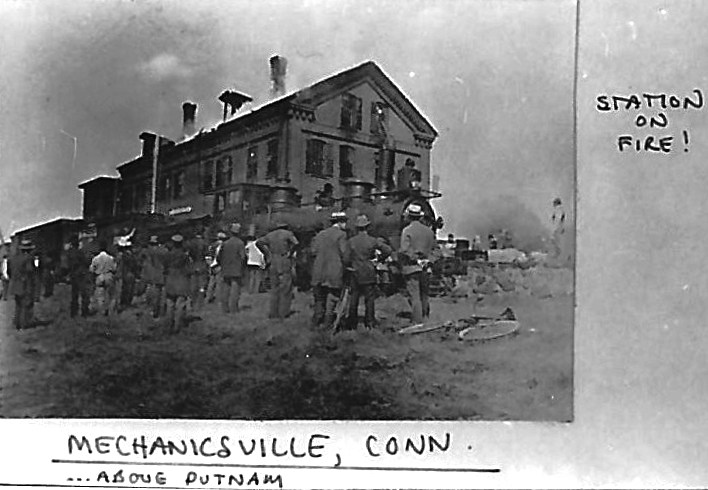
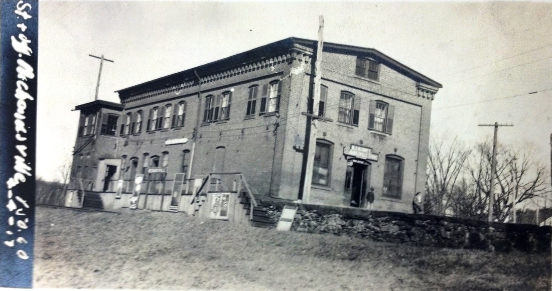
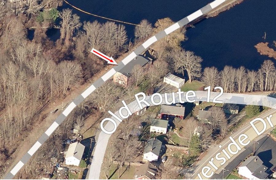
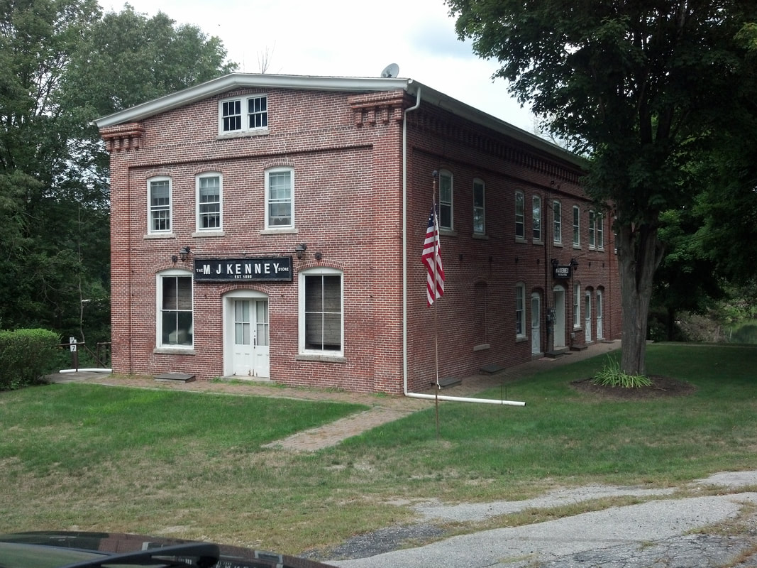
The newspaper said in 1865 that the Mechanicsville Co. of Putnam was erecting "a nice new building in their village near the railroad," to be used as a depot, store, office, and tenement for workers at the company's new mill. This location was at the company's mill pond about a quarter of a mile north of the junction with the N&W. Though the wording is vague, having this mean that this depot was here and not at Putnam would explain how the abandoned MECHANICSVILLE1 could have been considered for use at HAMPTON, as noted in our previous entry. The image at [1] appears to be the "nice new building" at a later date when it caught fire, ca. 1888 according to the Thompson Historical Society. It survived, with a lowered roof, as seen in the 4/4/1917 val photo at [2]. The 1915 val map at [3] shows the station footprint at that time. The NY&NE track is seen at the top of the map coming in from the east and about to parallel the N&W to PUTNAM. The 1893 topographic map at [4] shows that the crossover which allowed the NY&NE to go west to WILLIMANTIC has been relocated to PUTNAM. MECHANICSVILLE2 was later known as M.J. Kenney's store where he sold dry goods and handled the mail for the post office which was established on 4/2/1873 and lasted until 1983. As often was the case at the time, Kenney presumably wore four hats: station agent, telegrapher, postmaster and shopkeeper. MECHANICSVILLE2 still stands today, as shown in the aerial map at [5]. The matching freight depot, no longer extant, is shown at [6] in another 4/4/1917 val photo. At [7] is our photo of the 'Kenney Store' on 8/8/2013. Sources at the Thompson Historical Society tell us that the Kenney family will be donating the post office preserved inside and other artifacts to THS in the near future. [REFS: HDC/10/02/1865/02][rev050317, 062019]
The newspaper said in 1865 that the Mechanicsville Co. of Putnam was erecting "a nice new building in their village near the railroad," to be used as a depot, store, office, and tenement for workers at the company's new mill. This location was at the company's mill pond about a quarter of a mile north of the junction with the N&W. Though the wording is vague, having this mean that this depot was here and not at Putnam would explain how the abandoned MECHANICSVILLE1 could have been considered for use at HAMPTON, as noted in our previous entry. The image at [1] appears to be the "nice new building" at a later date when it caught fire, ca. 1888 according to the Thompson Historical Society. It survived, with a lowered roof, as seen in the 4/4/1917 val photo at [2]. The 1915 val map at [3] shows the station footprint at that time. The NY&NE track is seen at the top of the map coming in from the east and about to parallel the N&W to PUTNAM. The 1893 topographic map at [4] shows that the crossover which allowed the NY&NE to go west to WILLIMANTIC has been relocated to PUTNAM. MECHANICSVILLE2 was later known as M.J. Kenney's store where he sold dry goods and handled the mail for the post office which was established on 4/2/1873 and lasted until 1983. As often was the case at the time, Kenney presumably wore four hats: station agent, telegrapher, postmaster and shopkeeper. MECHANICSVILLE2 still stands today, as shown in the aerial map at [5]. The matching freight depot, no longer extant, is shown at [6] in another 4/4/1917 val photo. At [7] is our photo of the 'Kenney Store' on 8/8/2013. Sources at the Thompson Historical Society tell us that the Kenney family will be donating the post office preserved inside and other artifacts to THS in the near future. [REFS: HDC/10/02/1865/02][rev050317, 062019]
MELROSE1 [CC, 1876]
This stop in the town of EAST WINDSOR was established with the opening of the Connecticut Central in 1876. The first station burned and was replaced in 1897. We have no photo yet. The NY&NE real estate map dates to 1888. [REFS: MDC/05/06/1876/02; HC/06/25/1896/05; NHER/02/28/1896/02][rev021014]
This stop in the town of EAST WINDSOR was established with the opening of the Connecticut Central in 1876. The first station burned and was replaced in 1897. We have no photo yet. The NY&NE real estate map dates to 1888. [REFS: MDC/05/06/1876/02; HC/06/25/1896/05; NHER/02/28/1896/02][rev021014]

|
|

|
 National Archives
MELROSE2 [NYNH&H, 1897]
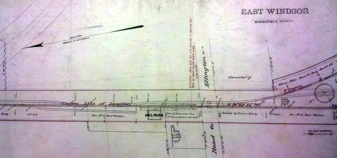
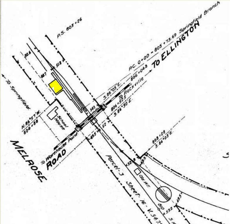
This new station was built in 1897 after the old one burned. The image at [1] is a Lewis H. Benton shot #2362, probably from 1927, with Irving Drake's sedan front and center. The 1915 val map at [2] has the depot in the northwest quadrant of the Ellington Rd. grade crossing and shows the layout of the station grounds, including the turntable and the Melrose branch track. The heavy dashed line is the Rockville, Broad Brook & East Windsor Street Rwy that opened in 1906 from Warehouse Point to Rockville, with a car on the bridge seen in the shot at [3]. The image at [4] is an 8/7/1916 val photo of MELROSE2. From 1908 to 1914 there were electric cars on the Melrose branch as part of the Rockville interurban service. By 1928 when branch service was ending, there was a hearing on the NYNH&H's intended closing of this station, in spite of service on the CC being continued into the late 1930s before conversion to bus. The PUC granted the public's request for the station, also the post office, to remain open in spite of the fact that this would no longer be a junction point for trains to ROCKVILLE. [REFS: CRC45.1897.23; HC/08/08/1928/05][rev050317]
This new station was built in 1897 after the old one burned. The image at [1] is a Lewis H. Benton shot #2362, probably from 1927, with Irving Drake's sedan front and center. The 1915 val map at [2] has the depot in the northwest quadrant of the Ellington Rd. grade crossing and shows the layout of the station grounds, including the turntable and the Melrose branch track. The heavy dashed line is the Rockville, Broad Brook & East Windsor Street Rwy that opened in 1906 from Warehouse Point to Rockville, with a car on the bridge seen in the shot at [3]. The image at [4] is an 8/7/1916 val photo of MELROSE2. From 1908 to 1914 there were electric cars on the Melrose branch as part of the Rockville interurban service. By 1928 when branch service was ending, there was a hearing on the NYNH&H's intended closing of this station, in spite of service on the CC being continued into the late 1930s before conversion to bus. The PUC granted the public's request for the station, also the post office, to remain open in spite of the fact that this would no longer be a junction point for trains to ROCKVILLE. [REFS: CRC45.1897.23; HC/08/08/1928/05][rev050317]

MERIDEN/H1,H3 [H&NH, 1838]
The first depot was at a hotel in what was called the Rogers Block, south of Main St. and on the west side of the track, as shown on the 1852NH map. The first passengers had to disembark below Harbor Brook and walk to the station until the railroad built a bridge for trains to cross the waterway. The depot in the Rogers Block was resurrected after the next one in the Conklin Hotel burned in the mid-1840s and served until MERIDEN/H4 opened in 1854. [rev081413]
The first depot was at a hotel in what was called the Rogers Block, south of Main St. and on the west side of the track, as shown on the 1852NH map. The first passengers had to disembark below Harbor Brook and walk to the station until the railroad built a bridge for trains to cross the waterway. The depot in the Rogers Block was resurrected after the next one in the Conklin Hotel burned in the mid-1840s and served until MERIDEN/H4 opened in 1854. [rev081413]

MERIDEN/H2 [H&NH, c1842]
Note the early H&NH open-cab locomotive and the sign for the 'Railroad Refectory,' the station waiting room in the addition that the H&NH put on the hotel that is seen behind the train. This building was known first as the Meriden Hotel, as this 1842 woodcut is dated, and would later become the Conklin Hotel. Rockey and some other sources say that the first station was in the Rogers block. That was also a hotel, just out of sight to the left on the south side of Main St., which would serve as a station later when the Conklin Hotel burned in the mid-1840s. [rev112018]
Note the early H&NH open-cab locomotive and the sign for the 'Railroad Refectory,' the station waiting room in the addition that the H&NH put on the hotel that is seen behind the train. This building was known first as the Meriden Hotel, as this 1842 woodcut is dated, and would later become the Conklin Hotel. Rockey and some other sources say that the first station was in the Rogers block. That was also a hotel, just out of sight to the left on the south side of Main St., which would serve as a station later when the Conklin Hotel burned in the mid-1840s. [rev112018]

MERIDEN/H4 [H&NH, 1854]
This 1875 Bailey map [click here] shows the 1854 station above locator number '3' as of this date, at what would later be the corner of Railroad Ave. and Colony St. The wooden structure burned in an 1862 fire, was rebuilt with a brick facade, and survived another fire in 1864. The freight depot on the map across the track is standing more or less in its original location, before being moved north to make room for the later passenger stations. Main St. crosses the tracks to the far right. The '50' marks where MERIDEN2 in the Conklin Hotel stood before it burned and '51' denotes the Rogers Block that served as MERIDEN3. [REFS: HC/11/13/1862/02][rev081413]
This 1875 Bailey map [click here] shows the 1854 station above locator number '3' as of this date, at what would later be the corner of Railroad Ave. and Colony St. The wooden structure burned in an 1862 fire, was rebuilt with a brick facade, and survived another fire in 1864. The freight depot on the map across the track is standing more or less in its original location, before being moved north to make room for the later passenger stations. Main St. crosses the tracks to the far right. The '50' marks where MERIDEN2 in the Conklin Hotel stood before it burned and '51' denotes the Rogers Block that served as MERIDEN3. [REFS: HC/11/13/1862/02][rev081413]

|
|

|
MERIDEN/H5 [NYNH&H, 1882]
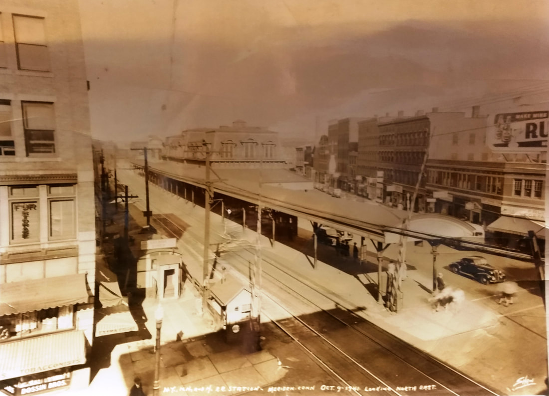
Opened September, 1882; similar to WALLINGFORD2 and NEW HAVEN4, reportedly 185 feet in length and with 19 rooms upstairs. Razed c1942. The photo at [4] is dated 10/9/1941, probably the last shot ever taken. [REFS: NHJC/04/15/1881/02; CRC30.1883.23; NHAR10.1882.6][rev092819, 110320]

|
|
|
MERIDEN/H6 [NYNH&H, 1942]
Opened 9/21/1942; razed 1971.
Opened 9/21/1942; razed 1971.
|
|
|
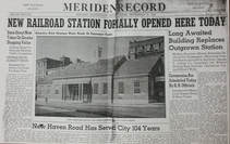
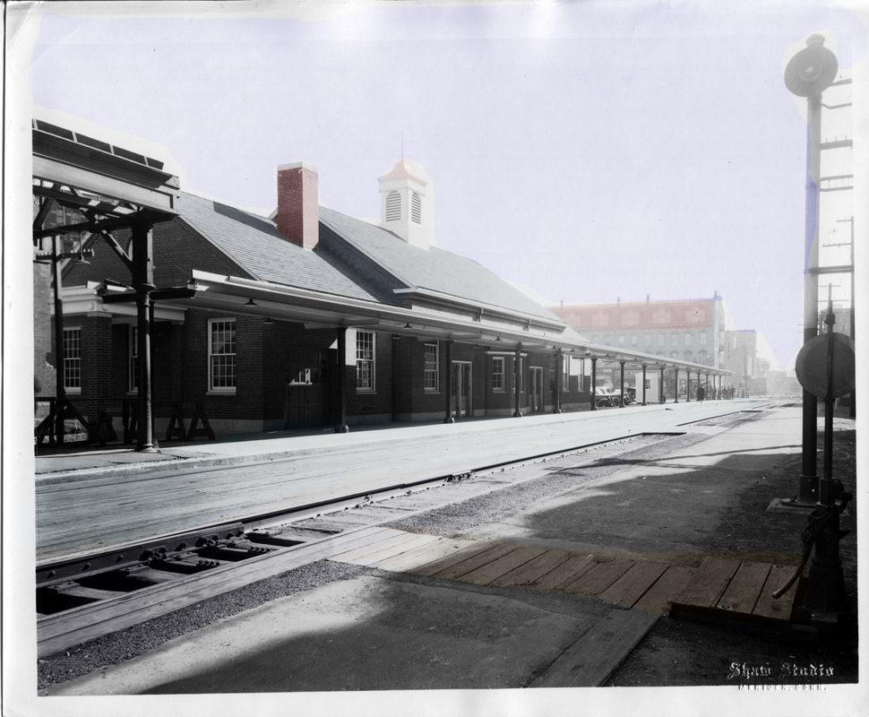
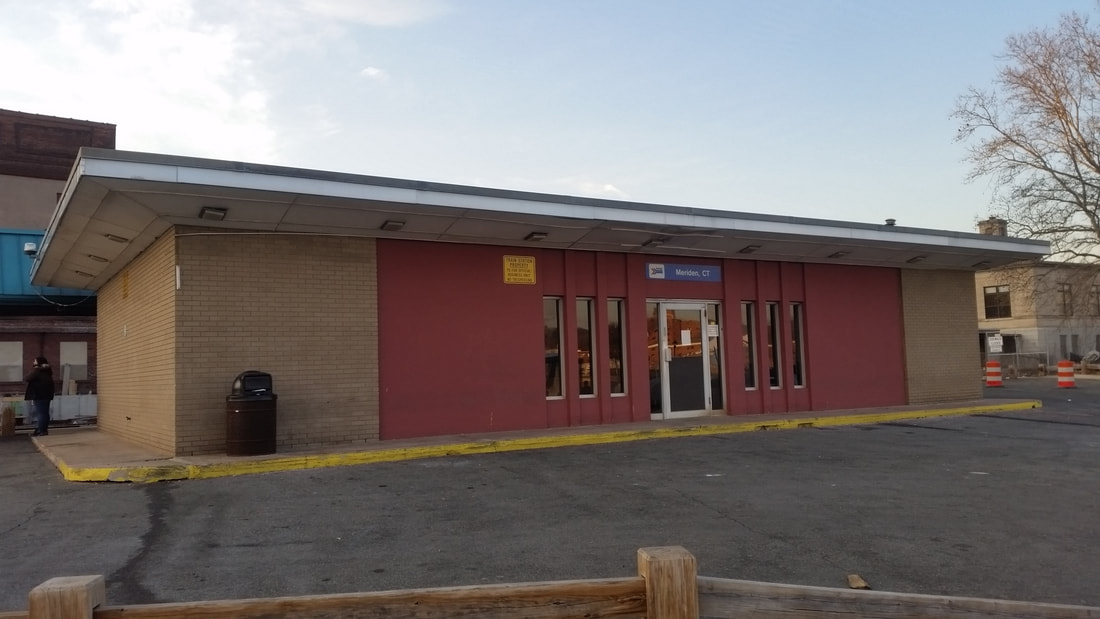
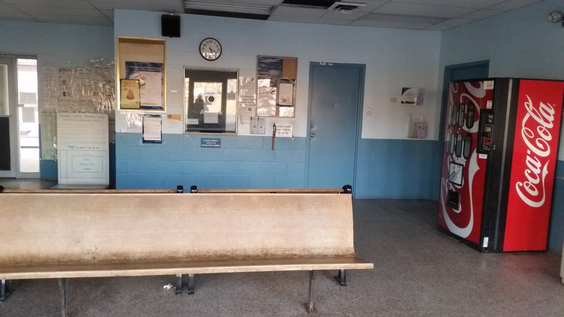
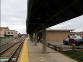
MERIDEN/H7 [PC, 1970]
This station was opened in 1970 by Penn Central and razed in 2016. [add112018]
This station was opened in 1970 by Penn Central and razed in 2016. [add112018]
 Wikipedia
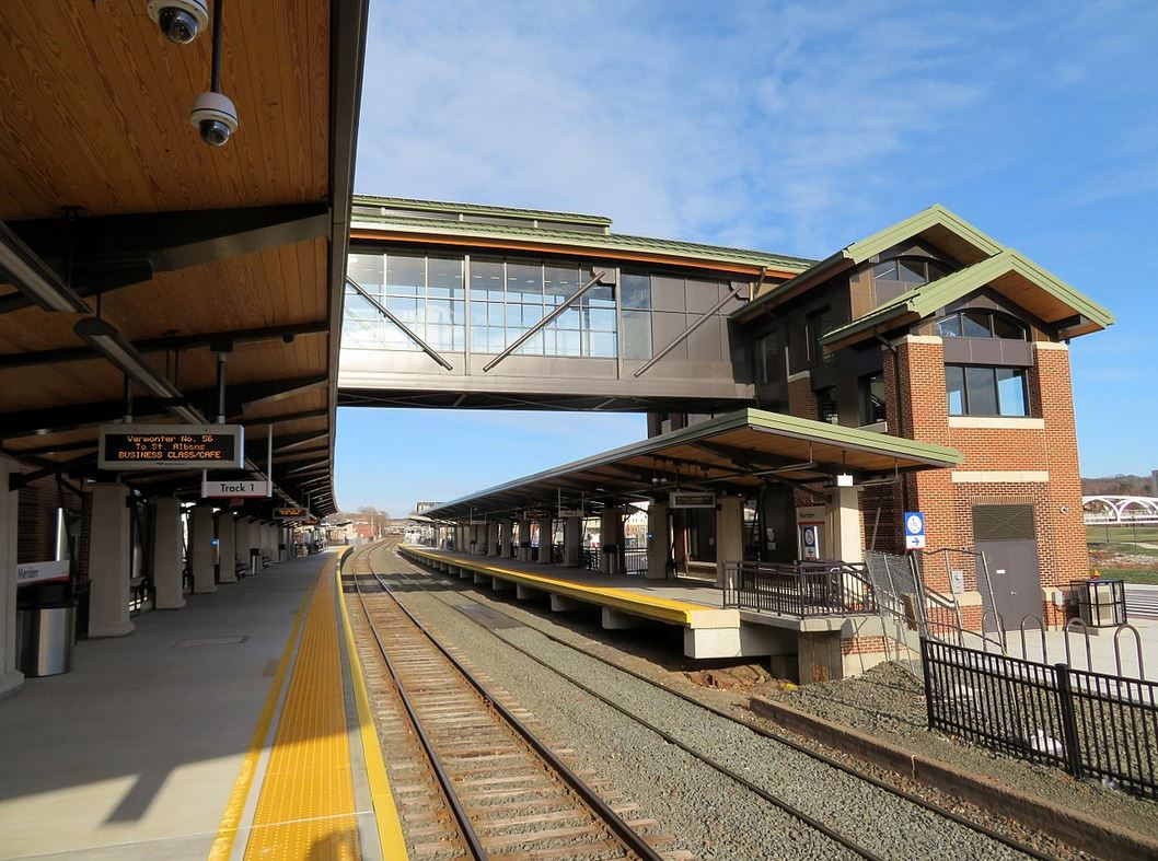
MERIDEN/H8 [CDOT, 2016]
|
|
|
MERIDEN/M1 [M&C, 1885]
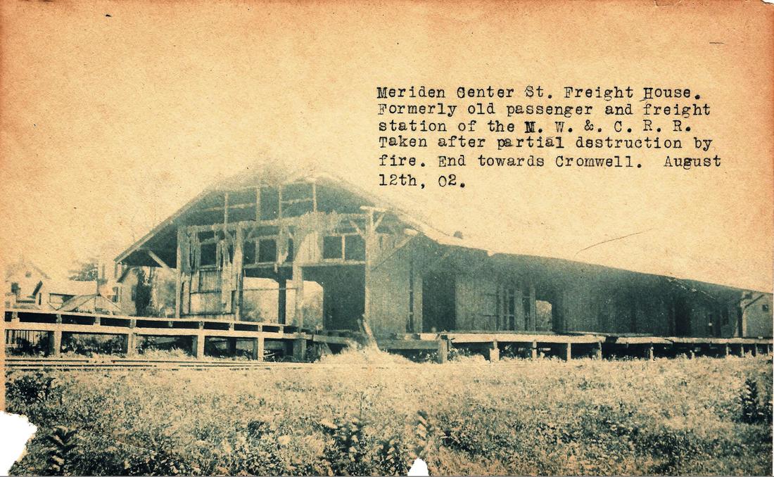
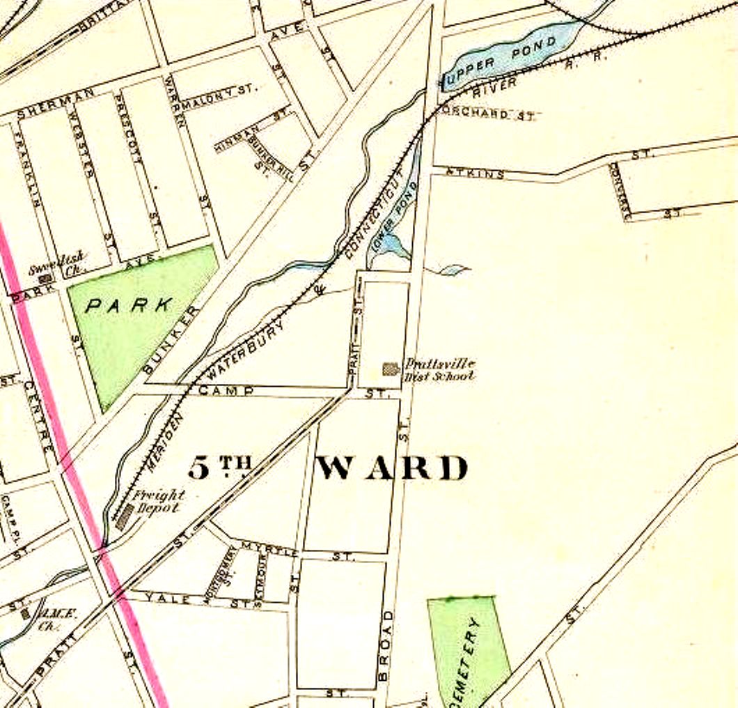
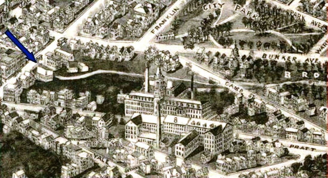
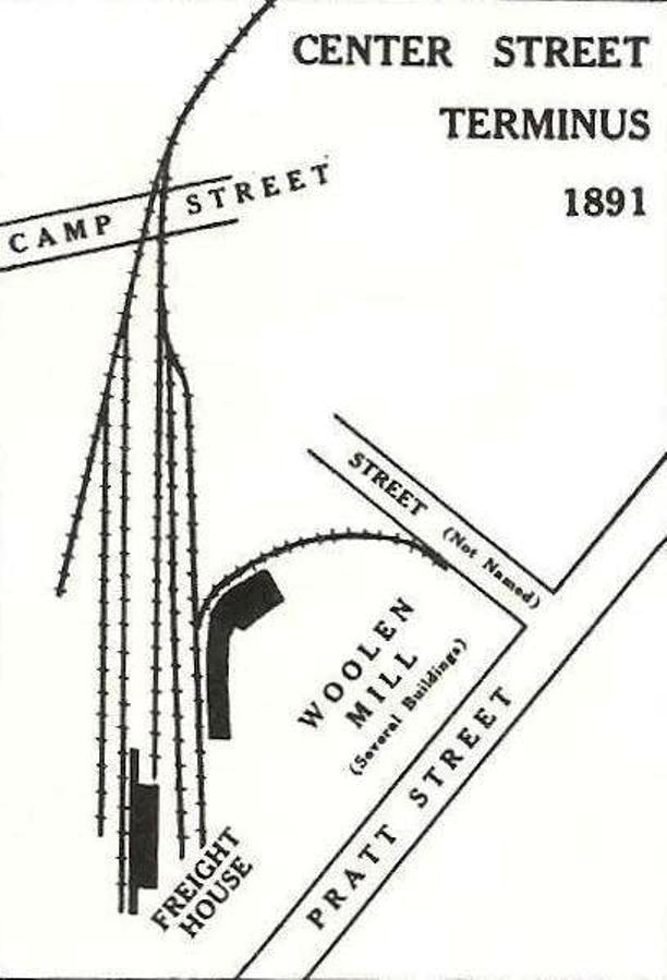
This was the depot opened by the Meriden and Cromwell RR on Center St., just off Main St., in 1885 and served as its freight and passenger terminus. The photo at [1] was taken on 8/12/1902 after fire damage; this is the only photo we have ever seen of this structure. The map at [2] is from 1893 and the snippet at [3] is from the 1918 aero map [click here]. The map at [4] is from Snow's history of the MW&CR. [REFS: S14][rev083019]
This was the depot opened by the Meriden and Cromwell RR on Center St., just off Main St., in 1885 and served as its freight and passenger terminus. The photo at [1] was taken on 8/12/1902 after fire damage; this is the only photo we have ever seen of this structure. The map at [2] is from 1893 and the snippet at [3] is from the 1918 aero map [click here]. The map at [4] is from Snow's history of the MW&CR. [REFS: S14][rev083019]
|
|
|
|
Meriden Historical Society
|

|
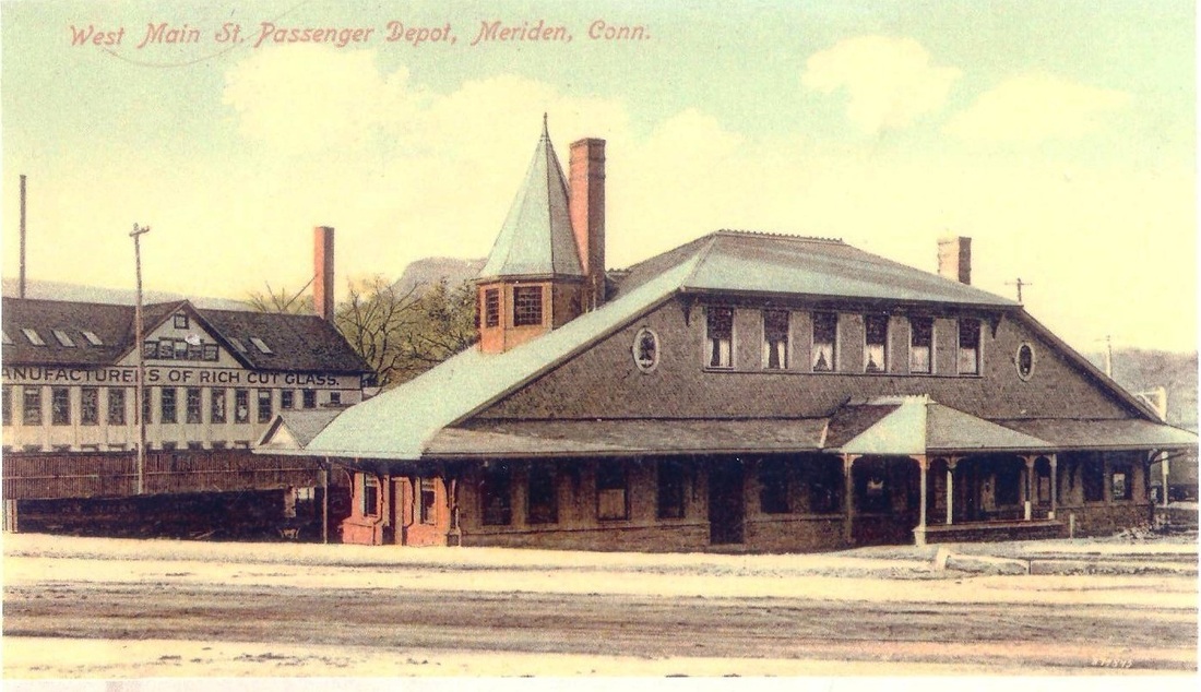
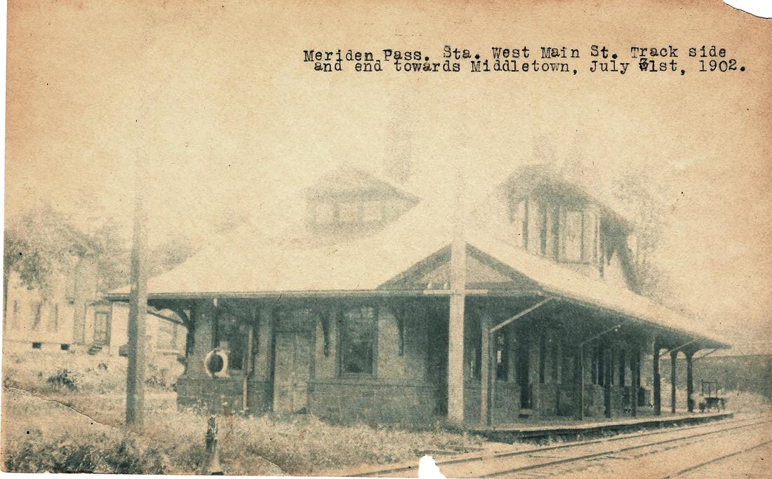
MERIDEN/M2 [MW&CR, 1889]
The MW&CR opened in July, 1888 and first used a temporary depot here on West Main St. Glover Snow says that this impressive structure was "put into use" on 6/17/1889 and that track was still in place to serve nearby factory sidings when he was writing in 1953. The 1938 SSRR list says the depot was sold upon an offer of $175.00; the handwritten name may read T. Ellison. It was partly rented at the time and the Meriden Motorcycle Club was a tenant. The station seems to have come down with the demolition of the West Main St. bridge in 1940 but we have been unable to find an actual mention in the newspapers. [REFS: S15,27][rev010318]
The MW&CR opened in July, 1888 and first used a temporary depot here on West Main St. Glover Snow says that this impressive structure was "put into use" on 6/17/1889 and that track was still in place to serve nearby factory sidings when he was writing in 1953. The 1938 SSRR list says the depot was sold upon an offer of $175.00; the handwritten name may read T. Ellison. It was partly rented at the time and the Meriden Motorcycle Club was a tenant. The station seems to have come down with the demolition of the West Main St. bridge in 1940 but we have been unable to find an actual mention in the newspapers. [REFS: S15,27][rev010318]
|
|

|
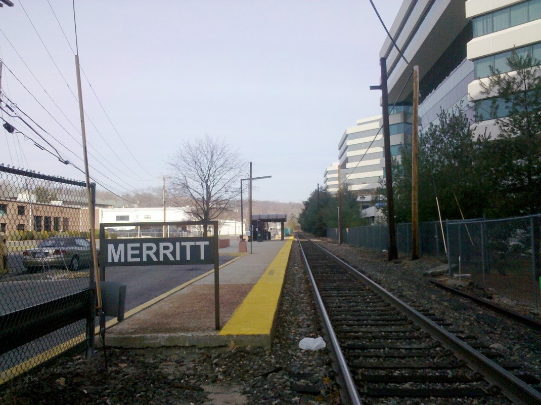
MERRITT 7 [MN, 1985]
This northern Norwalk stop was established on 7/29/1985 and was touted by the New York Times as being the only privately built station in the state. That was probably true of existing stations still in service then, but the comment certainly ignores the fact that many stations in Connecticut were built by towns and individuals and given to the railroads to guarantee service at a particular location. Still, this was an innovative move to spur corporate and residential growth here where Norwalk Tire and Rubber once had a sizeable presence with a stop called OAKWOOD AVENUE and later the Caldor's department store chain had its administrative offices. A comparison of the 2010 photos at left and middle with the earlier shot at right shows the growth in this corporate enclave with a combination of refurbished buildings and new construction. A Wilton Bulletin article in 1994 touted the renovation that ConnDOT had done here, including improved parking area, lighting, telephone booth, and the shelter itself. The KENT ROAD stop about a mile north was discontinued at that time as a result. [REFS: NYT/07/28/1985/11/3; WB/01/12/1994/02; P95+][rev050317]
This northern Norwalk stop was established on 7/29/1985 and was touted by the New York Times as being the only privately built station in the state. That was probably true of existing stations still in service then, but the comment certainly ignores the fact that many stations in Connecticut were built by towns and individuals and given to the railroads to guarantee service at a particular location. Still, this was an innovative move to spur corporate and residential growth here where Norwalk Tire and Rubber once had a sizeable presence with a stop called OAKWOOD AVENUE and later the Caldor's department store chain had its administrative offices. A comparison of the 2010 photos at left and middle with the earlier shot at right shows the growth in this corporate enclave with a combination of refurbished buildings and new construction. A Wilton Bulletin article in 1994 touted the renovation that ConnDOT had done here, including improved parking area, lighting, telephone booth, and the shelter itself. The KENT ROAD stop about a mile north was discontinued at that time as a result. [REFS: NYT/07/28/1985/11/3; WB/01/12/1994/02; P95+][rev050317]

|

|
MERROW1 [NLW&P, 1850]
This stop in the town of Mansfield was established in 1850 by the NLW&P. The location is seen on the 1857TC map with the village called Merrowville. We do not see any signboard but this structure is accepted as the station, probably the first although the details here are sketchy. An entry in the journal of Mansfield resident William Reynolds gives the events of 3/26 and 3/27/1877 as... "heavy rain wind, great flood, a 300 A. [acre] resavoir [sic] at Staffordville gave way and every dam and bridge on the river below carried away as far down as Merrows Station. Twenty five buildings carried off including a bank, meeting house, railroad depot, stores, dwellings. Damage $300,000." Assuming the building in the photo is the first depot, this is the one that was washed away. [REFS: 03/28/1877/02][rev092317]
This stop in the town of Mansfield was established in 1850 by the NLW&P. The location is seen on the 1857TC map with the village called Merrowville. We do not see any signboard but this structure is accepted as the station, probably the first although the details here are sketchy. An entry in the journal of Mansfield resident William Reynolds gives the events of 3/26 and 3/27/1877 as... "heavy rain wind, great flood, a 300 A. [acre] resavoir [sic] at Staffordville gave way and every dam and bridge on the river below carried away as far down as Merrows Station. Twenty five buildings carried off including a bank, meeting house, railroad depot, stores, dwellings. Damage $300,000." Assuming the building in the photo is the first depot, this is the one that was washed away. [REFS: 03/28/1877/02][rev092317]

MERROW2 [CVT, 1877]
This structure does not match the first station either in windows, foundation, or orientation to the track but the distances to New London and Brattleboro, 40 and 81 miles respectively, are correct for this location. We think it may be the Lincoln Brothers' store which also housed the post office and passenger station. This comes from the Courant which reported a robbery here in 1901. Interestingly, the paper reported in 1904 that lightning struck a kerosene oil tank at the country store, then owned by Frank Millard, and the destruction of the building "included the post office property, the post office being connected with the store." [REFS: HC/07/08/1901/07; HC/07/30/1904/15][rev032213]
This structure does not match the first station either in windows, foundation, or orientation to the track but the distances to New London and Brattleboro, 40 and 81 miles respectively, are correct for this location. We think it may be the Lincoln Brothers' store which also housed the post office and passenger station. This comes from the Courant which reported a robbery here in 1901. Interestingly, the paper reported in 1904 that lightning struck a kerosene oil tank at the country store, then owned by Frank Millard, and the destruction of the building "included the post office property, the post office being connected with the store." [REFS: HC/07/08/1901/07; HC/07/30/1904/15][rev032213]

|
|
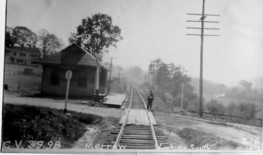
MERROW3 [CVT, 1912/13]
The 1913 CVT annual report tells us that "a new passenger and freight station was built at Merrow, Conn. some time between June 1912 and June 1913. The PUC photo on the right dates to 10/14/1927. [REFS: CVTAR14.1913.8][rev092317]
The 1913 CVT annual report tells us that "a new passenger and freight station was built at Merrow, Conn. some time between June 1912 and June 1913. The PUC photo on the right dates to 10/14/1927. [REFS: CVTAR14.1913.8][rev092317]

|

|
MERWINSVILLE1 [HRR, 1842; opened as GAYLORDS BRIDGE]
As seen on the 1854LC map, this stop in the town of NEW MILFORD was first called GAYLORD'S BRIDGE for the Galliard/Gaylord family settlers. Much has been made of local entrepreneur Sylvanus Merwin's buying of property east of the village center to capitalize on the coming of the railroad, by profiting from the land sale for the right of way, by building a trackside hotel with ticket office and waiting rooms, and by signing a railroad meal-stop contract that lasted until 1877. The renaming of the station as MERWINSVILLE probably had less to do with the railroad deal, as is generally thought, than with the appointment of the ambitious Merwin, already station master, as postmaster in place of John Gaylord. The post office was moved to the hotel and the name was changed from Gaylordsville to Merwinsville, with the HRR consequently renaming the stop. The gap in our timetables from 1852 to 1857 allows us to only first see this change in 1858. While the post office designation would be changed back with the reappointment of Gaylord in 1861, the station name would remain MERWINSVILLE for the next half century. [REFS: RF/02/15/1843/02; 1851TT; HDC/07/09/1853/02; PTH107.1858.15; Samuel Orcutt, History of the Towns of New Milford and Bridgewater, Connecticut, 1703-1882, p384+; C56; R55; NL9.7.7]
As seen on the 1854LC map, this stop in the town of NEW MILFORD was first called GAYLORD'S BRIDGE for the Galliard/Gaylord family settlers. Much has been made of local entrepreneur Sylvanus Merwin's buying of property east of the village center to capitalize on the coming of the railroad, by profiting from the land sale for the right of way, by building a trackside hotel with ticket office and waiting rooms, and by signing a railroad meal-stop contract that lasted until 1877. The renaming of the station as MERWINSVILLE probably had less to do with the railroad deal, as is generally thought, than with the appointment of the ambitious Merwin, already station master, as postmaster in place of John Gaylord. The post office was moved to the hotel and the name was changed from Gaylordsville to Merwinsville, with the HRR consequently renaming the stop. The gap in our timetables from 1852 to 1857 allows us to only first see this change in 1858. While the post office designation would be changed back with the reappointment of Gaylord in 1861, the station name would remain MERWINSVILLE for the next half century. [REFS: RF/02/15/1843/02; 1851TT; HDC/07/09/1853/02; PTH107.1858.15; Samuel Orcutt, History of the Towns of New Milford and Bridgewater, Connecticut, 1703-1882, p384+; C56; R55; NL9.7.7]

MERWINSVILLE2 [NYNH&H, 1905]
In 1905, a falling out with Merwin's son-in-law, Ed Hurd, who had taken over as station agent, caused the railroad to put a ticket office in the freight depot just south of the hotel and make that the new railroad station. The Merwinsville Hotel Restoration website [click here] says incorrectly that the converted freight depot was torn down in 1915. In fact, it was moved at that time to become LIME ROCK2, as shown in this photo, after the previous station there burned. We are keeping an eye peeled for a shot of this structure with a MERWINSVILLE signboard. [REFS: R54]
In 1905, a falling out with Merwin's son-in-law, Ed Hurd, who had taken over as station agent, caused the railroad to put a ticket office in the freight depot just south of the hotel and make that the new railroad station. The Merwinsville Hotel Restoration website [click here] says incorrectly that the converted freight depot was torn down in 1915. In fact, it was moved at that time to become LIME ROCK2, as shown in this photo, after the previous station there burned. We are keeping an eye peeled for a shot of this structure with a MERWINSVILLE signboard. [REFS: R54]
Max Miller Collection
|
|
|
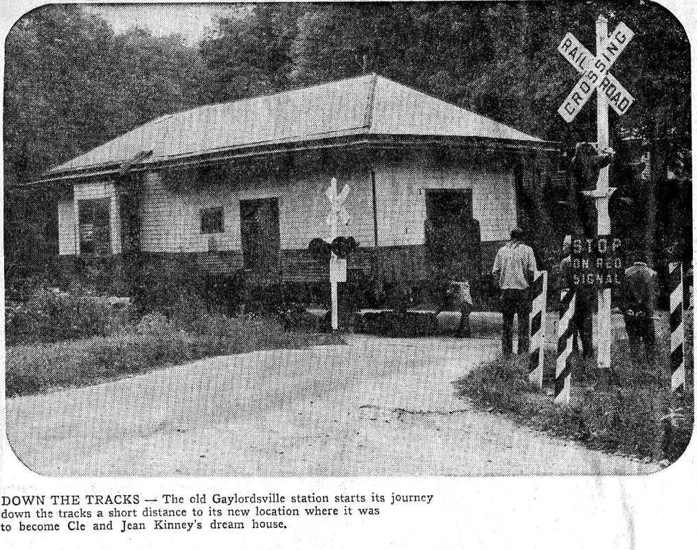
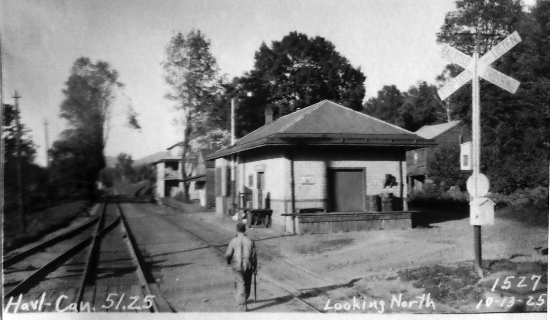
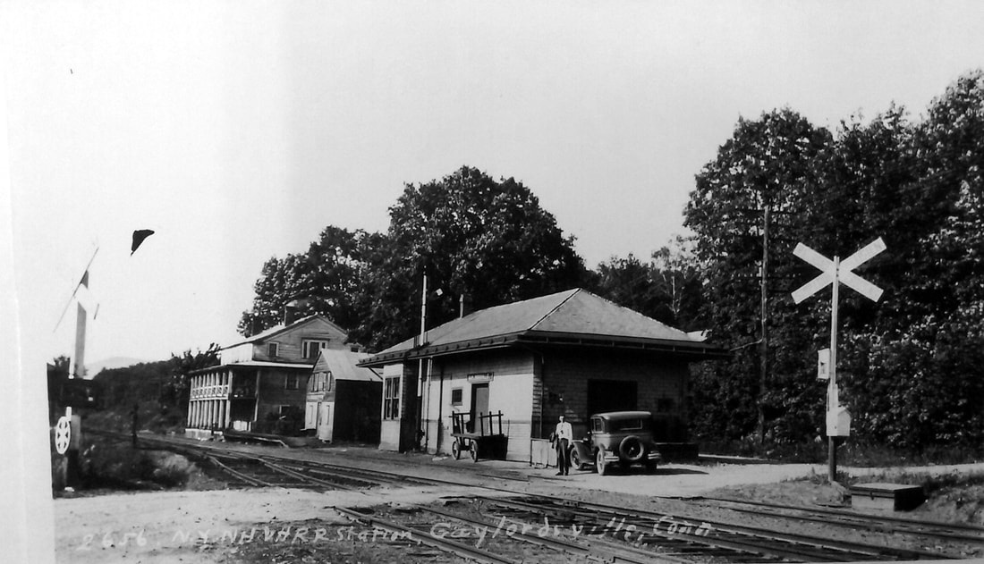
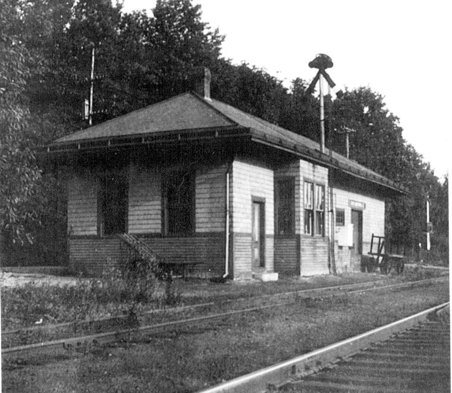
MERWINSVILLLE3 [NYNH&H, 1915]
A new combination station in 1915 replaced the converted freight depot that was moved to become LIME ROCK2. In spite of the bad feeling between Hurd and the railroad, the name of the stop was not changed back to GAYLORDSVILLE until 1918, reportedly on February 1. Timetables seem to bear this out. The PUC photo at [1] is dated 10/13/1925 and the shot at [2] is Lewis H. Benton's #2656 taken on 6/22/1930; Irving Drake is posing with the sedan that transported the pair on their photographic adventures. Order boards are down both ways in the undated, southward-looking shot at [3]. The image at [4] appeared in the newspaper when this station was purchased from the railroad in 1968 and moved in the fall of 1971, about 1,000 feet south and to the east side of the track, to be used as a private home. The saga is in the New York Times article that tells of the later acquisition of a caboose to complement the station. The tale of the depots built here and their successive renamings is unique enough historically, but even more remarkable for the fact that the hotel, the converted freight depot that became LIME ROCK2, and the final combination station all still stand today in 2019. [REFS: PTH925.1917.32; NHAR45.1916.10; NYT/01/02/1971/R1; NYT/11/10/1971/01?; D70; R54+][rev070315, 083019]
A new combination station in 1915 replaced the converted freight depot that was moved to become LIME ROCK2. In spite of the bad feeling between Hurd and the railroad, the name of the stop was not changed back to GAYLORDSVILLE until 1918, reportedly on February 1. Timetables seem to bear this out. The PUC photo at [1] is dated 10/13/1925 and the shot at [2] is Lewis H. Benton's #2656 taken on 6/22/1930; Irving Drake is posing with the sedan that transported the pair on their photographic adventures. Order boards are down both ways in the undated, southward-looking shot at [3]. The image at [4] appeared in the newspaper when this station was purchased from the railroad in 1968 and moved in the fall of 1971, about 1,000 feet south and to the east side of the track, to be used as a private home. The saga is in the New York Times article that tells of the later acquisition of a caboose to complement the station. The tale of the depots built here and their successive renamings is unique enough historically, but even more remarkable for the fact that the hotel, the converted freight depot that became LIME ROCK2, and the final combination station all still stand today in 2019. [REFS: PTH925.1917.32; NHAR45.1916.10; NYT/01/02/1971/R1; NYT/11/10/1971/01?; D70; R54+][rev070315, 083019]