Track 12: CT Passenger Stations, E
See TCS Home Page links for notes, abbreviations, and sources.
Use Track 11 map link to locate stations, rail and trolley lines, and POIs.
See TCS Home Page links for notes, abbreviations, and sources.
Use Track 11 map link to locate stations, rail and trolley lines, and POIs.

|

|

|
University of Vermont Spec. Colls.
|
|
|
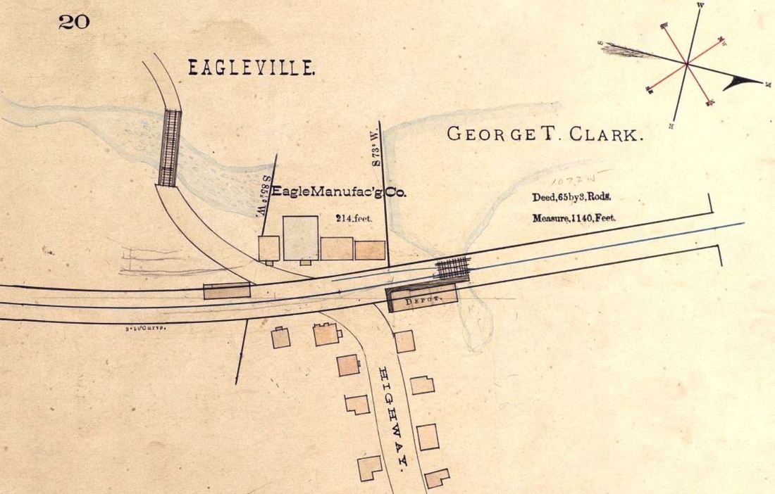
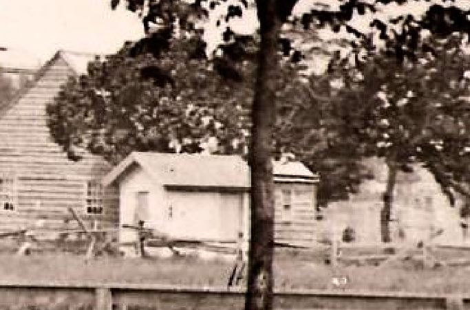
EAGLEVILLE1 [NLW&P, 1850]
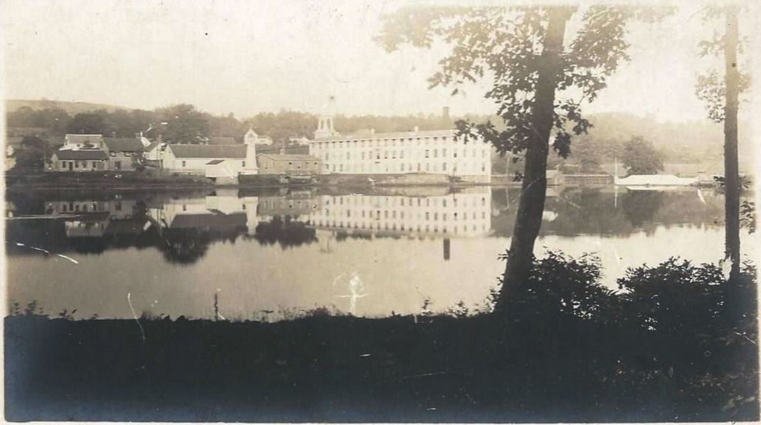
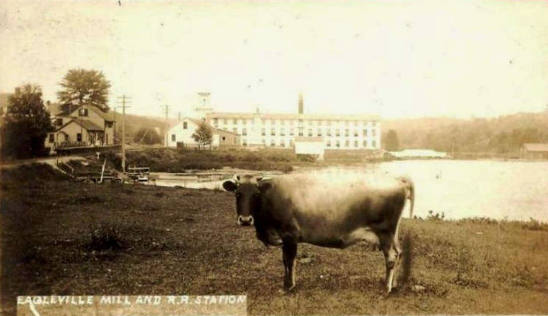
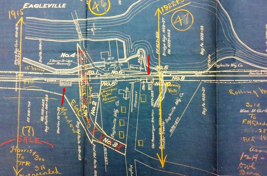
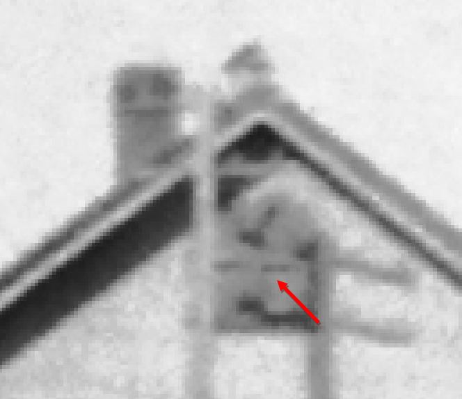
This stop was established in the town of Mansfield on 3/16/1850 when the NLW&P opened their line from WILLIMANTIC as far as STAFFORD SPRINGS; Palmer would be reached on 8/31/1850. The red arrow on the 1857TC map at [1] shows the location of the general store seen at [2] and the depot addition seen at [3] behind it. The ICC examiners said in their 8/1/1918 field notes that this was the only portion the railroad owned of the 'old' station, the new EAGLEVILLE2 already standing to the south. The 1883 NLN map at [4] shows the footprint and Eagleville Brook emptying into the Willimantic River just north of the station. It also shows the mill buildings of the Eagleville Company, a cotton-goods producer from 1822 to 1923 and the sole employer in this 'factory village.' The postcard at [5] looks east at the store and railroad station while its cousin at [6] frames a contented bovine in a southerly view of the mill complex. The fate of EAGLEVILLE1 is not known, though it was standing in 1918 when the ICC examiners visited. [REFS: NLWC/03/20/1850/03; NHER/11/16/1900/09; CRC48.1900.27][rev051417]
This stop was established in the town of Mansfield on 3/16/1850 when the NLW&P opened their line from WILLIMANTIC as far as STAFFORD SPRINGS; Palmer would be reached on 8/31/1850. The red arrow on the 1857TC map at [1] shows the location of the general store seen at [2] and the depot addition seen at [3] behind it. The ICC examiners said in their 8/1/1918 field notes that this was the only portion the railroad owned of the 'old' station, the new EAGLEVILLE2 already standing to the south. The 1883 NLN map at [4] shows the footprint and Eagleville Brook emptying into the Willimantic River just north of the station. It also shows the mill buildings of the Eagleville Company, a cotton-goods producer from 1822 to 1923 and the sole employer in this 'factory village.' The postcard at [5] looks east at the store and railroad station while its cousin at [6] frames a contented bovine in a southerly view of the mill complex. The fate of EAGLEVILLE1 is not known, though it was standing in 1918 when the ICC examiners visited. [REFS: NLWC/03/20/1850/03; NHER/11/16/1900/09; CRC48.1900.27][rev051417]
|
National Archives
|
|
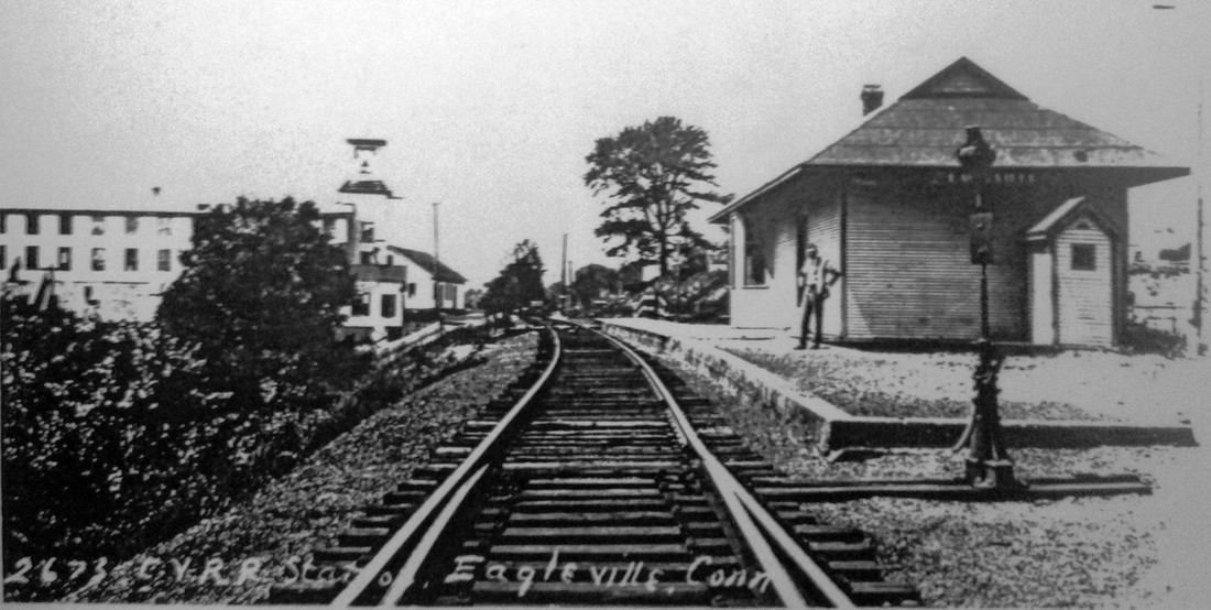
EAGLEVILLE2 [CVT, 1916]
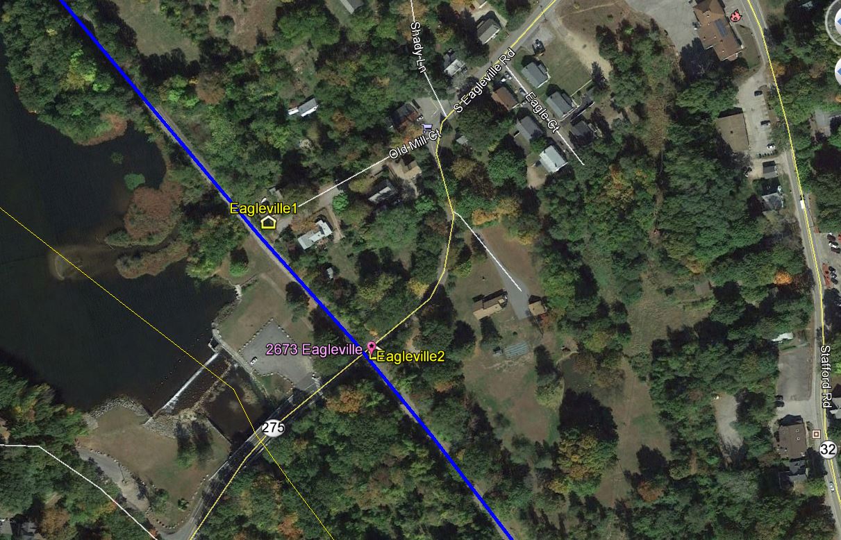
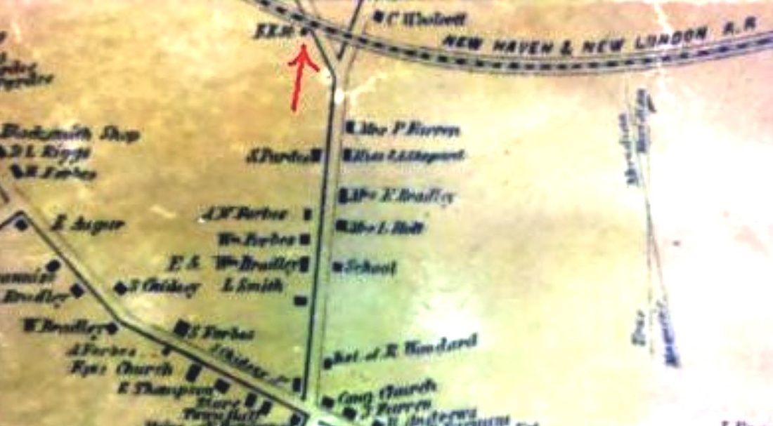
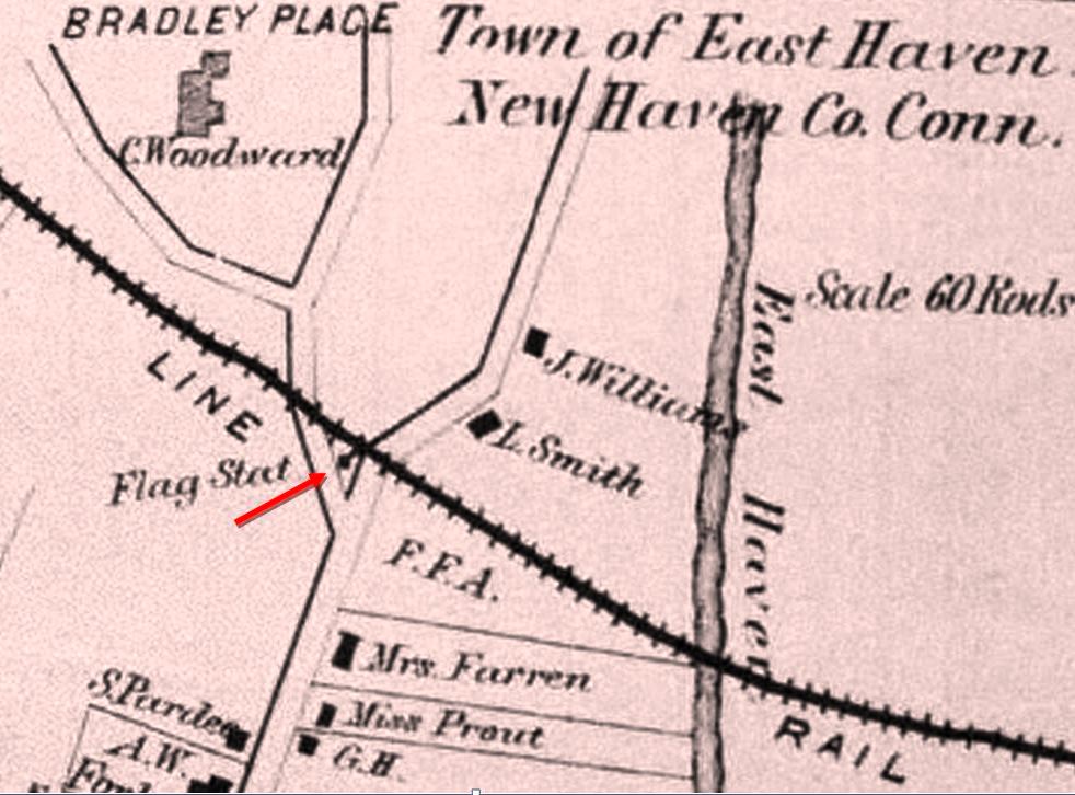
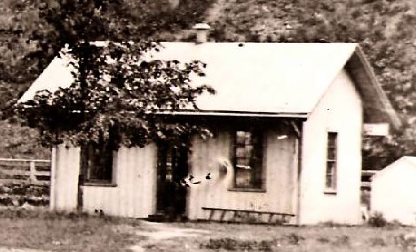
The June, 1916 CVT annual report says a grade crossing has been eliminated here and a new station put up. A Courant article says the PUC has approved the closing of the old station in favor of the new one 300 feet to the south. The shot at [1], the only we have ever seen of this station, was taken by Lewis H. Benton, his number 2673, on 6/23/1930, the dating based on our study of his work. Irving N. Drake, fellow photographer and traveling companion who provided the automobile used in their jaunts, poses on the platform of EAGLEVILLE2 in a northward-looking view. The real estate map based on the CVT valuation of 1917 at [2] shows the old station at our right arrow and the new one at the left arrow, both of which were standing when the ICC visited. The snippet at [3] from our Track 11 GE map shows the locations today. The fate of EAGLEVILLE2 is not known at this time. It is seen on the 1934 aerial map but gone by the one issued in 1965. [REFS: CVTAR17.1916.7; HC/02/08/1916/04][rev092317]
The June, 1916 CVT annual report says a grade crossing has been eliminated here and a new station put up. A Courant article says the PUC has approved the closing of the old station in favor of the new one 300 feet to the south. The shot at [1], the only we have ever seen of this station, was taken by Lewis H. Benton, his number 2673, on 6/23/1930, the dating based on our study of his work. Irving N. Drake, fellow photographer and traveling companion who provided the automobile used in their jaunts, poses on the platform of EAGLEVILLE2 in a northward-looking view. The real estate map based on the CVT valuation of 1917 at [2] shows the old station at our right arrow and the new one at the left arrow, both of which were standing when the ICC visited. The snippet at [3] from our Track 11 GE map shows the locations today. The fate of EAGLEVILLE2 is not known at this time. It is seen on the 1934 aerial map but gone by the one issued in 1965. [REFS: CVTAR17.1916.7; HC/02/08/1916/04][rev092317]
National Archives
|

|
Library of Congress
|

Library of Congress
|
|
|
EAST BERLIN1 [MRR, 1850]
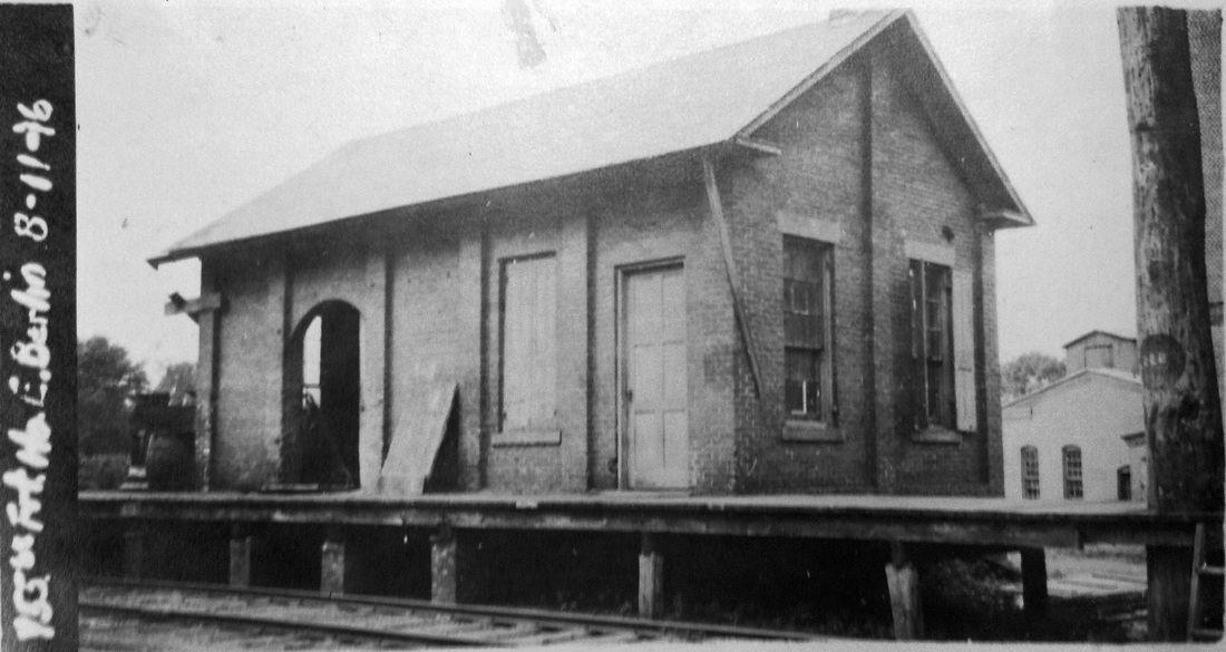
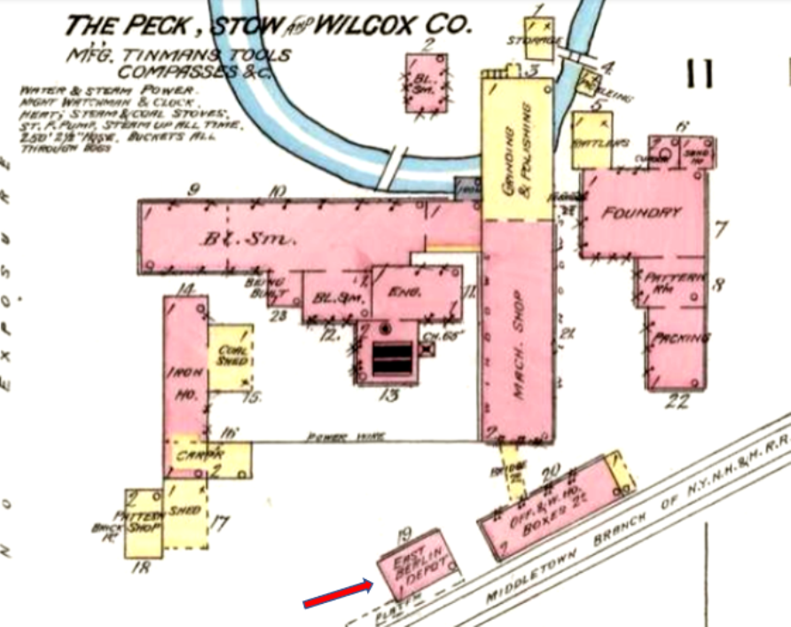
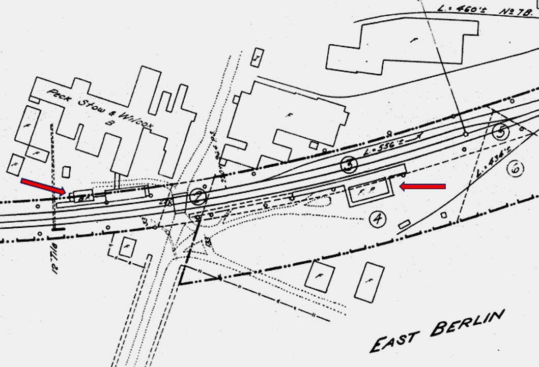
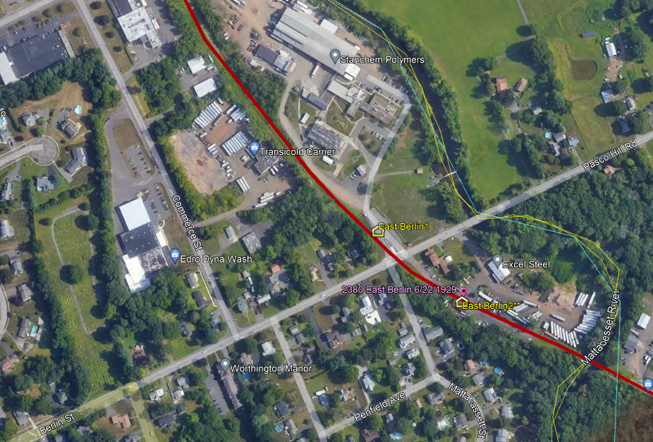
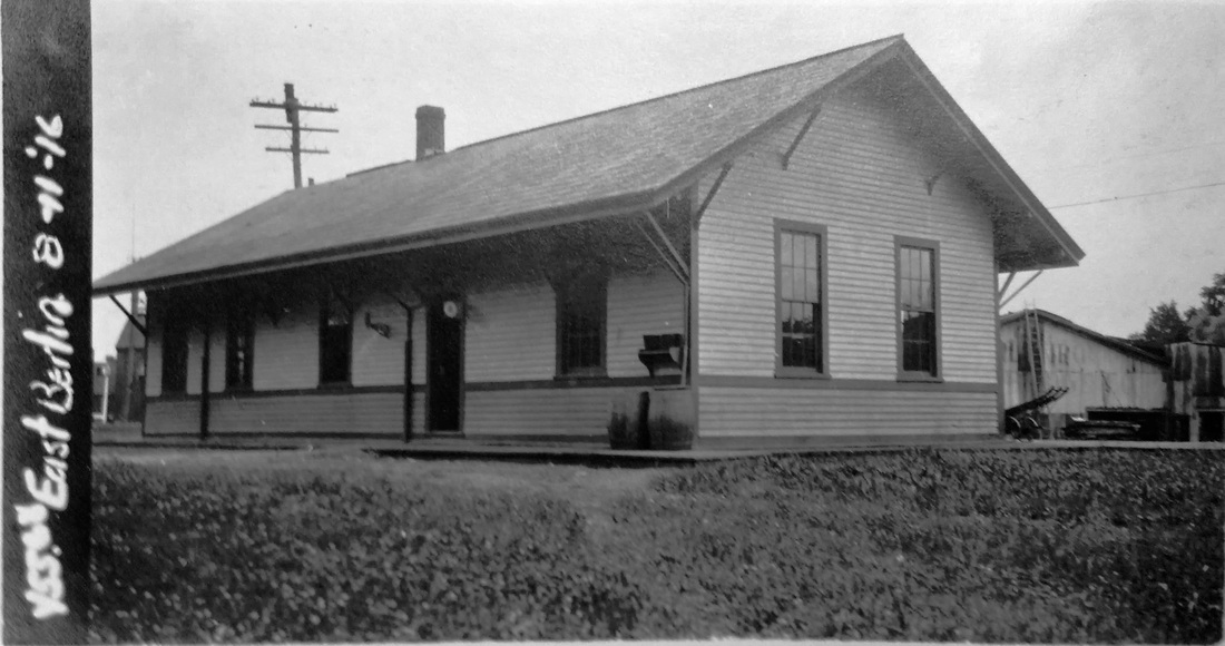
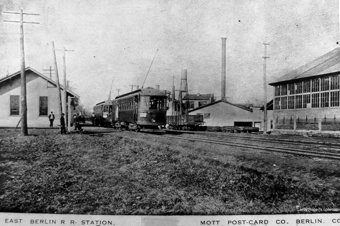
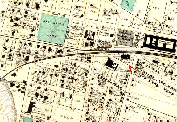
This stop was established in the town of BERLIN when the Middletown RR opened in 1850. The brick freight house shown in the 8/11/1916 ICC valuation photo at [1] was plausibly the first combination station. The rest of the story here is laid out in a series of maps. The 1869 map at [2] shows the location of the first station north of today's Berlin St. Since it is unclear exactly which building is indicated as the depot, we are choosing to think it was east of the track where our red arrow points, which agrees with where the November, 1887 Sanborn fire insurance map at [3] places the 'East Berlin Depot.' Pink indicates brick construction. Eight years later in 1895, the map at [4] labels this structure as the 'Freight Ho.' and the newer passenger station is seen below, again at our red arrows. Perhaps not well known is the fact that some of the earliest tinmakers in the United States were located in this area and their humble beginnings progressed into manufacturing the machinery which produced metal goods as well as the products themselves. The 1869 map shows predecessors of two of central Connecticut's best-known firms in existence at this early date. Roys & Wilcox dated back to 1785 and would evolve into Peck, Stow and Wilcox with a sizable plant adjacent to the first station above Berlin St., as seen on the 1887 map. PEXTO, as it it was known under its last tradename, went back to 1827 in SOUTHINGTON and once used the Farmington Canal for transporting raw materials and finished products. Through later mergers it also had a factory at PLANTSVILLE, both locations shipping via rail on the Canal line. Also already in existence in 1869 just to the south was the American Corrugated Iron Co. which would become the famed Berlin Iron Bridge Co. Both utilized the waterpower of the Mattabessett River which forms the border with Cromwell and both took advantage of the railroad for their transportation needs. The ICC valuation map at [5] shows the BF [Brick Freight] house at our upper red arrow and the FP [Frame, i.e. wooden, Passenger] station at our lower red arrow. The snippet from our Track 11 Google Earth map shows the area today with Stanchem and Excel Steel now taking the places of the former companies. [REFS: NLD/08/04/1849/01; RF/08/28/1849/03; SAM/09/01/1849/296; RF/11/06/1849/03; HC/12/10/1892/21; HC/08/24/1919/04X; HC/07/04/1930/17][rev013015, 030123]
This stop was established in the town of BERLIN when the Middletown RR opened in 1850. The brick freight house shown in the 8/11/1916 ICC valuation photo at [1] was plausibly the first combination station. The rest of the story here is laid out in a series of maps. The 1869 map at [2] shows the location of the first station north of today's Berlin St. Since it is unclear exactly which building is indicated as the depot, we are choosing to think it was east of the track where our red arrow points, which agrees with where the November, 1887 Sanborn fire insurance map at [3] places the 'East Berlin Depot.' Pink indicates brick construction. Eight years later in 1895, the map at [4] labels this structure as the 'Freight Ho.' and the newer passenger station is seen below, again at our red arrows. Perhaps not well known is the fact that some of the earliest tinmakers in the United States were located in this area and their humble beginnings progressed into manufacturing the machinery which produced metal goods as well as the products themselves. The 1869 map shows predecessors of two of central Connecticut's best-known firms in existence at this early date. Roys & Wilcox dated back to 1785 and would evolve into Peck, Stow and Wilcox with a sizable plant adjacent to the first station above Berlin St., as seen on the 1887 map. PEXTO, as it it was known under its last tradename, went back to 1827 in SOUTHINGTON and once used the Farmington Canal for transporting raw materials and finished products. Through later mergers it also had a factory at PLANTSVILLE, both locations shipping via rail on the Canal line. Also already in existence in 1869 just to the south was the American Corrugated Iron Co. which would become the famed Berlin Iron Bridge Co. Both utilized the waterpower of the Mattabessett River which forms the border with Cromwell and both took advantage of the railroad for their transportation needs. The ICC valuation map at [5] shows the BF [Brick Freight] house at our upper red arrow and the FP [Frame, i.e. wooden, Passenger] station at our lower red arrow. The snippet from our Track 11 Google Earth map shows the area today with Stanchem and Excel Steel now taking the places of the former companies. [REFS: NLD/08/04/1849/01; RF/08/28/1849/03; SAM/09/01/1849/296; RF/11/06/1849/03; HC/12/10/1892/21; HC/08/24/1919/04X; HC/07/04/1930/17][rev013015, 030123]

Connecticut Historical Society
|
|
|
|
|
|

Richard Erling photo
EAST BERLIN2 [NYNH&H, c1892]
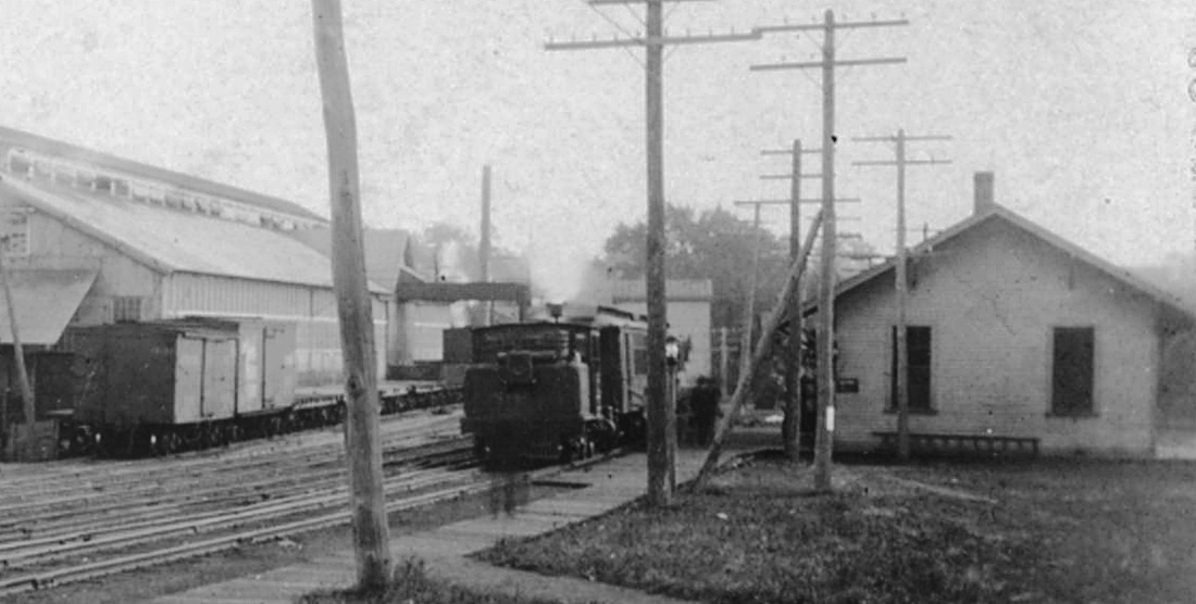
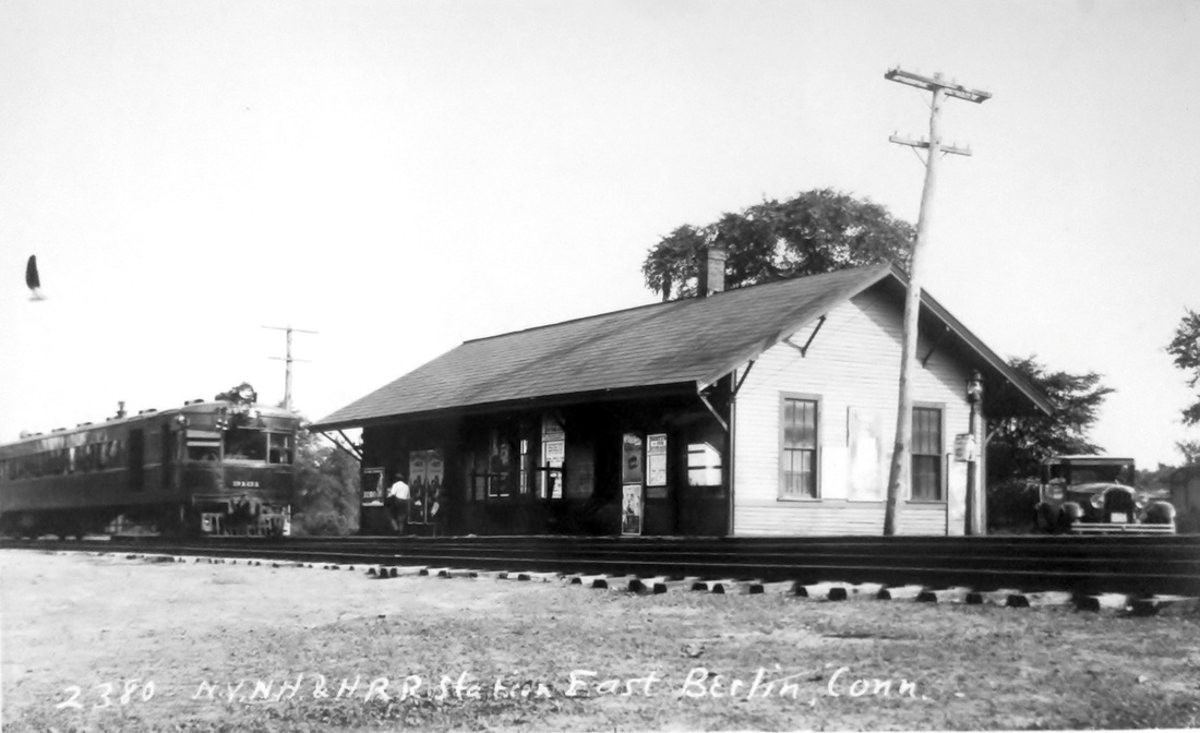
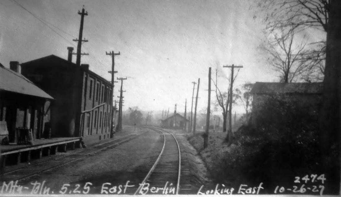
We have combed the annual reports and the newspapers but have come up short of the date that this later station opened. The only clue is an 1891 article saying that the news going around the state press was that a new station was to be built here. As seen after 1887 and before 1895 in the Sanborn maps above, an 1892 date seems plausible. The earliest image we have is the 1895 Berlin Iron Bridge Co. letterhead at [1]. It shows the new depot already built, perhaps in response to the burgeoning business that company was doing around the turn of the century. The company produced bridges, roofs and other prefabricated structural components for buildings, both of iron and steel. This made for a location shipping and receiving a lot of tonnage. One particularly large haul was in 1891 when a 23-car train weighing nearly 1,000,000 pounds left with materials for a boatworks in Rio de Janeiro. The ICC valuation photo at [2] is dated 8/11/1916; the new depot was on the west side of the track and below Berlin St. The next three shots show the unique progression of rail service on this line. The image at [3] has a dinky engine pulling two coaches, perhaps ca. 1906, after these locomotives replaced third-rail operations west of BERLIN. The shot at [4] shows two trolley cars under wire for electric service that was initiated on 7/8/1907 and lasted until 1927, the duties relegated thereafter to the gas-electric car seen at [5]. The latter was happily coincident with the peregrinations of Lewis H. Benton of Taunton, MA. His photo no. 2380 was taken in 1929, possibly on June 22, and shows fellow photographer Irving N. Drake's sedan at right. The 10/26/1927 PUC image at [6] looks compass-south at the passenger station. It is labeled east for the direction of the line from New Britain to Berlin. The corner of the brick freight depot is seen at the extreme left. The passenger station still stands in commercial use today. The shot at [7] dates to 12/21/2022. The 1938 SSRR list shows both the passenger and freight stations as rented, the latter for $50 per year. Service between NEWFIELD and EAST BERLIN ended in 1961 when the ICC approved the railroad's petition for discontinuance on the 4.13 miles of track because of lack of traffic. Thus ended 110 years of the railroad in this historic locale, a significant part of Connecticut's Hardware Belt. Many thanks to Richard Erling, long-time East Berlin resident, for his contributions to these updates. [REFS: HC/02/20/1873/02; WED/07/17/1891/05; HC/10/26/2892/06; HC/07/08/1907/16; SRJ/09/21/1907 /415; HC/05/27/1961/19C; SL15.1.6 (1984); R48][rev010318, 030123]
We have combed the annual reports and the newspapers but have come up short of the date that this later station opened. The only clue is an 1891 article saying that the news going around the state press was that a new station was to be built here. As seen after 1887 and before 1895 in the Sanborn maps above, an 1892 date seems plausible. The earliest image we have is the 1895 Berlin Iron Bridge Co. letterhead at [1]. It shows the new depot already built, perhaps in response to the burgeoning business that company was doing around the turn of the century. The company produced bridges, roofs and other prefabricated structural components for buildings, both of iron and steel. This made for a location shipping and receiving a lot of tonnage. One particularly large haul was in 1891 when a 23-car train weighing nearly 1,000,000 pounds left with materials for a boatworks in Rio de Janeiro. The ICC valuation photo at [2] is dated 8/11/1916; the new depot was on the west side of the track and below Berlin St. The next three shots show the unique progression of rail service on this line. The image at [3] has a dinky engine pulling two coaches, perhaps ca. 1906, after these locomotives replaced third-rail operations west of BERLIN. The shot at [4] shows two trolley cars under wire for electric service that was initiated on 7/8/1907 and lasted until 1927, the duties relegated thereafter to the gas-electric car seen at [5]. The latter was happily coincident with the peregrinations of Lewis H. Benton of Taunton, MA. His photo no. 2380 was taken in 1929, possibly on June 22, and shows fellow photographer Irving N. Drake's sedan at right. The 10/26/1927 PUC image at [6] looks compass-south at the passenger station. It is labeled east for the direction of the line from New Britain to Berlin. The corner of the brick freight depot is seen at the extreme left. The passenger station still stands in commercial use today. The shot at [7] dates to 12/21/2022. The 1938 SSRR list shows both the passenger and freight stations as rented, the latter for $50 per year. Service between NEWFIELD and EAST BERLIN ended in 1961 when the ICC approved the railroad's petition for discontinuance on the 4.13 miles of track because of lack of traffic. Thus ended 110 years of the railroad in this historic locale, a significant part of Connecticut's Hardware Belt. Many thanks to Richard Erling, long-time East Berlin resident, for his contributions to these updates. [REFS: HC/02/20/1873/02; WED/07/17/1891/05; HC/10/26/2892/06; HC/07/08/1907/16; SRJ/09/21/1907 /415; HC/05/27/1961/19C; SL15.1.6 (1984); R48][rev010318, 030123]
|

|
EAST BRIDGEPORT [NY&NH, 1868]
The railroad commissioners said in 1868 that a station had been established 1,800 feet east of the Pequonnock River drawbridge but we have never seen it on a timetable. The 1868 Beers map [left] shows it at Pembroke St. and Crescent Ave., about the correct distance from the river. By 1875, the bird's-eye map [right] shows only a triangular park here under the word 'Crescent.' While flag stops were often not on timetables, the size of the footprint on the 1868 map makes it look like a fairly substantial structure. The large factory complex to the north is the Wheeler and Wilson Manufacturing Co., which produced sewing machines and was one of Bridgeport's largest employers. Their band was a staple at festivals, patriotic celebrations, and special occasions like the gold and silver spike ceremony at Zoar Bridge in 1888 that heralded the opening of the Extension: see Track 6, MP 6.5.2 and elsewhere. The various factories here on this side of town were probably the reason for the original establishment of an EAST BRIDGEPORT stop, whatever its fate might have been. [REFS: RRC5.301 (3/2/1868)]
The railroad commissioners said in 1868 that a station had been established 1,800 feet east of the Pequonnock River drawbridge but we have never seen it on a timetable. The 1868 Beers map [left] shows it at Pembroke St. and Crescent Ave., about the correct distance from the river. By 1875, the bird's-eye map [right] shows only a triangular park here under the word 'Crescent.' While flag stops were often not on timetables, the size of the footprint on the 1868 map makes it look like a fairly substantial structure. The large factory complex to the north is the Wheeler and Wilson Manufacturing Co., which produced sewing machines and was one of Bridgeport's largest employers. Their band was a staple at festivals, patriotic celebrations, and special occasions like the gold and silver spike ceremony at Zoar Bridge in 1888 that heralded the opening of the Extension: see Track 6, MP 6.5.2 and elsewhere. The various factories here on this side of town were probably the reason for the original establishment of an EAST BRIDGEPORT stop, whatever its fate might have been. [REFS: RRC5.301 (3/2/1868)]

|
|
|
|
|
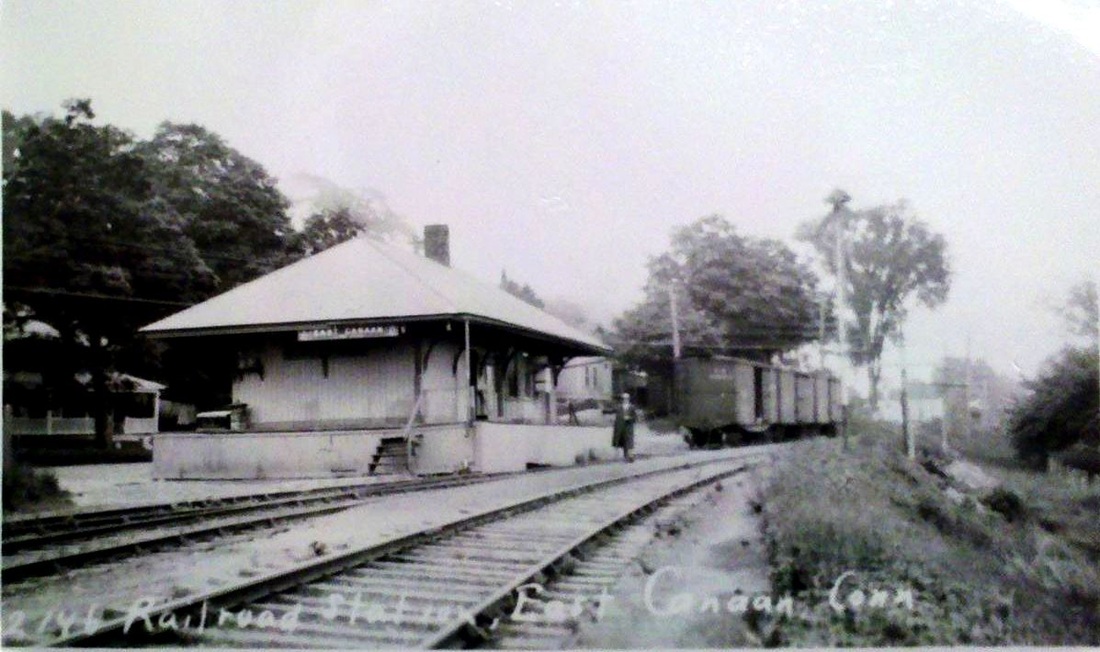
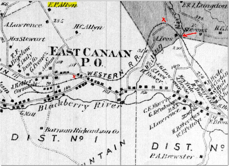
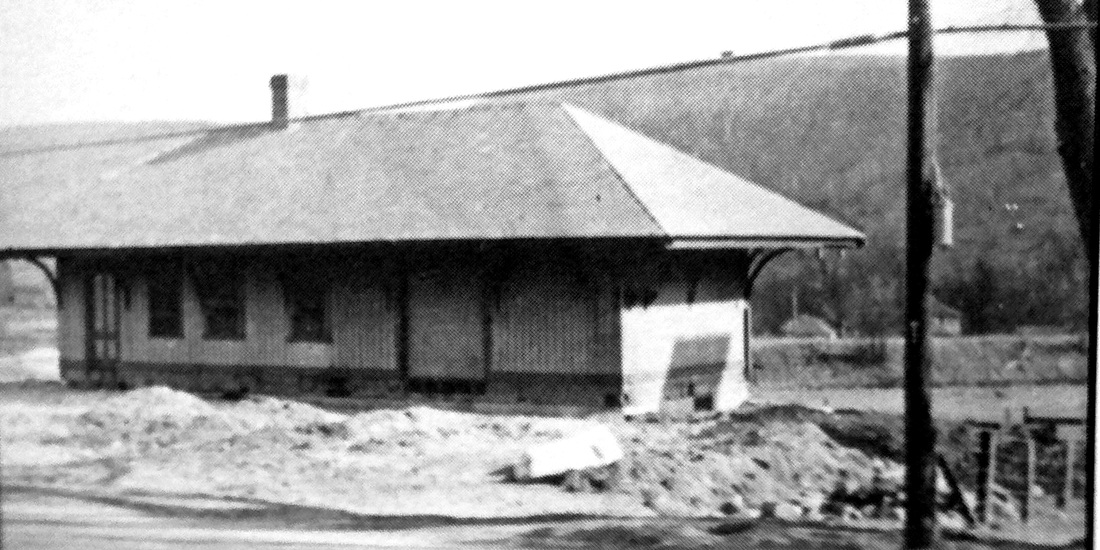
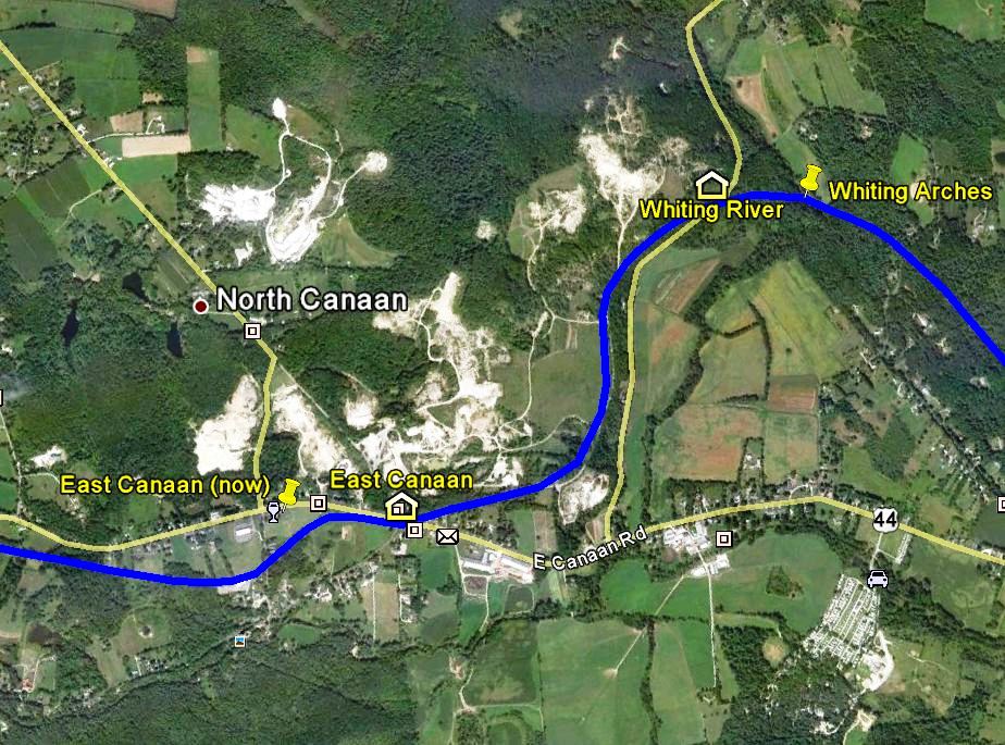
EAST CANAAN [CW, 1873]
This stop in the town of North Canaan debuted with the CW in 1871. The image at upper left looks to be from the 1920s with some activity at the station and the one in the middle, a Benton and Drake, is reportedly from 1928. The image at lower right is from our CTTRAXMAP and we have put red arrows on the 1874 map above it to highlight the corresponding points of interest. An opening-day article in the Courant lists this station as a flag stop. According to both Roy and Nimke, this structure was built in 1873 and the Connecticut Western News corroborates that by saying in October, 1872 "the depot for the East Canaan station is being raised this week." It is interesting to see the word 'station' being used in its technical sense as the place where the train stops and the word 'depot' used for the actual structure. The coming of the depot was not awaited patiently here, with the locals said humorously to be considering at one point to move their village to the line of the HRR, which was said to provide good station facilities for their towns! The News wrote in May, 1872 that "the good people plead in the tearful eloquence of injured innocence, for a depot. If nothing better can be afforded for a station that sells so many passenger tickets, won't the company coax a friendly barn up by the side of the track, to be used for depot? If occasionally an old brown clapboard flaps about to the tune of Old Boreas, not a word of complaint will be lisped from the lips of an East Canaanite." Finally completed in January, 1873, what the community got may not have been all that first-class. We recently found a important document in the Turner Collection at the Connecticut Historical Society wherein the NY&NE, who apparently was thinking of leasing the CW, did an appraisal of all the structures along the line. EAST CANAAN was said to be in fair condition, needing $125 in repairs, and worth $600 at the time. Interestingly, LAKEVILLE1 and NORFOLK1 were valued at $1500 and $1700 respectively, leading us to wonder if the station pictured here was the second rather than the first and built after 1880. The depot location was in the southwest quadrant of the diagonal grade crossing at Albany Tpke, today's U.S. Rte. 44. This stop would be a lucrative one for the railroad over the years, with the nearby Barnum Richardson operations plus the marble quarries to the northeast on the Erastus P. Allyn farm. The whitened excavations, evident today on the CTTRAXMAP snippet, are the quarry sites where special diamond and spindle drills were once used to cut stone blocks to be finished at the steam-powered saw mill. Some of the fine quality stone would be used for the building of the present state capitol. Recognizing the local association, the CNE would choose ALLYNDALE in 1916 as the final station name here for more clarity in train orders. The depot would be moved a half mile west in April, 1938 where it still serves as a residence today in 2012. The move is seen in progress at lower left. [REFS: HDC/12/21/1871/02; CWN/02/23/1872/02; CWN/03/08/1872/02; CWN/04/19/1872/02; CWN/05/24/1872/02; CWN/10/18/1872/02; CWN/11/01/1872/02; CWN/01/03/1873/02; CWN/10/31/1873/02; HDC/05/30/1874/02; CWN/11/13/1874/02; CW/NYNE1880; D37; N3.63; R49][rev100312]
This stop in the town of North Canaan debuted with the CW in 1871. The image at upper left looks to be from the 1920s with some activity at the station and the one in the middle, a Benton and Drake, is reportedly from 1928. The image at lower right is from our CTTRAXMAP and we have put red arrows on the 1874 map above it to highlight the corresponding points of interest. An opening-day article in the Courant lists this station as a flag stop. According to both Roy and Nimke, this structure was built in 1873 and the Connecticut Western News corroborates that by saying in October, 1872 "the depot for the East Canaan station is being raised this week." It is interesting to see the word 'station' being used in its technical sense as the place where the train stops and the word 'depot' used for the actual structure. The coming of the depot was not awaited patiently here, with the locals said humorously to be considering at one point to move their village to the line of the HRR, which was said to provide good station facilities for their towns! The News wrote in May, 1872 that "the good people plead in the tearful eloquence of injured innocence, for a depot. If nothing better can be afforded for a station that sells so many passenger tickets, won't the company coax a friendly barn up by the side of the track, to be used for depot? If occasionally an old brown clapboard flaps about to the tune of Old Boreas, not a word of complaint will be lisped from the lips of an East Canaanite." Finally completed in January, 1873, what the community got may not have been all that first-class. We recently found a important document in the Turner Collection at the Connecticut Historical Society wherein the NY&NE, who apparently was thinking of leasing the CW, did an appraisal of all the structures along the line. EAST CANAAN was said to be in fair condition, needing $125 in repairs, and worth $600 at the time. Interestingly, LAKEVILLE1 and NORFOLK1 were valued at $1500 and $1700 respectively, leading us to wonder if the station pictured here was the second rather than the first and built after 1880. The depot location was in the southwest quadrant of the diagonal grade crossing at Albany Tpke, today's U.S. Rte. 44. This stop would be a lucrative one for the railroad over the years, with the nearby Barnum Richardson operations plus the marble quarries to the northeast on the Erastus P. Allyn farm. The whitened excavations, evident today on the CTTRAXMAP snippet, are the quarry sites where special diamond and spindle drills were once used to cut stone blocks to be finished at the steam-powered saw mill. Some of the fine quality stone would be used for the building of the present state capitol. Recognizing the local association, the CNE would choose ALLYNDALE in 1916 as the final station name here for more clarity in train orders. The depot would be moved a half mile west in April, 1938 where it still serves as a residence today in 2012. The move is seen in progress at lower left. [REFS: HDC/12/21/1871/02; CWN/02/23/1872/02; CWN/03/08/1872/02; CWN/04/19/1872/02; CWN/05/24/1872/02; CWN/10/18/1872/02; CWN/11/01/1872/02; CWN/01/03/1873/02; CWN/10/31/1873/02; HDC/05/30/1874/02; CWN/11/13/1874/02; CW/NYNE1880; D37; N3.63; R49][rev100312]
Max Miller Collection
|

|
EAST DANBURY [HRR, 1887]
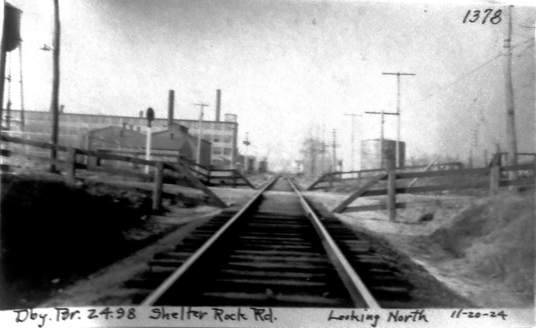
A newspaper article late in 1887 said that all HRR D&N division trains, except New York expresses, would begin stopping on flag signal at this station "at the crossing just south of Green's new hat shop" as of October 3. Tickets were to be sold from both Danbury and Bethel at five cents each, ten cents if purchased on the train. The John W. Green factory on Shelter Rock Rd. burned on 12/7/1898 and was rebuilt, as seen in the photograph. We do not know if there was any depot structure here initially but there was only a platform in later days. This location is reportedly synonymous with Cannon's Crossing, as identified in old photographs. The different captioning at the bottom seems to suggest that the PUC itself made more than one copy of this official inspection photograph of 11/20/1924. [REFS: DEN/10/01/1887/03]
A newspaper article late in 1887 said that all HRR D&N division trains, except New York expresses, would begin stopping on flag signal at this station "at the crossing just south of Green's new hat shop" as of October 3. Tickets were to be sold from both Danbury and Bethel at five cents each, ten cents if purchased on the train. The John W. Green factory on Shelter Rock Rd. burned on 12/7/1898 and was rebuilt, as seen in the photograph. We do not know if there was any depot structure here initially but there was only a platform in later days. This location is reportedly synonymous with Cannon's Crossing, as identified in old photographs. The different captioning at the bottom seems to suggest that the PUC itself made more than one copy of this official inspection photograph of 11/20/1924. [REFS: DEN/10/01/1887/03]
EAST DERBY [> DERBY1]
Dave Peters Collection
|
|
|
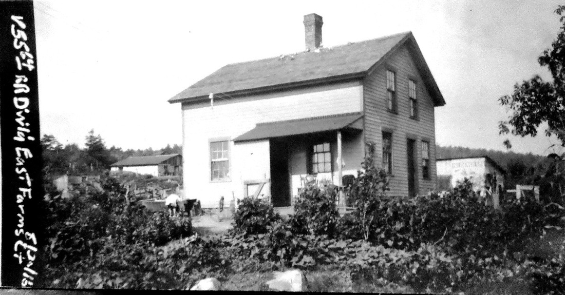
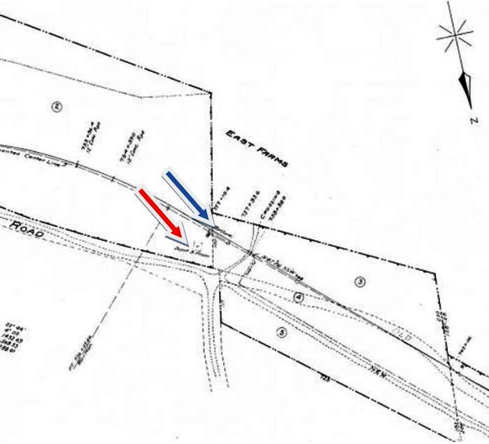
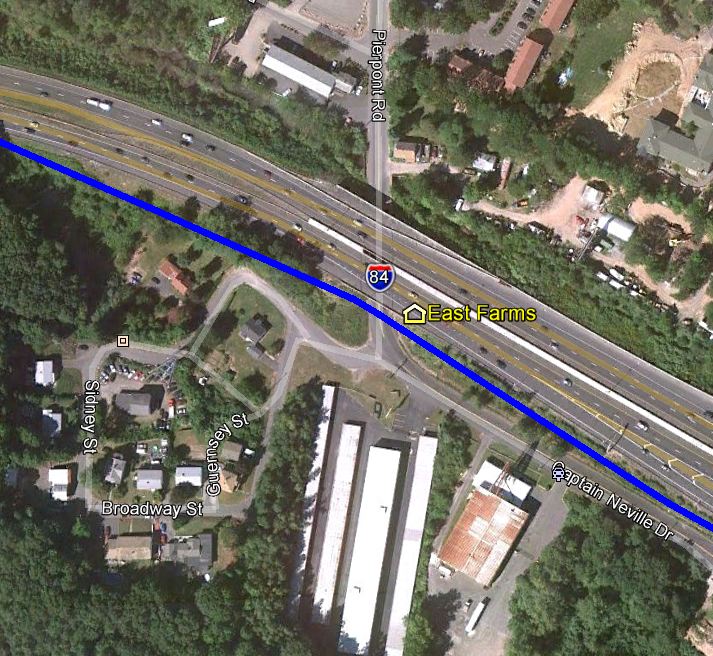
EAST FARMS [M&W, 1888]
This stop on Waterbury's east side was established by the M&W when it linked its namesake municipalities of Meriden and Waterbury in 1888. The val photo at upper left is dated 8/30/1916 and the 1915 val map at middle shows the arrangement of the grounds at that time. Situated on the north side of the track was a platform as well as a home just up the hill that was bought by the railroad and used as a depot. It is interesting that the railroad went to the trouble and expense of doing this here when most all the other stations along this line were small but substantial enclosed shelters like EAST SUMMIT and SOUTHINGTON ROAD. The real estate card at lower left indicates that the station and the property was sold prior to the 1925 abandonment of the line from here to West Main St., Meriden. Passenger service had already ended in 1917. As best we can figure, this location is the intersection of Pierpont Rd. and Captain Neville Drive today, with the actual station site as well as the ROW in this area obliterated by I-84. This is seen at upper right on the snippet from our CTTRAXMAP. The east-west highway north of the station on the val map is the old Plank Road built between Cheshire and Waterbury in 1852 [click here]. The Cheshire Street Rwy interurban trolley line that opened in 1905 would parallel the M&W and both lines would criss-cross this historic artery several times from The Notch at WEST CHESHIRE all the way to the Brass City. Many segments of Plank Road, still so-named, are in use today. [rev031213]
This stop on Waterbury's east side was established by the M&W when it linked its namesake municipalities of Meriden and Waterbury in 1888. The val photo at upper left is dated 8/30/1916 and the 1915 val map at middle shows the arrangement of the grounds at that time. Situated on the north side of the track was a platform as well as a home just up the hill that was bought by the railroad and used as a depot. It is interesting that the railroad went to the trouble and expense of doing this here when most all the other stations along this line were small but substantial enclosed shelters like EAST SUMMIT and SOUTHINGTON ROAD. The real estate card at lower left indicates that the station and the property was sold prior to the 1925 abandonment of the line from here to West Main St., Meriden. Passenger service had already ended in 1917. As best we can figure, this location is the intersection of Pierpont Rd. and Captain Neville Drive today, with the actual station site as well as the ROW in this area obliterated by I-84. This is seen at upper right on the snippet from our CTTRAXMAP. The east-west highway north of the station on the val map is the old Plank Road built between Cheshire and Waterbury in 1852 [click here]. The Cheshire Street Rwy interurban trolley line that opened in 1905 would parallel the M&W and both lines would criss-cross this historic artery several times from The Notch at WEST CHESHIRE all the way to the Brass City. Many segments of Plank Road, still so-named, are in use today. [rev031213]
|
|
|
National Archives
|
National Archives
|
|
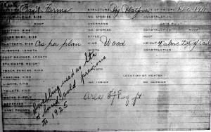
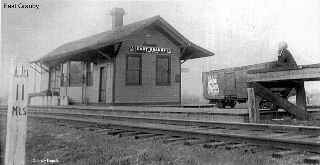
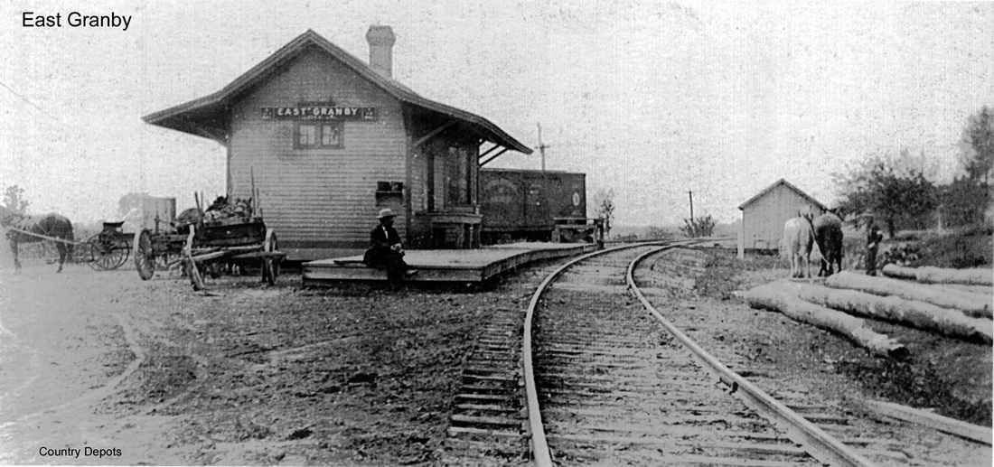
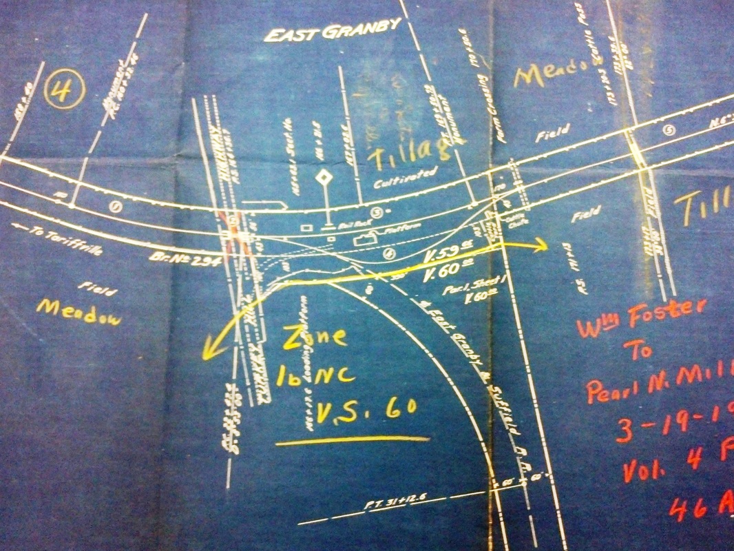
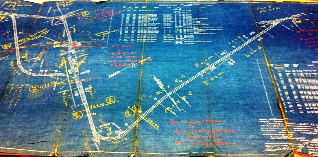
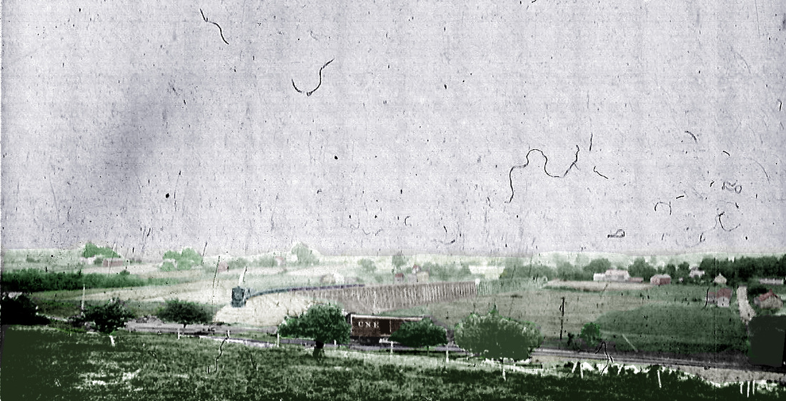
EAST GRANBY [CNE, 1903]
Service to this station was established on 12/16/1901, the Courant of the next day reporting that "the Central New England road began yesterday to run trains on the Springfield branch between Tariffville and East Granby. A mixed train is used and returns at night. A regular agent is in charge of the East Granby station and agents will receive freight and sell tickets to and from East Granby. The branch is now completed as far as the famous Montague farm. About 100 men are at work near East Granby and it is quite a railroad center at present. The work on the loop to connect with the Springfield end of the branch has been in progress a few weeks. It will require about three months to finish the loop and make the connections. It is believed that trains will be running to Springfield when it is warm weather." Nimke's textbox incorrectly gives 1905 as the build date for this station. The railroad commissioners put it in their annual report for 1903 and newspaper articles in June of that year echo each other in saying that "the Central New England railroad have laid the foundation(s) for a new depot building in East Granby at the junction of the Springfield line with the proposed branch to Windsor Locks." R&LHS notes show construction expenses began in April and ended in October, 1903. Note the milepost for Agawam Jct in the view at [1]. The image at [2] looks south with a box car on the runaround track, off of which the EG&S loop commenced. The RAM map at [3] shows the 3.5-mile loop around the Montague farm and the Windsor Locks RR. This latter railroad, surveyed but never built, had arisen from the farm controversy as part of a wider loop that would increase CNE traffic by draining it from the NYNH&H at Windsor Locks. The map also shows the line through the Montague property, which was completed in early 1903 after the 313-ft-wide strip suddenly became available for a pittance. The first train ran via the farm on 3/9/1903, thus making the loop redundant trackage. The val map snippet [4] shows the footprint of EAST GRANBY2 which is seen on the full map [5] at the junction point at top right. The junction at top left was where the loop originally was to have cut off the main line. The valuable panorama at [6] appeared in "The Battle for Springfield" article. The roof edge of EAST GRANBY2 is seen at the far lower left. Trestle work for the EG&S loop is in the center of the photo, with final work in progress probably late in 1902. A photo in Nimke shows this depot still standing in 1936 and the 1938 SSRR list says it was sold on 5/24/1938 to E.L. Gill(?). Railroad real estate records indicate that it was removed on 10/1/1938 per Authority For Expenditure (AFE) 31793. Track was taken up in the same year. The epic Battle for Springfield was a classic David and Goliath story. This saga of obstructionist greed and political shenanigan, which would ultimately see Edwin D. Robbins, NYNH&H corporate counsel, in the field tearing up track with Consolidated hirelings, dominated local news media from 1899 to 1904 and, in the end, the almighty NYNH&H got control of the CNE on 2/10/1904. By 5/10/1904 the newspapers reported that the loop, which had seen some freight use from 1903 to 1904, was stripped of rails and ties. Passenger service otherwise ended on this branch in 1922. [REFS: SR/11/24/1899/03; HC/11/01/1901/04; HC/12/17/1901/03; HC/12/16/1902/03: Short Line RR; CRC51.1903.22; BH/02/19/1903/05; HC/03/07/1903/20; HC/03/10/1903/04; SR/06/23/1903/10; WEC/06/23/1903/08; HC/11/14/1903/05; SR/02/06/1904/14; BH/02/11/1904/08; HC/02/11/1904/06; HC/05/10/1904/18; SR/05/10/1904/06; B559; Adams, NMRA Bulletin 454 (44.3, 11/1978); D52; E253; K115; N3.15][rev071416, 072819]
Service to this station was established on 12/16/1901, the Courant of the next day reporting that "the Central New England road began yesterday to run trains on the Springfield branch between Tariffville and East Granby. A mixed train is used and returns at night. A regular agent is in charge of the East Granby station and agents will receive freight and sell tickets to and from East Granby. The branch is now completed as far as the famous Montague farm. About 100 men are at work near East Granby and it is quite a railroad center at present. The work on the loop to connect with the Springfield end of the branch has been in progress a few weeks. It will require about three months to finish the loop and make the connections. It is believed that trains will be running to Springfield when it is warm weather." Nimke's textbox incorrectly gives 1905 as the build date for this station. The railroad commissioners put it in their annual report for 1903 and newspaper articles in June of that year echo each other in saying that "the Central New England railroad have laid the foundation(s) for a new depot building in East Granby at the junction of the Springfield line with the proposed branch to Windsor Locks." R&LHS notes show construction expenses began in April and ended in October, 1903. Note the milepost for Agawam Jct in the view at [1]. The image at [2] looks south with a box car on the runaround track, off of which the EG&S loop commenced. The RAM map at [3] shows the 3.5-mile loop around the Montague farm and the Windsor Locks RR. This latter railroad, surveyed but never built, had arisen from the farm controversy as part of a wider loop that would increase CNE traffic by draining it from the NYNH&H at Windsor Locks. The map also shows the line through the Montague property, which was completed in early 1903 after the 313-ft-wide strip suddenly became available for a pittance. The first train ran via the farm on 3/9/1903, thus making the loop redundant trackage. The val map snippet [4] shows the footprint of EAST GRANBY2 which is seen on the full map [5] at the junction point at top right. The junction at top left was where the loop originally was to have cut off the main line. The valuable panorama at [6] appeared in "The Battle for Springfield" article. The roof edge of EAST GRANBY2 is seen at the far lower left. Trestle work for the EG&S loop is in the center of the photo, with final work in progress probably late in 1902. A photo in Nimke shows this depot still standing in 1936 and the 1938 SSRR list says it was sold on 5/24/1938 to E.L. Gill(?). Railroad real estate records indicate that it was removed on 10/1/1938 per Authority For Expenditure (AFE) 31793. Track was taken up in the same year. The epic Battle for Springfield was a classic David and Goliath story. This saga of obstructionist greed and political shenanigan, which would ultimately see Edwin D. Robbins, NYNH&H corporate counsel, in the field tearing up track with Consolidated hirelings, dominated local news media from 1899 to 1904 and, in the end, the almighty NYNH&H got control of the CNE on 2/10/1904. By 5/10/1904 the newspapers reported that the loop, which had seen some freight use from 1903 to 1904, was stripped of rails and ties. Passenger service otherwise ended on this branch in 1922. [REFS: SR/11/24/1899/03; HC/11/01/1901/04; HC/12/17/1901/03; HC/12/16/1902/03: Short Line RR; CRC51.1903.22; BH/02/19/1903/05; HC/03/07/1903/20; HC/03/10/1903/04; SR/06/23/1903/10; WEC/06/23/1903/08; HC/11/14/1903/05; SR/02/06/1904/14; BH/02/11/1904/08; HC/02/11/1904/06; HC/05/10/1904/18; SR/05/10/1904/06; B559; Adams, NMRA Bulletin 454 (44.3, 11/1978); D52; E253; K115; N3.15][rev071416, 072819]
|
|
|

|
|
|
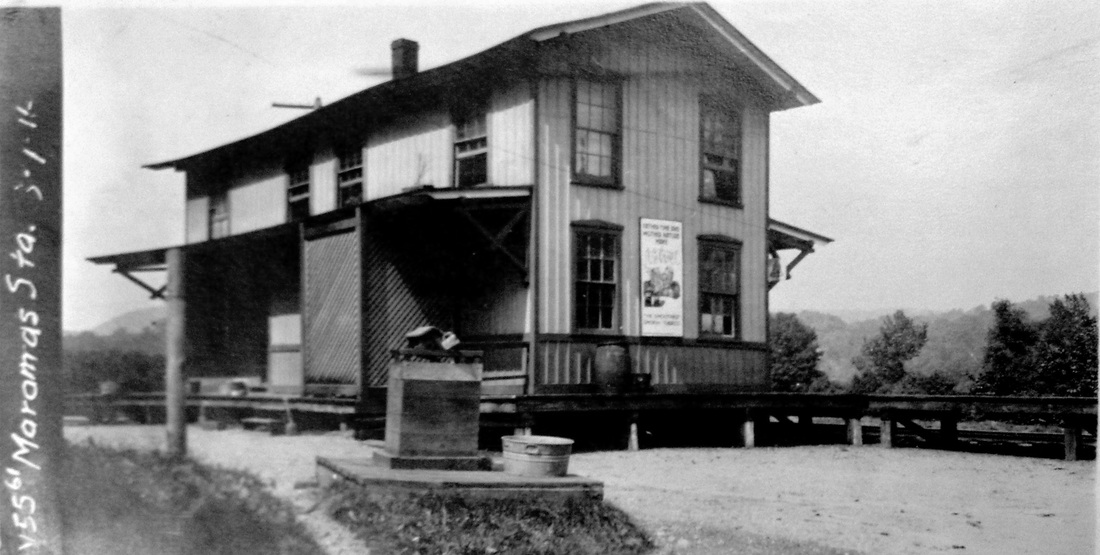
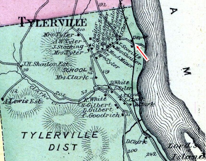
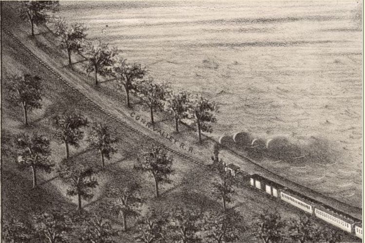
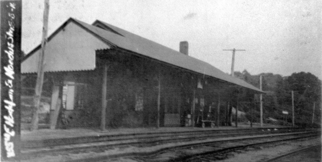
EAST HADDAM1 [CV, 1871; depot 1872?]
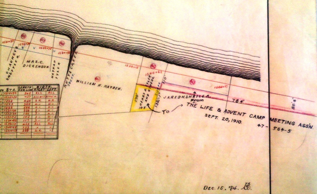
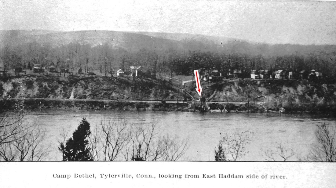
This station, actually on the west side of the Connecticut River in the town of Haddam, was known over the years by a number of names, including GOODSPEEDS AND MOODUS, EAST HADDAM, and EAST HADDAM AND MOODUS. The latter communities were east of the river but this was their closest rail access point. According to the newspaper, this station was up for opening day but other reports say tickets were first sold at a house across the street. The first depot was a two-story structure like MAROMAS, which we have borrowed to show here. EAST HADDAM1 burned in 1897 in a fire that started when burglars used explosives to blow open the safe. The 1874 Beers map at middle shows the location in the section of Haddam known as Tylerville, which got its first notice in the Courant in 1872 when a post office was established, Horace J. Cook postmaster. The locale was perhaps best known as Goodspeeds for the landing where the ferry from the east shore docked until the present swing bridge was built in 1913. The snippet from the 1880 Bailey bird's-eye map [click here] at upper right unfortunately does not include the depot from which the train has just departed but does show the shore across from the railroad station. This stop realized a considerable amount of business in August of each year when the Camp Bethel revival meetings were held just north of the depot. The photo at lower left shows attendees lunching between services which began officially in 1878 [click here], though the railroad real estate atlas at lower middle shows property ownership here for the Life & Advent Camp Meeting Assn. dating back to 1874. A later Courant article said that the 1899 meeting would be the 22nd at Tylerville and that excursion rates were being offered by the railroad. The group became the nondenominational Camp Bethel Association in 1965 [click here] and is still in existence today on the appropriately named Camp Bethel Rd. The postcard at lower right looks at the camp from the East Haddam side of the river and our red arrow points to the camp's water-pump house that stood down by the CV track. [REFS: HDC/08/25/1871/02; HDC/01/25/1872/04; HDC/09/22/1875 /04; HDC/08/06/1878/02; NHER/02/05/1897/02; HC/07/27/1899/07][rev070215]
This station, actually on the west side of the Connecticut River in the town of Haddam, was known over the years by a number of names, including GOODSPEEDS AND MOODUS, EAST HADDAM, and EAST HADDAM AND MOODUS. The latter communities were east of the river but this was their closest rail access point. According to the newspaper, this station was up for opening day but other reports say tickets were first sold at a house across the street. The first depot was a two-story structure like MAROMAS, which we have borrowed to show here. EAST HADDAM1 burned in 1897 in a fire that started when burglars used explosives to blow open the safe. The 1874 Beers map at middle shows the location in the section of Haddam known as Tylerville, which got its first notice in the Courant in 1872 when a post office was established, Horace J. Cook postmaster. The locale was perhaps best known as Goodspeeds for the landing where the ferry from the east shore docked until the present swing bridge was built in 1913. The snippet from the 1880 Bailey bird's-eye map [click here] at upper right unfortunately does not include the depot from which the train has just departed but does show the shore across from the railroad station. This stop realized a considerable amount of business in August of each year when the Camp Bethel revival meetings were held just north of the depot. The photo at lower left shows attendees lunching between services which began officially in 1878 [click here], though the railroad real estate atlas at lower middle shows property ownership here for the Life & Advent Camp Meeting Assn. dating back to 1874. A later Courant article said that the 1899 meeting would be the 22nd at Tylerville and that excursion rates were being offered by the railroad. The group became the nondenominational Camp Bethel Association in 1965 [click here] and is still in existence today on the appropriately named Camp Bethel Rd. The postcard at lower right looks at the camp from the East Haddam side of the river and our red arrow points to the camp's water-pump house that stood down by the CV track. [REFS: HDC/08/25/1871/02; HDC/01/25/1872/04; HDC/09/22/1875 /04; HDC/08/06/1878/02; NHER/02/05/1897/02; HC/07/27/1899/07][rev070215]
|
|
|

|
|
|
EAST HADDAM2 [NYNH&H, 1897]
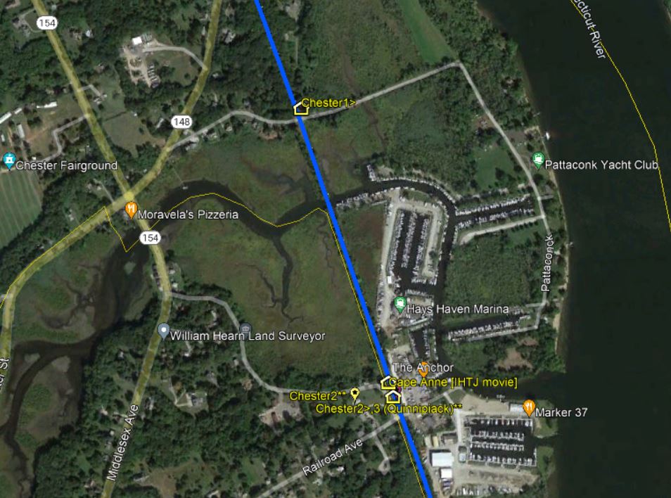
Although no specific mention has yet been found, we assume this standard saltbox station was built early in 1897 to replace the one that burned. The 3/15/1939 addendum to the 1938 SSRR list says an offer of $100 had been and the addendum of 7/19/1939 says the depot was sold on 10/9/1939. The val photo at [1] appears to be dated 8/3/1916 and the PUC shot at [2] was taken on 10/26/1927. The remaining images are undated except for the contemporary photo at [6]. It shows the freight station in commercial use in 2013 across from the remnant of CHESTER1 that the VRR has repurposed as a yard office. [REFS: PP/09/05/1905/02; HC/08/05/1939/16; HC/08/14/1954/6E; HC/08/11/1957/ 18C1; C158][rev010318]
Although no specific mention has yet been found, we assume this standard saltbox station was built early in 1897 to replace the one that burned. The 3/15/1939 addendum to the 1938 SSRR list says an offer of $100 had been and the addendum of 7/19/1939 says the depot was sold on 10/9/1939. The val photo at [1] appears to be dated 8/3/1916 and the PUC shot at [2] was taken on 10/26/1927. The remaining images are undated except for the contemporary photo at [6]. It shows the freight station in commercial use in 2013 across from the remnant of CHESTER1 that the VRR has repurposed as a yard office. [REFS: PP/09/05/1905/02; HC/08/05/1939/16; HC/08/14/1954/6E; HC/08/11/1957/ 18C1; C158][rev010318]

|

|
EAST HAMPTON1 [NHM&W, 1873]
This station was to serve the village in the town of Chatham, which was renamed East Hampton in 1915 to reflect the enclave's commercial importance. [rev070215]
This station was to serve the village in the town of Chatham, which was renamed East Hampton in 1915 to reflect the enclave's commercial importance. [rev070215]

|
|
|
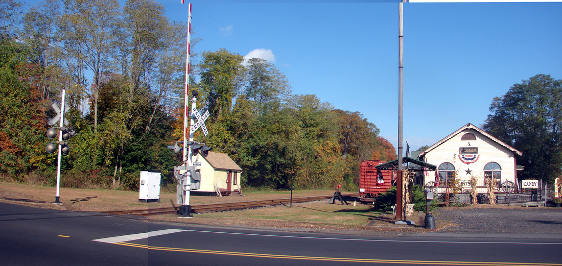
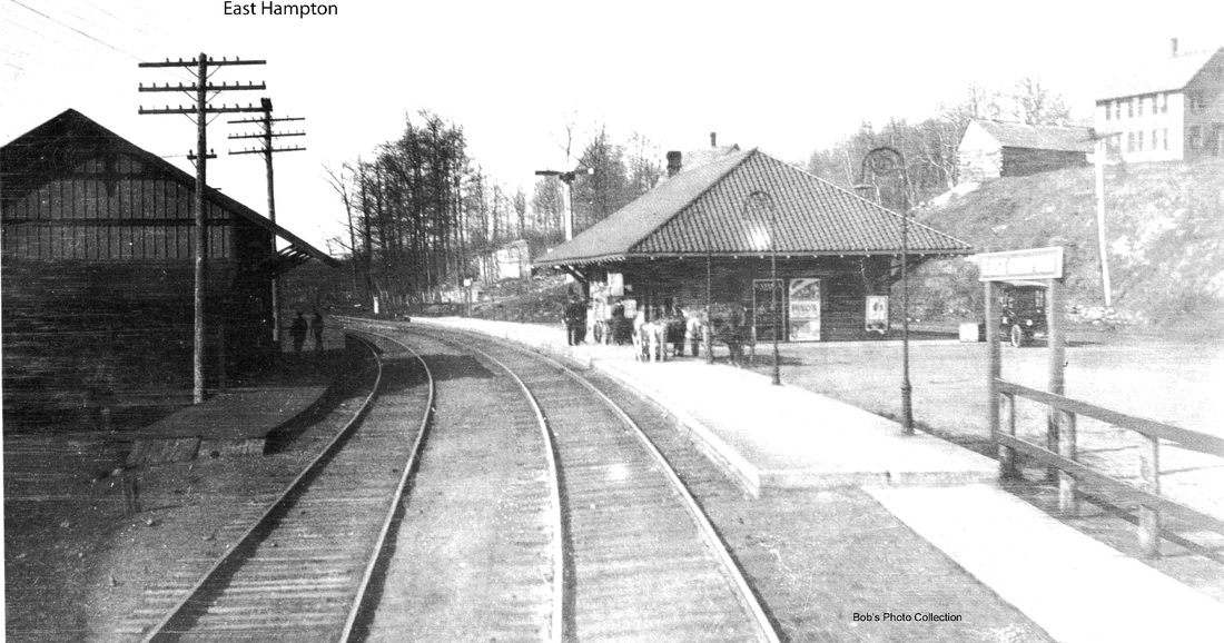
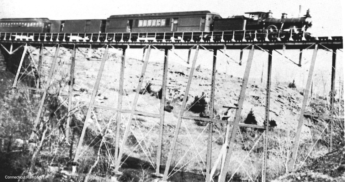
EAST HAMPTON2 [NYNH&H, 1910/11]
The new station is to the left, north of the track, and EAST HAMPTON1, now being used as the freight depot, is on the right on the card at left that is postmarked 12/5/1916. The view is reversed in the photo at middle. The new station was completed between 1910 and 1911, according to the annual report for the latter year. The photo at right is the Rapallo Viaduct in East Hampton, about two miles east of the station. At 1,300 feet in length and 60 feet in height, it was not as impressive as the Lyman Viaduct, at 1,100 feet long and 137 feet high, a mile farther on. Nonetheless, the structure, named for NHM&W director Charles A. Rapallo, was another significant engineering accomplishment and made the Air Line even more celebrated for the twin viaducts. Actually, there was a third viaduct, also filled in, at COBALT. [REFS: NHAR37.1908.8; CRC57.1909.45; HC/10/02/1909/15; NHAR40.1911.11; R49]
The new station is to the left, north of the track, and EAST HAMPTON1, now being used as the freight depot, is on the right on the card at left that is postmarked 12/5/1916. The view is reversed in the photo at middle. The new station was completed between 1910 and 1911, according to the annual report for the latter year. The photo at right is the Rapallo Viaduct in East Hampton, about two miles east of the station. At 1,300 feet in length and 60 feet in height, it was not as impressive as the Lyman Viaduct, at 1,100 feet long and 137 feet high, a mile farther on. Nonetheless, the structure, named for NHM&W director Charles A. Rapallo, was another significant engineering accomplishment and made the Air Line even more celebrated for the twin viaducts. Actually, there was a third viaduct, also filled in, at COBALT. [REFS: NHAR37.1908.8; CRC57.1909.45; HC/10/02/1909/15; NHAR40.1911.11; R49]

|
|

|
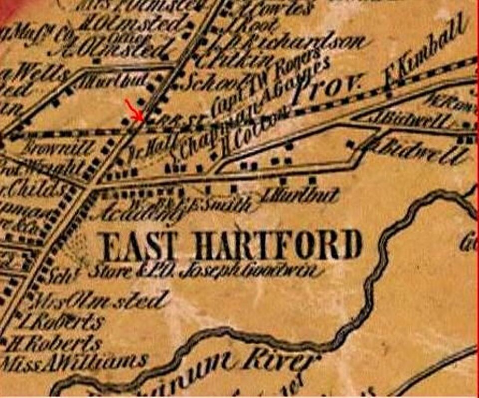
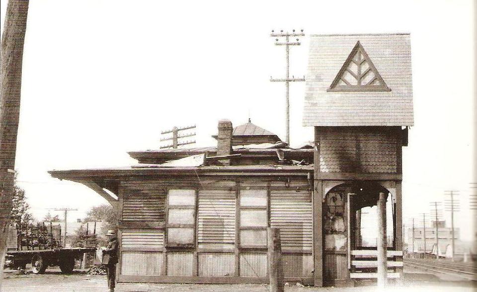
EAST HARTFORD1 [HP&F, 1849]
The Courant reporter who rode the inaugural HP&F train eastward from Hartford to Willimantic on 11/10/1849 described the new depots along the line as "neat Gothic erections, in very good taste; this imitation of the Antique does very well in Railway Architecture, and, at the same expense, gives us picturesque buildings, to ornament the country prospects." While we do not know exactly he meant by that style, the reporter implies a similarity of design along the line and his 'Gothic' may well have been a cross-gabled structure like the HP&F's 1855 BRISTOL1 depot, seen at [1], the only photo showing this style of first-generation HP&F station. Our red arrow on the 1855HC map at [2] points to what seems to be intended as the block marking the station, north of the track right at the edge of Main St. The 1869 map at [3] shows it slightly eastward and south of the track. It is possible it was moved or we think equally likely that the greater detail on the later map places it correctly. No actual images have yet been found of EAST HARTFORD1 and its fate is unknown. Timewise, it must have lasted until 1882 when EAST HARTFORD2 replaced it. [REFS: HDC/11/13/1849/02; HDC/06/21/1881/02; CRC29.1882.34; NHER/09/09/1882/01; NHER/11/02/1882/04; NHER/02/07/1883/04; TVH/03/15/1883/04; HDC/06/09/1883/04][rev101820]
The Courant reporter who rode the inaugural HP&F train eastward from Hartford to Willimantic on 11/10/1849 described the new depots along the line as "neat Gothic erections, in very good taste; this imitation of the Antique does very well in Railway Architecture, and, at the same expense, gives us picturesque buildings, to ornament the country prospects." While we do not know exactly he meant by that style, the reporter implies a similarity of design along the line and his 'Gothic' may well have been a cross-gabled structure like the HP&F's 1855 BRISTOL1 depot, seen at [1], the only photo showing this style of first-generation HP&F station. Our red arrow on the 1855HC map at [2] points to what seems to be intended as the block marking the station, north of the track right at the edge of Main St. The 1869 map at [3] shows it slightly eastward and south of the track. It is possible it was moved or we think equally likely that the greater detail on the later map places it correctly. No actual images have yet been found of EAST HARTFORD1 and its fate is unknown. Timewise, it must have lasted until 1882 when EAST HARTFORD2 replaced it. [REFS: HDC/11/13/1849/02; HDC/06/21/1881/02; CRC29.1882.34; NHER/09/09/1882/01; NHER/11/02/1882/04; NHER/02/07/1883/04; TVH/03/15/1883/04; HDC/06/09/1883/04][rev101820]
EAST HARTFORD2 [NY&NE, 1882]
This architectural style, seen elsewhere only in the 1881 FORESTVILLE2 depot, is unique and thus far unattributed and unexplained. Windows in the tower would certainly have given the operator a great vantage point but we see none and have to conclude the appendage was purely ornamental. Beckwith's Almanac, the venerable New Haven publication covering statewide events in its annual chronology drawn from state newspapers, says that on 3/1/1883 "the passenger depot of the N. Y. & N. E. R. R. at East Hartford burned. It was recently finished and contained telegraph apparatus, tickets, express packages and some freight; loss $2,000." Other newspaper reports corroborate this event but the gem here is the phrase "recently finished." It virtually assures us that a depot matching FORESTVILLE2 was built here. It may be recalled that by 1881, the newspaper reported that a replacement for EAST HARTFORD1 was in the offing when it said that the NY&NE had "included in its estimates for this year, a sum for a new passenger station at East Hartford, but it will hardly be reached until next season." Thus, it seems that the new station went up perhaps late in 1882, burned down early in the next year, and was replaced by the "shed" in our next entry. Perhaps this is why the 1883 annual report says nothing about a new station. This borrowed image of the later station is what we think EAST HARTFORD2 looked like. [REFS: HDC/06/21/1881/02; WDS/03/02/1883/01; FVH/03/15/1883/04; BA.37.1884. 00 (3/1/1883); NYNEAR8.1883.17][rev101820]
This architectural style, seen elsewhere only in the 1881 FORESTVILLE2 depot, is unique and thus far unattributed and unexplained. Windows in the tower would certainly have given the operator a great vantage point but we see none and have to conclude the appendage was purely ornamental. Beckwith's Almanac, the venerable New Haven publication covering statewide events in its annual chronology drawn from state newspapers, says that on 3/1/1883 "the passenger depot of the N. Y. & N. E. R. R. at East Hartford burned. It was recently finished and contained telegraph apparatus, tickets, express packages and some freight; loss $2,000." Other newspaper reports corroborate this event but the gem here is the phrase "recently finished." It virtually assures us that a depot matching FORESTVILLE2 was built here. It may be recalled that by 1881, the newspaper reported that a replacement for EAST HARTFORD1 was in the offing when it said that the NY&NE had "included in its estimates for this year, a sum for a new passenger station at East Hartford, but it will hardly be reached until next season." Thus, it seems that the new station went up perhaps late in 1882, burned down early in the next year, and was replaced by the "shed" in our next entry. Perhaps this is why the 1883 annual report says nothing about a new station. This borrowed image of the later station is what we think EAST HARTFORD2 looked like. [REFS: HDC/06/21/1881/02; WDS/03/02/1883/01; FVH/03/15/1883/04; BA.37.1884. 00 (3/1/1883); NYNEAR8.1883.17][rev101820]
 Connecticut State Library Archives
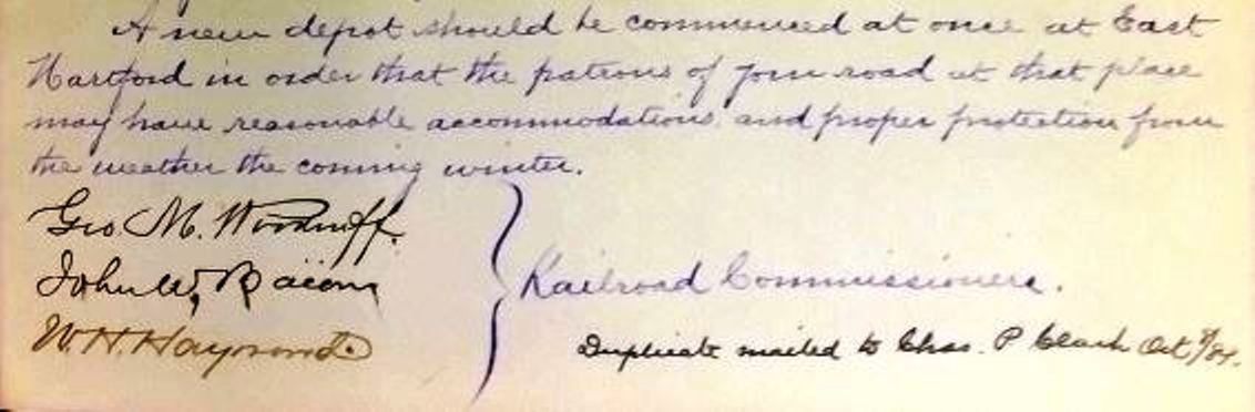
EAST HARTFORD3 [NY&NE, 1883]
A Courant article in June, 1883 reported that "the shed which the railroad company built after the [earlier 1883] depot burnt, has been newly shingled this week, which looks as if it was designed for a permanent fixture. Some think it's good enough for East Hartford." The latter sentence seems to echo a theme seen elsewhere that Hartford's sister town east of the river was rather a stepchild for steam railroad service, a minor stop for passengers who just might as well have taken a carriage or horse car or just walked across the predecessors of the present Connecicut River bridges. While the sources say that new side tracks, turntable, and coaling and watering stations were installed here in 1883 as part of a new NY&NE operations center, they say nothing about any fire or a new passenger depot, even while remarking that one had been built at Willimantic. Apparently, the "shed" that replaced the just-burned EAST HARTFORD2 lay under the official radar and was not deserving of mention. In November, 1884, the paper reported the railroad commissioners saying in their fall inspection of state rail lines that "a new depot at East Hartford should be begun at once," again indicating that the 1883 'shed' was minimal and inadequate. The relevant excerpt of the 10/7/1884 letter from the commissioners to the NY&NE is shown above. Note also that a duplicate copy was sent directly to NY&NE President Charles P. Clark on the following day. In any case, whatever was built as EAST HARTFORD3 would be used until it was replaced in 1888. No photo has yet been found. [REFS: RRC26.282 (11/16/1882); HDC/06/09/1883/04; NYNEAR8.1883.17; HDC/11/12/1884/02; CRC31.1884.19][rev121012, 101820]
A Courant article in June, 1883 reported that "the shed which the railroad company built after the [earlier 1883] depot burnt, has been newly shingled this week, which looks as if it was designed for a permanent fixture. Some think it's good enough for East Hartford." The latter sentence seems to echo a theme seen elsewhere that Hartford's sister town east of the river was rather a stepchild for steam railroad service, a minor stop for passengers who just might as well have taken a carriage or horse car or just walked across the predecessors of the present Connecicut River bridges. While the sources say that new side tracks, turntable, and coaling and watering stations were installed here in 1883 as part of a new NY&NE operations center, they say nothing about any fire or a new passenger depot, even while remarking that one had been built at Willimantic. Apparently, the "shed" that replaced the just-burned EAST HARTFORD2 lay under the official radar and was not deserving of mention. In November, 1884, the paper reported the railroad commissioners saying in their fall inspection of state rail lines that "a new depot at East Hartford should be begun at once," again indicating that the 1883 'shed' was minimal and inadequate. The relevant excerpt of the 10/7/1884 letter from the commissioners to the NY&NE is shown above. Note also that a duplicate copy was sent directly to NY&NE President Charles P. Clark on the following day. In any case, whatever was built as EAST HARTFORD3 would be used until it was replaced in 1888. No photo has yet been found. [REFS: RRC26.282 (11/16/1882); HDC/06/09/1883/04; NYNEAR8.1883.17; HDC/11/12/1884/02; CRC31.1884.19][rev121012, 101820]

UConn Archives & Special Collections
|
|
|
|
George Ford Collection
|
|
 Al Lawrence Collection
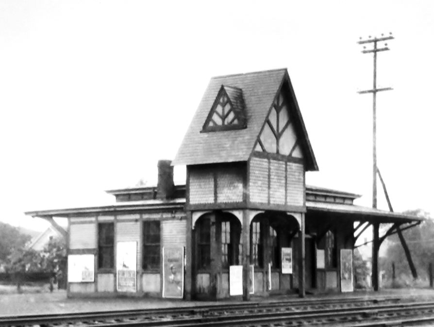
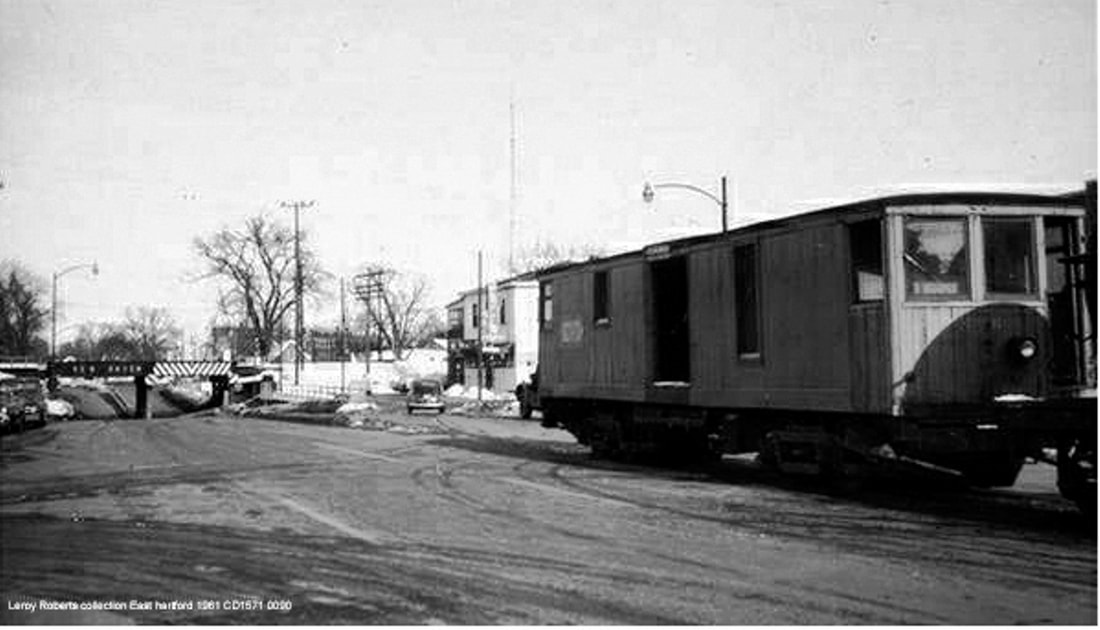
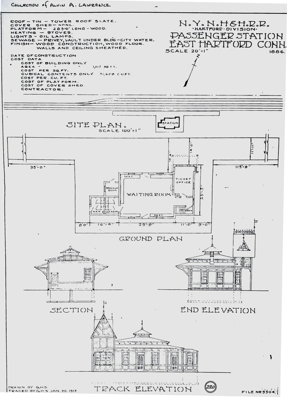
EAST HARTFORD4 [NY&NE, 1888]
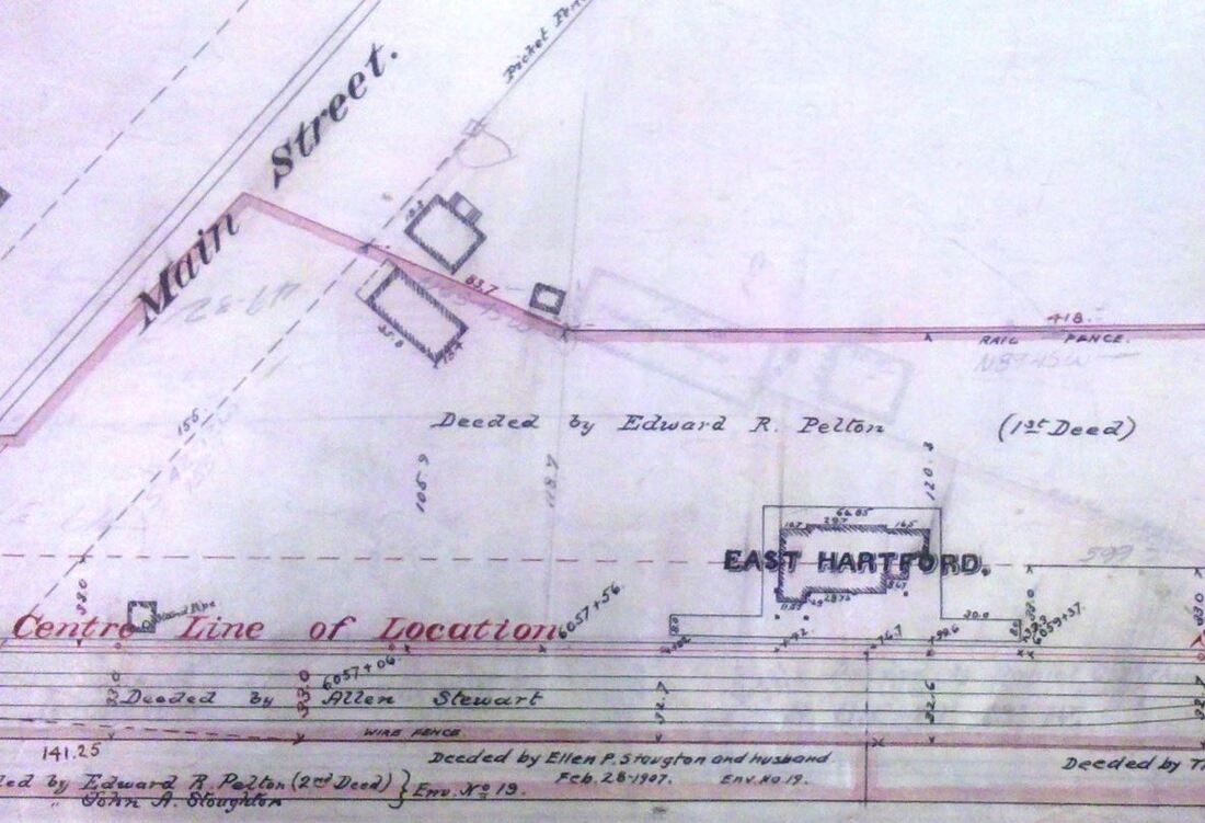
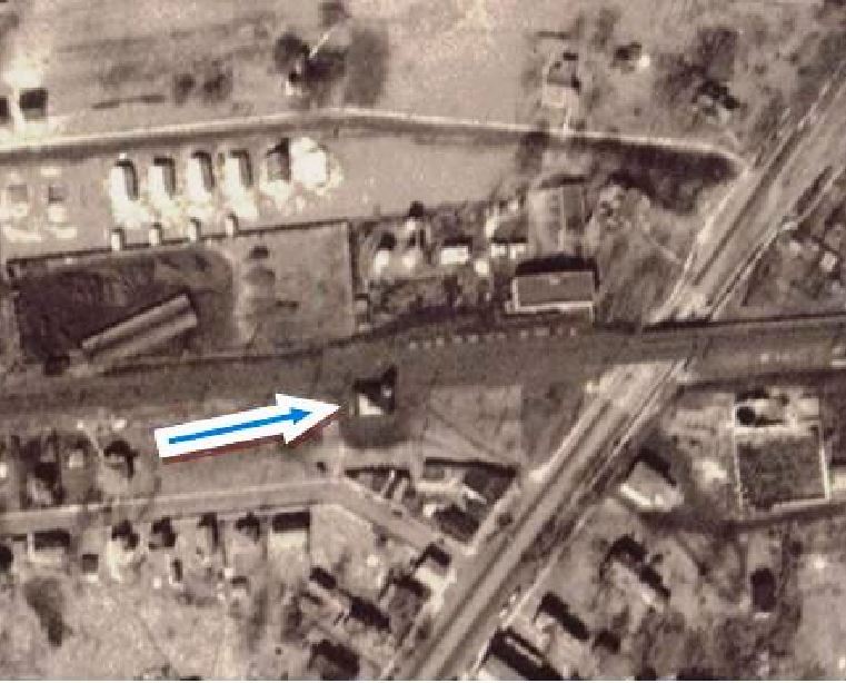
Whatever the earlier plans, the railroad commissioners did not report until 1888 that a new depot had been built, a fact corroborated by the NY&NE annual report. Lewis H. Benton took the shot at [1], his #2150, on 6/24/1928; this is probably the last image before the "old style village depot" was destroyed by fire at noon on Monday 8/19/1929. The Courant article goes on to say that the station "was erected in East Hartford as an accommodation to railroad commuters about 45 years ago" and was closed when passenger service ceased, some time after our 1923TT. We note that 45 years would date it to 1883 corresponding to our previous entry, not 1888; the identical appearance and the 'shed' which intervened from 1883 to 1888 either had been forgotten or overlooked. The image at [2] is from a ca. 1890 NY&NE real estate atlas and looks south at the footprint of this station, with the distinctive tower outcrop in the northeast corner. The 1927 aero view at [3] shows this station at the blue arrow on the west side of the Main St. grade crossing, which was eliminated in 1907. The 1903 map at [4] shows the anticipated proposal to lower the road so that trolley and vehicular traffic could go under the tracks at this busy and dangerous intersection point. The shot at [4] appeared in a Shoreliner article and is said to date to 8/21/1929, which would put it two days after the fire. While this may not show the "blackened shell" the newspaper described, the windows and the tower entrance are boarded up, some scorching is seen, the roof is littered with debris, a delivery truck (debris-laden?) is in the rear, and a policeman is on the scene. After passenger service ended in the mid-1920s, the building had been used as a freight house and still served in limited capacity as such after the fire. Dieselized industrial service on the old Main St. trolley line, as seen in the northward view at [6], was maintained to J.B. Williams in Glastonbury until 1958 and to Pratt & Whitney until 1965. The Main St. railroad bridge in the photo was installed in May, 1907 after much debate on whether the highway or the trolley should go over the railroad or the railroad elevated over both. Much jurisdictional jockeying also occurred later when the Courant reported on 8/23/1967 that the NYNH&H "removed the tracks that ran down the center of the street, in order to salvage the metal. The dirt and grass road bed has been dug up, the ties left where they were, and 'the entire area is now very unsightly.'" The image at [7] is the 1/30/1913 tracing of the architectural plan for EAST HARTFORD4. This copy of the plan was found in the papers of the late Ed Sweeney of Norwood, MA and supplied to us by long-time TCS contributor Richard Fleischer of Newton Centre, MA. The 1886 date works for the 1888 completion but this drawing obviously is owing to the earlier design seen at EAST HARTFORD2, perhaps copied from that plan. [REFS: CRC36.1888.16; NYNEAR13.1888.23; HC/05/02/1907/15; HC//05/08/1907/13; HC/06/07/1907/19; HC/12/19/1907/07; HC/08/21/1929/05; HC/03/19/1930/08; HC/05/06/1958/26; HC/02/09/1967/48A; HC/04/12/1967/30A; HC/08/23/1967/32A; SL31.3.12][rev061716, 101820, 102520. 101721, 103021, 031623]
Whatever the earlier plans, the railroad commissioners did not report until 1888 that a new depot had been built, a fact corroborated by the NY&NE annual report. Lewis H. Benton took the shot at [1], his #2150, on 6/24/1928; this is probably the last image before the "old style village depot" was destroyed by fire at noon on Monday 8/19/1929. The Courant article goes on to say that the station "was erected in East Hartford as an accommodation to railroad commuters about 45 years ago" and was closed when passenger service ceased, some time after our 1923TT. We note that 45 years would date it to 1883 corresponding to our previous entry, not 1888; the identical appearance and the 'shed' which intervened from 1883 to 1888 either had been forgotten or overlooked. The image at [2] is from a ca. 1890 NY&NE real estate atlas and looks south at the footprint of this station, with the distinctive tower outcrop in the northeast corner. The 1927 aero view at [3] shows this station at the blue arrow on the west side of the Main St. grade crossing, which was eliminated in 1907. The 1903 map at [4] shows the anticipated proposal to lower the road so that trolley and vehicular traffic could go under the tracks at this busy and dangerous intersection point. The shot at [4] appeared in a Shoreliner article and is said to date to 8/21/1929, which would put it two days after the fire. While this may not show the "blackened shell" the newspaper described, the windows and the tower entrance are boarded up, some scorching is seen, the roof is littered with debris, a delivery truck (debris-laden?) is in the rear, and a policeman is on the scene. After passenger service ended in the mid-1920s, the building had been used as a freight house and still served in limited capacity as such after the fire. Dieselized industrial service on the old Main St. trolley line, as seen in the northward view at [6], was maintained to J.B. Williams in Glastonbury until 1958 and to Pratt & Whitney until 1965. The Main St. railroad bridge in the photo was installed in May, 1907 after much debate on whether the highway or the trolley should go over the railroad or the railroad elevated over both. Much jurisdictional jockeying also occurred later when the Courant reported on 8/23/1967 that the NYNH&H "removed the tracks that ran down the center of the street, in order to salvage the metal. The dirt and grass road bed has been dug up, the ties left where they were, and 'the entire area is now very unsightly.'" The image at [7] is the 1/30/1913 tracing of the architectural plan for EAST HARTFORD4. This copy of the plan was found in the papers of the late Ed Sweeney of Norwood, MA and supplied to us by long-time TCS contributor Richard Fleischer of Newton Centre, MA. The 1886 date works for the 1888 completion but this drawing obviously is owing to the earlier design seen at EAST HARTFORD2, perhaps copied from that plan. [REFS: CRC36.1888.16; NYNEAR13.1888.23; HC/05/02/1907/15; HC//05/08/1907/13; HC/06/07/1907/19; HC/12/19/1907/07; HC/08/21/1929/05; HC/03/19/1930/08; HC/05/06/1958/26; HC/02/09/1967/48A; HC/04/12/1967/30A; HC/08/23/1967/32A; SL31.3.12][rev061716, 101820, 102520. 101721, 103021, 031623]
|
|
|
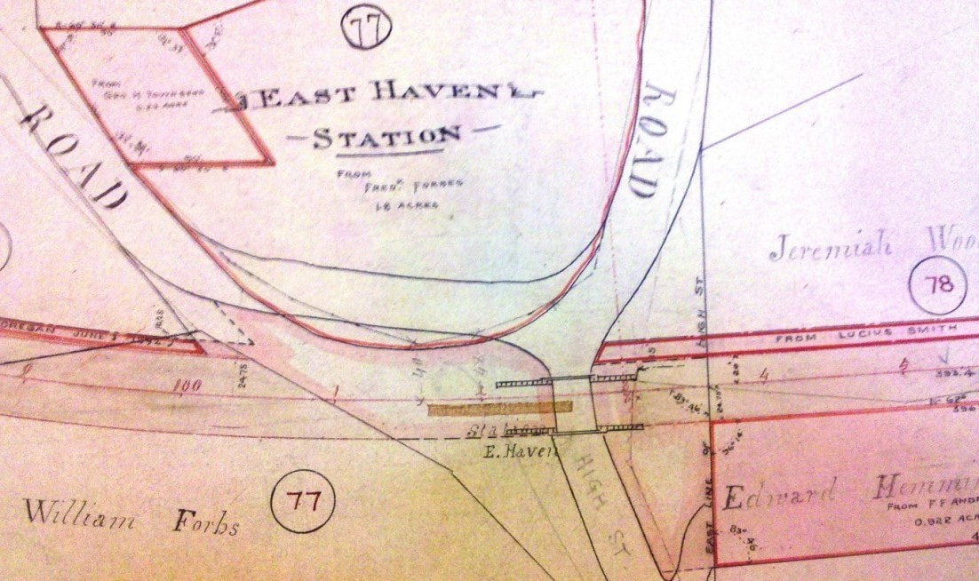
EAST HAVEN1 [NH&NL, 1852; depot, 1866]
The stop was established in 1852 by the NH&NL. Timetables from the start show this as a scheduled stop but by 1858 both daily trains each way had to be flagged. On 8/13/1866, a group of 34 citizens of East Haven petitioned the railroad commissioners to have more trains stop here because "we have no depot closer than Fair Haven, (3 miles) on the West and Branford (3 miles) on the East." At the hearing on 9/12/1866, the Shore Line president appeared and promised that all accommodation trains would stop "'... providing that the citizens of East Haven should build a suitable platform, and depot, at their own expense, and keep it in order free of cost to the Railway company.' The above condition was cordially assented to and accepted by those who appeared for the petitioners." As per the president's words, we have to infer that there were no passenger facilities here at all and that the railroad, which had built them in several other towns, was not about to favor the folks here with one. This seems to support Rockey's assertion that the fledgling road was "inclined not to give much accommodation to East Haven." A mere month after the hearing, the newspaper informs us that "... a new depot has recently been erected in the town of East Haven, for the convenience of the public. All the accommodation trains will hereafter stop at that station." The small depot at [1] was presumably the result and we assume was built at public expense. The stop is seen on the 1856 map at [2] and the 1868 Beers New Haven County atlas at [3]. Note that on the latter it is marked as a flag station. There is a slight variance in location between the two maps. A cutting back of Mullen Hill, which forced a curve in the original trackage, and straightening of the ROW may account for this and possibly for the abandonment of this depot as well by 1874, of which event we find no other cause. [REFS: RRC5.30 (9/12/1866); CCO/10/13/1866/01; R1.237][rev011518]
The stop was established in 1852 by the NH&NL. Timetables from the start show this as a scheduled stop but by 1858 both daily trains each way had to be flagged. On 8/13/1866, a group of 34 citizens of East Haven petitioned the railroad commissioners to have more trains stop here because "we have no depot closer than Fair Haven, (3 miles) on the West and Branford (3 miles) on the East." At the hearing on 9/12/1866, the Shore Line president appeared and promised that all accommodation trains would stop "'... providing that the citizens of East Haven should build a suitable platform, and depot, at their own expense, and keep it in order free of cost to the Railway company.' The above condition was cordially assented to and accepted by those who appeared for the petitioners." As per the president's words, we have to infer that there were no passenger facilities here at all and that the railroad, which had built them in several other towns, was not about to favor the folks here with one. This seems to support Rockey's assertion that the fledgling road was "inclined not to give much accommodation to East Haven." A mere month after the hearing, the newspaper informs us that "... a new depot has recently been erected in the town of East Haven, for the convenience of the public. All the accommodation trains will hereafter stop at that station." The small depot at [1] was presumably the result and we assume was built at public expense. The stop is seen on the 1856 map at [2] and the 1868 Beers New Haven County atlas at [3]. Note that on the latter it is marked as a flag station. There is a slight variance in location between the two maps. A cutting back of Mullen Hill, which forced a curve in the original trackage, and straightening of the ROW may account for this and possibly for the abandonment of this depot as well by 1874, of which event we find no other cause. [REFS: RRC5.30 (9/12/1866); CCO/10/13/1866/01; R1.237][rev011518]
|
|
New Haven Museum
|
East Haven Historical Society
|
East Haven Historical Society
|
|
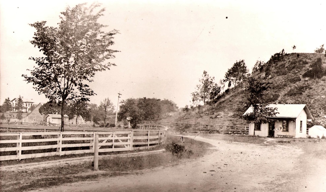
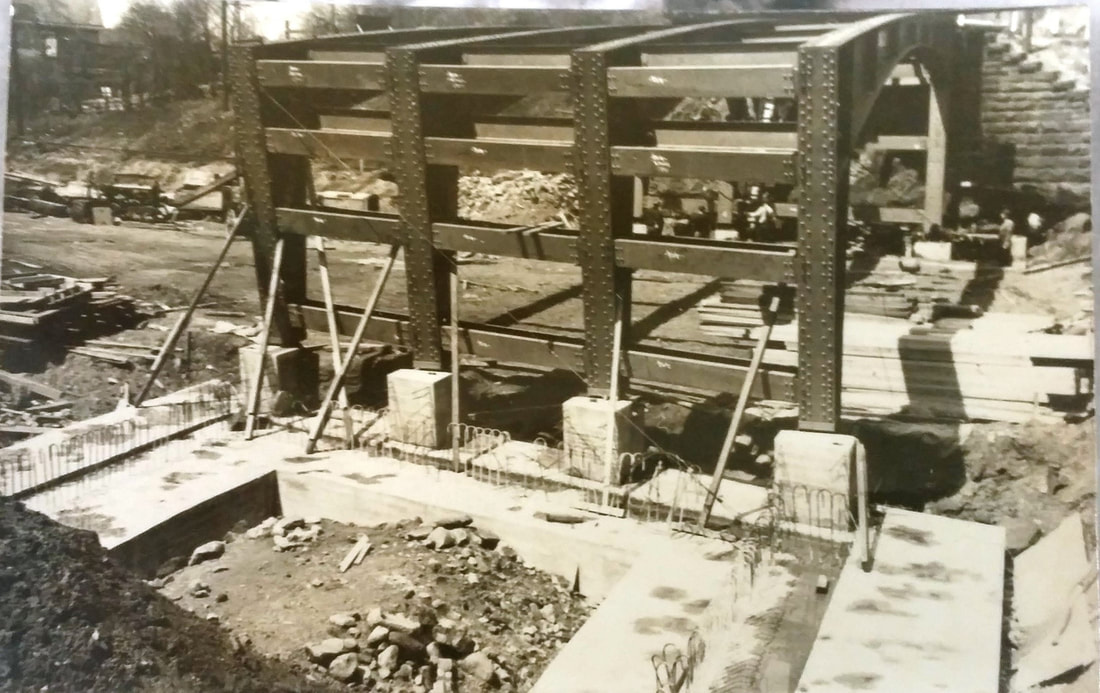
EAST HAVEN2 [NYNH&H, 1873]
The 1874 railroad commissioners' report, issued in May and covering the previous year, tells us that a new station was built here, likely in 1873. It is presumably the one shown at [1] on the slightly relocated line at the foot of Mullen Hill. EAST HAVEN1 is also shown in the wider shot at [2], possibly on the dip in the earlier ROW. The real estate map at [3] shows the station platform under the new bridge which was built in 1889 to eliminate the dangerous grade crossing where High, North High and Laurel Sts. meet. The shot at [4] shows the construction in progress. Interestingly, the town fought the improvement out of fear that it would have to split the cost of the bridge, one person testifying that there was no danger to life at these crossings and the one death he had heard of was the deceased's own fault. Our understanding is that the cost was levied on the railroad or the municipality depending on who asked for the improvement; if both, then the cost was split. In any case, common sense prevailed and the bridge was built. In an unusual outcome on 3/12/1889, "... the East Haven band turned out with full members and dedicated the new bridge recently erected at High Street, over the Shore Line railroad." We are thankful that this celebration was held for there is scant mention of the completion that we have found otherwise. As a result of the bridge construction, the old station location had to be abandoned and the railroad commissioners' records document their approval. And so EAST HAVEN2 was moved a few hundred feet east where it is seen at [5] in 1890 with the completed High St. bridge to the west. The 1893 map at [6] shows the depot at its new location. The similar appearance of the structure in the 1917 val photo at [7] seems to verify that EAST HAVEN2 was left in place at its second location, elevated and given a raised platform for use as the freight depot. [REFS: CRC21.1874.19; NHJC/06/29/1887/01; RRC37.158 (8/19/1887); RRC37.204 (1/11/1888); NHER/03/14/1889/04][rev011518]
The 1874 railroad commissioners' report, issued in May and covering the previous year, tells us that a new station was built here, likely in 1873. It is presumably the one shown at [1] on the slightly relocated line at the foot of Mullen Hill. EAST HAVEN1 is also shown in the wider shot at [2], possibly on the dip in the earlier ROW. The real estate map at [3] shows the station platform under the new bridge which was built in 1889 to eliminate the dangerous grade crossing where High, North High and Laurel Sts. meet. The shot at [4] shows the construction in progress. Interestingly, the town fought the improvement out of fear that it would have to split the cost of the bridge, one person testifying that there was no danger to life at these crossings and the one death he had heard of was the deceased's own fault. Our understanding is that the cost was levied on the railroad or the municipality depending on who asked for the improvement; if both, then the cost was split. In any case, common sense prevailed and the bridge was built. In an unusual outcome on 3/12/1889, "... the East Haven band turned out with full members and dedicated the new bridge recently erected at High Street, over the Shore Line railroad." We are thankful that this celebration was held for there is scant mention of the completion that we have found otherwise. As a result of the bridge construction, the old station location had to be abandoned and the railroad commissioners' records document their approval. And so EAST HAVEN2 was moved a few hundred feet east where it is seen at [5] in 1890 with the completed High St. bridge to the west. The 1893 map at [6] shows the depot at its new location. The similar appearance of the structure in the 1917 val photo at [7] seems to verify that EAST HAVEN2 was left in place at its second location, elevated and given a raised platform for use as the freight depot. [REFS: CRC21.1874.19; NHJC/06/29/1887/01; RRC37.158 (8/19/1887); RRC37.204 (1/11/1888); NHER/03/14/1889/04][rev011518]

|
|

|
|
|
|
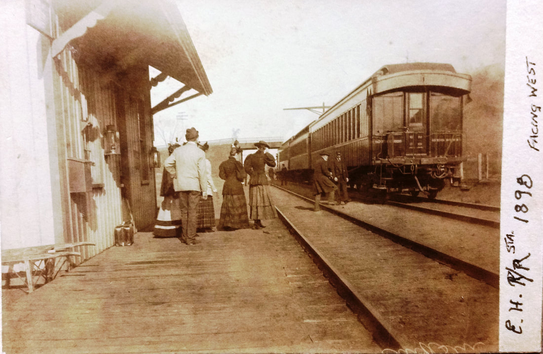
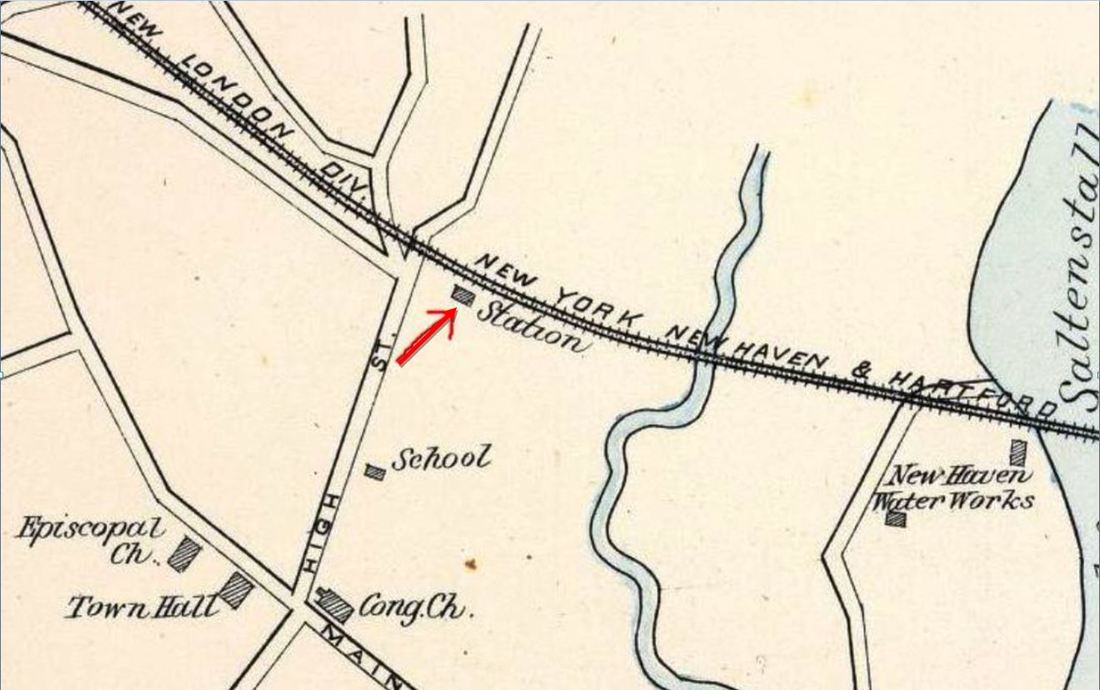
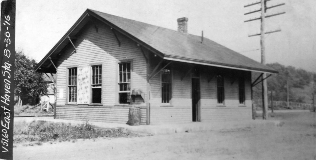
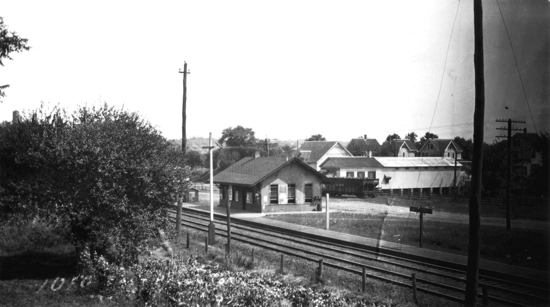
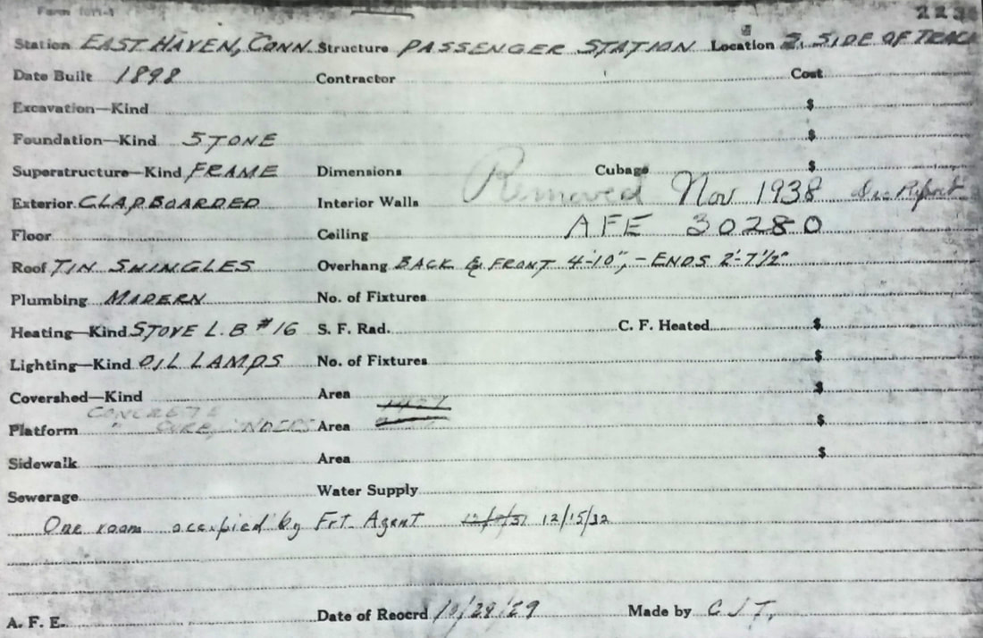
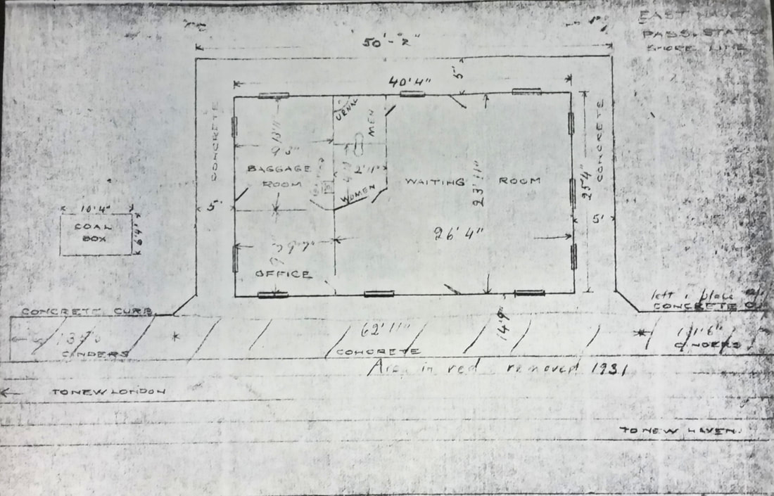
EAST HAVEN3 [NYNH&H, 1896]
The newspaper of 1/28/1896 said that "... the work on the new depot at East Haven is progressing rapidly. The frame has been raised and it will not be very long now before the building is ready for occupancy." While we have not found a report of an actual opening date yet, could it really have taken until 1898 as is stated on the official real estate card at [5]? The eastward-looking shot at [1] appears to show the depot as brand new, with its spotless concrete curbing in place; the 1882 Lake Saltonstall water tower appears in the far distance. The val photo at [2] is dated 8/30/1916. The postcard at [3] looks west toward the 1889 High St. bridge. At [4] is Lewis H. Benton's photo #1010 that was taken in August, 1917. The real estate card at [5] shows this as building #2238 (upper right corner) and the reverse of the card at [6] shows the floor plan of this 25x40-ft structure. The presence of indoor rest rooms is notable for the era and the absence of an agent's bay window is also to be seen. The notation on the front indicates that the building was removed in November, 1938 per Authorization for Expenditure (AFE) #30280. The days of a passenger stop at East Haven were over. Further disposition of the structure is unknown. [REFS: NHJC/01/28/1896/03; 10/20/1938 SSRR: yes][rev011318]
EAST LITCHFIELD [> See LITCHFIELD/N]

|
|
New Haven Museum
|
|

|
New Haven Museum
|
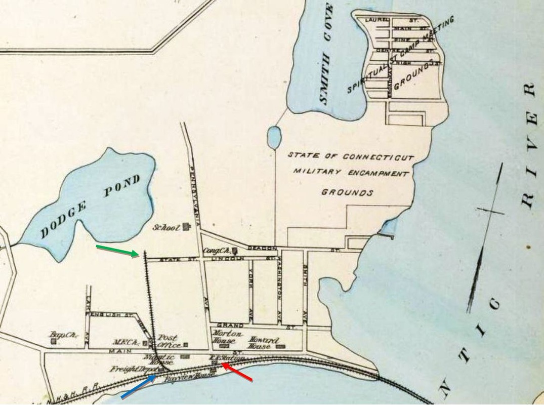
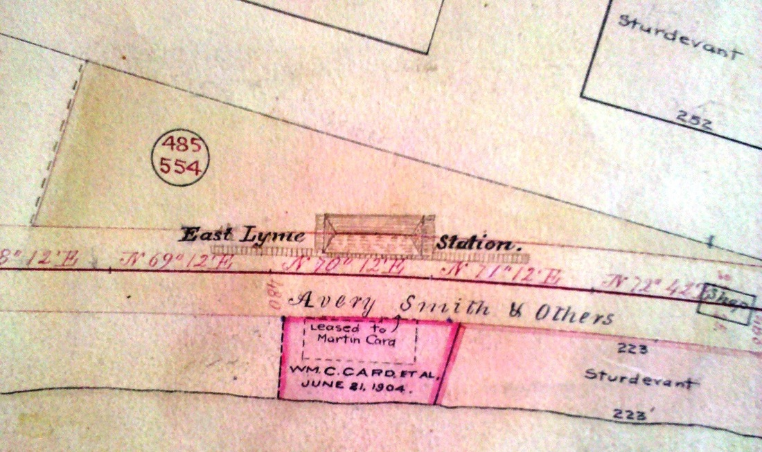
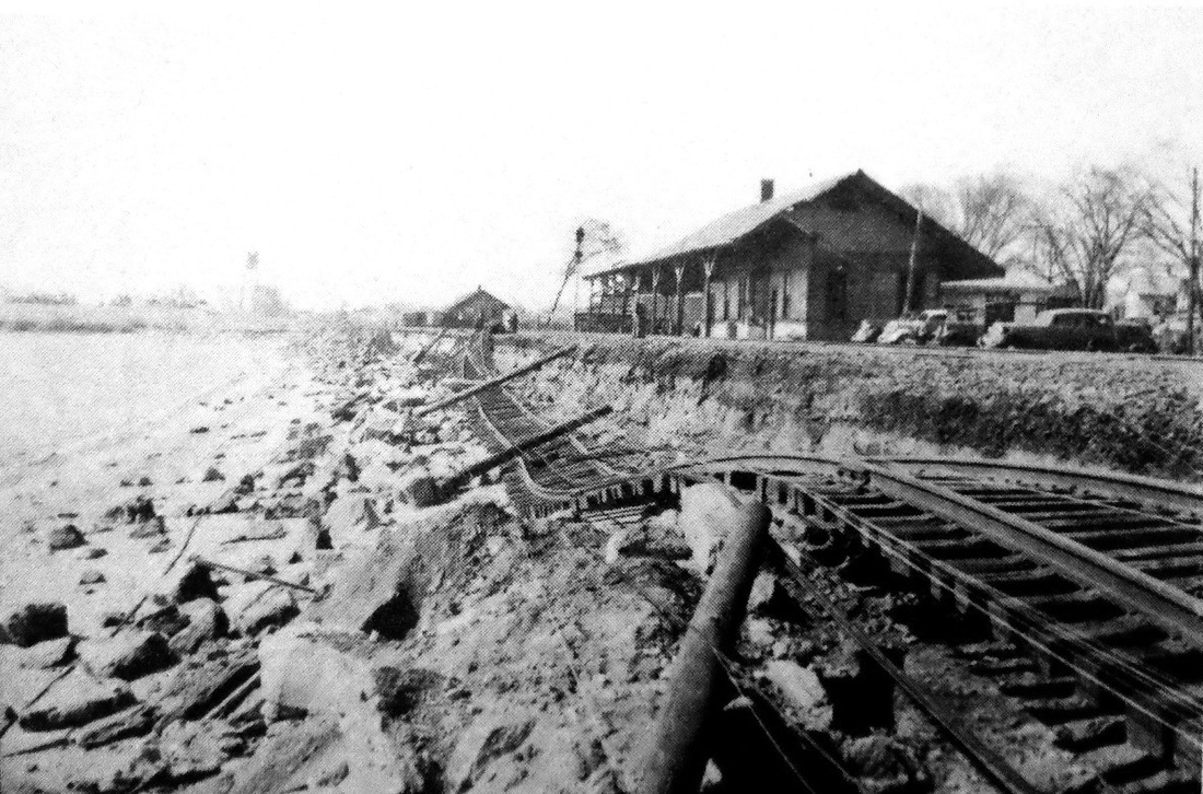
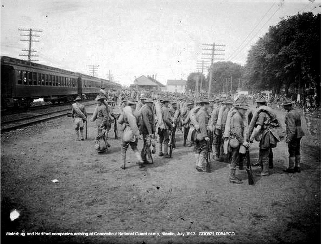
EAST LYME AND NIANTIC1 [NH&NL, 1852]
This stop was established as EAST LYME in the town of the same name when the NH&NL opened in 1852. The 1893 view at [1] is the earliest we have of any station here; it is seen standing north of the tracks across from the Bayview House hotel. The station structure does seem to have a higher profile than 1852 depots like MADISON1 and WESTBROOK1 so it may have been built a little later, perhaps by the NYP&B during its 1858-1862 lease of the line. The signature compass ornament of that company, however shadowy, is seen on the eave at [2]. The July, 1852 timetable at [3] shows separate EAST LYME and NIANTIC listings, but, with no distances given and no further official appearance, the former's life as a separate stop, if any, was short-lived. With the growth of Niantic village as the town's principal population center, especially after state military encampments commenced in 1873, the railroad began to use the EAST LYME AND NIANTIC designation. The 1855 map snippet at [4] shows no depot, which may support a later build date, but our arrow indicates the probable location. The closer look at [5] is from 1868 and shows the station at the foot of Pennsylvania Ave., "the street running north from the depot..." as mentioned in a newspaper article. The Shore Line RR real estate atlas at [6] shows the footprint at a later, post-1890 date. This station burned on 9/23/1898, when the Pawtucket Times reported... "The Railroad Station at Niantic Destroyed by Fire. Yesterday about 2 a.m. the citizens of Niantic were awakened by the cry of fire, and it was soon learned that the railway station on the line of the New York, New Haven and Hartford road was a mass of flames. The citizens and George W. Berry, the station agent, were quickly on hand, but the structure was too far consumed when the blaze was discovered to be saved, and was totally destroyed. The freight house, however, was saved and it is reported that Mr. Berry succeeded in saving some of his books and papers.... The burning of the station, which was an old affair, is supposed to have resulted from sparks from a passing locomotive, as the roof appeared to have first been ignited. The loss is estimated at about $800." That amount was likely a depreciated value for a station that looks as though it would have cost much more to replace at the time. The 1893 Hurd map at [7] shows the station, the freight house, and the 1889 spur that was put in "for the accommodation of public travel during the times that the Connecticut National Guard shall be encamped at said Niantic... the spur track extending from a point on the Shore Line railroad, about five hundred feet distant westerly from the present passenger station at said Niantic and thence running northerly a distance of about two thousand feet, to a point at or near Dodge's Pond." [REFS: NA/09/28/1868/03; Conn. Spec. Act 480 (1889); RRC37.266 (8/17/1889); CEN/09/18/1894/02: reod expansion, remodeling, coversheds; NHER/12/27/1898/10; PT/09/24/1898/07][rev032815, 121818]
This stop was established as EAST LYME in the town of the same name when the NH&NL opened in 1852. The 1893 view at [1] is the earliest we have of any station here; it is seen standing north of the tracks across from the Bayview House hotel. The station structure does seem to have a higher profile than 1852 depots like MADISON1 and WESTBROOK1 so it may have been built a little later, perhaps by the NYP&B during its 1858-1862 lease of the line. The signature compass ornament of that company, however shadowy, is seen on the eave at [2]. The July, 1852 timetable at [3] shows separate EAST LYME and NIANTIC listings, but, with no distances given and no further official appearance, the former's life as a separate stop, if any, was short-lived. With the growth of Niantic village as the town's principal population center, especially after state military encampments commenced in 1873, the railroad began to use the EAST LYME AND NIANTIC designation. The 1855 map snippet at [4] shows no depot, which may support a later build date, but our arrow indicates the probable location. The closer look at [5] is from 1868 and shows the station at the foot of Pennsylvania Ave., "the street running north from the depot..." as mentioned in a newspaper article. The Shore Line RR real estate atlas at [6] shows the footprint at a later, post-1890 date. This station burned on 9/23/1898, when the Pawtucket Times reported... "The Railroad Station at Niantic Destroyed by Fire. Yesterday about 2 a.m. the citizens of Niantic were awakened by the cry of fire, and it was soon learned that the railway station on the line of the New York, New Haven and Hartford road was a mass of flames. The citizens and George W. Berry, the station agent, were quickly on hand, but the structure was too far consumed when the blaze was discovered to be saved, and was totally destroyed. The freight house, however, was saved and it is reported that Mr. Berry succeeded in saving some of his books and papers.... The burning of the station, which was an old affair, is supposed to have resulted from sparks from a passing locomotive, as the roof appeared to have first been ignited. The loss is estimated at about $800." That amount was likely a depreciated value for a station that looks as though it would have cost much more to replace at the time. The 1893 Hurd map at [7] shows the station, the freight house, and the 1889 spur that was put in "for the accommodation of public travel during the times that the Connecticut National Guard shall be encamped at said Niantic... the spur track extending from a point on the Shore Line railroad, about five hundred feet distant westerly from the present passenger station at said Niantic and thence running northerly a distance of about two thousand feet, to a point at or near Dodge's Pond." [REFS: NA/09/28/1868/03; Conn. Spec. Act 480 (1889); RRC37.266 (8/17/1889); CEN/09/18/1894/02: reod expansion, remodeling, coversheds; NHER/12/27/1898/10; PT/09/24/1898/07][rev032815, 121818]

Edward J. Ozog Collection
|
|

|

National Archives
|
|
|
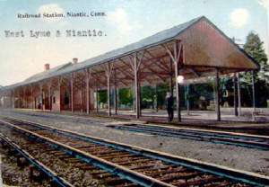
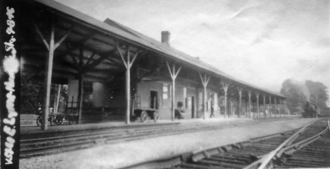
EAST LYME AND NIANTIC2 [NYNH&H, 1899]
The Register ran the following article in December, 1898: "The foundation for the new railway station of the New York, New Haven and Hartford Railroad at Niantic has completed (sic). The floor timbers have been laid and a portion of the frame raised. The building is to be sixty feet long and will require but a short time for its construction, as timbers have been cut and fitted at the Consolidated shops in Middletown, following the custom of the road." (This is interesting commentary!) We have no actual opening date but assume it was early in 1899. Copies of the card at [1] have been seen postmarked 1915. The view at [2], also looking west, shows the coversheds that the railroad commissioners say debuted in 1894. The New London & East Lyme Street Rwy, seen at [3], ran from 1905 to 1924; later a part of the SLER, a connection was made to the CNG spur for delivery of freight. A heavily marked, later-day copy of the 1915 val map at [4] shows the a full wye at the main line. The val photo at [5] is dated 9/8/1916. The image at [6] shows the EAST LYME2 still standing amidst the wreckage of the 1938 hurricane. The military encampments began to take place in Niantic on 9/1/1873 when free use of a 30-acre field for militia maneuvers caused the state to move them from rented land at New London. With the camp name changing to honor the current chief executive as commander of the state military, starting here with Governor Ingersoll (1873-1877), these annual events consisted of drills and marches, mock battles, and parade reviews that brought soldiers as well as thousands of civilian spectators, all coming by train. A 1916 article estimated that 150 passenger, baggage, horse and flat cars would be needed to move the troops, ambulances, guns, signal equipment, and field wagons for that year under orders from Washington. The sham encounters actually had the depot as the target in 1928, when the byline read "Doughty Foot Guard Column 'Saves' Railroad Station and Barber Shop From 'Wreckage,'" this after town authorities had summoned the troops to quell the feigned rioting. Camp Niantic, the home of the Connecticut National Guard, continues as a military training campus today and the spur track still comes off the NEC in this quiet shore village, though now just serving a local lumberyard. The 1912 image at [7] shows troops disembarking, not at the end of the spur but at the depot whence they apparently marched to the camp grounds. The military presence also made this station the scene of soldiers frolicking at the beach, guarding munitions and, on rare occasions, being apprehended as AWOL. The passenger station "being used very little" and the grounds okayed for shopper parking by 1948, by 2/18/1954 the depot had passed into the hands of the Callahan Oil Co. and "the new store spaces in the old railroad station" were nearly ready for occupancy. The one farthest east was reserved for railroad use until a new passenger shelter could be built. A $1M fire, possibly an arson, struck the depot building on 8/22/1970, ruining the four businesses then therein, destroying the Niantic Public Market next door and damaging the roof of the gas station fronting the depot on Main St. Depot demolition began on the morning of 9/3/1970 and likely was completed within a day or two. A 1978 article claiming that "the former railroad station of 25 years ago is now occupied by the Lehigh Gas Station on Main Street..." should be understood as the gas station more or less occupying the old depot site: see next entry. [REFS: MDC/08/05/1873/02; HDC/09/01/1873/02; CRC42.1894.18; HC/06/20/1916/03; NLD/09/15/1917/08; HC/06/30/1928/07; HC/07/08/1939/04; NLD/07/08/1948/07; NLD/02/18/1954/06; HC/08/23/1970/A1A; HC/09/02/1970/35E; NLD/09/03/1970/17; NLD/10/14/1970/01; HC/04/28/1978/21D][rev032815]
The Register ran the following article in December, 1898: "The foundation for the new railway station of the New York, New Haven and Hartford Railroad at Niantic has completed (sic). The floor timbers have been laid and a portion of the frame raised. The building is to be sixty feet long and will require but a short time for its construction, as timbers have been cut and fitted at the Consolidated shops in Middletown, following the custom of the road." (This is interesting commentary!) We have no actual opening date but assume it was early in 1899. Copies of the card at [1] have been seen postmarked 1915. The view at [2], also looking west, shows the coversheds that the railroad commissioners say debuted in 1894. The New London & East Lyme Street Rwy, seen at [3], ran from 1905 to 1924; later a part of the SLER, a connection was made to the CNG spur for delivery of freight. A heavily marked, later-day copy of the 1915 val map at [4] shows the a full wye at the main line. The val photo at [5] is dated 9/8/1916. The image at [6] shows the EAST LYME2 still standing amidst the wreckage of the 1938 hurricane. The military encampments began to take place in Niantic on 9/1/1873 when free use of a 30-acre field for militia maneuvers caused the state to move them from rented land at New London. With the camp name changing to honor the current chief executive as commander of the state military, starting here with Governor Ingersoll (1873-1877), these annual events consisted of drills and marches, mock battles, and parade reviews that brought soldiers as well as thousands of civilian spectators, all coming by train. A 1916 article estimated that 150 passenger, baggage, horse and flat cars would be needed to move the troops, ambulances, guns, signal equipment, and field wagons for that year under orders from Washington. The sham encounters actually had the depot as the target in 1928, when the byline read "Doughty Foot Guard Column 'Saves' Railroad Station and Barber Shop From 'Wreckage,'" this after town authorities had summoned the troops to quell the feigned rioting. Camp Niantic, the home of the Connecticut National Guard, continues as a military training campus today and the spur track still comes off the NEC in this quiet shore village, though now just serving a local lumberyard. The 1912 image at [7] shows troops disembarking, not at the end of the spur but at the depot whence they apparently marched to the camp grounds. The military presence also made this station the scene of soldiers frolicking at the beach, guarding munitions and, on rare occasions, being apprehended as AWOL. The passenger station "being used very little" and the grounds okayed for shopper parking by 1948, by 2/18/1954 the depot had passed into the hands of the Callahan Oil Co. and "the new store spaces in the old railroad station" were nearly ready for occupancy. The one farthest east was reserved for railroad use until a new passenger shelter could be built. A $1M fire, possibly an arson, struck the depot building on 8/22/1970, ruining the four businesses then therein, destroying the Niantic Public Market next door and damaging the roof of the gas station fronting the depot on Main St. Depot demolition began on the morning of 9/3/1970 and likely was completed within a day or two. A 1978 article claiming that "the former railroad station of 25 years ago is now occupied by the Lehigh Gas Station on Main Street..." should be understood as the gas station more or less occupying the old depot site: see next entry. [REFS: MDC/08/05/1873/02; HDC/09/01/1873/02; CRC42.1894.18; HC/06/20/1916/03; NLD/09/15/1917/08; HC/06/30/1928/07; HC/07/08/1939/04; NLD/07/08/1948/07; NLD/02/18/1954/06; HC/08/23/1970/A1A; HC/09/02/1970/35E; NLD/09/03/1970/17; NLD/10/14/1970/01; HC/04/28/1978/21D][rev032815]
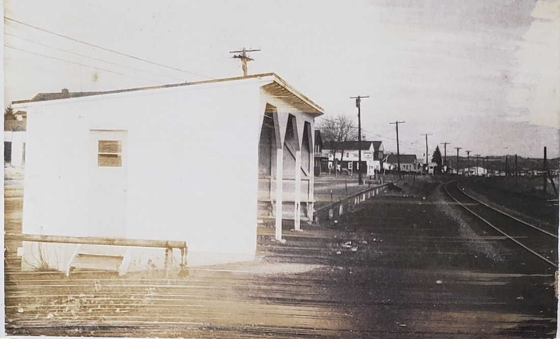
|
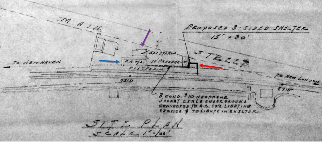
|

|
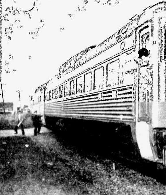 New London Day
EAST LYME AND NIANTIC3 [NYNH&H, 1954]
The 1969 NH-PC real estate transfer album gives us the photo at [1], the only we have seen of the structure here that served as the last NYNH&H station. The July, 1954 draft drawing at [2] shows a 15x30-ft, open-faced shelter that would fit the footprint [red arrow]. EAST LYME AND NIANTIC2 is seen to the west at the blue arrow and the gas station building [purple arrow] is above it on Main St. A 1973 article saying that Penn Central planned to sell or raze Shore Line shelters and platforms, here and at Branford, Madison, Clinton and Stonington, would seem to corroborate the existence of this structure. The shelter stood until 2/18/1978 when, described as a "badly dilapidated waiting shed," the 'old shack' by the Lehigh gas station, "... an eyesore, but also a haven for derelicts...," was torn down by the East Lyme Jaycees as part of a town beautification project. Coincidentally, passenger service was just being reintroduced here by Amtrak which had debuted in 1971 and had discontinued the Clamdigger at that time. The Beacon Hill, consisting of the two Budd cars seen at [4], began running on 4/30/1978 and stopped on demand at "a strip of gravel dumped between two yellow two-by-fours," which we will not dignify at this time as a fourth station. First Selectman George Seebeck was quoted as saying that "the train will slow to five miles per hour as it passes through town so as not to miss any passengers... [who] must flag the train down" and a smiling Conductor J.F. Whalen concurred that "We take a peek and then we keep going." The train was discontinued in 1981. Shore Line East service began on 5/29/1990 but still makes no stops between Saybrook and New London. A 2/18/2015 announcement said that $750G will go toward initial planning and design work for a new train station, site as yet undetermined. The Track 11 Google Earth snippet at [3] shows the area today; the NL&EL trolley is the orange line. [REFS: HC/03/27/1973/13; HC/02/20/1978/23D; HC/04/28/1978/21D; NLD/05/02/1978/09; NLD/02/18/2015/00][rev112818]
The 1969 NH-PC real estate transfer album gives us the photo at [1], the only we have seen of the structure here that served as the last NYNH&H station. The July, 1954 draft drawing at [2] shows a 15x30-ft, open-faced shelter that would fit the footprint [red arrow]. EAST LYME AND NIANTIC2 is seen to the west at the blue arrow and the gas station building [purple arrow] is above it on Main St. A 1973 article saying that Penn Central planned to sell or raze Shore Line shelters and platforms, here and at Branford, Madison, Clinton and Stonington, would seem to corroborate the existence of this structure. The shelter stood until 2/18/1978 when, described as a "badly dilapidated waiting shed," the 'old shack' by the Lehigh gas station, "... an eyesore, but also a haven for derelicts...," was torn down by the East Lyme Jaycees as part of a town beautification project. Coincidentally, passenger service was just being reintroduced here by Amtrak which had debuted in 1971 and had discontinued the Clamdigger at that time. The Beacon Hill, consisting of the two Budd cars seen at [4], began running on 4/30/1978 and stopped on demand at "a strip of gravel dumped between two yellow two-by-fours," which we will not dignify at this time as a fourth station. First Selectman George Seebeck was quoted as saying that "the train will slow to five miles per hour as it passes through town so as not to miss any passengers... [who] must flag the train down" and a smiling Conductor J.F. Whalen concurred that "We take a peek and then we keep going." The train was discontinued in 1981. Shore Line East service began on 5/29/1990 but still makes no stops between Saybrook and New London. A 2/18/2015 announcement said that $750G will go toward initial planning and design work for a new train station, site as yet undetermined. The Track 11 Google Earth snippet at [3] shows the area today; the NL&EL trolley is the orange line. [REFS: HC/03/27/1973/13; HC/02/20/1978/23D; HC/04/28/1978/21D; NLD/05/02/1978/09; NLD/02/18/2015/00][rev112818]

|

|
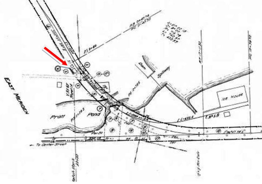
|
EAST MERIDEN1 [M&W, c1904]
This did not become a station stop until between the 1900 timetable in Snow, which does not list it, and the 1904 timetable at [1]. This was the point in Meriden, seen on the 1893 map at [2], where the 1888 M&W line branched off the old M&C and headed to Waterbury. There reportedly was never a depot here, only a platform, and that probably is indicated by our red arrow on the 1915 val map [right]. Financial difficulties would see the successor MW&CR cease operations on 5/30/1896 and be reconstituted as the Middletown, Meriden and Waterbury RR controlled by the NYNH&H. This became the Hartford Division's Meriden Branch and resumed operations on 12/5/1898, with trains running first between Waterbury and Meriden and continuing on to the more populous and profitable Middletown on 1/2/1899. The Consolidated abandoned the track from Westfield to Cromwell, much to the displeasure and legal challenges mounted by that town, and Snow says that the rails were torn out in 1903. Enthusiasm for electric power led this to become became the termination point for steam trains from Waterbury and the starting point in 1907 for trolley service on the old M&C to Westfield. There the cars met those of the Berlin branch which was also being electrified to Middletown. The 1907 timetable at lower left shows EAST MERIDEN JUNCTION as two minutes east of EAST MERIDEN but with no difference in mileage, which seems to mean that the later time was for transfer to the Connecticut Co. cars. By 1908, steam service was cut back further to West Main St. when wires were strung the rest of the way from here on the M&C to a connection with city streetcar tracks coming off Pratt St. Thereafter, riders had to change cars downtown to reach the West Main St. station and continue the trip by steam train to Waterbury. With the 1908 changes, the M&W trackage between east and west Meriden was used only for freight purposes. [REFS: HC/01/01/1898/13; HC/11/07/1898/08; HC/12/08/1898/11; HC/12/31/1898/04; HC/01/18/1899/11; HC/01/20/1899/10; HC/04/17/1901/03; NDN/02/21/1913/02; S14,20,24-29]
This did not become a station stop until between the 1900 timetable in Snow, which does not list it, and the 1904 timetable at [1]. This was the point in Meriden, seen on the 1893 map at [2], where the 1888 M&W line branched off the old M&C and headed to Waterbury. There reportedly was never a depot here, only a platform, and that probably is indicated by our red arrow on the 1915 val map [right]. Financial difficulties would see the successor MW&CR cease operations on 5/30/1896 and be reconstituted as the Middletown, Meriden and Waterbury RR controlled by the NYNH&H. This became the Hartford Division's Meriden Branch and resumed operations on 12/5/1898, with trains running first between Waterbury and Meriden and continuing on to the more populous and profitable Middletown on 1/2/1899. The Consolidated abandoned the track from Westfield to Cromwell, much to the displeasure and legal challenges mounted by that town, and Snow says that the rails were torn out in 1903. Enthusiasm for electric power led this to become became the termination point for steam trains from Waterbury and the starting point in 1907 for trolley service on the old M&C to Westfield. There the cars met those of the Berlin branch which was also being electrified to Middletown. The 1907 timetable at lower left shows EAST MERIDEN JUNCTION as two minutes east of EAST MERIDEN but with no difference in mileage, which seems to mean that the later time was for transfer to the Connecticut Co. cars. By 1908, steam service was cut back further to West Main St. when wires were strung the rest of the way from here on the M&C to a connection with city streetcar tracks coming off Pratt St. Thereafter, riders had to change cars downtown to reach the West Main St. station and continue the trip by steam train to Waterbury. With the 1908 changes, the M&W trackage between east and west Meriden was used only for freight purposes. [REFS: HC/01/01/1898/13; HC/11/07/1898/08; HC/12/08/1898/11; HC/12/31/1898/04; HC/01/18/1899/11; HC/01/20/1899/10; HC/04/17/1901/03; NDN/02/21/1913/02; S14,20,24-29]
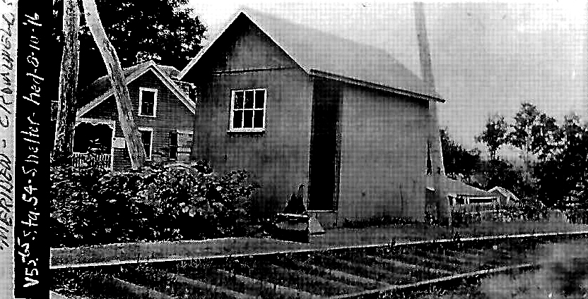
|
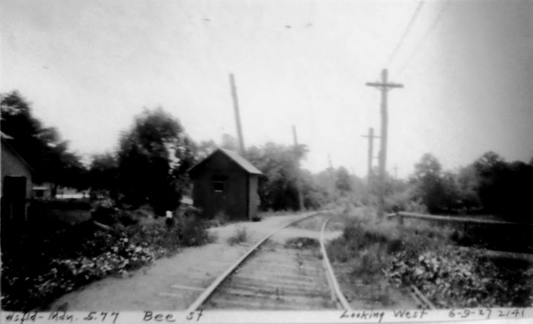
Max Miller Collection
|
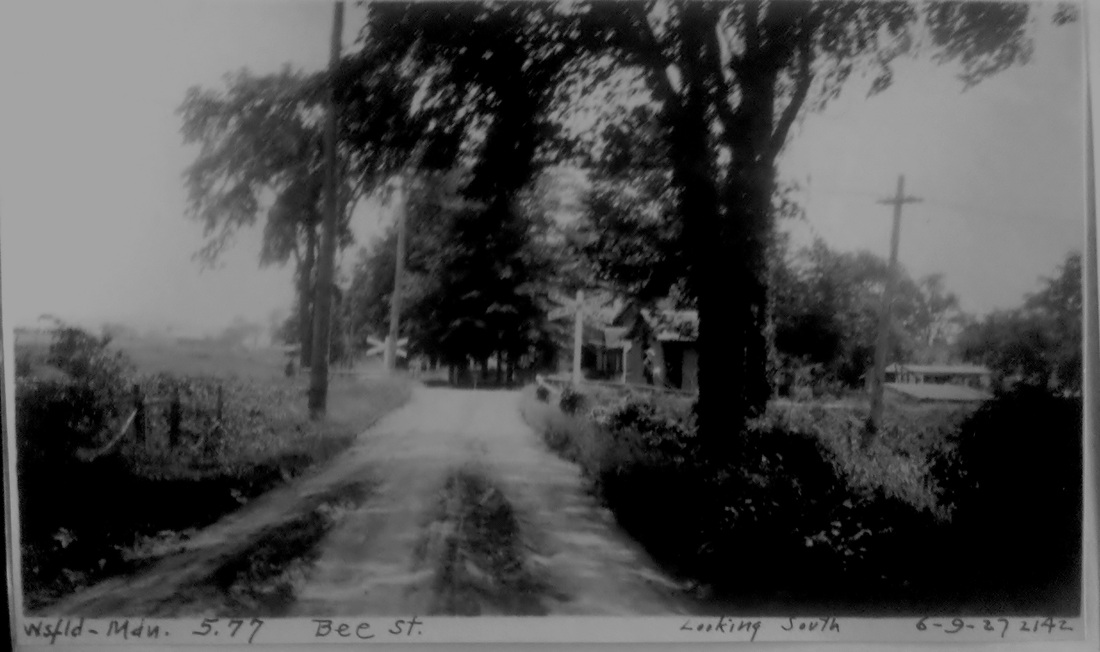
Max Miller Collection
|
EAST MERIDEN2 [Conn. Co., 1906]
Also known as BEE STREET, this station is in the gray category of being on a steam line but only established after service had been converted to trolley between MERIDEN and MIDDLETOWN via WESTFIELD. This was the first stop east of EAST MERIDEN1. Snow says this operation by high-speed electric cars began in 1906 and lasted until 1932 when all Meriden trolley service was replaced by buses which operated along Rte. 6A, today's Rte. 66, to connect the two population centers. A Courant article we found pinpoints the start of service to 7/8/1907 when "seven big interurban trolley cars with M.C.B. wheels" were brought down from East Hartford for use on this line. The station stood in the southwest quadrant of the grade crossing. [REFS: HC/07/05/1907/05; S26][rev031717]
Also known as BEE STREET, this station is in the gray category of being on a steam line but only established after service had been converted to trolley between MERIDEN and MIDDLETOWN via WESTFIELD. This was the first stop east of EAST MERIDEN1. Snow says this operation by high-speed electric cars began in 1906 and lasted until 1932 when all Meriden trolley service was replaced by buses which operated along Rte. 6A, today's Rte. 66, to connect the two population centers. A Courant article we found pinpoints the start of service to 7/8/1907 when "seven big interurban trolley cars with M.C.B. wheels" were brought down from East Hartford for use on this line. The station stood in the southwest quadrant of the grade crossing. [REFS: HC/07/05/1907/05; S26][rev031717]

|
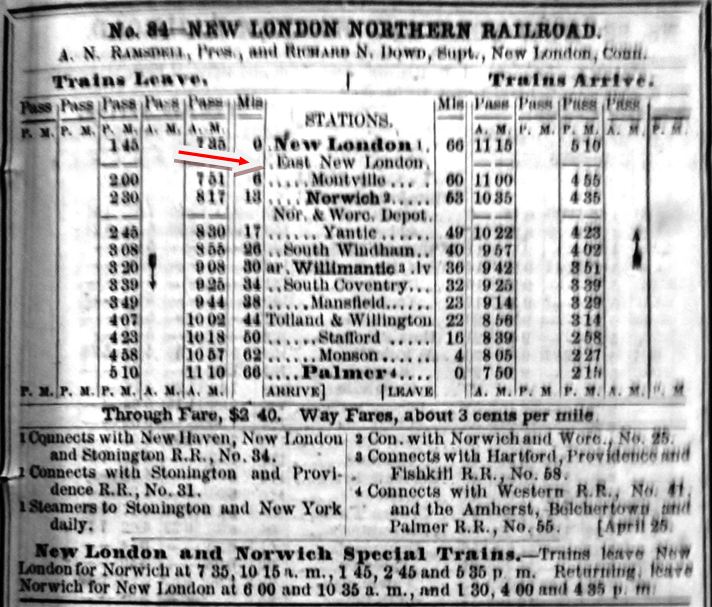
|
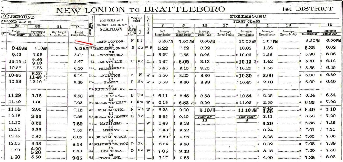
|
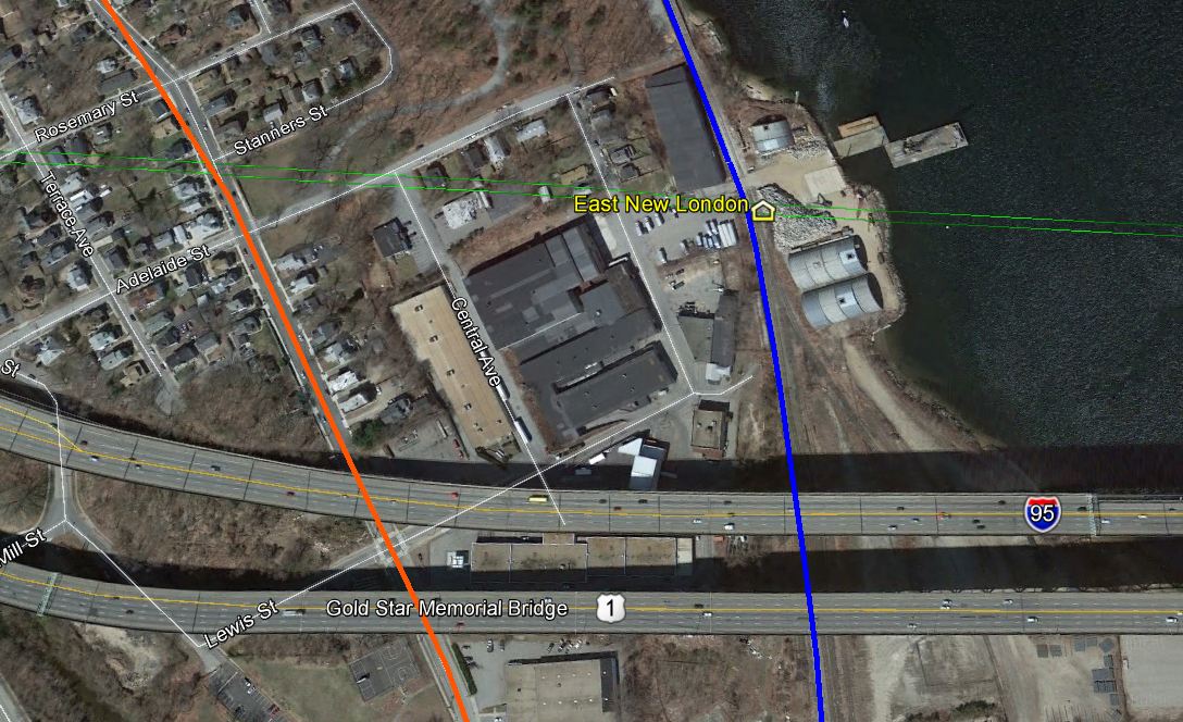
EAST NEW LONDON [CVT, c1900]
This stop is seen in an 1866 American Railway Guide, [2] albeit with no trains stopping here, and thereafter on some ca. 1900 ETTs [3]. This was one mile above Union Station and we are not sure exactly what years this was a stop. The arrow on the 1911 aero view map [1] shows the possible structure where passengers waited, as does the icon on the GE map [4]. The NLN historically had extensive facilities here and just below along Winthrop Cove, even more so by this time and was a major employer in this part of the city as well. [REFS: CVT ETT#4 (6/24/1900); CVT ETT#32 (6/25/1911)][rev012314]
This stop is seen in an 1866 American Railway Guide, [2] albeit with no trains stopping here, and thereafter on some ca. 1900 ETTs [3]. This was one mile above Union Station and we are not sure exactly what years this was a stop. The arrow on the 1911 aero view map [1] shows the possible structure where passengers waited, as does the icon on the GE map [4]. The NLN historically had extensive facilities here and just below along Winthrop Cove, even more so by this time and was a major employer in this part of the city as well. [REFS: CVT ETT#4 (6/24/1900); CVT ETT#32 (6/25/1911)][rev012314]
|

|

|
EAST NORWALK1 [NYNH&H, 1885, EB]
This station was built in 1885, as reported by the railroad commissioners and also by the Register, which said that construction was underway in June. The railroad's annual report said that the station here cost $4,000 and that this stop was established for the convenience of residents in the rapidly growing area east of the river. This uniquely attractive station was likely jockeyed a bit during the four-tracking of the 1890s and is seen looking crisp in the 8/20/1916 val photo at left. It looks virtually unchanged in the murky 1939 newspaper photo at middle, with the article accompanying it telling how John Malone, "last of the old time lamp lighters," was still making his rounds in the evenings while 11,000 volts of electricity passed by the station's front door untapped. The aerial photo at right is of the Hat Corporation of America building, with the iconic, roof-top water tower that dominated the scene for years. Also in a 1939 publication, the shot shows the station located on the eastbound side of the tracks, west of the East Ave bridge. [REFS: CRC33.1886.17; NHER/06/03/1885/01; NHAR14.1886.11; BEP/03/19/1939; R50]
This station was built in 1885, as reported by the railroad commissioners and also by the Register, which said that construction was underway in June. The railroad's annual report said that the station here cost $4,000 and that this stop was established for the convenience of residents in the rapidly growing area east of the river. This uniquely attractive station was likely jockeyed a bit during the four-tracking of the 1890s and is seen looking crisp in the 8/20/1916 val photo at left. It looks virtually unchanged in the murky 1939 newspaper photo at middle, with the article accompanying it telling how John Malone, "last of the old time lamp lighters," was still making his rounds in the evenings while 11,000 volts of electricity passed by the station's front door untapped. The aerial photo at right is of the Hat Corporation of America building, with the iconic, roof-top water tower that dominated the scene for years. Also in a 1939 publication, the shot shows the station located on the eastbound side of the tracks, west of the East Ave bridge. [REFS: CRC33.1886.17; NHER/06/03/1885/01; NHAR14.1886.11; BEP/03/19/1939; R50]

Dave Peters Collection
EAST NORWALK2 [NYNH&H, c1897, WB]
The land that we know was acquired here on 11/2/1891 was for this station that was built as part of the four-tracking improvement program completed by 1897. This station on the westbound side is seen here in 1916, north of the mainline and east of the East Ave. bridge. [REFS: RRC NYNH docs]
The land that we know was acquired here on 11/2/1891 was for this station that was built as part of the four-tracking improvement program completed by 1897. This station on the westbound side is seen here in 1916, north of the mainline and east of the East Ave. bridge. [REFS: RRC NYNH docs]

Connecticut Historical Society
|
|

|
EAST NORWALK3 [NYNH&H, c1930?, WB]
The photo at left looks toward the west with the Hat Corporation building in the background. The middle photo looks east at this new station that replaced EAST NORWALK2. The shot at right is a Charlie Gunn photo, taken on 6/3/1955. It also looks east and across the tracks to EAST NORWALK3 just past the East Ave. bridge.
The photo at left looks toward the west with the Hat Corporation building in the background. The middle photo looks east at this new station that replaced EAST NORWALK2. The shot at right is a Charlie Gunn photo, taken on 6/3/1955. It also looks east and across the tracks to EAST NORWALK3 just past the East Ave. bridge.

|
|
EAST NORWALK4 [NYNH&H, c1950?, EB]
At some point after the 1939 photo of EAST NORWALK2 was taken, the station was removed and replaced by the small shelter seen in the distance on the eastbound side of the tracks, again in front of HCoA. Older folks will remember the Factory Store in Norwalk. As one of the early discount retailers, the Hat Corporation of America's outlet store here offered 50% off its popular headgear products in the days when everyone still wore hats. Broader ranges of merchandise followed and the tradition continues today with the Factory Outlets at Norwalk on the same property. The photo at right looks eastward.
At some point after the 1939 photo of EAST NORWALK2 was taken, the station was removed and replaced by the small shelter seen in the distance on the eastbound side of the tracks, again in front of HCoA. Older folks will remember the Factory Store in Norwalk. As one of the early discount retailers, the Hat Corporation of America's outlet store here offered 50% off its popular headgear products in the days when everyone still wore hats. Broader ranges of merchandise followed and the tradition continues today with the Factory Outlets at Norwalk on the same property. The photo at right looks eastward.

EAST NORWALK5 [MN, 1980s, WB]
This 1980s westbound structure stands where its EAST NORWALK3 predecessor stood. Renovations and cosmetic improvements, including the five-sided eave windows, were completed on 5/24/2005. [REFS: R50]
This 1980s westbound structure stands where its EAST NORWALK3 predecessor stood. Renovations and cosmetic improvements, including the five-sided eave windows, were completed on 5/24/2005. [REFS: R50]

EAST NORWALK6 [MN, 1980s, EB]
This is the platform and enclosure seen to the far left on the eastbound side.
This is the platform and enclosure seen to the far left on the eastbound side.
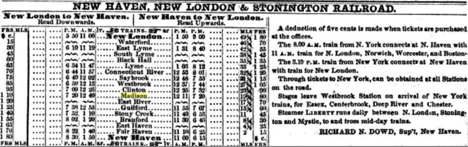
|
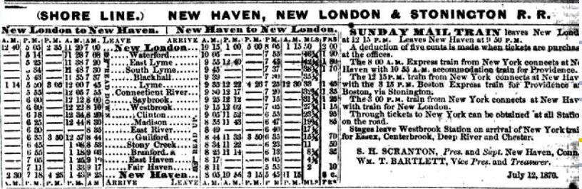
|
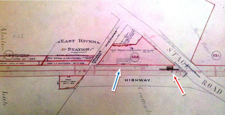
|
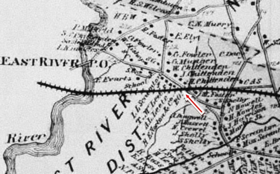
|
EAST RIVER1 [NH&NL, c1858]
The NH&NL opened in 1852 and this station was located about half way between Guilford and Madison, just over the line in the latter town. An 1874 Columbian Register article says West Madison, aka East River, is the "most wide awake go-ahead section of this town and is "at present only a flag station on the Shore Line railway," in spite of requests to the railroad for better freight service and having all trains stop here. The 1858 timetable at upper left, in fact, lists this as an NHNL&S flag stop at least by that time and the 1870 edition at upper right shows three trains a day each way serving this station. Whatever the vacillations in service, the NYNH&H got the message as to the need for more facilities here and in 1875 the paper said that "the powers that be, of the consolidated road, are laying down a side track for freight and other railway accommodations at East River station, and contemplate the building of the new depot at the same place soon. Thanks, and glory be unto them."(!) The map image at lower left is from an official NYNH&H real estate atlas that recorded property acquisitions up into the 1900s and shows two depot footprints. The one the red arrow likely dates prior to 1876 and, in fact, corresponds to the post office location on the 1868 Beers map at lower right. We have no photos yet of whatever structure(s) served here prior to 1876. [REFS: CR/10/31/1874/03; HDC/02/08/1875/04; CR/10/23/1875/03][rev031613]
The NH&NL opened in 1852 and this station was located about half way between Guilford and Madison, just over the line in the latter town. An 1874 Columbian Register article says West Madison, aka East River, is the "most wide awake go-ahead section of this town and is "at present only a flag station on the Shore Line railway," in spite of requests to the railroad for better freight service and having all trains stop here. The 1858 timetable at upper left, in fact, lists this as an NHNL&S flag stop at least by that time and the 1870 edition at upper right shows three trains a day each way serving this station. Whatever the vacillations in service, the NYNH&H got the message as to the need for more facilities here and in 1875 the paper said that "the powers that be, of the consolidated road, are laying down a side track for freight and other railway accommodations at East River station, and contemplate the building of the new depot at the same place soon. Thanks, and glory be unto them."(!) The map image at lower left is from an official NYNH&H real estate atlas that recorded property acquisitions up into the 1900s and shows two depot footprints. The one the red arrow likely dates prior to 1876 and, in fact, corresponds to the post office location on the 1868 Beers map at lower right. We have no photos yet of whatever structure(s) served here prior to 1876. [REFS: CR/10/31/1874/03; HDC/02/08/1875/04; CR/10/23/1875/03][rev031613]
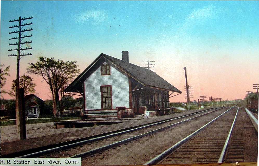
|
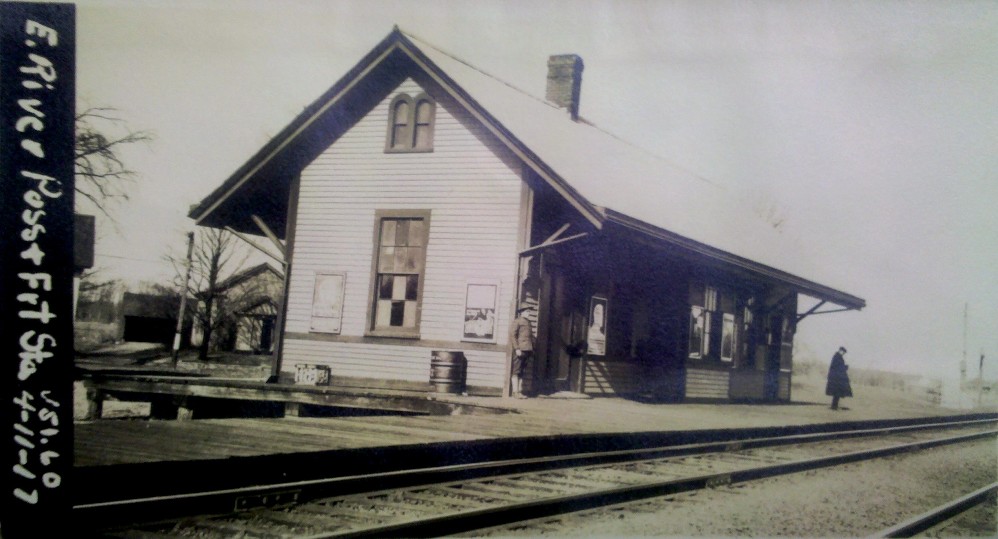
|
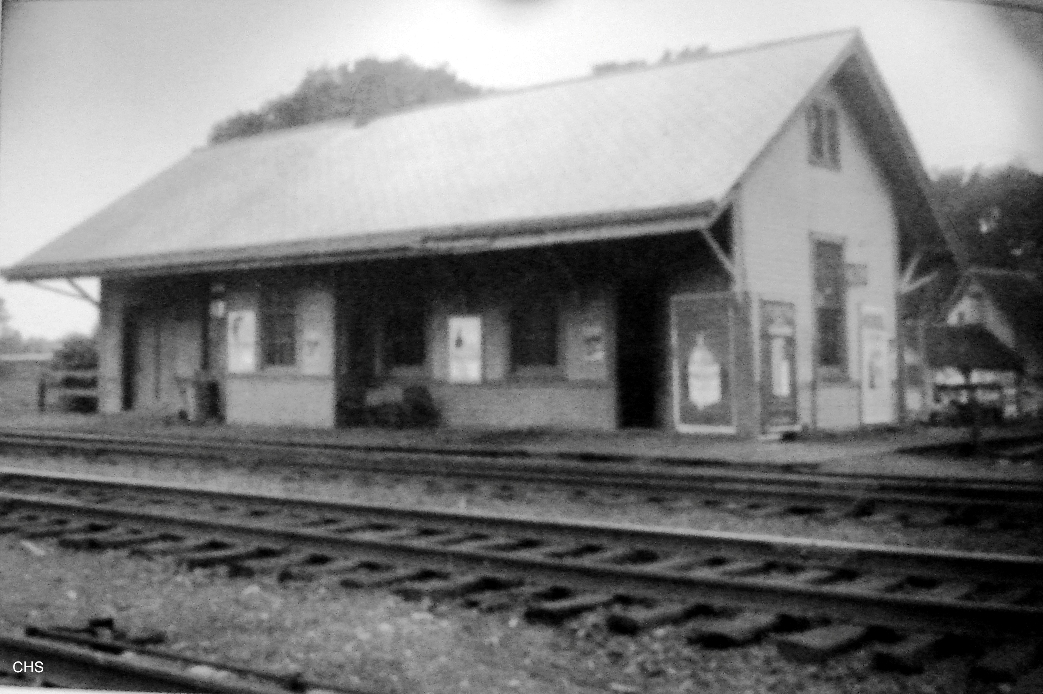
Connecticut Historical Society
|
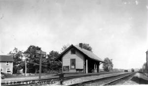
EAST RIVER2 [NYNH&H, 1876]
Rockey, writing his History of New Haven County in 1892, says "a station was first located" here in 1871, but "for lack of patronage it was soon discontinued. In 1876 the present station was opened, and the place since that time grown to its present condition as a business point." While he seems to have been unaware of the earliest history of this stop, his 1876 date corresponds to the 1875 article cited in the preceding entry and to a brief note in the February, 1875 Courant saying "East River is the name of a new station between Madison and Guilford on the Shore Line." All these views show the station after the double-tracking that was completed by 1893 in this area. The larger size and new location does correspond to what is seen in the previous listing at the blue arrow on the real estate map and on the later val map we checked also. The color postcard at upper left carries a 1910 postmark date and the shot at upper right is thought to be from the 1920s. The val photo at middle is dated 4/11/1917. In the ca. 1930 Benton and Drake image at lower left, one can see the guard rails of the bridge that replaced the grade crossing east of the station in 1889. If we are correct that this depot dates to 1876, it was the one that stood in 1882 when a nearby train-wrecking attempt launched Station Agent Charles Ives Way on an ultimately tragic rise to fame. After an initial attempt to wreck a train there was foiled, he later reported warding off a second attempt and, though his claim was suspected by some as a ploy for advancement, the railroad would later promote him to the new STONY CREEK2 station. The 19-year-old Way made headlines again at East River when he and a young woman eloped to New York and returned the next day to face the wrath of her family who did not accept the marriage and never let the two see each other again. See STONY CREEK2 for more. SS 93 stood south of the tracks across from this station and, among other duties, guarded the eastern end of two additional tracks built from here to GUILFORD in 1905. The 1938 SSRR list says this station is being retained for railroad use. [REFS: HDC/02/08/1875/04; NHER/05/24/1882/01; NHER/05/24/1882/04; NHER/12/06/1883/01; NHER/05/25/1893/03; RRC37.234 (10/4/1888); NHAR34.1905.5; R2.190][rev010318, 121118]
Rockey, writing his History of New Haven County in 1892, says "a station was first located" here in 1871, but "for lack of patronage it was soon discontinued. In 1876 the present station was opened, and the place since that time grown to its present condition as a business point." While he seems to have been unaware of the earliest history of this stop, his 1876 date corresponds to the 1875 article cited in the preceding entry and to a brief note in the February, 1875 Courant saying "East River is the name of a new station between Madison and Guilford on the Shore Line." All these views show the station after the double-tracking that was completed by 1893 in this area. The larger size and new location does correspond to what is seen in the previous listing at the blue arrow on the real estate map and on the later val map we checked also. The color postcard at upper left carries a 1910 postmark date and the shot at upper right is thought to be from the 1920s. The val photo at middle is dated 4/11/1917. In the ca. 1930 Benton and Drake image at lower left, one can see the guard rails of the bridge that replaced the grade crossing east of the station in 1889. If we are correct that this depot dates to 1876, it was the one that stood in 1882 when a nearby train-wrecking attempt launched Station Agent Charles Ives Way on an ultimately tragic rise to fame. After an initial attempt to wreck a train there was foiled, he later reported warding off a second attempt and, though his claim was suspected by some as a ploy for advancement, the railroad would later promote him to the new STONY CREEK2 station. The 19-year-old Way made headlines again at East River when he and a young woman eloped to New York and returned the next day to face the wrath of her family who did not accept the marriage and never let the two see each other again. See STONY CREEK2 for more. SS 93 stood south of the tracks across from this station and, among other duties, guarded the eastern end of two additional tracks built from here to GUILFORD in 1905. The 1938 SSRR list says this station is being retained for railroad use. [REFS: HDC/02/08/1875/04; NHER/05/24/1882/01; NHER/05/24/1882/04; NHER/12/06/1883/01; NHER/05/25/1893/03; RRC37.234 (10/4/1888); NHAR34.1905.5; R2.190][rev010318, 121118]
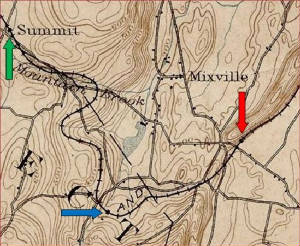
|

|

|
Phil Wooding Collection
EAST SUMMIT [M&W, 1888]
This station was in the eastern part of CHESHIRE. The arrows on the 1893 topo map at left show the locations of the WEST CHESHIRE (red), PROSPECT (blue), and SUMMIT (green) stations. The location for PROSPECT is incorrect: see P stations. The style of this shelter seems to duplicate the ones at CHESHIRE STREET, SOUTHINGTON ROAD, and WEST CHESHIRE. The renaming of this stop as EAST SUMMIT from the original SUMMIT, possibly due to the ICC order of 1915, is reflected in the signboard. The photo at right shows a consist by the water tank at this station. The trestle pictured at lower left was east of this station. The bridge is for Notch Rd; the embankment east of Notch Rd. is still visible today where the removal of the earthen fill left it to slope fairly abruptly down to the road. The train is heading for Plank Rd. and on to SUMMIT station. [rev11/16/16]
This station was in the eastern part of CHESHIRE. The arrows on the 1893 topo map at left show the locations of the WEST CHESHIRE (red), PROSPECT (blue), and SUMMIT (green) stations. The location for PROSPECT is incorrect: see P stations. The style of this shelter seems to duplicate the ones at CHESHIRE STREET, SOUTHINGTON ROAD, and WEST CHESHIRE. The renaming of this stop as EAST SUMMIT from the original SUMMIT, possibly due to the ICC order of 1915, is reflected in the signboard. The photo at right shows a consist by the water tank at this station. The trestle pictured at lower left was east of this station. The bridge is for Notch Rd; the embankment east of Notch Rd. is still visible today where the removal of the earthen fill left it to slope fairly abruptly down to the road. The train is heading for Plank Rd. and on to SUMMIT station. [rev11/16/16]
|
|

|
EAST THOMPSON1 [B&NYC, 1854]
This stop in the town of Thompson was established by the Boston & New York Central when they opened to a junction with the N&W at Mechanicsville in 1854. The first depot location is seen on the 1856WC map at [3] and is portrayed similarly on the 1867 Beers map in our files. It was east of the crossing of today's East Thompson Rd. where the former overpass saw the historic, four-train wreck of 12/4/1891. The two-story building at [1] corresponds to the map location of EAST THOMPSON1. Tom Chase, curator of the Ramsdell Transportation Collection in Thompson, CT, has extracted it from the accident photo at [2], which was colorized by Al Weaver to sharpen details; the sign appears to read 'Groceries.' Many early railroad stations were in commercial buildings like hotels and general stores where the store owner was also the station agent and sometimes the postmaster as well. By the time of the accident, EAST THOMPSON2 had been built west of here. [rev072614, 032219, 103121]
This stop in the town of Thompson was established by the Boston & New York Central when they opened to a junction with the N&W at Mechanicsville in 1854. The first depot location is seen on the 1856WC map at [3] and is portrayed similarly on the 1867 Beers map in our files. It was east of the crossing of today's East Thompson Rd. where the former overpass saw the historic, four-train wreck of 12/4/1891. The two-story building at [1] corresponds to the map location of EAST THOMPSON1. Tom Chase, curator of the Ramsdell Transportation Collection in Thompson, CT, has extracted it from the accident photo at [2], which was colorized by Al Weaver to sharpen details; the sign appears to read 'Groceries.' Many early railroad stations were in commercial buildings like hotels and general stores where the store owner was also the station agent and sometimes the postmaster as well. By the time of the accident, EAST THOMPSON2 had been built west of here. [rev072614, 032219, 103121]
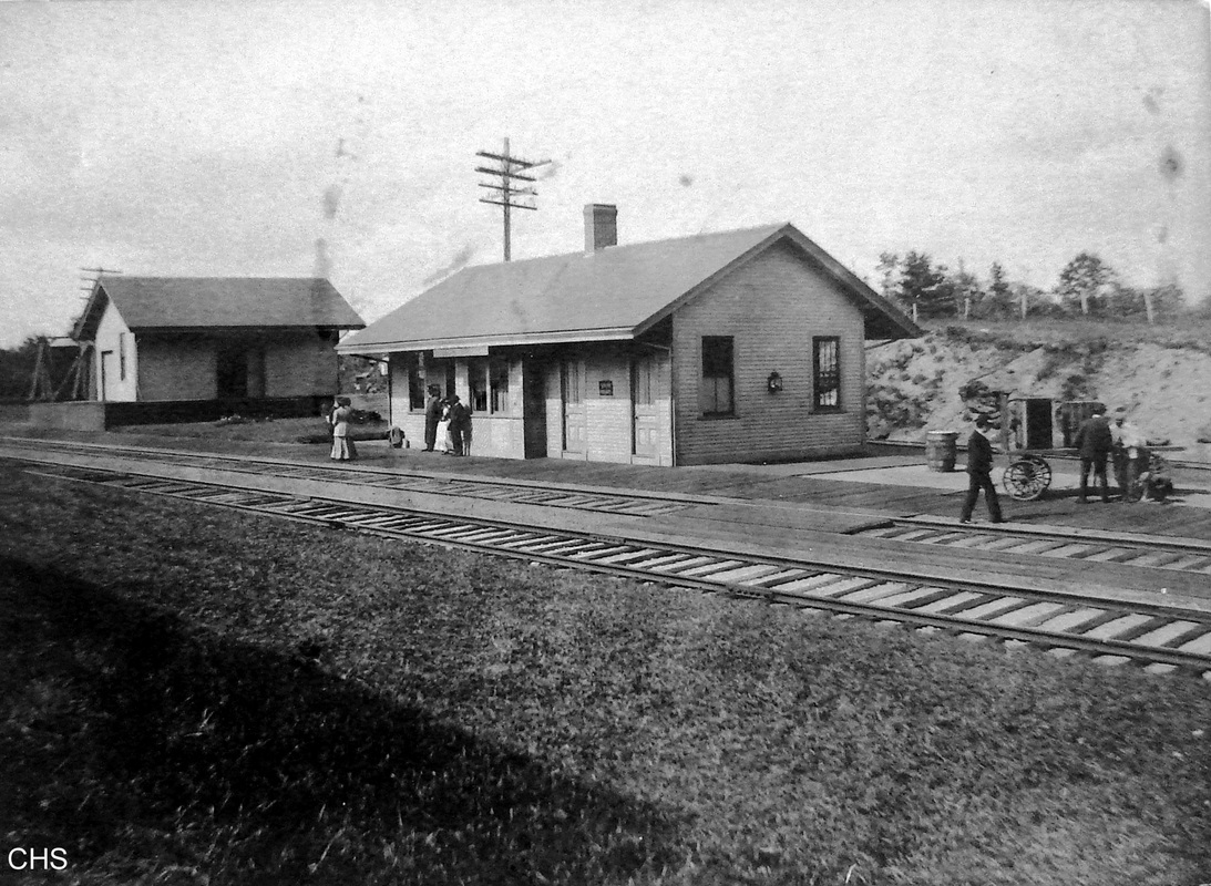
|

|

|
EAST THOMPSON2 [NY&NE, c1875]
This presumably is the depot that burned late in 1899 when the Register reported: "Railroad Station, Engine House and Signal Tower Burned Down. The railroad station at East Thompson, Conn., on the main line, Midland division of the Consolidated Road, together with the engine house, signal tower and contents of ticket and freight offices, were destroyed by fire yesterday morning [11/6/1899]. The loss was $1000, which was covered by insurance. The fire will cause a deal of inconvenience to the railroad people, as East Thompson is a junction point, the branch to Webster and Southbridge connecting with the main line there, and the destruction of the engine house, station, etc., will cramp the railroad in the handling of freight business and passenger traffic. S.H. Storms is station agent. When he left the station Sunday night everything was all right. The cause of the fire is unknown. The watchman at the engine house and the night telegraph operator knew nothing of the existence of the blaze until flames burst from all portions of the station." The mention of the signal station is interesting because towers on the Consolidated's New York Division dated back to 1888. The NY&NE was slow in implementing this new technology. Two years after the 12/4/1891 wreck, this one, according to the Worcester Daily Spy, was built in 1893 by contractor George S. Corbin to control train movements at the junction. Unless it was manned 24 hours a day, it probably would not have forestalled the 1891 wreck which occurred around 6:45 in the morning. The structure is described as a 12x15-foot 'tower' but no height measurement is given, so it likely looked like the successor cabin seen in the next entry. The photo at [1] either predates the construction of the 1893 tower building or it is out of sight to the right. We think the other photos, for reasons given in the next entry, also show EAST THOMPSON2 as well as the first signal station behind it. The ca. 1915 date on the photo at [3] would therefore have to be incorrect. [REFS: WDS/10/06/1893/05; NYNEAR18.1894.8; NHER/11/07/1899/01; NYHT/11/07/1899/01][rev052918, 032019, 090619, 112023]
This presumably is the depot that burned late in 1899 when the Register reported: "Railroad Station, Engine House and Signal Tower Burned Down. The railroad station at East Thompson, Conn., on the main line, Midland division of the Consolidated Road, together with the engine house, signal tower and contents of ticket and freight offices, were destroyed by fire yesterday morning [11/6/1899]. The loss was $1000, which was covered by insurance. The fire will cause a deal of inconvenience to the railroad people, as East Thompson is a junction point, the branch to Webster and Southbridge connecting with the main line there, and the destruction of the engine house, station, etc., will cramp the railroad in the handling of freight business and passenger traffic. S.H. Storms is station agent. When he left the station Sunday night everything was all right. The cause of the fire is unknown. The watchman at the engine house and the night telegraph operator knew nothing of the existence of the blaze until flames burst from all portions of the station." The mention of the signal station is interesting because towers on the Consolidated's New York Division dated back to 1888. The NY&NE was slow in implementing this new technology. Two years after the 12/4/1891 wreck, this one, according to the Worcester Daily Spy, was built in 1893 by contractor George S. Corbin to control train movements at the junction. Unless it was manned 24 hours a day, it probably would not have forestalled the 1891 wreck which occurred around 6:45 in the morning. The structure is described as a 12x15-foot 'tower' but no height measurement is given, so it likely looked like the successor cabin seen in the next entry. The photo at [1] either predates the construction of the 1893 tower building or it is out of sight to the right. We think the other photos, for reasons given in the next entry, also show EAST THOMPSON2 as well as the first signal station behind it. The ca. 1915 date on the photo at [3] would therefore have to be incorrect. [REFS: WDS/10/06/1893/05; NYNEAR18.1894.8; NHER/11/07/1899/01; NYHT/11/07/1899/01][rev052918, 032019, 090619, 112023]
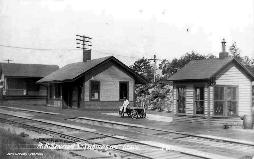
|
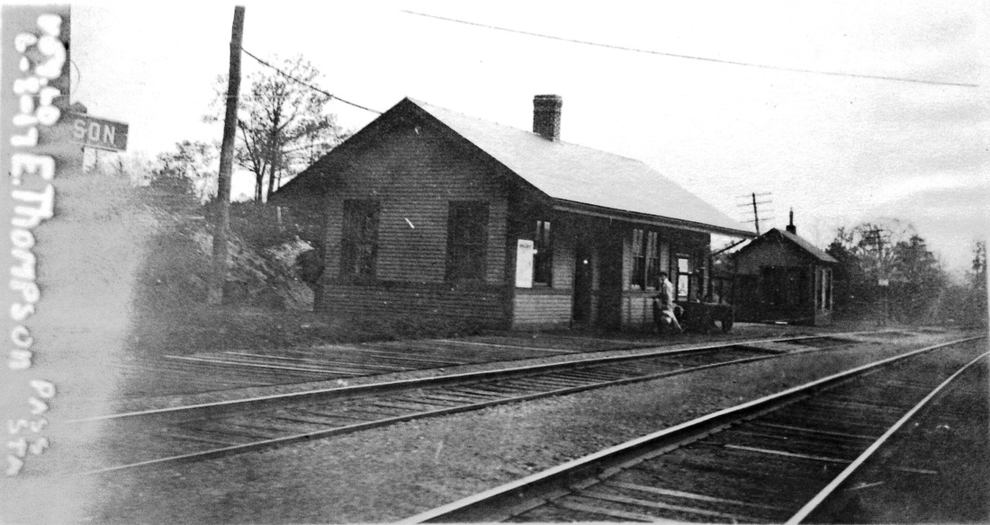
|
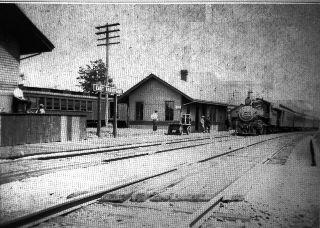
|
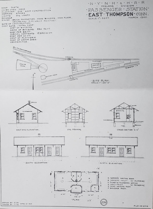 Al Lawrence Collection
EAST THOMPSON3 [NYNH&H, 1900]
The third station is seen here in the shots above. Though very similar to its predecessor, it has differences in the roof overhang and the windows, the wainscoting that was not in evidence on the earlier structure, and the absence of the signboard which we can see in the other two photos has now been placed on posts. The ICC valuation shot at [2] is dated 6/8/1917. The new structure housing SS 228 A.U. stands to just to the east. The shot at [3] is from the 1910s because the locomotive on the westbound main line train does not have the electric headlight mandated by federal law in 1920. The Southbridge local is on the branch track behind the depot. Although no mention has been found in the newspapers or in the annual reports of the railroad or the state commissioners, the architectural drawing at [4] is dated March, 1900 and the station was probably built by the middle of that year. This copy of the plan was found in the papers of the late Ed Sweeney of Norwood, MA and supplied to us by long-time TCS contributor Richard Fleischer of Newton Centre, MA. This station still appears on the 1934 aerial map but probably was demolished in 1935, per a 1/3/1936 letter from Frank Chapman Leete of Guilford to railroad historian Frank Ramsdell of East Thompson. [rev052918; 103121, 112023]
The third station is seen here in the shots above. Though very similar to its predecessor, it has differences in the roof overhang and the windows, the wainscoting that was not in evidence on the earlier structure, and the absence of the signboard which we can see in the other two photos has now been placed on posts. The ICC valuation shot at [2] is dated 6/8/1917. The new structure housing SS 228 A.U. stands to just to the east. The shot at [3] is from the 1910s because the locomotive on the westbound main line train does not have the electric headlight mandated by federal law in 1920. The Southbridge local is on the branch track behind the depot. Although no mention has been found in the newspapers or in the annual reports of the railroad or the state commissioners, the architectural drawing at [4] is dated March, 1900 and the station was probably built by the middle of that year. This copy of the plan was found in the papers of the late Ed Sweeney of Norwood, MA and supplied to us by long-time TCS contributor Richard Fleischer of Newton Centre, MA. This station still appears on the 1934 aerial map but probably was demolished in 1935, per a 1/3/1936 letter from Frank Chapman Leete of Guilford to railroad historian Frank Ramsdell of East Thompson. [rev052918; 103121, 112023]
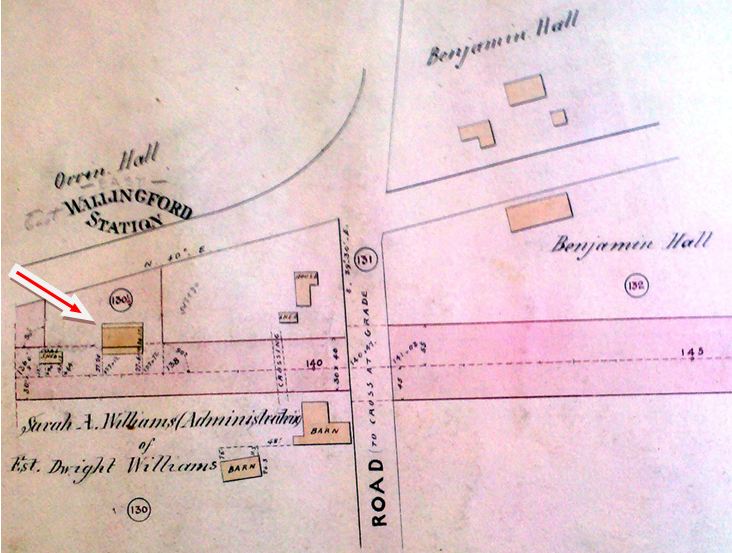
EAST WALLINGFORD1 [NHM&W, 1870]
This was established as the NHM&W's WALLINGFORD stop when the road opened in 1870. Track was constructed to this point in February, 1870 and there appears to have been a resident named Dwight Williams, likely the station agent, living in the depot by October, 1870, at which time the Courant said that the depot and siding were nearly complete. A newly discovered October, 1870 Register article adds considerably more detail as it says that "the Air Line depot building is being rapidly pushed forward by Mr. Coe, who has the job in hand. The roof is on and the floors will soon be laid so as to afford a shelter and standing place for passengers. Superintendent Waterbury has placed a gang of men at work making the side track complete, so that it can be used for a turn-out station.” The name of the stop was changed as of 11/1/1884 to EAST WALLINGFORD. This was after the 1882 NYNH&H lease of the then-B&NYAL and probably to distinguish it from the WALLINGFORD station on the Hartford line. We have no photo of EAST WALLINGFORD1 as of yet. A brief mention in Beckwith's Almanac tells us the fate of this first station, which it says burned on 6/5/1877 after it was "fired by lightning." Curiously, there is no mention otherwise in any newspaper or in the annual reports of the railroad commissioners or the NYNH&H. The multi-talented George Beckwith was a phonographer (early stenography), mathematics teacher, and surveyor whose maps of our namesake Tyler City are still used in the Orange town clerk's office today. He apparently digested newspapers from all over the state for his annual chronologies of New Haven and Connecticut events. Upon his death in 1880, the almanac was continued by his descendants until the 1930s and we will certainly be mining this useful source for other mentions of railroad stations. There is more about Beckwith on Track 1, MP 1.9 and 1.16. [REFS: CR/02/05/1870/03; CR/10/15/1870/04; HDC/10/28/1870/01; CR/10/29/1870/03; NHER/10/17/1884/04; BA32.1879.00][rev031613]
This was established as the NHM&W's WALLINGFORD stop when the road opened in 1870. Track was constructed to this point in February, 1870 and there appears to have been a resident named Dwight Williams, likely the station agent, living in the depot by October, 1870, at which time the Courant said that the depot and siding were nearly complete. A newly discovered October, 1870 Register article adds considerably more detail as it says that "the Air Line depot building is being rapidly pushed forward by Mr. Coe, who has the job in hand. The roof is on and the floors will soon be laid so as to afford a shelter and standing place for passengers. Superintendent Waterbury has placed a gang of men at work making the side track complete, so that it can be used for a turn-out station.” The name of the stop was changed as of 11/1/1884 to EAST WALLINGFORD. This was after the 1882 NYNH&H lease of the then-B&NYAL and probably to distinguish it from the WALLINGFORD station on the Hartford line. We have no photo of EAST WALLINGFORD1 as of yet. A brief mention in Beckwith's Almanac tells us the fate of this first station, which it says burned on 6/5/1877 after it was "fired by lightning." Curiously, there is no mention otherwise in any newspaper or in the annual reports of the railroad commissioners or the NYNH&H. The multi-talented George Beckwith was a phonographer (early stenography), mathematics teacher, and surveyor whose maps of our namesake Tyler City are still used in the Orange town clerk's office today. He apparently digested newspapers from all over the state for his annual chronologies of New Haven and Connecticut events. Upon his death in 1880, the almanac was continued by his descendants until the 1930s and we will certainly be mining this useful source for other mentions of railroad stations. There is more about Beckwith on Track 1, MP 1.9 and 1.16. [REFS: CR/02/05/1870/03; CR/10/15/1870/04; HDC/10/28/1870/01; CR/10/29/1870/03; NHER/10/17/1884/04; BA32.1879.00][rev031613]

EAST WALLINGFORD2 [B&NYAL, 1877]
Another singular mention in Beckwith's Almanac says this second station also burned, the 6/13/1901 fire causing a loss valued at $2,000. Curiously, there is no mention otherwise in any newspaper or in the annual reports of the railroad commissioners or the NYNH&H. This photo has a 1900 date on it and, if correct, it would show the second station. While very similar to the next one, we note differences in the freight door area, the width and depth of the agent's bay, the ground-level framing and possibly the signal mast and platform. [REFS: BA55.1902.72][rev031613]
Another singular mention in Beckwith's Almanac says this second station also burned, the 6/13/1901 fire causing a loss valued at $2,000. Curiously, there is no mention otherwise in any newspaper or in the annual reports of the railroad commissioners or the NYNH&H. This photo has a 1900 date on it and, if correct, it would show the second station. While very similar to the next one, we note differences in the freight door area, the width and depth of the agent's bay, the ground-level framing and possibly the signal mast and platform. [REFS: BA55.1902.72][rev031613]
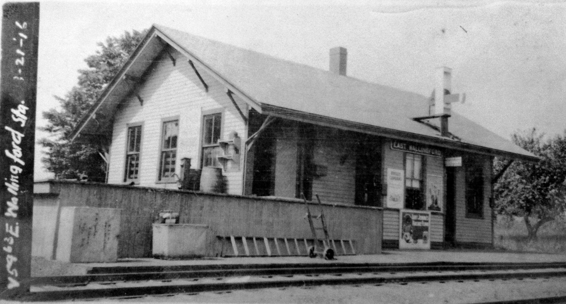
ICC Collection / National Archives
|
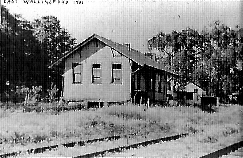
|
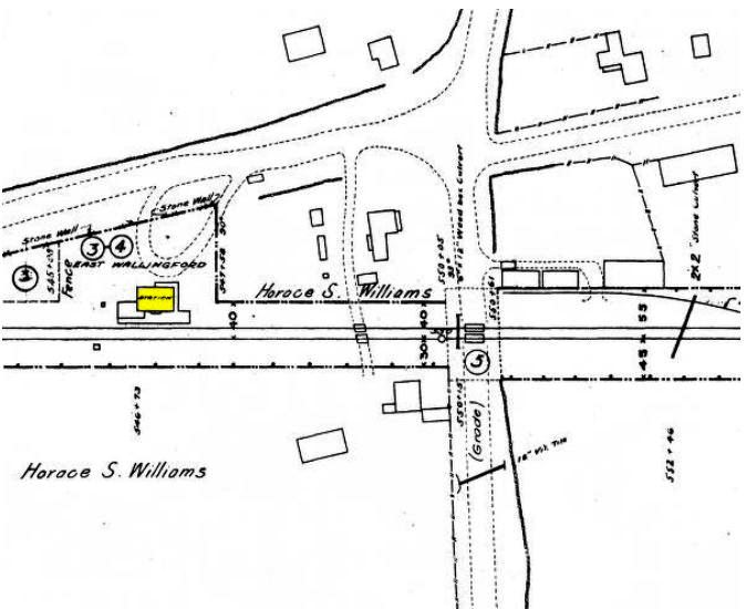
|

|
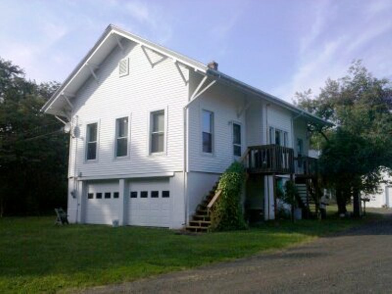
Courtesy of The Williams Family
|
EAST WALLINGFORD3 [NYNH&H, 1901]
Based on the Beckwith's Almanac information that the second station burned in June, 1901, we have revised the date for this third station to be late 1901. The val photo at upper left is dated 3/21/1916 and the shot at upper right says 1932. The 1915 val map at lower left shows the footprint of the third station looking to be in the same spot as the earlier ones. This depot still stands today, set back from the track and perched on a first-story foundation as a private home on East Center St. It is seen in the 1958 photo at lower middle and the lower right photo on 8/2/2010. [rev031713]
Based on the Beckwith's Almanac information that the second station burned in June, 1901, we have revised the date for this third station to be late 1901. The val photo at upper left is dated 3/21/1916 and the shot at upper right says 1932. The 1915 val map at lower left shows the footprint of the third station looking to be in the same spot as the earlier ones. This depot still stands today, set back from the track and perched on a first-story foundation as a private home on East Center St. It is seen in the 1958 photo at lower middle and the lower right photo on 8/2/2010. [rev031713]
EAST WATERVILLE [> WATERVILLE/E]
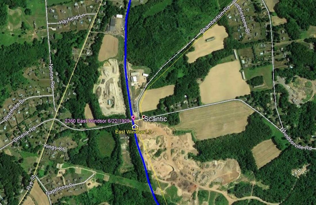
EAST WINDSOR1 [CC, 1876, opened as OSBORN?]
This was an original stop on the Connecticut Central RR which began operations in 1876 as an adjunct to the CV and thus provided service from Springfield through to Fenwick via Hartford Union Station. It was first seen on timetables as OSBORN. A May, 1877 article says: “The citizens of Windsorville are soon to have a fine depot and telegraph office at the flag station at Osborn, on the Connecticut Central railroad. These desirable objects are attained through the energy of Mr. St. Clair, agent of the woolen mill at Windsorville.” This appears to be another case of stations being built by private citizens and businessmen to encourage trains to stop at a particular town or village. We have no photograph of this first station. The snippet from our Track 11 Google Earth map shows the location of the EAST WINDSOR stations. [REFS: HDC/12/23/1875/01; MC/03/08/1876/02; HDC/03/25/1876/01: East Windsor station opened on 4/3/1876?; HDC/05/16/1877/04][rev120913, 121618, 122022]
This was an original stop on the Connecticut Central RR which began operations in 1876 as an adjunct to the CV and thus provided service from Springfield through to Fenwick via Hartford Union Station. It was first seen on timetables as OSBORN. A May, 1877 article says: “The citizens of Windsorville are soon to have a fine depot and telegraph office at the flag station at Osborn, on the Connecticut Central railroad. These desirable objects are attained through the energy of Mr. St. Clair, agent of the woolen mill at Windsorville.” This appears to be another case of stations being built by private citizens and businessmen to encourage trains to stop at a particular town or village. We have no photograph of this first station. The snippet from our Track 11 Google Earth map shows the location of the EAST WINDSOR stations. [REFS: HDC/12/23/1875/01; MC/03/08/1876/02; HDC/03/25/1876/01: East Windsor station opened on 4/3/1876?; HDC/05/16/1877/04][rev120913, 121618, 122022]

|
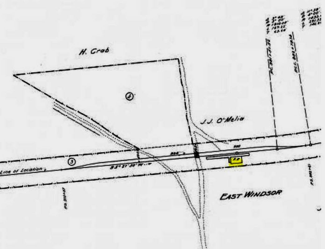
|

|
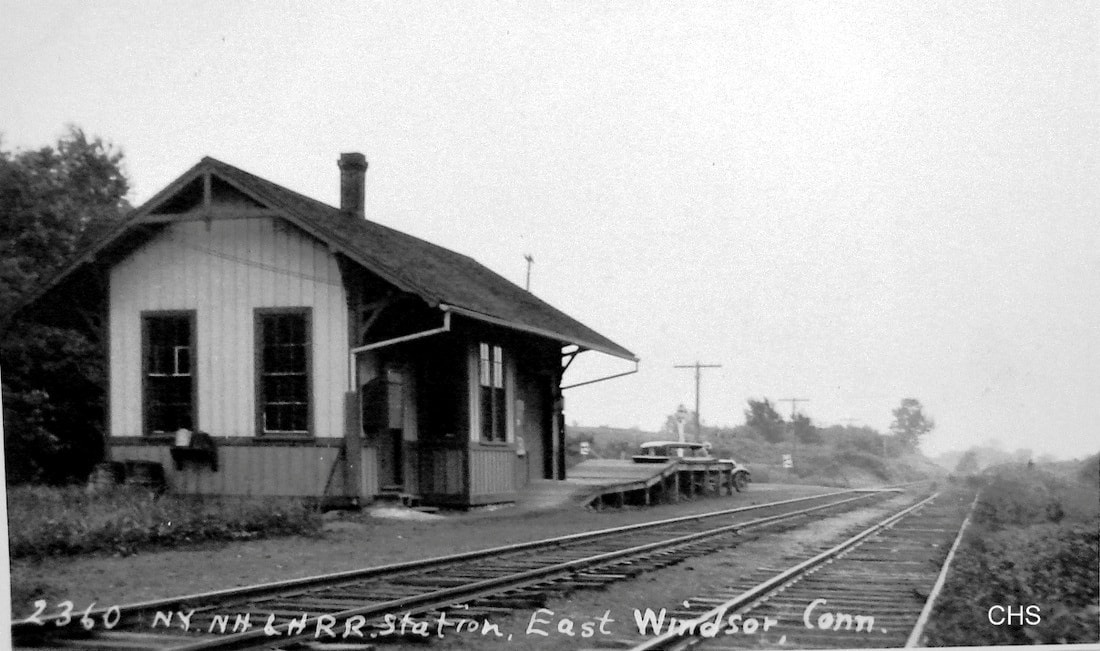
|
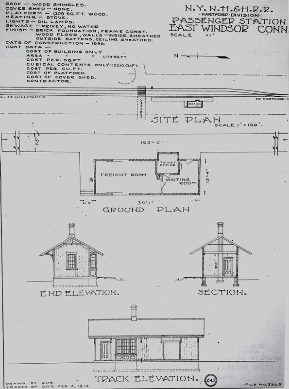
Al Lawrence Collection
; HC/06/25/1896/05; CRC45.1897.23]EAST WINDSOR2 [NYNH&H, 1897]
The image at [1] dates to the early 1900s; we have a post card of this view date-stamped 7/25/1912. The Courant reported in June, 1896 that the station had been renamed EAST WINDSOR and the railroad commissioners tell us that a new depot was built in 1897 after the first one burned. The 1915 val map at [2] shows the layout at that time. The new station is on the west side of the track, so the direction to the left on the map is toward Springfield. The ICC valuation photo at [3] is dated 8/7/1916. The fact that there are two windows on one end and a single window on the other is not unusual and has been seen elsewhere. The shot at [4] is Lewis H. Benton's #2360 from June, 1929; companion Drake is slouching by his sedan beyond the freight platform. The 2/3/1914 tracing at [5] is the architectural diagram which shows the dimensions of the structure, construction details, etc. This last image was copied from the papers of the late Ed Sweeney of Norwood, MA and forwarded to us by long-time TCS contributor Richard Fleischer of Newton Centre, MA. The 1938 SSRR list shows this station sold to Edward O'Brien for $25 on 9/6/1939. [REFS:; HC/06/25/1896/05; CRC45.1897.23][rev010318, 121618, 122022]
The image at [1] dates to the early 1900s; we have a post card of this view date-stamped 7/25/1912. The Courant reported in June, 1896 that the station had been renamed EAST WINDSOR and the railroad commissioners tell us that a new depot was built in 1897 after the first one burned. The 1915 val map at [2] shows the layout at that time. The new station is on the west side of the track, so the direction to the left on the map is toward Springfield. The ICC valuation photo at [3] is dated 8/7/1916. The fact that there are two windows on one end and a single window on the other is not unusual and has been seen elsewhere. The shot at [4] is Lewis H. Benton's #2360 from June, 1929; companion Drake is slouching by his sedan beyond the freight platform. The 2/3/1914 tracing at [5] is the architectural diagram which shows the dimensions of the structure, construction details, etc. This last image was copied from the papers of the late Ed Sweeney of Norwood, MA and forwarded to us by long-time TCS contributor Richard Fleischer of Newton Centre, MA. The 1938 SSRR list shows this station sold to Edward O'Brien for $25 on 9/6/1939. [REFS:; HC/06/25/1896/05; CRC45.1897.23][rev010318, 121618, 122022]

|

|

|
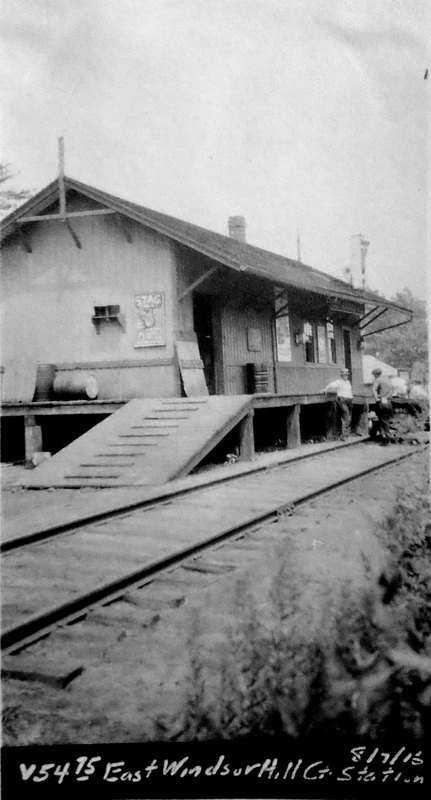
EAST WINDSOR HILL [CC, 1876]
This station was in the town of South Windsor. The upper left photo is a Benton and Drake from ca. 1930 and the shot at upper middle shows a Brill car doing the passenger honors on the line probably in the 1920s when service was down to one daily train each way. The 1915 val map shows the station in the southwest quadrant at the crossing where we have it highlighted in yellow. The buildings along the siding that ran to the east of the station are seen on the val map and in the upper left photo. The val photo at lower left is dated 8/17/1916. The 1938 SSRR list has this station sold to J. Ahearn for $100 on 10/27/1937. [REFS: HC/06/07/1912/04][rev010318]
This station was in the town of South Windsor. The upper left photo is a Benton and Drake from ca. 1930 and the shot at upper middle shows a Brill car doing the passenger honors on the line probably in the 1920s when service was down to one daily train each way. The 1915 val map shows the station in the southwest quadrant at the crossing where we have it highlighted in yellow. The buildings along the siding that ran to the east of the station are seen on the val map and in the upper left photo. The val photo at lower left is dated 8/17/1916. The 1938 SSRR list has this station sold to J. Ahearn for $100 on 10/27/1937. [REFS: HC/06/07/1912/04][rev010318]
EAST WINSTED [> WINSTED/C1]
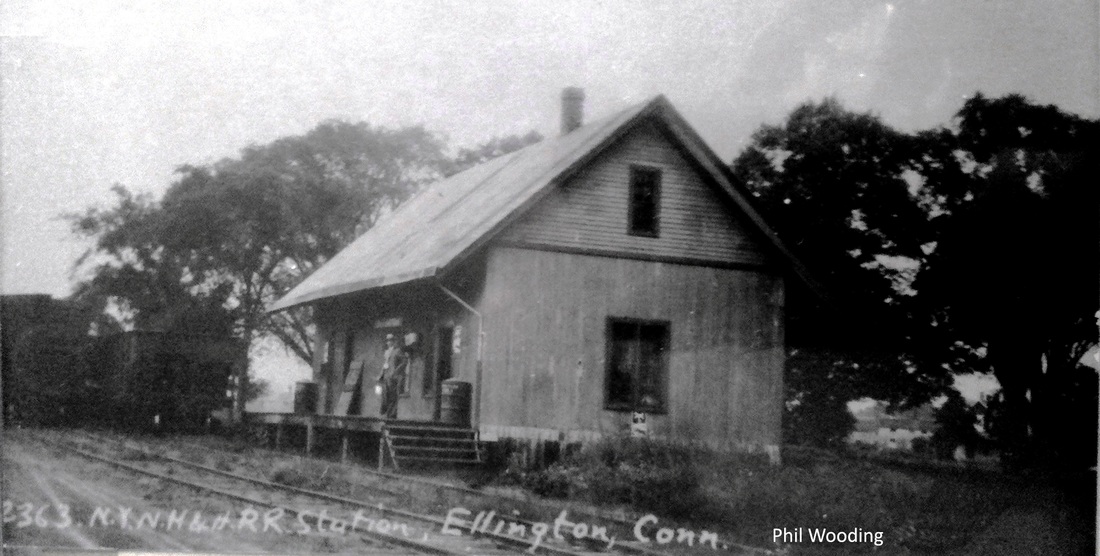
|

|
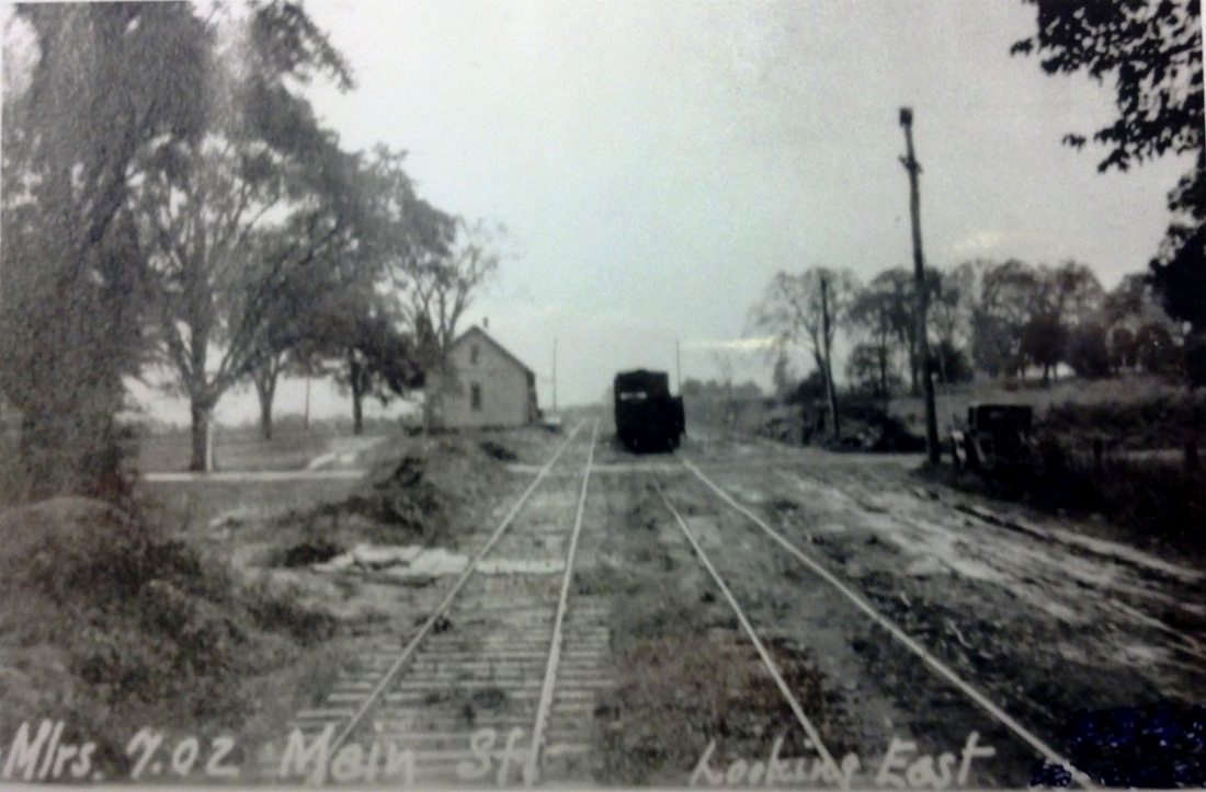
|
 National Archives
ELLINGTON [CC, 1876]
This stop opened late in 1876 when the branch from MELROSE was built by the CC to connect with the Rockville RR at WESTWAY. The Lewis H. Benton photo #2363 at [1] was taken in 1929, likely in late June; Irving Drake may be the person the platform but his sedan is nowhere to be seen in this particular shot. The real estate map at [2] shows the layout in 1888, with today's Frog Hollow Rd. then called Main St. The eastward-looking PUC photo at [3] dates to 10/20/1927 and shows the station standing ahead on the left (north) side of the track. The valuation shot at [4] was taken on 8/7/1916. Passenger service on the branch lasted until ca. 1927 but, as early as 1921, the NYNH&H had tried to eliminate the freight agency here as well, acquiescing finally to local objections that the closure would adversely affect ROCKVILLE. By 1962, with SADDS MILL and WINDERMERE long gone, ELLINGTON was the only stop left on the branch. The ICC examiner initially refused to allow it to be closed, siding with town officials who criticized the attitude of the NYNH&H railroad as "one of disinterest, indifference and lack of knowledge of the needs and conditions in the area." The ICC allowed the closure in spite of the town's request for two years to spur industrial development and Superior Propane Gas Co.'s testimony that it would have taken a minimum of a 100 10,000-gallon tank cars annually. [REFS: HDC/07/29/1876/04; HC/04/08/1921/11; SR/01/15/1937/17; HC/04/22/1962 /06A; HC/07/28/1962/02][rev021114]
This stop opened late in 1876 when the branch from MELROSE was built by the CC to connect with the Rockville RR at WESTWAY. The Lewis H. Benton photo #2363 at [1] was taken in 1929, likely in late June; Irving Drake may be the person the platform but his sedan is nowhere to be seen in this particular shot. The real estate map at [2] shows the layout in 1888, with today's Frog Hollow Rd. then called Main St. The eastward-looking PUC photo at [3] dates to 10/20/1927 and shows the station standing ahead on the left (north) side of the track. The valuation shot at [4] was taken on 8/7/1916. Passenger service on the branch lasted until ca. 1927 but, as early as 1921, the NYNH&H had tried to eliminate the freight agency here as well, acquiescing finally to local objections that the closure would adversely affect ROCKVILLE. By 1962, with SADDS MILL and WINDERMERE long gone, ELLINGTON was the only stop left on the branch. The ICC examiner initially refused to allow it to be closed, siding with town officials who criticized the attitude of the NYNH&H railroad as "one of disinterest, indifference and lack of knowledge of the needs and conditions in the area." The ICC allowed the closure in spite of the town's request for two years to spur industrial development and Superior Propane Gas Co.'s testimony that it would have taken a minimum of a 100 10,000-gallon tank cars annually. [REFS: HDC/07/29/1876/04; HC/04/08/1921/11; SR/01/15/1937/17; HC/04/22/1962 /06A; HC/07/28/1962/02][rev021114]
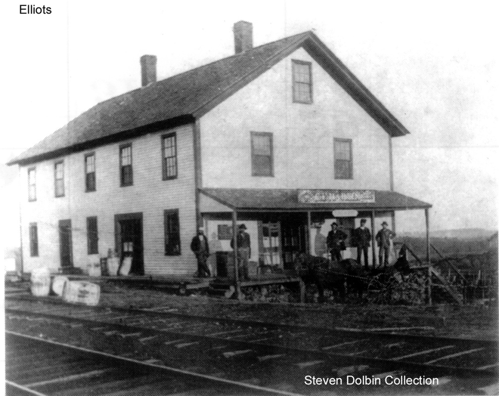
ELLIOTTS1 [BH&E, 1872; depot: NY&NE, 1877]
This stop was established in the town of Pomfret in 1872 when the BH&E opened the line from Putnam to Willimantic. Inasmuch as the railroad commissioners say in 1877 that a depot was proposed for this location, we do not know what, if anything more than a platform, preceded the one seen here. This fits the description which a 6/9/1891 Register article gave when it reported that "the railroad station and general store at Elliott's, Putnam, on the New England road, were destroyed by fire last night. The store was owned by C.F. Martin and the depot was in the same building. The fire originated from a spark from engine 144. The loss is $3,000. Insured." Although the wider reporting of news like this is impressive for the time, one has to be leery of the details. The Register makes a minor error in saying that the Elliotts stop was in Putnam when it was actually in the southwest corner of Pomfret. Moreover, the value of the property lost also varies from $1700 to $8,000! While three other sources report that the date of the fire was the 9th, we are sticking with the Register as having the earliest and most likely the correct date, the night of the 8th. That dating is echoed by the maternal granddaughter of Ira Elliott who gifted the land to the railroad on condition that it establish a station named ELLIOTTS. Many thanks to Pomfret town historian Walter Hinchman for providing the Holbrook letter and other details about Pomfret's railroad history. [REFS: RRL/NY&NE (5/9/1877); CRC25.1878.36; NHER/06/09/1891/04; BA45.1892.88; BDA/06/10/1891/01; SR/06/10/1891/07; Abbie S. Holbrook letter 10/23/1945][rev020712, 031920]
This stop was established in the town of Pomfret in 1872 when the BH&E opened the line from Putnam to Willimantic. Inasmuch as the railroad commissioners say in 1877 that a depot was proposed for this location, we do not know what, if anything more than a platform, preceded the one seen here. This fits the description which a 6/9/1891 Register article gave when it reported that "the railroad station and general store at Elliott's, Putnam, on the New England road, were destroyed by fire last night. The store was owned by C.F. Martin and the depot was in the same building. The fire originated from a spark from engine 144. The loss is $3,000. Insured." Although the wider reporting of news like this is impressive for the time, one has to be leery of the details. The Register makes a minor error in saying that the Elliotts stop was in Putnam when it was actually in the southwest corner of Pomfret. Moreover, the value of the property lost also varies from $1700 to $8,000! While three other sources report that the date of the fire was the 9th, we are sticking with the Register as having the earliest and most likely the correct date, the night of the 8th. That dating is echoed by the maternal granddaughter of Ira Elliott who gifted the land to the railroad on condition that it establish a station named ELLIOTTS. Many thanks to Pomfret town historian Walter Hinchman for providing the Holbrook letter and other details about Pomfret's railroad history. [REFS: RRL/NY&NE (5/9/1877); CRC25.1878.36; NHER/06/09/1891/04; BA45.1892.88; BDA/06/10/1891/01; SR/06/10/1891/07; Abbie S. Holbrook letter 10/23/1945][rev020712, 031920]

|
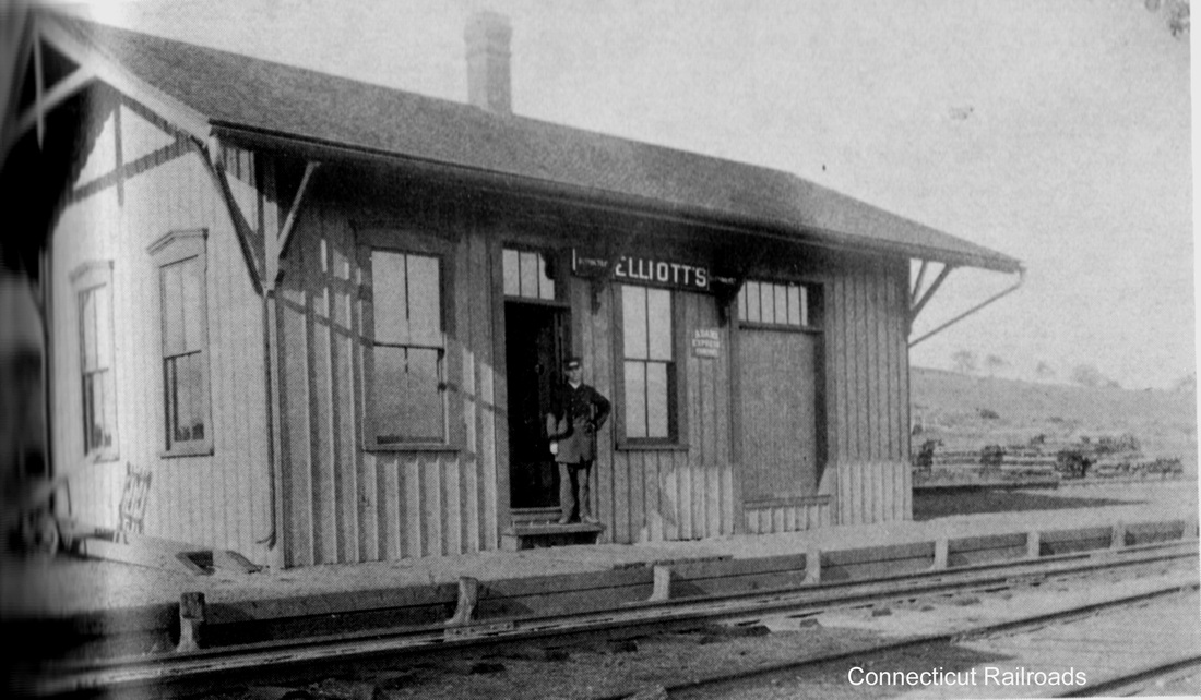
|
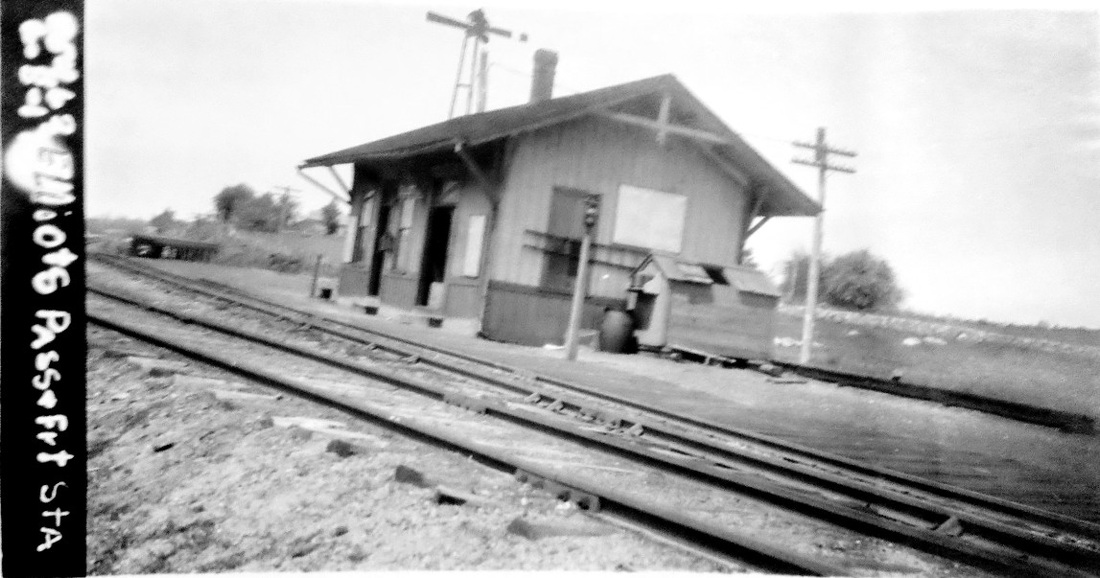
|
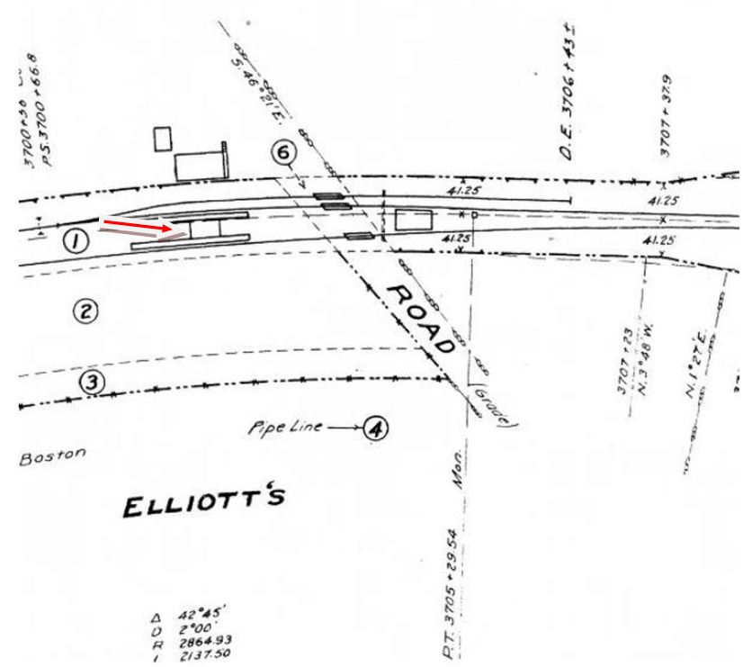
ELLIOTTS2 [NY&NE, 1891]
The second station is seen above, the photo on the left also showing what must be the rebuilt general store, now without the depot entrance seen in the photo at ELLIOTTS1. We have assigned the 1891 build date for the new station based on the June 9 burning of the old one and assuming the new depot was up by the end of the year. Nothing is said by the railroad commissioners, newspapers, or the NY&NE annual reports on the new station, although we will recheck the latter at the Peters Railroad Museum on our next visit. The 1915 val map shows the depot at the red arrow, flanked by long platforms and tracks on both sides. The rebuilt store is seen above the depot. The 1938 SSRR list has this station sold to P. Smithard(?) for $20 presumably in 1938.[rev010318]
The second station is seen above, the photo on the left also showing what must be the rebuilt general store, now without the depot entrance seen in the photo at ELLIOTTS1. We have assigned the 1891 build date for the new station based on the June 9 burning of the old one and assuming the new depot was up by the end of the year. Nothing is said by the railroad commissioners, newspapers, or the NY&NE annual reports on the new station, although we will recheck the latter at the Peters Railroad Museum on our next visit. The 1915 val map shows the depot at the red arrow, flanked by long platforms and tracks on both sides. The rebuilt store is seen above the depot. The 1938 SSRR list has this station sold to P. Smithard(?) for $20 presumably in 1938.[rev010318]
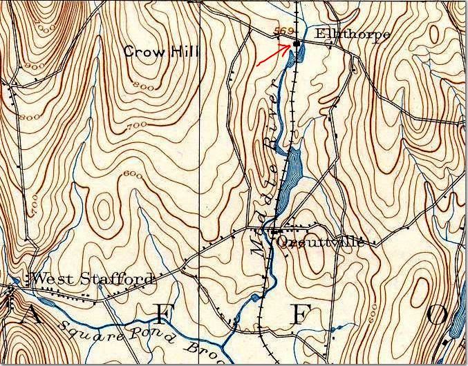
|
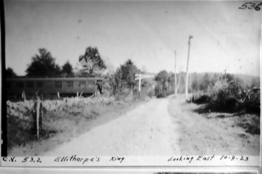
|
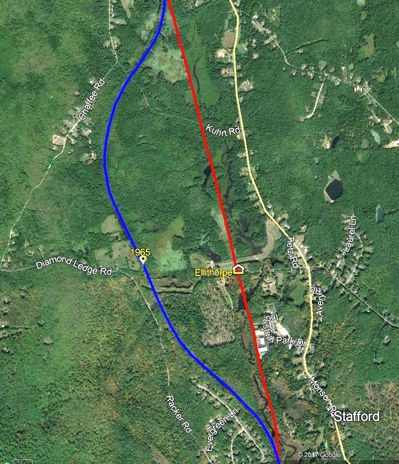
|
ELLITHORPE [NLN, 1850?]
This is an obscure station in the town of STAFFORD for which we have no photograph. Timetables and maps from 1859 to 1900 regularly show this stop but it is no longer listed on a CVT 1927TT. If we can count on the 1892 topo map at left for accuracy, the station stood at the road on the south side of the grade crossing. It is either out of view to the right in the eastward-looking 10/9/1923 PUC inspection photo or gone altogether by that time. This line was relocated to the west in 1965 as part of a flood control project on the Middle River after the hurricanes of 1955, as seen on the snippet at right. Our full Google Earth map is on Track 11. [REFS: HC/11/14/1958/30B][rev031213]
This is an obscure station in the town of STAFFORD for which we have no photograph. Timetables and maps from 1859 to 1900 regularly show this stop but it is no longer listed on a CVT 1927TT. If we can count on the 1892 topo map at left for accuracy, the station stood at the road on the south side of the grade crossing. It is either out of view to the right in the eastward-looking 10/9/1923 PUC inspection photo or gone altogether by that time. This line was relocated to the west in 1965 as part of a flood control project on the Middle River after the hurricanes of 1955, as seen on the snippet at right. Our full Google Earth map is on Track 11. [REFS: HC/11/14/1958/30B][rev031213]
|
|
ELMWOOD [HP&F, 1850]
This station in the town of West Hartford carried that name originally. The Courant said in 1874 that it was to be renamed ELMWOOD beginning June 1. The 1938 SSRR list has this station sold presumably in that year. [REFS: HDC/05/07/1874/02; HDC/02/10/1883/04][rev010318]
This station in the town of West Hartford carried that name originally. The Courant said in 1874 that it was to be renamed ELMWOOD beginning June 1. The 1938 SSRR list has this station sold presumably in that year. [REFS: HDC/05/07/1874/02; HDC/02/10/1883/04][rev010318]
ENFIELD [> THOMPSONVILLE3]
ENFIELD BRIDGE1 [H&NH, 1844]
This stop in the town of Enfield was established in 1844 when the H&NH opened its line from Hartford to Springfield. We think the freight house pictured in the 8/11/1916 val photo may be the first station here. [rev090319]
This stop in the town of Enfield was established in 1844 when the H&NH opened its line from Hartford to Springfield. We think the freight house pictured in the 8/11/1916 val photo may be the first station here. [rev090319]

|
Richard A. Fleischer Collection
|
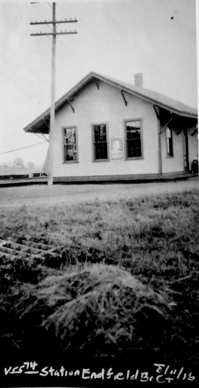
ENFIELD BRIDGE2 [NYNH&H, c1890?]
The second station is seen on the left in the photo at [1] and the freight depot is to the right of the tracks. The shot at [2] is Louis H. Benton #2357 taken in May or June of 1929. Fellow photographer Irving Drake is seen with his sedan that brought the duo all over New England for depot photos. He seems in awe of the approaching train #184 with engine 328 on the point, according to Benton's captioning. The val photo at [3] is dated 8/11/1916, the same as the one of the freight station in our previous entry. [REFS: CRC42.1894.18; HC/04/20/1896/09: bridge, closed as unsafe; HC/08/25/1900/12; HC/08/21/1901/07: bridge dynamited and removed][rev090319]
The second station is seen on the left in the photo at [1] and the freight depot is to the right of the tracks. The shot at [2] is Louis H. Benton #2357 taken in May or June of 1929. Fellow photographer Irving Drake is seen with his sedan that brought the duo all over New England for depot photos. He seems in awe of the approaching train #184 with engine 328 on the point, according to Benton's captioning. The val photo at [3] is dated 8/11/1916, the same as the one of the freight station in our previous entry. [REFS: CRC42.1894.18; HC/04/20/1896/09: bridge, closed as unsafe; HC/08/25/1900/12; HC/08/21/1901/07: bridge dynamited and removed][rev090319]

|

|
|
ESSEX1 [CV, 1871]
This station stood as shown on the 1874 Beers atlas of Middlesex County in the Centerbrook section of town. The stop was established in 1871 when the CV opened and passenger service ended in 1930 or 1931. The 1938 SSRR list has this station sold for $75.00 on 7/20/1938, faint handwriting may say to the Middletown Wrecking Co. [REFS: HDC/08/25/1871/02; K98; R51][rev011218]
This station stood as shown on the 1874 Beers atlas of Middlesex County in the Centerbrook section of town. The stop was established in 1871 when the CV opened and passenger service ended in 1930 or 1931. The 1938 SSRR list has this station sold for $75.00 on 7/20/1938, faint handwriting may say to the Middletown Wrecking Co. [REFS: HDC/08/25/1871/02; K98; R51][rev011218]

ESSEX2 [VRR, 1971]
According to Max Miller, the Essex freight house was built in 1892. It has been used by the Valley RR since 1971 as its passenger station. It is seen in the distance; view looks south. [REFS: ATVL35][rev011218]
According to Max Miller, the Essex freight house was built in 1892. It has been used by the Valley RR since 1971 as its passenger station. It is seen in the distance; view looks south. [REFS: ATVL35][rev011218]