Track 12: CT Passenger Stations, F
See TCS Home Page links for notes, abbreviations, and sources.
Use Track 11 map link to locate stations, rail and trolley lines, and POIs.
See TCS Home Page links for notes, abbreviations, and sources.
Use Track 11 map link to locate stations, rail and trolley lines, and POIs.

|

|
|
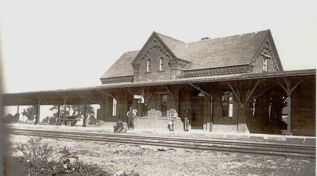
FAIR GROUNDS/NORWALK [D&N, 1868]
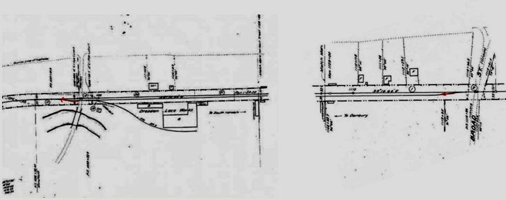
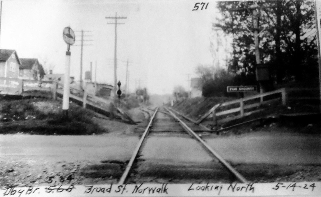
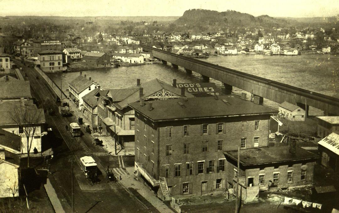
This newspapers refer to this stop in Norwalk as being about two miles north of South Norwalk. The Fairfield County Agricultural Society purchased land in the Winnipauk section of Norwalk in 1867 and began to hold the annual agricultural and livestock fair here instead of assigning the event to the highest-bidding town as was done previously. By 1870, the state agriculture commission [click here] was commending the D&N for its "excellent arrangements" and frequent service, "depositing passengers directly at the entrance to the grounds." Those grounds and that entrance are seen on the ca. 1876 E.B. Hyde map of Norwalk [upper left] at the red arrow and we wonder if someone has a photograph of the gateway building there that must also have served as the railroad station. In 1868 the arrivals even included 'the Brookfield car' brought down from Danbury where it was taken from the newly opened NYH&N: see Track 10, MP 10.2.0. Ironically, by 1889 the rival Danbury Fair overpowered the Norwalk event and the beleagured FCAS sold its land to a group that continued the operation of just the race track. The 1892 Norwalk city directory map [middle], which misspells WINNIPAUK, shows this area as the Gentlemen's Driving Park, correctly labeled as being now on the HRR, lessee of the D&N since 1886. The location is clarified in the two side by side val maps [click here and here]. The FAIR GROUNDS siding started just above Broad St., which is the road shown in the PUC photograph [lower left], and ended just above Perry Ave. No mention is made of the driving park or fair grounds on the 1915 val maps and we note that by then the Dresden Lace Mill, served by its own spur track, is now on part of the the old fair grounds property below Perry Ave. Cornwall says that this stop was still on employee timetables until the 1930s though passenger service, if it outlived the fair, undoubtedly ended with the driving park's demise in the early 1900s. [REFS: NYT/02/12/1880/02; NYT/08/08/1889/03; NHER/08/14/1889/04; HC/08/22/1889/01; NYT/09/28/1899/10; SL17.4.24][rev030813]
This newspapers refer to this stop in Norwalk as being about two miles north of South Norwalk. The Fairfield County Agricultural Society purchased land in the Winnipauk section of Norwalk in 1867 and began to hold the annual agricultural and livestock fair here instead of assigning the event to the highest-bidding town as was done previously. By 1870, the state agriculture commission [click here] was commending the D&N for its "excellent arrangements" and frequent service, "depositing passengers directly at the entrance to the grounds." Those grounds and that entrance are seen on the ca. 1876 E.B. Hyde map of Norwalk [upper left] at the red arrow and we wonder if someone has a photograph of the gateway building there that must also have served as the railroad station. In 1868 the arrivals even included 'the Brookfield car' brought down from Danbury where it was taken from the newly opened NYH&N: see Track 10, MP 10.2.0. Ironically, by 1889 the rival Danbury Fair overpowered the Norwalk event and the beleagured FCAS sold its land to a group that continued the operation of just the race track. The 1892 Norwalk city directory map [middle], which misspells WINNIPAUK, shows this area as the Gentlemen's Driving Park, correctly labeled as being now on the HRR, lessee of the D&N since 1886. The location is clarified in the two side by side val maps [click here and here]. The FAIR GROUNDS siding started just above Broad St., which is the road shown in the PUC photograph [lower left], and ended just above Perry Ave. No mention is made of the driving park or fair grounds on the 1915 val maps and we note that by then the Dresden Lace Mill, served by its own spur track, is now on part of the the old fair grounds property below Perry Ave. Cornwall says that this stop was still on employee timetables until the 1930s though passenger service, if it outlived the fair, undoubtedly ended with the driving park's demise in the early 1900s. [REFS: NYT/02/12/1880/02; NYT/08/08/1889/03; NHER/08/14/1889/04; HC/08/22/1889/01; NYT/09/28/1899/10; SL17.4.24][rev030813]

|
|
|
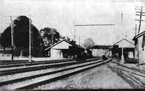
FAIR GROUNDS/DANBURY [NY&NE, 1881]
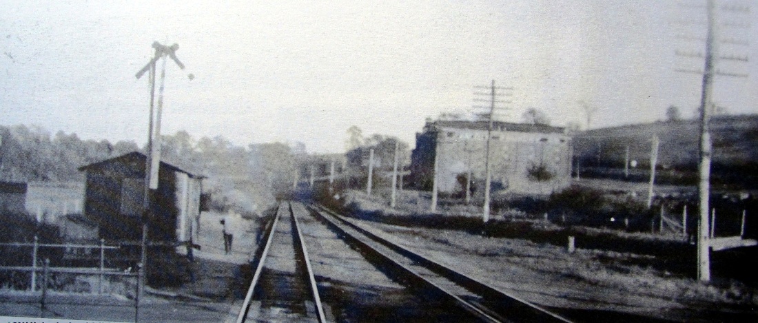
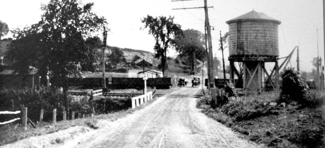
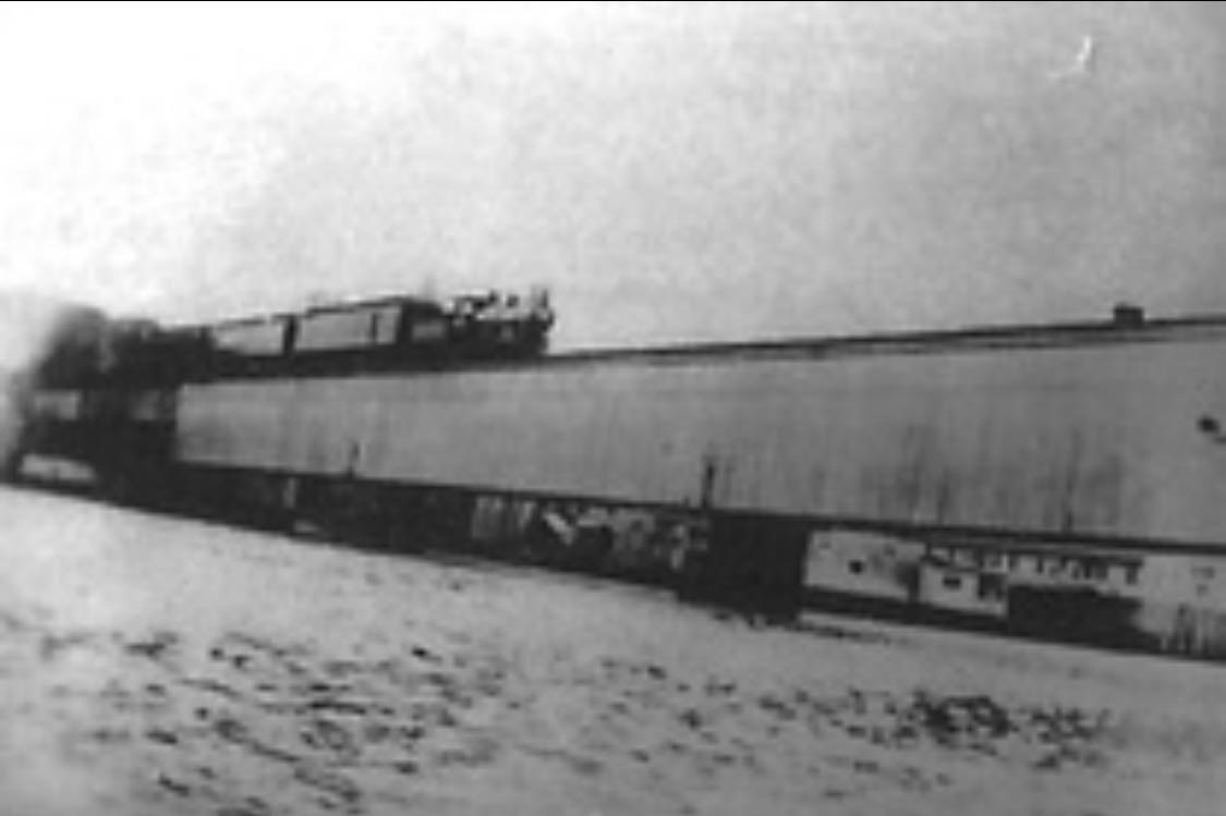
The opening of the NY&NE to New York state in the summer of 1881 was, among other impacts, a boon to the Danbury Fair. The newspaper said this would be a great convenience to patrons in the coming fall season. With trackage passing right by the grounds, the annual celebration of farming and related pursuits was more accessible and more competitive than ever before, shortly causing the demise of the FCAS event in Norwalk. There was just a platform here that saw use primarily for these events. The siding is seen in two of the photos, the left, which we think looks west, and the middle, therefore, looking east. The shot on the right probably looks south at the grade crossing by the entrance to the fair grounds. [REFS: DN/07/27/1881/08][rev100112]
The opening of the NY&NE to New York state in the summer of 1881 was, among other impacts, a boon to the Danbury Fair. The newspaper said this would be a great convenience to patrons in the coming fall season. With trackage passing right by the grounds, the annual celebration of farming and related pursuits was more accessible and more competitive than ever before, shortly causing the demise of the FCAS event in Norwalk. There was just a platform here that saw use primarily for these events. The siding is seen in two of the photos, the left, which we think looks west, and the middle, therefore, looking east. The shot on the right probably looks south at the grade crossing by the entrance to the fair grounds. [REFS: DN/07/27/1881/08][rev100112]

|
|
Alfred Frederick Bishop photo
|
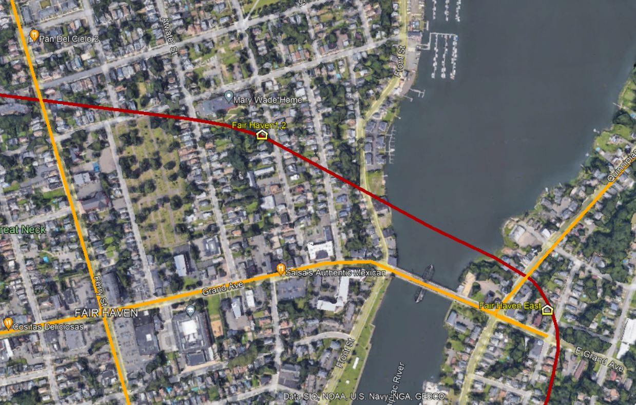
FAIR HAVEN1 [NH&NL, 1852]
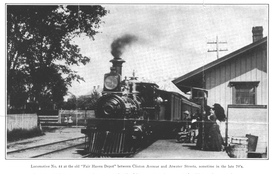
This station was located on Clinton Ave. in the eastern section of New Haven that lies between the Mill and Quinnipiac Rivers. This was the first stop after MILL RIVER JCT once the NH&NL began running from the Austin depot in 1852. The 1879 Bailey bird's-eye map snippet at [1] shows this station standing on the south side of the track. Richard Fleischer sent us a scanned page from a 1938 New Haven Tercentenary publication, which contained the photo at [2] over an article by NYNH&H electrical engineer and rail historian Sidney F. Withington. Notes on the page by antiquarian C.E.H. Whitlock say that the talented Albert Frederick Bishop of 95 Grand Ave. was probably the photographer and that members of his family are in the scene. Bishop was a talented inventor as well as an energetic photographer who chased trains and fire engines in his neighborhood. He is said to have been on good terms with locomotive crews who would lean out of the cab and pour on the steam for his shots. He would often have others pose as well, like the young lady with the parasol in the image at [3]. This station burned on 9/28/1892 after a kerosene lamp exploded. It was described at that time as a one-story frame building, about 50 feet long and valued at $2,000. At [4] the inimitable Al Weaver has superimposed another historic photo onto the more contemporary scene; the house at the right is still standing on the east side of Clinton Ave., now unfortunately minus the Victorian trim. [REFS: NHER/09/29/1892/03][rev011218, 050522]
This station was located on Clinton Ave. in the eastern section of New Haven that lies between the Mill and Quinnipiac Rivers. This was the first stop after MILL RIVER JCT once the NH&NL began running from the Austin depot in 1852. The 1879 Bailey bird's-eye map snippet at [1] shows this station standing on the south side of the track. Richard Fleischer sent us a scanned page from a 1938 New Haven Tercentenary publication, which contained the photo at [2] over an article by NYNH&H electrical engineer and rail historian Sidney F. Withington. Notes on the page by antiquarian C.E.H. Whitlock say that the talented Albert Frederick Bishop of 95 Grand Ave. was probably the photographer and that members of his family are in the scene. Bishop was a talented inventor as well as an energetic photographer who chased trains and fire engines in his neighborhood. He is said to have been on good terms with locomotive crews who would lean out of the cab and pour on the steam for his shots. He would often have others pose as well, like the young lady with the parasol in the image at [3]. This station burned on 9/28/1892 after a kerosene lamp exploded. It was described at that time as a one-story frame building, about 50 feet long and valued at $2,000. At [4] the inimitable Al Weaver has superimposed another historic photo onto the more contemporary scene; the house at the right is still standing on the east side of Clinton Ave., now unfortunately minus the Victorian trim. [REFS: NHER/09/29/1892/03][rev011218, 050522]
FAIR HAVEN2 [NYNH&H, 1893]
The newspaper said after FAIR HAVEN1 burned late in 1892 that a new station would be built in about a week near the site of the burned building on Clinton Ave. Impressive speed! The immediate attention was probably indicative of the heavy passenger traffic to and from downtown, This was to be comfortably fitted up but not meant to be permanent since the new Shore Line "cut off" was expected to be completed in about a year, at which time a station on the new line would open. A combination car was to be used here as a ticket office and waiting room in the meantime. FAIR HAVEN2 would be discontinued when FAIR HAVEN3 opened. We do not know the fate of this depot. The snippet from our Track 11 Google Earth map shows the site where both FAIR HAVEN1 and FAIR HAVEN2 stood. [REFS: NHER/09/29/1892/03; NHER/09/30/1892/01][rev050522]
The newspaper said after FAIR HAVEN1 burned late in 1892 that a new station would be built in about a week near the site of the burned building on Clinton Ave. Impressive speed! The immediate attention was probably indicative of the heavy passenger traffic to and from downtown, This was to be comfortably fitted up but not meant to be permanent since the new Shore Line "cut off" was expected to be completed in about a year, at which time a station on the new line would open. A combination car was to be used here as a ticket office and waiting room in the meantime. FAIR HAVEN2 would be discontinued when FAIR HAVEN3 opened. We do not know the fate of this depot. The snippet from our Track 11 Google Earth map shows the site where both FAIR HAVEN1 and FAIR HAVEN2 stood. [REFS: NHER/09/29/1892/03; NHER/09/30/1892/01][rev050522]
Dave Peters Collection
|

|
|
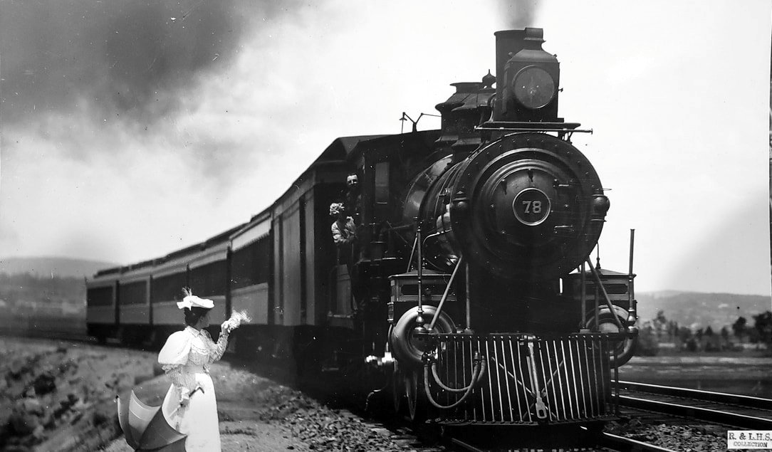
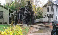
FAIR HAVEN3 [NYNH&H, 1894]
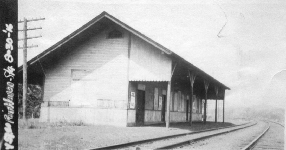
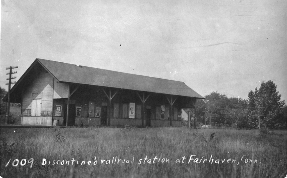
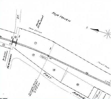
This new depot opened on 7/30/1894. The original speculation was that it would be built at the corner of Blatchley Ave. and State St., at the junction with the new double-tracked Shore Line and where it might have supplanted the CEDAR HILL station. A location at the southwest corner of Hemingway St. and First Ave. was chosen instead, as shown on the 1915 val map at [4]. The NYNH&H was already buying lots here in August of 1892. The 8/30/1916 valuation photo at [1] looks northwest. FAIR HAVEN3 was described as standard size for locations like this and about the same dimensions as the FAIR HAVEN2 station, the furnishings of which were to be transferred to the new building here. The period photo at [2] likely dates to the early 1900s. Is that the station agent standing at left? The New Haven Union newspaper reported in June, 1906 that the station "... has been closed on account of small patronage..." With the extension of trolley service into the Annex, as the portion of the city east of the of the Quinnipiac River is still called, people were said to prefer going to CEDAR HILL or Union Station to take the train. Lewis H. Benton shot his photo #1009, as seen at [3], likely on 8/27/1917, the same day that he dated his #1008 shot at CEDAR HILL. His image shows FAIR HAVEN3 to be a more substantial structure than was needed and verifies that it was already 'discontinued' for passenger service. Usually a stickler for spelling, Fairhaven is correct for Massachusetts but not for Connecticut. According to Leroy Roberts, FAIR HAVEN3 was destroyed by fire obviously some time after Benton's visit. [REFS: NHER/08/13/1892/01; NHER/11/30/1892/01; NHER/12/02/1892/04; NHER/01/13/1893/01; NHER/01/16/1894/01; NHER/07/17/1894/01; NHER/07/26/1894/04; NHER/07/28/1894/03; NHER/08/20/1894/04; NHU/06/02/1906/10][rev011218, 050522]
This new depot opened on 7/30/1894. The original speculation was that it would be built at the corner of Blatchley Ave. and State St., at the junction with the new double-tracked Shore Line and where it might have supplanted the CEDAR HILL station. A location at the southwest corner of Hemingway St. and First Ave. was chosen instead, as shown on the 1915 val map at [4]. The NYNH&H was already buying lots here in August of 1892. The 8/30/1916 valuation photo at [1] looks northwest. FAIR HAVEN3 was described as standard size for locations like this and about the same dimensions as the FAIR HAVEN2 station, the furnishings of which were to be transferred to the new building here. The period photo at [2] likely dates to the early 1900s. Is that the station agent standing at left? The New Haven Union newspaper reported in June, 1906 that the station "... has been closed on account of small patronage..." With the extension of trolley service into the Annex, as the portion of the city east of the of the Quinnipiac River is still called, people were said to prefer going to CEDAR HILL or Union Station to take the train. Lewis H. Benton shot his photo #1009, as seen at [3], likely on 8/27/1917, the same day that he dated his #1008 shot at CEDAR HILL. His image shows FAIR HAVEN3 to be a more substantial structure than was needed and verifies that it was already 'discontinued' for passenger service. Usually a stickler for spelling, Fairhaven is correct for Massachusetts but not for Connecticut. According to Leroy Roberts, FAIR HAVEN3 was destroyed by fire obviously some time after Benton's visit. [REFS: NHER/08/13/1892/01; NHER/11/30/1892/01; NHER/12/02/1892/04; NHER/01/13/1893/01; NHER/01/16/1894/01; NHER/07/17/1894/01; NHER/07/26/1894/04; NHER/07/28/1894/03; NHER/08/20/1894/04; NHU/06/02/1906/10][rev011218, 050522]
|

|
HAER photo
|
HAER photo
|
Roman Daniels photo
|
Roman Daniels photo
|
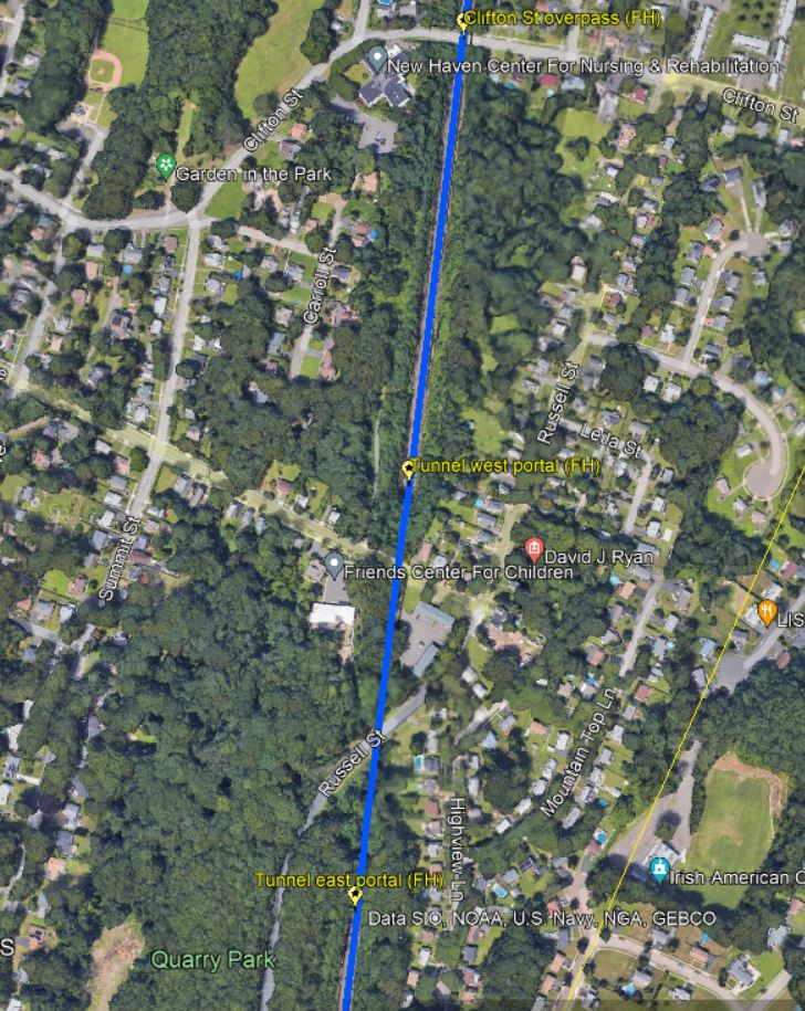
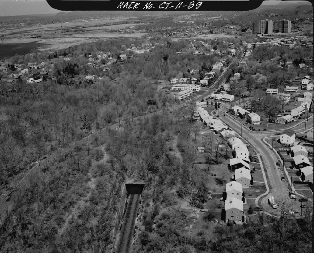
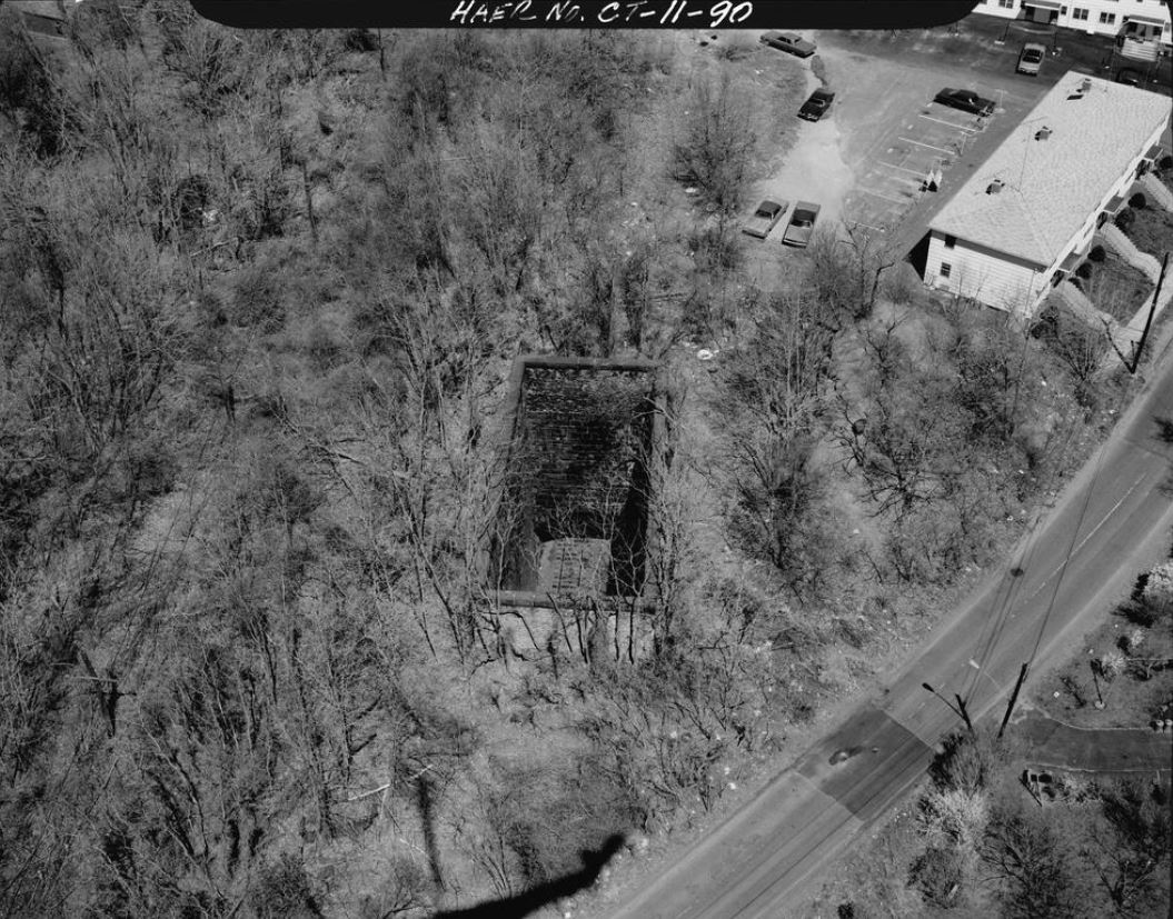
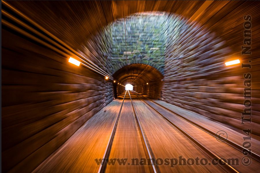
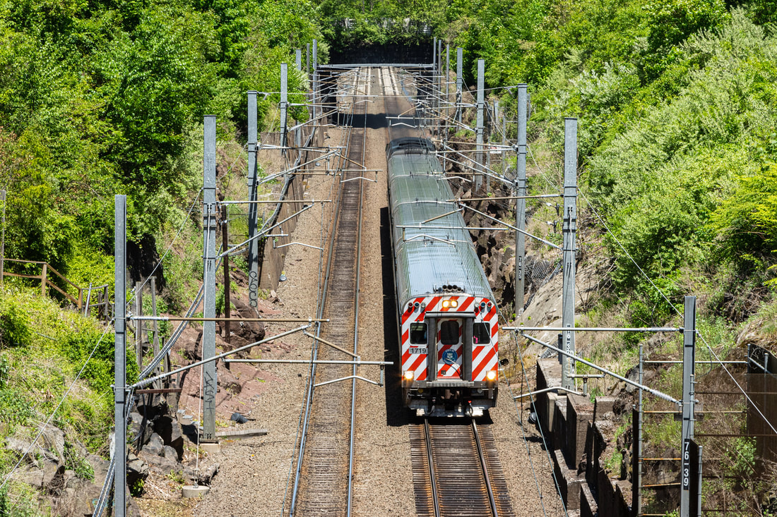
One cannot leave this station without talking about the tunnel below, that is, compass south but railroad east. This part of Fair Haven lies within the city of New Haven ever since the Annex was ceded from East Haven in the 1880s; all too common references to the East Haven tunnel(s) are incorrect. The work was reported in July, 1893 to be commencing on September 1, 900 feet in length, "a pretty big piece of engineering," to be completed in about a year. While exact figures vary without further research, the tunnel was 20 feet high, enough to allow brakemen to stand atop cars in the custom of the day, 28 feet wide with ample room for double tracks, and the 16,000 cubic feet of rock to be blasted was to be used as fill and foundations elsewhere. One article says that over 2,000,000 bricks would be used for lining the tunnel. Dynamite blasts were "... to be fired at such times as shall be directed by the engineer and according to law." The project went on night and day regardless of weather, Sundays included as it was nearing completion. The reason for the new route was the Shore Line double-tracking which simultaneously eliminated about 15 grade crossings on the old right of way, a feat that would have been impossible except for the new routing. In the days of growth for the city, streets were being extended into the 'suburbs.' One such was Grand Ave eastward from Quinnipiac Ave. to Russell St. where there was argument on how to cross the railroad tracks that were at grade level. An erstwhile Fair Haven Heights station was discussed but the issue was put to rest with the tunnel: no grade crossing, no bridge, no station. The first regular passenger train, the Gilt Edge, was expected to use the new Shore Line on 7/29/1894. It looks like the boys and the horses are hard at work in the view at [1]. The finished portal can be seen in the distance at [2]. The Historic American Engineering Record shots appear to date to 1978. The one at [3] looks railroad west with Russell St. crossing the bore at dead middle in the photo. The image at [4] shows the ventilation shaft looking like it is just south of Russell St. We have marked the portals on the Track 11 Google Earth map snippet at [7]. Clifton St. looks more like an overpass to us but may be what is referred to as another tunnel here; the main bore is under East Grand Ave. Roman Daniels is a talented young photographer whose work is online at Flickr [click here]. At [5] is his shot of a CDOT train heading east on 5/24/2020 from what appears to be the Clifton St. overpass. The amazing shot at [6] is the tunnel interior. [REFS: NHER/07/18/1893/01; WH/11/17/1893/03; HC/12/13/1893/08; NHER/08/10/1894/01][rev050522]
|
|

|
C.O. Dunn Collection
|
TylerCityStation Collection
|
NHRR Facebook Group
|
FAIR HAVEN EAST [NYNH&H, c1875?; depot. 1887]
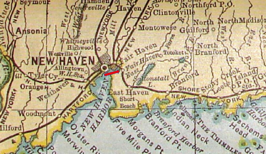
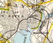
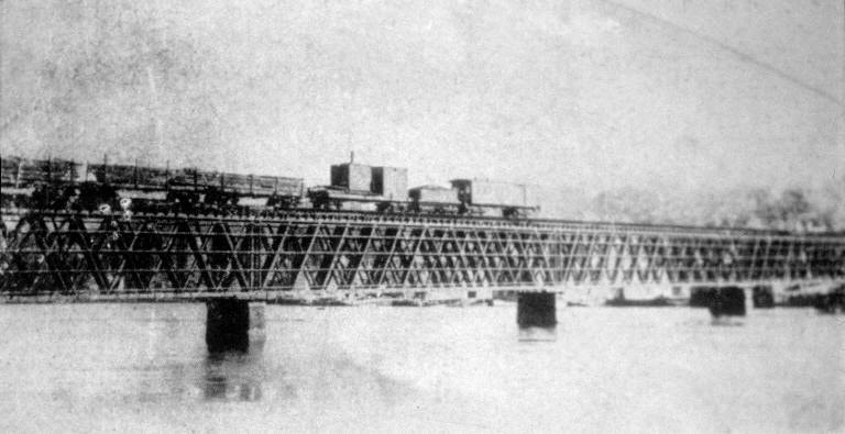
The newspapers reported in 1875 that a "short train" was bringing people to and from the new depot on Meadow St. [NEW HAVEN4] with stops at FAIR HAVEN EAST, FAIR HAVEN (referred to as the 'north station'), MILL RIVER JCT, and the old depot on Chapel St. [NEW HAVEN3]. In 1885, an article said that people of this eastern Elm City borough "were anxiously awaiting" the new depot they had requested, possibly indicating that FAIR HAVEN EAST was only a platform to begin with, and on July 9, 1887 the paper reported that the new station was "being thrown open to the public today." We have no photos yet of any structure and do not know its precise location, though it was likely at either Quinnipiac or Grand Ave. The RAM map at [1] is from 1902; these maps only began showing this stop in 1888 and it disappears with the 1904 map. To add to the confusion, the map appears to show the CEDAR HILL stop as Fair Haven. FAIR HAVEN EAST should not be mistaken for FAIR HAVEN3 [see entry above] on the relocated Shore Line. See the 1893 map at [2] for the old and new alignments and an overview of all of New Haven at that time. The shot at [3] is from our Track 11 Google Earth map and shows the locations of all the 'eastern' stations. The old Shore Line at this time still ran over the 1873 replacement for the 1852 Quinnipiac River bridge built by the NH&NL. This first bridge was unsheathed as seen in the early photo at [4]. The new bridge was up by 9/9/1873 when it was "... being enclosed with boards, by which the frame will be protected from the weather... at the same time bemoaning the fact that "... a handsome landscape [was] cut off from the view of the seventh warders." as seen in the undated photo at [5]. The fabulous aerial shot at [6] looks west and dates to ca. 1893 with the small streetcars running on Grand Ave; we don't see any horses or wires but electricity must have been in use. Though the relatively new 1873 bridge was considered for highway use, its elevation made it unsuitable for public travel and it was torn down late in 1894. By August of that year, Grand Ave. merchants renewed the complaints about the obstructed view of the bridge, now unnecessary. Twenty men were reported at work dismantling it in September and we read in October that "... A section of the west end of the old railroad bridge over the Quinnipiac River has been removed...," the timbers being hoisted onto flat cars via a crane. No date of complete removal has yet been found. Thus severed, the old track east and west of the bridge was left in place to serve remaining local customers and to store cars until the right of way was gradually sold off. [REFS: NHDP/07/01/1873/04; MDC/08/18/173/02; HDC/09/09/1873/04; HDC/03/30/1875/04; NHER/05/17/1875/01; NHJC/05/20/1875/02; NHER/09/15/1885/04; CRC35.1887.17; NHER/07/09/1887/04; NHER/08/10/1894/01; NHER/08/31/1894/01; NHJC/09/24/1894/04; NHJC/10/23/1894/04][rev010917, 050522]
The newspapers reported in 1875 that a "short train" was bringing people to and from the new depot on Meadow St. [NEW HAVEN4] with stops at FAIR HAVEN EAST, FAIR HAVEN (referred to as the 'north station'), MILL RIVER JCT, and the old depot on Chapel St. [NEW HAVEN3]. In 1885, an article said that people of this eastern Elm City borough "were anxiously awaiting" the new depot they had requested, possibly indicating that FAIR HAVEN EAST was only a platform to begin with, and on July 9, 1887 the paper reported that the new station was "being thrown open to the public today." We have no photos yet of any structure and do not know its precise location, though it was likely at either Quinnipiac or Grand Ave. The RAM map at [1] is from 1902; these maps only began showing this stop in 1888 and it disappears with the 1904 map. To add to the confusion, the map appears to show the CEDAR HILL stop as Fair Haven. FAIR HAVEN EAST should not be mistaken for FAIR HAVEN3 [see entry above] on the relocated Shore Line. See the 1893 map at [2] for the old and new alignments and an overview of all of New Haven at that time. The shot at [3] is from our Track 11 Google Earth map and shows the locations of all the 'eastern' stations. The old Shore Line at this time still ran over the 1873 replacement for the 1852 Quinnipiac River bridge built by the NH&NL. This first bridge was unsheathed as seen in the early photo at [4]. The new bridge was up by 9/9/1873 when it was "... being enclosed with boards, by which the frame will be protected from the weather... at the same time bemoaning the fact that "... a handsome landscape [was] cut off from the view of the seventh warders." as seen in the undated photo at [5]. The fabulous aerial shot at [6] looks west and dates to ca. 1893 with the small streetcars running on Grand Ave; we don't see any horses or wires but electricity must have been in use. Though the relatively new 1873 bridge was considered for highway use, its elevation made it unsuitable for public travel and it was torn down late in 1894. By August of that year, Grand Ave. merchants renewed the complaints about the obstructed view of the bridge, now unnecessary. Twenty men were reported at work dismantling it in September and we read in October that "... A section of the west end of the old railroad bridge over the Quinnipiac River has been removed...," the timbers being hoisted onto flat cars via a crane. No date of complete removal has yet been found. Thus severed, the old track east and west of the bridge was left in place to serve remaining local customers and to store cars until the right of way was gradually sold off. [REFS: NHDP/07/01/1873/04; MDC/08/18/173/02; HDC/09/09/1873/04; HDC/03/30/1875/04; NHER/05/17/1875/01; NHJC/05/20/1875/02; NHER/09/15/1885/04; CRC35.1887.17; NHER/07/09/1887/04; NHER/08/10/1894/01; NHER/08/31/1894/01; NHJC/09/24/1894/04; NHJC/10/23/1894/04][rev010917, 050522]

FAIRFIELD1 [NY&NH, 1848]
This depot was on the eastbound (south) side of the track, as seen in the 1856FC map. This station burned in the fall of 1882 and surprisingly the only newspaper coverage we have been able to find is from Pennsylvania and Massachusetts. From the latter, the Boston Daily Advertiser said: "Railway Depot Destroyed… The passenger depot and freight house of the New York and New Haven Railroad at Fairfield were totally destroyed by fire about 3 o’clock this morning. Considerable freight was destroyed. The fire was started in the roof from sparks from a passing train. Loss not over $300 and covered by insurance." Even with depreciation, it is hard to understand how the loss would be so lightly valued, unless this amount was only covering the freight. No photograph has yet been found but it probably looked like GREENWICH1 or STRATFORD1. [REFS: BDA/10/03/1882/01][rev032113]
This depot was on the eastbound (south) side of the track, as seen in the 1856FC map. This station burned in the fall of 1882 and surprisingly the only newspaper coverage we have been able to find is from Pennsylvania and Massachusetts. From the latter, the Boston Daily Advertiser said: "Railway Depot Destroyed… The passenger depot and freight house of the New York and New Haven Railroad at Fairfield were totally destroyed by fire about 3 o’clock this morning. Considerable freight was destroyed. The fire was started in the roof from sparks from a passing train. Loss not over $300 and covered by insurance." Even with depreciation, it is hard to understand how the loss would be so lightly valued, unless this amount was only covering the freight. No photograph has yet been found but it probably looked like GREENWICH1 or STRATFORD1. [REFS: BDA/10/03/1882/01][rev032113]

FAIRFIELD2 [NYNH&H, 1883]
This brick station replaced FAIRFIELD1 in 1883 on the eastbound side of the tracks at a cost of $3751. The Register obliquely acknowledged the opening of the new structure in August when it said that "Fairfield people congratulate themselves on having the finest railroad depot between New Haven and New York." No mention is made of it being new or the burning of FAIRFIELD1 that led to the need for it. It was given a NRHP designation [click here] in 1989 and still stands today in 2012. The 1882 build date that the NRHP gives is in all likelihood off by a year since we now know that the first station burned late in 1882 and FAIRFIELD2 was first mentioned in the news in August of 1883. [REFS: NHER/08/02/1883/04; CRC31.1884.20; NHAR12.1884.8; R51][rev100112]
This brick station replaced FAIRFIELD1 in 1883 on the eastbound side of the tracks at a cost of $3751. The Register obliquely acknowledged the opening of the new structure in August when it said that "Fairfield people congratulate themselves on having the finest railroad depot between New Haven and New York." No mention is made of it being new or the burning of FAIRFIELD1 that led to the need for it. It was given a NRHP designation [click here] in 1989 and still stands today in 2012. The 1882 build date that the NRHP gives is in all likelihood off by a year since we now know that the first station burned late in 1882 and FAIRFIELD2 was first mentioned in the news in August of 1883. [REFS: NHER/08/02/1883/04; CRC31.1884.20; NHAR12.1884.8; R51][rev100112]
|
|
|
FAIRFIELD3 [NYNH&H, c1892]
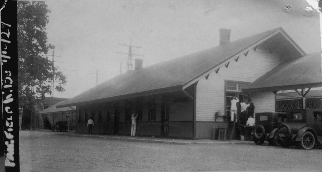
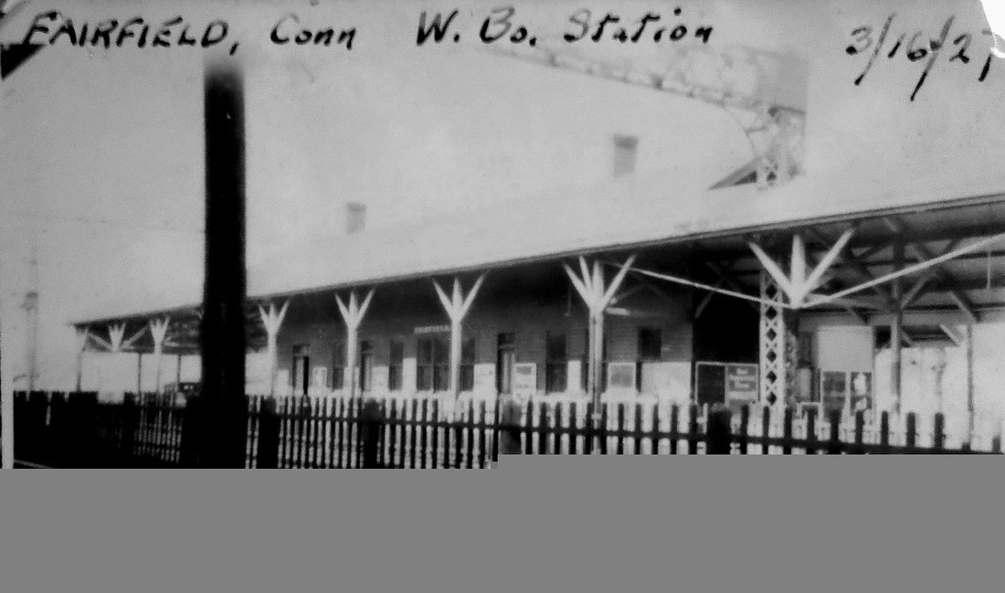
Built with the four-tracking project of the early 1890s, this saltbox-style depot still stands today on the westbound side of the main line. The val photo at [1] is dated 1916, month and day illegible. Workers are on the job 'doing windows' in the 1927 PUC shot at [2]. All the photos look east toward New Haven, except the 3/16/1927 frontal view at [3], which looks north. The image at [4] still looks to us like three tracks, not the four it would soon be, so the dating of this photo is unclear, perhaps 1892 or 1893. [REFS: R52][rev111820]
Built with the four-tracking project of the early 1890s, this saltbox-style depot still stands today on the westbound side of the main line. The val photo at [1] is dated 1916, month and day illegible. Workers are on the job 'doing windows' in the 1927 PUC shot at [2]. All the photos look east toward New Haven, except the 3/16/1927 frontal view at [3], which looks north. The image at [4] still looks to us like three tracks, not the four it would soon be, so the dating of this photo is unclear, perhaps 1892 or 1893. [REFS: R52][rev111820]

Fairview IOOF Collection
|
|
|
FAIRVIEW [NYNH&H, c1910?]
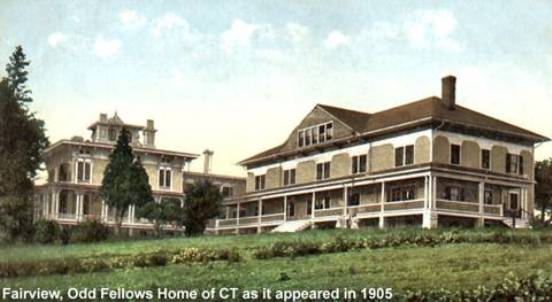
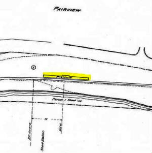
Sometimes appearing on timetables as FAIR VIEW, this was a special Groton stop to accommodate residents and visitors to the Odd Fellows Home, which opened in 1893. The N&W extension to Groton was built in 1899 but this stop does not appear even as late as ETT49 (6/15/1908). A 3/2/1913 Lines East timetable, the earliest that we have available, shows flag stop service here for two daily and two Sunday trains each way. The 1915 val map [click here] shows just the platform that we have highlighted in yellow in the snippet to the left. The stop is on our 1928 official list of stations, probably its last appearance due to the elimination of local service on this line in that year. The residential facility still serves senior citizens today [click here] and P&W trains still pass by on the track below the home, which is appropriately named for the magnificent vista of the Thames River. Our thanks to the folks at Fairview who contributed the photo at upper left, which shows visitors arriving by train on 4/26/1913. [REFS: HC/04/27/1893/06; ICC1919; OL1923; OL1928; C45]
Sometimes appearing on timetables as FAIR VIEW, this was a special Groton stop to accommodate residents and visitors to the Odd Fellows Home, which opened in 1893. The N&W extension to Groton was built in 1899 but this stop does not appear even as late as ETT49 (6/15/1908). A 3/2/1913 Lines East timetable, the earliest that we have available, shows flag stop service here for two daily and two Sunday trains each way. The 1915 val map [click here] shows just the platform that we have highlighted in yellow in the snippet to the left. The stop is on our 1928 official list of stations, probably its last appearance due to the elimination of local service on this line in that year. The residential facility still serves senior citizens today [click here] and P&W trains still pass by on the track below the home, which is appropriately named for the magnificent vista of the Thames River. Our thanks to the folks at Fairview who contributed the photo at upper left, which shows visitors arriving by train on 4/26/1913. [REFS: HC/04/27/1893/06; ICC1919; OL1923; OL1928; C45]

FALLS VILLAGE1 [HRR, 1842]
We have added this new entry because we think the station in our next entry looks too large to have been built when the railroad came in 1842. That there was an early depot here in the town of Canaan is borne out by several newspaper references and the 1859LC map shows the location at the red arrow. Whatever the first station looked like, it apparently saw the arrival of no less than 5,000 people in at least one political rally in 1844, reportedly under the auspices of the Ames Iron Works. The blue arrow on the map points to the complex on the west bank, which is actually in the town of Salisbury, and also shows the spur that bridge the river and provided rail access for the plant probably from 1842. Founded in 1834, Ames produced products from railroad tires to military cannon until a slump after the Civil War caused the business to be sold to the HRR. For the bargain price of $75.000, the railroad got the massive complex consisting of some 20 buildings, 60 acres of land, water rights at the village's namesake Great Falls, and all the materiel and equipment including the big steam hammer, Thor. The railroad quickly set about converting the complex to its purposes of building and repairing locomotives and cars. The location, more or less half way between Bridgeport and Pittsfield, was thought to be ideal for its principal maintenance facility. The NYNH&H would lease the HRR in 1892 and close the Falls Village shops in 1898, moving the remaining equipment to New Haven. [REFS: RF/08/08/1844/02; RF/10/01/1844/03; RF/12/28/1847/02; CC/08/15/1850/95; CC/07/26/1862/01; HDC/05/04/ 1871/04; CC/08/19/1871/02][add031713]
We have added this new entry because we think the station in our next entry looks too large to have been built when the railroad came in 1842. That there was an early depot here in the town of Canaan is borne out by several newspaper references and the 1859LC map shows the location at the red arrow. Whatever the first station looked like, it apparently saw the arrival of no less than 5,000 people in at least one political rally in 1844, reportedly under the auspices of the Ames Iron Works. The blue arrow on the map points to the complex on the west bank, which is actually in the town of Salisbury, and also shows the spur that bridge the river and provided rail access for the plant probably from 1842. Founded in 1834, Ames produced products from railroad tires to military cannon until a slump after the Civil War caused the business to be sold to the HRR. For the bargain price of $75.000, the railroad got the massive complex consisting of some 20 buildings, 60 acres of land, water rights at the village's namesake Great Falls, and all the materiel and equipment including the big steam hammer, Thor. The railroad quickly set about converting the complex to its purposes of building and repairing locomotives and cars. The location, more or less half way between Bridgeport and Pittsfield, was thought to be ideal for its principal maintenance facility. The NYNH&H would lease the HRR in 1892 and close the Falls Village shops in 1898, moving the remaining equipment to New Haven. [REFS: RF/08/08/1844/02; RF/10/01/1844/03; RF/12/28/1847/02; CC/08/15/1850/95; CC/07/26/1862/01; HDC/05/04/ 1871/04; CC/08/19/1871/02][add031713]
Dave Peters Collection
|

|
|
|

Connecticut Historical Society
|
|
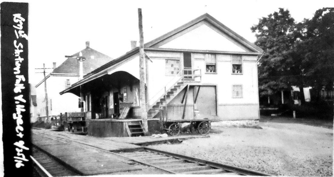
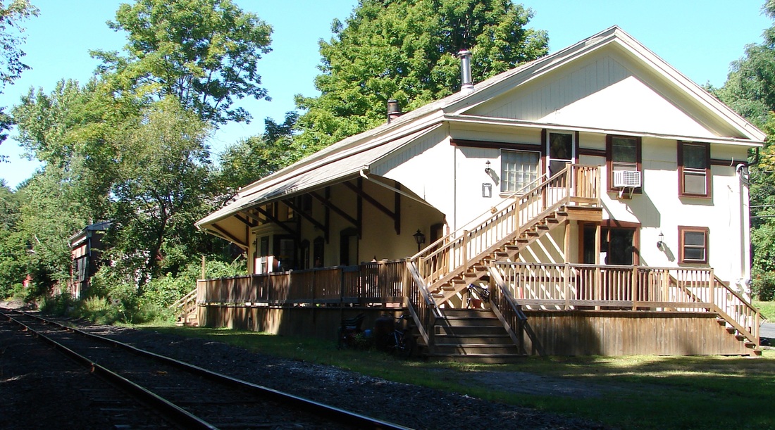
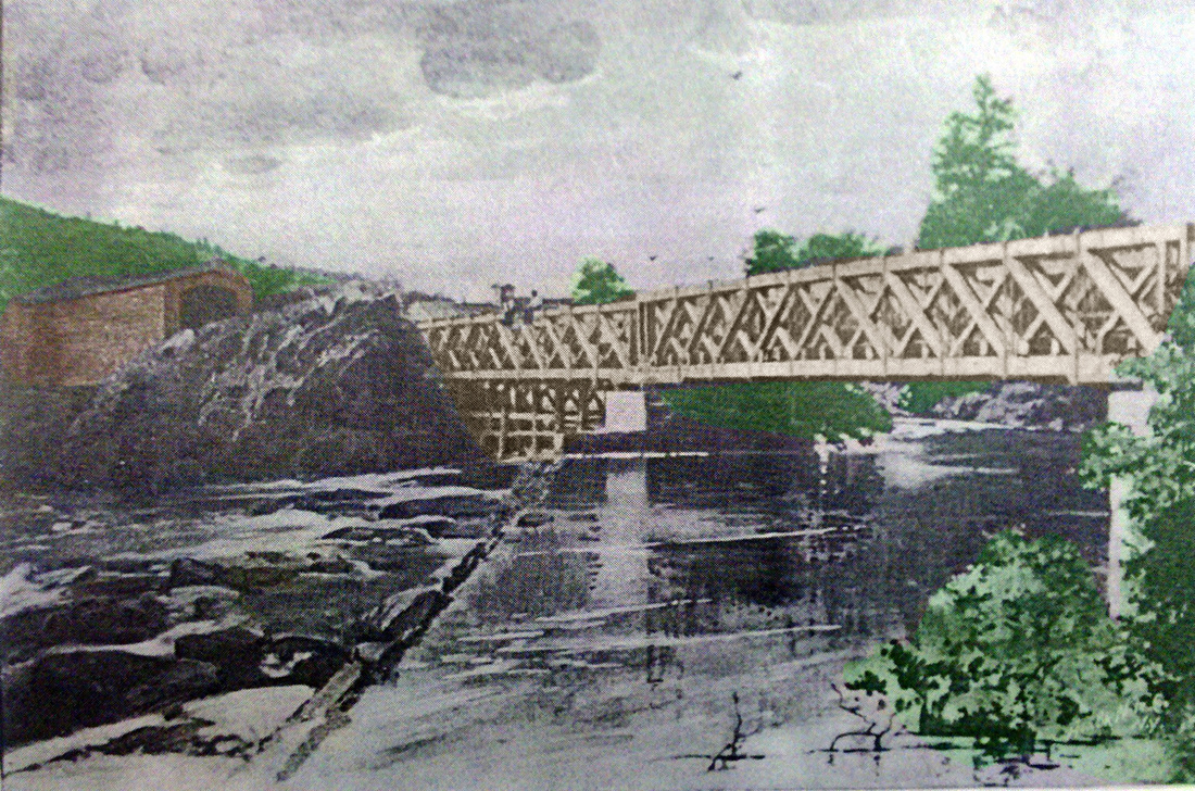
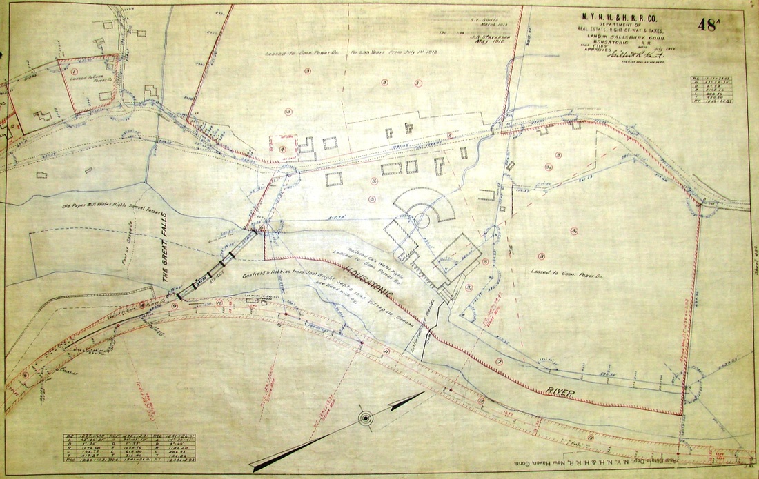
FALLS VILLAGE2 [HRR, 1871]
The val photo at upper left is dated 9/25/1916. While we have yet found no direct evidence, we think this station was built around 1871. That exact year is when the iron works was purchased and also when WEST CORNWALL2 and LIME ROCK1, depots of a similar design, were put up. The station is still extant today, as seen at upper right, and houses the Canaan Historical Society museum on the ground floor. The photo on the lower left shows an 1899 view of the rather unique, partly covered, bridge that was used by pedestrians and the railroad alike. The shops and rail cars are seen in the distance and a westward view of the complex is pictured at lower middle. The map at lower right dates to 1916 and shows the former shop area on lands then leased by the NYNH&H to the Connecticut Power Co. Now part of Connecticut Light & Power, the plant still generates electricity from the Great Falls today. A 3/23/1962 inventory says that the railroad was maintaining the waiting room for passengers and that the freight portion was rented out to Canaan Products. [REFS: LJ/03/17/1900/01; D82; R52][rev010518]
The val photo at upper left is dated 9/25/1916. While we have yet found no direct evidence, we think this station was built around 1871. That exact year is when the iron works was purchased and also when WEST CORNWALL2 and LIME ROCK1, depots of a similar design, were put up. The station is still extant today, as seen at upper right, and houses the Canaan Historical Society museum on the ground floor. The photo on the lower left shows an 1899 view of the rather unique, partly covered, bridge that was used by pedestrians and the railroad alike. The shops and rail cars are seen in the distance and a westward view of the complex is pictured at lower middle. The map at lower right dates to 1916 and shows the former shop area on lands then leased by the NYNH&H to the Connecticut Power Co. Now part of Connecticut Light & Power, the plant still generates electricity from the Great Falls today. A 3/23/1962 inventory says that the railroad was maintaining the waiting room for passengers and that the freight portion was rented out to Canaan Products. [REFS: LJ/03/17/1900/01; D82; R52][rev010518]

FARMINGTON1 [NH&N, 1848]
This station was located as seen on the 1855HC map. According to the Register, this station burned on 3/20/1886 in an early morning lightning storm that also destroyed the NY&NE BRISTOL1 depot and struck the Canal line's CHESHIRE depot as well. The structure here was described as "old and dilapidated... a one storied shanty of the regulation provincial type for country stations. The platform in front of it was only four feet wide. It was an important station only because passengers changed cars here to go up on the New Hartford branch." We have found no photograph yet of this station. [REFS: NHER/03/20/1886/01; NHER/05/28/1886/04; HDC/03/22/1886/03]
This station was located as seen on the 1855HC map. According to the Register, this station burned on 3/20/1886 in an early morning lightning storm that also destroyed the NY&NE BRISTOL1 depot and struck the Canal line's CHESHIRE depot as well. The structure here was described as "old and dilapidated... a one storied shanty of the regulation provincial type for country stations. The platform in front of it was only four feet wide. It was an important station only because passengers changed cars here to go up on the New Hartford branch." We have found no photograph yet of this station. [REFS: NHER/03/20/1886/01; NHER/05/28/1886/04; HDC/03/22/1886/03]

|
|
FARMINGTON2 [NH&N, 1886]
For all the newspaper talk above of this station's unimportance, the Canal road's replacement for the earlier depot left nothing to be envied along the line. The new cross-gabled brick structure looks virtually identical to MOUNT CARMEL4 and was up by the end of 1886. The railroad commissioners said that a "neat and tasteful brick passenger depot" had been built here. A matching, octagonal brick-enclosure covered the water tank. The commissioners mention that the covershed over the platform that we see was added in 1888. [REFS: CRC34.1886.9; CRC36.1888.21; D109]
For all the newspaper talk above of this station's unimportance, the Canal road's replacement for the earlier depot left nothing to be envied along the line. The new cross-gabled brick structure looks virtually identical to MOUNT CARMEL4 and was up by the end of 1886. The railroad commissioners said that a "neat and tasteful brick passenger depot" had been built here. A matching, octagonal brick-enclosure covered the water tank. The commissioners mention that the covershed over the platform that we see was added in 1888. [REFS: CRC34.1886.9; CRC36.1888.21; D109]
FARMS VILLAGE [> STRATTON BROOK]
FARNHAMS [NYNH&H, c1912]
This was a latter-day stop in EAST WINDSOR on the old CC line, one mile north of RYE STREET. According to the annual report, a new station that we presume to be the first, was built here in 1912-1913. We have no photo yet [REFS: NHAR42.1913.14][rev070215]
This was a latter-day stop in EAST WINDSOR on the old CC line, one mile north of RYE STREET. According to the annual report, a new station that we presume to be the first, was built here in 1912-1913. We have no photo yet [REFS: NHAR42.1913.14][rev070215]

Dave Peters Collection
|

|

|
|

|
|
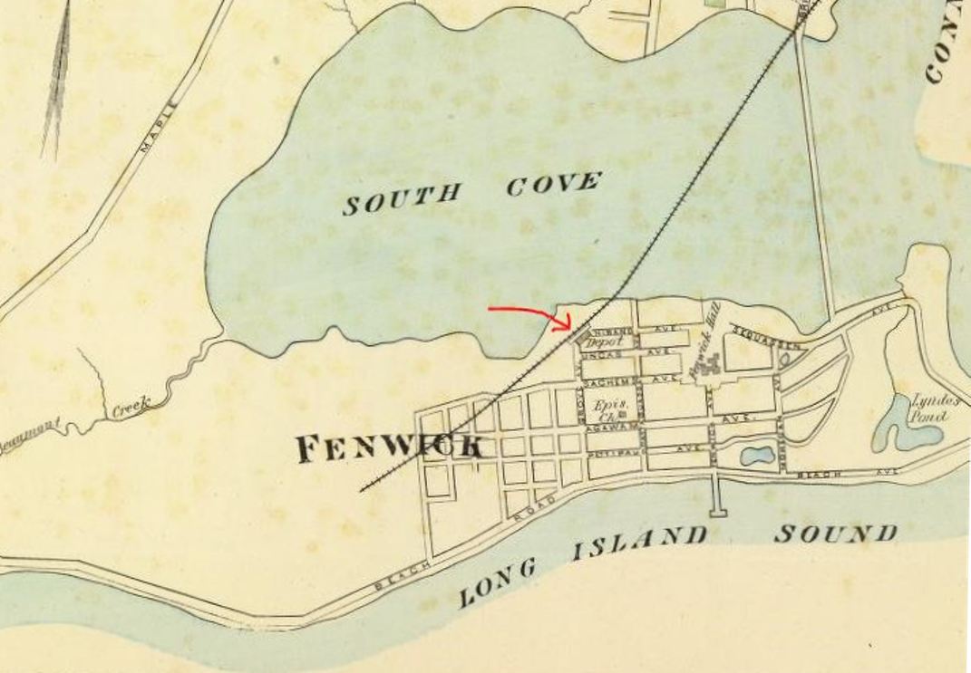
FENWICK [CV, 1872]
Track to his seasonal terminus opened in 1872 with the extension of the CV from its first terminus at SAYBROOK POINT to the grounds of the New Saybrook Company's resort development at Fenwick Hall, which soon became a popular destination for visitors from Hartford. The Courant reported in November, 1871 that the station was under construction and, somewhat prematurely, that cars were expected next week. It was not until summer, 1872 that the extension first debuted. The newspaper said on 6/5/1872 that "Fenwick is the name of the station on the southern terminus of the Valley road" and the railroad commissioners certified the extension as "suitable in condition for the safe operation of engine and cars" on 7/3/1872. The Mansard-roofed structure, standing about 1,000 feet from the end of the track, is seen on the 1893 map at [4]. The building measured 50x25 feet, with an eight-foot overhang all around. The val photo at [1] shows the depot on 8/5/1916 already boarded up as out of service. As Max Miller points out, that shot was 52 days before the structure would be moved a mile north to take the place of the SAYBROOK POINT1 where the station had been wrecked by a train in July of that year and a passenger car used as an interim depot. Seen in the famous shot at [2] FENWICK was jacked up onto two flat cars and pulled by a 'baby engine' on 9/26/1916 to its new location, opening as SAYBROOK POINT2, according to Max on 11/24/1916. The undated image at [3] shows the depot boarded up in later days. Rail service to Fenwick ceased about a year earlier and abandonment was officially requested in 1917 with the town in favor of the ROW being released for use as a highway. Interestingly, the permission for this unusual conversion was granted by special act of the General Assembly on 4/13/1917. The original trestle work of the 27-ft wide railroad causeway was filled in to create today's Rte. 154. The conversion of a railroad to a highway was as novel as it was prophetic, Denver's Rocky Mountain News running an item titled "Autos Force Road To Take Off Trains On Its Branch." Perhaps one of the last trains leaving FENWICK is seen at [5]. The moving of stations on flat cars was fairly common but the image of this one gliding across the South Cove is rather unique and it is not surprising that it was caught on film. The station building was valued at $2,000-$2,500 at the time of the move. It was used as SAYBROOK POINT2 until 1922 when the CV line was further cut back to SAYBROOK. The depot ended its historic existence modified into a refreshment stand as seen at [6]. [REFS: HDC/11/07/1871/02; NA/06/05/1872/03; HDC/08/24/1872/02; HC/05/19/1915/16; HC/09/08/1916/07; HC/09/28/1916/08; HC/10/08/1916/18; RMN/02/22/1917 07; NMB/03/01/1917/07; 1917 Special Act 168; K98; V45,48][rev101717]
FISHERVILLE [> NORTH GROSVENORDALE]
|
National Archives
|
|

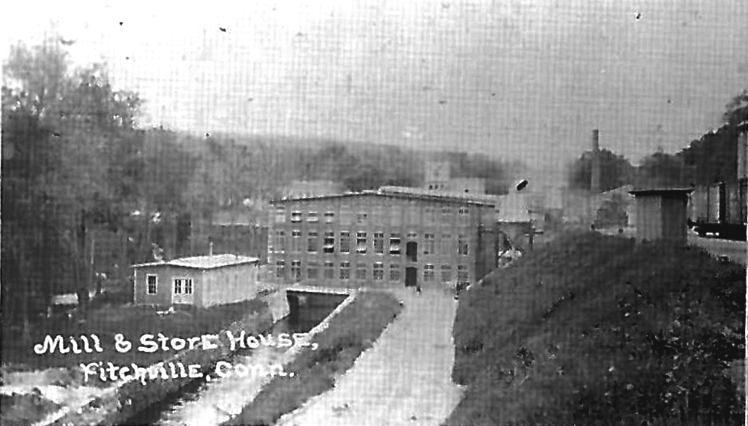
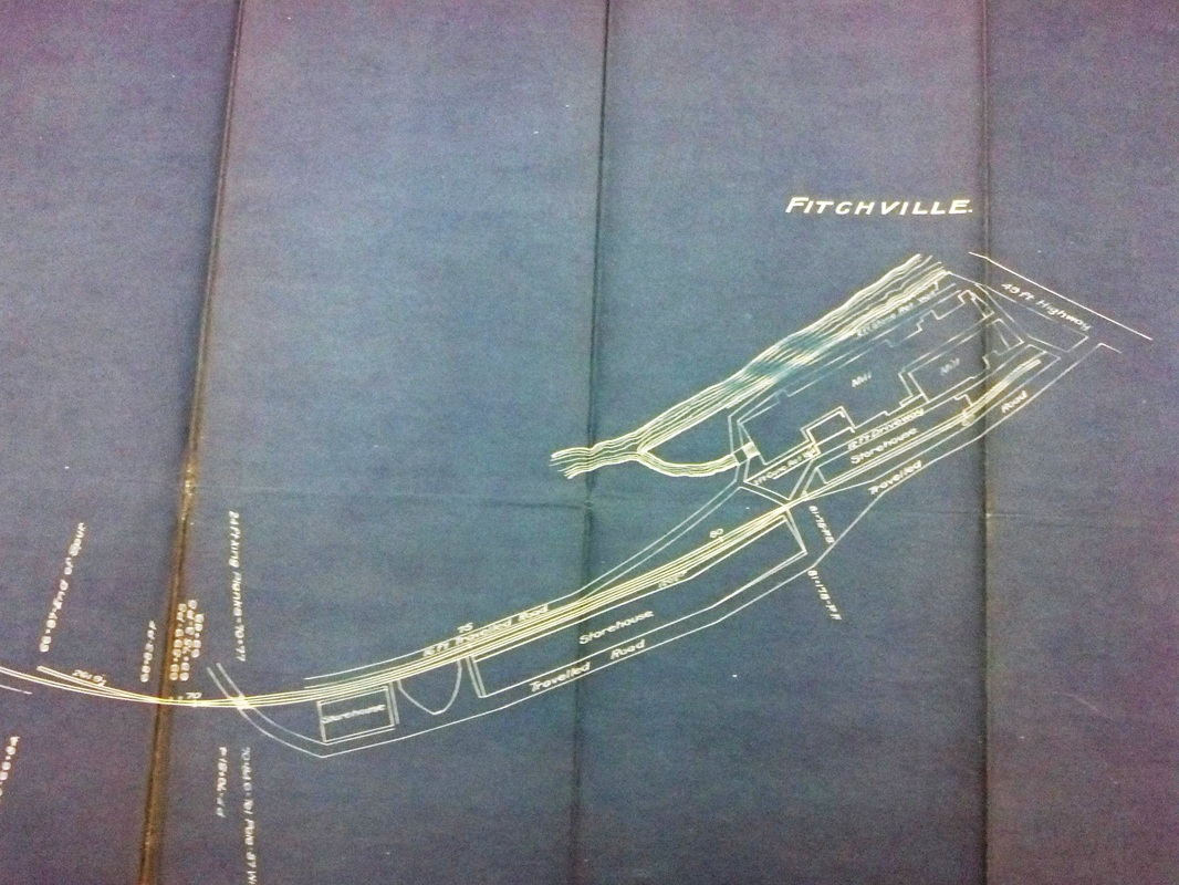
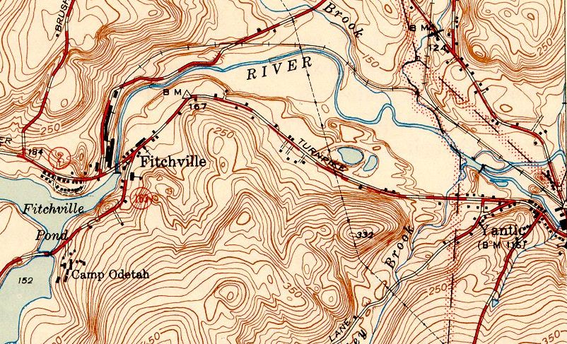
FITCHVILLE [NLN, c1880]
This and the next entry were station points in the town of Bozrah where this short branch came off the NLN. Karr gives the ca. 1880 build date that we have not been able to confirm from the railroad commissioners or the newspapers. The main goal was to serve the sizable cotton mill established by Asa Fitch, an eccentric, self-made millionaire who died unmarried in 1865 and left his fortune to his siblings. He built the village church at his own expense and, going to the nearby tomb that he had constructed for himself, the spring-door reportedly closed and he was almost dead inside when he was rescued. The entire village here was apparently his private property and was later sold to a Providence, RI industrialist. The photo at upper left is an eastward-looking view of the mill complex probably around the turn of the century. On the elevation to the right, one sees a switch shanty, freight cars, and the edge of a water tank. The val map at middle dates to 1916 and the topo map at right is from 1943. Karr says this freight-only branch was abandoned ca. 1980, a century after track was laid. Fitch himself had graded the two-mile branch before he died and rumor was that it was to be extended to Colchester, thereby forming the shortest route, by some ten miles, between New Haven and Norwich. In 2011, the track, some of which is still in the ground, figured in the plan by a local property owner to open a quarry and use rail service to transport the stone. Apparently this trackage is on privately owned land and no longer associated with any railroad since it does not appear on our 2007 DOT rail ownership map. The May, 2013 photo at lower left shows trees growing between the rails which we found ending just east of Stockhouse Rd. We may recheck on our next visit to see if anything is still in place on the other side of the road. Click here for John Roy's recent video of the Fitchville branch. [REFS: SR/11/01/1865/08; HDC/11/02/1865/02; CC/07/01/1865/04; CC/09/11/1869/02; NLD/06/11/1870/01; NA/12/07/1870/03; HC/07 /08/1932/07; HC/05/22/2011/C7; NB/06/10/2011/00; NLD/07/08/2011/00; C77; K104][rev030315]
This and the next entry were station points in the town of Bozrah where this short branch came off the NLN. Karr gives the ca. 1880 build date that we have not been able to confirm from the railroad commissioners or the newspapers. The main goal was to serve the sizable cotton mill established by Asa Fitch, an eccentric, self-made millionaire who died unmarried in 1865 and left his fortune to his siblings. He built the village church at his own expense and, going to the nearby tomb that he had constructed for himself, the spring-door reportedly closed and he was almost dead inside when he was rescued. The entire village here was apparently his private property and was later sold to a Providence, RI industrialist. The photo at upper left is an eastward-looking view of the mill complex probably around the turn of the century. On the elevation to the right, one sees a switch shanty, freight cars, and the edge of a water tank. The val map at middle dates to 1916 and the topo map at right is from 1943. Karr says this freight-only branch was abandoned ca. 1980, a century after track was laid. Fitch himself had graded the two-mile branch before he died and rumor was that it was to be extended to Colchester, thereby forming the shortest route, by some ten miles, between New Haven and Norwich. In 2011, the track, some of which is still in the ground, figured in the plan by a local property owner to open a quarry and use rail service to transport the stone. Apparently this trackage is on privately owned land and no longer associated with any railroad since it does not appear on our 2007 DOT rail ownership map. The May, 2013 photo at lower left shows trees growing between the rails which we found ending just east of Stockhouse Rd. We may recheck on our next visit to see if anything is still in place on the other side of the road. Click here for John Roy's recent video of the Fitchville branch. [REFS: SR/11/01/1865/08; HDC/11/02/1865/02; CC/07/01/1865/04; CC/09/11/1869/02; NLD/06/11/1870/01; NA/12/07/1870/03; HC/07 /08/1932/07; HC/05/22/2011/C7; NB/06/10/2011/00; NLD/07/08/2011/00; C77; K104][rev030315]
FITCHVILLE JUNCTION [NLN, c1880; later called GIBBS]
FIVE MILE RIVER [> ROWAYTON]
FLANDERS [> NORTH KENT]
Max Miller Collection
|
|


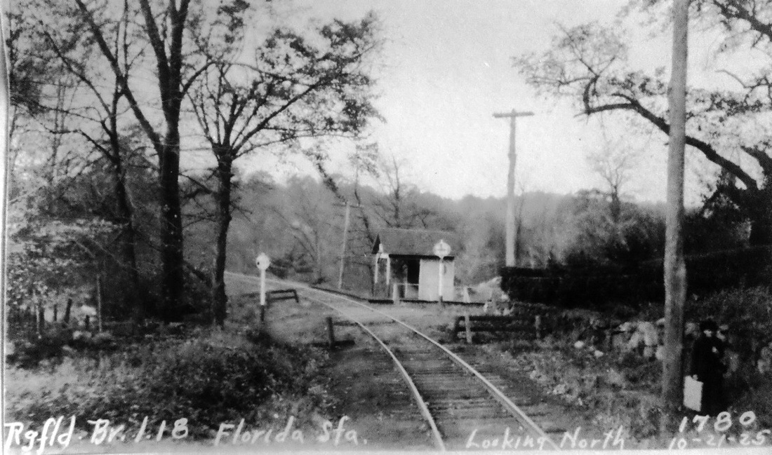
FLORIDA [NYNH&H, c1900?]
This small shelter stood in the town of Ridgefield about a mile above BRANCHVILLE on the D&N branch. This is not listed on the RRMs or in the GHDs, but does appear on the 1904 RAM map and it is on our rev7/8/1907 timetable. The north-looking view at [1] is from the PUC inspection of 10/21/25. The val map at [4] looks south, putting the station in the northwest quadrant of the grade crossing, with RIDGEFIELD to the right. [rev012416]
This small shelter stood in the town of Ridgefield about a mile above BRANCHVILLE on the D&N branch. This is not listed on the RRMs or in the GHDs, but does appear on the 1904 RAM map and it is on our rev7/8/1907 timetable. The north-looking view at [1] is from the PUC inspection of 10/21/25. The val map at [4] looks south, putting the station in the northwest quadrant of the grade crossing, with RIDGEFIELD to the right. [rev012416]
|

|
|
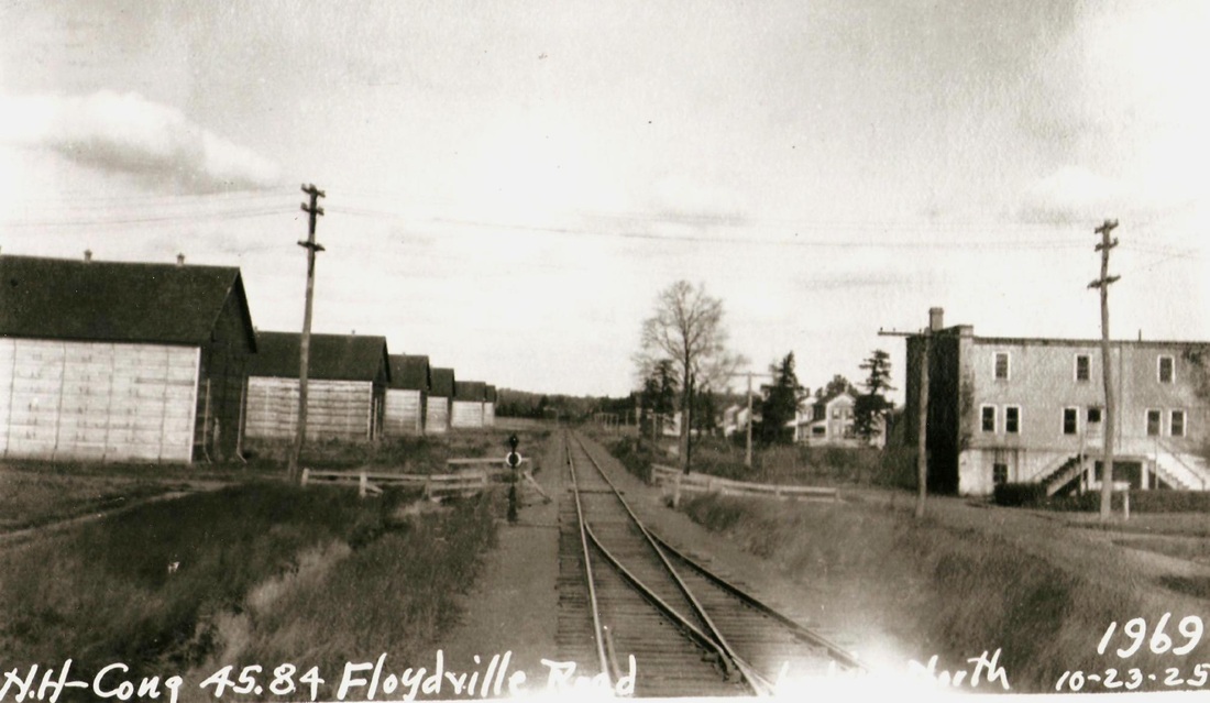
FLOYDVILLE [NYNH&H, 1910]
The 10/23/1925 PUC photograph shows a northward view of the Floydville Rd. crossing in the town of East Granby, just over the Simsbury line. The structures on the left are storage barns belonging to Marcus L. Floyd's Connecticut Tobacco Corp., which had just expanded operations in this area. The newspaper said that a "station would be built in the coming week," to be used mostly for freight but would be a flag stop for passengers as well. The article gives the location incorrectly as two miles below the East Granby station, which was on the CNE. The stop was, in fact, about one mile below Granby on the Canal line. The 1912 real estate map at middle shows the platform on the east side of the track, perhaps moved to the opposite side of the track when the siding was installed. The snippet from the 1915 val map [click here] at right still shows just a platform, now west of the track and behind our photographer. [REFS: HC/10/13/1910/11; K69][rev100112]
The 10/23/1925 PUC photograph shows a northward view of the Floydville Rd. crossing in the town of East Granby, just over the Simsbury line. The structures on the left are storage barns belonging to Marcus L. Floyd's Connecticut Tobacco Corp., which had just expanded operations in this area. The newspaper said that a "station would be built in the coming week," to be used mostly for freight but would be a flag stop for passengers as well. The article gives the location incorrectly as two miles below the East Granby station, which was on the CNE. The stop was, in fact, about one mile below Granby on the Canal line. The 1912 real estate map at middle shows the platform on the east side of the track, perhaps moved to the opposite side of the track when the siding was installed. The snippet from the 1915 val map [click here] at right still shows just a platform, now west of the track and behind our photographer. [REFS: HC/10/13/1910/11; K69][rev100112]
Dave Peters Collection
FLUTEVILLE [NRR, c1864]
This station was in the town of Litchfield. The Middletown newspaper said in 1874 that "The new post office at Fluteville is doing well. Three letters and a newspaper passed through the office last week, and the sale of stamps amounted to fourteen cents." The sarcasm is duly noted, but even with its charming and historic name, this was never to be a stop of more than modest importance. The first listing we see is on an NRR passenger rate card for 1864. Not surprisingly there was a factory here that had done a large business for many years making flutes and other musical instruments. Being converted to the manufacture of cutlery in 1879, the facility was said to be "but a few feet from the Naugatuck railroad, where there is a signal platform." This sounds like a flag stop to us. The railroad commissioners, whatever their criteria were, never saw fit to put FLUTEVILLE on the map, so to speak, though many similar places of limited patronage were included on the map that came with their annual reports starting in 1876. Probably the only one to stand here, this classy little structure was likely put up in the late 1880s, with its slate-covered, hipped roof and twin finials. This stop, along with several others on the NRR from Waterbury to Winsted, lost passenger service in 1926. [REFS: DC/02/20/1874/02; HDC/02/10/1879/04; HC/06/20/1926/A12; GHD1884; D92]
This station was in the town of Litchfield. The Middletown newspaper said in 1874 that "The new post office at Fluteville is doing well. Three letters and a newspaper passed through the office last week, and the sale of stamps amounted to fourteen cents." The sarcasm is duly noted, but even with its charming and historic name, this was never to be a stop of more than modest importance. The first listing we see is on an NRR passenger rate card for 1864. Not surprisingly there was a factory here that had done a large business for many years making flutes and other musical instruments. Being converted to the manufacture of cutlery in 1879, the facility was said to be "but a few feet from the Naugatuck railroad, where there is a signal platform." This sounds like a flag stop to us. The railroad commissioners, whatever their criteria were, never saw fit to put FLUTEVILLE on the map, so to speak, though many similar places of limited patronage were included on the map that came with their annual reports starting in 1876. Probably the only one to stand here, this classy little structure was likely put up in the late 1880s, with its slate-covered, hipped roof and twin finials. This stop, along with several others on the NRR from Waterbury to Winsted, lost passenger service in 1926. [REFS: DC/02/20/1874/02; HDC/02/10/1879/04; HC/06/20/1926/A12; GHD1884; D92]
FOLEYS [> WASHINING]

|
|
Ramsdell Transportation Collection
|
 Bristol Public Library
FORESTVILLE1 [HP&F, 1850]
This stop in the town of Bristol dates to the opening of the HP&F. Track was completed to Bristol on 6/1/1850 and there may have been a celebratory train on that day but the newspaper timetables in the Courant show 6/18/1850 as when rail service commenced on a regular basis. The first oblique mention of this depot is in an ad for a farm for sale in 1852 "... about one mile easterly of the Bristol Central depot and one mile westerly of the Forestville depot." The only image we have found of FORESTVILLE1 is on the 1880 O.H. Bailey bird's-eye map at [1] which shows a diminutive, hip-roofed structure sitting on the west side of Center St. The freight house is over to the left, both structures on the north side of the track. This is a fortunate coincidence of timing since this depot, dilapidated after 30 years of use, would be replaced in 1881 after many complaints. The newspaper of 12/16/1881 said: "The old depot is going fast, some of the verandah posts have rotted off and fallen down and now the platform is going to the 'demolition bow-wows.' Let her went (sic), and then see if a village of 1500 inhabitants, together with a large manufacturing business, cannot be provided with a depot that is not a standing disgrace to both the village and the road." A subsequent article said the NY&NE had ordered better upkeep at its stations and, seemingly tongue-in-cheek, the paper suggested polishing the overhead ventilator, new brussels (sic) carpeting and settees, retouching the frescoing inside and out, and new cups for the marble drinking fountain! Then, it said, "if the boys have done using the corner posts for ball bats, they might be returned... and our martin box [would] shine like a glass bottle and be an ornament and pride to the village." By May, 1881, the rumor of new rail lines coming through here provoked the depot comment "... for we probably shall never get a new one until the cockroaches succeed in carting off the old." The 1874 map at [2] shows the location, with the Pequabuck River running just south of the track. The photo at [3] looks east with the freight house at middle left. The view reportedly dates to 1880, FORESTVILLE1 presumably hidden behind the freight house. Note the giant water tank at right. The building with the cupola in the far distance is the Welch, Spring & Co. factory, one of the clock makers for which Forestville and Bristol were famous. Jay Critchley's expansive 1973 Bristol Press article says that this first station burned and a temporary depot was used before FORESTVILLE2 was completed late in 1881, the first point being untrue and second point true. The article has a number of interesting details about the coming of the railroad, the local rivalry with East Bristol for placement of the station and that Forestville folks said that the HP&F stood for Hartford, Plainville & Forestville! Critchley also seems to have relied on Carleton Beal's book for the claim that the first train in 1850 was pulled by the locomotive Comet. In fact, we can find no such named engine on Charles Fisher's HP&F/NY&NE roster and the photo of the locomotive from the book, seen here at [4], has Hartford & New Haven RR markings. The verified build date of 1864 precludes an 1850 appearance. NYNH&H loco guru Charlie Dunn tells us that there were four engines on the HP&F roster that could have done the honors, one of them named Bristol. How appropriate if we could find that to be true! [REFS: HTI/09/14/1850/02; CC/01/10/1852/04; BWP/12/16/1880/03; BWP/01/20/1881/03; BWP/04/07/1881/03; BWP/05/26/1881/02; BWP/06/23/1881/03: depot improved?, need telescope to see repairs; BWP/12/22/1881/03; BPR/01/26/1973/11 (Critchley); Edson/Fisher, p12,83ff,93; Carleton Beals, The Making of Bristol, 1954, pp135-136; C173ff; K85; R53][rev11/03/20, 11/22/20, 103021]
This stop in the town of Bristol dates to the opening of the HP&F. Track was completed to Bristol on 6/1/1850 and there may have been a celebratory train on that day but the newspaper timetables in the Courant show 6/18/1850 as when rail service commenced on a regular basis. The first oblique mention of this depot is in an ad for a farm for sale in 1852 "... about one mile easterly of the Bristol Central depot and one mile westerly of the Forestville depot." The only image we have found of FORESTVILLE1 is on the 1880 O.H. Bailey bird's-eye map at [1] which shows a diminutive, hip-roofed structure sitting on the west side of Center St. The freight house is over to the left, both structures on the north side of the track. This is a fortunate coincidence of timing since this depot, dilapidated after 30 years of use, would be replaced in 1881 after many complaints. The newspaper of 12/16/1881 said: "The old depot is going fast, some of the verandah posts have rotted off and fallen down and now the platform is going to the 'demolition bow-wows.' Let her went (sic), and then see if a village of 1500 inhabitants, together with a large manufacturing business, cannot be provided with a depot that is not a standing disgrace to both the village and the road." A subsequent article said the NY&NE had ordered better upkeep at its stations and, seemingly tongue-in-cheek, the paper suggested polishing the overhead ventilator, new brussels (sic) carpeting and settees, retouching the frescoing inside and out, and new cups for the marble drinking fountain! Then, it said, "if the boys have done using the corner posts for ball bats, they might be returned... and our martin box [would] shine like a glass bottle and be an ornament and pride to the village." By May, 1881, the rumor of new rail lines coming through here provoked the depot comment "... for we probably shall never get a new one until the cockroaches succeed in carting off the old." The 1874 map at [2] shows the location, with the Pequabuck River running just south of the track. The photo at [3] looks east with the freight house at middle left. The view reportedly dates to 1880, FORESTVILLE1 presumably hidden behind the freight house. Note the giant water tank at right. The building with the cupola in the far distance is the Welch, Spring & Co. factory, one of the clock makers for which Forestville and Bristol were famous. Jay Critchley's expansive 1973 Bristol Press article says that this first station burned and a temporary depot was used before FORESTVILLE2 was completed late in 1881, the first point being untrue and second point true. The article has a number of interesting details about the coming of the railroad, the local rivalry with East Bristol for placement of the station and that Forestville folks said that the HP&F stood for Hartford, Plainville & Forestville! Critchley also seems to have relied on Carleton Beal's book for the claim that the first train in 1850 was pulled by the locomotive Comet. In fact, we can find no such named engine on Charles Fisher's HP&F/NY&NE roster and the photo of the locomotive from the book, seen here at [4], has Hartford & New Haven RR markings. The verified build date of 1864 precludes an 1850 appearance. NYNH&H loco guru Charlie Dunn tells us that there were four engines on the HP&F roster that could have done the honors, one of them named Bristol. How appropriate if we could find that to be true! [REFS: HTI/09/14/1850/02; CC/01/10/1852/04; BWP/12/16/1880/03; BWP/01/20/1881/03; BWP/04/07/1881/03; BWP/05/26/1881/02; BWP/06/23/1881/03: depot improved?, need telescope to see repairs; BWP/12/22/1881/03; BPR/01/26/1973/11 (Critchley); Edson/Fisher, p12,83ff,93; Carleton Beals, The Making of Bristol, 1954, pp135-136; C173ff; K85; R53][rev11/03/20, 11/22/20, 103021]
|
|
UConn Archives & Special Collections
|
Max Miller Collection
|

UConn Archives & Special Collections
|
|
UConn Arch. & Spec. Colls.
FORESTVILLE2 [NY&NE, 1881]
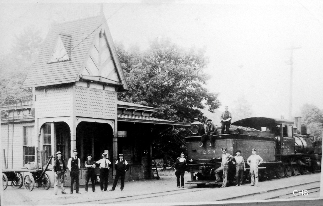
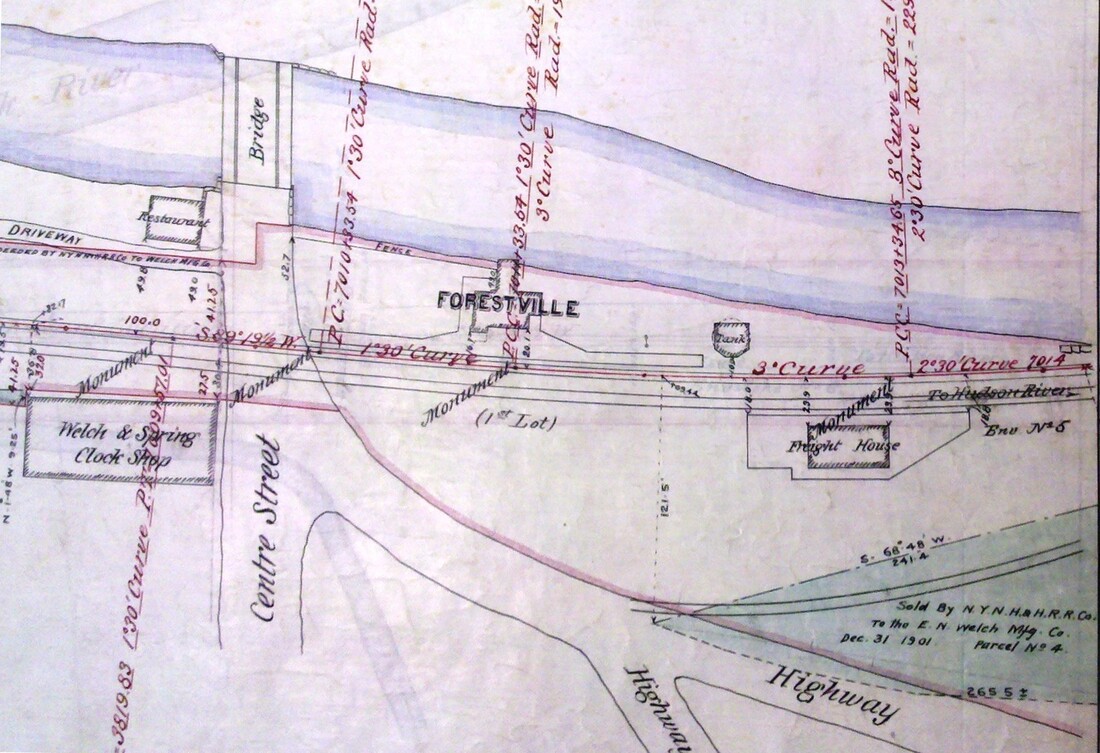
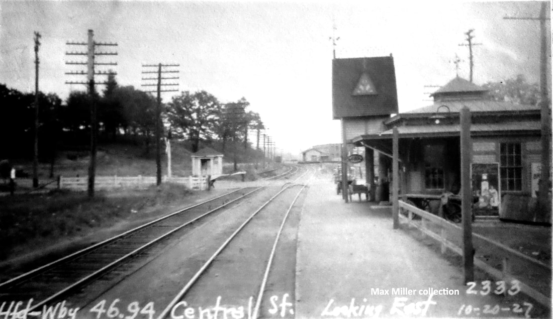
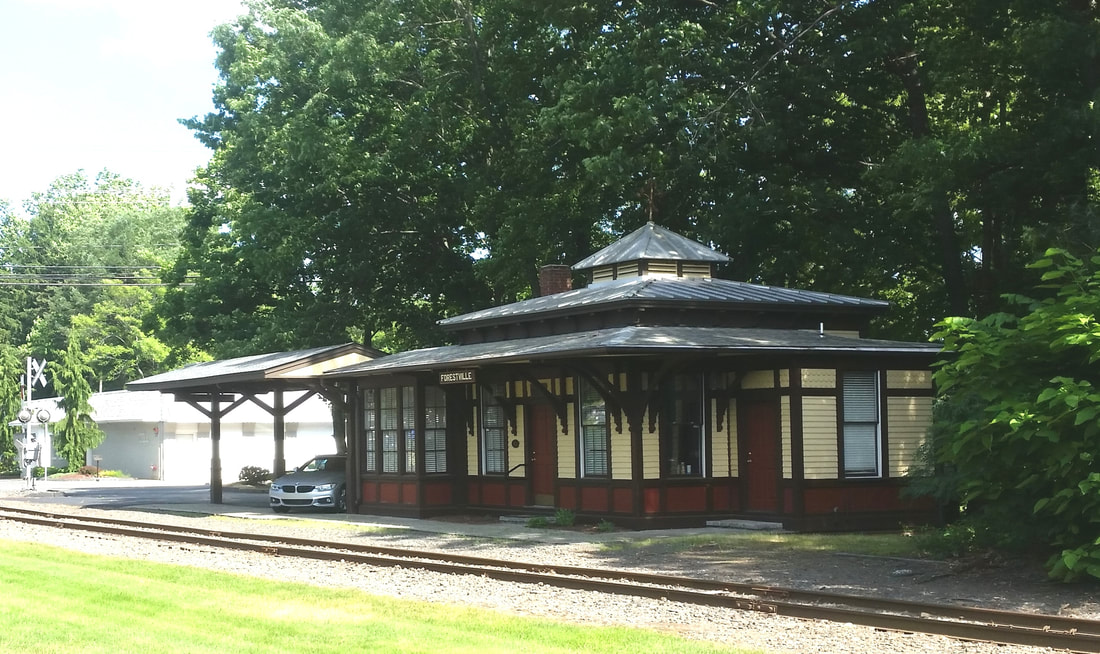
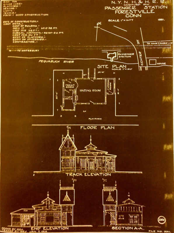
This station was built in 1881 as the railroad commissioners said in their 1882 annual report. A virtually identical depot was put up by the NY&NE in EAST HARTFORD in 1883 and again in 1888 after the earlier one there burned. We know of no other NY&NE stations that were constructed according to this architectural plan, which was apparently available for use for nearly a decade. All the original records show the tower as an integral part of the design and not a later addition. Purely ornamental and whimsical! After complaints as late as May, 1881 noted in the previous entry, the Bristol newspaper crowed suddenly and ecstatically in August, that "The millennium cannot be far off. We are to have a new depot. Already workmen are engaged in building the foundation and tools and materials are constantly arriving. The new structure will be on the main line opposite the present site. We have not yet been able to get the plan but we hope to soon." Imagine their amazement when they saw the tower! The Critchley article says the depot might have been brought over from Colchester but this is contradicted by the successive newspaper reports of on-site construction, including this important note on 9/22/1881 saying "A temporary structure has been erected and the old depot is fast being demolished. Parts of the old framework which were moved across the track Wednesday night will be used in the new building together with Amos' chromos." Amos Sage was the agent of 23 years and we think the chromos was a chromolithograph, a Victorian-era color printing machine. Finally on 12/22/1881 we hear "At last, the new depot is completed. The agent has moved in his effects and the temporary structure is demolished. The new building is tasty [tasteful, in the lingo of that day] but of a style of architecture utterly unknown [italics ours!] and one would judge from its outside look that the agent of some paint manufactory was trying to advertise his goods[!]. So architecturally remarkable and gloriously colorful too. Oh, that we had real photos from the day to show those colors! Inside, the accoutrements included a new regulator clock made by WS&C with a Lewis perpetual calendar attachment. Neatly finished outside as well, it was what locals "have prayed for since the advent of that worthy personage, the 'oldest inhabitant'" [read, since time immemorial!]. We do not know what average daily sales were prior but 163 tickets were sold on a single day late in December. The shot at [1] dates to between 1904 when the Hinkley 2-8-0, nee NY&NE #1013, was renumbered as NYNH&H #253 up until the 10/1913 scrapping of the locomotive. The very handsome train and station crews really add character to the photo. The 1890-revised NY&NE map at [2] shows layout of the grounds. Note the 'Tank' west of the depot and the WS&C factory across the street. The real estate card at [3] was recorded on 12/17/1929 -- note the misspelling of 'reocrd' on the form itself! -- but was updated with items like the removal of the tower in 1930. Too much maintenance, we presume. Many interesting details about the physical property, electrical service, etc. are contained herein. Of most important note right at the top, it says this station dates to 1855 when the HP&F opened. Similar errors have been seen on other cards like this. The eastward-looking view at [4] is a PUC inspection photo dated 10/20/1927. The northwesterly shot at [5] shows the tower gone in 1931. The 1/7/1914 tracing at [7] reproduces the architectural plan of 1881. We took the photo at [6] on 6/20/2018. Placed on the National Register of Historic Places in 1978, the structure is beautifully maintained today by the present owners, Ricci & Co. CPAs. The is a real architectural gem, even without the signature tower. We would be remiss in not adding Rev. Charles H. Riggs to the pantheon of Connecticut newspapermen for his founding of the Bristol Press in 1871 and diligently recording the events that make detailed history like this possible. The Press still operates today. Also meriting praise are the reference librarians, present and past, Claire, Meagan and Jay, at the Bristol Public Library, who have greatly assisted us in our research over the years. [REFS: HDC/05/21/1881/01; BWP/08/25/1881/02; BWP/09/01/1881/02; BWP/09/15/1881/02; BWP/09/22/1881/03; BWP/10/06/1881/03; BWP/10/20/1881/02; BWP/11/17/1881/02: ready for plasterers; BWP/12/22/1881/03; BWP/12/29/1881/02; CRC29.1882.34; BPR/01/26/1973/11; Edson/Fisher p26,95; R53][rev031713, 110320, 112020]
This station was built in 1881 as the railroad commissioners said in their 1882 annual report. A virtually identical depot was put up by the NY&NE in EAST HARTFORD in 1883 and again in 1888 after the earlier one there burned. We know of no other NY&NE stations that were constructed according to this architectural plan, which was apparently available for use for nearly a decade. All the original records show the tower as an integral part of the design and not a later addition. Purely ornamental and whimsical! After complaints as late as May, 1881 noted in the previous entry, the Bristol newspaper crowed suddenly and ecstatically in August, that "The millennium cannot be far off. We are to have a new depot. Already workmen are engaged in building the foundation and tools and materials are constantly arriving. The new structure will be on the main line opposite the present site. We have not yet been able to get the plan but we hope to soon." Imagine their amazement when they saw the tower! The Critchley article says the depot might have been brought over from Colchester but this is contradicted by the successive newspaper reports of on-site construction, including this important note on 9/22/1881 saying "A temporary structure has been erected and the old depot is fast being demolished. Parts of the old framework which were moved across the track Wednesday night will be used in the new building together with Amos' chromos." Amos Sage was the agent of 23 years and we think the chromos was a chromolithograph, a Victorian-era color printing machine. Finally on 12/22/1881 we hear "At last, the new depot is completed. The agent has moved in his effects and the temporary structure is demolished. The new building is tasty [tasteful, in the lingo of that day] but of a style of architecture utterly unknown [italics ours!] and one would judge from its outside look that the agent of some paint manufactory was trying to advertise his goods[!]. So architecturally remarkable and gloriously colorful too. Oh, that we had real photos from the day to show those colors! Inside, the accoutrements included a new regulator clock made by WS&C with a Lewis perpetual calendar attachment. Neatly finished outside as well, it was what locals "have prayed for since the advent of that worthy personage, the 'oldest inhabitant'" [read, since time immemorial!]. We do not know what average daily sales were prior but 163 tickets were sold on a single day late in December. The shot at [1] dates to between 1904 when the Hinkley 2-8-0, nee NY&NE #1013, was renumbered as NYNH&H #253 up until the 10/1913 scrapping of the locomotive. The very handsome train and station crews really add character to the photo. The 1890-revised NY&NE map at [2] shows layout of the grounds. Note the 'Tank' west of the depot and the WS&C factory across the street. The real estate card at [3] was recorded on 12/17/1929 -- note the misspelling of 'reocrd' on the form itself! -- but was updated with items like the removal of the tower in 1930. Too much maintenance, we presume. Many interesting details about the physical property, electrical service, etc. are contained herein. Of most important note right at the top, it says this station dates to 1855 when the HP&F opened. Similar errors have been seen on other cards like this. The eastward-looking view at [4] is a PUC inspection photo dated 10/20/1927. The northwesterly shot at [5] shows the tower gone in 1931. The 1/7/1914 tracing at [7] reproduces the architectural plan of 1881. We took the photo at [6] on 6/20/2018. Placed on the National Register of Historic Places in 1978, the structure is beautifully maintained today by the present owners, Ricci & Co. CPAs. The is a real architectural gem, even without the signature tower. We would be remiss in not adding Rev. Charles H. Riggs to the pantheon of Connecticut newspapermen for his founding of the Bristol Press in 1871 and diligently recording the events that make detailed history like this possible. The Press still operates today. Also meriting praise are the reference librarians, present and past, Claire, Meagan and Jay, at the Bristol Public Library, who have greatly assisted us in our research over the years. [REFS: HDC/05/21/1881/01; BWP/08/25/1881/02; BWP/09/01/1881/02; BWP/09/15/1881/02; BWP/09/22/1881/03; BWP/10/06/1881/03; BWP/10/20/1881/02; BWP/11/17/1881/02: ready for plasterers; BWP/12/22/1881/03; BWP/12/29/1881/02; CRC29.1882.34; BPR/01/26/1973/11; Edson/Fisher p26,95; R53][rev031713, 110320, 112020]
|
|
|
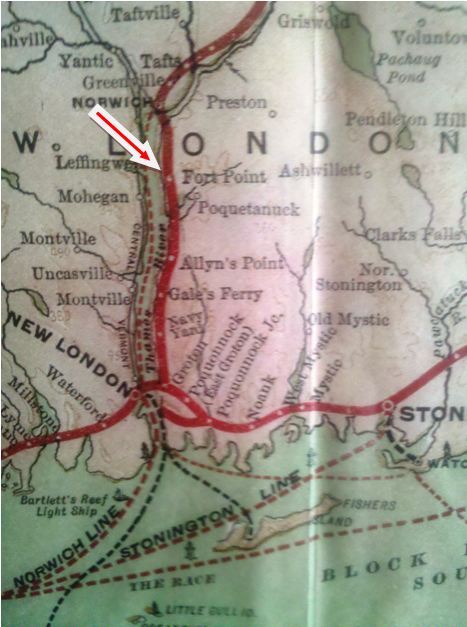
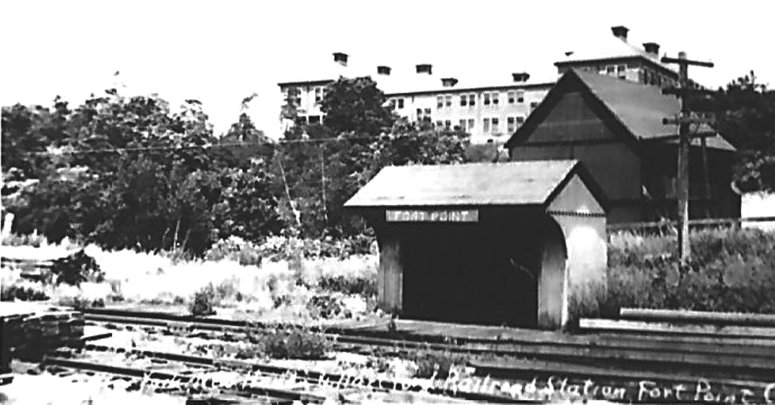
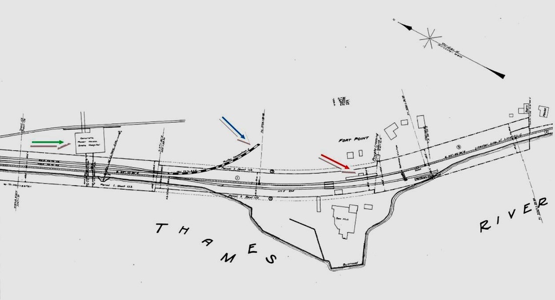
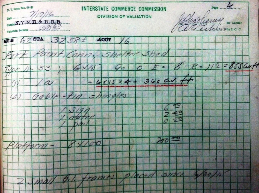
FORT POINT [NYNH&H, 1903]
Station in the town of Preston above POQUETANUCK and below NORWICH on the N&W line. Since this stop is not seen in our 1901 Pathfinder, it seems not to have been established when the 1899 Groton extension opened. Most likely it debuted with the Norwich state hospital that opened late in 1904. It is listed in our 3/2/1913LE timetable with six daily and three Sunday trains stopping in each direction. A branch of the Norwich & Westerly trolley line, which opened in 1906, was built to an interchange with the railroad to ship silica from the Lantern Hill mine in nearby North Stonington and also for coal shipments to the hospital, seen in the distance behind the station at [1]. The 1915 val map at [2] shows the depot at the red arrow, the trolley spur at the blue arrow and the hospital power plant at the green arrow. The ICC field notes at [3] describe the structure here as a 6x15-ft "shelter shed." The 12/04/1903 NYNH&H system map at [4] already shows the stop. Gas railcars took over in the 1920s and as of September, 1928 service to State Hospital was by motor coach, as verified by our 7/27/1930 NETCo timetable. The silica deposits at Lantern Hill were mined, with periods of inactivity, from 1870 to 1994 when the Pequots bought the property to preserve the white quartz cliffs, so-named in the 1800s because they were said traditionally to have shone like a lantern to sailors. When the trolley line closed in 1922, investors looking to operate the mine reportedly bought up the trackage from the mine back to FORT POINT to retain the interchange with the NYNH&H. We do not know whether the Silica Railway and Transportation Co. ever opened before its charter expired. [REFS: HDC/06/10/1871/06; HDC/12/30/1872/04; HC/12/09/1904/02; NLD/10/29/1915/02; HC/02/07/1929/02; HC/08/31/1967/27; NYT/02/21/1995/B6; K108 [rev020914]
Station in the town of Preston above POQUETANUCK and below NORWICH on the N&W line. Since this stop is not seen in our 1901 Pathfinder, it seems not to have been established when the 1899 Groton extension opened. Most likely it debuted with the Norwich state hospital that opened late in 1904. It is listed in our 3/2/1913LE timetable with six daily and three Sunday trains stopping in each direction. A branch of the Norwich & Westerly trolley line, which opened in 1906, was built to an interchange with the railroad to ship silica from the Lantern Hill mine in nearby North Stonington and also for coal shipments to the hospital, seen in the distance behind the station at [1]. The 1915 val map at [2] shows the depot at the red arrow, the trolley spur at the blue arrow and the hospital power plant at the green arrow. The ICC field notes at [3] describe the structure here as a 6x15-ft "shelter shed." The 12/04/1903 NYNH&H system map at [4] already shows the stop. Gas railcars took over in the 1920s and as of September, 1928 service to State Hospital was by motor coach, as verified by our 7/27/1930 NETCo timetable. The silica deposits at Lantern Hill were mined, with periods of inactivity, from 1870 to 1994 when the Pequots bought the property to preserve the white quartz cliffs, so-named in the 1800s because they were said traditionally to have shone like a lantern to sailors. When the trolley line closed in 1922, investors looking to operate the mine reportedly bought up the trackage from the mine back to FORT POINT to retain the interchange with the NYNH&H. We do not know whether the Silica Railway and Transportation Co. ever opened before its charter expired. [REFS: HDC/06/10/1871/06; HDC/12/30/1872/04; HC/12/09/1904/02; NLD/10/29/1915/02; HC/02/07/1929/02; HC/08/31/1967/27; NYT/02/21/1995/B6; K108 [rev020914]

|

|

|
FRANKLIN [NLW&P, 1849; depot, 1851]
The photo at middle is from Woodruff's 1941 history of the NLW&P and his captioning is instructive. It says that the station was built at a cost of $200 in 1851, two years after the road opened to Willimantic, and that the shot was taken in 1936 after 85 years of service. We do not know exactly how customary it was that a lighted newspaper torch was used to flag down trains at night, as Woodward claims, but we have heard similar incendiary claims elsewhere. The 1854NL map shows the location in that year. The depot is not listed as still standing according to John Roy's 2007 Field Guide. [REFS: R53]
The photo at middle is from Woodruff's 1941 history of the NLW&P and his captioning is instructive. It says that the station was built at a cost of $200 in 1851, two years after the road opened to Willimantic, and that the shot was taken in 1936 after 85 years of service. We do not know exactly how customary it was that a lighted newspaper torch was used to flag down trains at night, as Woodward claims, but we have heard similar incendiary claims elsewhere. The 1854NL map shows the location in that year. The depot is not listed as still standing according to John Roy's 2007 Field Guide. [REFS: R53]
|
|
|
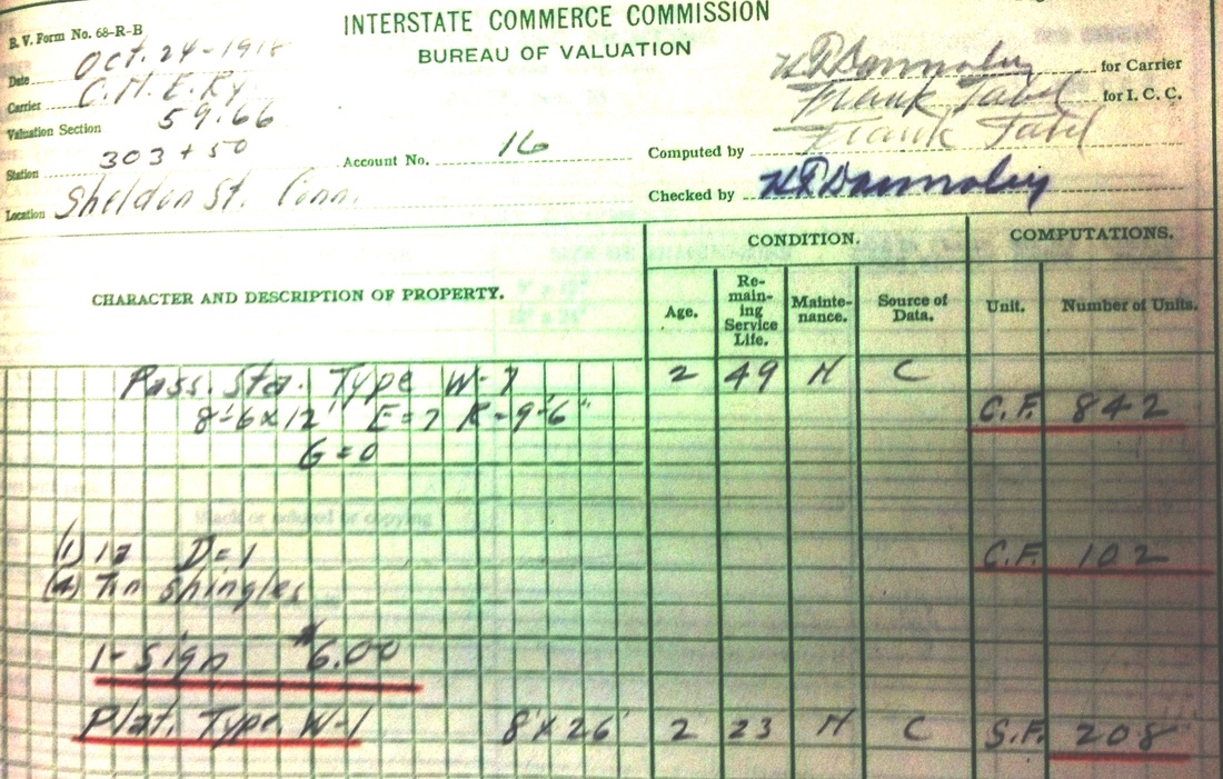
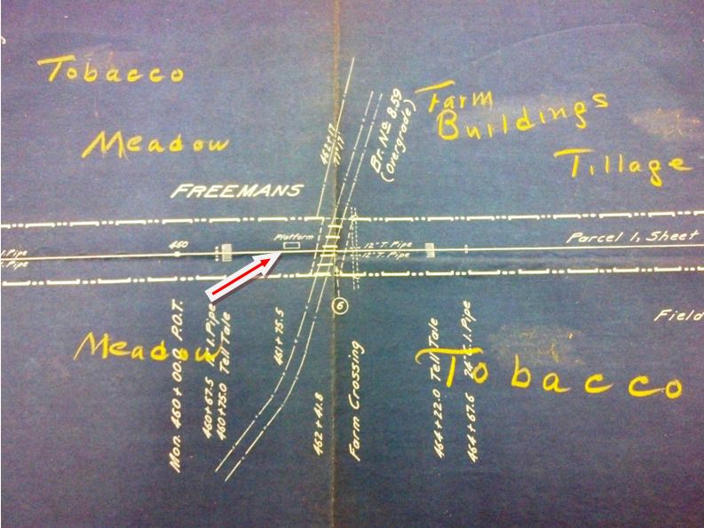
FREEMANS [CNE, 1903]
This stop was in the town of Suffield about a mile north of the WEST SUFFIELD station. The 10/9/1929 PUC photo at [1] shows the SHELDON STREET structure at that time. The newspaper said late in 1902 that the CNE had decided to establish flag stations on the Springfield branch, here and at SHELDON STREET, as well as in Feeding Hills, Mass. "for the better accommodation of the public." The article went on to say that "comfortable shelters will be built, and would-be patrons will be obliged to 'work the flag' themselves" to let the train crew know that there was someone waiting to board. The stop at SHELDON STREET debuted in March, 1903, probably the same as here but CNE volumes at the Baker Library show a February, 1903 expense of a mere $23 for a "low platform" at both locations. The ICC's FREEMANS notes (not shown) say there was only "a platform and station sign" here on 11/19/1917 and the 1916 val map at [3] shows only a platform in the southwest quadrant of the overhead bridge crossing. We suspect that a structure like SHELDON STREET stood here but have no photos and do not know its fate if it ever existed. [REFS: SR/11/17/1902/08; SR/03/03/1903/10; B258.230; SL23.4.7][rev020417]
This stop was in the town of Suffield about a mile north of the WEST SUFFIELD station. The 10/9/1929 PUC photo at [1] shows the SHELDON STREET structure at that time. The newspaper said late in 1902 that the CNE had decided to establish flag stations on the Springfield branch, here and at SHELDON STREET, as well as in Feeding Hills, Mass. "for the better accommodation of the public." The article went on to say that "comfortable shelters will be built, and would-be patrons will be obliged to 'work the flag' themselves" to let the train crew know that there was someone waiting to board. The stop at SHELDON STREET debuted in March, 1903, probably the same as here but CNE volumes at the Baker Library show a February, 1903 expense of a mere $23 for a "low platform" at both locations. The ICC's FREEMANS notes (not shown) say there was only "a platform and station sign" here on 11/19/1917 and the 1916 val map at [3] shows only a platform in the southwest quadrant of the overhead bridge crossing. We suspect that a structure like SHELDON STREET stood here but have no photos and do not know its fate if it ever existed. [REFS: SR/11/17/1902/08; SR/03/03/1903/10; B258.230; SL23.4.7][rev020417]