Track 12: CT Passenger Stations, L
See TCS Home Page links for notes, abbreviations, and sources.
Use Track 11 map link to locate stations, rail and trolley lines, and POIs.
Use Track 11 map link to locate stations, rail and trolley lines, and POIs.
LAKE1 [SRR, c1875?]
This stop was about 2.5 miles west of LITCHFIELD in the town of that name. It was not an original stop on the Shepaug RR when it opened in 1872. The first appearance on a timetable that we have seen is 1882 but, in the vague manner of the day, there are hints that trains may have been stopping here at least as early as 1875. No photo.
This stop was about 2.5 miles west of LITCHFIELD in the town of that name. It was not an original stop on the Shepaug RR when it opened in 1872. The first appearance on a timetable that we have seen is 1882 but, in the vague manner of the day, there are hints that trains may have been stopping here at least as early as 1875. No photo.
Dave Peters Collection
|

|
LAKE2 [SRR, 1889]
The railroad commissioners say in their 1889 annual report that "a new shelter station has been erected during the past year at Lake station," and that probably means, as Lord says, this was the second to be built here. A NYNH&H real estate card has 1875 for the build date of this one, but that was probably for the earlier structure. Like other railroads, the SV took advantage of lakes and ponds as sources of winter revenue. Bantam Lake did the honors here. Lord says that tons of the frozen product were stored in a 700x125-ft ice house here that was 30 feet high and was reached by a spur track just north of this station. [REFS: PTH426.1875.18; CRC37.1889.22; D147]
The railroad commissioners say in their 1889 annual report that "a new shelter station has been erected during the past year at Lake station," and that probably means, as Lord says, this was the second to be built here. A NYNH&H real estate card has 1875 for the build date of this one, but that was probably for the earlier structure. Like other railroads, the SV took advantage of lakes and ponds as sources of winter revenue. Bantam Lake did the honors here. Lord says that tons of the frozen product were stored in a 700x125-ft ice house here that was 30 feet high and was reached by a spur track just north of this station. [REFS: PTH426.1875.18; CRC37.1889.22; D147]
|

|
|
East Haven Historical Society
|
East Haven Historical Society
|

|
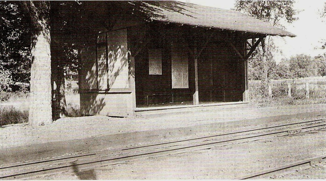
LAKE SALTONSTALL [NH&NL, 1852?]
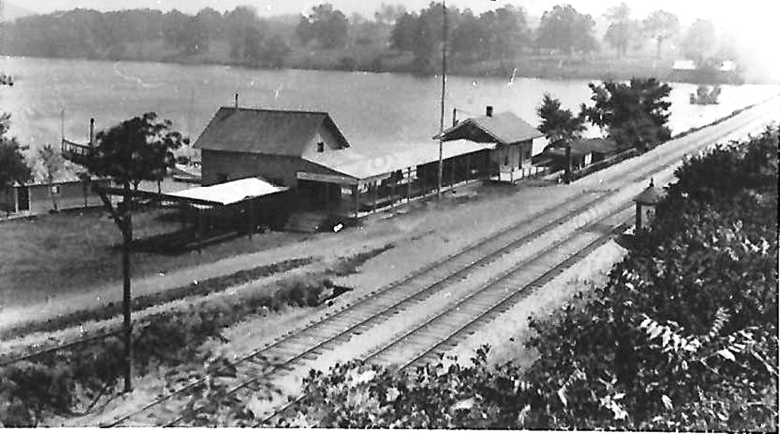
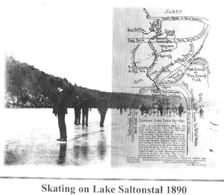
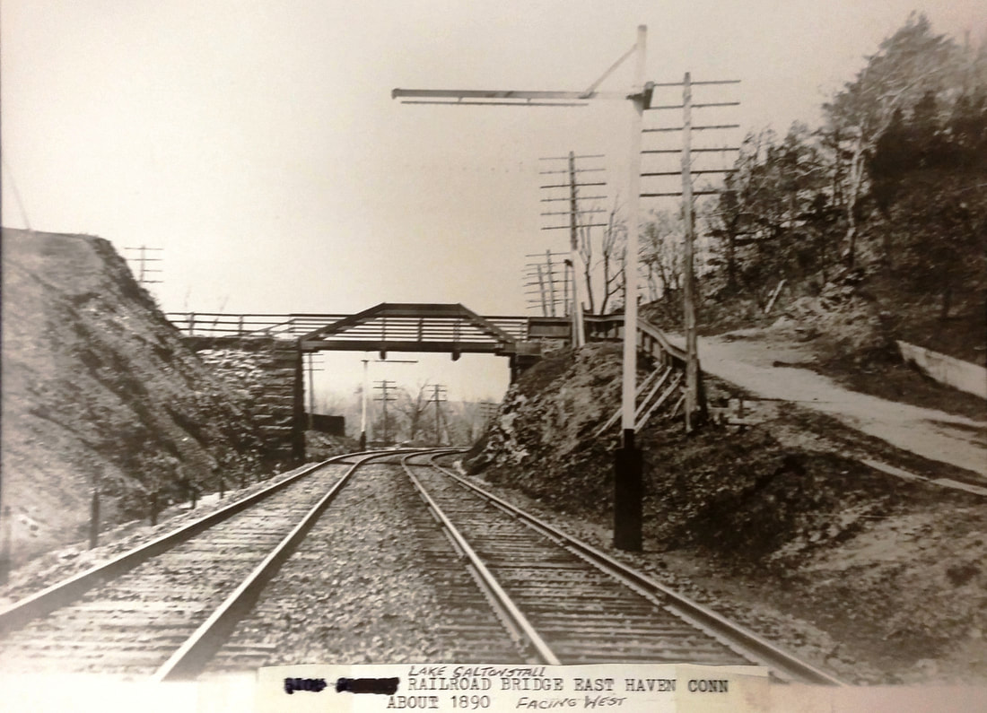
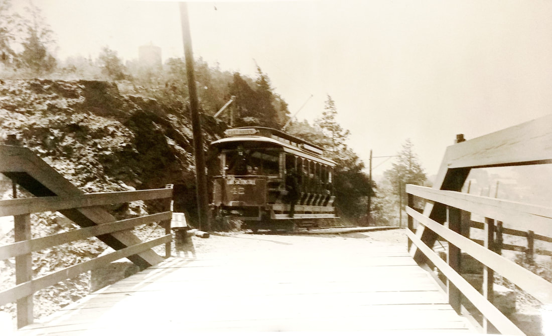
This station was in the town of East Haven at a popular recreational spot near the Branford border. According to Hughes, a platform for ice harvesting from the 'mill pond' was put up when the NH&NL opened in 1852, and by 1856 when the "ice skating craze swept over the country, the cars brought crowds of skaters to the lake." It was then that the Lake Saltonstall name came into use for this body of water. Seasonal "Skating Pond Excursion Trains" are noted in the newspaper on 1/1/1862, twice daily each way " ...as long as the skating on the Lake is good..." The first hint of a depot is in 1875 when a man was killed "... just east of the Saltonstall station, by the night freight..." The view at [1] looks northeast with the station and boat landing on the west shore of the lake; the 1893 map at [2] showing depot on the east side is incorrect. According to the ad at [3], this location was eight minutes walking time from the EAST HAVEN station. Prior to 1878 some Yale-Harvard competitions were held here and the Eli regattas and single-scull races continued into the 1890s. In the winter of 1894, all accommodation trains were stopping here. Nautical high points for this popular body of water were its use in 1880 by Simon Lake for testing of his early submarines and the debut in 1895 of the Electra, the battery-powered boat that carried thousands at the 1893 Columbian Exposition in Chicago. One report says the batteries were charged by wire from the trolley wire; the line that opened in July, 1894 to a terminus at the bridge over the track seen at [4]. People disembarked for the short walk along the access road at right in the photo to get to the boat landing and were taken from there to picnicking and recreational facilities at Glen Cove on the north shore of the lake. In the shot at [5] State Street car #46 poses at the end of the line; note the 1882 water pumping tower at upper left. The year 1896 marked the sudden close when New Haven Water Co. Pres. Eli Whitney announced that Lake Saltonstall would become watershed property, with bathing, boating and picnicking prohibited. Trains ceased stopping and the trolley rails were lifted back to the Green and used instead for the new trolley line down Coe Ave. to Cosey Beach and Momauguin. The snippet from our Track 11 Google Earth map at [6] shows the Lake Saltonstall RR trolley line in orange ending at the railroad bridge on the Regional Water Authority's access road. [REFS: HDC/01/27/1854/02; HDC/01/09/1860/02; NLDC/01/01/1862/02; HDC/10/21/1871/02; MDC/09/21/1875/02; NHER/07/12/1880/04; NHER/10/14/1892/03: track sinks; NHER/01/23/1894/04; NHJC/03/09/1895/04; 7/15/1894revTT: yes; NHER/03/25/1896/01; DIO/05/16/1896/05; 7/01/1896revTT: no; Sarah E. Hughes, History of East Haven, p130][rev011518]
This station was in the town of East Haven at a popular recreational spot near the Branford border. According to Hughes, a platform for ice harvesting from the 'mill pond' was put up when the NH&NL opened in 1852, and by 1856 when the "ice skating craze swept over the country, the cars brought crowds of skaters to the lake." It was then that the Lake Saltonstall name came into use for this body of water. Seasonal "Skating Pond Excursion Trains" are noted in the newspaper on 1/1/1862, twice daily each way " ...as long as the skating on the Lake is good..." The first hint of a depot is in 1875 when a man was killed "... just east of the Saltonstall station, by the night freight..." The view at [1] looks northeast with the station and boat landing on the west shore of the lake; the 1893 map at [2] showing depot on the east side is incorrect. According to the ad at [3], this location was eight minutes walking time from the EAST HAVEN station. Prior to 1878 some Yale-Harvard competitions were held here and the Eli regattas and single-scull races continued into the 1890s. In the winter of 1894, all accommodation trains were stopping here. Nautical high points for this popular body of water were its use in 1880 by Simon Lake for testing of his early submarines and the debut in 1895 of the Electra, the battery-powered boat that carried thousands at the 1893 Columbian Exposition in Chicago. One report says the batteries were charged by wire from the trolley wire; the line that opened in July, 1894 to a terminus at the bridge over the track seen at [4]. People disembarked for the short walk along the access road at right in the photo to get to the boat landing and were taken from there to picnicking and recreational facilities at Glen Cove on the north shore of the lake. In the shot at [5] State Street car #46 poses at the end of the line; note the 1882 water pumping tower at upper left. The year 1896 marked the sudden close when New Haven Water Co. Pres. Eli Whitney announced that Lake Saltonstall would become watershed property, with bathing, boating and picnicking prohibited. Trains ceased stopping and the trolley rails were lifted back to the Green and used instead for the new trolley line down Coe Ave. to Cosey Beach and Momauguin. The snippet from our Track 11 Google Earth map at [6] shows the Lake Saltonstall RR trolley line in orange ending at the railroad bridge on the Regional Water Authority's access road. [REFS: HDC/01/27/1854/02; HDC/01/09/1860/02; NLDC/01/01/1862/02; HDC/10/21/1871/02; MDC/09/21/1875/02; NHER/07/12/1880/04; NHER/10/14/1892/03: track sinks; NHER/01/23/1894/04; NHJC/03/09/1895/04; 7/15/1894revTT: yes; NHER/03/25/1896/01; DIO/05/16/1896/05; 7/01/1896revTT: no; Sarah E. Hughes, History of East Haven, p130][rev011518]

|
|
|
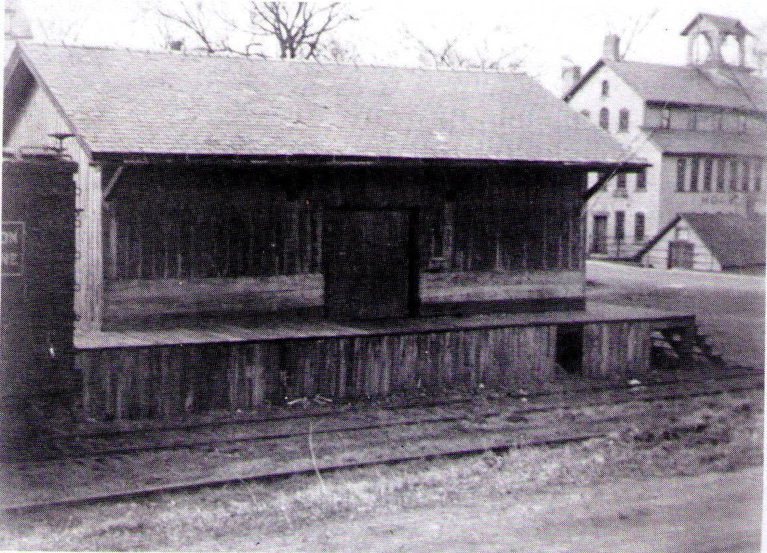
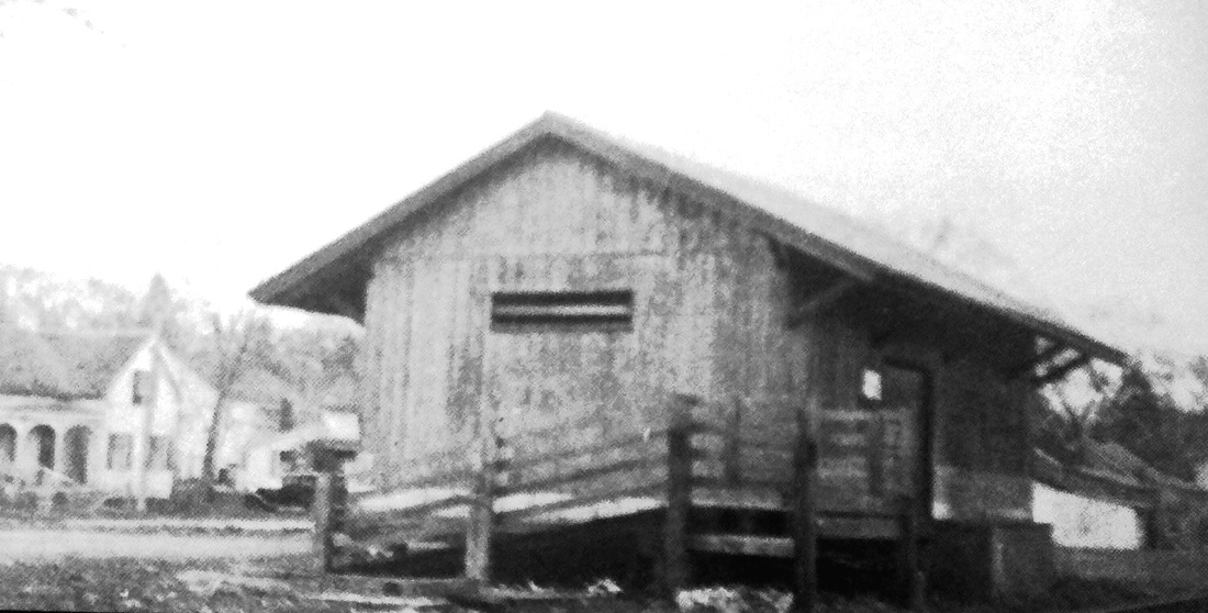
LAKEVILLE1 [CW, 1871]
This station was in the town of Salisbury. The photos shown above are the freight depots here [left] and at Salisbury [right] built by G.H. Bundy of Lakeville who was also responsible for the CANAAN2 union station. While we have no photos of LAKEVILLE1 or SALISBURY1, our thinking is that Bundy also utilized the simple gable style for the two passenger stations, which were said in an 1872 newspaper article to be "built so nearly alike that the difference between the two is scarcely perceptible." This stop was established when the CW opened in 1871 and the newspaper said in November that the "the grading for the passenger depot in Lakeville, has been executed in a very creditable manner by the employees of the Davis ore bed, who were employed by the railroad company for that work. The freight depot is finished and the passenger depot is progressing to a rapid completion, the slate roof being on and all enclosed." The 1874 map at left shows the passenger station at our red arrow and the freight depot at the blue arrow. A 12/08/1871 article described the style of this passenger station, and presumably SALISBURY1 as well, "the depot of divorcement" inasmuch as there was no way to go from the men's to the women's waiting rooms without exiting the building. That arrangement is probably explained by the 1872 article that said that there was "a commodious ladies' parlor at one end, and an equally large and neatly arranged waiting room for gentlemen at the other, with a convenient office for the agents and a room for baggage between the two..." Further details reveal that "the walls are made of hard finish, with very wide and elegant cornice plaster mouldings decorating the high ceilings." Whether Bundy designed, or just built, these somewhat opulent passenger facilities is not known. The 1880 NY&NE appraisal of CW assets said this station was in good condition and valued it at $1500, equal to SALISBURY, BLOOMFIELD, CANTON and other CW passenger structures. What happened to LAKEVILLE1 -- fire is the usual culprit -- has not been discovered but the next station came in 1891. A final interesting note about the location of the passenger station is that it was once the site of the dwelling house of Revolutionary War patriot Ethan Allen, his well still being extant in 1886. REFS: CWN/11/17/1871/02; CWN/12/08/1871/02; WH/12/15/1871/00; CWN/01/19/1872 /02; HDC/07/ 02/1886/04][rev061513]
This station was in the town of Salisbury. The photos shown above are the freight depots here [left] and at Salisbury [right] built by G.H. Bundy of Lakeville who was also responsible for the CANAAN2 union station. While we have no photos of LAKEVILLE1 or SALISBURY1, our thinking is that Bundy also utilized the simple gable style for the two passenger stations, which were said in an 1872 newspaper article to be "built so nearly alike that the difference between the two is scarcely perceptible." This stop was established when the CW opened in 1871 and the newspaper said in November that the "the grading for the passenger depot in Lakeville, has been executed in a very creditable manner by the employees of the Davis ore bed, who were employed by the railroad company for that work. The freight depot is finished and the passenger depot is progressing to a rapid completion, the slate roof being on and all enclosed." The 1874 map at left shows the passenger station at our red arrow and the freight depot at the blue arrow. A 12/08/1871 article described the style of this passenger station, and presumably SALISBURY1 as well, "the depot of divorcement" inasmuch as there was no way to go from the men's to the women's waiting rooms without exiting the building. That arrangement is probably explained by the 1872 article that said that there was "a commodious ladies' parlor at one end, and an equally large and neatly arranged waiting room for gentlemen at the other, with a convenient office for the agents and a room for baggage between the two..." Further details reveal that "the walls are made of hard finish, with very wide and elegant cornice plaster mouldings decorating the high ceilings." Whether Bundy designed, or just built, these somewhat opulent passenger facilities is not known. The 1880 NY&NE appraisal of CW assets said this station was in good condition and valued it at $1500, equal to SALISBURY, BLOOMFIELD, CANTON and other CW passenger structures. What happened to LAKEVILLE1 -- fire is the usual culprit -- has not been discovered but the next station came in 1891. A final interesting note about the location of the passenger station is that it was once the site of the dwelling house of Revolutionary War patriot Ethan Allen, his well still being extant in 1886. REFS: CWN/11/17/1871/02; CWN/12/08/1871/02; WH/12/15/1871/00; CWN/01/19/1872 /02; HDC/07/ 02/1886/04][rev061513]
|

|

|
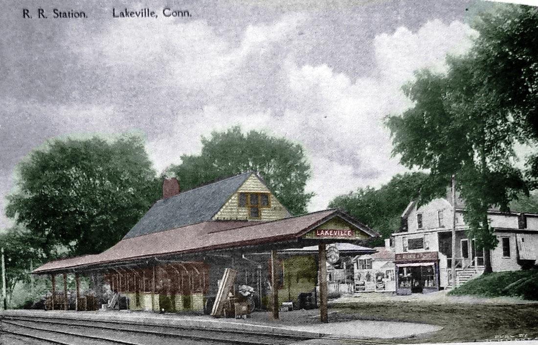
LAKEVILLE2 [CNE&W, 1891]
Nimke and others say this station was put up in 1891 and it does look like the extant depot at Stanfordville, NY, ascribed to the same year. It certainly does not look like anything the fledgling CW would have built in 1871 yet the nomination form for the 1996 NRHP designation says it was the original station in this village and some others have wondered also. Arguing against that is the 1917 floor plan at lower left that shows that this does not have the separate men's and women's waiting rooms that the 12/17/1871 "depot of divorcement" article described. Accepting this as the second station still however gives us no clue what happened to the first one, since no mentions have been found in the newspapers or annual reports of the railroads or the railroad commissioners. CNE passenger service ended in 1927 and in 1939 this structure was used for general freight while the old freight depot was to handle Community Service goods exclusively. LAKEVILLE2 thereafter became the property of the town and has seen a number of commercial tenants, including radio station WQQQ, over the years. [REFS: CWN/12/08/1871/02; LJ/03/16/1939/05; D48,49,73; N3.97; R61][rev061513]
Nimke and others say this station was put up in 1891 and it does look like the extant depot at Stanfordville, NY, ascribed to the same year. It certainly does not look like anything the fledgling CW would have built in 1871 yet the nomination form for the 1996 NRHP designation says it was the original station in this village and some others have wondered also. Arguing against that is the 1917 floor plan at lower left that shows that this does not have the separate men's and women's waiting rooms that the 12/17/1871 "depot of divorcement" article described. Accepting this as the second station still however gives us no clue what happened to the first one, since no mentions have been found in the newspapers or annual reports of the railroads or the railroad commissioners. CNE passenger service ended in 1927 and in 1939 this structure was used for general freight while the old freight depot was to handle Community Service goods exclusively. LAKEVILLE2 thereafter became the property of the town and has seen a number of commercial tenants, including radio station WQQQ, over the years. [REFS: CWN/12/08/1871/02; LJ/03/16/1939/05; D48,49,73; N3.97; R61][rev061513]

LANESVILLE AND STILL RIVER1 [HRR, c1865]
While the RRMs use the original name of LANESVILLE exclusively, the railroads changed it to the dual name in 1888 and used that until 1914 when it became simply STILL RIVER. This is a situation, unique we think in the state, where two depot structures had three names and served as stations in four distinct locations and, if simplification is even possible, we have consolidated all the entries here to try to trace this unique evolution. First of all, this was not an original passenger stop on the HRR and so it does not appear on the various timetables we have through 1864, but by 1868 the railroad commissioners were ordering repairs to a depot at LANESVILLE and it does appear as a flag stop on our 1883TT. Late in 1885 the newspaper reported that "the Housatonic railroad company are to move the Lanesville station up near the silica mills in order to save stopping their trains twice, for all freight trains have to stop at both places." This appears to mean that all trains were making an additional freight stop at the mills operated by the Bridgeport Wood Finishing Co., a flourishing manufacturer of paints and wood sealants located about a quarter mile north. The building of a road for the public to get to the new location came at municipal expense and, though the newspaper commented "Our taxes are heavy enough now," the prosperity of BWF as a major local employer seems to have won the day. The abandonment of the original location was permitted by the commissioners in 1888. We lucked out in finding the New Milford map of that very year showing the 'Flag Station' still at the first location. According to the newspaper, the old depot itself was moved north, and it is seen in the BWF ad in our next entry. [REFS: RRC6.11 (5/16/1868); B814: $75 toward new depot(?); CWN/11/29/1872/02; 1883TT; CWN/10/14/1885/03; RRC19.135 (7/30/1888); NMG/09/07/1888/02][rev081413]
While the RRMs use the original name of LANESVILLE exclusively, the railroads changed it to the dual name in 1888 and used that until 1914 when it became simply STILL RIVER. This is a situation, unique we think in the state, where two depot structures had three names and served as stations in four distinct locations and, if simplification is even possible, we have consolidated all the entries here to try to trace this unique evolution. First of all, this was not an original passenger stop on the HRR and so it does not appear on the various timetables we have through 1864, but by 1868 the railroad commissioners were ordering repairs to a depot at LANESVILLE and it does appear as a flag stop on our 1883TT. Late in 1885 the newspaper reported that "the Housatonic railroad company are to move the Lanesville station up near the silica mills in order to save stopping their trains twice, for all freight trains have to stop at both places." This appears to mean that all trains were making an additional freight stop at the mills operated by the Bridgeport Wood Finishing Co., a flourishing manufacturer of paints and wood sealants located about a quarter mile north. The building of a road for the public to get to the new location came at municipal expense and, though the newspaper commented "Our taxes are heavy enough now," the prosperity of BWF as a major local employer seems to have won the day. The abandonment of the original location was permitted by the commissioners in 1888. We lucked out in finding the New Milford map of that very year showing the 'Flag Station' still at the first location. According to the newspaper, the old depot itself was moved north, and it is seen in the BWF ad in our next entry. [REFS: RRC6.11 (5/16/1868); B814: $75 toward new depot(?); CWN/11/29/1872/02; 1883TT; CWN/10/14/1885/03; RRC19.135 (7/30/1888); NMG/09/07/1888/02][rev081413]
|

|
|
LANESVILLE AND STILL RIVER2 [HRR, 1888]
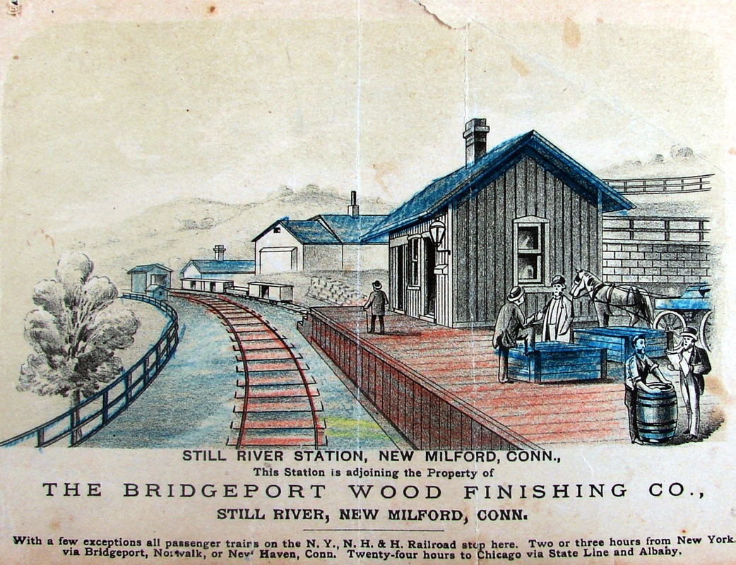
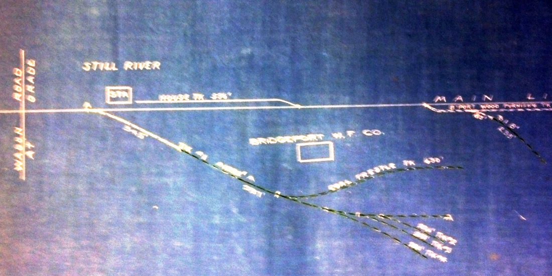
The 1888 site for the old LANESVILLE depot structure was closer to the confluence of the Still and Housatonic Rivers where the factory had relocated from its namesake city in 1881 to take advantage of the water power of the Great Falls [click here]. The 1893 topo map at [2] shows the village of Lanesville and the red arrow shows the new location of the station. Arguments that included an intended bridge over the track at the new site also supported the relocation as a safety move, but it is unclear to us how that would have been true unless the old crossing was eliminated. It seems as though that was never done and the bridge wasn't built either, but the access road was put in and by December, 1888 the Lanesville correspondent for the New Milford Gazette said "The depot has been moved to the Silica works to the regret of many inhabitants living around here." A more formal HRR announcement said that the old location would now be known as Lanesville siding and would be used for train meets, some car-load freight, and mail service for the village post office, while the relocated station would handle passenger traffic, the area's substantial milk shipments, and, of course, BWF. A 1914 newspaper article would later say that this depot had been "constructed from a freight car or two." That may mean either from the lumber or, more literally, fashioned from a car body which may be possibly be seen in this structure's simple lines, uncharacteristic of other HRR depots. In recognition of the relocation, HRR timetables begin to call this stop LANESVILLE AND STILL RIVER and this carried over to the NYNH&H in 1892, the era of the BWF ad at [1], which is from a city directory and is the only representation we have of this depot. Touting the proximity of the factory to the railroad, the sketch looks north and shows the station on the east side of the track, flanked by BWF buildings. The covered bridge in the distance is for the railroad's crossing of the Still River. The undated but more authoritative blueprint map at [3] shows the depot and the BWF sidings. With newspapers giving some unhelpfully inconsistent date information, a 1:00 a.m. fire, probably on 8/15/1904, was reported to have damaged the interior and the north part of the station after a semaphore signal lantern exploded. BWF workers living on the factory property came with a hose from a company hydrant and saved the structure, with just the south part used as the depot thereafter. The loss was stated variously as four hundred to "several hundred" dollars. [REFS: RRC6.11 (5/16/1868); 1883TT; CWN/10/14/1885/03; RRC19.135 (7/30/1888); NMG/09/14/1888/04; NMG/10/05/1888/02; NMG/12/07/1888/02,supp; NBE/12/14/1888/01; NBE/04/20/1894/07: store removed; NBE/06/26/1896/05: 40-50 milk cans per day; HC/08/16/1904/15; DEN/08/18/1904/10; NMG/08/19/1904/03; NBE/08/19/1904/08; 1923TT][rev030118]
The 1888 site for the old LANESVILLE depot structure was closer to the confluence of the Still and Housatonic Rivers where the factory had relocated from its namesake city in 1881 to take advantage of the water power of the Great Falls [click here]. The 1893 topo map at [2] shows the village of Lanesville and the red arrow shows the new location of the station. Arguments that included an intended bridge over the track at the new site also supported the relocation as a safety move, but it is unclear to us how that would have been true unless the old crossing was eliminated. It seems as though that was never done and the bridge wasn't built either, but the access road was put in and by December, 1888 the Lanesville correspondent for the New Milford Gazette said "The depot has been moved to the Silica works to the regret of many inhabitants living around here." A more formal HRR announcement said that the old location would now be known as Lanesville siding and would be used for train meets, some car-load freight, and mail service for the village post office, while the relocated station would handle passenger traffic, the area's substantial milk shipments, and, of course, BWF. A 1914 newspaper article would later say that this depot had been "constructed from a freight car or two." That may mean either from the lumber or, more literally, fashioned from a car body which may be possibly be seen in this structure's simple lines, uncharacteristic of other HRR depots. In recognition of the relocation, HRR timetables begin to call this stop LANESVILLE AND STILL RIVER and this carried over to the NYNH&H in 1892, the era of the BWF ad at [1], which is from a city directory and is the only representation we have of this depot. Touting the proximity of the factory to the railroad, the sketch looks north and shows the station on the east side of the track, flanked by BWF buildings. The covered bridge in the distance is for the railroad's crossing of the Still River. The undated but more authoritative blueprint map at [3] shows the depot and the BWF sidings. With newspapers giving some unhelpfully inconsistent date information, a 1:00 a.m. fire, probably on 8/15/1904, was reported to have damaged the interior and the north part of the station after a semaphore signal lantern exploded. BWF workers living on the factory property came with a hose from a company hydrant and saved the structure, with just the south part used as the depot thereafter. The loss was stated variously as four hundred to "several hundred" dollars. [REFS: RRC6.11 (5/16/1868); 1883TT; CWN/10/14/1885/03; RRC19.135 (7/30/1888); NMG/09/14/1888/04; NMG/10/05/1888/02; NMG/12/07/1888/02,supp; NBE/12/14/1888/01; NBE/04/20/1894/07: store removed; NBE/06/26/1896/05: 40-50 milk cans per day; HC/08/16/1904/15; DEN/08/18/1904/10; NMG/08/19/1904/03; NBE/08/19/1904/08; 1923TT][rev030118]
|
|
|
UConn Archives & Special Colls
LANESVILLE AND STILL RIVER3 [NYNH&H, 1905]
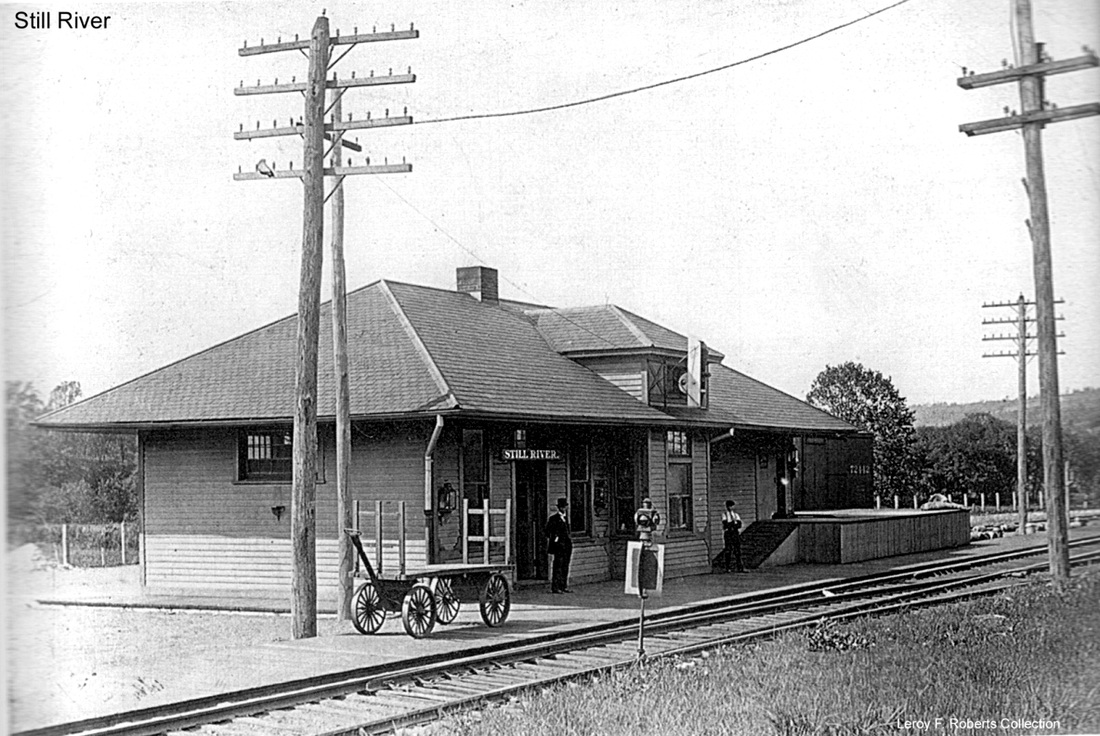
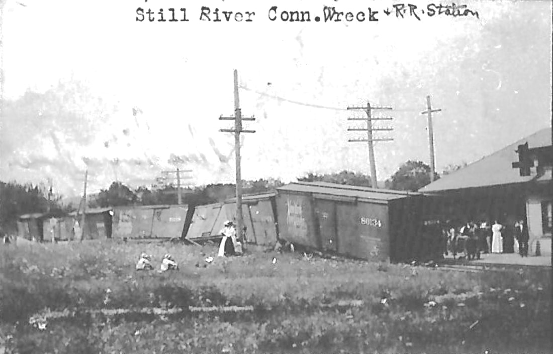
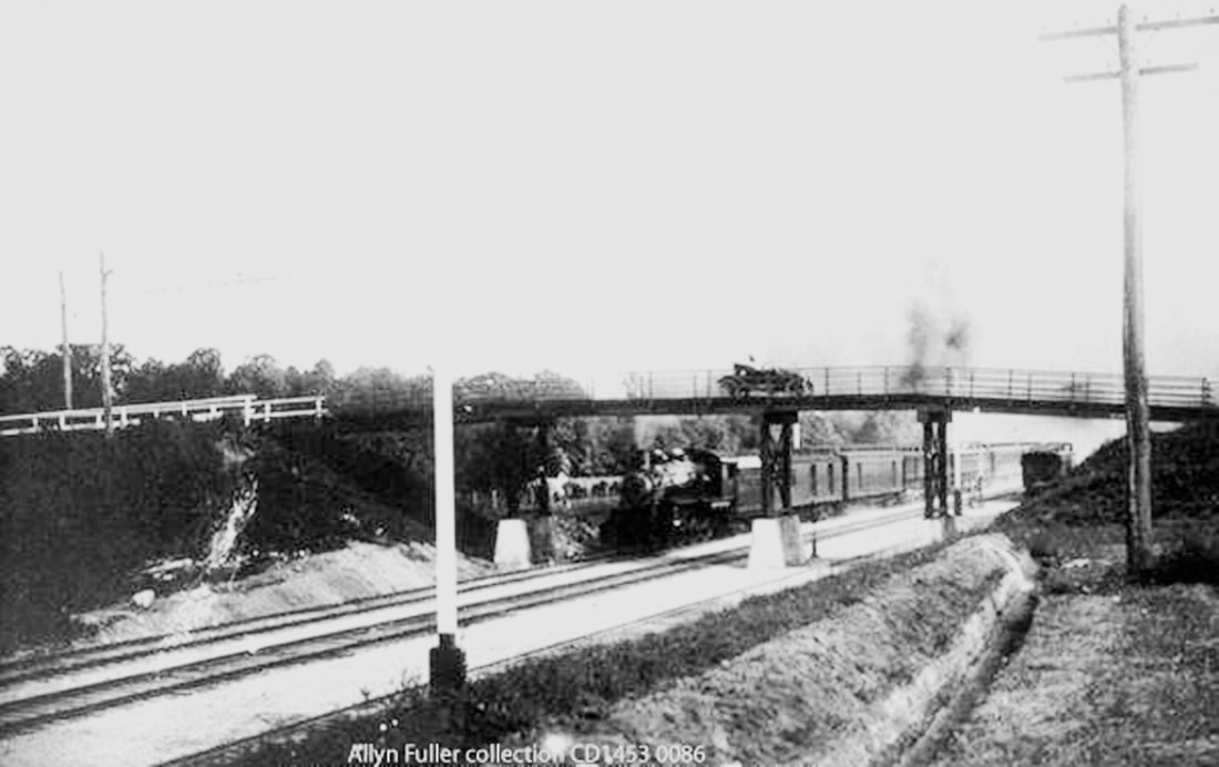
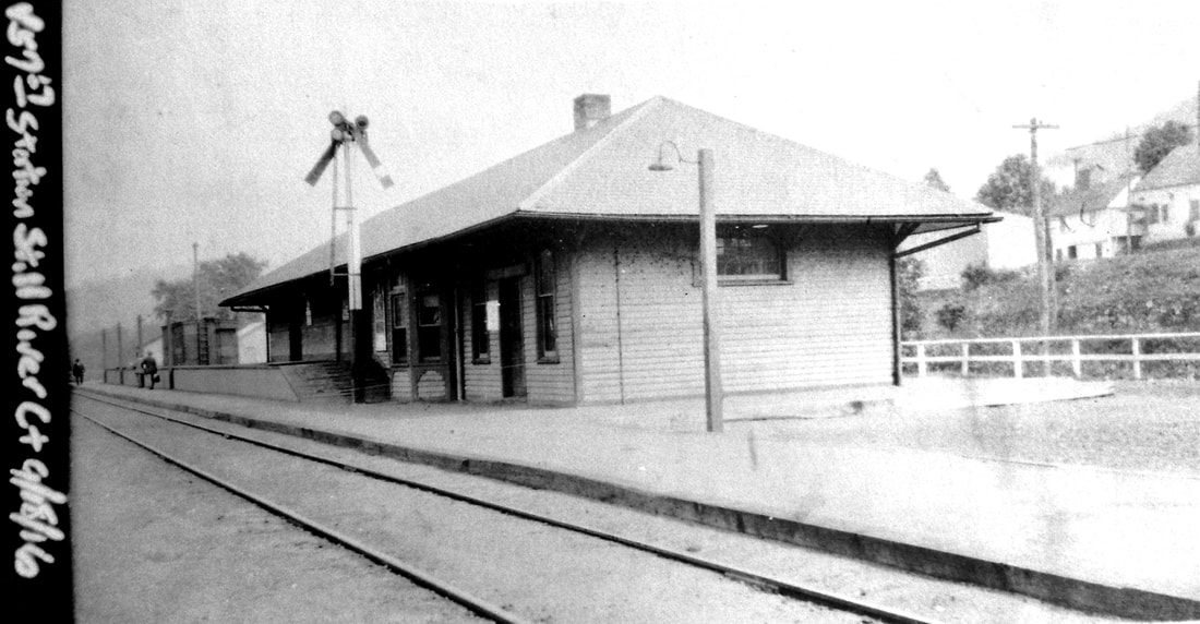
This front-dormered, hip-roofed combination station, with small freight platform and stub-ended siding, was reported by the Newtown Bee to be opened for business on 1/20/1905. As seen at [1] around opening time, it is apparent that it was on the west side of the Berkshire Division track with the flat terrain in the background, in stark contrast to hilly area seen behind the earlier station which was on the east side. Locals were very happy with the new depot which was said to measure 58x23 feet, with large airy waiting room for the public, "... running water provided for the closets...," and a large office for the agreeable agent M.T. Ryan and his wife as assistant. Ryan was last stationed in Monroe before that agency was closed and the depot abandoned in 1895: see MONROE2. In May, 1905, when there was wrangling yet again over highway improvements, it led to the comment that the Consolidated road had "spent thousands of dollars in giving us one of the nicest depots of its kind to be found anywhere on the Berkshire Division" and town roads should be built to better serve it. The 8/15/1907 wreck in the photo at [2] corroborates the appearance of the depot at that time. By 1913, the railroad's annual reports mention that a double-tracking and realignment project through Brookfield and New Milford was to include the "remodeling and relocation of the present Still River station," which we cover in our next entry. The 1912 real estate map at [3] shows the location of the 1905 station, the layout of the grounds, and the coming new alignment passing right through the depot, hence the reason it had to be moved. The shot at [4] shows a train going under the Lanesville Rd. overpass that was part of the improvements of 1913. The photo shows a rail car parked on the old main just beyond the bridge where the 1905 depot stood. The highway overpass was probably removed when today's Still River Drive was built and dwindling rail traffic did not justify a new bridge. A freak auto mishap in 1975 reported a car dangling two-thirds of the way off the side of the bridge. No one was injured but the young driver was fined as going too fast for the wet road conditions. Penn Central was contacted to replace the guardrail that was knocked to the tracks below. [REFS: NBE/09/23/1904/08; NBE/12/02/1904/05; NBE/01/20/1905/06; CRC53.1905.26; NHAR35.1905.7; NMG/05/26/1905/04; DEN/08/15/1907/04; NHAR42.1913.11; NHAR43.1914.21; HC/11/09/1974/28C; HC/05/14/ 1975/51D][rev022318]
This front-dormered, hip-roofed combination station, with small freight platform and stub-ended siding, was reported by the Newtown Bee to be opened for business on 1/20/1905. As seen at [1] around opening time, it is apparent that it was on the west side of the Berkshire Division track with the flat terrain in the background, in stark contrast to hilly area seen behind the earlier station which was on the east side. Locals were very happy with the new depot which was said to measure 58x23 feet, with large airy waiting room for the public, "... running water provided for the closets...," and a large office for the agreeable agent M.T. Ryan and his wife as assistant. Ryan was last stationed in Monroe before that agency was closed and the depot abandoned in 1895: see MONROE2. In May, 1905, when there was wrangling yet again over highway improvements, it led to the comment that the Consolidated road had "spent thousands of dollars in giving us one of the nicest depots of its kind to be found anywhere on the Berkshire Division" and town roads should be built to better serve it. The 8/15/1907 wreck in the photo at [2] corroborates the appearance of the depot at that time. By 1913, the railroad's annual reports mention that a double-tracking and realignment project through Brookfield and New Milford was to include the "remodeling and relocation of the present Still River station," which we cover in our next entry. The 1912 real estate map at [3] shows the location of the 1905 station, the layout of the grounds, and the coming new alignment passing right through the depot, hence the reason it had to be moved. The shot at [4] shows a train going under the Lanesville Rd. overpass that was part of the improvements of 1913. The photo shows a rail car parked on the old main just beyond the bridge where the 1905 depot stood. The highway overpass was probably removed when today's Still River Drive was built and dwindling rail traffic did not justify a new bridge. A freak auto mishap in 1975 reported a car dangling two-thirds of the way off the side of the bridge. No one was injured but the young driver was fined as going too fast for the wet road conditions. Penn Central was contacted to replace the guardrail that was knocked to the tracks below. [REFS: NBE/09/23/1904/08; NBE/12/02/1904/05; NBE/01/20/1905/06; CRC53.1905.26; NHAR35.1905.7; NMG/05/26/1905/04; DEN/08/15/1907/04; NHAR42.1913.11; NHAR43.1914.21; HC/11/09/1974/28C; HC/05/14/ 1975/51D][rev022318]
National Archives
|
|
Columbia University
|

|
New Milford Historical Society
|
|
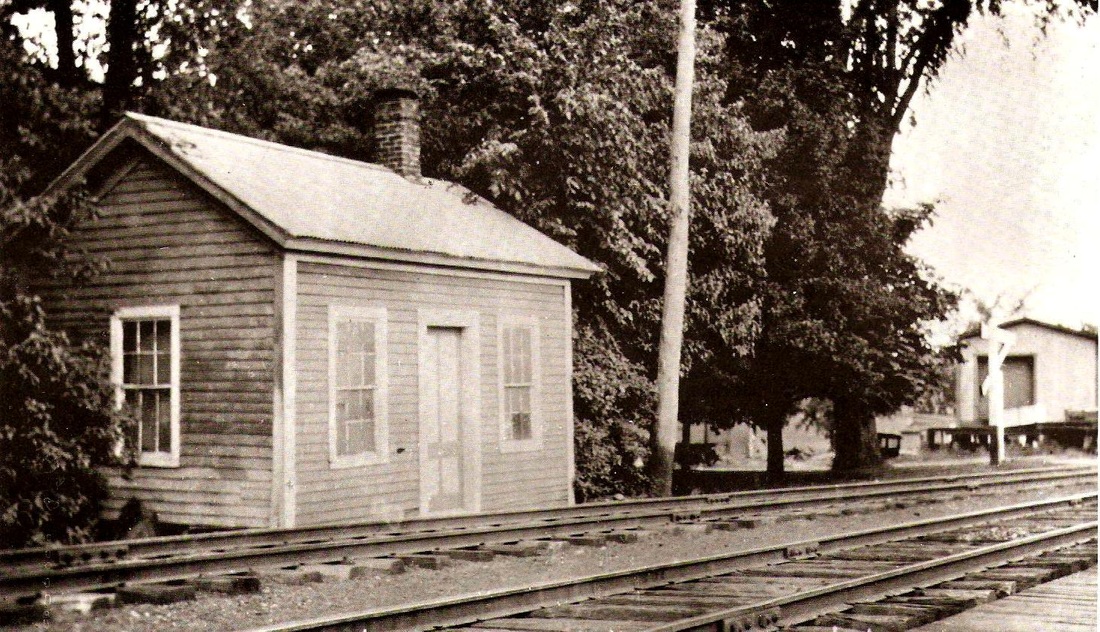
LANESVILLE AND STILL RIVER4 [NYNH&H, 1914]
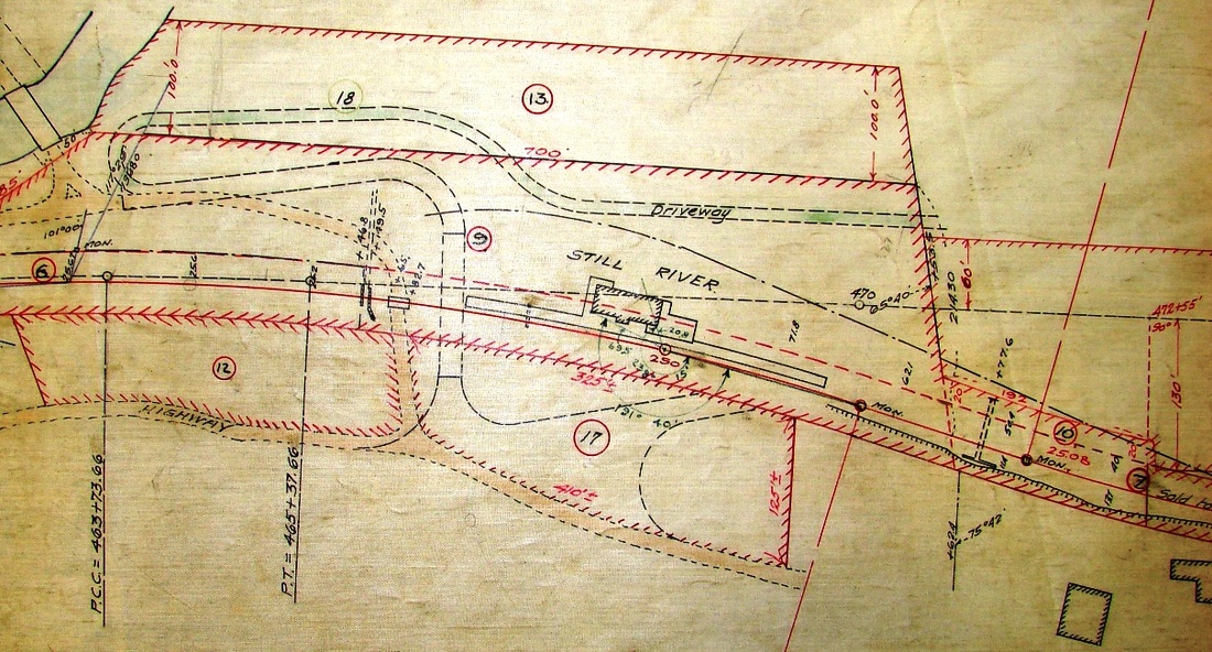
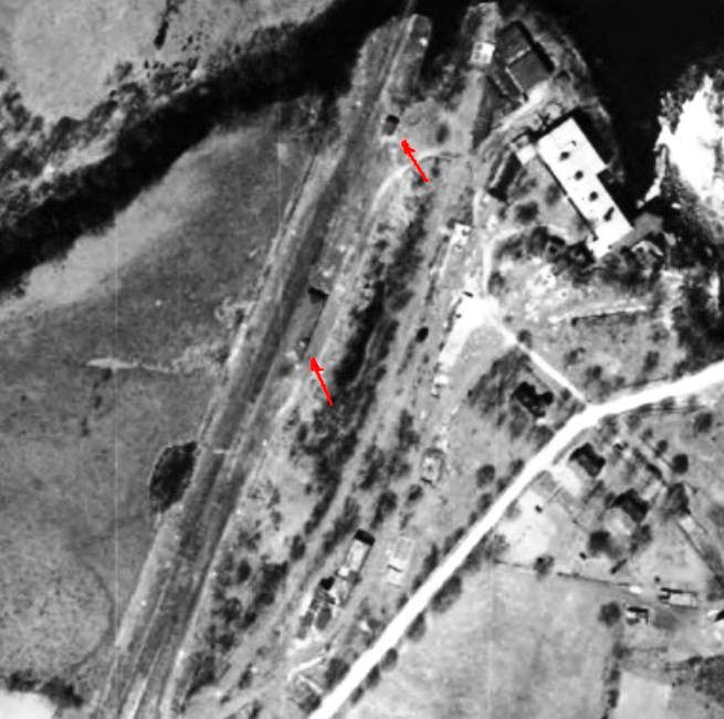
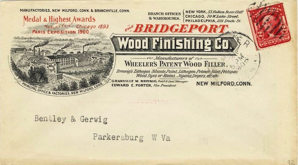
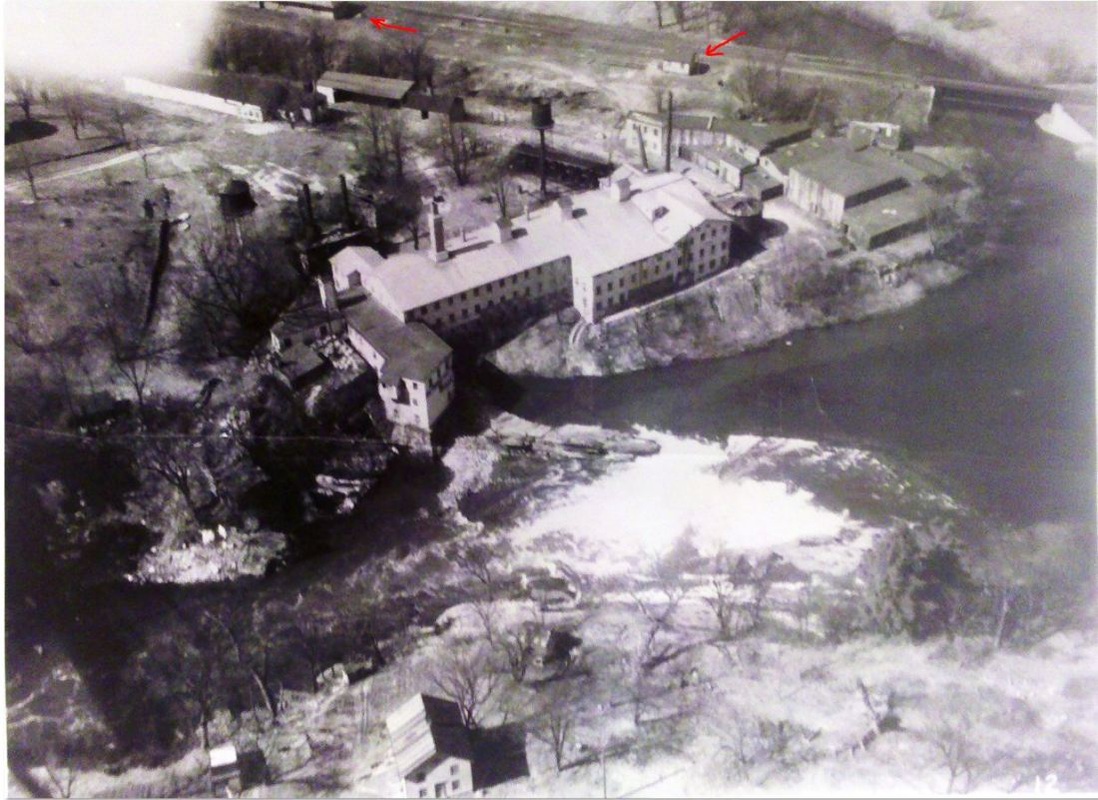
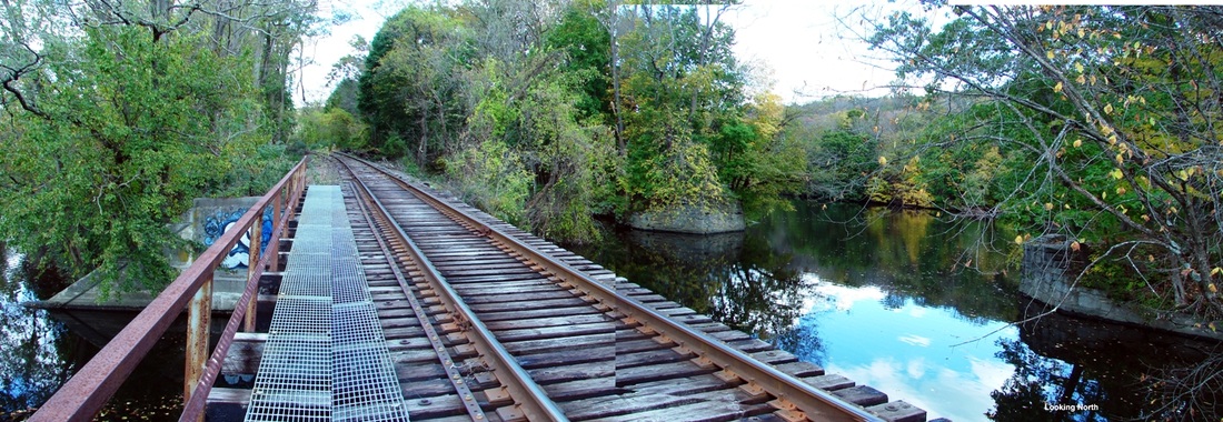
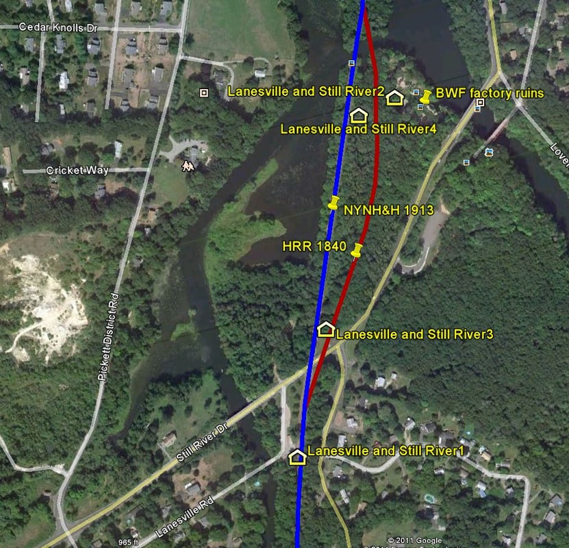
The next round of changes here was announced early in 1913 when the Courant said that "the Still River passenger and freight station in this town will be abandoned and a new passenger station put up on the western side of the tracks, about 300 feet north of the present depot, while the new freight station, on the opposite side of the tracks, will be about 1000 feet north of the present location." An article in August revised this to say that the PUC had approved the NYNH&H's petition to "substitute a new combination passenger and freight station at a new location" on the abandonment of the present stations, the figurative plural misleading since the 1905 station was a single, combination depot. The plan for dual stations was probably given up to cut costs but even greater economy was at work since the new, substitute station apparently was the 1905 depot relocated north and destined ultimately for the east side of the track. The ICC valuation photo at [1] is dated 9/18/1916 and shows the remodeled depot lengthened with double freight doors seen at the far end. The 1934 aerial photo at [2] shows the relocated station at the lower red arrow with the dormer now facing away from the track, and what may be the earlier station standing at the upper arrow. The red arrows in the sky shot at [5] point to the same positionings. The 1915 ICC valuation map at [4] shows the station on the east side of the new line and the former main dead-ended at the river and retained as a spur to serve BWF. An interesting detail to note is that, unlike the 1905 footprint, the remodeled depot shows agent's bay outcroppings on both sides of the station, likely because adding a new one facing the track was easier than spinning the station around. Amazingly, no news articles, even in the by-then-eight-page New Milford Gazette, have yet been found that bear witness to events that surely must have drawn crowds of onlookers. How, for example, was the station moved? One suggestion is that the rails were greased and the structure was pulled by horse, iron or otherwise. Compounding the confusion, the Danbury News said that the station being abandoned was the one "made from a freight car or two," showing no knowledge at all of the 1905 depot. According to the Gazette, the 'new' station was first used on 2/13/1914 but, with some folks ever dissatisfied, it said that "people are wondering why it was moved so much nearer to New Milford, making it about as easy to walk to New Milford as to take the train." Slight exaggeration perhaps, but certainly in keeping with the almost comical sequence of events and relocations here! What is only one more miscue among so many is that the val map has 'BP' instead of 'FP' on the footprint, indicating erroneously that it was a brick passenger station when the val photo shows it was a framed, wooden structure. The image on the envelope at [3], unfortunately, does not show a train running behind the BWF complex but it does give some idea of the extent of what had become a world-renowned manufacturer of paints and finishes by the early 1900s. BWF later morphed into Lithowhite Silex Co. and, as the mineral became harder to find on the property and profitability waned, the land and valuable Housatonic River water rights were sold to CL&P in 1927. Notes in the copious collection of railroad materials at the New Milford Historical Society say that the Still River stop "disappeared forever on 9/26/1926." In a slight contradiction to that, we find it still in the Official List of 1928 but not on public timetables thereafter. The photo at [6] was taken on a 10/22/2011 field trip. The view looks north along the 1913 alignment, later converted to single track and in use by today's HRR, and it shows the Still River bridge abutments for the old main just to the right. The image at [7] is a snapshot from our Track 11 Google Earth map and shows all four station locations and the quarter-mile distance within which they stood. Many thanks to NMHS for their assistance and to New Milford Public Library for their several courtesies and the use of the NMG microfilm, by far the most complete copy in the state. [REFS: HC/03/14/1913/03; HC/08/08/1913/05; DN/02/11/1914/11; NMG/02/20/1914/05][rev022318, 031223]
The next round of changes here was announced early in 1913 when the Courant said that "the Still River passenger and freight station in this town will be abandoned and a new passenger station put up on the western side of the tracks, about 300 feet north of the present depot, while the new freight station, on the opposite side of the tracks, will be about 1000 feet north of the present location." An article in August revised this to say that the PUC had approved the NYNH&H's petition to "substitute a new combination passenger and freight station at a new location" on the abandonment of the present stations, the figurative plural misleading since the 1905 station was a single, combination depot. The plan for dual stations was probably given up to cut costs but even greater economy was at work since the new, substitute station apparently was the 1905 depot relocated north and destined ultimately for the east side of the track. The ICC valuation photo at [1] is dated 9/18/1916 and shows the remodeled depot lengthened with double freight doors seen at the far end. The 1934 aerial photo at [2] shows the relocated station at the lower red arrow with the dormer now facing away from the track, and what may be the earlier station standing at the upper arrow. The red arrows in the sky shot at [5] point to the same positionings. The 1915 ICC valuation map at [4] shows the station on the east side of the new line and the former main dead-ended at the river and retained as a spur to serve BWF. An interesting detail to note is that, unlike the 1905 footprint, the remodeled depot shows agent's bay outcroppings on both sides of the station, likely because adding a new one facing the track was easier than spinning the station around. Amazingly, no news articles, even in the by-then-eight-page New Milford Gazette, have yet been found that bear witness to events that surely must have drawn crowds of onlookers. How, for example, was the station moved? One suggestion is that the rails were greased and the structure was pulled by horse, iron or otherwise. Compounding the confusion, the Danbury News said that the station being abandoned was the one "made from a freight car or two," showing no knowledge at all of the 1905 depot. According to the Gazette, the 'new' station was first used on 2/13/1914 but, with some folks ever dissatisfied, it said that "people are wondering why it was moved so much nearer to New Milford, making it about as easy to walk to New Milford as to take the train." Slight exaggeration perhaps, but certainly in keeping with the almost comical sequence of events and relocations here! What is only one more miscue among so many is that the val map has 'BP' instead of 'FP' on the footprint, indicating erroneously that it was a brick passenger station when the val photo shows it was a framed, wooden structure. The image on the envelope at [3], unfortunately, does not show a train running behind the BWF complex but it does give some idea of the extent of what had become a world-renowned manufacturer of paints and finishes by the early 1900s. BWF later morphed into Lithowhite Silex Co. and, as the mineral became harder to find on the property and profitability waned, the land and valuable Housatonic River water rights were sold to CL&P in 1927. Notes in the copious collection of railroad materials at the New Milford Historical Society say that the Still River stop "disappeared forever on 9/26/1926." In a slight contradiction to that, we find it still in the Official List of 1928 but not on public timetables thereafter. The photo at [6] was taken on a 10/22/2011 field trip. The view looks north along the 1913 alignment, later converted to single track and in use by today's HRR, and it shows the Still River bridge abutments for the old main just to the right. The image at [7] is a snapshot from our Track 11 Google Earth map and shows all four station locations and the quarter-mile distance within which they stood. Many thanks to NMHS for their assistance and to New Milford Public Library for their several courtesies and the use of the NMG microfilm, by far the most complete copy in the state. [REFS: HC/03/14/1913/03; HC/08/08/1913/05; DN/02/11/1914/11; NMG/02/20/1914/05][rev022318, 031223]
LAUREL [> BENVENUE]
LAWRENCE [> COLEBROOK]
LEAVENWORTH MILLS [> STEPNEY1]
LAWRENCE [> COLEBROOK]
LEAVENWORTH MILLS [> STEPNEY1]
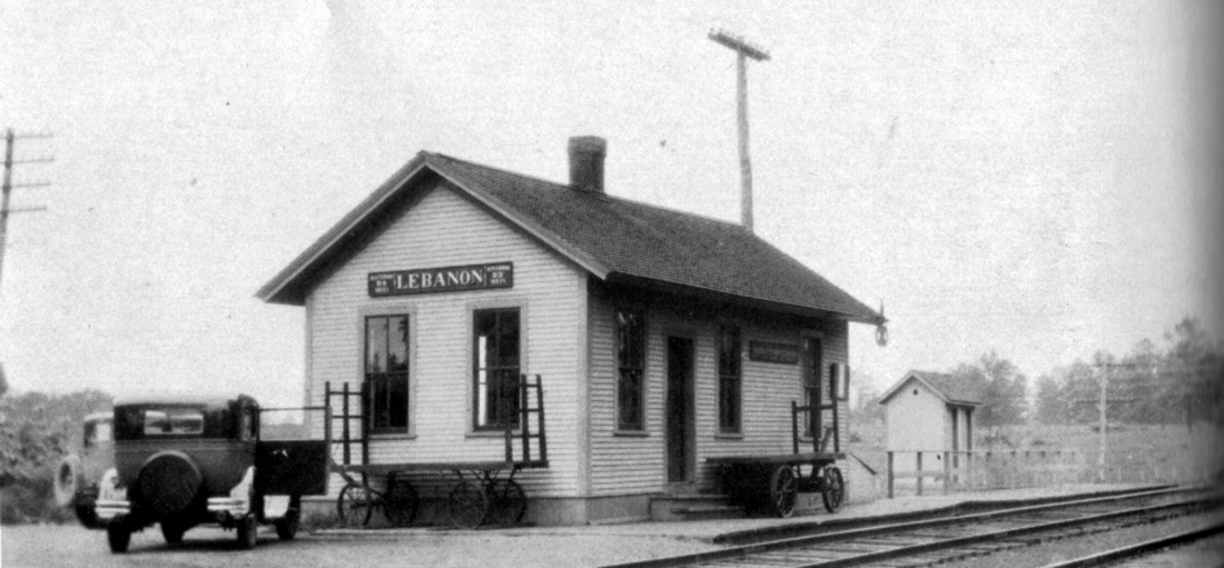
LEBANON1 [NLN, 1849]
[REFS: W37: small, like NORWICHTOWN?, $300, auth 9/3/1850]
[REFS: W37: small, like NORWICHTOWN?, $300, auth 9/3/1850]
LEBANON2 [CVT, 1877]
[REFS: CRC24.1877.18]
[REFS: CRC24.1877.18]
National Archives
|
|
|
 Guilford Free Library
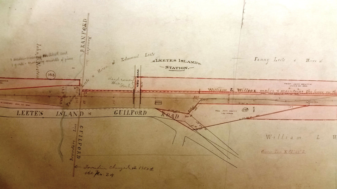
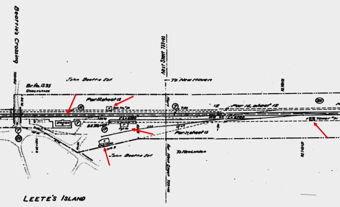
LEETES ISLAND1 [NYNH&H, c1874]
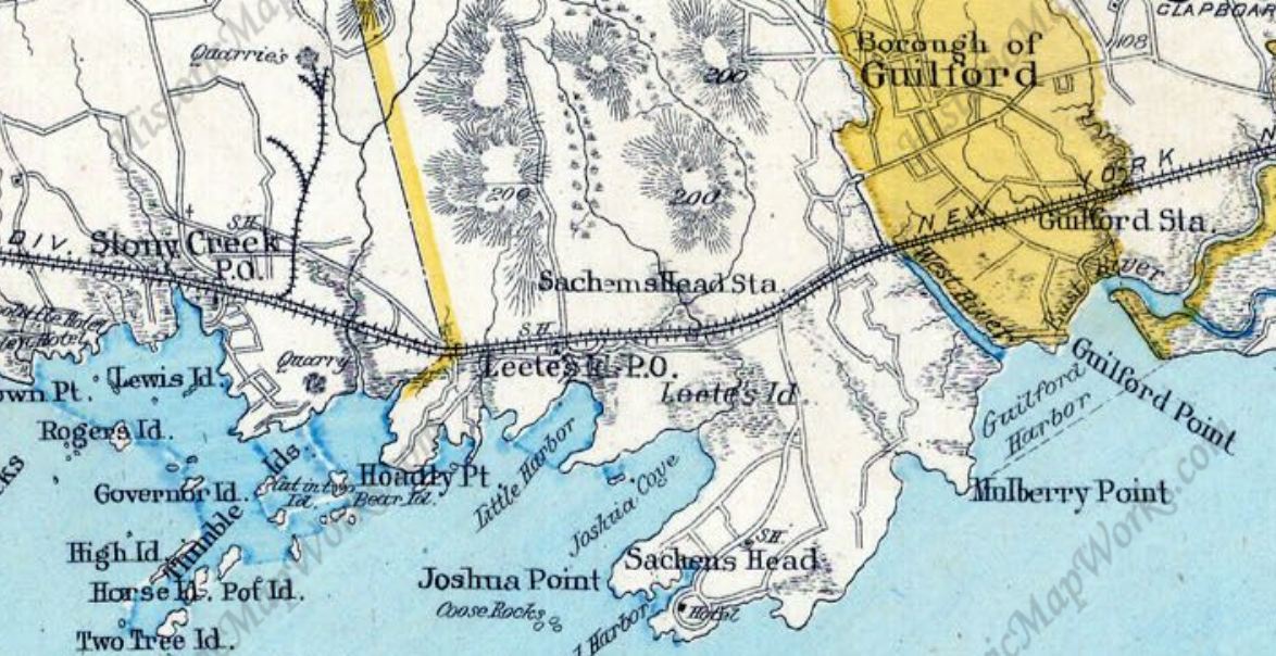
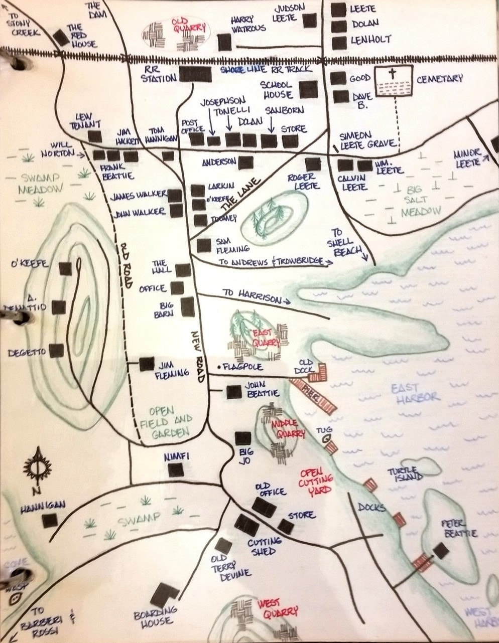
The precise date of origin of this stop in the town of GUILFORD is unclear but it seems to have been connected with John Beattie's quarry operation that began ca. 1870. Samuel Leete's ad for sale of property in 1874 mentions that it is "within ten minutes walk of the Railroad Station..." and by 1879 a station agent is mentioned in the newspapers. Double-tracking was completed from New London to here by June, 1891 and work as far as Fair Haven, in progress thereafter, was completed on 6/10/1893. The image at [1] is a 9/1/1916 valuation shot showing LEETES ISLAND1 as the freight house, a small gabled structure that was later described as "very inadequate" for the combination service it provided at this stop previously. The snippet at [2] is from the 1892 ROW atlas that shows the footprint of LEETES ISLAND1 in its original location. With the coming of the next station, it appears to have been moved, the Branford Semi-Weekly Review saying that "the old passenger depot at Leetes Island has been transformed into a freight depot and stands just east of the passenger station," meaning the new LEETES ISLAND2. The image at [3] is from the 1893 Hurd atlas and shows all the stations in this area at that time. The map at [4] shows the 'old quarry' run by John Beattie, always said to be adjacent to this station, just north of it. No wonder this stop was established here! The action shows common sense, forward thinking on the part of the NYNH&H in serving a commercial enterprise as well as providing more convenient passenger service for the surrounding community. [REFS: NHER/01/29/1874/04; CR/02/28/1874/04; 1873TT: no; 1877TT: yes; NHER/04/01/1880/01; NYH/07/30/1882 /07; NHAR 20.1891.4; BSWR/12/24/1898/02][rev112916, 122718, 010219]
The precise date of origin of this stop in the town of GUILFORD is unclear but it seems to have been connected with John Beattie's quarry operation that began ca. 1870. Samuel Leete's ad for sale of property in 1874 mentions that it is "within ten minutes walk of the Railroad Station..." and by 1879 a station agent is mentioned in the newspapers. Double-tracking was completed from New London to here by June, 1891 and work as far as Fair Haven, in progress thereafter, was completed on 6/10/1893. The image at [1] is a 9/1/1916 valuation shot showing LEETES ISLAND1 as the freight house, a small gabled structure that was later described as "very inadequate" for the combination service it provided at this stop previously. The snippet at [2] is from the 1892 ROW atlas that shows the footprint of LEETES ISLAND1 in its original location. With the coming of the next station, it appears to have been moved, the Branford Semi-Weekly Review saying that "the old passenger depot at Leetes Island has been transformed into a freight depot and stands just east of the passenger station," meaning the new LEETES ISLAND2. The image at [3] is from the 1893 Hurd atlas and shows all the stations in this area at that time. The map at [4] shows the 'old quarry' run by John Beattie, always said to be adjacent to this station, just north of it. No wonder this stop was established here! The action shows common sense, forward thinking on the part of the NYNH&H in serving a commercial enterprise as well as providing more convenient passenger service for the surrounding community. [REFS: NHER/01/29/1874/04; CR/02/28/1874/04; 1873TT: no; 1877TT: yes; NHER/04/01/1880/01; NYH/07/30/1882 /07; NHAR 20.1891.4; BSWR/12/24/1898/02][rev112916, 122718, 010219]
|
|
|
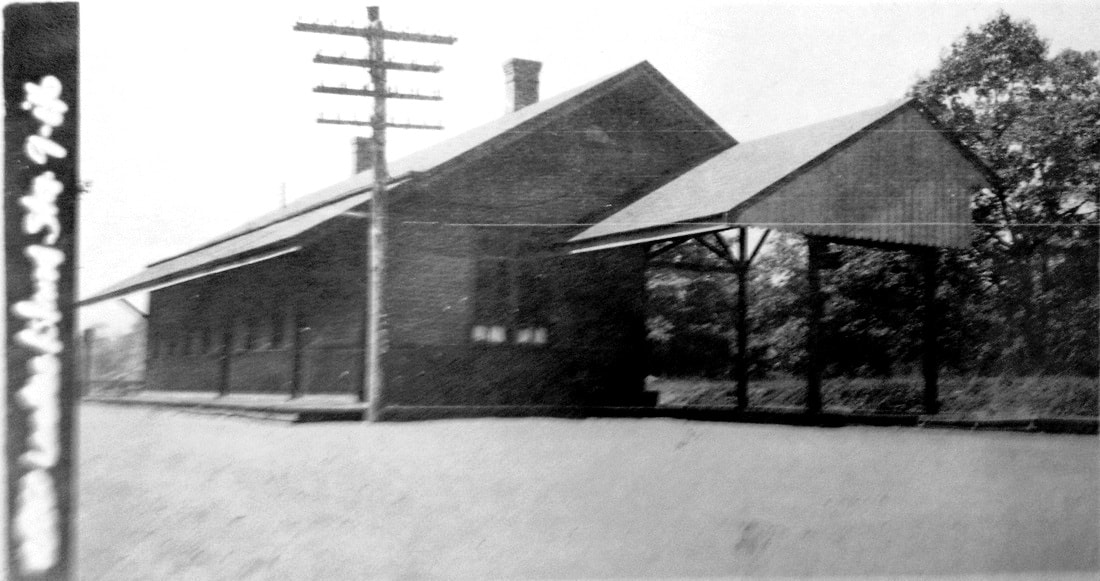
LEETES ISLAND2 [NYNH&H, 1898]
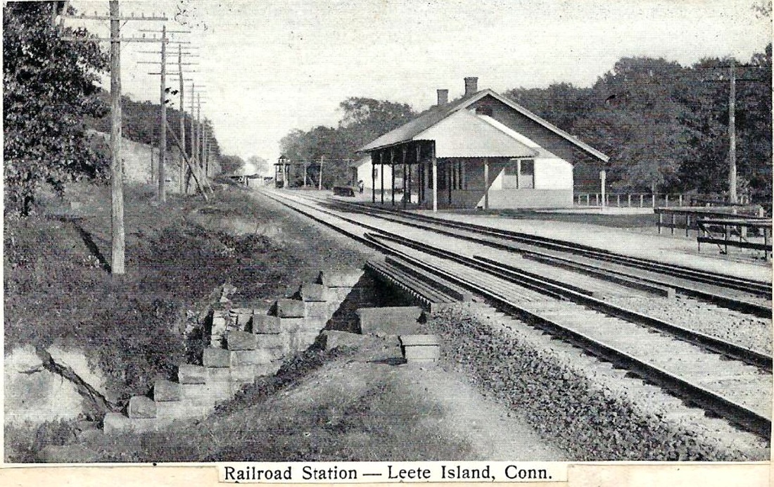
This saltbox-style structure was noted in the railroad commissioners report for 1898. The Shore Line Times said the foundation was completed in August, 1898 and was ready for the superstructure. Late in October, the paper said that "the new depot at Leete's Island is about completed and almost ready for occupancy. It is a great improvement to this portion of the line and will be a vast improvement over the former very inadequate accommodations. The design is much the same as Stony Creek, being very commodious considering the amount of traffic at this station. It has a long covered platform, which greatly adds to the appearance and utility. It stands to the east of the old station and the grounds about it have been filled up and leveled off so that there is now a fine broad drive close to the platform and entrance to the building. When, ah when will Guilford be treated thusly?" With the knowledge that the old station was made into the freight house as reported in the BSWR on 12/24/1898, we can speculate that the new station opened in November. In March, 1899 the SLT said "Yes indeed. We are proud of our new station and the agent keeps it looking just as it ought to look." The large size, seemingly comparable to MADISON2 at ~1800 sq ft, is curious at this relatively minor stop, which also had a freight house, a section house and SS-91 built in 1892 to control access to the small yard here. All of this was doubtless connected with the quarrying operation, which employed hundreds of potential passengers and shipped tons of the area's well-known pink granite for a number of important building projects in the Northeast including the base of the Statue of Liberty in 1884. All the structures are in view in the 1910-postmarked card at [1] and the red arrows on the 1915 val map at [2] show the depot at left and signal station at right. The val photo at [3] is dated 9/1/1916. It is not known exactly when this station came down but a local publication reportedly quotes resident Richmond H. Curtiss as saying it was not there in 1937. Service curtailments and the downsizing or disposal of stations following the bankruptcy proceedings of 1935 may have played a role here; sanction for the April, 1936 discontinuance of the stop at WESTBROOK is reflected in a letter from the NYNH&H to the PUC on 12/13/1936. [REFS: CRC46.1898.19; SLT/08/19/1898/04; SLT/10/28/1898/04; SLT/03/24/1899/04; Taking Time to Remember (1998)][rev112916, 123118]
This saltbox-style structure was noted in the railroad commissioners report for 1898. The Shore Line Times said the foundation was completed in August, 1898 and was ready for the superstructure. Late in October, the paper said that "the new depot at Leete's Island is about completed and almost ready for occupancy. It is a great improvement to this portion of the line and will be a vast improvement over the former very inadequate accommodations. The design is much the same as Stony Creek, being very commodious considering the amount of traffic at this station. It has a long covered platform, which greatly adds to the appearance and utility. It stands to the east of the old station and the grounds about it have been filled up and leveled off so that there is now a fine broad drive close to the platform and entrance to the building. When, ah when will Guilford be treated thusly?" With the knowledge that the old station was made into the freight house as reported in the BSWR on 12/24/1898, we can speculate that the new station opened in November. In March, 1899 the SLT said "Yes indeed. We are proud of our new station and the agent keeps it looking just as it ought to look." The large size, seemingly comparable to MADISON2 at ~1800 sq ft, is curious at this relatively minor stop, which also had a freight house, a section house and SS-91 built in 1892 to control access to the small yard here. All of this was doubtless connected with the quarrying operation, which employed hundreds of potential passengers and shipped tons of the area's well-known pink granite for a number of important building projects in the Northeast including the base of the Statue of Liberty in 1884. All the structures are in view in the 1910-postmarked card at [1] and the red arrows on the 1915 val map at [2] show the depot at left and signal station at right. The val photo at [3] is dated 9/1/1916. It is not known exactly when this station came down but a local publication reportedly quotes resident Richmond H. Curtiss as saying it was not there in 1937. Service curtailments and the downsizing or disposal of stations following the bankruptcy proceedings of 1935 may have played a role here; sanction for the April, 1936 discontinuance of the stop at WESTBROOK is reflected in a letter from the NYNH&H to the PUC on 12/13/1936. [REFS: CRC46.1898.19; SLT/08/19/1898/04; SLT/10/28/1898/04; SLT/03/24/1899/04; Taking Time to Remember (1998)][rev112916, 123118]

|
|
|
LEETES ISLAND3 [NYNH&H, 1936?]
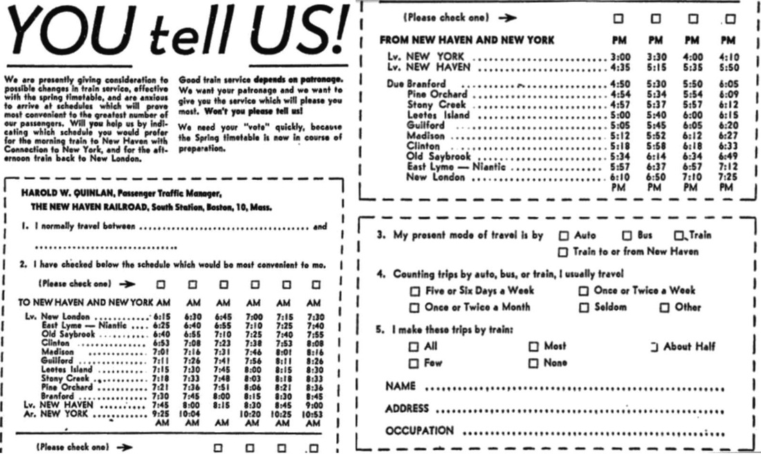
The photo at [1] was supplied to us by a member of the Leete family for which this locale is named. The origin date of this modest shelter is unclear but probably coincided with the removal of LEETES ISLAND2 in the years prior to 1937. A 1939 article in The Branford Review about the pending demolition of BRANFORD3 said that the railroad intended to replace that station with a small, wooden structure like the one here. The article at [2] shows that the post-war NYNH&H was actively soliciting passenger input on Shore Line scheduling in 1949 and timetables show service here endured until the beginning of Amtrak on 5/1/1971. Penn Central's Clamdigger maintained service from New London to New Haven until January 28, 1972 and the shelter was removed shortly thereafter. A TCS contributor from the Beattie family who worked for the NYNH&H informs us additionally that, in contrast to its predecessors, this structure stood on the north side of the track. Beatties Crossing, he continues, was eliminated in 1893 by undergrade bridge 13.93 for which John Beattie himself supplied the abutments by contract with the railroad dated 12/11/1893. The street below is today's New Quarry Rd. but the NYNH&H continued to use the old crossing name to the end. LEETES ISLAND serves as an interesting example of a station created by industrial activity and that gentrified into a commuter stop the later days of its hundred-year existence. [REFS: 2/8/1932TT, 9/29/1935TT, 4/25/1937TT, 6/25/1939TT: all yes; BR/08/17/1939/01; NLD/03/29/1949/05; PCTT 2/2/1969: yes; HC/01/29/1972/01][rev112916]
The photo at [1] was supplied to us by a member of the Leete family for which this locale is named. The origin date of this modest shelter is unclear but probably coincided with the removal of LEETES ISLAND2 in the years prior to 1937. A 1939 article in The Branford Review about the pending demolition of BRANFORD3 said that the railroad intended to replace that station with a small, wooden structure like the one here. The article at [2] shows that the post-war NYNH&H was actively soliciting passenger input on Shore Line scheduling in 1949 and timetables show service here endured until the beginning of Amtrak on 5/1/1971. Penn Central's Clamdigger maintained service from New London to New Haven until January 28, 1972 and the shelter was removed shortly thereafter. A TCS contributor from the Beattie family who worked for the NYNH&H informs us additionally that, in contrast to its predecessors, this structure stood on the north side of the track. Beatties Crossing, he continues, was eliminated in 1893 by undergrade bridge 13.93 for which John Beattie himself supplied the abutments by contract with the railroad dated 12/11/1893. The street below is today's New Quarry Rd. but the NYNH&H continued to use the old crossing name to the end. LEETES ISLAND serves as an interesting example of a station created by industrial activity and that gentrified into a commuter stop the later days of its hundred-year existence. [REFS: 2/8/1932TT, 9/29/1935TT, 4/25/1937TT, 6/25/1939TT: all yes; BR/08/17/1939/01; NLD/03/29/1949/05; PCTT 2/2/1969: yes; HC/01/29/1972/01][rev112916]

|

|
LEONARDS BRIDGE [NHM&W, 1873]
Stop established in the town of Lebanon by the NHM&W in 1873. [REFS: NHER/06/04/1888/01]
Stop established in the town of Lebanon by the NHM&W in 1873. [REFS: NHER/06/04/1888/01]
LEWIS GROVE [> GROVE BEACH]
LIBERTY HILL [> CHESTNUT HILL]
LILY LAKE [> SOUTH KENT]
LIBERTY HILL [> CHESTNUT HILL]
LILY LAKE [> SOUTH KENT]
Dave Peters Collection
|
|
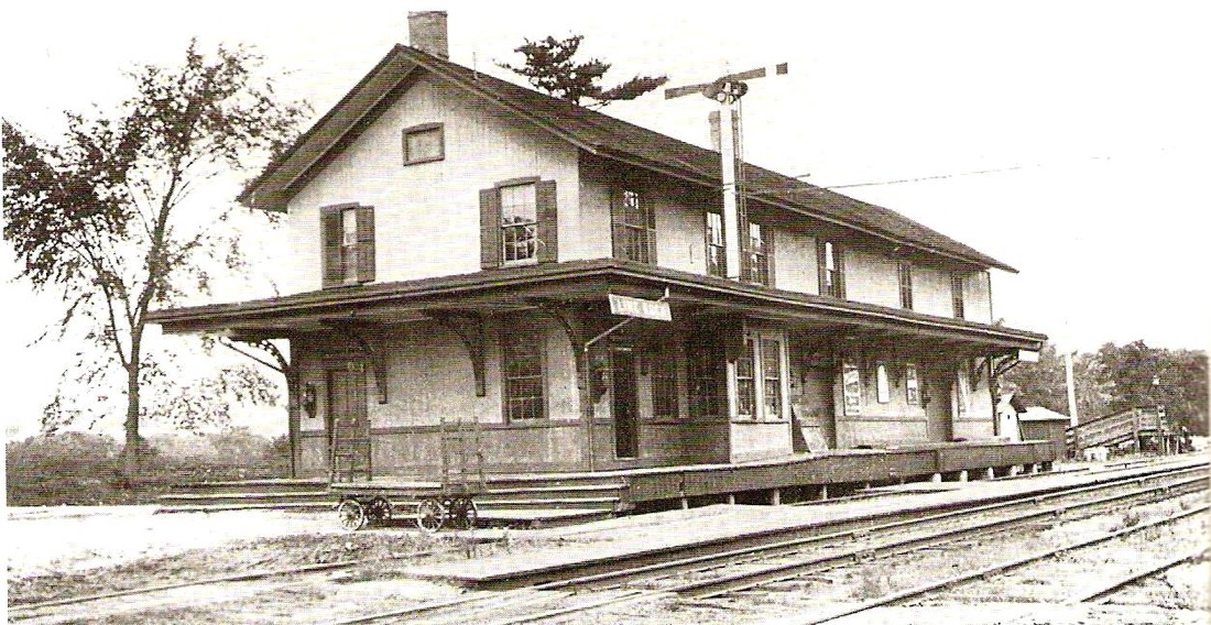
LIME ROCK1 [HRR, 1871]
An examination of timetables shows that this was not an original stop in the town of Canaan on the HRR. The "new Lime Rock Depot" was reported by the Pittsfield Sun to be "nearly completed" early in 1871 and said to be intended to take pressure off the FALLS VILLAGE depot in the handling of the "large business" of the Barnum Richardson Co. The company's co-founder, William H. Barnum, would become HRR president on 2/23/1872 and hold the office for many years, last serving in 1888 and exiting when New York interests got control of the railroad. This depot burned in 1914. [REFS: PS/02/02/1871/01; CWN/07/28/1871/02; PS/02/29/1872/02; CWN/04/30/1903/04: Borden's creamery; D80; R54]
An examination of timetables shows that this was not an original stop in the town of Canaan on the HRR. The "new Lime Rock Depot" was reported by the Pittsfield Sun to be "nearly completed" early in 1871 and said to be intended to take pressure off the FALLS VILLAGE depot in the handling of the "large business" of the Barnum Richardson Co. The company's co-founder, William H. Barnum, would become HRR president on 2/23/1872 and hold the office for many years, last serving in 1888 and exiting when New York interests got control of the railroad. This depot burned in 1914. [REFS: PS/02/02/1871/01; CWN/07/28/1871/02; PS/02/29/1872/02; CWN/04/30/1903/04: Borden's creamery; D80; R54]
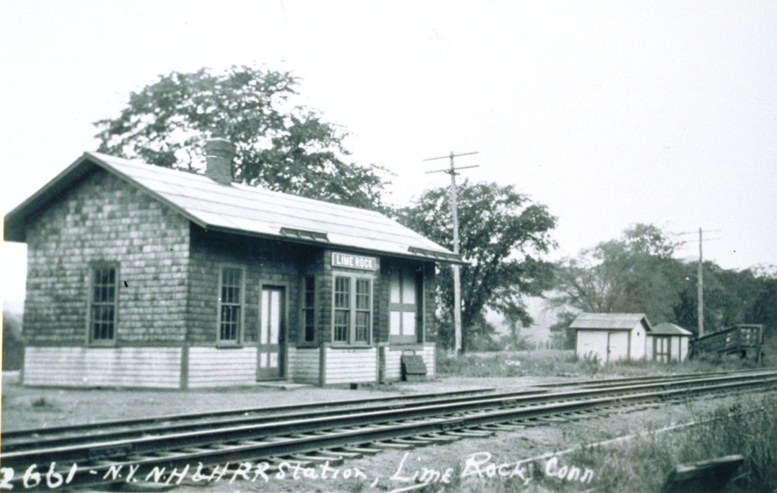
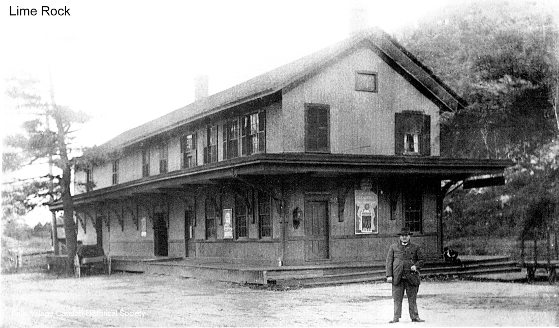
LIME ROCK2 [NYNH&H, 1915]
MERWINSVILLE2 was moved here in 1915. Lewis H. Benton took this photo, his #2661, in 1930, likely on on June 22. [rev030717]
MERWINSVILLE2 was moved here in 1915. Lewis H. Benton took this photo, his #2661, in 1930, likely on on June 22. [rev030717]
LISBON [> JEWETT CITY/H]

LITCHFIELD/N1 [NRR, 1849]
The original station was built when this stop was established by the NRR in 1849 and we assume that it looked like ANSONIA1 and NAUGATUCK1. Though the 1854LC map has this area labeled properly as East Litchfield, the stop on the NRR was called LITCHFIELD. According to an article in the Courant, a new depot was built here in 1875. The railroad commisioners say nothing about this nor do any other newspapers, so what happened to LITCHFIELD1 - fire is the usual culprit - is not yet known. Hopefully an NRR annual report is lurking somewhere to clear this up. [REFS: HDC/08/06/1875/03]
The original station was built when this stop was established by the NRR in 1849 and we assume that it looked like ANSONIA1 and NAUGATUCK1. Though the 1854LC map has this area labeled properly as East Litchfield, the stop on the NRR was called LITCHFIELD. According to an article in the Courant, a new depot was built here in 1875. The railroad commisioners say nothing about this nor do any other newspapers, so what happened to LITCHFIELD1 - fire is the usual culprit - is not yet known. Hopefully an NRR annual report is lurking somewhere to clear this up. [REFS: HDC/08/06/1875/03]
|

|
|
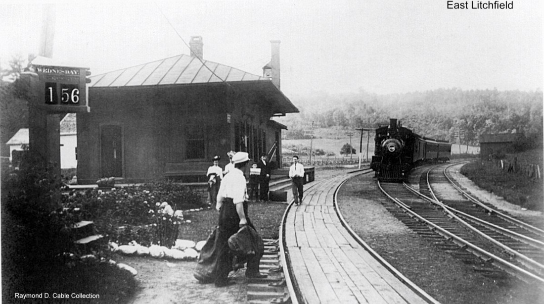
LITCHFIELD/N2 [NRR, 1875]
This station was built in 1875. It would become EAST LITCHFIELD some time between our 1890 and 1894TTs, shortly after the NYNH&H leased the NRR in 1887. One would think the renaming would have only happened in 1898 when the NYNH&H got control of the Shepaug RR and added another LITCHFIELD to its list of stations but the name was always appropriate for the depot that served the eastern part of this town. The 1916 val photo at [1] reflects the changes made in 1911 that included track realignment, grade crossing elimination and diversion of the Naugatuck River flowing just to the east. The language of the day called even a slight relocation an 'abandonment' but, as we have seen elsewhere, it was the precise location that was abandoned, not the stop or even the station building. It looks to us like it was moved to a new foundation that gave it a higher profile, with concrete curbing and a new roof the finishing touches. The north freight wing may also have been added at this time. This stop, along with several others on the old NRR from Waterbury to Winsted, lost passenger service in 1926. A Torrington Register newspaper article says that freight service ended here on 12/1/1923 and a 1936 article indicates that the station's "demolition was accomplished almost a year ago" in 1935. Many thanks to local resident Eileen Schmidt for her untiring efforts to research the history of this station. Her photo album can be retrieved by clicking here. [REFS: HC/02/02/1911/05; HC/02/09/1911/07; HC/02/25/1911/14; HC/03/25/1911/06; TR/11/09/1923/00; HC/06/20/1926/A12][rev042117]
This station was built in 1875. It would become EAST LITCHFIELD some time between our 1890 and 1894TTs, shortly after the NYNH&H leased the NRR in 1887. One would think the renaming would have only happened in 1898 when the NYNH&H got control of the Shepaug RR and added another LITCHFIELD to its list of stations but the name was always appropriate for the depot that served the eastern part of this town. The 1916 val photo at [1] reflects the changes made in 1911 that included track realignment, grade crossing elimination and diversion of the Naugatuck River flowing just to the east. The language of the day called even a slight relocation an 'abandonment' but, as we have seen elsewhere, it was the precise location that was abandoned, not the stop or even the station building. It looks to us like it was moved to a new foundation that gave it a higher profile, with concrete curbing and a new roof the finishing touches. The north freight wing may also have been added at this time. This stop, along with several others on the old NRR from Waterbury to Winsted, lost passenger service in 1926. A Torrington Register newspaper article says that freight service ended here on 12/1/1923 and a 1936 article indicates that the station's "demolition was accomplished almost a year ago" in 1935. Many thanks to local resident Eileen Schmidt for her untiring efforts to research the history of this station. Her photo album can be retrieved by clicking here. [REFS: HC/02/02/1911/05; HC/02/09/1911/07; HC/02/25/1911/14; HC/03/25/1911/06; TR/11/09/1923/00; HC/06/20/1926/A12][rev042117]
|
|
|

|
|
|
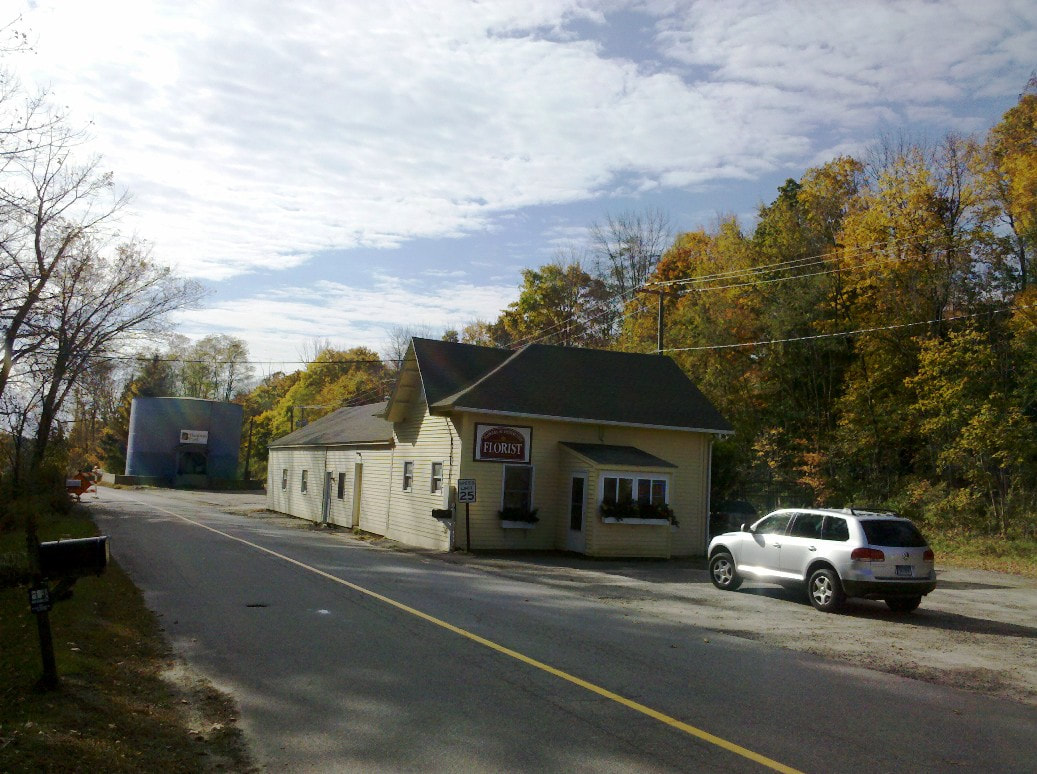
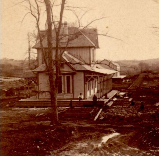
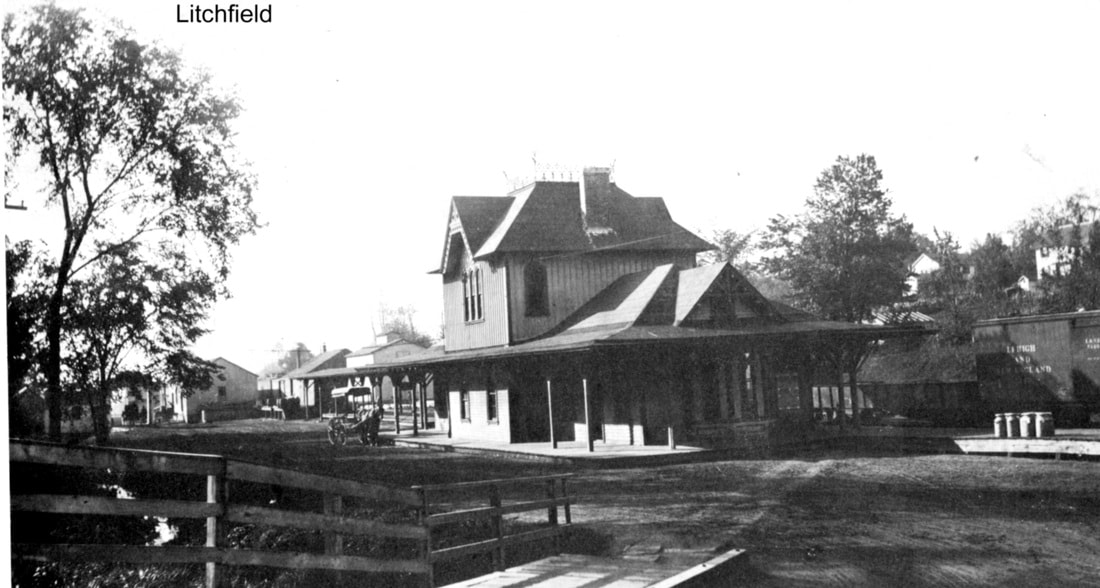
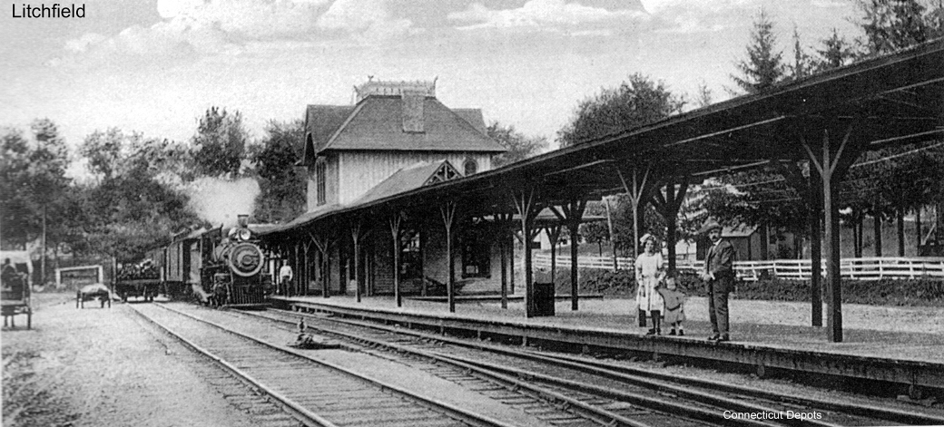
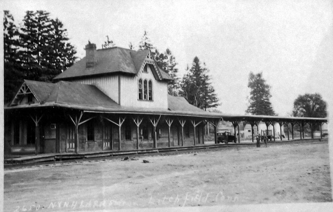
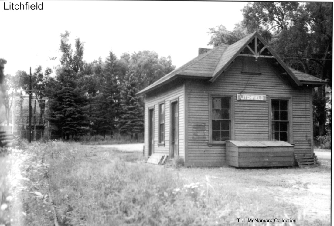
LITCHFIELD/S [SRR, 1871]
Train travel in the hinterlands didn't get much more enjoyable than on the Shepaug Valley RR. Last stop was this station in Litchfield, the shire town for the county with its magnificent views of the surrounding area. The Courant reported in July, 1871 that the 25x75-ft Victorian structure was being built and in August that it was nearly completed. The upper floor of the two-story would be used for company offices. Rails for the line on the north end, the article continued, were being carted from the NRR station [see LITCHFIELD/N1, above]. When finished it said that the Shepaug would make the county seat "more easily accessible and do away with the necessity of a six mile stage route to the hill...," meaning up from the Naugatuck River, the eastern border of the town. Today Conn. Rte. 118 still makes that steep trek. And so this interior line from HAWLEYVILLE would serve for nearly 80 years under different corporate names, the last 50 from 1898 to 1948 as the New Haven's Litchfield Branch. The great stereo-card view at [1] has to be from early 1871 with the depot unfinished. Workmen are seated on the step and track, not yet laid all the way up to the station, is seen at right. The photo at [2] shows the depot ca. 1890 without coversheds, and at [3] ca. 1900 with the canopies installed. The 1922 map at [4] shows the arrangement of the railroad facilties at that time. The shot at [5] is Lewis H. Benton's #2650 taken in 1930, likely on 6/22. Fellow photographer Irving Drake is at middle and his automobile, the duo's transport vehicle, is behind him. Passenger service ended in 1930. The second story and the wings were removed probably in 1941. ICC authorization for abandonment of the branch had come on 5/3/1948 and the rails were lifted later that year. The remaining portion is seen at [5] with track gone. Sometime afterward the structure was rotated 90 degrees, as seen at [6]. The photo at [7] is one we took some years ago and shows the building in use by a florist, the addition on the south end perhaps serving as a greenhouse. The center part of the 1871 station at 28 Russell St. is still in commercial use in 2022. [REFS: HDC/07/31/1871/04; HDC/08/01/1871/02; WH/09/08/1871/02; DN/07/03/1872/02; HC/05/04/1948/03; C112; K60; D145; R62] [rev 042117, 060820, 051822]
Train travel in the hinterlands didn't get much more enjoyable than on the Shepaug Valley RR. Last stop was this station in Litchfield, the shire town for the county with its magnificent views of the surrounding area. The Courant reported in July, 1871 that the 25x75-ft Victorian structure was being built and in August that it was nearly completed. The upper floor of the two-story would be used for company offices. Rails for the line on the north end, the article continued, were being carted from the NRR station [see LITCHFIELD/N1, above]. When finished it said that the Shepaug would make the county seat "more easily accessible and do away with the necessity of a six mile stage route to the hill...," meaning up from the Naugatuck River, the eastern border of the town. Today Conn. Rte. 118 still makes that steep trek. And so this interior line from HAWLEYVILLE would serve for nearly 80 years under different corporate names, the last 50 from 1898 to 1948 as the New Haven's Litchfield Branch. The great stereo-card view at [1] has to be from early 1871 with the depot unfinished. Workmen are seated on the step and track, not yet laid all the way up to the station, is seen at right. The photo at [2] shows the depot ca. 1890 without coversheds, and at [3] ca. 1900 with the canopies installed. The 1922 map at [4] shows the arrangement of the railroad facilties at that time. The shot at [5] is Lewis H. Benton's #2650 taken in 1930, likely on 6/22. Fellow photographer Irving Drake is at middle and his automobile, the duo's transport vehicle, is behind him. Passenger service ended in 1930. The second story and the wings were removed probably in 1941. ICC authorization for abandonment of the branch had come on 5/3/1948 and the rails were lifted later that year. The remaining portion is seen at [5] with track gone. Sometime afterward the structure was rotated 90 degrees, as seen at [6]. The photo at [7] is one we took some years ago and shows the building in use by a florist, the addition on the south end perhaps serving as a greenhouse. The center part of the 1871 station at 28 Russell St. is still in commercial use in 2022. [REFS: HDC/07/31/1871/04; HDC/08/01/1871/02; WH/09/08/1871/02; DN/07/03/1872/02; HC/05/04/1948/03; C112; K60; D145; R62] [rev 042117, 060820, 051822]
LOCKWOODS [> NOROTON]
|
Chronicling America, Library of Congress
|

New Haven Museum
|
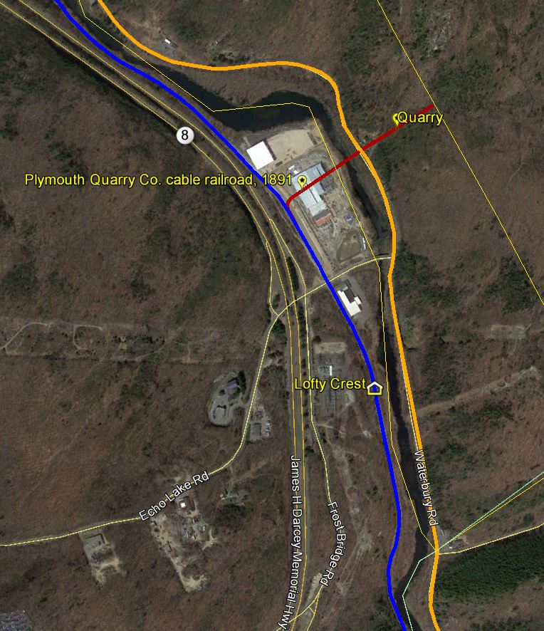
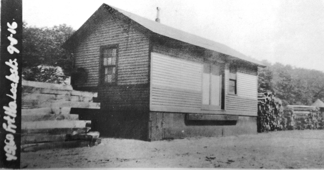
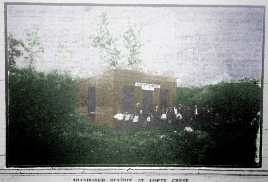
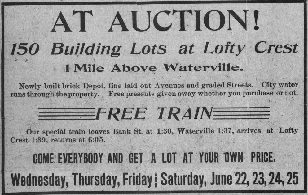
LOFTY CREST [NYNH&H, 1904]
This was a short-lived, privately built station on the NRR in Watertown, above CHASES MILLS and below JERICHO. It was established in connection with a housing development known as Lofty Crest promoted by the Capital Realty Co. Sales efforts included free rail transportation from Waterbury to the purpose-built LOFTY CREST depot, trading stamps and free gifts to everyone visiting the sale of 150 lots that began on 6/22/1904, the ad at [2] in the Waterbury Evening Democrat kicking off the promotion. Though this was touted as "a rare opportunity to secure land land at your own price," the project seems to have foundered, even with balloon ascensions and "... the services of Daredevil Lamonte to jump from parachute..." The Waterbury Republican said... "Lofty Crest is the legend on the sign above the door of a small brick building, about the size of a trolley waiting shed, that stands on the Naugatuck division about a mile above Waterville. The building was erected some years ago by Dr. C. Art Ward to be used as a railroad station when the town of Lofty Crest was established. The town was never established and no trains ever stop at the station. The small one-story brick building is the sole remnant of what once was ambitiously planned out for a new suburb of Waterbury." The Watertown News mentions the development obliquely in 1917 and later tells us that some lots seized by the town were about to be sold in 1928 for payment of back taxes. Our initial encounter with LOFTY CREST came through the photo at [1] accompanying a July, 1909 news story about the discovery of a man's decomposed body at the abandoned station. The building was described as "15 feet square, of brick with a solid stone underpinning." Since there was no opening "in the cellar," it was necessary to tear away a large portion of the flooring to get the body out. Initially thought to be a homicide, it was later presumed to be a suicide or death by natural causes. The report states further that "a crowd of the morbidly curious, including many boys of supposedly tender age, filled the building and greatly hampered the work of the Coroner and his assistants." The 1912 map at [3] locates the depot and validates the abandoned status. The location of the stop was just below Frost Bridge Rd., as seen on our Track 11 Google Earth map snippet at [4]. [REFS: WED/06/22/1904/03; HC/07/26/1909/10; WAM/07/26/1909/02; WRE/07/26/1909/01; SR/07/29/1909/12; WTN/08/01/1917/08; WTN/09/28/1928/01][rev093018]
This was a short-lived, privately built station on the NRR in Watertown, above CHASES MILLS and below JERICHO. It was established in connection with a housing development known as Lofty Crest promoted by the Capital Realty Co. Sales efforts included free rail transportation from Waterbury to the purpose-built LOFTY CREST depot, trading stamps and free gifts to everyone visiting the sale of 150 lots that began on 6/22/1904, the ad at [2] in the Waterbury Evening Democrat kicking off the promotion. Though this was touted as "a rare opportunity to secure land land at your own price," the project seems to have foundered, even with balloon ascensions and "... the services of Daredevil Lamonte to jump from parachute..." The Waterbury Republican said... "Lofty Crest is the legend on the sign above the door of a small brick building, about the size of a trolley waiting shed, that stands on the Naugatuck division about a mile above Waterville. The building was erected some years ago by Dr. C. Art Ward to be used as a railroad station when the town of Lofty Crest was established. The town was never established and no trains ever stop at the station. The small one-story brick building is the sole remnant of what once was ambitiously planned out for a new suburb of Waterbury." The Watertown News mentions the development obliquely in 1917 and later tells us that some lots seized by the town were about to be sold in 1928 for payment of back taxes. Our initial encounter with LOFTY CREST came through the photo at [1] accompanying a July, 1909 news story about the discovery of a man's decomposed body at the abandoned station. The building was described as "15 feet square, of brick with a solid stone underpinning." Since there was no opening "in the cellar," it was necessary to tear away a large portion of the flooring to get the body out. Initially thought to be a homicide, it was later presumed to be a suicide or death by natural causes. The report states further that "a crowd of the morbidly curious, including many boys of supposedly tender age, filled the building and greatly hampered the work of the Coroner and his assistants." The 1912 map at [3] locates the depot and validates the abandoned status. The location of the stop was just below Frost Bridge Rd., as seen on our Track 11 Google Earth map snippet at [4]. [REFS: WED/06/22/1904/03; HC/07/26/1909/10; WAM/07/26/1909/02; WRE/07/26/1909/01; SR/07/29/1909/12; WTN/08/01/1917/08; WTN/09/28/1928/01][rev093018]
|
Trumbull Historical Society
|
|
|
|
Trumbull Historical Society
|
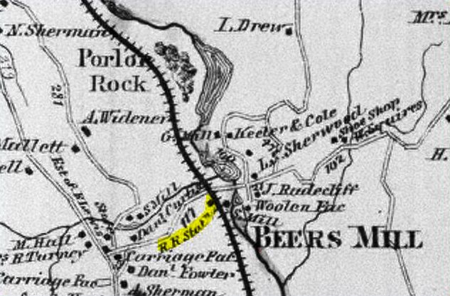
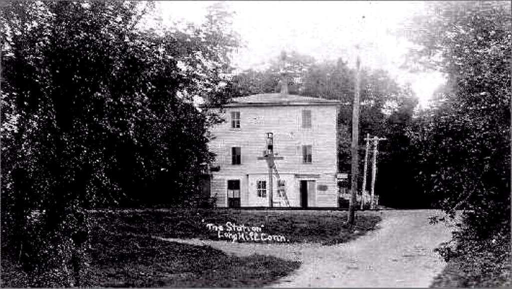
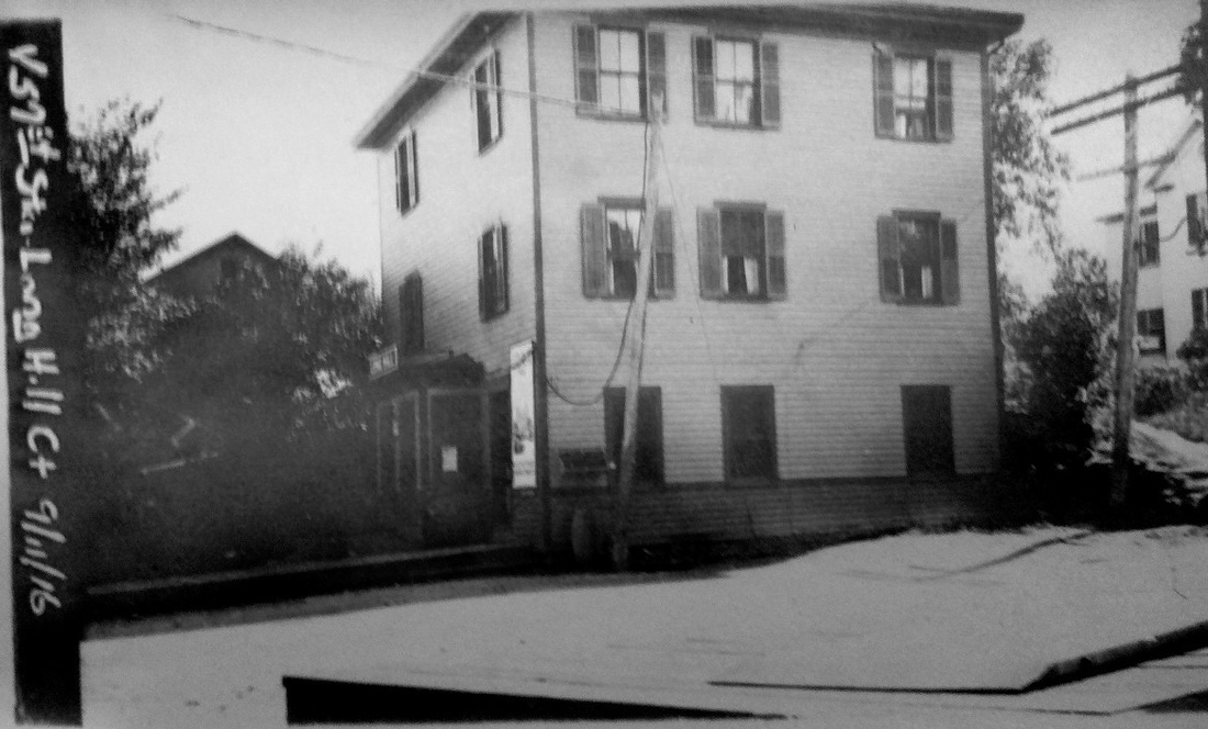
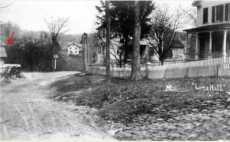
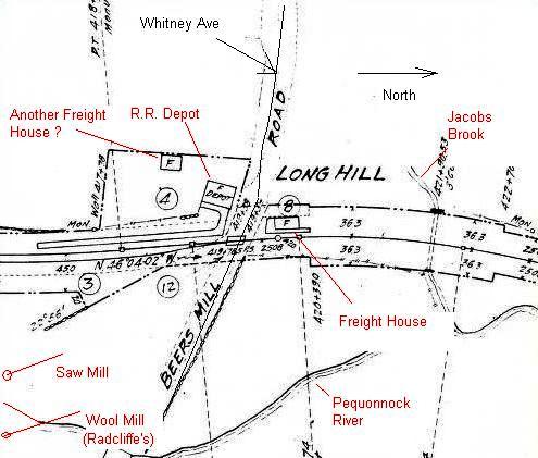
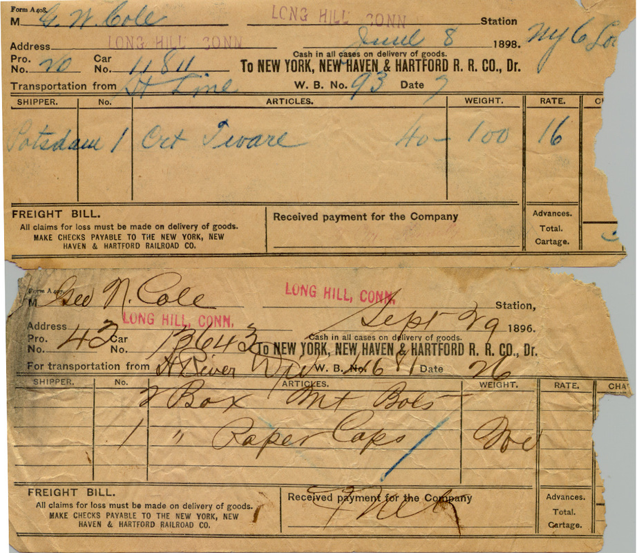
LONG HILL [HRR, 1840?]
This TRUMBULL stop was originally called BEERS MILL and possibly dates to the 1840 opening of the HRR, though it does not appear on early timetables as was sometimes the case with minor stations. The station was named for the grist mill that operated here on the Pequonnock River and both are seen on the 1874 map at [1]. The map also shows the celebrated landmark, Parlor Rock [see P stations], just to the north of the depot. An 1851 HRR Fourth of July broadside lists BEERS MILL, though it is unclear if it was a station manned by an agent, and it later appears under the name LONG HILL, a flag stop on an 1883TT. We do not know if the structure seen in the photos dated back to 1840 or if it was preceded by another depot. The shot at [2] looks westward toward the station, probably at the turn of the century. The val photo at [3] is dated 9/11/1916 and the shot at [4] shows the corner of the freight house, across Beers Mill Rd., at the red arrow. The section house, still standing in 2015 on Rte. 25 in Monroe by the old post office, became one of the first Subway sandwich shops in the area, according to Bernie Sippin, former owner of the property who remembers the move. The 1915 val map at [5], annotated by our friends at the Trumbull Historical Society [click here], shows the arrangement of the station grounds at the time. The freight bills at [6] date from after the NYNH&H 1892 takeover of the HRR. Beers Mill Rd. is Whitney Ave. today and the old station platform site is a major access point for the HRR right of way that is now a popular recreational trail. Click here for more. THS has verified that, after passenger service ended in 1932, this station was dismantled and reassembled as a residence on nearby Moose Hill Rd. in Monroe, where it still stands today. Many thanks to Kevin Daly and Bill Bracco for their interest and enthusiasm in 'tracking' this down. We wonder if there was any newspaper coverage and would appreciate hearing if anyone has an article on this locally historic event. According to Monroe land records, it was 1937 for the move, but the 1938 SSRR list still has it as railroad property retired and to be removed, albeit with the tenements rented. We are told by THS that credit for preserving information about the move goes to the late Michael "Mickey" Sciortino, a first-generation Italian-American and well-known Long Hill resident, who avidly researched Trumbull history until he passed away in 2006 at the enviable age of 99. Mickey donated his material and photo collection to THS where his memory is treasured today. [REFS: HDC/09/11/1874/01; HDC/07/21/1875/04; HDC/08/26/1875/04; HDC/12/05/1876/02][rev010318]
This TRUMBULL stop was originally called BEERS MILL and possibly dates to the 1840 opening of the HRR, though it does not appear on early timetables as was sometimes the case with minor stations. The station was named for the grist mill that operated here on the Pequonnock River and both are seen on the 1874 map at [1]. The map also shows the celebrated landmark, Parlor Rock [see P stations], just to the north of the depot. An 1851 HRR Fourth of July broadside lists BEERS MILL, though it is unclear if it was a station manned by an agent, and it later appears under the name LONG HILL, a flag stop on an 1883TT. We do not know if the structure seen in the photos dated back to 1840 or if it was preceded by another depot. The shot at [2] looks westward toward the station, probably at the turn of the century. The val photo at [3] is dated 9/11/1916 and the shot at [4] shows the corner of the freight house, across Beers Mill Rd., at the red arrow. The section house, still standing in 2015 on Rte. 25 in Monroe by the old post office, became one of the first Subway sandwich shops in the area, according to Bernie Sippin, former owner of the property who remembers the move. The 1915 val map at [5], annotated by our friends at the Trumbull Historical Society [click here], shows the arrangement of the station grounds at the time. The freight bills at [6] date from after the NYNH&H 1892 takeover of the HRR. Beers Mill Rd. is Whitney Ave. today and the old station platform site is a major access point for the HRR right of way that is now a popular recreational trail. Click here for more. THS has verified that, after passenger service ended in 1932, this station was dismantled and reassembled as a residence on nearby Moose Hill Rd. in Monroe, where it still stands today. Many thanks to Kevin Daly and Bill Bracco for their interest and enthusiasm in 'tracking' this down. We wonder if there was any newspaper coverage and would appreciate hearing if anyone has an article on this locally historic event. According to Monroe land records, it was 1937 for the move, but the 1938 SSRR list still has it as railroad property retired and to be removed, albeit with the tenements rented. We are told by THS that credit for preserving information about the move goes to the late Michael "Mickey" Sciortino, a first-generation Italian-American and well-known Long Hill resident, who avidly researched Trumbull history until he passed away in 2006 at the enviable age of 99. Mickey donated his material and photo collection to THS where his memory is treasured today. [REFS: HDC/09/11/1874/01; HDC/07/21/1875/04; HDC/08/26/1875/04; HDC/12/05/1876/02][rev010318]
LORDS FARM [> CHESTER1]

LOVETTS [HP&F, 1854]
This station was in the town of Lisbon, the site now in Sprague after that town was incorporated in 1861. There is no station shown on the 1854NL map, coincidentally the year when the HP&F opened this line, but it is on the 1868 map at left. On our HP&F ETT #102 (9/18/1872) it is listed as being 2.75 miles east of BALTIC. VERSAILLES, one mile to the east of the LOVETTS location, likely replaced it ca. 1872. An 1876 timetable no longer lists LOVETTS but does list VERSAILLES. [REFS: CRC15.1868.30][rev09212021]
This station was in the town of Lisbon, the site now in Sprague after that town was incorporated in 1861. There is no station shown on the 1854NL map, coincidentally the year when the HP&F opened this line, but it is on the 1868 map at left. On our HP&F ETT #102 (9/18/1872) it is listed as being 2.75 miles east of BALTIC. VERSAILLES, one mile to the east of the LOVETTS location, likely replaced it ca. 1872. An 1876 timetable no longer lists LOVETTS but does list VERSAILLES. [REFS: CRC15.1868.30][rev09212021]

|
|
|
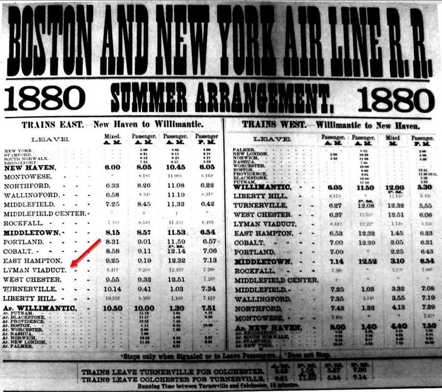
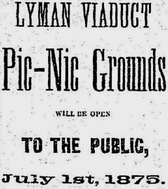
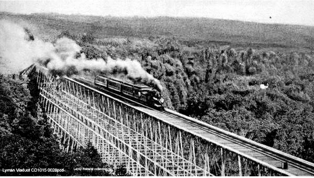
LYMAN VIADUCT1 [NHM&W, 1873]
This station was in the town of COLCHESTER. The image at [1] is plate 62 from the March, 1886 ROW atlas at the New Haven Museum. Our red arrow points from the pencil notation "Moved to sta. no. 635" to surveyors station 607 where LYMAN VIADUCT1 was located. This was on the west side of the towering iron structure named For David Lyman, pioneering promoter of the NHM&W. It was completed in June, 1872 by the Phoenix Bridge Co. of Pennsylvania. The earliest possible mention of a depot here comes in 1886 when we read that "John Cashman, aged 25, a trackman living at Easthampton, was struck by the Air Line Limited [then the 1884 New England Limited] express at Lyman Viaduct station Monday night and instantly killed. He leaves a wife and child." The first timetable listing we have found thus far is 5/8/1876 with the NHM&W already reorganized as the B&NYAL, but newspaper evidence shows excursions to this stop came even before regular train service began on 8/12/1873. The full text of the 1875 ad seen at [2] goes on to say that "all trains stop on the grounds" which were available "without cost" and "conducted strictly on the temperance principle," attracting the prohibition crowd until ca. 1900. "Ample shelter," swings, a grove, refreshments, "rustic accommodations" for fifty gentlemen wishing overnight stays were spoken of and the Masonic outing from New Haven on 8/19/1874 brought Felsburg's Band for pavilion dancing and a "monster clam chowder." The view at [3] captures a train thought to be westbound on the viaduct, built for two tracks but hosting only a single one on the south side of the structure from the opening of the line. A summer 1880 timetable is seen at [4] with LYMAN VIADUCT as a flag stop for all trains. It apparently was not until 1899 that the railroad decided to put a "permanent agent in charge... and make it a telegraph station," this largely to better serve the Brown Bros. paper manufacturer at Comstock Bridge. Often said to be in EAST HAMPTON, the 1100-ft long, 135-ft high viaduct is entirely in Colchester. The directness of this 'air line' route, 16 miles shorter than the Shore Line and 21 shorter than via Springfield and the B&A, was not lost on the NYNH&H when it later got control of both the B&NYAL and the NY&NE. Plans for straightening, reducing grades, and double-tracking would resurface in 1896 and persist until 1915. Ultimately, the project was abandoned and New York-Boston traffic was left primarily to the Shore Line. [REFS: CR/08/13/1870/02; MC/09/21/1870/02; MC/06/05/1872/02; MDC/09/09/1872/02; MDC/05/22/1873/02; HDC/08/13/ 1873/04; CR/08/30/1873/03; MDC/11/10 /1873/02; MC/04/29/1874/02; MDC/06/16/1874/02; MC/07/08/1874/02; MDC/07/13/1874/02; HDC/08/13/1874/04; NHER/08/23/1880/04; HDC/04/07/1886/01; SR/02/28/1896/06; NYT/12/14/1896/03; NHER/08/30/1898/01; HC/02/24/1900/03; HC/10/20/1904/05; SR/10/20/1904/03; HC/04/10/1905/01; BH/11/14/1905/12][rev070315]
This station was in the town of COLCHESTER. The image at [1] is plate 62 from the March, 1886 ROW atlas at the New Haven Museum. Our red arrow points from the pencil notation "Moved to sta. no. 635" to surveyors station 607 where LYMAN VIADUCT1 was located. This was on the west side of the towering iron structure named For David Lyman, pioneering promoter of the NHM&W. It was completed in June, 1872 by the Phoenix Bridge Co. of Pennsylvania. The earliest possible mention of a depot here comes in 1886 when we read that "John Cashman, aged 25, a trackman living at Easthampton, was struck by the Air Line Limited [then the 1884 New England Limited] express at Lyman Viaduct station Monday night and instantly killed. He leaves a wife and child." The first timetable listing we have found thus far is 5/8/1876 with the NHM&W already reorganized as the B&NYAL, but newspaper evidence shows excursions to this stop came even before regular train service began on 8/12/1873. The full text of the 1875 ad seen at [2] goes on to say that "all trains stop on the grounds" which were available "without cost" and "conducted strictly on the temperance principle," attracting the prohibition crowd until ca. 1900. "Ample shelter," swings, a grove, refreshments, "rustic accommodations" for fifty gentlemen wishing overnight stays were spoken of and the Masonic outing from New Haven on 8/19/1874 brought Felsburg's Band for pavilion dancing and a "monster clam chowder." The view at [3] captures a train thought to be westbound on the viaduct, built for two tracks but hosting only a single one on the south side of the structure from the opening of the line. A summer 1880 timetable is seen at [4] with LYMAN VIADUCT as a flag stop for all trains. It apparently was not until 1899 that the railroad decided to put a "permanent agent in charge... and make it a telegraph station," this largely to better serve the Brown Bros. paper manufacturer at Comstock Bridge. Often said to be in EAST HAMPTON, the 1100-ft long, 135-ft high viaduct is entirely in Colchester. The directness of this 'air line' route, 16 miles shorter than the Shore Line and 21 shorter than via Springfield and the B&A, was not lost on the NYNH&H when it later got control of both the B&NYAL and the NY&NE. Plans for straightening, reducing grades, and double-tracking would resurface in 1896 and persist until 1915. Ultimately, the project was abandoned and New York-Boston traffic was left primarily to the Shore Line. [REFS: CR/08/13/1870/02; MC/09/21/1870/02; MC/06/05/1872/02; MDC/09/09/1872/02; MDC/05/22/1873/02; HDC/08/13/ 1873/04; CR/08/30/1873/03; MDC/11/10 /1873/02; MC/04/29/1874/02; MDC/06/16/1874/02; MC/07/08/1874/02; MDC/07/13/1874/02; HDC/08/13/1874/04; NHER/08/23/1880/04; HDC/04/07/1886/01; SR/02/28/1896/06; NYT/12/14/1896/03; NHER/08/30/1898/01; HC/02/24/1900/03; HC/10/20/1904/05; SR/10/20/1904/03; HC/04/10/1905/01; BH/11/14/1905/12][rev070315]
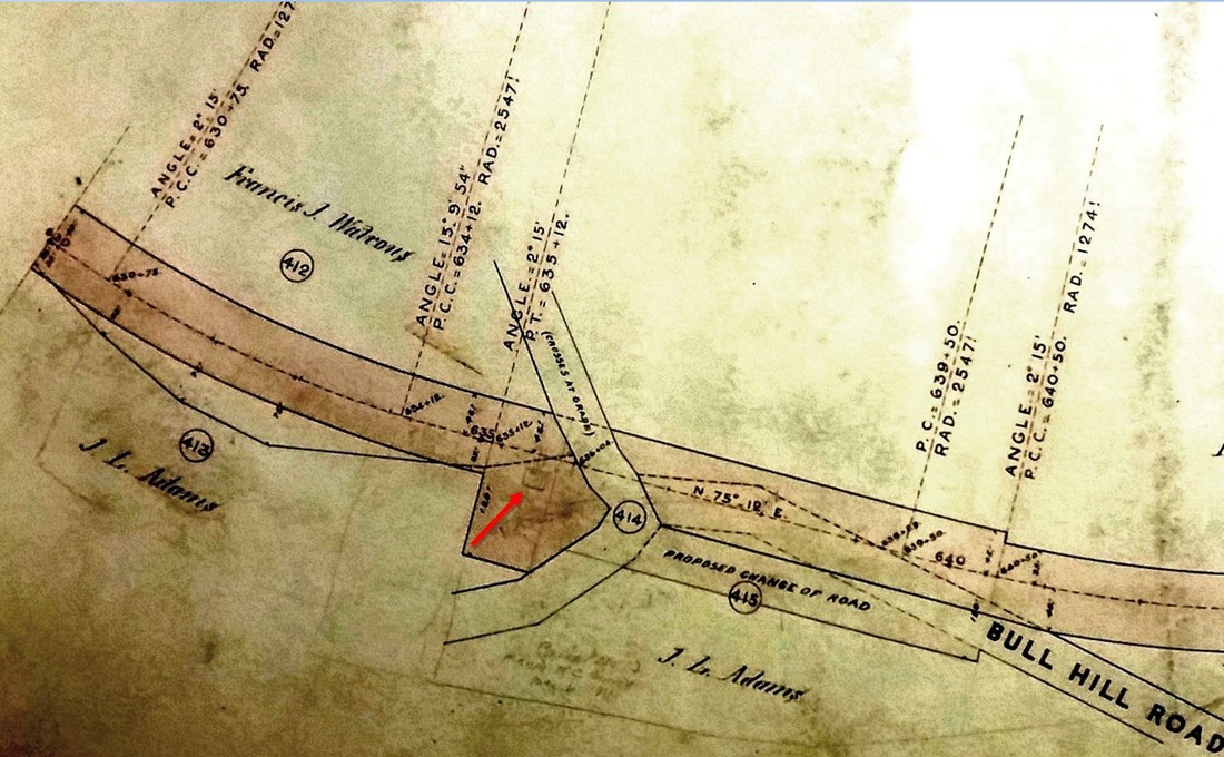
|
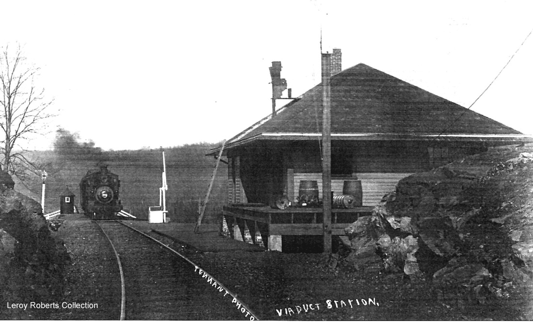
|
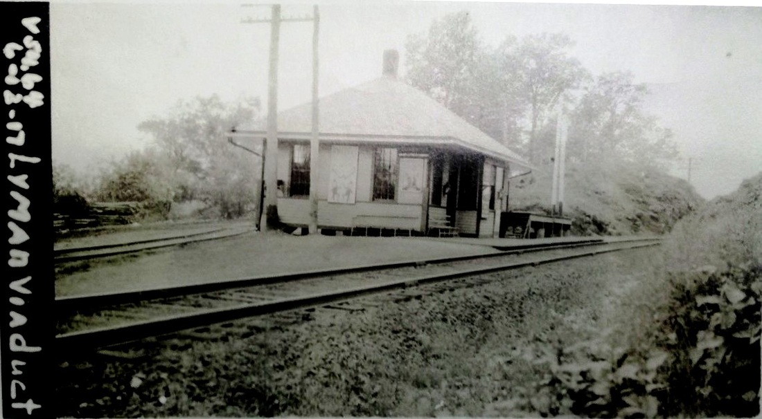
|

|
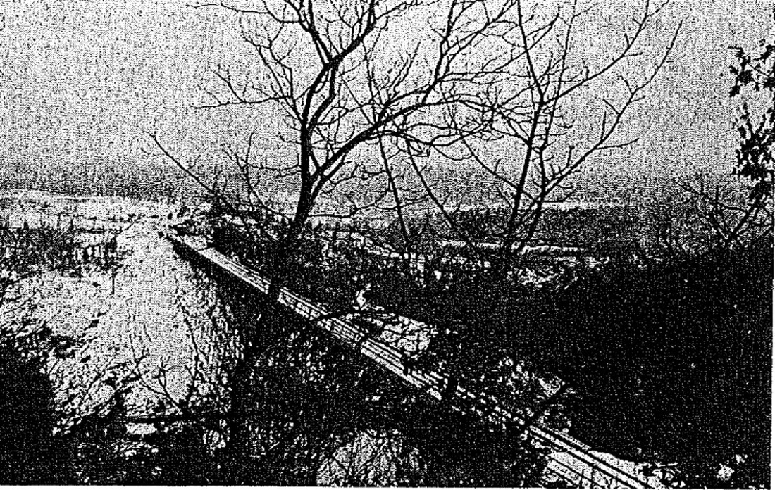
|

|
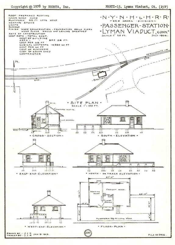
Copyright NHRHTA
LYMAN VIADUCT2 [NYNH&H, 1906]
The 1886 atlas image at [1] shows the LYMAN VIADUCT2 location; our red arrow points to surveyor station 635 at the Bull Hill Rd. grade crossing. The photo at [2] probably dates to between 1906 and 1917. It looks east with a westbound train approaching the station, not, as sometimes labeled, coming off the Lyman Viaduct which is about a half mile ahead of the locomotive. Note the ladder and the roof rungs up to the order board atop the depot, the apparatus moved to a mast by the time the 6/12/1917 val photo at [3] was taken. The 9/27/1923 PUC shot [4] looks west at the cattle fences and the house track going behind the station. Worries about the safety of this and the nearby Rapallo Viaduct in East Hampton dated back to 1905 when night watchmen were hired for hourly patrols across each structure. Faced with patching and painting or replacing the old structures or filling them in, the NYNH&H chose the latter. The val map (not shown) and, more curiously, the pre-fill image at [5], show a second track on the viaduct. Exactly when this was done and how much Air Line double-tracking was completed is unclear. The upgrades from 1911 to 1914 to allow heavier trains included the massive fill project seen in progress at [6] with a double culvert below for Dickinson Creek at the base of the embankment, work said in the June, 1913 annual report to be 60% complete. The station plans at [7] show the second track with a design date of July, 1906 and a tracing date of 1/9/1913. The well-known crises and the death of J.P. Morgan in the latter year prompted the hasty exit of Pres. Mellen and the grand plan for more Boston service on this route lingered but died shortly thereafter. A 12/2/1923TT shows LYMAN VIADUCT, mostly as a flag stop, still being served by three weekday trains and one one on Sundays. Rail passenger service reportedly ended in 1927 and our 11/15/1928TT shows NETCo doing the honors thereafter. As late as 1930, a forest-fire article implies the station was still standing but, by our 10/15/1944 station-number list, it is no longer seen even as a freight stop. The fate of the building is unknown. Track from PORTLAND to WILLIMANTIC came out in 1965 and a parking area at the Bull Hill Rd. station site now serves those wishing to enjoy the Air Line Rail Trail. [REFS: HC/11/20/1899/10; HDC/05/22/1905/14; NHAR35.1906.6; HC/03/18/1910/16; BH/04/11/1910/02; HC/11/09/1910/11; HC12/15/1910/16; CRC59.1911.15+; NHAR42.1913.21; SU/02/07/1914/03; HC/04/30/1930/01; HC/11/07/1965/10A][rev070315]
The 1886 atlas image at [1] shows the LYMAN VIADUCT2 location; our red arrow points to surveyor station 635 at the Bull Hill Rd. grade crossing. The photo at [2] probably dates to between 1906 and 1917. It looks east with a westbound train approaching the station, not, as sometimes labeled, coming off the Lyman Viaduct which is about a half mile ahead of the locomotive. Note the ladder and the roof rungs up to the order board atop the depot, the apparatus moved to a mast by the time the 6/12/1917 val photo at [3] was taken. The 9/27/1923 PUC shot [4] looks west at the cattle fences and the house track going behind the station. Worries about the safety of this and the nearby Rapallo Viaduct in East Hampton dated back to 1905 when night watchmen were hired for hourly patrols across each structure. Faced with patching and painting or replacing the old structures or filling them in, the NYNH&H chose the latter. The val map (not shown) and, more curiously, the pre-fill image at [5], show a second track on the viaduct. Exactly when this was done and how much Air Line double-tracking was completed is unclear. The upgrades from 1911 to 1914 to allow heavier trains included the massive fill project seen in progress at [6] with a double culvert below for Dickinson Creek at the base of the embankment, work said in the June, 1913 annual report to be 60% complete. The station plans at [7] show the second track with a design date of July, 1906 and a tracing date of 1/9/1913. The well-known crises and the death of J.P. Morgan in the latter year prompted the hasty exit of Pres. Mellen and the grand plan for more Boston service on this route lingered but died shortly thereafter. A 12/2/1923TT shows LYMAN VIADUCT, mostly as a flag stop, still being served by three weekday trains and one one on Sundays. Rail passenger service reportedly ended in 1927 and our 11/15/1928TT shows NETCo doing the honors thereafter. As late as 1930, a forest-fire article implies the station was still standing but, by our 10/15/1944 station-number list, it is no longer seen even as a freight stop. The fate of the building is unknown. Track from PORTLAND to WILLIMANTIC came out in 1965 and a parking area at the Bull Hill Rd. station site now serves those wishing to enjoy the Air Line Rail Trail. [REFS: HC/11/20/1899/10; HDC/05/22/1905/14; NHAR35.1906.6; HC/03/18/1910/16; BH/04/11/1910/02; HC/11/09/1910/11; HC12/15/1910/16; CRC59.1911.15+; NHAR42.1913.21; SU/02/07/1914/03; HC/04/30/1930/01; HC/11/07/1965/10A][rev070315]
|
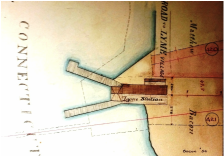
New Haven Museum
|
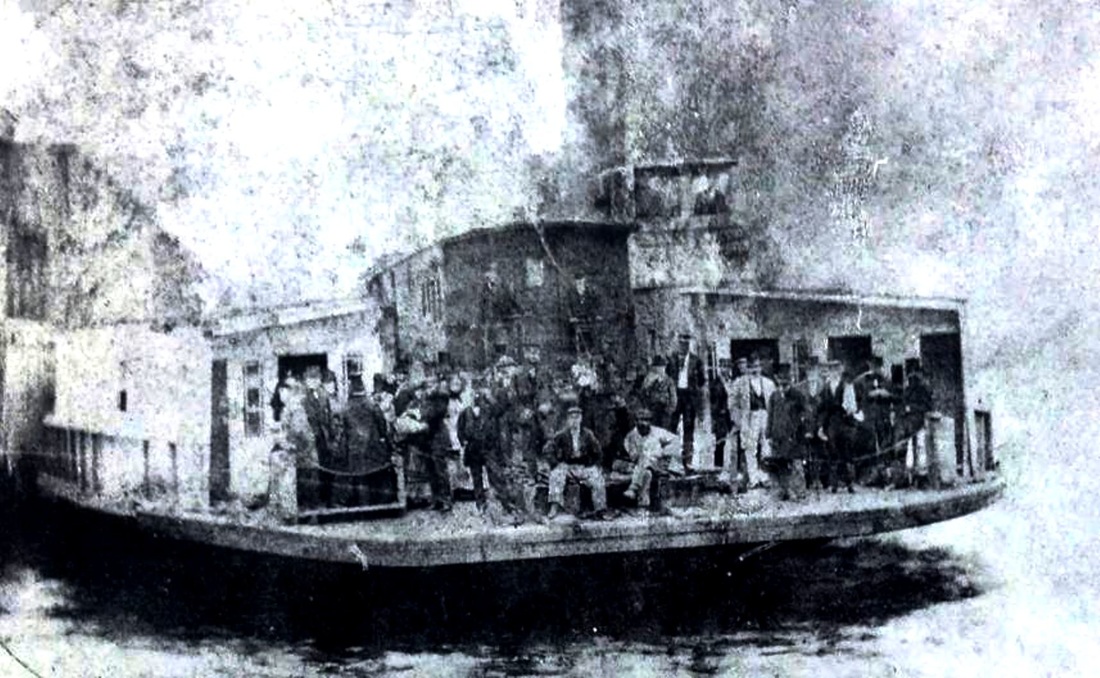
|
LYME1 [NH&NL, 1852]
This stop was established in the town of Old Lyme in 1852 when the NH&NL opened, its location is seen on the 1854NL map at [1]. The footprint is shown in the 1871 real estate atlas at [2]. A newspaper article in 1872 said important changes were being made to the right of way between this and the CONNECTICUT RIVER depot on the opposite western shore. In some ways this may have been the culmination of the work in building the bridge that opened on 6/4/1870 and enabled the discontinuance of the ferry Shaumpishus [3] that had run since the railroad opened. The other major river crossing, the Thames, from New London to Groton would not be bridged until 1889, each feat making the Shore Line a more competitive route to Boston. We have no photo yet of LYME1. [REFS: MC/10/23/1872/02][rev072115]
This stop was established in the town of Old Lyme in 1852 when the NH&NL opened, its location is seen on the 1854NL map at [1]. The footprint is shown in the 1871 real estate atlas at [2]. A newspaper article in 1872 said important changes were being made to the right of way between this and the CONNECTICUT RIVER depot on the opposite western shore. In some ways this may have been the culmination of the work in building the bridge that opened on 6/4/1870 and enabled the discontinuance of the ferry Shaumpishus [3] that had run since the railroad opened. The other major river crossing, the Thames, from New London to Groton would not be bridged until 1889, each feat making the Shore Line a more competitive route to Boston. We have no photo yet of LYME1. [REFS: MC/10/23/1872/02][rev072115]
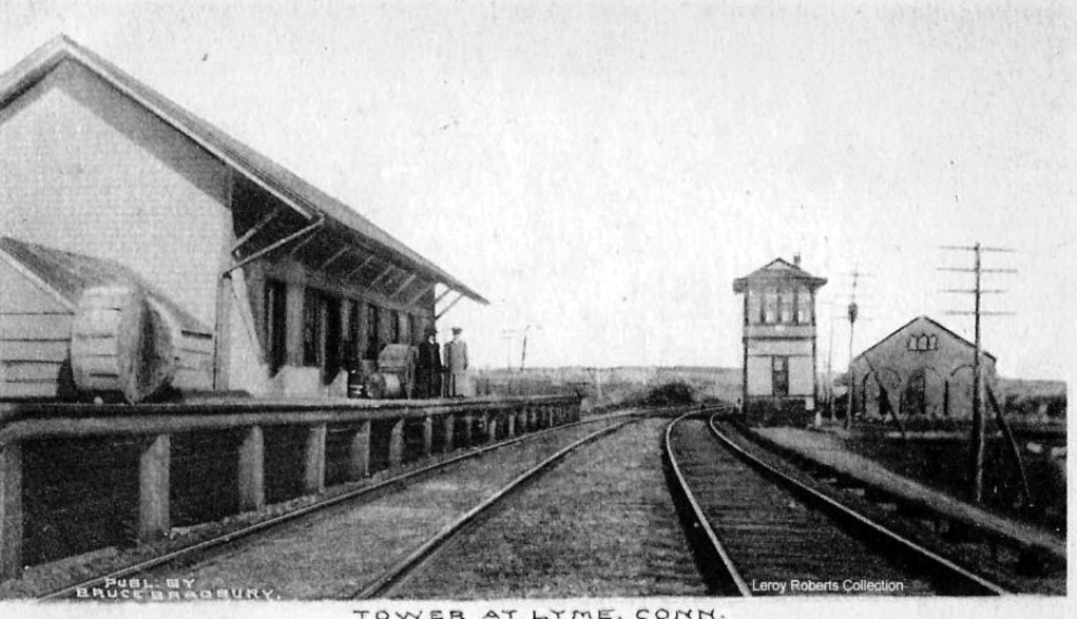
|
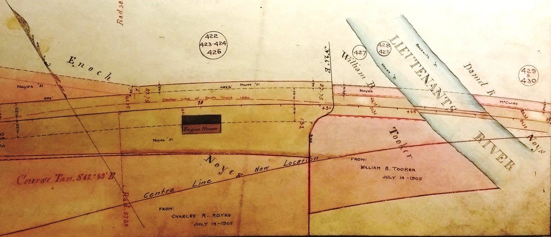
New Haven Museum
|
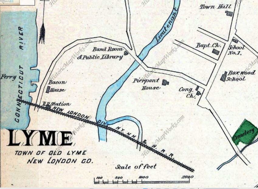
LYME2 [NYNH&H, 1875]
With the 1893 tower in the distance, this is a photo of LYME2. The Courant said early in 1875 that the plans had been drawn up and the contract awarded "for the erection of a large depot at Lyme proper" and that, as soon as it was free of frost, ground would be broken for the foundation. The railroad commissioners mention in their 1876 annual report that a new depot needed here had been completed and "it was all that could be required." We also note the three-stall engine house adjacent to the tower. It is shown on the 1871 real estate map at [2]. The 1893 Hurd map at [3] shows the station on the 1870 relocation of the ROW for the bridge, a little farther from the river and below the ferry dock. [REFS: HDC/03/30/1875/04; NYH/04/12/1893/10; CRC23.1876.21][rev072115]
With the 1893 tower in the distance, this is a photo of LYME2. The Courant said early in 1875 that the plans had been drawn up and the contract awarded "for the erection of a large depot at Lyme proper" and that, as soon as it was free of frost, ground would be broken for the foundation. The railroad commissioners mention in their 1876 annual report that a new depot needed here had been completed and "it was all that could be required." We also note the three-stall engine house adjacent to the tower. It is shown on the 1871 real estate map at [2]. The 1893 Hurd map at [3] shows the station on the 1870 relocation of the ROW for the bridge, a little farther from the river and below the ferry dock. [REFS: HDC/03/30/1875/04; NYH/04/12/1893/10; CRC23.1876.21][rev072115]
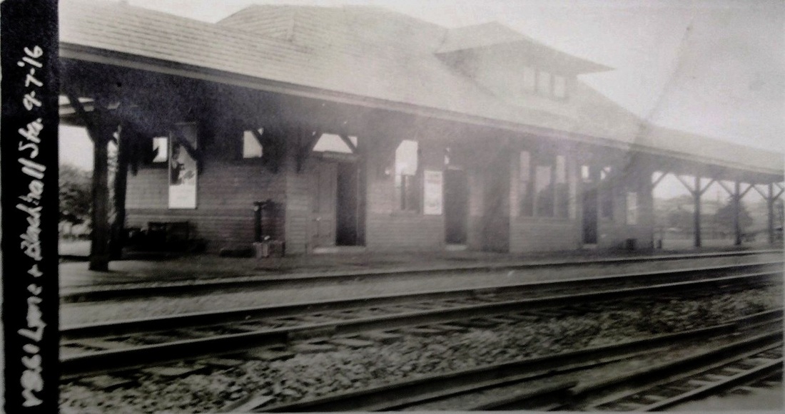
|
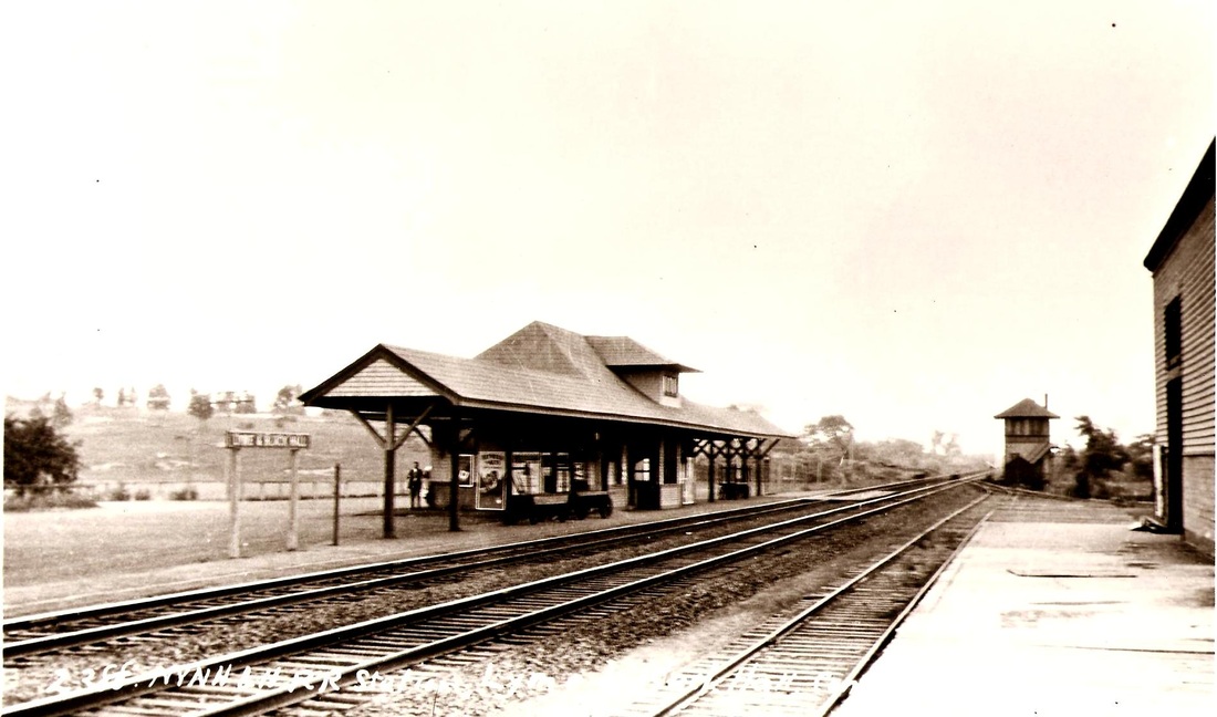
|
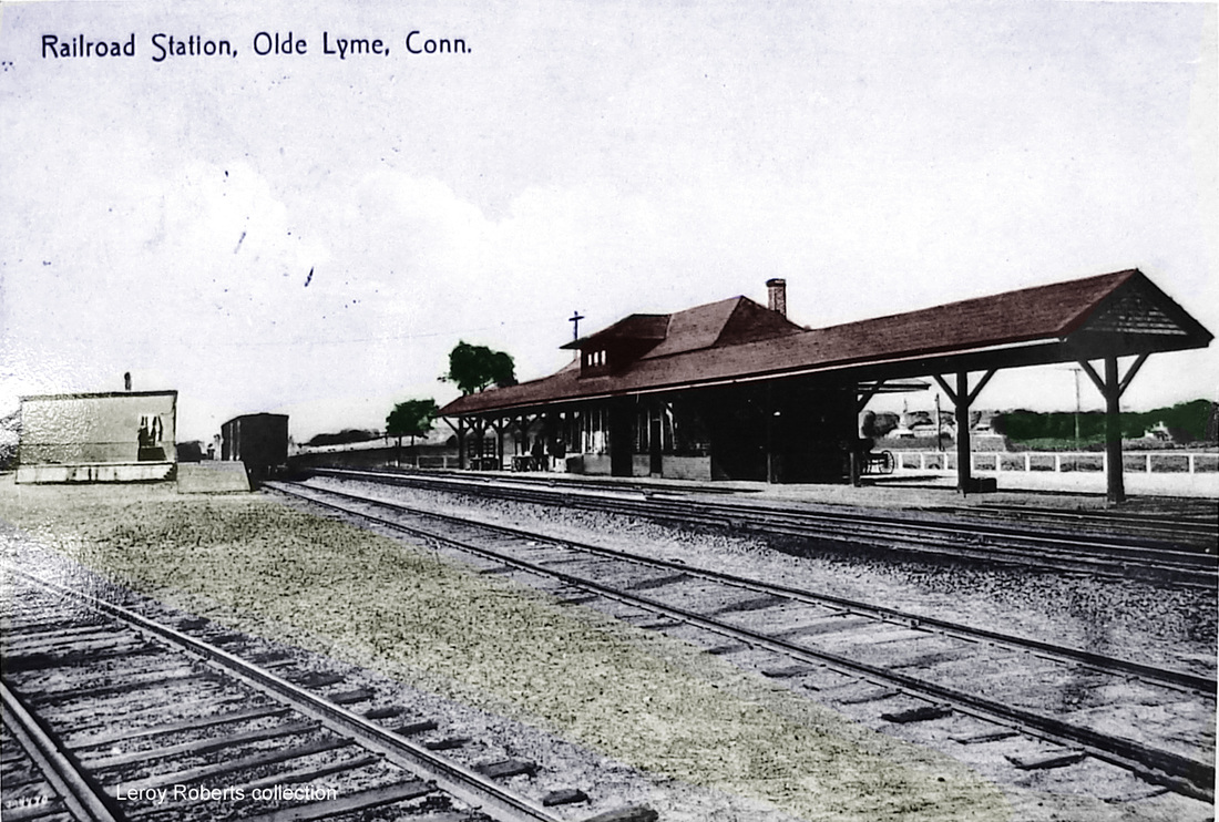
|
LYME3 (AND BLACK HALL) [NYNH&H, 1907]
This station replaced the separate LYME2 and BLACK HALL2 depots in 1907. Even before this, the railroad had begun to petition for combining closely adjacent stops. Permission was refused here earlier in 1906 until the need to realign the ROW for the approach to the new Connecticut River bridge was factored in and approval was given later in the year, with the stipulation that the old stations remain in service until the new one opened. The location at Ways Crossing was 3,000 feet west of BLACK HALL2 and 6,500 feet east of LYME2. The signboard and timetables read LYME AND BLACK HALL though the railroad often referred to this simply by the single name. The structure was "nearing completion" in April, 1907. The new bridge opened on 8/5/1907 and we assume the new LYME3 station was ready for service by that time. The val photo at [1] is dated 9/7/1916. The shot at [2] is a Lewis H. Benton image ca. 1930 and shows that SS 105, the Lyme signal tower, was also relocated eastward from its position on the old ROW. The card at [3] looks west and shows the freight depot on the south side of the track. The card highlights the challenge of referencing this station by name, calling it Olde Lyme, which was correct for the town in which it stood, officially without the quaint 'e' at the end of Old. The architectural plan at [4] calls this depot simply LYME and says was built in 1907. The one daily-except-Sunday train stopping here on our 2/8/1932 timetable is gone on that of 9/29/1935. The 1938 SSRR revised list says this station is being retained for railroad use; its ultimate fate is yet unknown to us. [REFS: RRC38.15,17,18,30 (4/16/1906); HC/03/13/1906/17; HC/04/17/1906/05; HC/04/20/1907/17; HC/07/27/1907/17; SL16.2.9][rev010318]
This station replaced the separate LYME2 and BLACK HALL2 depots in 1907. Even before this, the railroad had begun to petition for combining closely adjacent stops. Permission was refused here earlier in 1906 until the need to realign the ROW for the approach to the new Connecticut River bridge was factored in and approval was given later in the year, with the stipulation that the old stations remain in service until the new one opened. The location at Ways Crossing was 3,000 feet west of BLACK HALL2 and 6,500 feet east of LYME2. The signboard and timetables read LYME AND BLACK HALL though the railroad often referred to this simply by the single name. The structure was "nearing completion" in April, 1907. The new bridge opened on 8/5/1907 and we assume the new LYME3 station was ready for service by that time. The val photo at [1] is dated 9/7/1916. The shot at [2] is a Lewis H. Benton image ca. 1930 and shows that SS 105, the Lyme signal tower, was also relocated eastward from its position on the old ROW. The card at [3] looks west and shows the freight depot on the south side of the track. The card highlights the challenge of referencing this station by name, calling it Olde Lyme, which was correct for the town in which it stood, officially without the quaint 'e' at the end of Old. The architectural plan at [4] calls this depot simply LYME and says was built in 1907. The one daily-except-Sunday train stopping here on our 2/8/1932 timetable is gone on that of 9/29/1935. The 1938 SSRR revised list says this station is being retained for railroad use; its ultimate fate is yet unknown to us. [REFS: RRC38.15,17,18,30 (4/16/1906); HC/03/13/1906/17; HC/04/17/1906/05; HC/04/20/1907/17; HC/07/27/1907/17; SL16.2.9][rev010318]
LYONS [> NORTH BRIDGEPORT]