Track 12: CT Passenger Stations, Q-R
See TCS Home Page links for notes, abbreviations, and sources.
Use Track 11 map link to locate stations, rail and trolley lines, and POIs.
Use Track 11 map link to locate stations, rail and trolley lines, and POIs.
QUAKER HILL [> WATERFORD/W1,W2]

|
|
|

Meriden Historical Society
QUARRY JUNCTION [M&W, 1888]
The name for this Meriden location may not go back to 1888 and probably was not a passenger station but it is nevertheless an interesting railroad meeting point with a history of its own. Later NYNH&H ETTs referred to this point as QUARRY JUNCTION for the fact that the York Hill Quarry about two miles to the east was accessed by the interchange here. The bridge over the NYNH&H was originally constructed in 1888 for the new M&W line to Waterbury. The photo at lower left appears in the history of the successor company, the Meriden, Waterbury & Connecticut River RR, written by Glover A. Snow [click here]. The Consolidated must have been greatly annoyed at this 7/19/1889 incident after it fought long and hard to prevent any crossing of its line by the upstart railroad, claiming at one point in litigation that the property rights on all parcels it owned went from the heavens above down to the center of the Earth below! The photo at upper left looks east toward the bridge in the 1980s and the corroborating shot at middle was taken in 2012. The track to the right heads for the bridge which is just out of sight. The one going left is the interchange track which the Consolidated was forced to accept. It curves to the north to descend down the ridge where the onlookers perched in the accident photo. The bridge stands today off Gracey Ave., still spanning the Amtrak line as seen in our 3/15/2012 northward-looking photo at right. [REFS: SR/05/13/1870/08; CRC37.1889.14: connection; S30][rev040113]
The name for this Meriden location may not go back to 1888 and probably was not a passenger station but it is nevertheless an interesting railroad meeting point with a history of its own. Later NYNH&H ETTs referred to this point as QUARRY JUNCTION for the fact that the York Hill Quarry about two miles to the east was accessed by the interchange here. The bridge over the NYNH&H was originally constructed in 1888 for the new M&W line to Waterbury. The photo at lower left appears in the history of the successor company, the Meriden, Waterbury & Connecticut River RR, written by Glover A. Snow [click here]. The Consolidated must have been greatly annoyed at this 7/19/1889 incident after it fought long and hard to prevent any crossing of its line by the upstart railroad, claiming at one point in litigation that the property rights on all parcels it owned went from the heavens above down to the center of the Earth below! The photo at upper left looks east toward the bridge in the 1980s and the corroborating shot at middle was taken in 2012. The track to the right heads for the bridge which is just out of sight. The one going left is the interchange track which the Consolidated was forced to accept. It curves to the north to descend down the ridge where the onlookers perched in the accident photo. The bridge stands today off Gracey Ave., still spanning the Amtrak line as seen in our 3/15/2012 northward-looking photo at right. [REFS: SR/05/13/1870/08; CRC37.1889.14: connection; S30][rev040113]

Dave Peters Collection
|
National Archives
|

|
|
|
|
QUINEBAUG [BH&E, 1866; opens as NEW BOSTON]
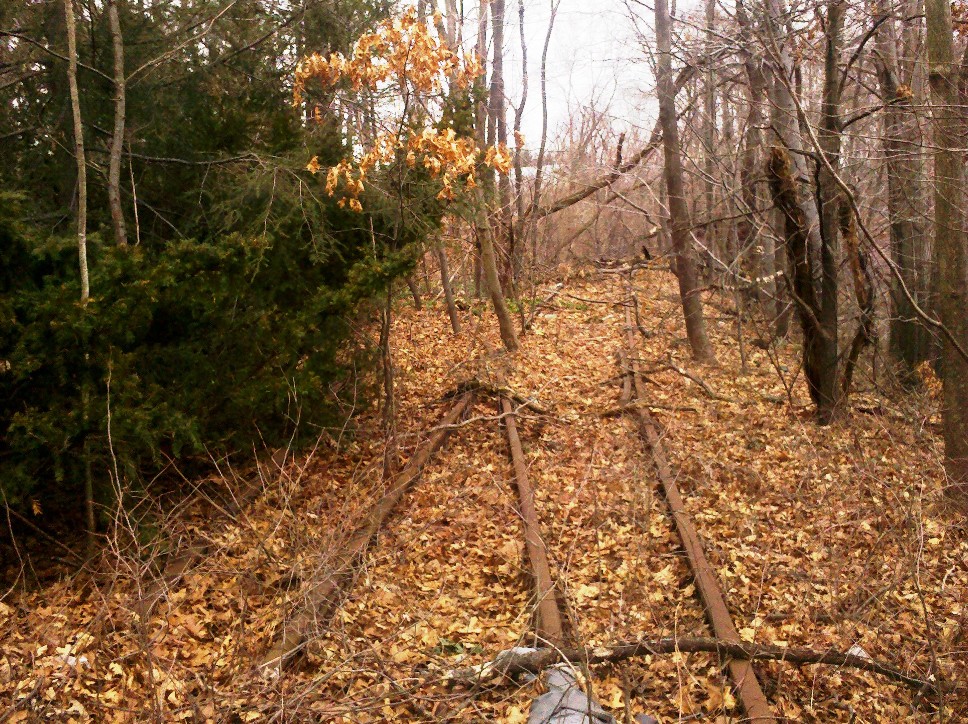
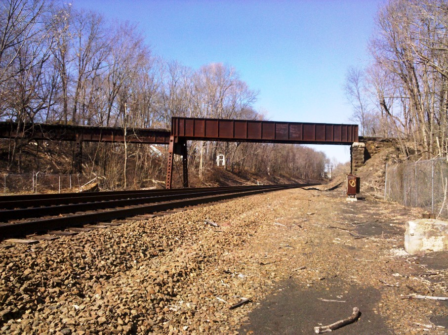
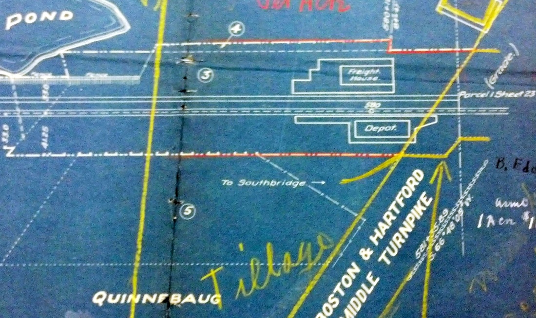
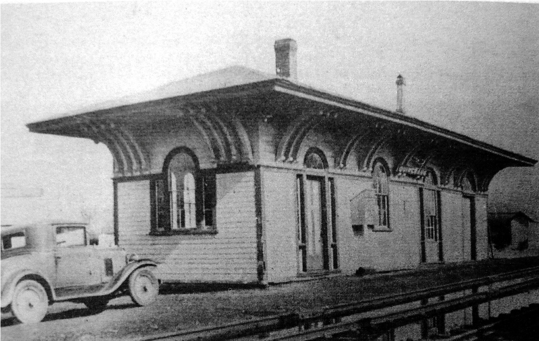
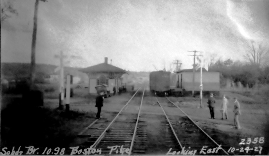
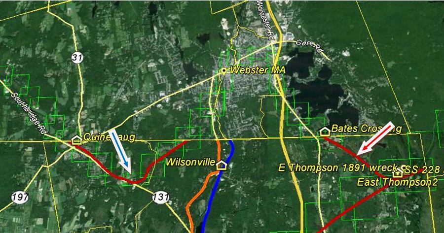
Rails were completed from EAST THOMPSON in 1866 and stopped here until the tracks reached the intended branch terminus at Southbridge in February, 1867. This stop was first called NEW BOSTON and is seen as such on our 1871TT. It became QUINEBAUG, often spelled with two Ns, in 1873, the reported reason for the change being confusion with another Massachusetts town of the same or a similar name, a fact we cannot verify. It appears under its new name on our 1875TT. The ICC valuation photo at [1] is probably dated 4/4/1917, as are many of the others in this area and the valuation map at [2] shows the station layout in 1915. The undated image at [3] shows the freight station south of the track and the passenger station beyond it. The shot at [4] is dated 3/17/1934. At [5] we see the PUC doing their annual inspection on 10/24/1927. This branch crossed the state line twice, creating two segments in each state. The snippet from our Track 11 Google Earth map at [6] shows the eastern segment up to BATES CROSSING at the red arrow and the blue arrow points to the western segment with QUINEBAUG. Southbridge branch passenger service ended on 8/15/1930 and tracks were torn out from East Thompson to Webster in 1937. QUINEBAUG was torn down in 1936. [REFS: BET/01/31/1865/02; NYH/09/24/1866/02; BDA/11/05/1869/02; BPO/08/19/1930/00; K111; SL12.2.13 (1981)][rev121917]
Rails were completed from EAST THOMPSON in 1866 and stopped here until the tracks reached the intended branch terminus at Southbridge in February, 1867. This stop was first called NEW BOSTON and is seen as such on our 1871TT. It became QUINEBAUG, often spelled with two Ns, in 1873, the reported reason for the change being confusion with another Massachusetts town of the same or a similar name, a fact we cannot verify. It appears under its new name on our 1875TT. The ICC valuation photo at [1] is probably dated 4/4/1917, as are many of the others in this area and the valuation map at [2] shows the station layout in 1915. The undated image at [3] shows the freight station south of the track and the passenger station beyond it. The shot at [4] is dated 3/17/1934. At [5] we see the PUC doing their annual inspection on 10/24/1927. This branch crossed the state line twice, creating two segments in each state. The snippet from our Track 11 Google Earth map at [6] shows the eastern segment up to BATES CROSSING at the red arrow and the blue arrow points to the western segment with QUINEBAUG. Southbridge branch passenger service ended on 8/15/1930 and tracks were torn out from East Thompson to Webster in 1937. QUINEBAUG was torn down in 1936. [REFS: BET/01/31/1865/02; NYH/09/24/1866/02; BDA/11/05/1869/02; BPO/08/19/1930/00; K111; SL12.2.13 (1981)][rev121917]
National Archives
|
|
|

|
|
|
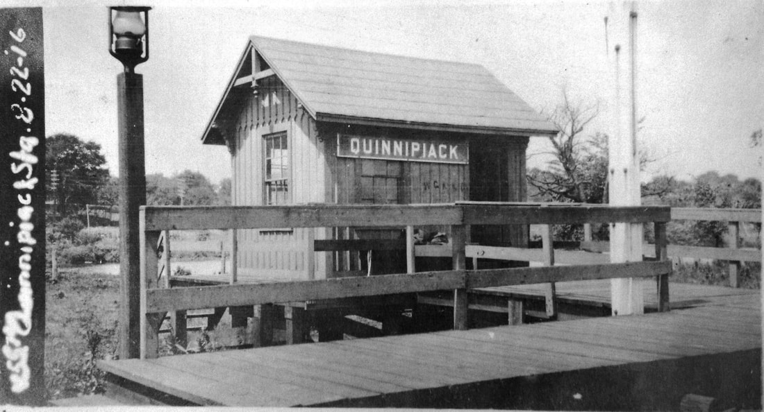
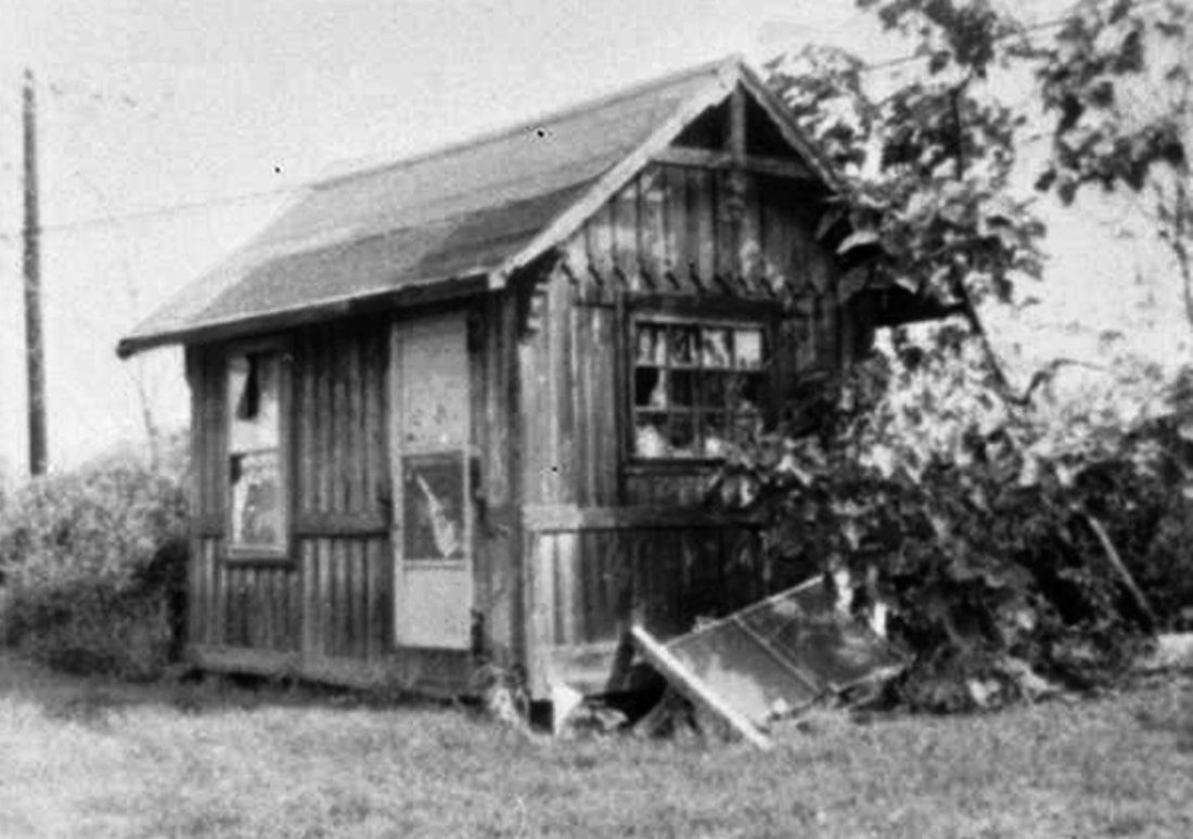
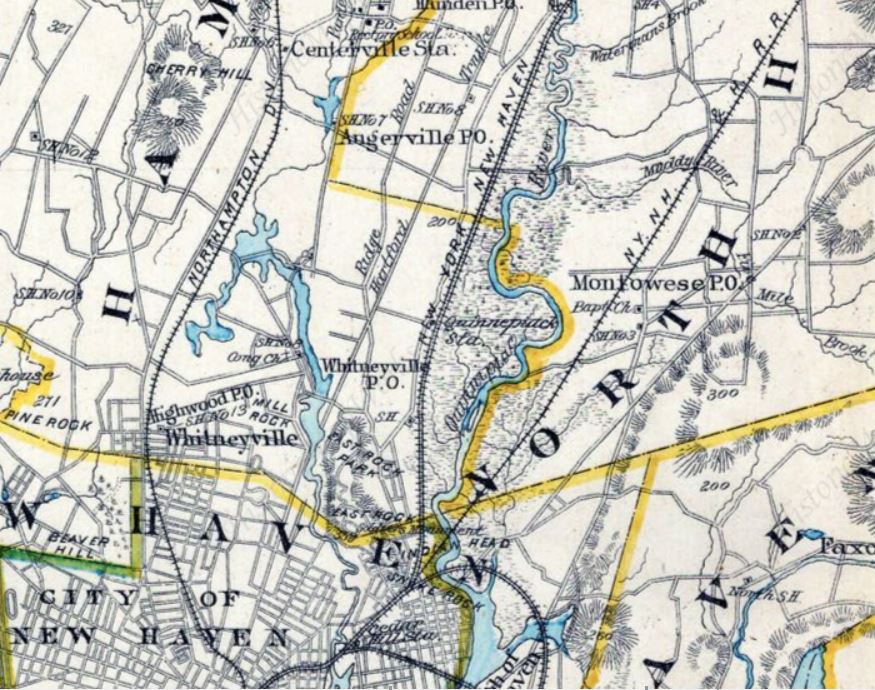
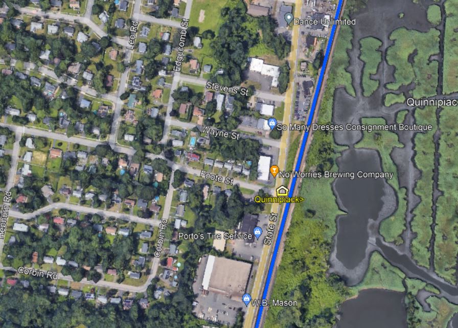
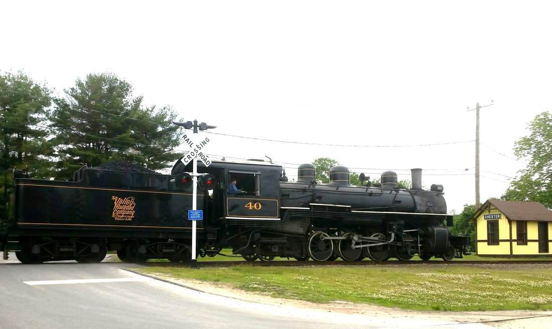
QUINNIPIACK [H&NH, 1871]
This stop in the town of Hamden was created late in 1871 according to a Register article which said that the NYNH&H had just located a new station there, half way between New Haven and North Haven. The article goes on to say that most people would be very surprised to know that the Hamden town border reached as far east as the Quinnipiac River. Though the stop was announced as EAST HAMDEN, apparently the proximity to the nearby river won out, with the variant spelling of QUINNIPIACK. The valuation photo at [1] shows a trackside view on 8/22/1916; note the post at right with wires or ropes for raising and lowering the paddle to stop trains at this flag station. The street-side view at [2] is undated; the structure looks shabby but posters are still up. The 1893 Hurd map at [3] shows the location at dead center and the 6/30/1915 valuation map at [4] shows the footprint. 'FP' stands for frame (wooden) passenger station. On the snippet from our Track 11 Google Earth map at [5], it looks to have stood at the foot (pardon the pun!) of Foote St. where it meets State St. The first newspaper appearance we have found is in 5/30/1872 when the new fare from Hartford to here was listed as 95 cents; no old rate means to us that trains did not stop here much before that time. The stop is clearly mentioned in the newspaper then when a church group from NORTH HAVEN was stopping at this station "a few moments later" on the way to a picnic at the NRR's HIGH ROCK GROVE in Beacon Falls. Interestingly, the NYNH&H cars were to be switched to the NH&D, which was to run a "special train direct to the grove." This sharing of passenger train business is significant because at the time the NH&D was seeking legislative redress for discrimination by the two other roads in freight traffic. See Track 2, MP2.2.2. Passenger service seems to have ended here, as at many other locations, between 1925 and 1928. The QUINNIPIACK structure survives as CHESTER3, having been donated in 1975 to the Valley RR which restored it and placed it at Railroad Ave. and Grote Rd., the former site of CHESTER2. At [6] VRR No. 40 blasts past with a train on 6/9/2018. [REFS: NHER/09/22/1871/02; HC/09/23/1871/03; BDA/09/28/1871/02; HDC/05/31/1872/02; NHER/08/05/1879/04; NHER/07/01/1889/01: wreck on 6/29 just below station; NHER/05/07/1896/01; 12/2/1925 Form 220 LWTT: yes; 11/18/1928 Form 200 TT: no; R84][rev050722]
This stop in the town of Hamden was created late in 1871 according to a Register article which said that the NYNH&H had just located a new station there, half way between New Haven and North Haven. The article goes on to say that most people would be very surprised to know that the Hamden town border reached as far east as the Quinnipiac River. Though the stop was announced as EAST HAMDEN, apparently the proximity to the nearby river won out, with the variant spelling of QUINNIPIACK. The valuation photo at [1] shows a trackside view on 8/22/1916; note the post at right with wires or ropes for raising and lowering the paddle to stop trains at this flag station. The street-side view at [2] is undated; the structure looks shabby but posters are still up. The 1893 Hurd map at [3] shows the location at dead center and the 6/30/1915 valuation map at [4] shows the footprint. 'FP' stands for frame (wooden) passenger station. On the snippet from our Track 11 Google Earth map at [5], it looks to have stood at the foot (pardon the pun!) of Foote St. where it meets State St. The first newspaper appearance we have found is in 5/30/1872 when the new fare from Hartford to here was listed as 95 cents; no old rate means to us that trains did not stop here much before that time. The stop is clearly mentioned in the newspaper then when a church group from NORTH HAVEN was stopping at this station "a few moments later" on the way to a picnic at the NRR's HIGH ROCK GROVE in Beacon Falls. Interestingly, the NYNH&H cars were to be switched to the NH&D, which was to run a "special train direct to the grove." This sharing of passenger train business is significant because at the time the NH&D was seeking legislative redress for discrimination by the two other roads in freight traffic. See Track 2, MP2.2.2. Passenger service seems to have ended here, as at many other locations, between 1925 and 1928. The QUINNIPIACK structure survives as CHESTER3, having been donated in 1975 to the Valley RR which restored it and placed it at Railroad Ave. and Grote Rd., the former site of CHESTER2. At [6] VRR No. 40 blasts past with a train on 6/9/2018. [REFS: NHER/09/22/1871/02; HC/09/23/1871/03; BDA/09/28/1871/02; HDC/05/31/1872/02; NHER/08/05/1879/04; NHER/07/01/1889/01: wreck on 6/29 just below station; NHER/05/07/1896/01; 12/2/1925 Form 220 LWTT: yes; 11/18/1928 Form 200 TT: no; R84][rev050722]
RAWSON [> HAMPTON]
RED BRIDGE [> HANOVER]
RED BRIDGE [> HANOVER]
|
|
|
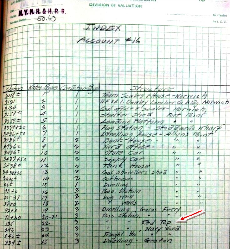
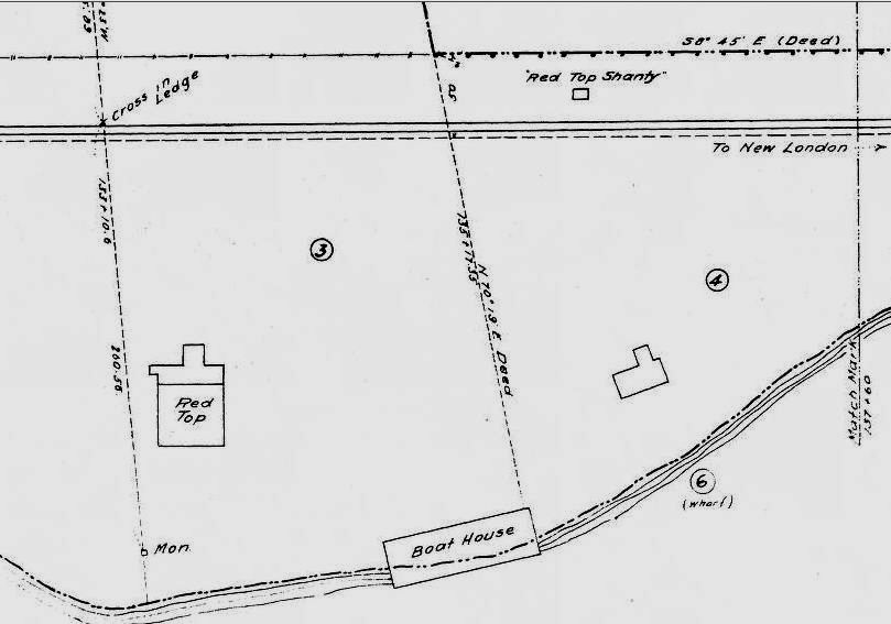
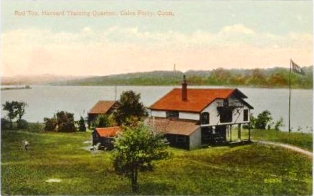
RED TOP [NYNH&H, c1900?]
This was a later stop on the N&W in the town of Ledyard between GALES FERRY and NAVY YARD connected with the annual Yale-Harvard boat races. While the Elis were headquartered at GALES FERRY, the Crimson located just to the south in a structure reportedly built in 1881 with the red roof that occasioned the name. 'Red Top, Conn.' is the dateline location in New York Times articles covering the race in the early 1900s. The Harvard quarters remain at this location today [click here]. A 1900 Register article reads as follows: "Red Top, the Harvard quarters, a half a mile down the river, is deserted but the building and grounds where the crimson will be located after their arrival next week, have ben [sic] put in the neatest condition imaginable for their reception. The New London Board of Trade and the Consolidated railroad have seen that the building was given a number of minor but badly needed repairs and the grounds were cleaned and mowed. Red Top now looks like a well-kept country seat with a carefully trimmed lawn. More visitors than ever before will visit the oarsmen at their quarters this season. They'll take advantage of the new branch of the Consolidated Railroad and the new trolley line from New London to Norwich..." In anticipation of the 1899 opening of the "new branch" from ALLYNS POINT to GROTON, the NYNH&H actually bought the Harvard crew property in 1898 and apparently leased it to the team thereafter, which might explain why the railroad is fixing up the property in 1900. In spite of all this early activity, RED TOP is not seen as a timetable stop even in the 1907 Official List. We catch it for the first time in the ICC's 1916 field notes and it is gone by the 1923 Official List. With later service cutbacks on the N&W line, perhaps Harvard continued to have rail access by special arrangement. The ICC labels RED TOP a passenger station on the field-notes index page at left, not a 'shelter shed' like FORT POINT or a 'flag station' like STODDARDS WHARF and the val map at right shows a 'Red Top shanty,' as well as the quarters building and boathouse. We will recheck on our next trip to the National Archives for a photo or more detailed information on this station, as well has how to decipher the terminology that the ICC used for labeling structures. [REFS: NHER/06/18/1888/01; NYT/06/28/1893/09; HC/09/12/1898/09; NHER/06/07/1900/01; 1907OL: no; 1919ICC: yes; 1923OL: no][rev1210312]
This was a later stop on the N&W in the town of Ledyard between GALES FERRY and NAVY YARD connected with the annual Yale-Harvard boat races. While the Elis were headquartered at GALES FERRY, the Crimson located just to the south in a structure reportedly built in 1881 with the red roof that occasioned the name. 'Red Top, Conn.' is the dateline location in New York Times articles covering the race in the early 1900s. The Harvard quarters remain at this location today [click here]. A 1900 Register article reads as follows: "Red Top, the Harvard quarters, a half a mile down the river, is deserted but the building and grounds where the crimson will be located after their arrival next week, have ben [sic] put in the neatest condition imaginable for their reception. The New London Board of Trade and the Consolidated railroad have seen that the building was given a number of minor but badly needed repairs and the grounds were cleaned and mowed. Red Top now looks like a well-kept country seat with a carefully trimmed lawn. More visitors than ever before will visit the oarsmen at their quarters this season. They'll take advantage of the new branch of the Consolidated Railroad and the new trolley line from New London to Norwich..." In anticipation of the 1899 opening of the "new branch" from ALLYNS POINT to GROTON, the NYNH&H actually bought the Harvard crew property in 1898 and apparently leased it to the team thereafter, which might explain why the railroad is fixing up the property in 1900. In spite of all this early activity, RED TOP is not seen as a timetable stop even in the 1907 Official List. We catch it for the first time in the ICC's 1916 field notes and it is gone by the 1923 Official List. With later service cutbacks on the N&W line, perhaps Harvard continued to have rail access by special arrangement. The ICC labels RED TOP a passenger station on the field-notes index page at left, not a 'shelter shed' like FORT POINT or a 'flag station' like STODDARDS WHARF and the val map at right shows a 'Red Top shanty,' as well as the quarters building and boathouse. We will recheck on our next trip to the National Archives for a photo or more detailed information on this station, as well has how to decipher the terminology that the ICC used for labeling structures. [REFS: NHER/06/18/1888/01; NYT/06/28/1893/09; HC/09/12/1898/09; NHER/06/07/1900/01; 1907OL: no; 1919ICC: yes; 1923OL: no][rev1210312]

|
|
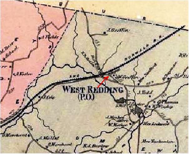
REDDING1 [D&N, 1852]
Seen west of the track on the 1856FC map at left, the stop was established in 1852 when the D&N opened. The 1868 map on the right not only has that first 'station' shown, but it also shows a 'depot' on the east side of the track, probably indicating the structure that we have now listed as REDDING2. Just what the first station looked like, we do not know. Also called WEST REDDING for the section of the town where the railroad built, this stop would receive passengers for the camp meeting ground nearby, later transformed by the D&N into BROOKSIDE PARK. [rev040113]
Seen west of the track on the 1856FC map at left, the stop was established in 1852 when the D&N opened. The 1868 map on the right not only has that first 'station' shown, but it also shows a 'depot' on the east side of the track, probably indicating the structure that we have now listed as REDDING2. Just what the first station looked like, we do not know. Also called WEST REDDING for the section of the town where the railroad built, this stop would receive passengers for the camp meeting ground nearby, later transformed by the D&N into BROOKSIDE PARK. [rev040113]
Max Miller Collection
|

|
Archives & Spec. Colls., UCoon Libraries
|

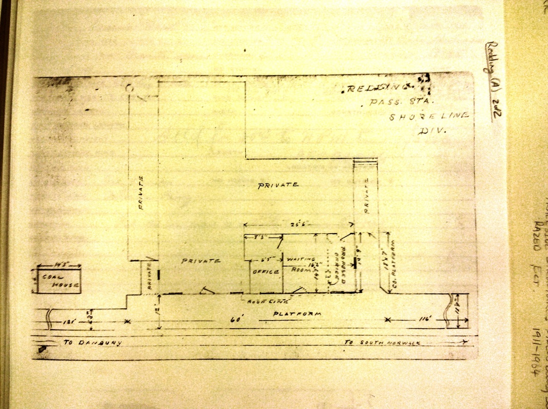
REDDING2 [D&N, c1864]
Brent Colley [click here] says this structure, which would serve for nearly a century as the depot, was built in 1864 and that is plausible for making it too late to appear on the 1856FC map but in time to be seen on the 1868 map, both shown in our previous entry. This building has gone through a succession of owners and remodelings and worn many hats over the years, serving as general store, post office, railroad station, private residence, and rental apartments. A Danbury News article mentions that the station agent, Mr. Mandeville, was living upstairs when the Brookside Hotel across the track caught fire on 11/3/1882. The PUC photo at upper left likely dates to 1928 and the one at middle shows Emory P. Sanford as the proprietor, after taking over ca. 1914. The floor plan at right shows the arrangement of the depot wing, the dating of which addition is not clear. The colorful shot at lower left shows a bay window added to the south wall of the old depot space and being operated as a liquor store after REDDING3 was built to the south in 1952. Currently, in 2011, REDDING2 houses a cafe and a church. [REFS: DN/11/8/1882/01; R84; SL17.4.26][rev071515]
Brent Colley [click here] says this structure, which would serve for nearly a century as the depot, was built in 1864 and that is plausible for making it too late to appear on the 1856FC map but in time to be seen on the 1868 map, both shown in our previous entry. This building has gone through a succession of owners and remodelings and worn many hats over the years, serving as general store, post office, railroad station, private residence, and rental apartments. A Danbury News article mentions that the station agent, Mr. Mandeville, was living upstairs when the Brookside Hotel across the track caught fire on 11/3/1882. The PUC photo at upper left likely dates to 1928 and the one at middle shows Emory P. Sanford as the proprietor, after taking over ca. 1914. The floor plan at right shows the arrangement of the depot wing, the dating of which addition is not clear. The colorful shot at lower left shows a bay window added to the south wall of the old depot space and being operated as a liquor store after REDDING3 was built to the south in 1952. Currently, in 2011, REDDING2 houses a cafe and a church. [REFS: DN/11/8/1882/01; R84; SL17.4.26][rev071515]

REDDING3 [NYNH&H, 1952]
This may be the structure that the NYNH&H built in 1952, probably on the expiration of the agreement for use of REDDING2. John Roy describes this as "a no-frills concrete block passenger shelter" so either we have the wrong building or it has been dressed up by the time this undated photo was taken. [REFS: R84]
This may be the structure that the NYNH&H built in 1952, probably on the expiration of the agreement for use of REDDING2. John Roy describes this as "a no-frills concrete block passenger shelter" so either we have the wrong building or it has been dressed up by the time this undated photo was taken. [REFS: R84]
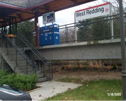
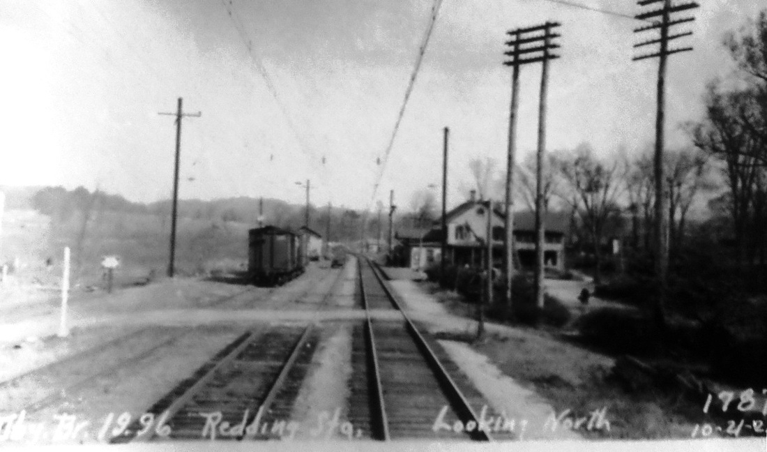
REDDING4 [MN, 1999]
Now located south of Long Ridge Rd. on the west side of the track and afforded a large parking lot, this high-level platform has been in use since 1999. The stop is now known as WEST REDDING. [rev040113]
Now located south of Long Ridge Rd. on the west side of the track and afforded a large parking lot, this high-level platform has been in use since 1999. The stop is now known as WEST REDDING. [rev040113]
REEDS GAP [NHM&W, 1870]
We are not sure whether this location was ever a passenger stop on the NHM&W after it opened in 1870. It was the site of a notable cut, comparable to the one at Allingtown on the NH&D that was 55 feet deep. Rock is quarried here even today along Rte 68 in Durham.
We are not sure whether this location was ever a passenger stop on the NHM&W after it opened in 1870. It was the site of a notable cut, comparable to the one at Allingtown on the NH&D that was 55 feet deep. Rock is quarried here even today along Rte 68 in Durham.

|

|
|
|

|
|
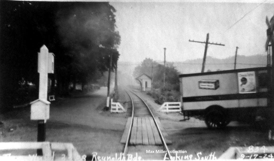
REYNOLDS BRIDGE [NRR, c1864]
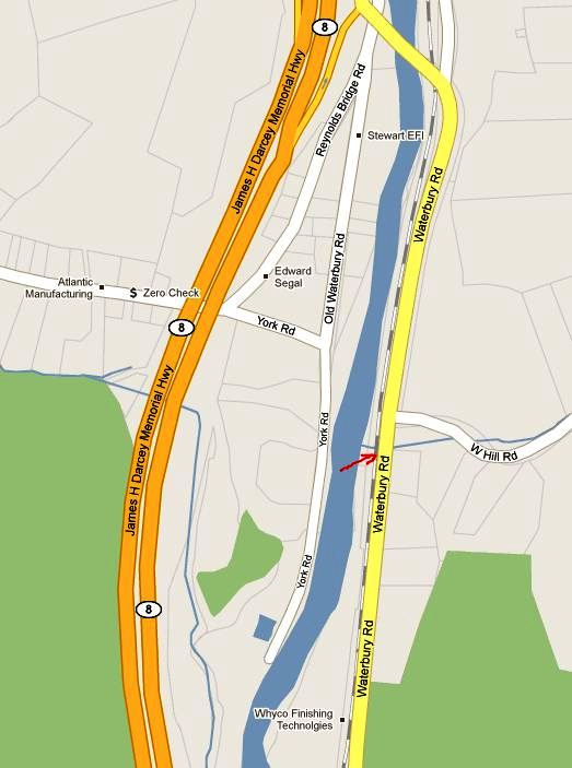
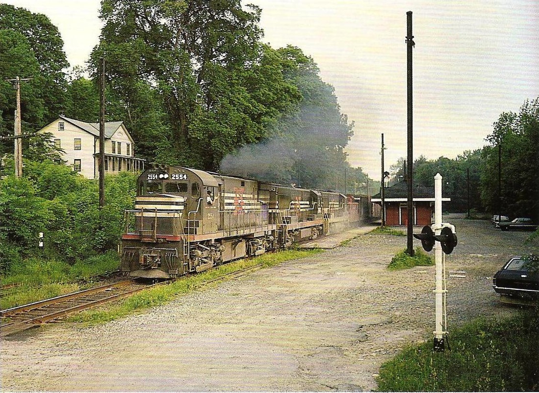
The first listing we have for this station in the town of Watertown is in 1864, and though its timetable appearance thereafter is a bit erratic as a flag stop, it is on all the RRM maps from 1876 onward. The photo at [1] is undated. Al Weaver colorized the shot at [2], making the station more easily visible. We think the view looks south from the west side of the river. In the foreground is the trolley line from Thomaston, which crossed the river just south of here, as seen highlighted in yellow on the map from the book Waterbury Trolleys at [4]. The NRR itself recrossed the river to the east side where the station is seen below its namesake highway bridge. The 9/17/1924 PUC photo at [3] looks south on the at the station on the west side of the NRR track. REYNOLDS BRIDGE is still on the official list of 1923 but is gone in 1928. According to materials in the Leroy Roberts Collection, soon to be at UConn, the 10x15-ft, slate-roofed structure was moved here on 5/8/1925 to serve as CAMPVILLE3, replacing the depot that had just burned there. A 1926 Courant article tells us that REYNOLDS BRIDGE, BURRVILLE, CAMPVILLE, EAST LITCHFIELD and FLUTEVILLE were about to lose their passenger trains in 1926, likely due to trolley competition. All service from Waterbury to Winsted was being reduced to two round trips by steam train and four by gas rail car, with the yard at the latter place being closed "as no trains are to lie over there" any more. The 1892 topo map at [5] pinpoints the location of this station. The red arrow shows the same point on the present day map at [6]. The 'new' Reynolds Bridge crossing is seen at the top of that map where it spans both the railroad track and the river. The beautiful concrete arch structure, still in use today, opened on 5/18/1928. [REFS: NYH/11/27/1870/07; HDC/05/12/1876/01; CRC34.1886.57; SR/09/10/1896/07; HC/12/13/1906/15; HC/06/20/1926/A12; HC/05/13/1928/03; D89] [rev100112, 110820]
RICHARDS GROVE [> WATERFORD/C2]

|

|
|
RIDGEFIELD1 [D&N, 1852, opens as BEERS STATION]
The first depot in this town was known as BEERS STATION or RIDGEFIELD STATION is the white house on the hillock above the track and the later station. Seen on the 1856FC map, this stop was on the D&N main line at the point that would become known as BRANCHVILLE [see B stations] when the Ridgefield branch was opened in 1870. Initially the railroad intended to build a depot here, but then decided to rent space instead. Sherman Beers, who had already made land available for the right of way, leased "the front two rooms in the basement in the dwelling house now occupied by me, together with the room or office between the said front two rooms and now occupied as a bar room... for the uses and privileges of a passenger house and ticket office for said railroad company." While we need to verify the source of the quoted material, we thank Brent Colley [click here] who submitted it and Jack Sanders [click here], on whose research this is based in part. [REFS: RP/07/06/1981/??]
The first depot in this town was known as BEERS STATION or RIDGEFIELD STATION is the white house on the hillock above the track and the later station. Seen on the 1856FC map, this stop was on the D&N main line at the point that would become known as BRANCHVILLE [see B stations] when the Ridgefield branch was opened in 1870. Initially the railroad intended to build a depot here, but then decided to rent space instead. Sherman Beers, who had already made land available for the right of way, leased "the front two rooms in the basement in the dwelling house now occupied by me, together with the room or office between the said front two rooms and now occupied as a bar room... for the uses and privileges of a passenger house and ticket office for said railroad company." While we need to verify the source of the quoted material, we thank Brent Colley [click here] who submitted it and Jack Sanders [click here], on whose research this is based in part. [REFS: RP/07/06/1981/??]
|
|

historyofredding.com
|
|
|

Max Miller Collection
|
 Mike Grace photo
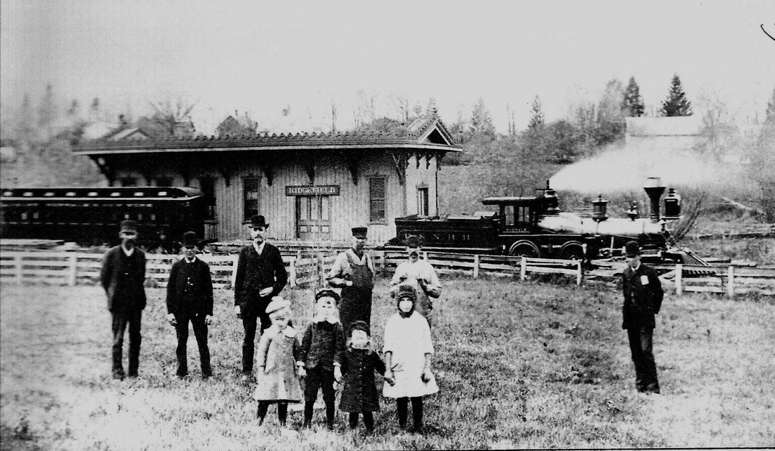
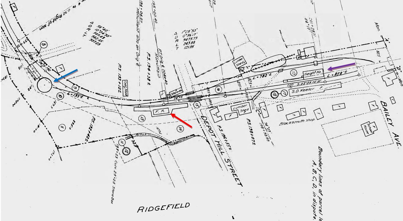
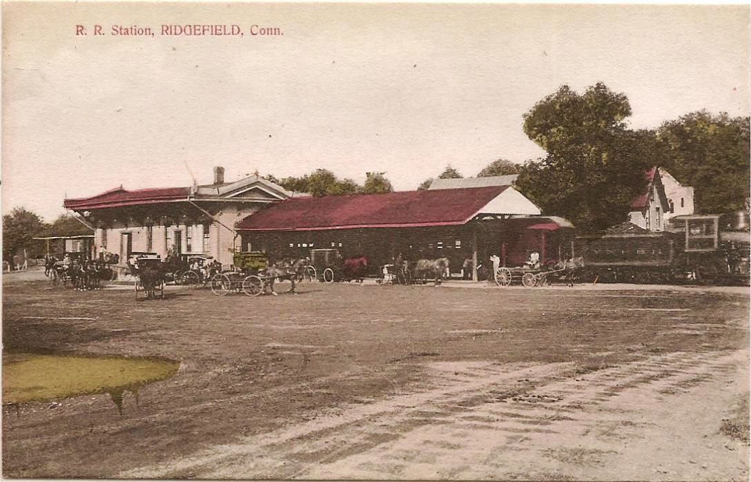
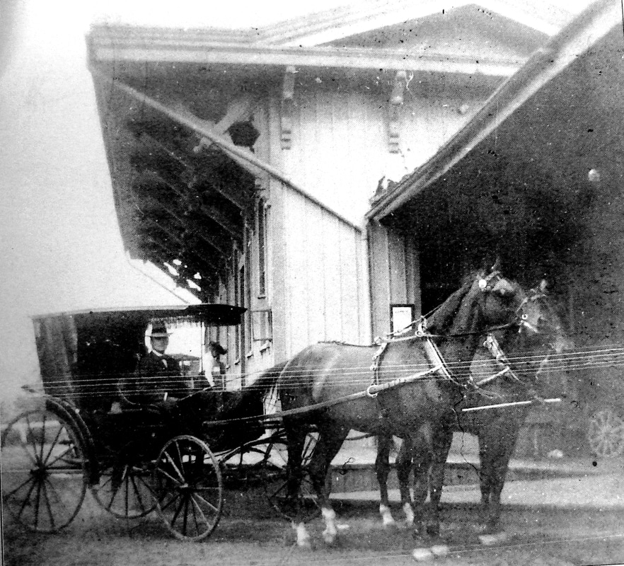
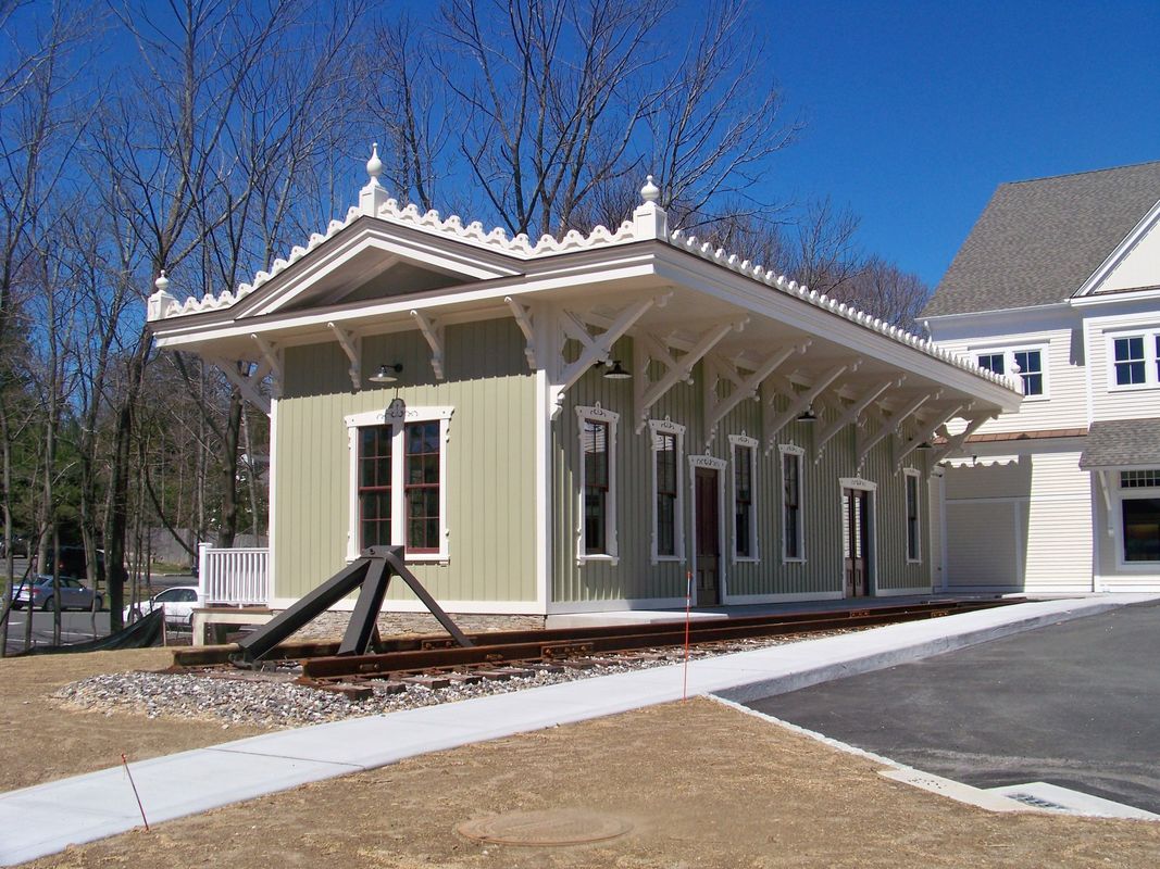
RIDGEFIELD2 [D&N, 1870]
This depot was built in the center of town in 1870 as the terminus of the new line from the D&N main where RIDGEFIELD1 then became BRANCHVILLE1. The photo at [1] probably shows the station near the time of opening. The tall, derby-hatted gentleman in the center is said to be John Bacon, D&N superintendent and later a state railroad commissioner. Note the stack on the wood-burner which is releasing a sizeable plume of steam! Compass-north is to the left on the 1915 val map at [2] with the station [red arrow] on the west side of the track at what was then called Depot Hill St., now Prospect St. End of track is just south of the freight house, which is at the purple arrow. Trains in [3] and [4] are both face south, the engines presumably to be run in reverse to turntable [blue arrow] north of station. A surrey with the fringe on top awaits a train at [5]. The 11/20/1924 PUC shot at [6] looks compass-north but is labeled as looking south; we think the negative is reversed. Here the station is on the left (compass-west) with a train in the shadows and a store house on the right. John Roy gives 8/8/1925 as the last date of railroad use, part of the severe passenger service cutbacks of that year and Cornwall has a photo of a NETCo bus then serving the station in 1926. NYNH&H real estate records show the structure was sold on 10/31/1946 to the Ridgefield Supply Co. According to the Ridgefield Historical Society, the building had the rainwater-fed cistern on the flat roof above the waiting room in later days. RIDGEFIELD2 was razed in September, 2015 because it reportedly was too deteriorated to save. The full-size replica at [7] debuted in September, 2017 as part of Ridgefield Supply's renovation program. It may not be the original and not in the same precise location, but it is a nice homage to the building that served as the town's railroad station for over 70 years. Thanks to Mike Grace and Dana Laird for their input. [REFS: R85; SL17.4.28][rev041017, 111018, 041023]
This depot was built in the center of town in 1870 as the terminus of the new line from the D&N main where RIDGEFIELD1 then became BRANCHVILLE1. The photo at [1] probably shows the station near the time of opening. The tall, derby-hatted gentleman in the center is said to be John Bacon, D&N superintendent and later a state railroad commissioner. Note the stack on the wood-burner which is releasing a sizeable plume of steam! Compass-north is to the left on the 1915 val map at [2] with the station [red arrow] on the west side of the track at what was then called Depot Hill St., now Prospect St. End of track is just south of the freight house, which is at the purple arrow. Trains in [3] and [4] are both face south, the engines presumably to be run in reverse to turntable [blue arrow] north of station. A surrey with the fringe on top awaits a train at [5]. The 11/20/1924 PUC shot at [6] looks compass-north but is labeled as looking south; we think the negative is reversed. Here the station is on the left (compass-west) with a train in the shadows and a store house on the right. John Roy gives 8/8/1925 as the last date of railroad use, part of the severe passenger service cutbacks of that year and Cornwall has a photo of a NETCo bus then serving the station in 1926. NYNH&H real estate records show the structure was sold on 10/31/1946 to the Ridgefield Supply Co. According to the Ridgefield Historical Society, the building had the rainwater-fed cistern on the flat roof above the waiting room in later days. RIDGEFIELD2 was razed in September, 2015 because it reportedly was too deteriorated to save. The full-size replica at [7] debuted in September, 2017 as part of Ridgefield Supply's renovation program. It may not be the original and not in the same precise location, but it is a nice homage to the building that served as the town's railroad station for over 70 years. Thanks to Mike Grace and Dana Laird for their input. [REFS: R85; SL17.4.28][rev041017, 111018, 041023]
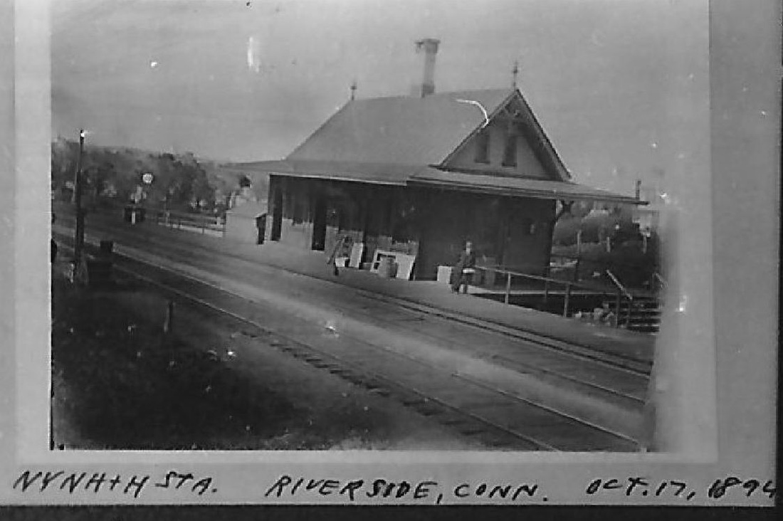
RIVERSIDE1 [NY&NH, 1869, WB]
This stop on the east side of Cos Cob harbor in the town of Greenwich was established in 1869. A February, 1869 newspaper article said: "The New York and New Haven Railroad Company intend rebuilding that section of the bridge at Cos Cob, which was destroyed by fire about three [sic] ago. The materials will be of wood and iron, put together in the most substantial manner. The company also intends erecting at Riverside, at the eastern end of Cos Cob bridge, a fine brick passenger depot." Also mentioned in the Register in 1872, it is seen in timetables thereafter as well. This photo shows a sizeable structure and the 1894 date is supported by the two-track main line that would be doubled in size shortly. It looks to us like that station, true to its name, is situated on the riverbank itself, with the railing for the bridge across the harbor seen right behind it. That would put it on the westbound side of the tracks. [REFS: CC/02/27/1869/02; CR/06/08/1872/03; CRC29.1882.103; NHER/06/09/1882/01; NHER/05/13/1893/04; NHER/07/17/1894/01; R85][rev011813]
This stop on the east side of Cos Cob harbor in the town of Greenwich was established in 1869. A February, 1869 newspaper article said: "The New York and New Haven Railroad Company intend rebuilding that section of the bridge at Cos Cob, which was destroyed by fire about three [sic] ago. The materials will be of wood and iron, put together in the most substantial manner. The company also intends erecting at Riverside, at the eastern end of Cos Cob bridge, a fine brick passenger depot." Also mentioned in the Register in 1872, it is seen in timetables thereafter as well. This photo shows a sizeable structure and the 1894 date is supported by the two-track main line that would be doubled in size shortly. It looks to us like that station, true to its name, is situated on the riverbank itself, with the railing for the bridge across the harbor seen right behind it. That would put it on the westbound side of the tracks. [REFS: CC/02/27/1869/02; CR/06/08/1872/03; CRC29.1882.103; NHER/06/09/1882/01; NHER/05/13/1893/04; NHER/07/17/1894/01; R85][rev011813]

|
|
RIVERSIDE2 [NYNH&H, c1895, WB]
This is a 1930 val photo of this station that was built ca. 1895 on the westbound side of the tracks. According to the Register, the four-tracking work was to begin in this area on July 18, 1894, with J.K. Ryan, the same contractor who was building the new Shore Line cut-off in Fair Haven, getting the job. The 1915 val map shows the salt-box station at our red arrow, standing a little farther away from the bridge than its predecessor did. This depot apparently stood until it was burned in an arson fire set by teenaged volunteer firemen in 1975. [REFS: NHER/07/17/1894/01; NHER/01/18/1897/01; HC/01/23/1975/68; NYT/01/23/1975/30; HC/03/07/1975/04][rev011813]
This is a 1930 val photo of this station that was built ca. 1895 on the westbound side of the tracks. According to the Register, the four-tracking work was to begin in this area on July 18, 1894, with J.K. Ryan, the same contractor who was building the new Shore Line cut-off in Fair Haven, getting the job. The 1915 val map shows the salt-box station at our red arrow, standing a little farther away from the bridge than its predecessor did. This depot apparently stood until it was burned in an arson fire set by teenaged volunteer firemen in 1975. [REFS: NHER/07/17/1894/01; NHER/01/18/1897/01; HC/01/23/1975/68; NYT/01/23/1975/30; HC/03/07/1975/04][rev011813]
|
|
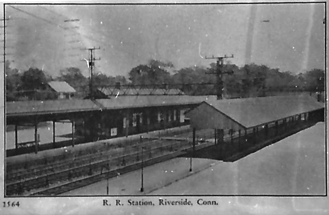
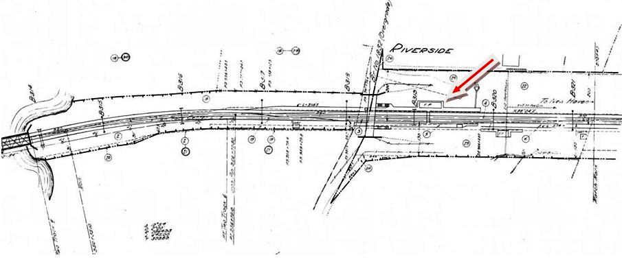
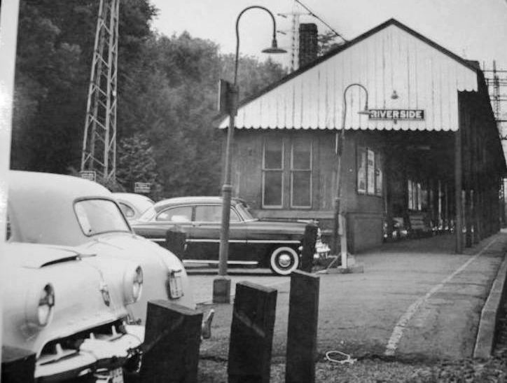
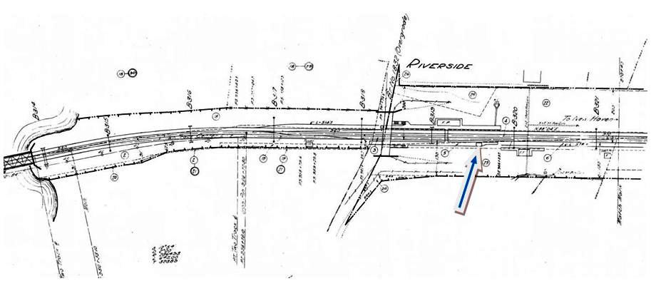
RIVERSIDE3 [NYNH&H, c1895, EB]
A new, canopied platform and small station on the eastbound side were put up at the time of the four-tracking. The station is seen in the photo at upper left and, though unmarked on the 1915 val map [add011813] at upper right, our blue arrow points to its footprint. The covered platform is on the right in the postcard view at lower left and RIVERSIDE2 is visible across the tracks on the westbound side. The old eastbound depots at most stops on the New York line were demolished by 1974 with the debut of the high-level platforms and M2 commuter cars. [REFS: HC/05/23/1974/95D][rev011813]
A new, canopied platform and small station on the eastbound side were put up at the time of the four-tracking. The station is seen in the photo at upper left and, though unmarked on the 1915 val map [add011813] at upper right, our blue arrow points to its footprint. The covered platform is on the right in the postcard view at lower left and RIVERSIDE2 is visible across the tracks on the westbound side. The old eastbound depots at most stops on the New York line were demolished by 1974 with the debut of the high-level platforms and M2 commuter cars. [REFS: HC/05/23/1974/95D][rev011813]

RIVERSIDE4 [PC, c1975, WB]
This brick structure was built on the westbound side to replace RIVERSIDE2. Based on the fact that the fire was in 1975, we have had to extend John Roy's 1945-1965 date range for this structure. No newspaper articles have been found on the actual opening, which may not have been until sometime after 1975. [REFS: R85] [rev011813]
This brick structure was built on the westbound side to replace RIVERSIDE2. Based on the fact that the fire was in 1975, we have had to extend John Roy's 1945-1965 date range for this structure. No newspaper articles have been found on the actual opening, which may not have been until sometime after 1975. [REFS: R85] [rev011813]

RIVERSIDE5 [MN, 1990s, EB]
Shelter built in the 1990s on eastbound side of tracks to replace RIVERSIDE3.
Shelter built in the 1990s on eastbound side of tracks to replace RIVERSIDE3.

Dave Peters Collection
|

|
Max Miller Collection
|

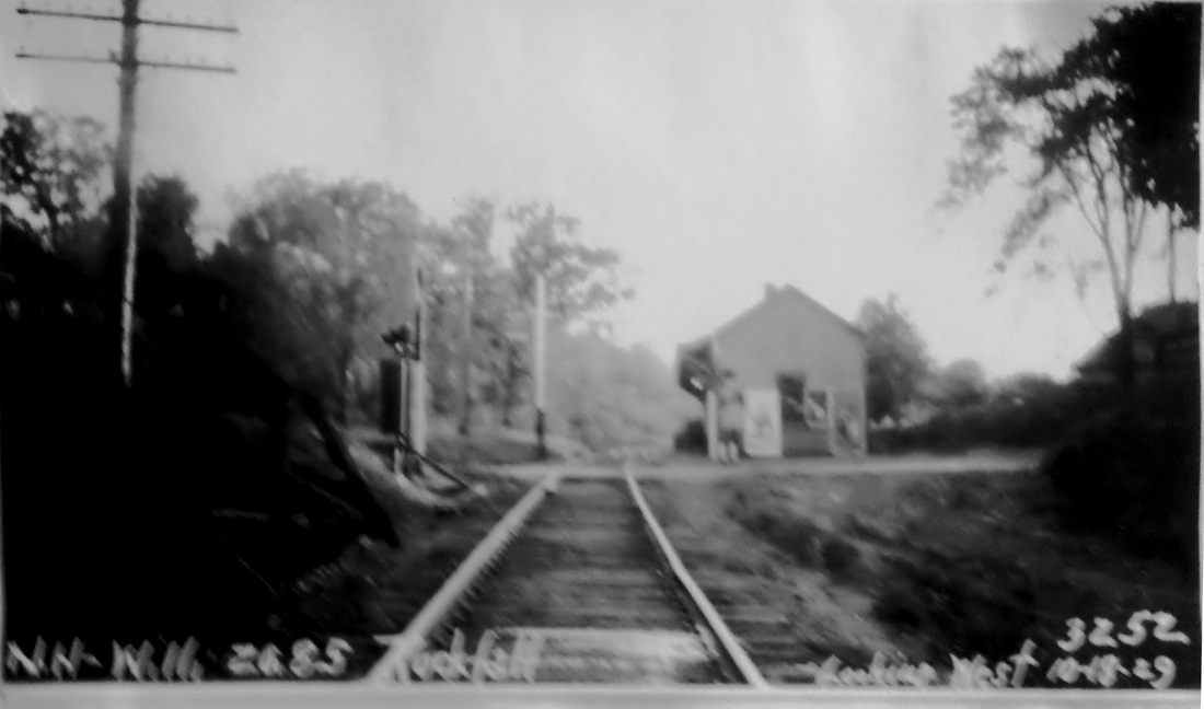
ROCKFALL [NHM&W, 1870]
This stop was established in 1870 by the NHM&W. The approach to this station was on a high bridge [lower left] over the Coginchaug River just south of the depot and today located in Wadsworth Falls State Park. The 3/15/1939 SSRR addendum says this station is being retained for less-than-carload service. [REFS: HDC/08/25/1871/02; SL22.4.29][rev010518]
This stop was established in 1870 by the NHM&W. The approach to this station was on a high bridge [lower left] over the Coginchaug River just south of the depot and today located in Wadsworth Falls State Park. The 3/15/1939 SSRR addendum says this station is being retained for less-than-carload service. [REFS: HDC/08/25/1871/02; SL22.4.29][rev010518]

Dave Peters Collection
|

|
ROCKVILLE [RRR, 1863]
This was the terminus of the Rockville RR in the village of that name in the town of Vernon. According to the Courant, most of the branch track was laid, the depot was nearly finished, and workmen were laying the foundation for a 75-ft long freight house in early July, 1863. There was talk of the possibility of a new depot in 1903 when wires were being strung for the trolley operation to Hartford and Melrose, but we have never seen any photos of a station other than this one, which we have to conclude is the one built in 1863. The 3/15/1939 SSRR addendum says this station has been retained and is partly rented to Express Co. Its ultimate fate is not yet known to us. [REFS: HDC/07/02/1863/02; CRC43.1895.23; HC/03/03/1903/02][rev010518]
This was the terminus of the Rockville RR in the village of that name in the town of Vernon. According to the Courant, most of the branch track was laid, the depot was nearly finished, and workmen were laying the foundation for a 75-ft long freight house in early July, 1863. There was talk of the possibility of a new depot in 1903 when wires were being strung for the trolley operation to Hartford and Melrose, but we have never seen any photos of a station other than this one, which we have to conclude is the one built in 1863. The 3/15/1939 SSRR addendum says this station has been retained and is partly rented to Express Co. Its ultimate fate is not yet known to us. [REFS: HDC/07/02/1863/02; CRC43.1895.23; HC/03/03/1903/02][rev010518]
ROCKVILLE JUNCTION [> WEST STREET]
ROCKY HILL1 [CV, 1871]
This was apparently an old house that had been in use presumably from 1871 when the CV opened and replacement was called for in 1888. [REFS: PP/03/01/1888/01; PP/03/06/1888/01; HDC/03/07/1888/06][rev122022]
ROCKY HILL1 [CV, 1871]
This was apparently an old house that had been in use presumably from 1871 when the CV opened and replacement was called for in 1888. [REFS: PP/03/01/1888/01; PP/03/06/1888/01; HDC/03/07/1888/06][rev122022]

Dave Peters Collection
|
|
ROCKY HILL2 [NYNH&H, 1892]
The 3/15/1939 SSRR addendum says this station was partly rented and, if removed, it would necessary to find agent quarters in another building, likely the freight house, and relocate the block signal. The 7/19/1940 addendum says the station had been sold on 9/30/1939 and would be remaining on railroad land. [REFS: HC/12/01/1891/06: work begun on new station; CRC41.1893.20: has been erected; R86]
The 3/15/1939 SSRR addendum says this station was partly rented and, if removed, it would necessary to find agent quarters in another building, likely the freight house, and relocate the block signal. The 7/19/1940 addendum says the station had been sold on 9/30/1939 and would be remaining on railroad land. [REFS: HC/12/01/1891/06: work begun on new station; CRC41.1893.20: has been erected; R86]
Washington Historical Society
|

National Archives
|
|
Litchfield Historical Society
|
Litchfield Historical Society
|
|
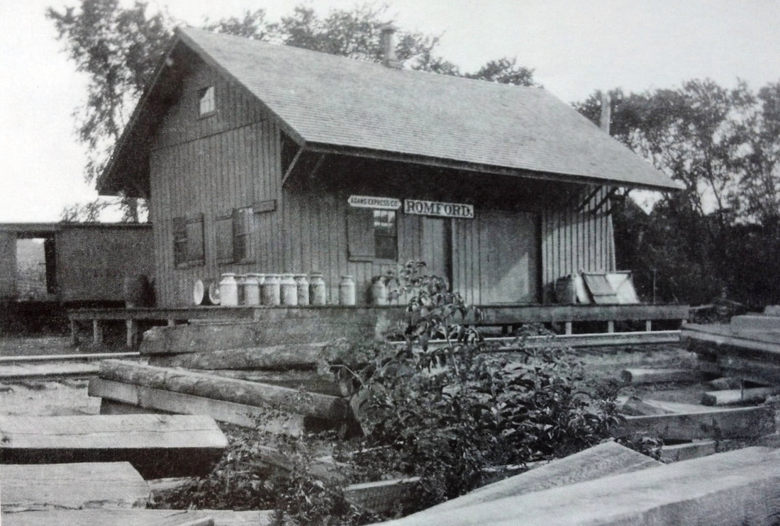
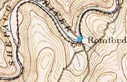
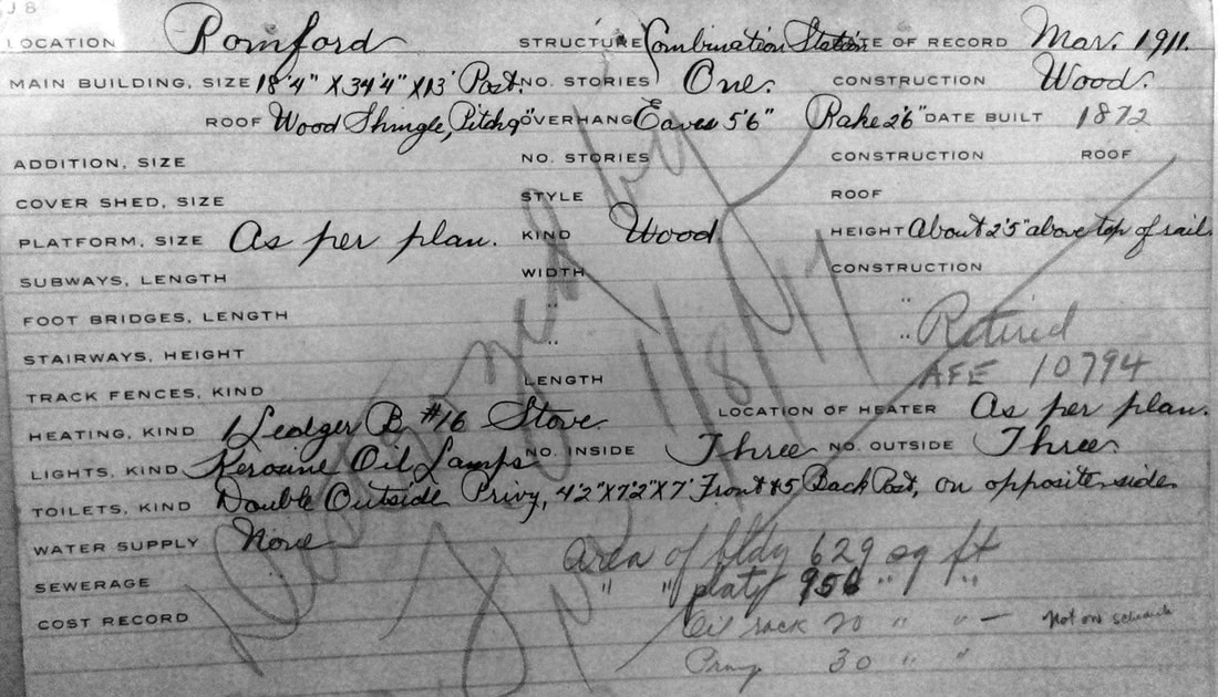
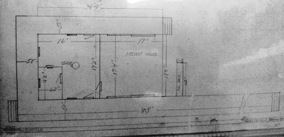
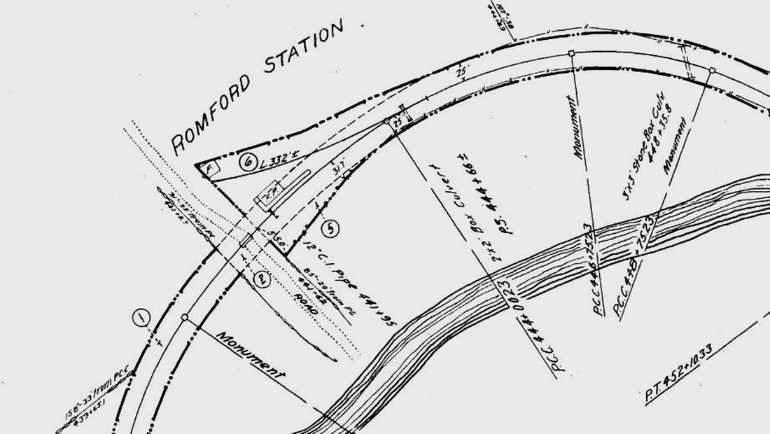
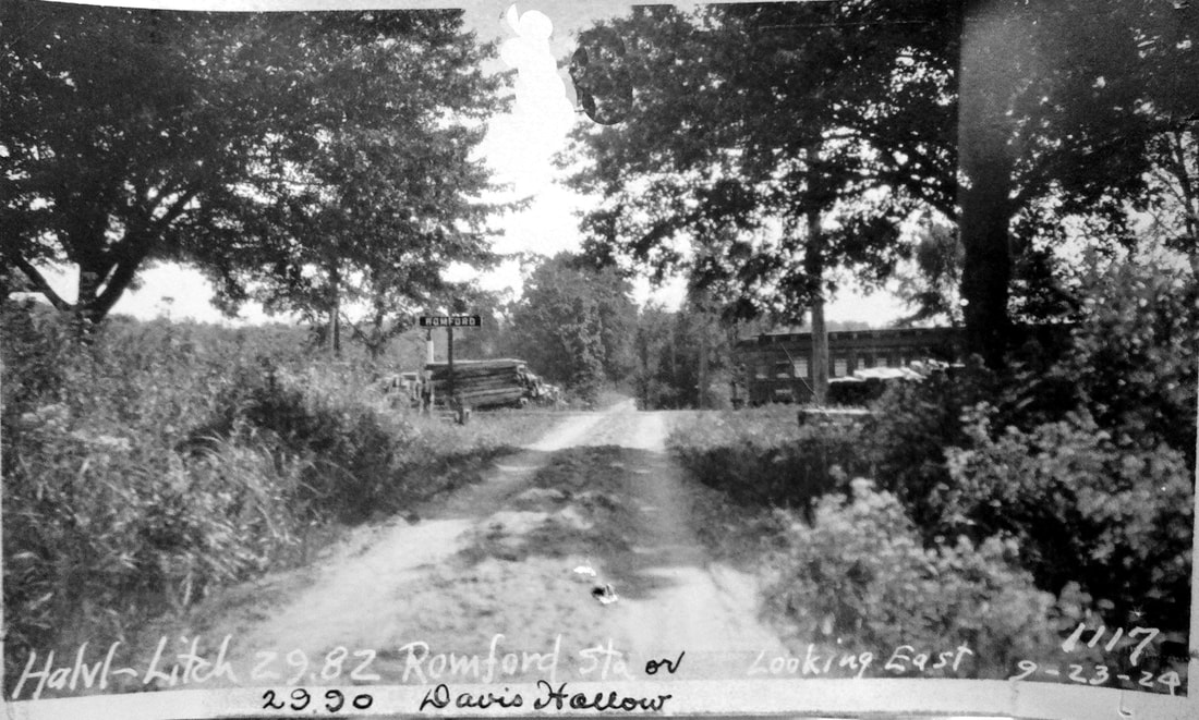
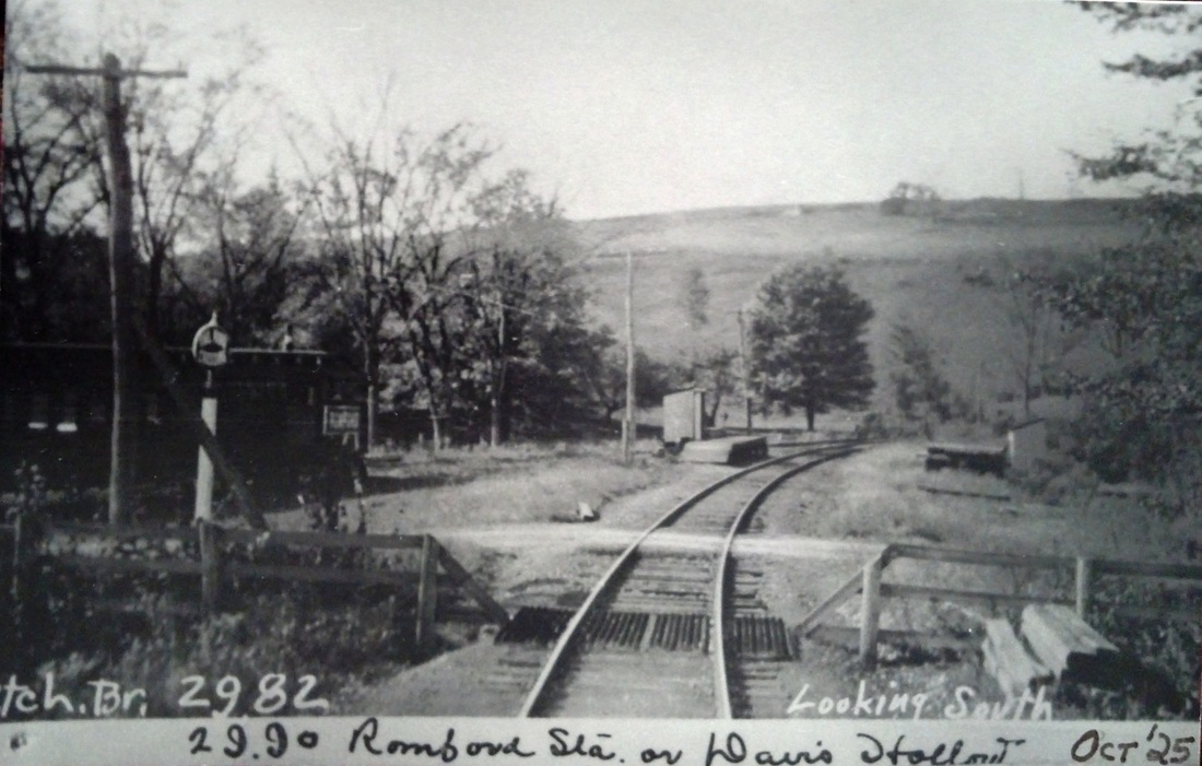
ROMFORD1 [SV, 1872]
This basic combination depot was built in the town of Washington when the Shepaug Valley RR opened in 1872. It was named for the land donation by Romulous Ford who owned the area then known as Davi(e)s Hollow. A Romsford Station post office was established on 9/6/1872 and lasted until 2/15/1926. In a freak lightning storm on 6/4/1876 "... electric fluid following the wire about a mile..." traveled from a nearby farm to the depot roof, and thence knocked agent Archer Ford unconscious and onto the track as a train was approaching. He was pulled to safety in time but his "... right side and arm were scathed by the fluid...," the hope being that he was not paralyzed. The newspaper added... "Surely there is but a step between us and death." The ubiquitous Bee tells us that the platform was extended in 1906, "... making it much more convenient for passengers to get on and off the train." Bob Lord is apparently off a bit when he says that the station burned in the 1920s. In the Shepaug railroad collection, donated to the Litchfield Historical Society by retired railroader Ed Brady, there is a real estate card that says this station was destroyed by fire on 1/8/1917. No newspaper article to corroborate this date has yet been found.
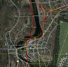
IMAGES: [1] 1905 shot with milk cans lining the platform; note boxcar on house track behind the station. [2] 10/10/1916 ICC valuation photo; Lord notes new porch added. [3] 1892 topographic map. [4,5] 3/1911 real estate card, front and back. [6] 6/30/1915 ICC valuation map; south at top, station was in southwest corner of grade crossing.
REFERENCES: LEN/08/06/1876/02; CR/06/10/1876/02; NBE/09/02/1898/08; NBE/11/16/1906/08; NBE/11/13/1903/07; NBE/01/31/1908/15; D151; post office: Y226.
TCS REVISIONS: 4/1/2013, 6/8/2022
This basic combination depot was built in the town of Washington when the Shepaug Valley RR opened in 1872. It was named for the land donation by Romulous Ford who owned the area then known as Davi(e)s Hollow. A Romsford Station post office was established on 9/6/1872 and lasted until 2/15/1926. In a freak lightning storm on 6/4/1876 "... electric fluid following the wire about a mile..." traveled from a nearby farm to the depot roof, and thence knocked agent Archer Ford unconscious and onto the track as a train was approaching. He was pulled to safety in time but his "... right side and arm were scathed by the fluid...," the hope being that he was not paralyzed. The newspaper added... "Surely there is but a step between us and death." The ubiquitous Bee tells us that the platform was extended in 1906, "... making it much more convenient for passengers to get on and off the train." Bob Lord is apparently off a bit when he says that the station burned in the 1920s. In the Shepaug railroad collection, donated to the Litchfield Historical Society by retired railroader Ed Brady, there is a real estate card that says this station was destroyed by fire on 1/8/1917. No newspaper article to corroborate this date has yet been found.
IMAGES: [1] 1905 shot with milk cans lining the platform; note boxcar on house track behind the station. [2] 10/10/1916 ICC valuation photo; Lord notes new porch added. [3] 1892 topographic map. [4,5] 3/1911 real estate card, front and back. [6] 6/30/1915 ICC valuation map; south at top, station was in southwest corner of grade crossing.
REFERENCES: LEN/08/06/1876/02; CR/06/10/1876/02; NBE/09/02/1898/08; NBE/11/16/1906/08; NBE/11/13/1903/07; NBE/01/31/1908/15; D151; post office: Y226.
TCS REVISIONS: 4/1/2013, 6/8/2022
McCoid/Wooding Collection
|
Max Miller Collection
|
McCoid/Wooding Collection
|
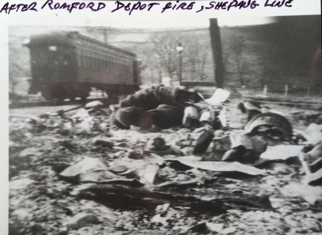
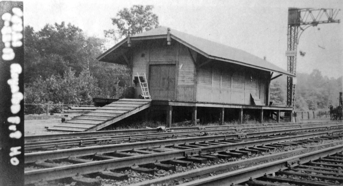
ROMFORD2 [NYNH&H, 1917]
Lord says the immediate replacement station after the fire was a passenger coach, for how long we do not know. Newspaper articles in 1914 said ROMFORD and MORRIS to be discontinued for reasons of economy but this stop lasted to between 1923 and 1928. All passenger service on the Shepaug ended in 1930 and freight service lasted until the line was abandoned in 1948 and the track was taken up. No railroad structures remained for for removal or retirement at this stop by the 1938 SSRR.
IMAGES: [1] 1/8/1917 fire aftermath looking west, railroad-south toward Hawleyville. Only depot chimney remains; temporary coach-station on house track. [2] 9/3/1924 PUC photo, coach is at right. [3] 10/1925 PUC shot looks north; coach to the left, out of service; small waiting shed on a raised platform serves as ROMFORD2.
REFERENCES: NMB/11/03/1914/03; Form220 LWTT 12/2/1923: yes; Form200 11/8/1928: no; 1938 SSRR: no; D151; K60
TCS REVISIONS: 4/1/2013, 6/8/2022
ROSSITERVILLE [> BURRVILLE]

C. Dunn Collection
|
ICC Collection, National Archives
|

|

|
|
ROWAYTON1 [NY&NH, 1867, EB]
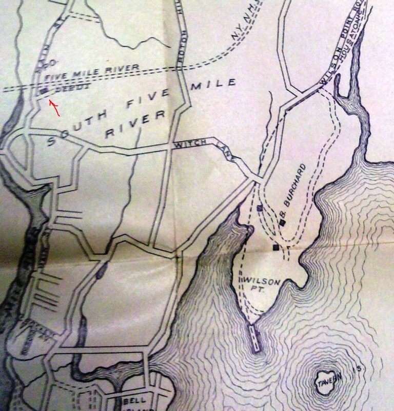
This section of Norwalk was originally known as Five Mile River, or South Five Mile River, for the waterway that empties into Long Island Sound here. Locals approached the railroad commissioners in 1866 to order the NY&NH to establish a station here but were told that the commissioners had no statutory power to give such an order. The railroad, however, acquiesced shortly thereafter, with the Columbian Register reporting in May, 1867 that "a new railway station has just been constructed on the New York and New Haven R.R., between Norwalk and Darien. It is called Rowayton. Resolutions of thanks to the New Haven road, Supt. Hoyt, and Capt. Godfrey, were unanimously passed, as well as to Mr. Vincent Colyer." Godfrey, a NY&NH director was "specially complimented" and may have been the the real force behind this move. In 1868, the Courant calls this stop SOUTH MILE RIVER, leaving out the FIVE that is seen on the ca. 1876 map at lower left. The map demonstrates an ambiguity, seen here and at other stations as well, with differing names for the post office and the railroad station. This confusion was likely part of the reason area residents were meeting precisely at this time to consider what the village should be called. To further add to the difficulty, the RRMs call this stop FIVE MILE RIVER until 1883 when they start listing both names, sometimes making them look like separate stops. There at least is agreement between the 1876 map and the 1893 map [lower middle] showing that the first depot was on the south, eastbound, side of the tracks. Our top left photograph, a rare view, thus looks toward New Haven some time between 1867 and the four-tracking of 1894. The 1917 val photo at top right shows ROWAYTON1, now on the north (westbound) side of the track, elevated on a higher foundation and converted to use as the freight house. On the 1938 SSRR list, this building is to be disposed of. The ca. 1900 city directory map at lower right shows the larger area and nearby WILSON POINT. [REFS: RRC5.23 (9/11/1866); SR/04/25/1867/04; CC/04/27/1867/03; CR/05/04/1867/02; NYHT/05/27/1867/06; HDC/03/09/1868/04; NYHT/05/22/1869/04; HDC/06/22/1871/04; 1871TT; HDC/08/22/1872/01; CRC21.1874.59; NHJC/07/11/1879/02; RRM1882; RRM1883; 1894TT; SA/11/16/2011/00][rev010518]
This section of Norwalk was originally known as Five Mile River, or South Five Mile River, for the waterway that empties into Long Island Sound here. Locals approached the railroad commissioners in 1866 to order the NY&NH to establish a station here but were told that the commissioners had no statutory power to give such an order. The railroad, however, acquiesced shortly thereafter, with the Columbian Register reporting in May, 1867 that "a new railway station has just been constructed on the New York and New Haven R.R., between Norwalk and Darien. It is called Rowayton. Resolutions of thanks to the New Haven road, Supt. Hoyt, and Capt. Godfrey, were unanimously passed, as well as to Mr. Vincent Colyer." Godfrey, a NY&NH director was "specially complimented" and may have been the the real force behind this move. In 1868, the Courant calls this stop SOUTH MILE RIVER, leaving out the FIVE that is seen on the ca. 1876 map at lower left. The map demonstrates an ambiguity, seen here and at other stations as well, with differing names for the post office and the railroad station. This confusion was likely part of the reason area residents were meeting precisely at this time to consider what the village should be called. To further add to the difficulty, the RRMs call this stop FIVE MILE RIVER until 1883 when they start listing both names, sometimes making them look like separate stops. There at least is agreement between the 1876 map and the 1893 map [lower middle] showing that the first depot was on the south, eastbound, side of the tracks. Our top left photograph, a rare view, thus looks toward New Haven some time between 1867 and the four-tracking of 1894. The 1917 val photo at top right shows ROWAYTON1, now on the north (westbound) side of the track, elevated on a higher foundation and converted to use as the freight house. On the 1938 SSRR list, this building is to be disposed of. The ca. 1900 city directory map at lower right shows the larger area and nearby WILSON POINT. [REFS: RRC5.23 (9/11/1866); SR/04/25/1867/04; CC/04/27/1867/03; CR/05/04/1867/02; NYHT/05/27/1867/06; HDC/03/09/1868/04; NYHT/05/22/1869/04; HDC/06/22/1871/04; 1871TT; HDC/08/22/1872/01; CRC21.1874.59; NHJC/07/11/1879/02; RRM1882; RRM1883; 1894TT; SA/11/16/2011/00][rev010518]
|
|

|
Dana Laird Collection
|
Dana Laird Collection
|

|
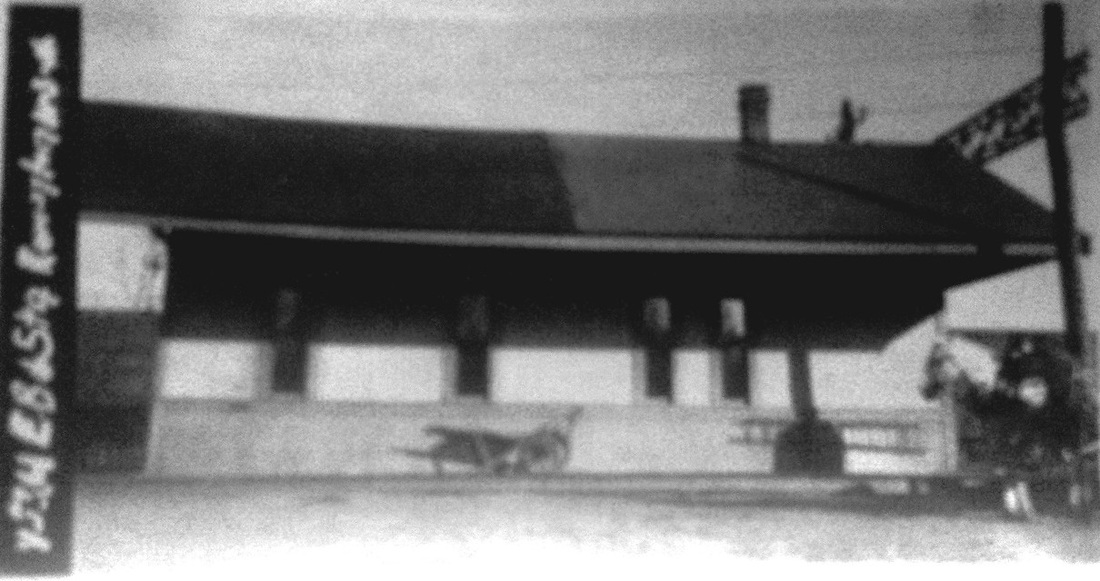
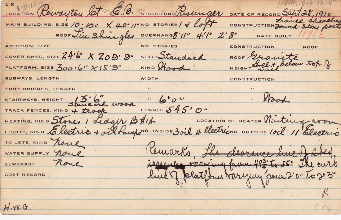
ROWAYTON2 [NYNH&H, 1896, EB]
This small station was built with the four-tracking. The val photo at [1] shows this structure without its covershed on 11/3/1916. Covershed added in the meantime, the PUC shot at [2] taken on 2/25/1931 looks west toward Stamford. The 1915 val map [3] shows this station south of the track and ROWAYTON4 north of the track. The images at [4] and [5] are from the 1910 real estate field card. The 1896 build date is on the front in red pencil and the reverse side has a sketch of the floor plan.The photo at [6] is an eastward-looking view of what was left of this station in the 1950s, once again without the covershed, and probably not too long before the station was removed.[rev040113]
This small station was built with the four-tracking. The val photo at [1] shows this structure without its covershed on 11/3/1916. Covershed added in the meantime, the PUC shot at [2] taken on 2/25/1931 looks west toward Stamford. The 1915 val map [3] shows this station south of the track and ROWAYTON4 north of the track. The images at [4] and [5] are from the 1910 real estate field card. The 1896 build date is on the front in red pencil and the reverse side has a sketch of the floor plan.The photo at [6] is an eastward-looking view of what was left of this station in the 1950s, once again without the covershed, and probably not too long before the station was removed.[rev040113]
ROWAYTON3 [NYNH&H, 1896, WB]
This must have been a station on the westbound side that was replaced in 1910. We have not yet learned what happened to it or what it looked like. [REFS: NHER/08/23/1895/01]
This must have been a station on the westbound side that was replaced in 1910. We have not yet learned what happened to it or what it looked like. [REFS: NHER/08/23/1895/01]
|

|

|

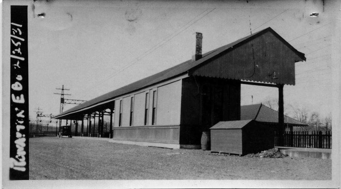
ROWAYTON4 [NYNH&H, 1910]
With terra cotta walls and Spanish tile roof, this was the station mentioned as being under construction in the 1909 annual report. A fortunate find in the Harrisburg Patriot in April, 1910 says this station was up by that time, thus nailing the date down more firmly. The paper was commenting on the new kind of construction material when it reported that the NYNH&H "recently built a hollow tile station at Rowayton, Conn.," and that other railroads like the Lehigh Valley and the DL&W were doing the same. In addition to being fireproof, these new structures were said to be cooler in the summer and warmer in the winter because of the 'dead air' within the hollow blocks. The Pawtucket Times added that these buildings were more economical in the long run because of savings in maintenance and repairs over wood and had lower insurance premiums because they were fireproof. It also said that new stations in Connecticut, our CEDAR HILL3 and TERRYVILLE2, had been built similarly, as had ones at Barnstable, Foxboro and North Scituate in the Bay State. As captured in the image at upper right, ROWAYTON4 was one of two, the other being NOROTON, in 1955 to get platform canopies designed by famed World Trade Center architect Minoru Yamasaki. The lower left photo was taken in 2011. [REFS: NHAR38.1909.7; HP/04/25/1910/05; PT/02/19/1912/01; R86] [rev072516]
With terra cotta walls and Spanish tile roof, this was the station mentioned as being under construction in the 1909 annual report. A fortunate find in the Harrisburg Patriot in April, 1910 says this station was up by that time, thus nailing the date down more firmly. The paper was commenting on the new kind of construction material when it reported that the NYNH&H "recently built a hollow tile station at Rowayton, Conn.," and that other railroads like the Lehigh Valley and the DL&W were doing the same. In addition to being fireproof, these new structures were said to be cooler in the summer and warmer in the winter because of the 'dead air' within the hollow blocks. The Pawtucket Times added that these buildings were more economical in the long run because of savings in maintenance and repairs over wood and had lower insurance premiums because they were fireproof. It also said that new stations in Connecticut, our CEDAR HILL3 and TERRYVILLE2, had been built similarly, as had ones at Barnstable, Foxboro and North Scituate in the Bay State. As captured in the image at upper right, ROWAYTON4 was one of two, the other being NOROTON, in 1955 to get platform canopies designed by famed World Trade Center architect Minoru Yamasaki. The lower left photo was taken in 2011. [REFS: NHAR38.1909.7; HP/04/25/1910/05; PT/02/19/1912/01; R86] [rev072516]
ROWAYTON5 [MN, 1990s]
Built in the 1990s for Metro-North. [REFS: HC/05/23/1974/95D]
Built in the 1990s for Metro-North. [REFS: HC/05/23/1974/95D]

|
|
|
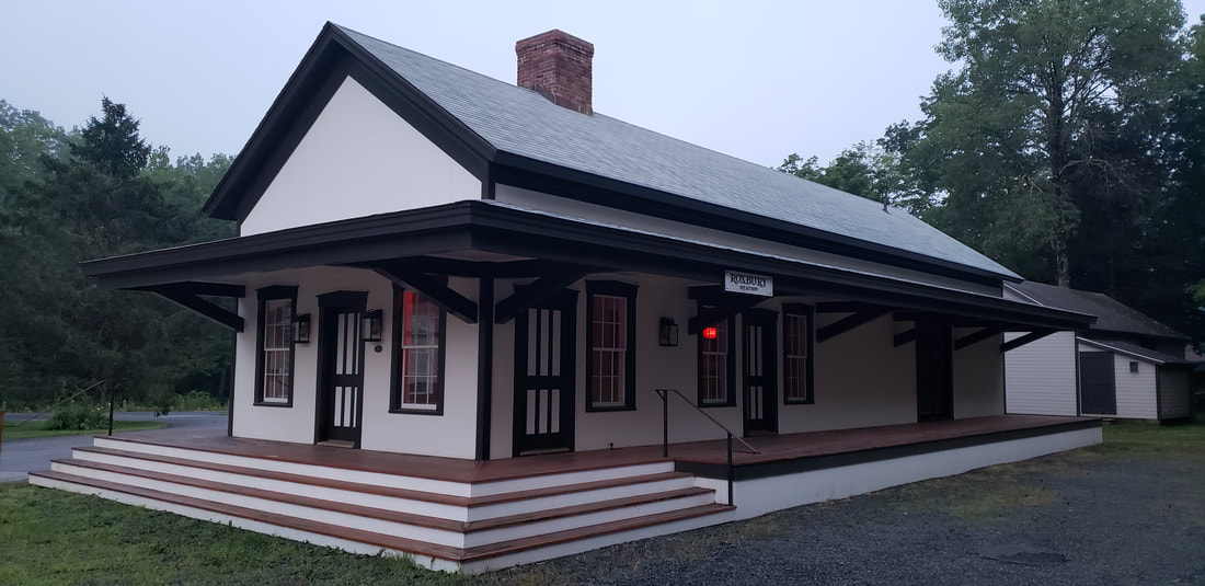
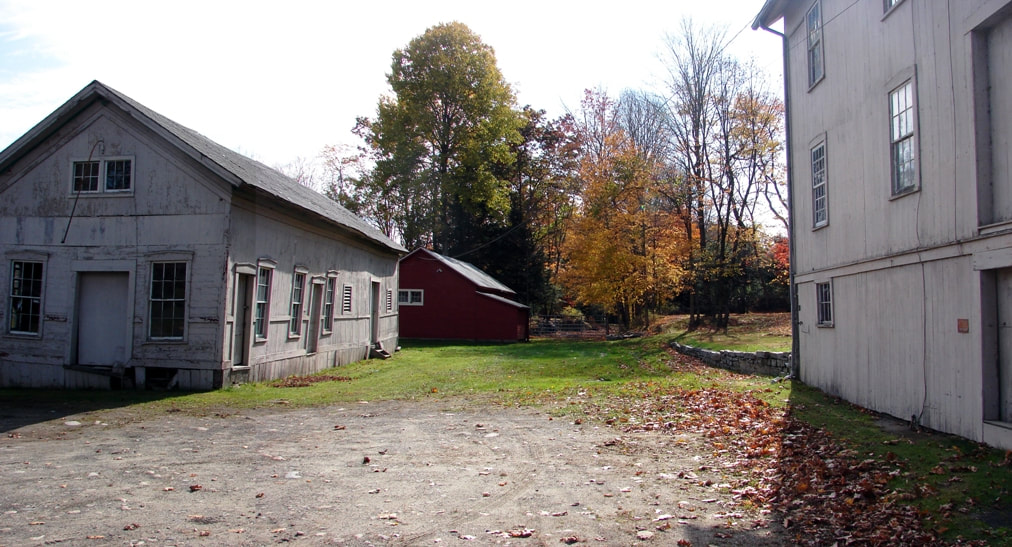
ROXBURY [SRR, 1872]
This stop in the town of the same name was established in 1872 when the Shepaug Valley RR opened. The railroad sold the station and the land on 6/7/1939 per Authorization For Expenditure [AFE] 32419. The dilapidated building was still in commercial use in 2010, as seen at [3], and was completely disassembled and rebuilt in 2018 as part of a distillery and wedding venue complex. A stunning reconstruction, the station restored to its 1872 beauty, as seen at [4], thanks to Elliott Davis, a local entrepreneur with an appreciation for historic structures. [REFS: CR/09/04/1875/02; DNT/06/24/2015/4A; WRA/10/09/2015/00; D157; R87][rev062815, 090319, 092119]
This stop in the town of the same name was established in 1872 when the Shepaug Valley RR opened. The railroad sold the station and the land on 6/7/1939 per Authorization For Expenditure [AFE] 32419. The dilapidated building was still in commercial use in 2010, as seen at [3], and was completely disassembled and rebuilt in 2018 as part of a distillery and wedding venue complex. A stunning reconstruction, the station restored to its 1872 beauty, as seen at [4], thanks to Elliott Davis, a local entrepreneur with an appreciation for historic structures. [REFS: CR/09/04/1875/02; DNT/06/24/2015/4A; WRA/10/09/2015/00; D157; R87][rev062815, 090319, 092119]
National Archives
|
Max Miller Collection
|
Litchfield Histoircal Society
|
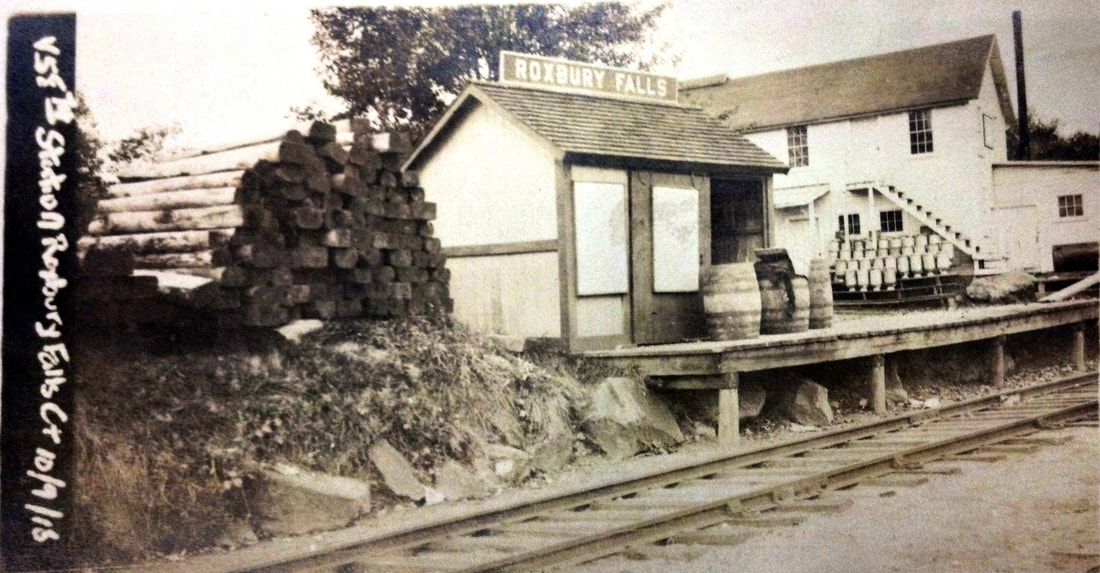
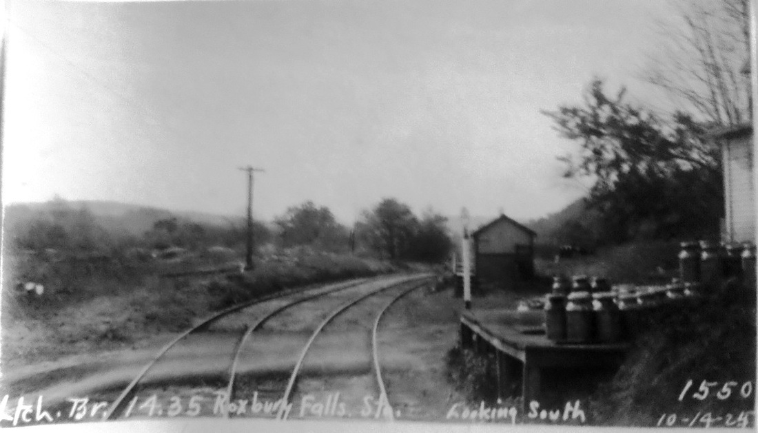
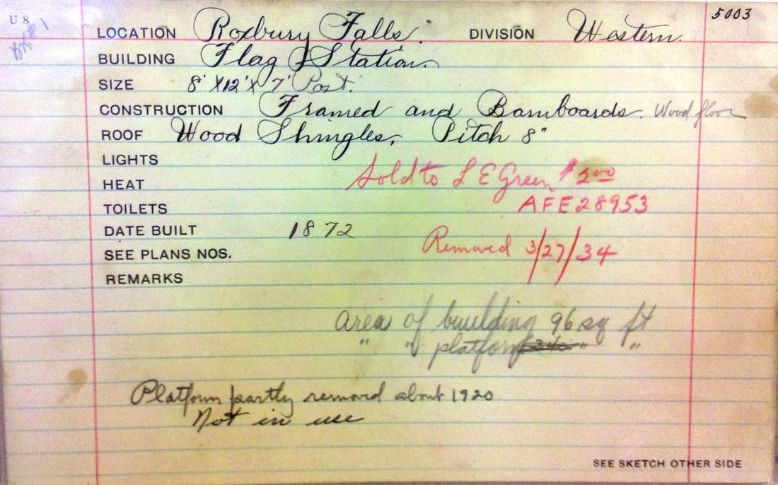
ROXBURY FALLS [SRR, 1872; depot, 1873]
Flag stop established in the town of Roxbury in 1872 when the Shepaug Valley RR opened; the 8x12x7 depot opened in August of the next year. The val photo at [1] is dated 10/9/1916. The PUC photo at [2] looks south at the station on 10/14/1924; note the cans on the milk platform in the right foreground. The real estate card at [3] shows the structure, #5003 on the NYNH&H books, was sold to L.E. Green for $2.00 on 3/27/1934 per AFE 28953 and it was removed on 3/27/1934. The card also says that the platform was partly removed ca. 1920 because it was no longer in use. The last passenger train ran in 1930 and the branch was given up completely in 1948. [REFS: HDC/08/08/1873/04: depot built; D157, K61][rev122718]
Flag stop established in the town of Roxbury in 1872 when the Shepaug Valley RR opened; the 8x12x7 depot opened in August of the next year. The val photo at [1] is dated 10/9/1916. The PUC photo at [2] looks south at the station on 10/14/1924; note the cans on the milk platform in the right foreground. The real estate card at [3] shows the structure, #5003 on the NYNH&H books, was sold to L.E. Green for $2.00 on 3/27/1934 per AFE 28953 and it was removed on 3/27/1934. The card also says that the platform was partly removed ca. 1920 because it was no longer in use. The last passenger train ran in 1930 and the branch was given up completely in 1948. [REFS: HDC/08/08/1873/04: depot built; D157, K61][rev122718]

|

|

|
RYE STREET [NYNH&H, 1898]
This stop was in the town of South Windsor. This shelter stood on the west side of the track as shown by the 1915 val map. This was not an original stop on the Connecticut Central but does appear by our rev7/18/1898TT. Its creation probably coincides with the takeover of the NY&NE by the NYNH&H. The 2/8/1932 is the last to show rail service here. By the 9/29/1935TT, the motor coach had taken over. In addition to the tobacco that the area is known for, the production of rye also goes back to Colonial times. It spawned several distilleries and, along with barley and corn, fed grist mills like the one on the Scantic River at Podunk that was established in 1750. [rev040113]
This stop was in the town of South Windsor. This shelter stood on the west side of the track as shown by the 1915 val map. This was not an original stop on the Connecticut Central but does appear by our rev7/18/1898TT. Its creation probably coincides with the takeover of the NY&NE by the NYNH&H. The 2/8/1932 is the last to show rail service here. By the 9/29/1935TT, the motor coach had taken over. In addition to the tobacco that the area is known for, the production of rye also goes back to Colonial times. It spawned several distilleries and, along with barley and corn, fed grist mills like the one on the Scantic River at Podunk that was established in 1750. [rev040113]