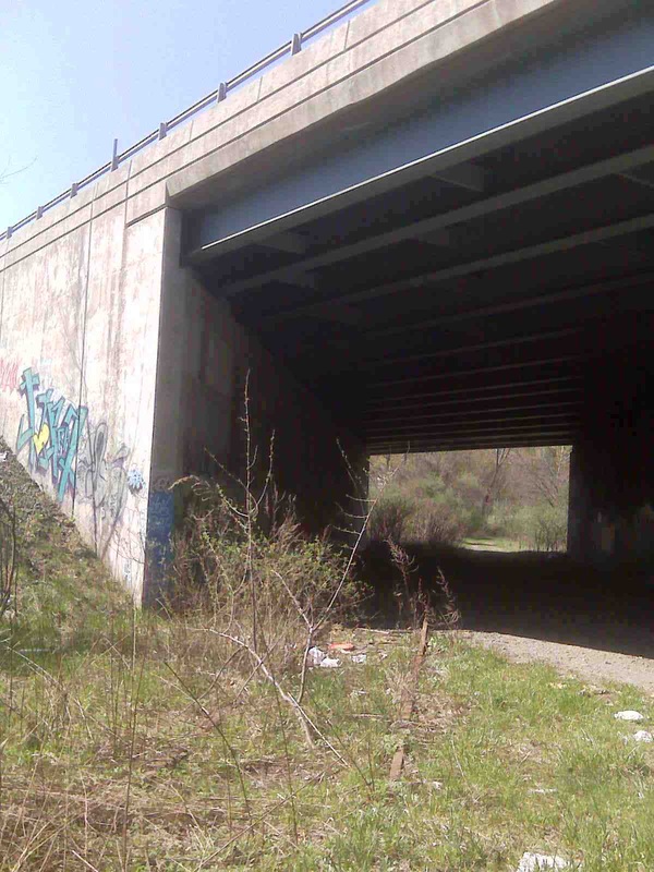
Track 4C - NH&D Main Line, Derby Jct. to Ansonia
Continuing your tour, Track 4C takes you through the great industrial area of the lower Naugatuck Valley from Derby Jct. to Ansonia!
|
|
|
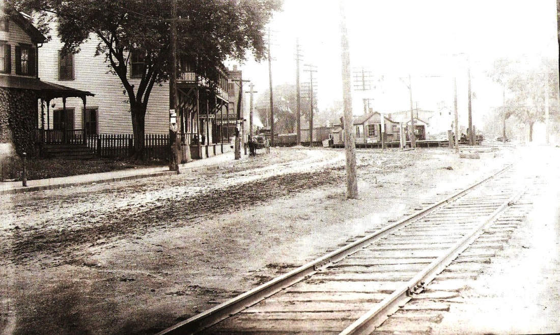
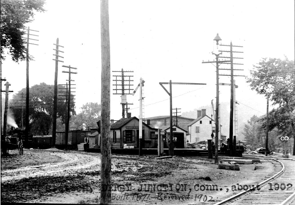
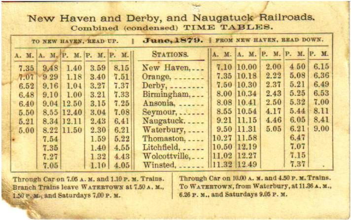
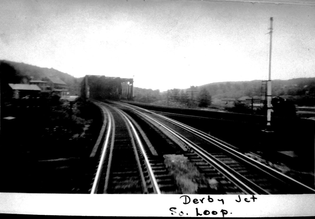
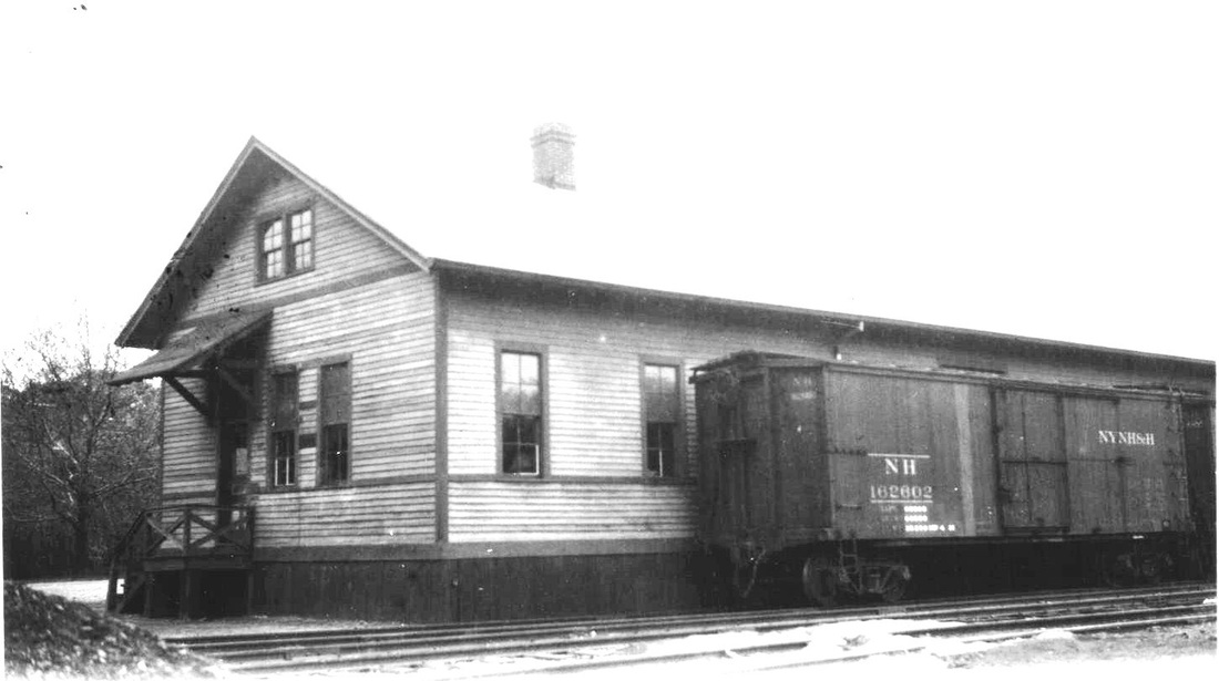
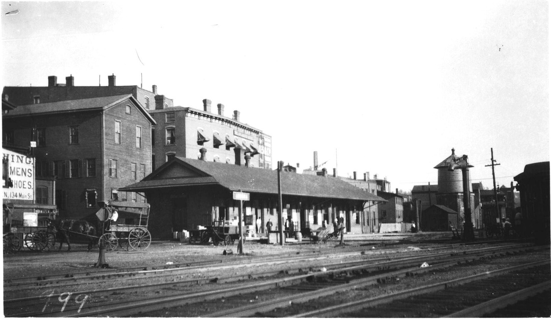
[4.57] The images at left and center look south toward Derby Jct., the latter being in 1902 and just prior to the removal of the depot. The 1871 build date, however, is not correct. This depot goes back to 1880 when a pooling agreement between the NRR and NH&D went into effect, at which time an interchange track was added as well as a 40x65-ft plank platform between the two railroads, and the "shanty" from 1871 was pushed "down the track some rods." The long-sought trade treaty caused the Derby Transcript to intone "Peace henceforth all along our borders" in January, 1880. The economic detente resulted in a 15% increase in NH&D receipts in the first month and cooperation thereafter resulted in the use of each other's tracks from Derby Jct. to Ansonia in times of need. In August of 1880, while the NH&D's trestle across the meadows was being refurbished and possibly the new covered bridge into Ansonia was being installed, the NH&D used the NRR track from Ansonia and passengers bought tickets and accessed NH&D trains at the NRR's (East) Derby station. While there was no accusation of collusion, both roads were chided in 1884 for charging the same 10-cent rate for the two-mile ride from Ansonia to either Birmingham or Derby, seen as excessive compared with two or three cents per mile charged by railroads elsewhere. The NRR dropped its fare to a nickel but the Derby, for the moment, did not follow suit. Rate complaints would be among the reasons for building the Ansonia, Derby & Birmingham RR in 1887. See below at MP 4.66.2. The covered waiting shed seen to the right of the station was added in 1886 to shelter passengers and baggage in bad weather. With the coming of the new NRR passenger and freight stations at Ansonia in early 1887, the newspaper also said that future transfers of cars would probably take place there and not at Derby Jct. There is evidence to suggest transfers took place at both locations over the years, with the June, 1879 timetable at right clearly showing through cars via Birmingham on the NH&D and handed over to the NRR at Ansonia for passengers travelling north. An 1882 article in the Register says that "in switching the rear car on to the Naugatuck track, the brake by some means got loose and followed in on the Derby track, striking the rear car with considerable force, breaking the bumpers and giving a general shake up to the passengers." The NH&D had complained on several occasions about these delays at Derby Jct. What these arrangements were for the exchange of freight and passengers here and how through cars were handled over the years is still not fully understood. [REFS: NHER/02/06/1879/04; NHER/03/07/1879/04; DTR/01/30/1880/03; DTR/02/06/1880/03; NHER/02/19/1880/04; DTR/02/20/1880/03; DTR/04/09/1880/02; NHER/08/21/1880/04; NHER/10/17/1882/04; NHER/03/27/1884/02,04; NHER/03/28/1884/01; NHER/11/17/1880/01; NHER/04/25/1884/02; NHER/11/30/1884/01; NHDP/01/25/1886 /03: new waiting room added; NHDP/04/03/1886/03; NHER/01/14/1887/02; NHWP/01/19/1887/04][rev011414]

Derby Historical Society
|

|
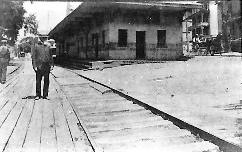
[4.57.1] The southward-looking shot at [1] is from the Images of America Derby book [p76] and at far left shows the actual Derby Jct. diamond; the NRR track is correctly labeled at lower right. Leman Stone built this warehouse ca. 1790 and it is seen here looking like it is on the verge of collapse, perhaps ca. 1900 since it is still seen on the 1898 bird's-eye map [MP 4.600, below]. The person sitting on one of the old freight bays may be waiting for a train since the depot is just out of sight to the left. The railroad, of course, contributed the ruination of the old warehouse structure. The woodcut at [2] is from the National Magazine of December, 1857 [p493] shows happier times with the other end of the building overhanging the Naugatuck River where it received freight from ships. An early NRR train heads south along the river bank. Stone was a well-known businesman and active in civic affairs. He was also the agent for the Paugussetts, the Native American tribe whose reservation was just south of here on Turkey Hill.
Archives & Special Collections, UConn
|
|
[4.58] Here are photos of the NRR's Derby station on the the east side of the Naugatuck River. The causeway bridge north of the station led to Birmingham, Derby's central and downtown borough until it was merged with the town to form the city of Derby in 1893. Shortly thereafter in 1896 and probably to reflect this, the railroad changed the name of the old NH&D station in Birmingham to Derby and the name of the NRR station seen here to East Derby. The man in the foreground in the photo at right is William Blakeman, a long-time resident and local merchant. The depot was torn down in 1904 to the relief of locals tired of what had become an eyesore. The team on Front St. belongs to W.M. Bradley. With the depot gone, the highway would be widened successively to what we know as New Haven Ave., Rte. 34, today. [REFS: HC/06/27/1896/11; AES/08/30/1904/06]
Jack Vagnini Collection
|
|
|
[4.58.1] This is not NH&D but a reminder of its competition on the east side of the Naugatuck River. The southbound train is heading for the Main St. crossing in East Derby. The snippet from our Track 12 Google Earth map shows current rail (blue), abandoned rail (red) and trolley (orange) at the busy East Derby junction point where streetcar lines intersected with the railroad. aOld-timers will remember the Howard Johnson restaurant that stood just south of where the train is, later Tailgators, and now River Rock, currently takeout only. [add110520]

[4.59] NHD&A #2, which, unlike the other four original engines, was never named for a railroad official, is reportedly posed here on the trestle crossing the Naugatuck River just above its confluence with the Housatonic, approximately where the railroad bridge is today from East Derby to Derby. The engine is most likely either at the northern end of Hog Island headed for Ansonia or at the southern tip of the Birmingham mainland and approaching the Howe truss bridge into Derby Jct. That point had been the intended terminus of the NH&D, which was planning just to interchange with the NRR here. Jeremiah H. Bartholomew, a business associate of Anson Green Phelps [see MP 4.63.3], was reportedly the one who pushed the very sensible idea of the NH&D going to Birmingham and Ansonia to serve and profit from the many factories and businesses in those places [HOTD: 25-27]. Bartholomew would go on to be an NH&D director as well as its third president.
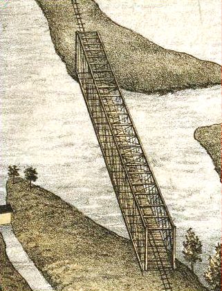
[4.59.01] This is from the Bailey 1875 bird's-eye map of Ansonia. See below at MP 4.65. This is the original bridge, a wooden truss structure, at the NH&D's upper crossing of the Naugatuck River into Ansonia. The bridge here at Derby Jct. was presumably similar. Upgraded bridges at both places installed in 1880 were also wooden structures but covered for protection from the elements [CRC26.1879.25; CRC28.1881.15]. The contract for a new iron bridge at Derby Jct. was awarded to Murray, Dougal and Co. of Milton, PA, with a price tag of $5,065 [NHER/05/09/1879/04; NHDP/05/10/1879/04; NHER/05/12/1879/04] but the builder reneged owing to a steep rise in the cost of iron [NHDP/04/26/1880/04]. The 205-ft bridge here was constructed instead by A.D. Briggs & Co. of Springfield at a cost of about $4,300 [NHJC/11/10/1879/02; NHER/11/17/1879/01]. A temporary trestle was put up so trains could bypass the work on this new bridge, which was finished mid-April, 1880 [DTR/02/20/1880/03; DTR/04/16/1880/03]. Briggs likely also put up the new one at Ansonia. It is not known whether there were any iron components at all in these bridges but wood and iron bridges did exist. Murray, Dougal was known more for building railroad cars than bridges and became one of the companies that merged in 1899 to form American Car and Foundry [click here].
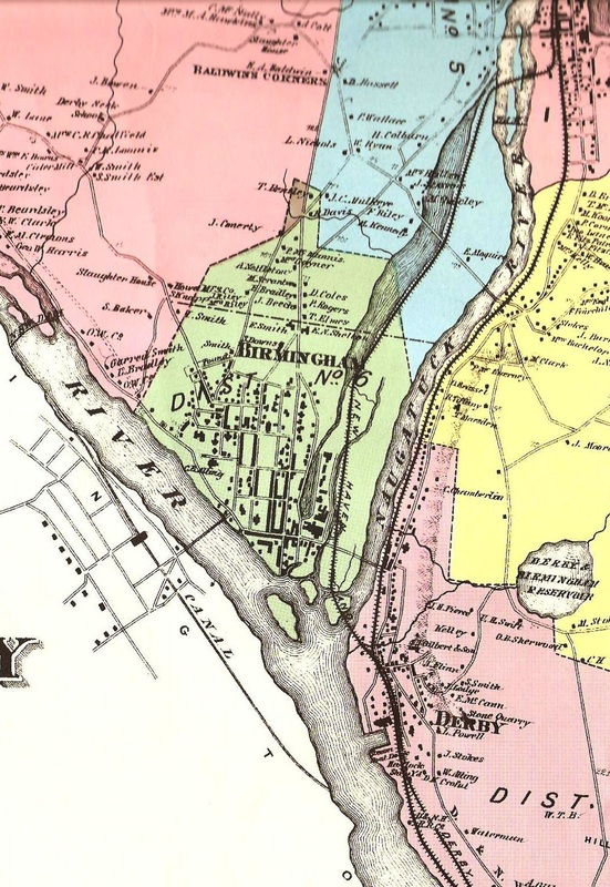
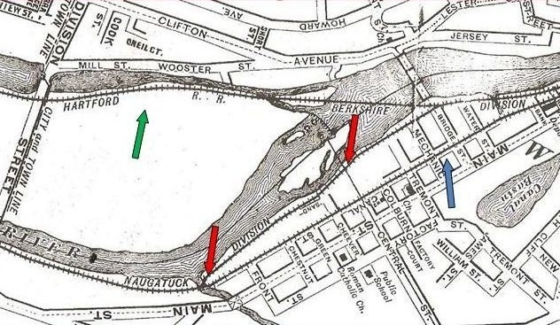
[4.59.1] This is a close-up of the Derby map from the 1868 Beers atlas of New Haven County and has to be used with caution. While it shows NH&D complete all the way to Ansonia, the portion from Derby Jct., only added to the plans in 1868, is the projected route. The right-angled crossing of the river into Ansonia is not the diagonal crossing that was actually built. The Shelton canal and Ousatonic Dam (extreme left), both of which only opened in 1870, are also seen. The NRR, operational for some 20 years already, is shown with the safer route it chose on the east side of the Naugatuck River. The NH&D route here would be largely on trestle at the start through the flood plain, called 'the flats' or 'the meadows.' In this low-lying area, nevertheless, there were once several residences now reduced to one house seen on the map above on Old Town Rd., a trotting park [NHER/01/23/1891/01], and a cave where 'brigands' hid out until an NH&D engineer reported them [NHER/11/30/1884/01; 12/01/1884/04]. This was a precarious balancing act for a fledgling railroad that was determined to serve Birmingham and Ansonia through the repeated floods that the river has always been noted for. Also seen are the extensive waters of the Birmingham canal, west of the river and wider than it at some points, that went right down into the center of the borough to power the industries there. The Birmingham Water Co. dam that diverted flow into the canal can be seen as the line across the river below the NH&D crossing on this and other maps. The lower channel into the canal is not seen here but is shown on the map at MP 4.71.1 below.

|
Connecticut Historical Society
|
[4.60] The image at left is from the 1898 Landis and Hughes bird's-eye map [click here]. The 1880 NH&D depot is in the lower left and the NRR's 1848 Derby depot is at the lower right. The 1880 covered bridge is also seen. The Extension now diverges west on Hog Island. Note also the curved riverfront trestle that was put in to serve the Alling, aka Paugassett, Mills and the Bassett Co. When the Extension was being laid out, these important Birmingham apparel-makers wanted it to be on their side of the Housatonic to better serve them and not make Shelton more competitive. While some Sheltonites resisted the railroad for other reasons [see Track 5, MP 5.5], the spur was enough to make the mill owners drop their opposition [NHER/07/18/1888/01; RRC23.108 (5/18/1889)]. The view is largely replicated in the CHS photograph to the right.
Connecticut Historical Society
|
|
|
|
Jack Vagnini Collection
|
Jack Vagnini Collection
|
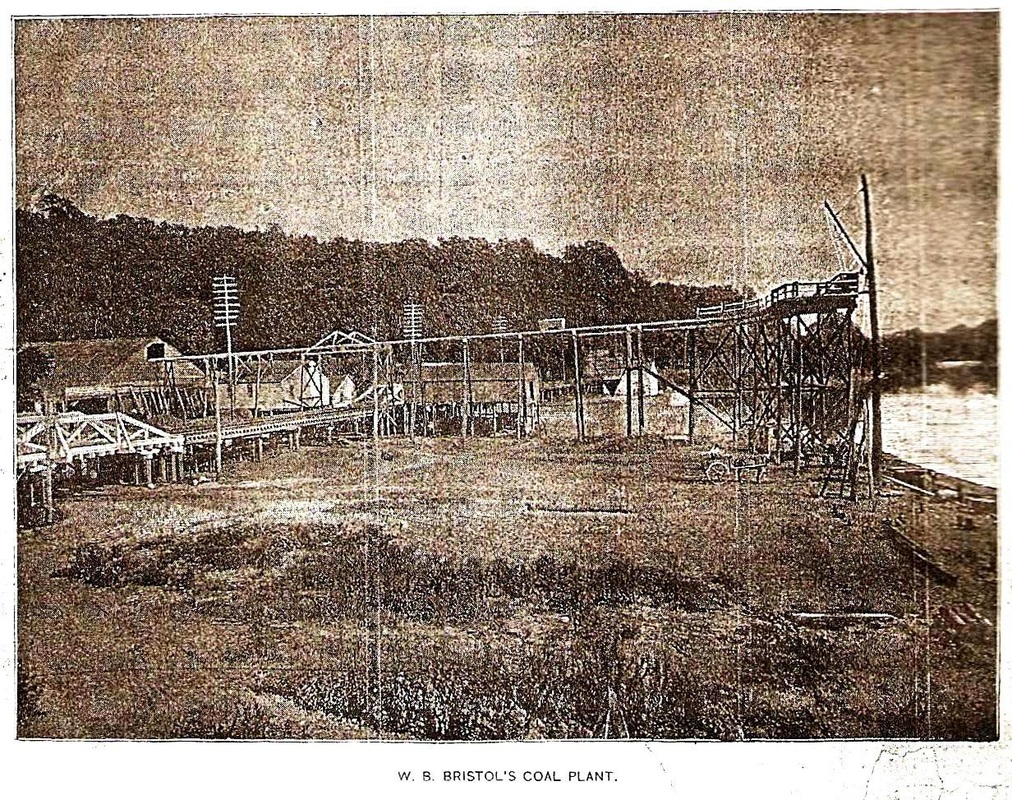
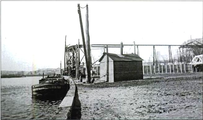
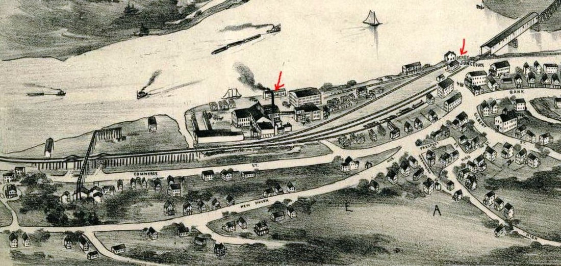
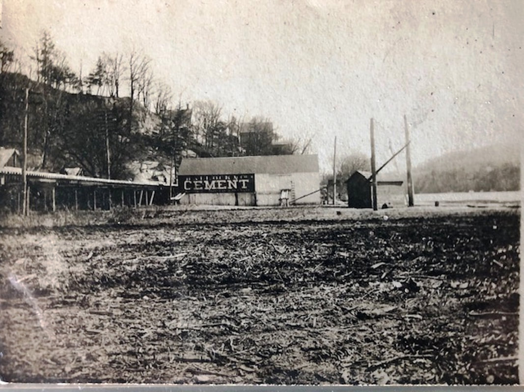
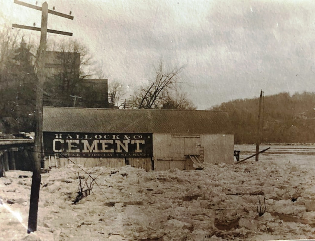
[4.60.1] The image from CHS at [1] shows the southern end of East Derby and its small commercial enclave by the river. The photograph probably dates to the 1890s, based on the box car that we think says HRR. That road would be leased by the NYNH&H in 1892 and its rolling stock re-lettered for the new owner sometime thereafter. We were never really sure of the orientation of this photo until we matched the tall smokestack of the Derby Lumber Co. with the image on the 1898 bird's-eye map at [4]. The photo looks south, the track all the way to the right is the NRR and the ones in the foreground are the NH&D. They cross at Derby Jct. to the far right, just before the bridge. In the far left one can see the coal transfer that passed over the tracks of both railroad companies, themselves on trestle in this marshy area. The image at [2] comes from the Illustrated Review of the Naugatuck Valley [p26] and is a wonderful corroboration of the bird's-eye map, showing W.B. Bristol's coal plant in better detail with its "automatic railway, built in 1886" running overhead. The photo [3] shows a northward view of the plant. The images at [5] and [6] show the iconic Hallock & Co. cement operation. Steamboats and barges had tied up since the 1840s at the Derby docks landing and pioneering electric freight service service was briefly provided from here to Birmingham and Ansonia: see below at MP 4.66.2. The trolley track was later cut back to the causeway bridge that can be seen on the full 1898 map. [rev110520]
|
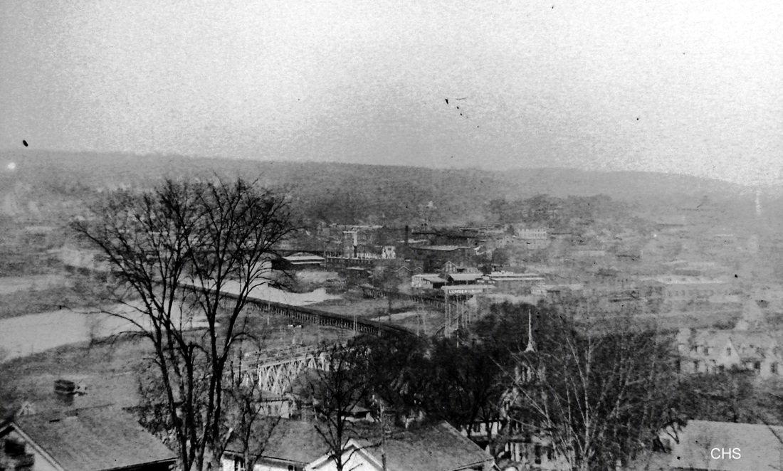

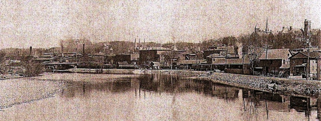
[4.60.2] This panoramic CHS photo puts a somewhat different perspective on Derby Jct. The shot was apparently taken from atop High St. in East Derby. In the bottom at river level, the Derby Jct. triple bridge is seen through the trees. In the center, the Extension, now the double-tracked Maybrook line, heads west across the Housatonic River. To the right, one sees the Birmingham spur along the river's east bank. The 'lumber' sign is prominent and the advertising card image to the right shows it belongs to the United Lumber & Supply Co. that was apparently the predecessor of the later Housatonic Lumber. In the distance on the card, a train on the Extension crosses into Shelton.
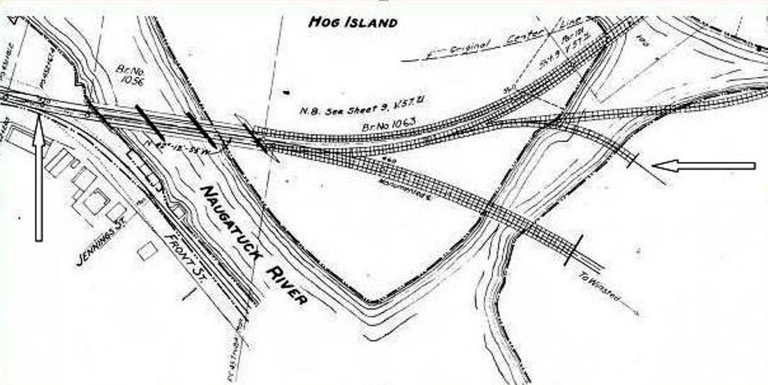
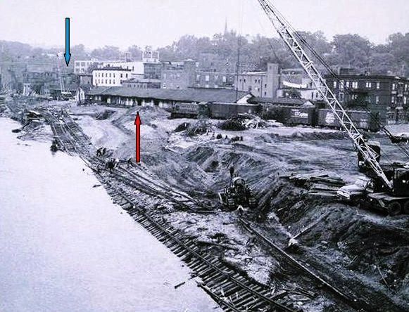
[4.61] This is a snippet from the 1915 valuation map showing Derby Jct. The track at the left arrow is the old NRR mainline, which was left in place for secondary service. The dangerous Main St., East Derby grade crossing there was one of the reasons for rerouting the line to the other side of the Naugatuck River in 1903. The opening of the new Derby station at that time also enabled the East Derby station to be torn down in 1904. The triple-tracked, three-span railroad bridge across the Naugatuck River was finished in 1904 [CRC53.1905.26]. This composite structure, which was built as three side-by-side bridges on piers that spanned the entire triple width, replaced the old 1880 covered bridge. Iron for the new bridges reportedly arrived in December, 1903 and work was expected to be completed by February [AES/12/09/1903/09]. By August of 1904, the out-of-service covered bridge was gone [AES/08/05/1904/07]. Some of the NH&D main is still in place on the map at the arrow on the right with access to the Derby riverfront siding reconfigured to come off it from the south instead of the reverse loop from the north as before. The mammoth double-tracking and relocation project required numerous property transfers from here to Ansonia between the NYNH&H and its leased NRR and NH&D roads as the latter were still legal entities at the time. These transfers can be traced in the New Haven and Derby Index Map volume at NHM. Derby Jct., thus expanded and modernized, would be further increased in importance when car-weighing scales were put here in 1906 [AES/05/11/1906/12].
J.J. Harness, Copyright NHRHTA
|
Copyright NHRHTA
|
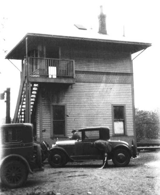
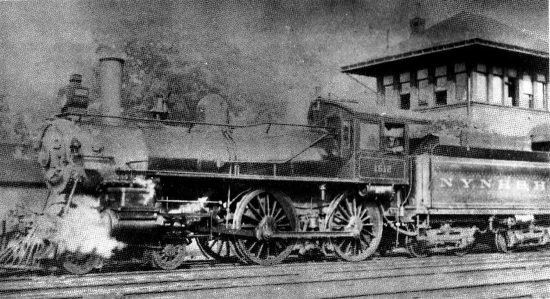
[4.61.1] At left, SS B-253, Derby Jct. tower, in a valuation photo taken by J.J. Harness on May 13, 1931. The tracks are immediately behind the tower and the triple bridges across the Naugatuck River are a little farther to the right. Engine #1612 is shown in front of tower in the photo at right.
Copyright NHRHTA
|
Copyright NHRHTA
|
Copyright NHRHTA
|
|
TCS Collection
|
Copyright NHRHTA
|
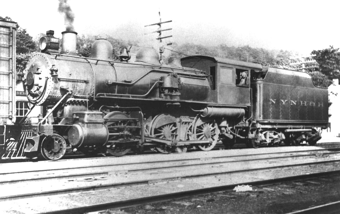
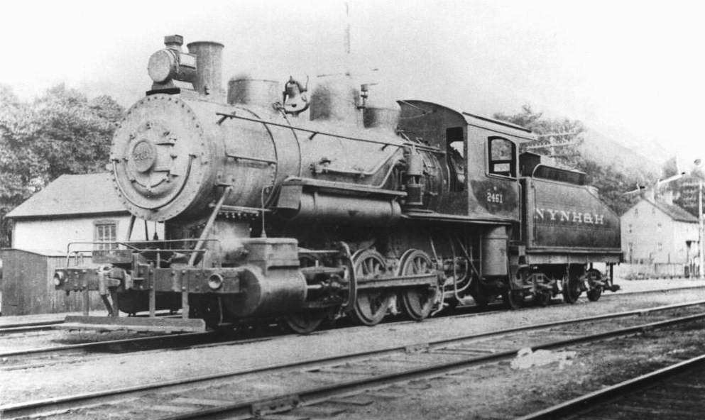
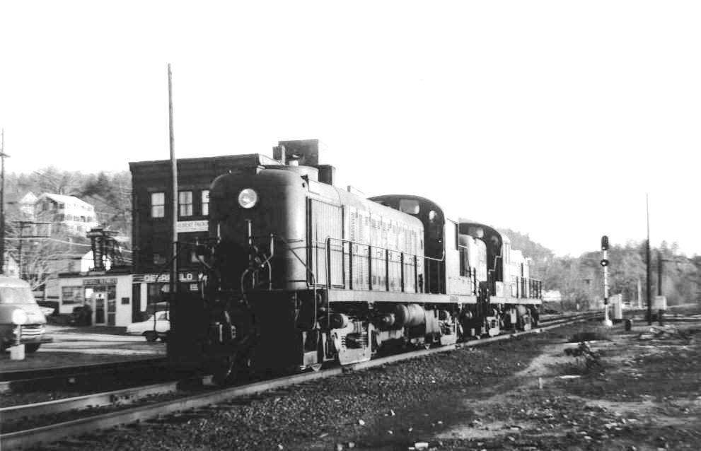
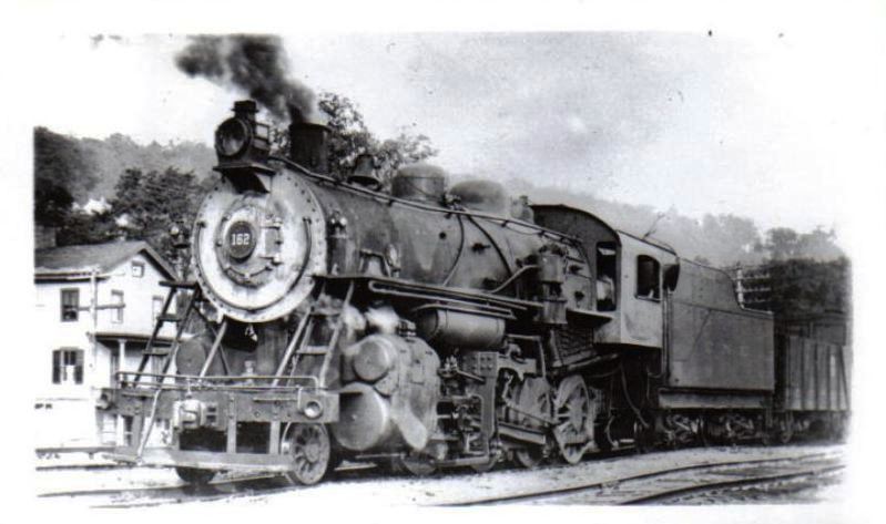
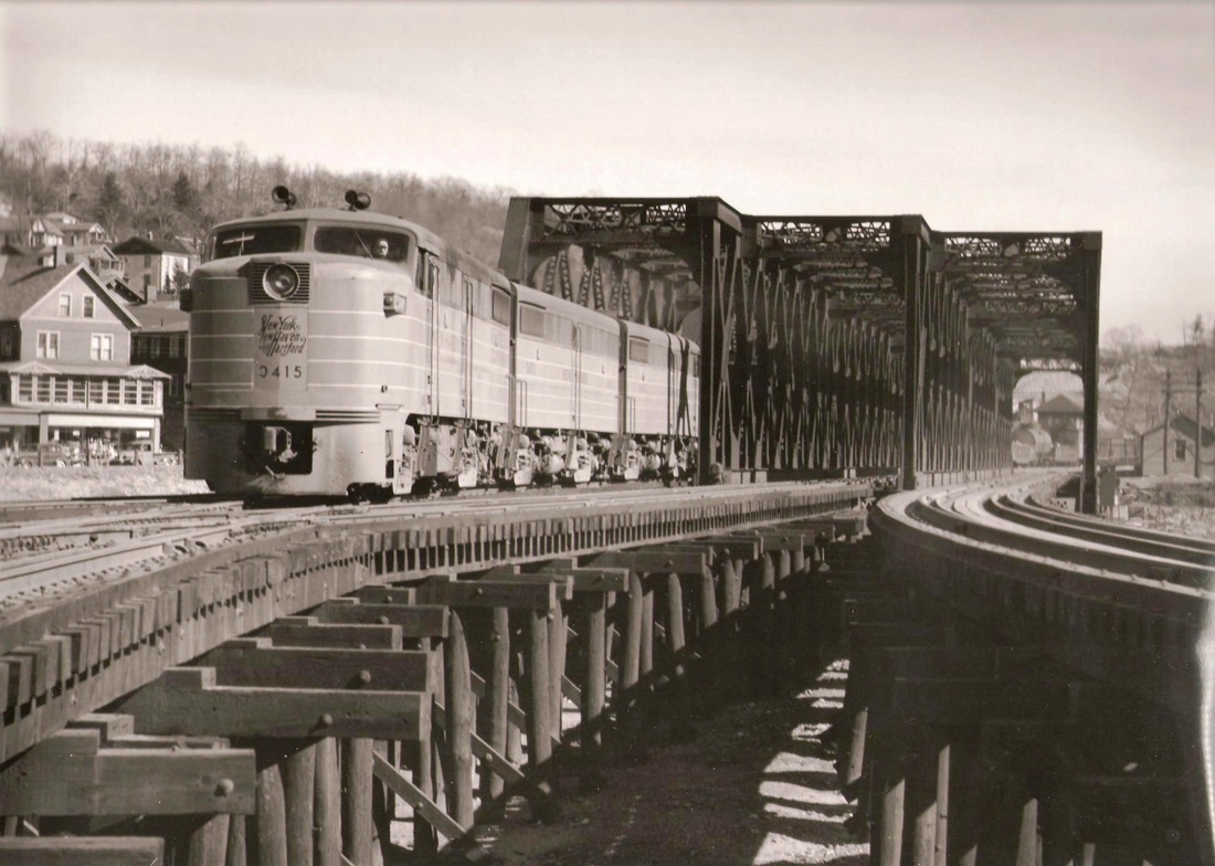
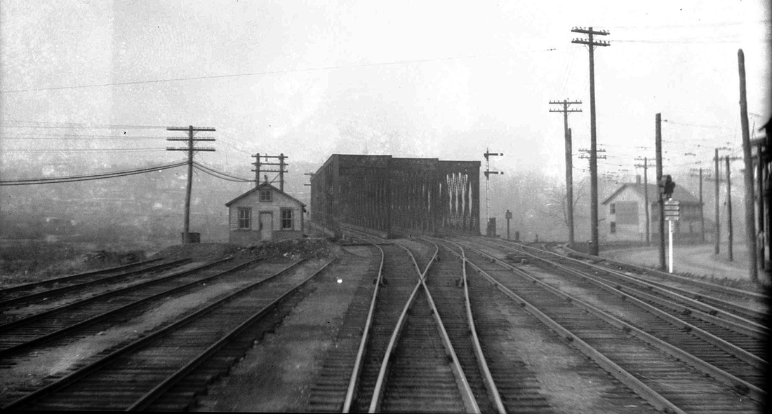
[4.61.2] A Derby Jct. quintet! The image at [1] is NYNH&H #496, a Schenectady K-1-a, built in 1896, with 20x28-inch cylinders and 63-inch drivers, formerly NYNH&H #427. The Derby Jct. tower sign can be seen in front of the engine's smokebox. The photo at [2] is #2461, a T-2-b Alco built at the Richmond Works in April of 1913 with 19x26-inch cylinders and 51-inch drivers. The shot at [3] of the DERS engines was taken by Don Woodworth on December 18, 1964. The nearer engine is DERS-2c #560. The image at [4] is CNE #162. The photo at [5] is thought to be in the late 1940s with FA #0415 on the point leading a train up the Naugatuck line. That easternmost bridge would be removed in 1955 after being damaged by the hurricanes of that year. Here all three look well maintained as does the causeway trestle both to Derby on the left and to Shelton on the right. The view at [6] shows the south end of the triple bridge, with the old NRR track still connected and cutting off to the right. At left are stub-ended tracks which met the old covered bridge. We have yet to determine what that the building at the river's edge is.
New Haven Register
|
Archives & Spec Colls, UConn Libraries
|
Archives & Spec Colls, UConn Libraries
|
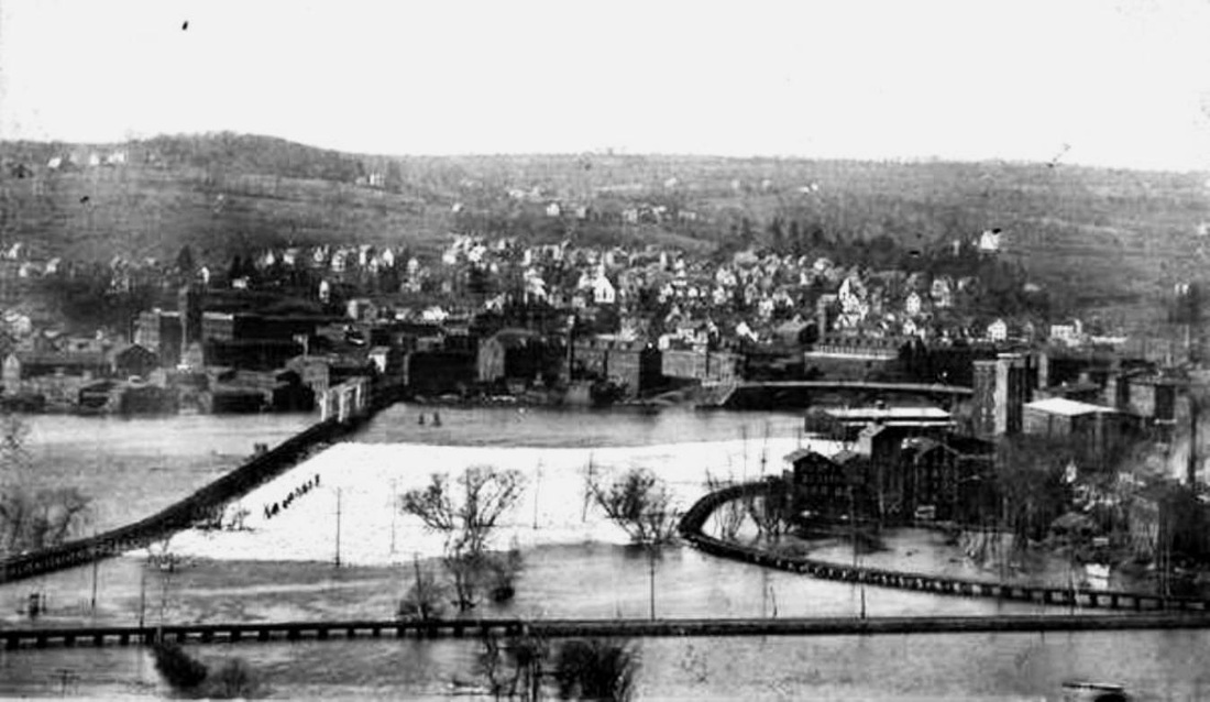
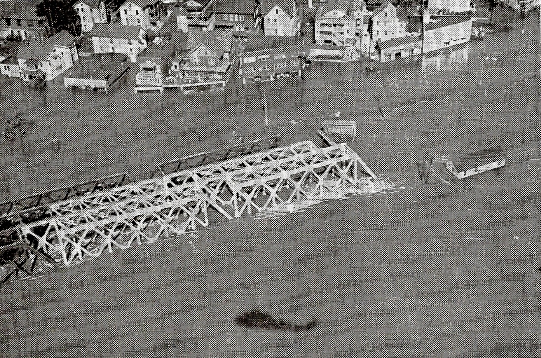
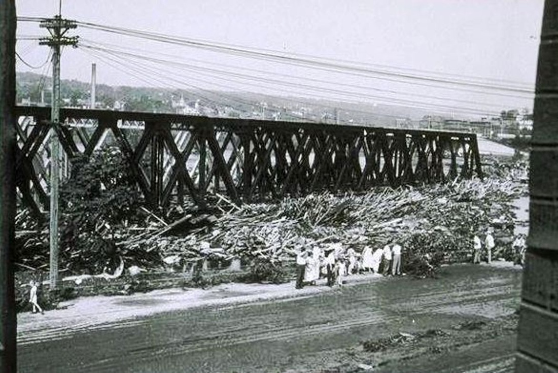
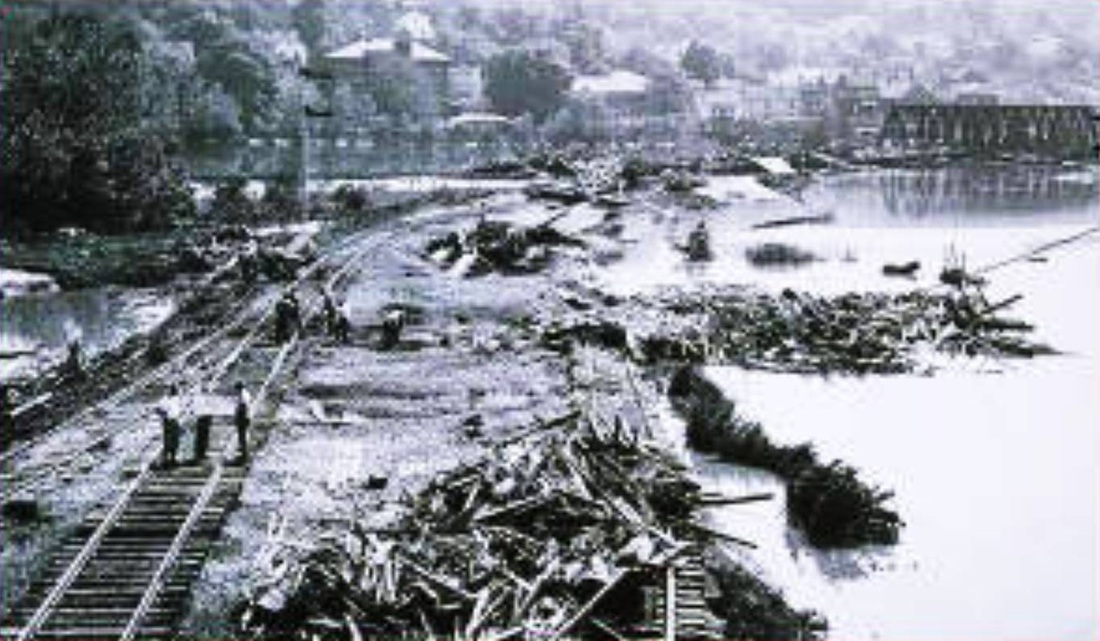
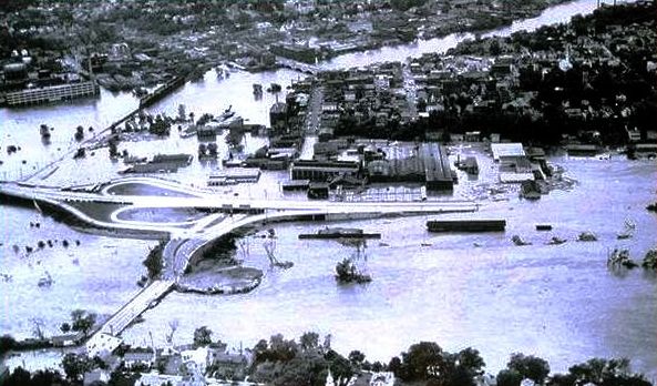
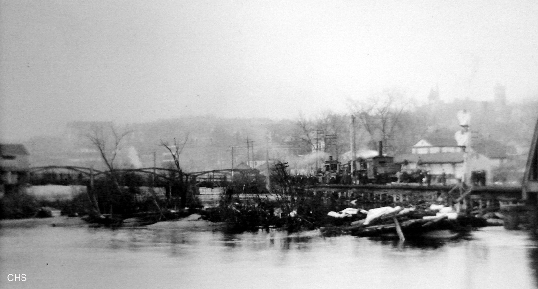
[4.61.3] Here are three views of Derby Jct. after the flooding of August, 1955. The second and third shots are Charles Gunn photos. The left image still shows the three bridges. The picture ran in the Register five years to the day after the flood [NHER/08/19/1960/22]. Note the reflection in the water of the helicopter overhead. This may be the Marines "whirly-bird" that is taking NHRR Pres. McGinnis for another look at the damage on August 24 after the copter mistakenly landed on the New Haven Green looking for him the day before [NHER/08/23/1955/03]. The right shot is along Rte. 34 in East Derby. The bridge closest to the photographer in the middle shot was taken down after this because of the weakening of one of the piers. It almost looks like some of the upper cross pieces are missing or buckled on this span in the first shot. The white color of some parts of the bridges is unexplained unless it was some kind of preservative being applied when the floods hit. There is an informative thread covering the tracks and bridges here at the NHRHTA Forum [click here]. Also, there is an interesting shot of Derby Jct., which appears to show the east bridge out later in 1955. Click here and scroll down to the three Ansonia pictures, the first and third of which are mislabeled, being the Derby freight house and Derby Jct. respectively. In the latter, the lack of the outer diagonal on the northeast end seems to corroborate the removal of the eastern span. The crane sitting in the water probably was involved in the work and caught by the October 14 surprise second flood, which set back the railroad's recovery efforts considerably. After this, Derby Jct. would have only two bridges with a track each for the Naugatuck and the Berkshire lines. Our 1956 timetable map shows double-tracking still in place to Ansonia. North of there it was reportedly removed in January, 1950. The lower photograph here looks toward Derby Jct. still with three bridges, so this is clearly between the first and second floods. The split for the Extension is in the upper middle, with the second Berkshire line track washed away and to be replaced shortly. The workers are standing by the switch for the old Alling Mills siding into Derby.

TylerCityStation Collection
|

TylerCityStation Collection
|

TylerCityStation Collection
|
[4.61.4] Derby Jct. ca. December 1980, with two shots of the bridge looking across the Naugatuck River toward downtown Derby.
TylerCityStation Collection
|
TylerCityStation Collection
|
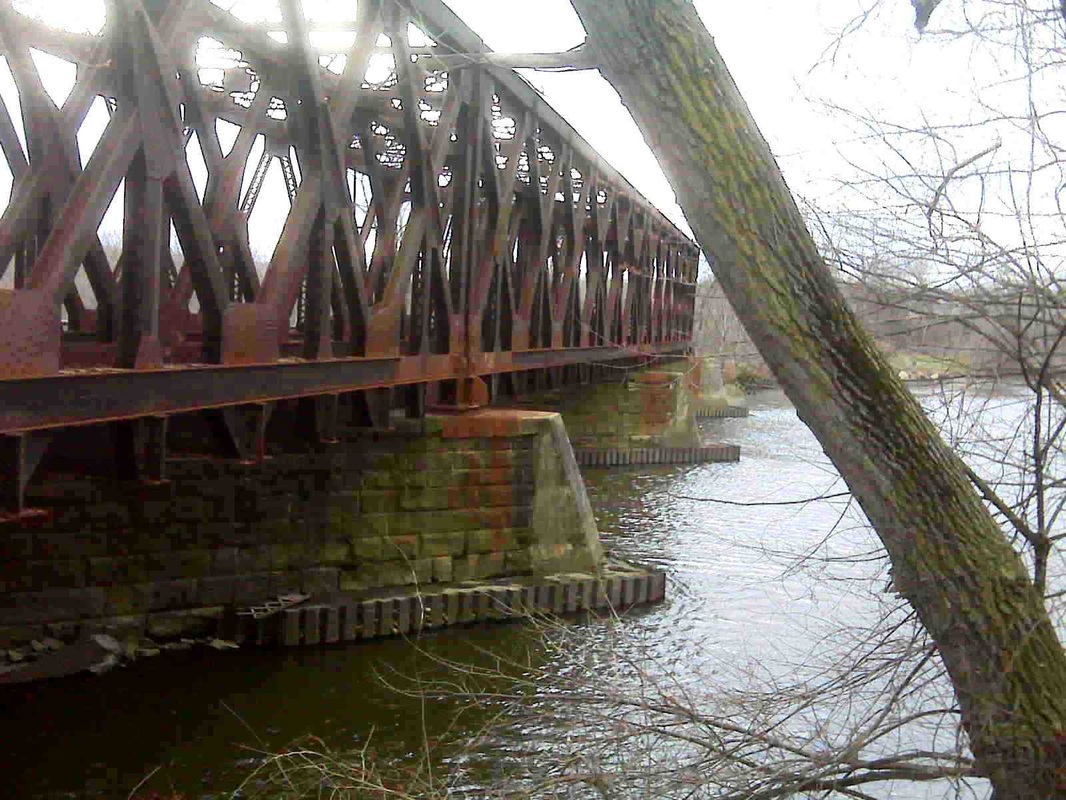
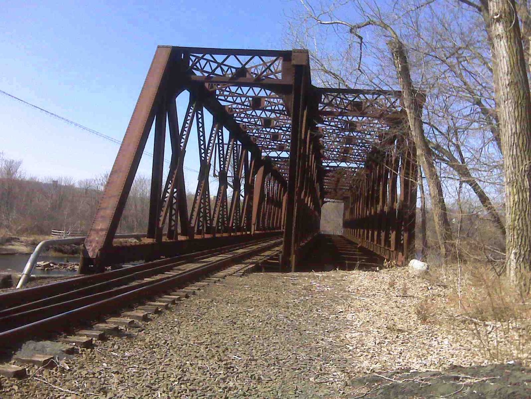
[4.61.5] Two views on March 21, 2009. The shot at left shows the piers with concrete end-caps. This was done when the eastern span was removed after taking most of the battering by water, lumber, and other 1955 flood debris, with the masonry cut back to support just the two remaining bridges. Exactly when this work was completed is unclear. The newspapers said the Maybrook track, the one seen here on the western span, was back in freight operation on August 25 [HC/08/26/1955/10; ES/08/25/1955/09]. As pictured in the newspaper, what looks like a full-size construction crane was hoisted up to the top of the bridge for quicker clearing of the track [ES/08/26/1955/??]. Restored access to the Naugatuck line was not expected until the early part of 1956 [ES/12/01/1955/06]. The shot at right shows the two surviving bridges. The track on the former middle span was reportedly removed in 1964 when the deteriorated wooden trestle work on the north end was replaced with a single track that splits there for the former Naugatuck and Berkshire lines. [rev092420]

TylerCityStation Collection
|

TylerCityStation Collection
|
[4.61.6] Two shots looking back at the bridge to Derby Jct. in December 1980, including the Waterbury train of that era heading for the Derby station.
Dave Peters Collection
|
Dave Peters Collection
|

George E. Votava photo
|

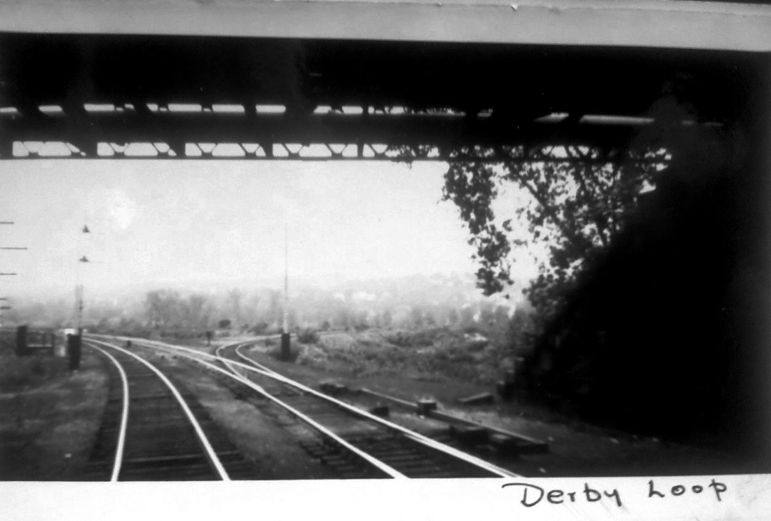
[4.61.7] The first two shots look back at the area called the Derby Loop, with the wye track to the right going toward Shelton and Maybrook that allowed trains to avoid the heavy NY&NE grades between Hawleyville and Hartford. The loop track was put into service on 7/11/1917: "This morning's freight traffic over the "Y" which connects the Berkshire tracks with the Naugatuck division was very heavy and observers are now convinced that the company has substituted the Derby route for the Hawleyville route for freight from Poughkeepsie Bridge destined for points east. Four heavy freights passed through in quick succession this morning. For some time past freight has been accumulating at the company's large yards at Maybrook, N.Y., and since the Berkshire and Naugatuck lines have been connected between Derby junction and the Derby station the company has been sending all the trains that it's available engines and crews will permit." The photo at lower left shows the Besler steam train approaching Derby station on 11/11/1936. This is train 456 operating from Bridgeport to Waterbury, according to information on the back of the photo. The post card at lower right shows the train heading back to Bridgeport. The two-unit, air-conditioned streamliner was 163 feet long and had seats for 152 passengers. It first ran test runs from New Haven to Bridgeport, then up to Waterbury and Hartford and back to the Elm City on 8/19/1936. [REFS: HC/07/14/1917/08, quoting AES/07/11/1917/00; HC/08/19/1936/03; B16]

TylerCityStation Collection
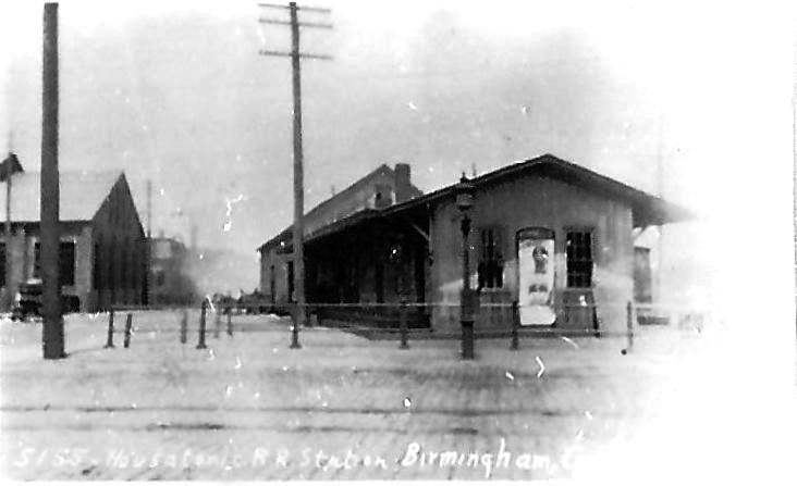
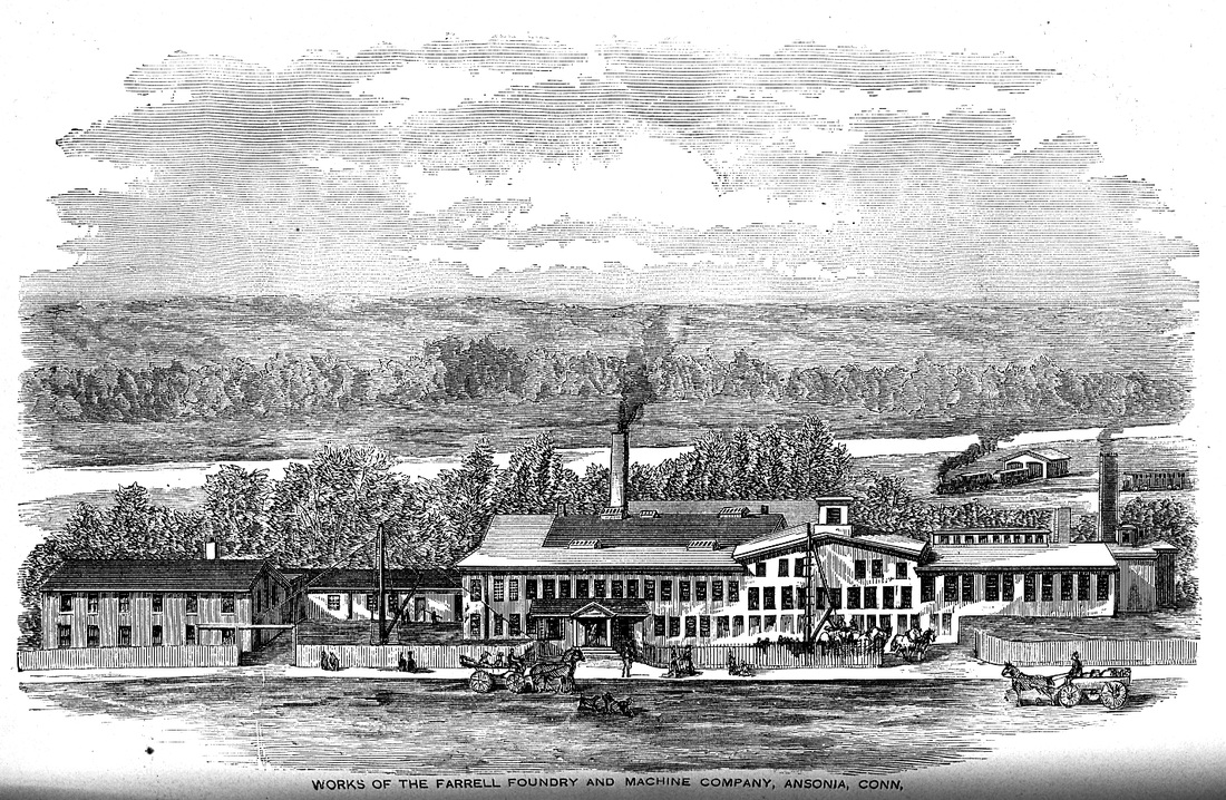
[4.62] Birmingham Iron Foundry (BIF), which began operations in 1836 as Birmingham Iron and Steel Works, was one of the large manufacturing concerns to which the Derby road brought direct railroad service. Prior to that, raw materials and finished goods had to be carted over the Naugatuck River to and from the NRR's (East) Derby station. In this advertisement, our New Haven-bound NH&D train is pulling into the Birmingham station, which is just ahead on its left and across the street from the factory complex. BIF merged with the Farrel Foundry & Machine Co., established in 1848, to become Farrel-Birmingham Industries in 1927, rearranging the initialism from BIF to FBI. The Farrel Corporation is still headquartered in Ansonia today.
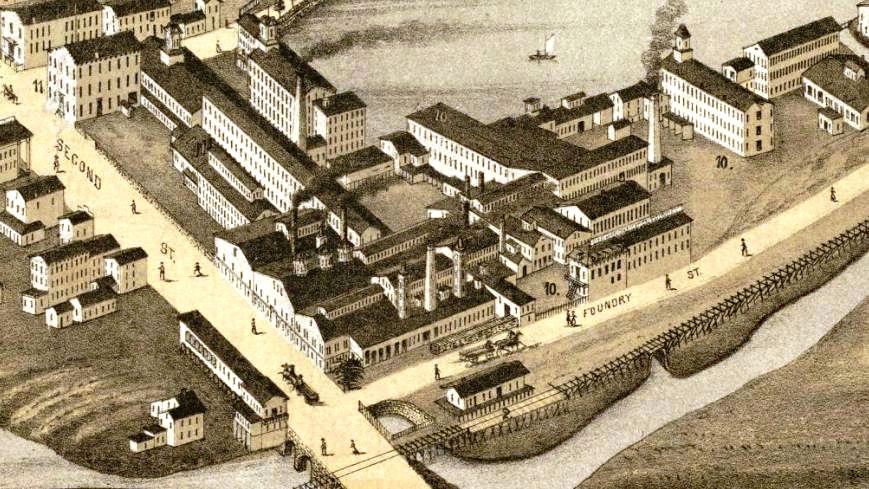
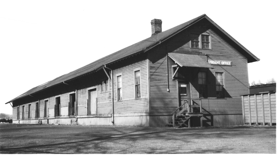
[4.63] Based on Oakley Hoopes Bailey's celebrated reliability, this sketch of the Birmingham station is probably quite accurate. Click here for the full 1876 map. This station stood west of the track at the northeast corner of Foundry and Second Streets, the latter of which would later become Main St. Notice how the ornate office building above 'Foundry' in this shot matches the one in the advertisement just above. Rockey [2:377] says the Birmingham station opened in March of 1872, but the Journal says it was nearing completion in December of 1871 [NHJC/12/15/1871/02]. It was largely paid for and "owned principally" by William E. Downes, who would be on the NH&D board of directors from 1882 to 1889. The importance of this stop to local industry is seen in reports like the one that said a thousand tons of scrap metal was unloaded here for use at BIF late in 1879 [NHER/12/16/1879/01]. The original combination station was "practically ruined" in a serious fire, arson suspected, on 06/30/1879. [NHER/06/30/1879/04; NHDP/07/01/1879/04; NHER/08/01/1879 /04]. The cost of the new depot was reported [CRC26.1879.186] to be $4544.01. In 1884, the platform was relaid with chestnut planking [NHER/06/02/1884/04].
TylerCityStation Collection
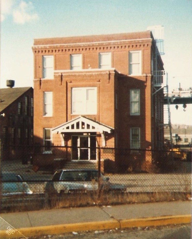
[4.63.0] This venerable structure was once part of the BIF complex. It stood here for years, readily visible from Rte. 8. and near what used to be the corner of Foundry St. It was set back from today's Main St. and west of the railroad station. Note the hoisting apparatus in the air to the right of the building, still seen ca. 1980, as testimony to the heavy 'lifting' that was done here.
|
|
[4.63.1] The photo on the left is a rare view of the old NH&D Birmingham station. It corresponds to the 1898 map on the right showing the depot facilities as they appeared in that year at Birmingham, which had become the city of Derby in 1893. Newspaper reports in 1877 say that the NH&D station has been moved "eighty feet and now fronts on the main street," as it does in the photo, and also that it has been "enlarged and made into a passenger and freight depot both" [NHJC/04/09/1877/02]. Moving the passenger station also served to cover the canal race, "the unsightly and dangerous opening that is now conspicuous there" [NHJC/03/03/1877/02]. This part of the structure appears to be what is above the red arrow at MP 4.63.3.
Plumb Library
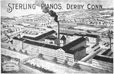
[4.63.2] This poster appeared in the 1896 Souvenir History of Derby and Shelton, Connecticut, published by the local Evening Transcript newspaper. The Sterling Co. was located on Foundry St. north of BIF and was another of Birmingham's major employers. The mammoth complex of white buildings seen here is more distinguishable on color reproductions. Trains are seen on the poster, one southbound on the NH&D line west of the Naugatuck River and one northbound on the NRR east of the river in the distance. The water flowing in the foreground is the Birmingham Canal.

DiRienzo Collection
[4.63.3] This shot of the new Derby depot was most likely taken from high above East Derby on Derby Hill. It appears to be within a week of when the station opened on Sunday, 10/18/1903, also the day when the 9:35 a.m. train to New Haven was the last to use the old NH&D depot [AES/10/15/1903/06; AES/10/17/1903/06; AES/10/19/1903/07]. The first train to use the new right of way and this station on opening day was the 12:27 train from New Haven pulled by engine #201. On board was 35-year veteran Conductor Edward B. Bradley who had been in charge of the first NH&D train in 1871 and would retire from the railroad in 1906 [AES/02/07/1930/03]. One 1899 article said this was to be a 'union station' for Derby and Ansonia but new structures were built at both locations in 1903 [HC/11/16/1899/03; NHAR 32.1903.7]; what was probably meant was that the NRR's East Derby station would be eliminated, which did happen in 1904. The tearing out of the NH&D track began immediately. The work, which looks to be in progress here, was necessary to complete the driveway and grounds for the new depot as well as to reinstall the Derby Street Rwy tracks on the newly built Main St. viaduct that is seen at extreme lower left. The building at the arrow seems to correspond to the newer freight wing, shown above on the 1898 map. The newspaper said it was being torn down on 10/26, while the 1880 station building had been razed on 10/21 [AES/10/21/1903/09; AES/10/27/1903/06]. This may date the photo above to the five days in between. The newer freight depot, seen to the right, opened on 10/19. BIF is seen here on Foundry St. in the center and to the extreme right you can see the white building which marks the start of the Sterling Co. complex. The realignment of the railroad 300 feet eastward was to facilitate the new route of the Naugatuck Division, here following the old NH&D line from Derby Jct. to Ansonia. The double-tracking was mostly complete by this time from Naugatuck Jct. to the border with Ansonia, which had evolved from a borough within Derby to an independent town by 1889, a city by 1893. The dividing line was at Old Town Rd., then appropriately renamed Division St. as it is still known today.
Archives & Special Collections, UConn
[4.63.4] A view of the new Derby depot looking to the east. A serious fire on December 17, 1913 did significant damage to the building and burned off the entire roof. It cost a good part again of the original $15,000 station expenditure to repair the structure, after what was thought to be a gas line explosion and fire [AES/12/17/1913/13; AES/12/18/1913/08]. The fear was that in its "present crippled financial condition" the railroad might leave it as a "leanto" but the NYNH&H was reportedly rising to the occasion to restore the station to its former condition. Ironically, perhaps, less than a year after this station opened, the number of passengers taking the train to New Haven was reportedly down 75%, this after the opening of the Connecticut Railway and Lighting Co. trolley line on 12/12/1903, which was doing a booming business [AES/12/12/1903/07; AES/07/28/1904/07]. Of course, the Consolidated was well on its way to taking over the trolleys, but for a time the competition was adding to its fiscal difficulties. The local press also lamented that the railroad had failed to install fire hydrants on the property, especially short-sighted in light of the fact that there was a 6-inch gas main running to the freight house [AES/12/17/1913/13,16]. The freight siding was to be lengthened and a passenger car was to be put in place as a temporary station until repairs could be completed [AES12/18/1913/08]. Click here for a postcard sent in 1923, courtesy of Hudsonelectric at Railfan.net. The idyllic view and manicured lawns on the card may go back to the 1903 opening. On it, you can just barely make out the south pillar of the porte cochere, the covered carriage entrance, on the west side. The freight house is also seen beyond the station. Across Foundry St. on the card, the BIF complex is at the left and the white buildings at the right are those of the Sterling Co. They can also be seen in the photo above this one.
Al Lawrence Coll., NHRHTA
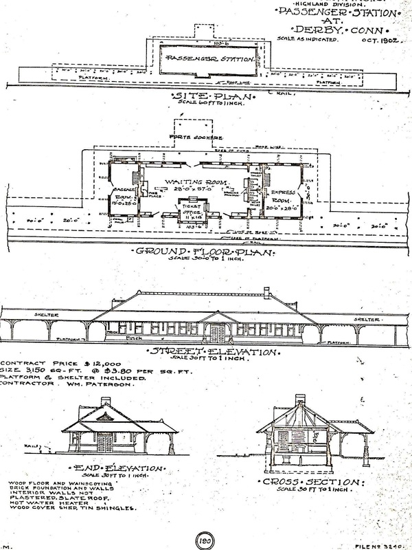
[4.63.5] These are the 10/1902 architectural renderings for the 1903 Derby depot, identified as being part of the Highland Division. These tracings were usually done for the railroad's files at a later date but none is seen. Phil Blakeslee says in Lines West [p16] that early in 1908 the Highland Division from Hartford to Hopewell Jct., NY was combined with the Naugatuck and Berkshire Divisions to form the Western Division. [rev033115]
Copyright NHRHTA
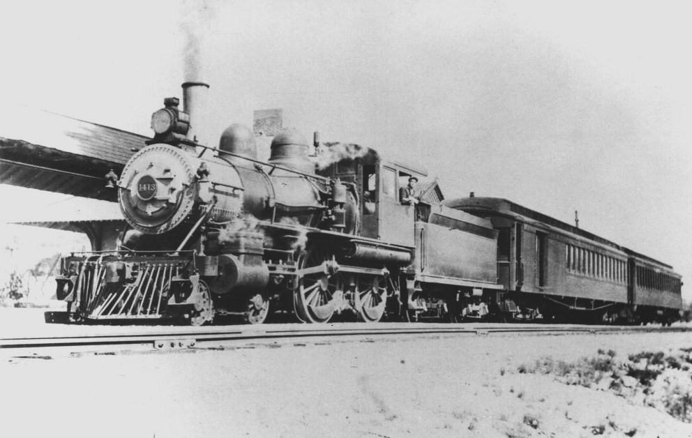
[4.63.6] This is a shot of #1413, a Class B-3, 4-4-0 unit built by Rogers in 1892, with 19x24-inch cylinders and 68-inch drivers. This was formerly HRR #56, and was renumbered into the NYNH&H roster in 1892 as #506. You can see the southern edge of the Derby passenger station and canopy to the left of the engine, which is headed toward Derby Jct. The two-car consist looks like one of the Ansonia locals that was the legacy of the NH&D. The date is sometime after the 1904 renumbering that made this engine the #1413 and 1920 when the ICC required electric headlights on all locomotives. Based all the evidence, the feeling is that this is ca. 1915. This engine was scrapped on August 31, 1925, the year in which Derby local passenger service was 'scrapped' as well.
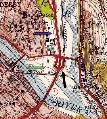
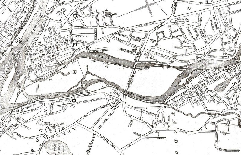
[4.63.7] This is a shot from the 1953 Ansonia USGS topographic quadrangle [click here]. It shows pretty much how things were left after the double-tracking and realignment of 1904 and before the 1955 floods. The purple arrow shows the old NH&D main left in place from the north down to the Farrel-Birmingham plant. Foundry St. is no longer seen because it was condemned in 1908 and the land was sold to FBI and the Sterling Co. The green arrow shows the old riverfront siding and the black arrow shows the 1917 wye to allow Maybrook eastbound freights to avoid the heavy grades on the Highland Division by coming down to Shelton and using the 'loop' here. Note how the three river islands have all been joined to the Derby mainland by now. Interestingly, the foundations of what was reportedly Derby's first factory, an 1836 copper mill, were recently discovered just above the green arrow [click here]. The factory, which was powered by water from the old Birmingham Canal, was built by Sheldon Smith and Anson Phelps, the latter of whom went off on his own to start other metals ventures in Derby's northeastern borough that would be named Ansonia after him. These operations evolved into Phelps, Dodge & Co, successor components of which are still in operation today. [rev033115]
Archives and Special Colls., UConn
[4.63.8] The Derby station and freight depot in the floods of 1955. Water seems to be up to the top of the covershed at the passenger station. The freight depot appears to be standing somewhat taller out of the water. This is identified as a Charles Gunn photograph taken in August, the first of the two floods of 1955.

|
|
|
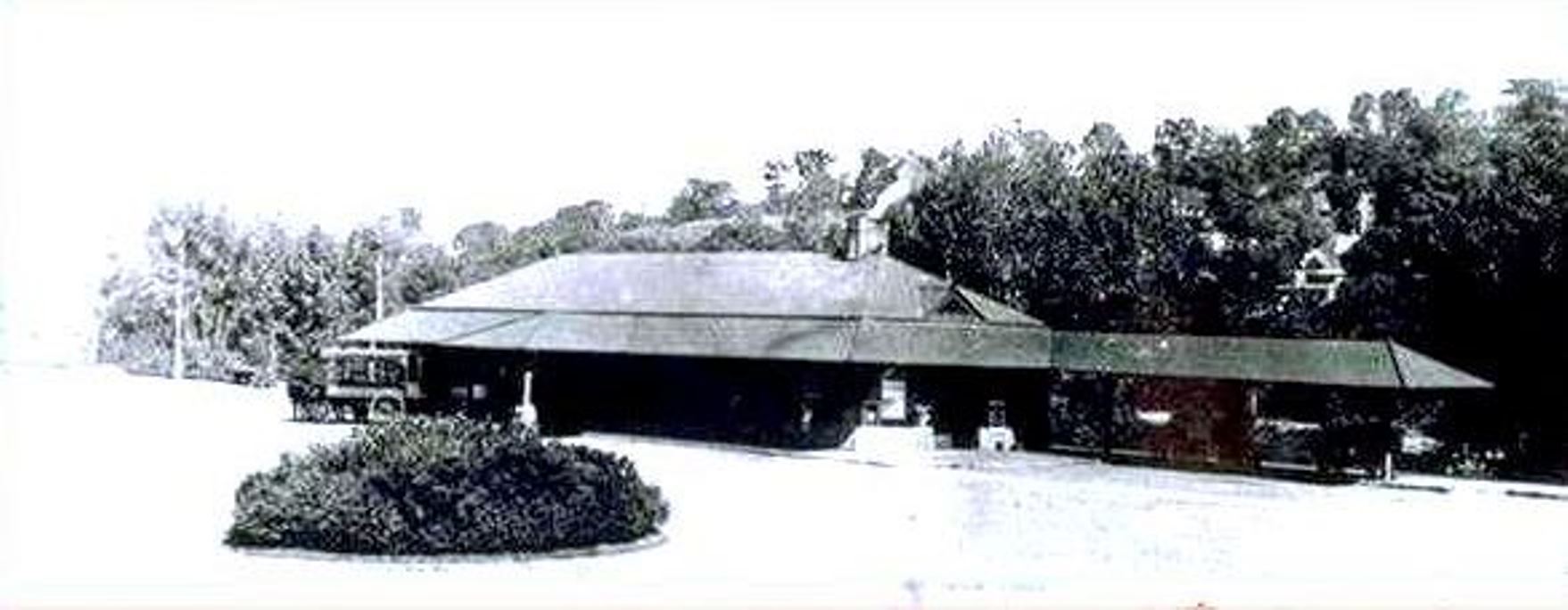
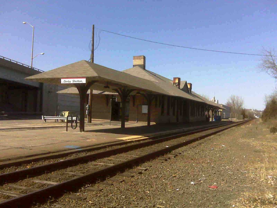
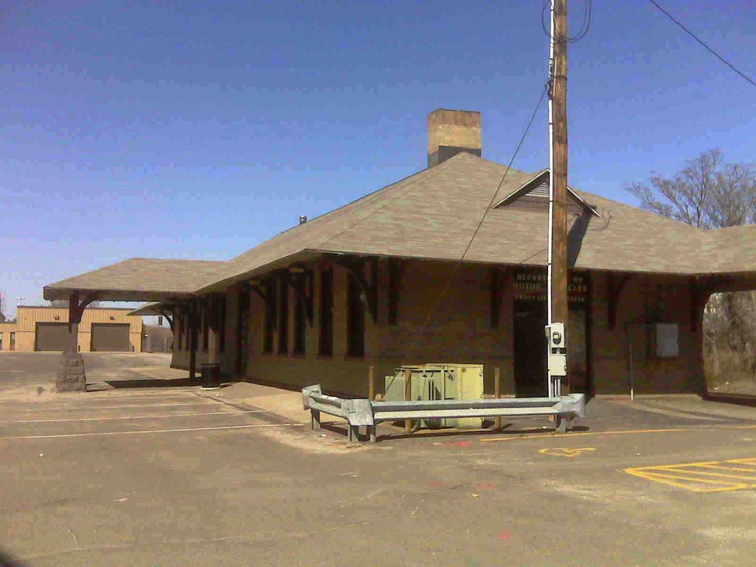
[4.64] The top left photo is from 1980 and shows just 'Derby' on the station sign. The other two views are of the station labeled Derby-Shelton station on March 21, 2009. Rte. 8 passes almost overhead and just to the west. The venerable structure looks quite sharp for having survived fire and flood. Even its signature porte cochere is still intact. Today the station serves as headquarters for the Valley Council of Governments covering Ansonia, Derby, Seymour and Shelton. The Valley Transit District operates from the building in the background in the shot at right. Along with CT Transit, it provides local bus service that stops here for passengers using the Metro-North Waterbury line. The transit garage sits on the site of the Derby freight house.
Dave Peters Collection
|
J.J. Harness, Copyright NHRHTA
|
J.J. Harness, Copyrught NHRHTA
|
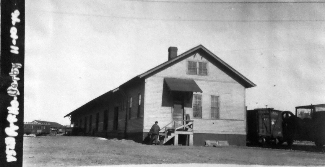
[4.64.1] The val photo at [1] is dated 11/10/1916 and shows the west side of the freight depot; there is a passenger car on the siding in the distance. J.J. Harness took additional valuation photos later. The 5/13/1931 view at [2] is similar to the preceding one and shows the side of the building where freight was transferred to wagons and trucks for local delivery. The view at [3] shows the east side of the building where rail cars on the siding were unloaded. [rev033115]
|
|
|

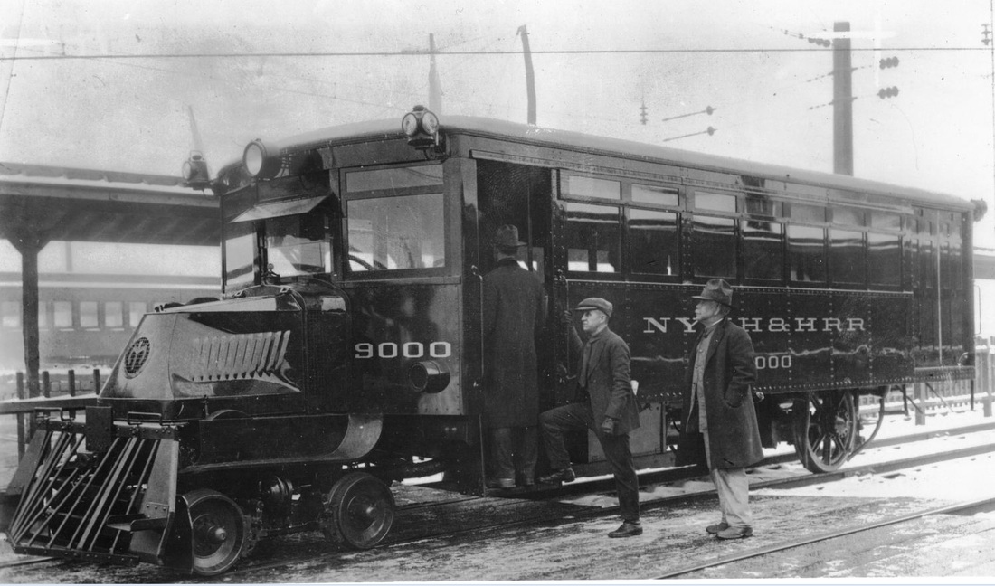
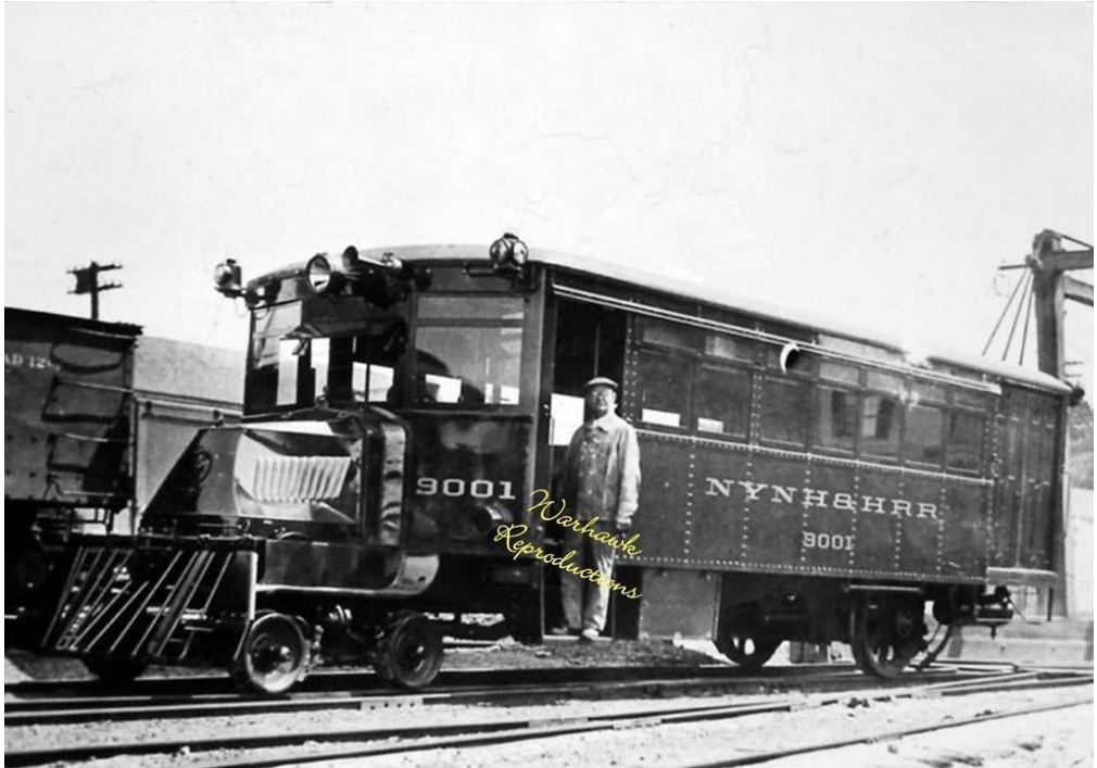
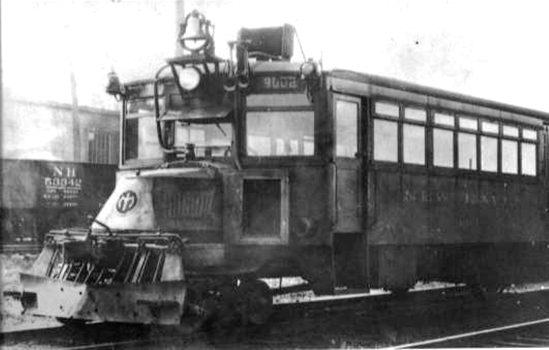
[4.64.2] The Derby line was to play host to new technology in 1922. An article in February issue of Railway & Locomotive Engineering that year, ran thusly: "The New Haven Introduces a Gasoline Car. A gasoline driven car, the first of its kind that has been put in operation on the New York, New Haven & Hartford Railroad, and known as No. 9000, has been placed in operation on the Derby division between Ansonia and New Haven, where the runs are short and the traffic not heavy. It is a combination of railroad car and automobile. In its initial trial trip it ran at a speed of thirty-five miles an hour. The car is twenty-eight feet long and a trifle over nine feet wide, and seats thirty-five people. Four feet of its length are reserved for baggage. The motor is the same as that used in a Mack truck, and can develop sixty horsepower. The total weight of the car when fully loaded is estimated at 20,000 pounds. Only two men will be needed to operate it—the driver and a man to act as baggage man and conductor—and it is understood that if it proves a success others of the same type will be put in service on other short runs of the system." Photos of the 9000, 9001, and 9002 are at top and the Courant announcement of the new equipment is at lower left. It is no coincidence that the railbus debuted here. The NH&D line had become something of a poster-child for ridership lost to CR&L trolley competition beginning on 12/12/1903. This attempt to cut costs and stave off the abandonment of passenger service here lasted only until June, 1925. [REFS: HC/01/08/1922/A5; RLE35.1.47 (2/1922)][rev040715]
Dave Peters Collection
|
Copyright NHRHTA
|
J.J. Harness, Copyright NHRHTA
|
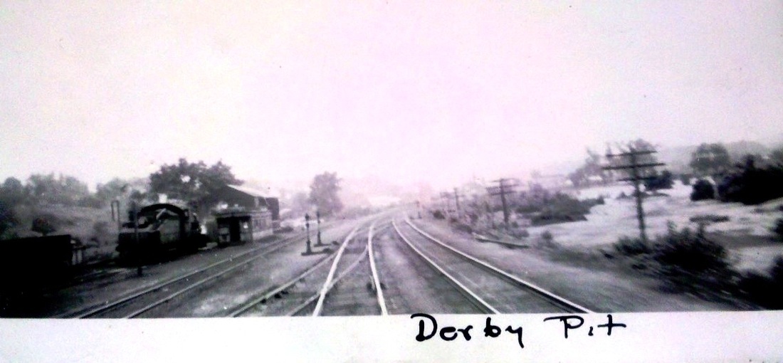
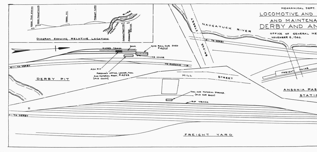
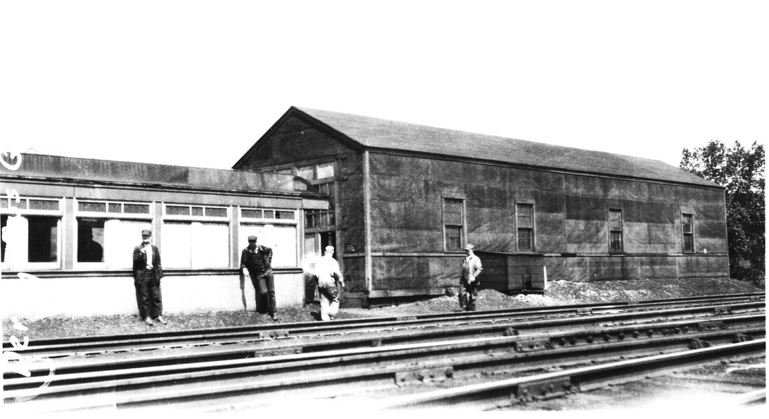
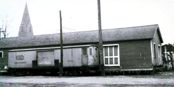
[4.64.3] The photo at left is a northerly look at the Derby Pit area on the west side of the Naugatuck line and so named either for the ash pit or the maintenance facility located here. The item at center is a 1940 map of the layout from the NHRHTA's reprint of a volume entitled New Haven Railroad - Mechanical Department Facilities Maps. The photo on the right is a westerly view and has 'Derby Bus Garage' written on the left side margin. The large engine house-like structure was apparently used to store and service the new Mack railbuses. An old coach was set up as a foreman's office and a locker, tool, and supply room for a crew to work on these new vehicles. Railbus service did last into the 1930s elsewhere and this 7/22/1929 photo likely indicates that servicing was done at this facility for some time after Derby line railbuses ran no more.
|
|
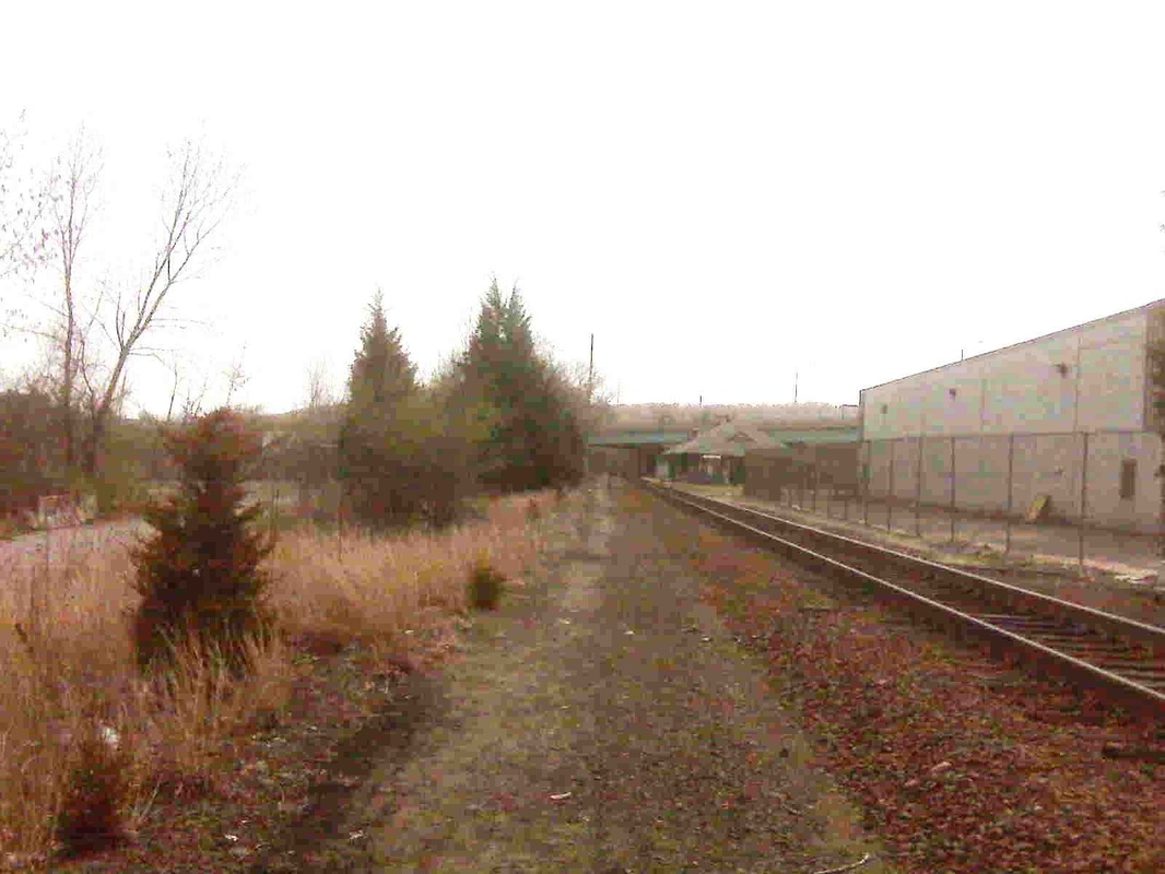
[4.64.4] Two views from the area north of the Derby-Shelton passenger station. The upper shot looks south and the station can be seen in the distance on the right. Looking north from about the same spot, we can see the track going off to the left where the old Derby Pit area was.

[4.64.5] Concrete loading dock, which dates to a later period than what is shown on the 1940 map above. This is probably the location of the 'old coach' that served as the foreman's office and tool room. The view looks north toward Division St.
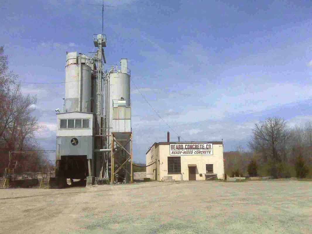
[4.64.6] We can't be quite certain but the old railbus facility may have stood where the Beard Concrete Co. building is now. If not, it was in the area in front of it. The Jersey barriers over on the right block off the area where the yard tracks slanted back into the main.
[4.64.7] The north end of the Derby Pit area still has rail in the ground that once went back into the main. This corresponds to the 1953 topographic map at MP 4.63.6 above, but on that map the tracks dead-end on the south. The 1940 map above shows the pit area tracks coming in from the south and dead-ending on the north. Obviously, some reconfiguration took place, even prior to 1953 and before the floods of 1955.
[4.64.8] This is along the Naugatuck line where Pershing Drive meets Rte. 8 to our right. The view looks south. The abandoned track on the right looks a remnant of the old southbound main, removed in the early 1960s. The switch up ahead is what we have arbitrarily decided to call 'NH&D Jct.' This 300-ft or so piece of track was put in 1903 or shortly thereafter to connect with the remnant of the NH&D, as shown on the 1953 topographic map. This was to reach BIF and the Sterling Co. after their rail access was cut off with the realignment.
[4.64.9] This overpass on Rte. 8 has no purpose at present. Back when this portion of the expressway was built in the late 1940s, it was needed for the BIF connection. Rails are still in the ground for the track that came off the Naugatuck line, which is now behind us as we are looking west. We accessed this spot from the parking lot of a small business off Water St. in Derby. The track bends around to our left on the other side of the overpass and ends as it goes toward where BIF once stood, now the site of a Home Depot. The Suburban Propane facility that is still on Water St. continued to get rail shipments via the B&M/Guilford reportedly until the fall of 1996 when an engine went on the ground there. The dirt road to the right dead-ends in the brush just behind us.

Derby Historical Society
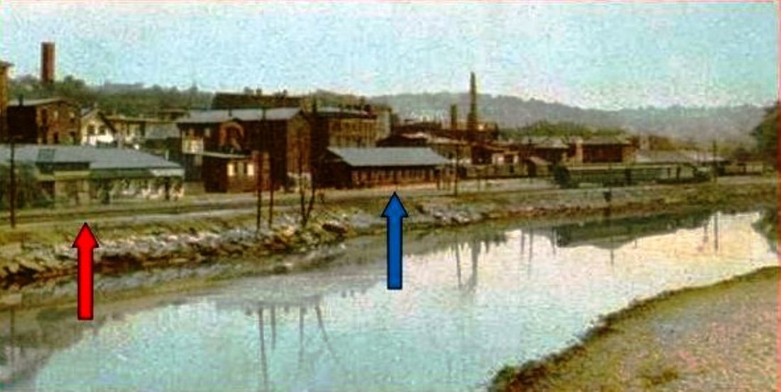
[4.65] Ansonia in 1856. The NRR is just seven years old, having opened to Derby on May 15, 1849, to Waterbury on June 11, and to Winsted on September 24 [NRRAR, 1850]. The first timetable was dated May 14, 1849. The 1849 Ansonia station (yellow arrow) appears to have been a combination facility for both passengers and freight, similar to the Derby station and others on the early NRR. The structure at the green arrow looks to be the engine house. In 1884, land for expanded facilities was purchased. They would be located at the foot of Bank St., a road not yet built, about where the double-tracking starts. The new brick passenger station did not open until January of 1887, at which time the engine house was also dismantled and moved to Wheeler's Farms in Milford as an NRR storage facility [NHWP/01/19/1887/04]. We do not yet know exactly when the freight depot opened but it may have been as early as the 1884 land purchase. It was built straddling the tail race that emptied water from the Ansonia canal back into the Naugatuck River (blue arrow). Like Shelton and Birmingham, the canal here powered Ansonia's factories. The canal is seen on this map running into the reservoir east of Main St. with the tail race flowing into the river on the left under the blue arrow. The land below Central St., which is at the red arrow, is where the railroad considered moving the freight operation ca. 1903. See below, especially MP 4.73.
Ansonia Library
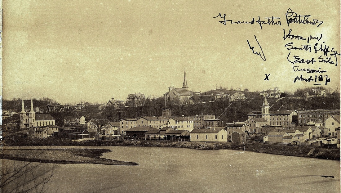
[4.65.1] This valuable panorama of Ansonia in 1870 is among the treasures we discovered in the historical room at the Ansonia Library [click here]. We deliberately did not crop out the family inscription pointing to the home of 'Grandfather' (J.H.) Bartholomew, third president of the NH&D. What is seen here is one of two surviving photographs, this one now newly examined, that shows the original 1849 NRR facilities, including the combination station, the large passenger shed to the right, and the engine house. The locations seem to correspond to the 1856 map above. The shed does not appear on the 1856 map, either not being considered a structure or not being built yet. It probably had to be taken down for the NH&D, which would build right along the riverbank, apparently filling in some areas and putting some of its track on trestle to squeak by the NRR complex. See the 1875 Bailey map below. The fact that the NH&D is nowhere to be seen verifies that this part of the road was not built as of 1870. Apparently the shed was never replaced, since it is not on the 1875 map either. This photograph appeared in the Register in 1963, misdated as ca. 1890 [NHER/04/26/1963/??].
|

Ansonia Library
|
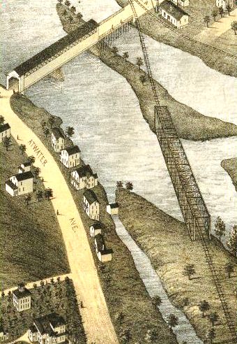
[4.65.2] The map view looks north. It corresponds perfectly with the shot from the 1875 Bailey bird's-eye map [click here]. This map is the only one ever seen to show Derby road facilities in Ansonia in any detail. The truss, carrying the NH&D across the Naugatuck River into Ansonia, is the 1871 bridge and the postcard corroborates its appearance. The brushy area on the north end of the truss is probably where the 'brigands' mentioned above [MP 4.59.1] hung out. Both views show the old half-covered structure that carried Bridge St. over the river. Also seen in the postcard view is the western end of the dam that spanned the entire river to help supply the Birmingham Water Co. canal.
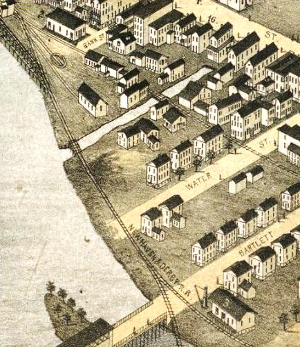
[4.65.3] This shot and the one below are also from the 1875 Bailey bird's-eye map. The appearance of a connection between the NH&D and the NRR at the passenger station may be one of those rare instances of carelessness by a bird's-eye artist. If a physical track connection was in place, it certainly was not used for the transfer of freight, a complaint of the NH&D [NHDP/03/08/1879/04] that was not addressed until the 1880 joint pooling agreement. The structure just below Bartlett St., also known as Bridge St. and so-named sometime after March, 1884 [NHER/03/06/1884/04], is identified in the map key as the NH&D station, which we know was for freight and was appropriately located on a spur track. It opened in December of 1871 [NHDP/12/09/1871/02] with a "switch track... to the lower wire mill" also being put in at this time. A John Morrissy was night watchman for the NH&D in Ansonia in early 1884 [NHER/03/14/1884/01]. Note the strategic placement of the pillar crane by the street enable it to hoist cargo from freight cars to wagons or the depot platform. The crane was likely made by the Farrel Foundry and Machine Company right here in Ansonia, similar to the one covered in the Scientific American issue of March 24, 1883. Click here. The Connecticut Eastern Railroad Museum recently moved a crane of this type from Middletown to Willimantic. Click here. The NRR station at Bank St. (top left) is the original one that was shared and used by passengers taking trains on both roads. James Montgomery Bailey, the famed 'The Danbury News Man,' rode through here in 1873 and had a few interesting things to say. He noted "a formidable line of huge cannon" at the Ansonia station, probably relics of the recently concluded Civil War in which he served. He says these were "condemned pieces brought here to be melted into less frightful forms" by a "brass company in Ansonia that employs six million dollars in capital, and would use more if it was to be got," probably referring to the Anson Phelps companies. Subscribing to less flattering views of the NH&D, he says... "Here the Derby railroad terminates its weary self. The intricate history of this route, if properly placed before a dead man, would make him squirm. If he didn't squirm, it would be on account of ill-health"(!). The exclamation point is ours. Mr. Bailey was known for his acerbic wit; he took the NRR from Bridgeport for his tour of the Valley.
|
|
|
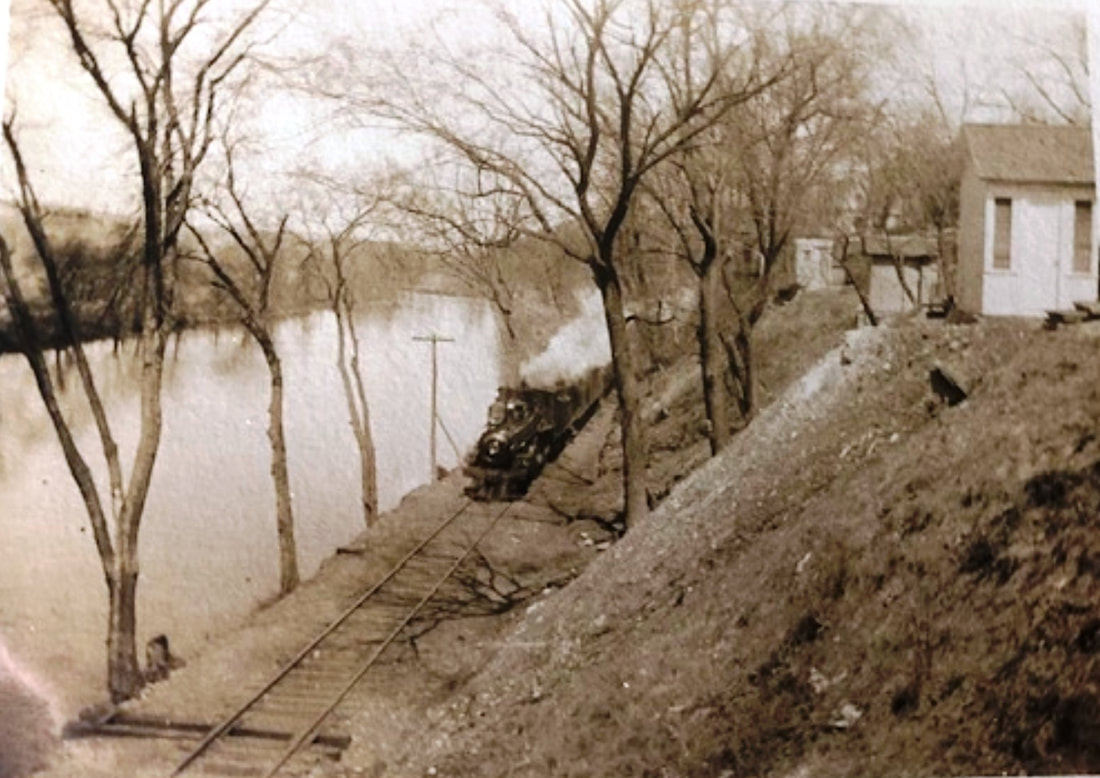
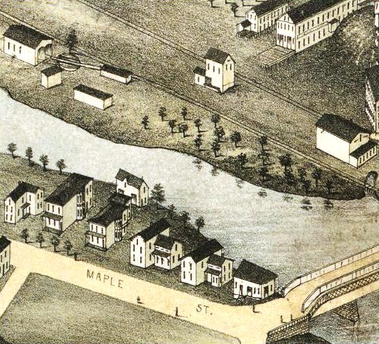
[4.66] The end of the NH&D line was above the Maple St. bridge in an area that was already heavily industrialized in 1871 and would become more so in the next decades. The freight traffic to and from here was undoubtedly the reason for extending the line to Ansonia in the first place. The bird's-eye map at [1] shows the two-stall Derby engine house and turntable in Wallace's Grove, apparently on land identified with the industrialist Wallace family. The woodcut at [2] shows an additional view of the property and the engine house. The turntable was in place early on to head NH&D engines back toward New Haven [DTR/08/11/1871/02]. The NRR track is to the right and continues on to points north. As late as January of 1891, Pres. Stevenson spoke of extending the NH&D by a third crossing of the Naugatuck River here where the newspaper said "extensive side tracks for freight and a new turning table are building" to accommodate the increased business after the HRR lease [NHER/01/06/1891/01; HRRAR 1890, p.5]. At the height of its succcess, there was talk of extending the NH&D all the way to Union City and Waterbury to compete for the vast amounts of industrial production the NRR, now leased by the NYNH&H, had always profited from. The factory area north of Maple St. would come to be the home of the massive Farrel complex. Heavy dependence on rail freight service, shown here perhaps ca. 1920, shows in the trackage, much of which is still in the ground today. As Metro-North rolls through here, staccato horn blasts for the empty crossings echo eerily off the walls of the buildings that are mostly vacant.
Derby Historical Society
|

Ansonia Library
|
[4.66.1] Down below, just off the NH&D's entry into Ansonia was the location of its freight house, two views of which are seen here on Bridge, originally, Bartlett, St. The original NH&D 1871 freight depot burned in 1885. It was then described as a 75x40-ft structure, with a total loss in the fire of $5,000. The NH&D was not liable to reimburse assignees for merchandise not picked up within 24 hours of delivery [NHER/06/08/1885/01]. Even prior to the fire, the newspaper said that the NH&D had been in discussion with the NRR about building a joint freight depot, probably the expansive 1884 structure seen below at MP 4.67, but that the NRR had reneged and the NH&D was going to rebuild on its own, at an expected cost of $1,500 to $2,000. The contract was given to T. Sharp of Seymour and the new structure was close to completion later in June [NHER/06/14/1885/04; NHER/06/26/1885/04]. The old pillar crane stands at the ready. The photo on the right is described in its attached caption as being at an old mill. We rather recognized this as the NH&D structure, complete with another first, an NH&D boxcar lettered 'D.R.R.' on the freight siding. The NH&D had boxcars right from the start, so this fact is of no help in dating the picture. We think, however, that this is the post-1885 structure with a somewhat different appearance than that on the 1875 map, including the building's longer eave overhanging the track on the west side.
Branford Electric Railway Association
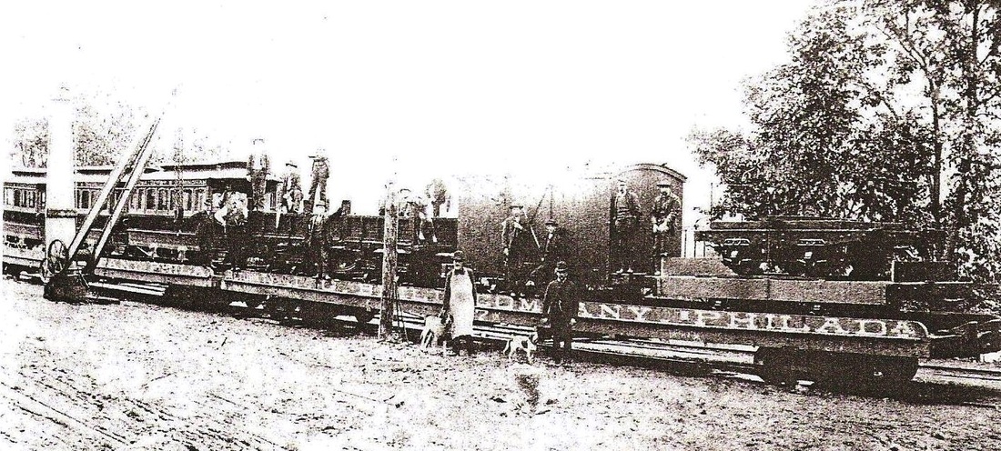
[4.66.2] This is a shot of the Ansonia, Derby & Birmingham trolley cars on the NH&D freight spur in Ansonia where they were delivered in the fall of 1887. The pillar crane is seen to the left. The new equipment sits on the flatcars of maker J.G. Brill. By January of 1888 [NHDP/01/07/1888/00] the trolley cars were moved to the AD&B facility at Main and Water Sts. near the NRR depot and the new cars were reportedly in service on the electric line by April [NHDP/04/25/1888/00]. The AD&B started as the Derby Horse Railroad in 1885 and subsequently had its charter amended to allow it to use electricity and to haul freight as well as passengers. For the former purpose it extended its Main St. Ansonia track down to the dock just below Derby Jct. There it connected with the new Naugatuck Valley Steamboat Co. formed in conjunction with the electric road. The plan was to take Ansonia's industrial products directly to New York and utilize electricity to undercut the rates the railroads were charging. The steam roads did, in fact, cut rates at this time, in response to the AD&B but also due to changes in railroad managements. The NH&D, now aligned with the HRR, and the NRR, leased by the NYNH&H in April of 1887, had just cancelled their 1880 freight-pooling agreement in October and began to compete vigorously. While one might wonder what role the opening of the AD&B played in these developments, the negative impact of the events on the AD&B is certain. Challenged by the increased competition, costly problems with the new technology, and the failure of its fragile boat connection, the freight operation ceased late in 1889. The historic AD&B electric freight engine lives today at the Shore Line Trolley Museum run by the Branford Electric Railway Association [click here]. AD&B passenger service endured and was absorbed in 1900 as part of the CR&L operation between New Haven and Derby that would soon drain riders from the old NH&D line.
Ansonia Library
|
|
[4.67] The view on the left shows the 1887 passenger station as well as the ca. 1884 freight house. The one on the right is a post card, probably ca. 1900. The freight house has been noticeably lengthened, perhaps subsequent to the 1887 lease of the NRR by the Consolidated. The NRR track runs behind it. It does not seem like the double-tracking, completed by mid-1904 to a mile or so north of Ansonia, is in yet, but it is hard to tell. This view is from Bridge St. just above the NH&D bridge over the Naugatuck River, which, since 1880, has been the covered bridge seen in the next photo.
Ansonia Library
|

Derby Historical Society
|
[4.68] In another rare photograph, we have a view of the covered bridge that the NH&D built in 1880 to replace the wooden truss bridge seen above at MP 4.65.2. The new bridge had iron support elements and possibly an iron deck as well. The structure, however, was primarily wooden and thus covered for protection from the elements. Compare this bridge to what is seen on the bird's-eye map at MP 4.60 for Derby Jct. This bridge burned on 6/10/1902 [HC/06/11/1902/13] and 70 trains per day were said to be using the NRR's track on the east side of the Naugatuck River until the bridge was replaced in the 1903 double-tracking. The photo also gives a clear picture of the Birmingham Water Co. dam, which spanned the Naugatuck in two sections and diverted flow into the canal. Seen in the background is the half-covered Bridge St. bridge linking east and west Ansonia. The bird's-eye map at right shows the covered railroad bridge at the red arrow, but the captioning in the Images of America Ansonia book [p53] ascribes the bridge to the NRR instead of the NH&D.
Connecticut Historical Society
[4.69] We weren't sure exactly where this photo belonged but something told us it was NH&D and we seem to be correct. On the right is the end of the new 1904 steel bridge [HC/02/03/1904/02]. The elliptical guard rails of the Bridge St. 'half-covered' bridge are to the left and the end of the covered portion is over to the far left. Construction work on the rail line is perhaps just finishing up the double-tracking. Note the two Hall 'banjo' signals on the water's edge and that must be the NH&D freight house behind them. The burning of the 1880 covered bridge on 6/10/1902 undoubtedly made the building of this one a higher priority than the building of the triple bridge at Derby Jct.
Ansonia Library
|
Ansonia Library
|
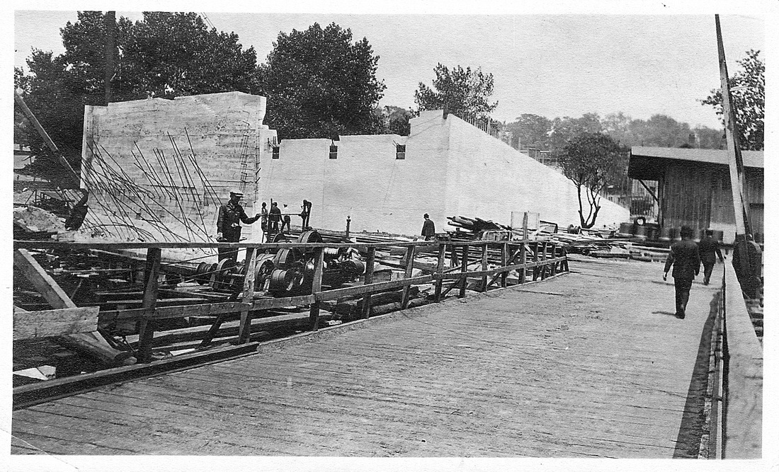
[4.70] These two scenes show the construction of the new Bridge St. bridge and viaduct over the railroad tracks near the NH&D freight house, which is still standing here in 1913. In the first shot, the corner of the freight house is seen at the right. We note that the pillar crane is gone, an indication that perhaps the depot was about to be taken down at this time. In the second shot, the freight house is perhaps out of sight to the right or has been demolished. The approach railings to the soon-to-be-taken-down, 'half-covered' bridge are shown with a sign warning drivers to 'hold their horses.' The new Bridge St. bridge was completed in 1914 and today's bridge was opened in 1960. [rev040615]
Ansonia Library
|
Richard A. Fleischer Collection
|
A.A. Lawrence, Copyright NHRHTA
|
[4.71] Three views of the NRR's sturdy brick Ansonia passenger station, that replaced the 1849 wooden combination depot. The growth in freight business undoubtedly contributed to the need for this. The postcard view at [1] is probably not long after the station opened in 1887 for use of NRR and NH&D passengers. The shot at [2] shows the double-tracking in place, hence is late 1904 or thereafter and the abortive 1903 station could be standing out of sight behind the photographer. Note the pillar crane, the water tower, and the water plug to the right of the station. The view at [3] is 1929. While the building date of this station has been somewhat difficult to clarify, a brief mention found in the Derby Transcript says that "the last touches are being given to the new depot" early in 1887 [DTR/01/12/1887/03]. George Porter was named NRR agent for the new station and moved his family from Bridgeport to Ansonia at this time [NHWP/01/20/1887/04]. The two aborted attempts at replacing this station left it still standing here, looking rather shabby and outdated in later years. At age 69, it was declared "beyond repair" after the 1955 floods [AES/12/29/1955/09] and the paper said the "roof was off the old station by noon today" as it was being demolished [AES/10/15/1956/04].
Ansonia Library
[4.72] The locomotive on the right is on the crossover from the Naugatuck track to the Derby line. This is where NH&D passengers would have boarded to go south to Birmingham, Derby Jct., or all the way to New Haven. The passenger station is just to the engineer's left. The large building with the five chimneys behind the engine and partially obscured by its exhaust was known as Terry Block #2, the structure immediately north of the Ansonia Opera House. This photo probably dates to the 1880s. The Maple St. bridge is out of sight to the left in the center. The area where the shacks are standing to the engineer's right would be the site of a new 1903 Ansonia passenger station.
Dodd Center, UConn
[4.73] Plans were announced late in 1902 for a new station to complement the one planned for DERBY as a culmination of the work on the new Naugatuck Division double track between the points. The new structure was almost finished at a cost of $20,000 when the railroad abandoned it [AES/10/27/1902/02; AES12/22/1902/03]. This was due to some dissatisfaction with the location, possibly exacerbated by basement flooding problems being right next to the river. This postcard view shows the 1903 station at the red arrow, standing north of the 1887 Ansonia station at the blue arrow. The white, pressed-brick structure reportedly stood unused for 10 years becoming a waterfilled, broken-roofed eyesore and health hazard. The sharp view here probably is closer to 1903 end of the date range. The railroad had reportedly 'confessed' in the meantime, that the design was meant for Beacon Falls, not Ansonia. [AES/09/06/1955/02]. This was perhaps a feeble attempt to save face, since a station of this size would probably not have been slated for the smaller manufacturing town up north. The embarrassment was revisited when the flood of 1955 uncovered the foundation for the 1903 structure. Ironically, if it had not, the railroad itself might have. It had just announced that it planned to build new passenger and freight depots north of the existing Ansonia station, probably where the forgotten construction lay buried for half a century [AES/01/19/1955/3,9].
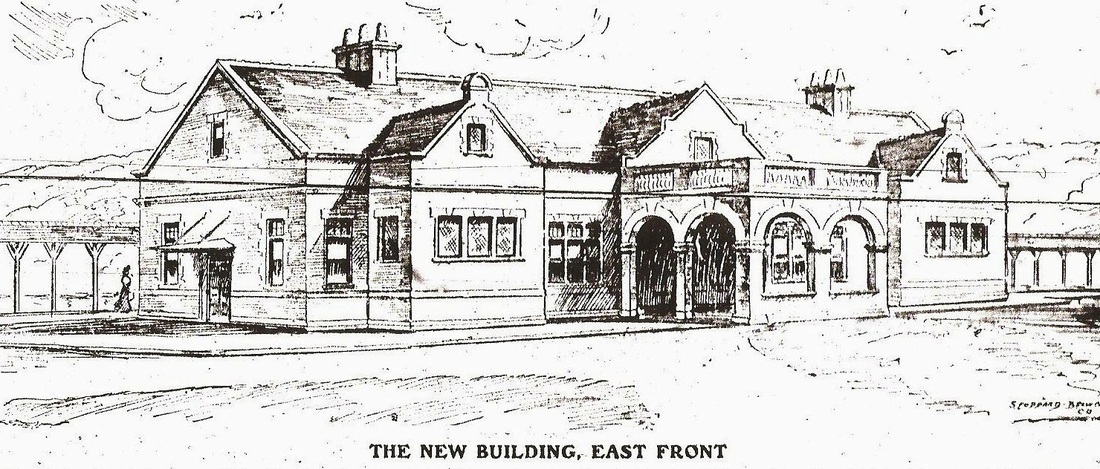
[4.74] This sketch appeared in the The Evening Sentinel on May 12, 1906. It shows the grand station plan for what was said to be "another new one of greater dimensions" to replace the unused 1903 station that the newspaper said was to be pulled down. The dimensions actually were not much larger [HC/07/20/1904/08]. This 125x32-ft English Renaissance structure was to have a porte cochere, a covered carriage porch, seen above, on the east side [ES/05/12/1906/01]. By late 1904 the railroad owned all the land west of the old NRR track between Bridge and Maple Sts. [ES/08/04/1904/03; ES/08/19/1904/03; ES/09/15/1904/02; ES/09/30/1904/04] and still more land was obtained in 1906 below Central St. [ES/08/02/1906/02]. Rumors again in 1908 was that work was starting on the new passenger station, though Charles F. Brooker, last vice president of the just-legally-expired NH&D as well as an NYNH&H director and Ansonia resident, said any such report was "news to him" [ES/12/16/1908/05]. By early 1909, the railroad was looking to build a new yard below Bridge St. possibly moving the freight depot to the site of the Ansonia Lumber Co. [ES/01/11/1909/02]. That plan was also abandoned. The new yard was built on the west side of the river between Bridge and Division Sts. and the freight depot stayed put until it was torn down in 1955. Whether any work was ever begun on the second attempt at a new passenger station for Ansonia and why it never came to fruition is unclear.
|
|
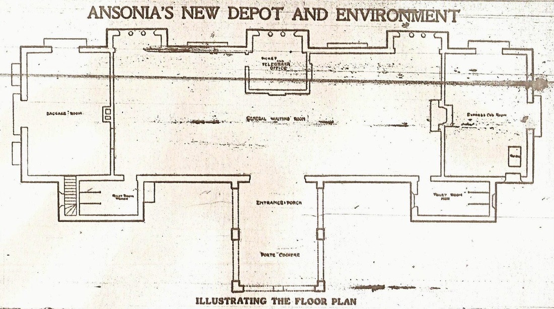
[4.75] Two more illustrations from the Sentinel, also on May 12, 1906. The one on the left shows the floor plan for the station pictured above and the one on the right the proposed new layout for the station area. The new location is between Bank and Water Sts. but considerably closer to Bridge St. and the river. The latter is interesting since one of the problems with the 1903 station was basement flooding. Nothing is shown at the site of that abandoned station by the Maple St. bridge even though it stood until 1910. Note the stub-ended track for Derby line trains at the south end of the new station here, as well as the new roadway approach from Main St. The old freight and passenger depots are in dotted lines indicating their planned removal, the former down to the areas discussed elsewhere below Bridge St. The exterior arc lights, indicated on the map and already in use on the station grounds, were fairly common by this time. Back in 1878, William Wallace, another notable Ansonia industrialist, had demonstrated a dynamo that could power several arc lights of 4,000 candle-power to a visiting Thomas Edison. Wallace was among those who backed the AD&B in 1888 and its pioneering use of electricity for motive power.

[4.76] So, in spite of efforts from 1902 to 1910 to give Ansonia new passenger and freight stations, the old structures lived on. This snippet is from the 1921 Hughes and Bailey map of Ansonia. A train is passing the 1887 Ansonia station heading for Derby. The 1903 station, if it were still standing, would have been in front of the last passenger car. Note the two-story office at the north end of the the freight depot just to the engineer's left. A fire would see the upper story cut off sometime after this, probably in the 1940s [ES/09/23/1955/03].
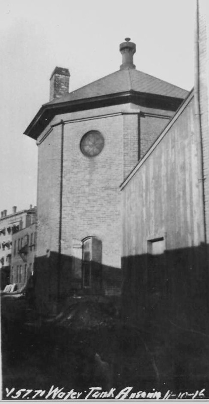
[4.77] The old brick water tank that may have dated back to NRR times is shown here in this 11/10/1916 val photo. It stood south of the passenger station and adjacent to the two-story freight office. It seems to be visible there in the image above at MP 4.69. By the 1920s it appears to have been replaced by a newer, legged structure seen on the map. See also ANSONIA2 on Track 12 for later shot of this tank. [rev061622]
|
|
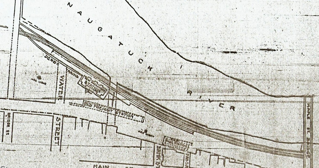
[4.78] The image at [1] is an enlargement of the Price & Lee Co. 1903 city directory map at [2]. The old NH&D freight spur [see MP 4.65] has been extended below Central St., probably along with the 1903 double-tracking. The new section (red arrows) shows here as reconnecting right at Beaver Brook with the old NRR main that ran along Canal St. The green arrow indicates where the new freight yard would be located ca. 1910 in the flats between the Birmingham Canal headwaters and the west bank of the river. The rights and properties of the Birmingham Water Co. were purchased by the NYNH&H in 1910. The dam was to be taken down and the canal was to be filled in to make way for the new freight yard. The dam is still seen on the map above starting at, and partially covered by, the upper red arrow and crossing the river to meet the canal intake channel. BIF, Sterling, and the Alling Mills were the major canal customers at the time and electricity was undoubtedly the new power source. [NHER/05/24/1910/01; HC/05/25/1910/02]. Today's Pershing Drive runs on some of the old canal bed. The old NRR main would later be severed (blue arrow), probably in 1914 with the new Bridge St. viaduct. The image at [3] is the 1921 bird's eye map showing the old NRR main running down Canal St. to Derby Jct. which it apparently did until rail was lifted in 1938 [AES/05/05/1938/02]. An S-connection appears to be in place at the right arrow; riverside track seems to dead-end but may also connect at left arrow below factory. By now plans for relocating the freight operations down here had been given up and the railroad was selling off the land it owned. The new yard is already in place across the river between Bridge and Division Sts. in the flats.
|
|
[4.79] At left is a shot of the Conn. Co. freight house from the 1921 map. Note the trolley express car parked on the north side of the depot, which stood west of Main St. The stub-ended trolley spur appears to be on or just below Cheever St., which was closed west of Main St. on the request of the company after the property was purchased. The Church of the Assumption on the corner of Main and Green Sts. is in the foreground. The view to the right is a 1937 photo. At one time the railroad considered moving its freight house here, buying all the property between Canal and Main Sts. down to Beaver Brook [ES/08/06/1906/02]. This may have been part of the plan to gain more space for the new passenger station. Rumor even had it that Pres. Mellen was considering tranferring the railroad shops just moved from New Haven to Readville, Mass. back here [ES/07/04/1904/03; ES/07/26/1904/03]. Among the reasons cited was worker discontent with relocation to Readville and the withdrawing of free passes on the railroad for their use in coming back to their homes in New Haven. The railroad was also said to be dissatisfied with Readville's distant location. It is unclear what derailed these plans.
Copyright NHRHTA
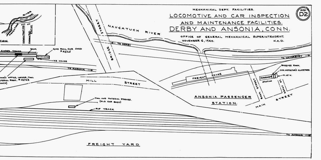
[4.80] This is the north end of the 11/6/1940 map seen at MP 4.64.3. Details for Ansonia are at the right. Note the appearance of 'Depot St.' from Main St. to the north end of the passenger station, and the large width of the canal tail race which runs under the freight house. Track detail is also shown for the 1910 freight yard on the west bank of the Naugatuck River. On the southern end, the started in the flats around Division St and tapered back into the main on the north end prior to the crossing of the river into Ansonia.

|
|
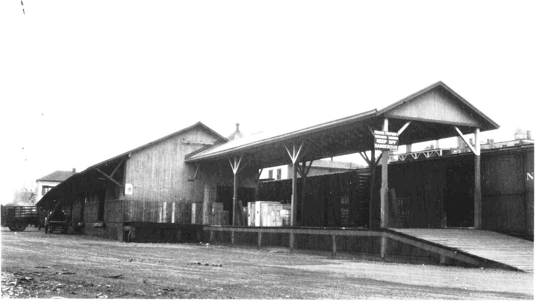
[4.81] Two 1927 views of the block-long 1884 Ansonia freight house. The shot at left is of the north end and shows the two-story office wing. The val photo at right was taken by J.J. Harness on 2/6/1927 and looks north from the south end of the structure. There are Wabash and New Haven boxcars on the siding along the platform. In the left distance you can just make out the FARR in the Farrel Foundry and Machine Co. sign. Also visible is the train order signal in front of the passenger station just to the left of the freight office, a horse-drawn wagon in the driveway, and the ventilator on top of the water tank over the freight-house roof. The exterior of the freight house is looking pretty weathered at this point but the structure would last until the flooding of 1955.

|
|
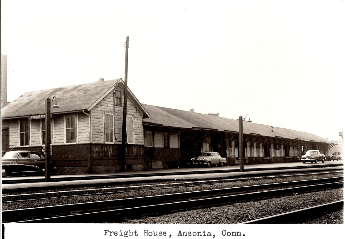
[4.82] The Ansonia passenger station and freight house in the mid 1950s, just before the deluge. The freight office is now single-storied after a fire that reportedly occurred in the 1940s.
[4.83] This shows the scene after the flood of August, 1955, the passenger station being at the blue arrow and the freight depot at the red arrow. The newspaper reported that the flood tore the entire depot off the brick piles on which it stood "so that the platform and roof were bent and twisted like a toy." The railroad lost no time in announcing that the freight depot would not be rebuilt and that operations would be moved to Derby [ES/0826/1955/04]. The fact that it sat astride the old canal's tail race, which still served as a channel for storm runoff, probably did not help. The building was cut in half to free up the debris, the sight of which was described by U.S. Senator Prescott Bush as "the most horrible thing he has ever seen" [ES/09/06/1955/07]. In addition to the ugliness, the backed-up water was preventing the flooded streets from draining. Firemen watched over a funeral pyre as the remnants of the structure were burned to clear the area. [ES/09/20/1955/05; 09/23/1955/03]. Click here for more on the old canal and tail race.

Archives & Special Collections, UConn
|
Archives & Special Collections, UConn
|
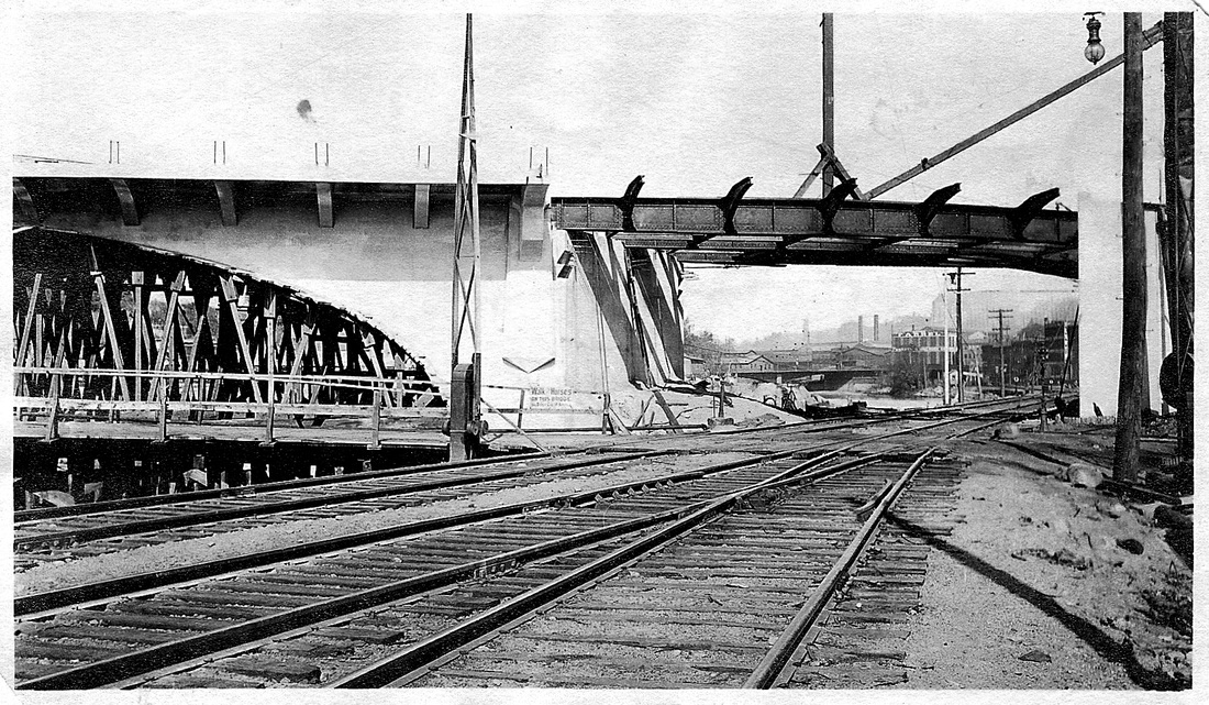
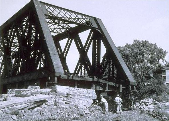
[4.84] Two views of the 1903 single-deck, double-tracked, two-span bridge that replaced the 1880 NH&D covered bridge across the Naugatuck River. This one was built by the American Bridge Co. and was being finished as they were starting the more complex construction on the triple bridges at Derby Jct. [ES/12/09/1903/09]. Progress on the latter was delayed by labor strife that culminated in an unsuccessful attempt to dynamite this bridge [HC/02/12/1904/01; HC/02/16/1904/08; HC/05/18/1904/12]. The shot at left shows the line washed away on the southern end in 1955. The large manufacturing facility on the east bank of the river is Ansonia Brass and Copper Co., locally known as A.B.&C., the later evolution of the companies Anson Phelps founded. The view at right is of workers surveying the damage. We have reversed the image here since this seems to be the north end looking over to houses on the west side of the river. All of the steel bridge structures in the lower Valley held their positions pretty well against the rampaging waters.
[4.85] Even after the floods of 1955, a few ties remained as late as 1980 along the old NRR right of way. If memory serves, this is around the end of Chestnut St.
[4.86] The end of the line, in more ways than one. Ansonia had been a stop on the NRR since 1849 and was the terminus for the NH&D, both when it opened in 1871, when it became part of the HRR in 1887, and even into the NYNH&H era through 1925 for local passenger service to New Haven. After the floods of 1955, Ansonia was never to have a station building again. The shelter seen here was the only thing built after the flood, in spite of the railroad's promises, however genuine, and the official protests against what was called a "fourth rate shed" [ES/02/20/1956/04]. The mayor complained that the railroad had received $10M to restore facilties to their pre-flood condition, apparently to no avail [ES/02/18/1956/02]. All those years of railroad service reduced to this. At least the Metro-North Waterbury branch endures today. [rev040515]
Click here to ride the Extension, Derby Jct. to Botsford...
Click here to ride the Extension, Derby Jct. to Botsford...