Track 12: CT Passenger Stations, B-BO
See TCS Home Page links for notes, abbreviations, and sources.
Use Track 11 map link to locate stations, rail and trolley lines, and POIs.
Use Track 11 map link to locate stations, rail and trolley lines, and POIs.
|

|
|
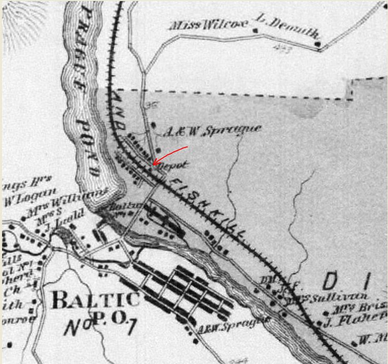
BAILEYS [HP&F, c1868?]
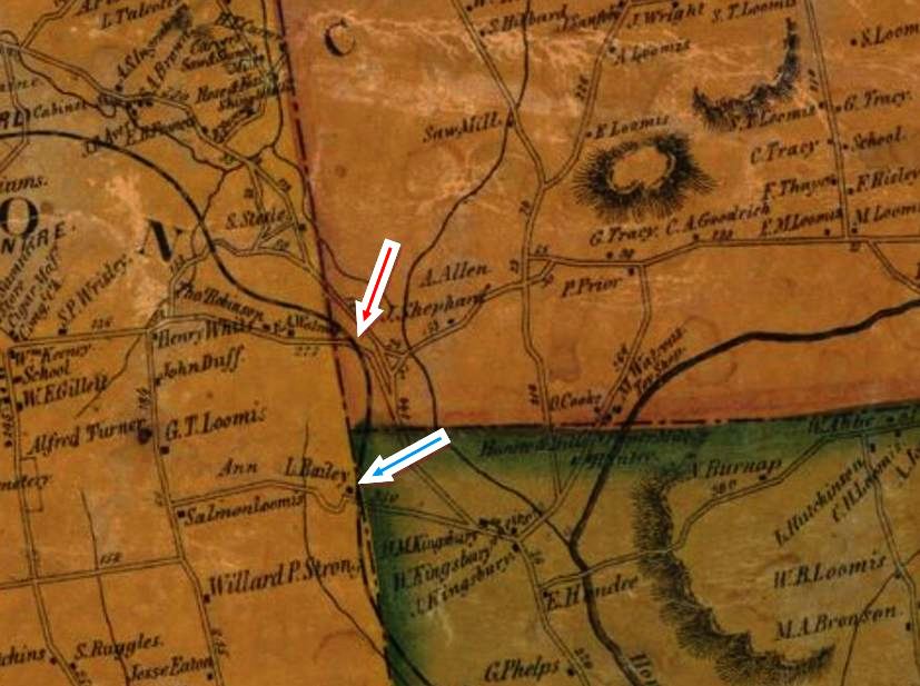
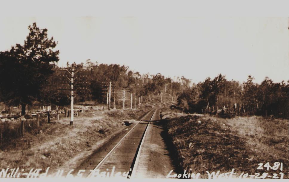
Clarifying the exact location of this obscure station is problematic because we have no timetable mileage points, the roads and their names have changed over the years, and the town boundaries of Coventry, Bolton and Andover all intersect here. The stop, about halfway between ANDOVER and BOLTON, is first mentioned in 1868 newspaper articles that said group excursions were coming "to Cold Spring Grove, at Bailey's Station..." and to Bailey's Crossing where they "were landed literally at the grove." The next report in 1870 has the Orient Lodge of the Good Templars from Hartford journeying for a picnic. The first official appearance we have is on our 1872 HP&F timetable and we find it again in the 1877 Pathfinder guide at [4]. Mentioned specifically in an 1876 reference to a namesake Bailey family event, the stop is seen in the RRMs issued from the first issued in 1876 until 1881, by which time the stop may have been discontinued. The 1857TC map at [1] shows two possible locations. Our thinking is that it was at the Bailey Road crossing in Bolton just west of the Andover line [blue arrow] where we see the family surname but the 1915 val map at [2] has BAILEYS, seemingly labeled as a station with a small structure [red arrow], just over the Coventry line to the north. The 10/25/1927 PUC photo at [3] looks west from the crossing that presumably corresponds with today's Bailey Road, seen at the blue arrows on the maps. We do not know what, if any, depot ever stood here. Adding to the uncertainty is the fact that BAILEYS does continue to appear until 1913 in the Geer's directories but has yet to be found on any other list or timetable in the NYNH&H era. [REFS: PTH117.1858.11: no; HDC/07/23/1868/02; CC/08/02/1868/01; HDC/07/16/1870/02; HPF9/18/1872TT: yes; PTH421.1875 .17: yes; CC/04/06/1876/04; HPF12/03/1877TT: yes; PTH458.1878. 35: yes; PTH470.1879.34: no; RRM1876-1881: yes, 1882: no; GHD1879-1913: yes; 1907TT, 1911TT: no][rev121216]
Clarifying the exact location of this obscure station is problematic because we have no timetable mileage points, the roads and their names have changed over the years, and the town boundaries of Coventry, Bolton and Andover all intersect here. The stop, about halfway between ANDOVER and BOLTON, is first mentioned in 1868 newspaper articles that said group excursions were coming "to Cold Spring Grove, at Bailey's Station..." and to Bailey's Crossing where they "were landed literally at the grove." The next report in 1870 has the Orient Lodge of the Good Templars from Hartford journeying for a picnic. The first official appearance we have is on our 1872 HP&F timetable and we find it again in the 1877 Pathfinder guide at [4]. Mentioned specifically in an 1876 reference to a namesake Bailey family event, the stop is seen in the RRMs issued from the first issued in 1876 until 1881, by which time the stop may have been discontinued. The 1857TC map at [1] shows two possible locations. Our thinking is that it was at the Bailey Road crossing in Bolton just west of the Andover line [blue arrow] where we see the family surname but the 1915 val map at [2] has BAILEYS, seemingly labeled as a station with a small structure [red arrow], just over the Coventry line to the north. The 10/25/1927 PUC photo at [3] looks west from the crossing that presumably corresponds with today's Bailey Road, seen at the blue arrows on the maps. We do not know what, if any, depot ever stood here. Adding to the uncertainty is the fact that BAILEYS does continue to appear until 1913 in the Geer's directories but has yet to be found on any other list or timetable in the NYNH&H era. [REFS: PTH117.1858.11: no; HDC/07/23/1868/02; CC/08/02/1868/01; HDC/07/16/1870/02; HPF9/18/1872TT: yes; PTH421.1875 .17: yes; CC/04/06/1876/04; HPF12/03/1877TT: yes; PTH458.1878. 35: yes; PTH470.1879.34: no; RRM1876-1881: yes, 1882: no; GHD1879-1913: yes; 1907TT, 1911TT: no][rev121216]
Bock-Elker Collection
|
|
|
Bock-Elker Collection
|
|
|
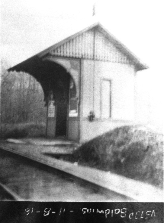
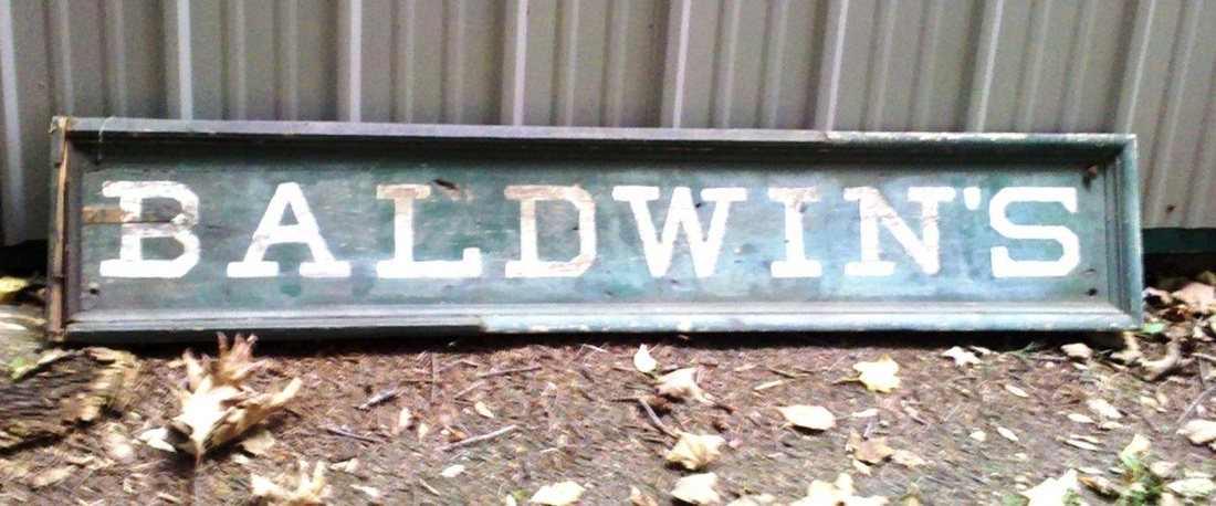
BALDWINS [NRR, 1849; depot, c1880]
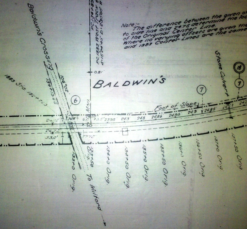
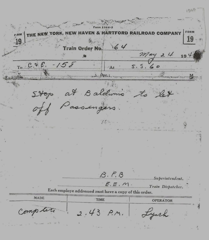
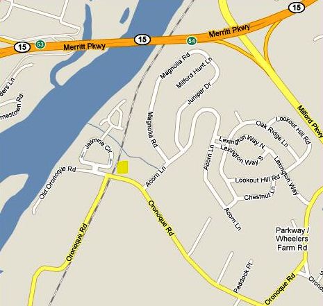
This was an original NRR flag stop in the town of Milford from 1849, 2.49 miles north of NAUGATUCK JUNCTION. It made news in 1858 when a $100 reward was offered by the railroad "for the arrest and conviction of the scoundrels who placed the rail across the track... near Baldwin's Platform, on the evening of October 16." The 11/8/1916 val photo at [7] shows an 1880s-vintage shelter like ones at BROWNS and REYNOLDS BRIDGE and, indeed, an 1882 newspaper article refers to this stop as Baldwin's Station, perhaps an indication of the shelter being built where there was likely only a platform in the past. The BALDWINS signboard survives today, seen at [6] as do the brackets, seen at [2], that later adorned the chicken coop of a local farm. The photo at [1] shows a train approaching but the pole mechanism does not appear to be turned to show the white 'stop' flag. Perhaps this is a regularly scheduled train before the 1925 service cutbacks. The 6/30/1915 val map at [3] shows the layout at that time. BALDWINS still shows as a timetable flag stop in 1923 but no longer by 1928. In spite of that and though the station structure was gone by the late 1940s, local residents still accessed trains for New York here. The Form 19 train order at [4], with the 1949 date from the original inserted on this photocopy, instructs the conductor and engineer of Train 158 on Tuesday, May 24 to let passengers off at BALDWINS. This train is The Naugatuck, running through from Grand Central Station to Winsted daily except Sundays. The order was given to the crew at SS-60, Peck Tower, on the Pequonnock River drawbridge at Bridgeport. The map shows the location of this stop on today's Oronoque Rd., a street name that came, interestingly, from across the river as did also the Baldwin name. The WPA's tercentenary history of Milford says that Zachariah Baldwin was given 'liberty to set up a ferry at the said Oronoque" in Stratford in 1723 and that "the landing on the Milford side of the river was at the point where Oronoque Road goes down to the river bank." Hence, the word 'crossing' here was due not to the railroad, but rather to the ferry that plied the river from Stratford. Our thanks to Richard Platt, Milford city historian, for this reference. [REFS: RF/06/26/1849/03; HDC/10/23/1858/02; CR/09/01/1860/02; NHER/10/06/1882/04; C92; 12/2/1923TT, 11/18/1928TT, 4/25/1948TT; History of Milford Connecticut, 1639-1939, p46][rev121216]
This was an original NRR flag stop in the town of Milford from 1849, 2.49 miles north of NAUGATUCK JUNCTION. It made news in 1858 when a $100 reward was offered by the railroad "for the arrest and conviction of the scoundrels who placed the rail across the track... near Baldwin's Platform, on the evening of October 16." The 11/8/1916 val photo at [7] shows an 1880s-vintage shelter like ones at BROWNS and REYNOLDS BRIDGE and, indeed, an 1882 newspaper article refers to this stop as Baldwin's Station, perhaps an indication of the shelter being built where there was likely only a platform in the past. The BALDWINS signboard survives today, seen at [6] as do the brackets, seen at [2], that later adorned the chicken coop of a local farm. The photo at [1] shows a train approaching but the pole mechanism does not appear to be turned to show the white 'stop' flag. Perhaps this is a regularly scheduled train before the 1925 service cutbacks. The 6/30/1915 val map at [3] shows the layout at that time. BALDWINS still shows as a timetable flag stop in 1923 but no longer by 1928. In spite of that and though the station structure was gone by the late 1940s, local residents still accessed trains for New York here. The Form 19 train order at [4], with the 1949 date from the original inserted on this photocopy, instructs the conductor and engineer of Train 158 on Tuesday, May 24 to let passengers off at BALDWINS. This train is The Naugatuck, running through from Grand Central Station to Winsted daily except Sundays. The order was given to the crew at SS-60, Peck Tower, on the Pequonnock River drawbridge at Bridgeport. The map shows the location of this stop on today's Oronoque Rd., a street name that came, interestingly, from across the river as did also the Baldwin name. The WPA's tercentenary history of Milford says that Zachariah Baldwin was given 'liberty to set up a ferry at the said Oronoque" in Stratford in 1723 and that "the landing on the Milford side of the river was at the point where Oronoque Road goes down to the river bank." Hence, the word 'crossing' here was due not to the railroad, but rather to the ferry that plied the river from Stratford. Our thanks to Richard Platt, Milford city historian, for this reference. [REFS: RF/06/26/1849/03; HDC/10/23/1858/02; CR/09/01/1860/02; NHER/10/06/1882/04; C92; 12/2/1923TT, 11/18/1928TT, 4/25/1948TT; History of Milford Connecticut, 1639-1939, p46][rev121216]
|
|

|
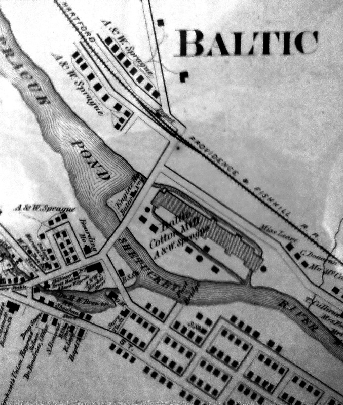
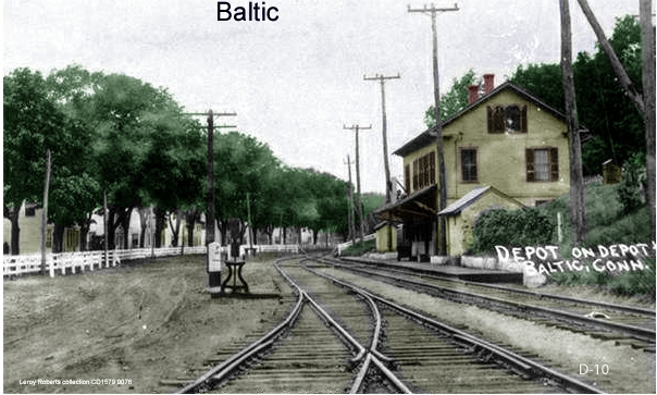
BALTIC1 [HP&F, 1856?]
This village in the town of Sprague was formed around a cotton mill established along the Shetucket River on land purchased in 1856 by William Sprague, a former Rhode Island governor and U.S. senator. According to the HP&F annual report of 1857, this location was first called LORDS BRIDGE and, while it may have been an original stop when the railroad opened in 1854, the first timetable we have that shows it is 1858. We have no photograph yet of the presumably modest BALTIC1 that preceded our next entry and what happened to this first depot is not known. One possibility is that it fell victim in 1876 when the newspaper reported that "the whole of the village is submerged and the people homeless," after storms caused the dam to break. While the railroad station is not spoken of as a casualty, one wonders how it could have survived when 155 feet of the "Mammoth mill" had been destroyed, some 25 feet of it entirely carried away. The complex burned in 1887 and was rebuilt as the Baltic Mills Co. in 1899 and it went up in flames, a century later, in 1999. The town of Sprague was looking for investors to purchase the vacant site in 2014 when we last checked; rail service is still available of course, on the old NLN line. [REFS: HPFAR8.1857.11; HDC/03/27/1876/03; BH/10/15/1887/04; NB/09/18/2010/00] [rev12 1216]
This village in the town of Sprague was formed around a cotton mill established along the Shetucket River on land purchased in 1856 by William Sprague, a former Rhode Island governor and U.S. senator. According to the HP&F annual report of 1857, this location was first called LORDS BRIDGE and, while it may have been an original stop when the railroad opened in 1854, the first timetable we have that shows it is 1858. We have no photograph yet of the presumably modest BALTIC1 that preceded our next entry and what happened to this first depot is not known. One possibility is that it fell victim in 1876 when the newspaper reported that "the whole of the village is submerged and the people homeless," after storms caused the dam to break. While the railroad station is not spoken of as a casualty, one wonders how it could have survived when 155 feet of the "Mammoth mill" had been destroyed, some 25 feet of it entirely carried away. The complex burned in 1887 and was rebuilt as the Baltic Mills Co. in 1899 and it went up in flames, a century later, in 1999. The town of Sprague was looking for investors to purchase the vacant site in 2014 when we last checked; rail service is still available of course, on the old NLN line. [REFS: HPFAR8.1857.11; HDC/03/27/1876/03; BH/10/15/1887/04; NB/09/18/2010/00] [rev12 1216]
|
|
|

|
|
|

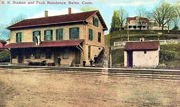
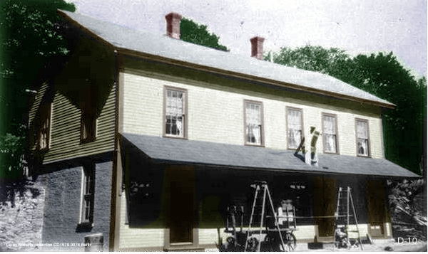
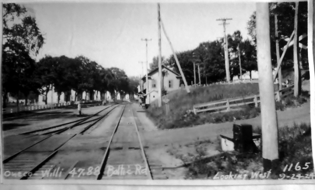
BALTIC2 [HP&F, 1881?]
This two-story depot looks very much like PLAINFIELD/H2 that we know was built in 1881, but we find no specific mention yet of this one coming in either the annual reports or the newspapers. An 1881 article in the Boston Herald does say that a new freight house was being planned for here and perhaps this large combination station came instead, if not in 1876 as discussed in the previous listing. The upper items are undated but we do note the harp switch in the image on the left, which would definitely make it the earliest, likely a late 1800s, view. The val map at [4] shows the passenger station arrangement in 1915 -- just east and across the the street, the adjoining map shows several sidings, a large storehouse and a freight depot -- and the PUC photo at [5] was taken on 9/24/1924. The val photo at [7] is dated 6/18/1917. Passenger service on this line ended ca. 1927 and this depot is no longer standing. At [6], MBRE's Advance Willimantic Special from Worcester brings a train by the station site on 10/13/2012. [REFS: BH/03/05/1881/06; C175; K84; PTH107.1858.11; R33] [rev121216]
This two-story depot looks very much like PLAINFIELD/H2 that we know was built in 1881, but we find no specific mention yet of this one coming in either the annual reports or the newspapers. An 1881 article in the Boston Herald does say that a new freight house was being planned for here and perhaps this large combination station came instead, if not in 1876 as discussed in the previous listing. The upper items are undated but we do note the harp switch in the image on the left, which would definitely make it the earliest, likely a late 1800s, view. The val map at [4] shows the passenger station arrangement in 1915 -- just east and across the the street, the adjoining map shows several sidings, a large storehouse and a freight depot -- and the PUC photo at [5] was taken on 9/24/1924. The val photo at [7] is dated 6/18/1917. Passenger service on this line ended ca. 1927 and this depot is no longer standing. At [6], MBRE's Advance Willimantic Special from Worcester brings a train by the station site on 10/13/2012. [REFS: BH/03/05/1881/06; C175; K84; PTH107.1858.11; R33] [rev121216]
|

|
|
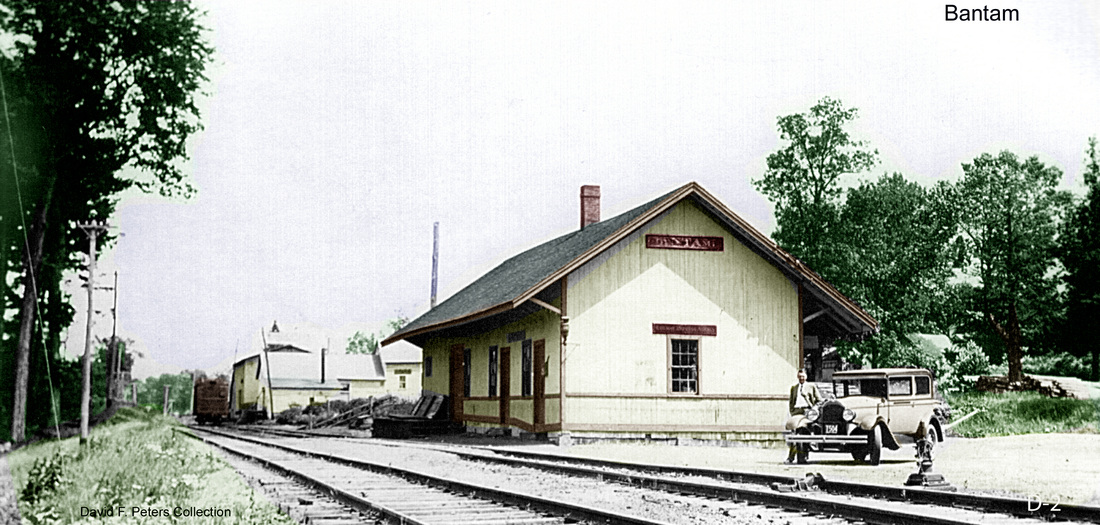
BANTAM [SRR, 1872]
This was an original stop in the town of LITCHFIELD on the Shepaug RR which opened in 1872 and this depot debuted with the railroad. This is the only station we have ever seen pictured here and it is no longer extant. Passenger service ended on the line in 1930. [REFS: D138; K60; R35][chk121815]
This was an original stop in the town of LITCHFIELD on the Shepaug RR which opened in 1872 and this depot debuted with the railroad. This is the only station we have ever seen pictured here and it is no longer extant. Passenger service ended on the line in 1930. [REFS: D138; K60; R35][chk121815]
BARKHAMSTED [CW, 1871]
The only place we have seen this stop listed is on a George Cram map [RAM c1905], where it is shown to be two miles east of EAST WINSTED. There was no stop here when the Connecticut Western RR opened and it is not even in the town statistics section in RAM1908. We will be on the lookout, but we may have to conclude that the map is in error. Though there was a siding here, no other map or timetable shows an actual station at this location. [REFS: HDC/12/21/1871/02][rev121216]
The only place we have seen this stop listed is on a George Cram map [RAM c1905], where it is shown to be two miles east of EAST WINSTED. There was no stop here when the Connecticut Western RR opened and it is not even in the town statistics section in RAM1908. We will be on the lookout, but we may have to conclude that the map is in error. Though there was a siding here, no other map or timetable shows an actual station at this location. [REFS: HDC/12/21/1871/02][rev121216]
BARNARDS [> NORTH BLOOMFIELD]

|
|

|
|
|
|
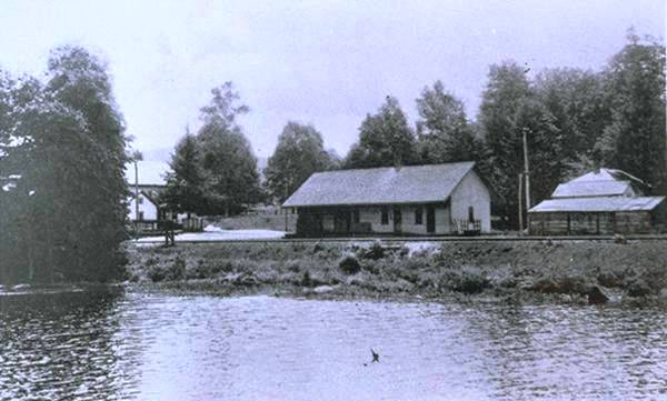
BARTLETTS [NLN, c1880; depot?]
The first reference we have come across is to a place where track work was done and not necessarily a station [1]. The stop is seen at the red arrow on the 1893 topo map [2], about two miles above the NLN's WATERFORD station and within the border of that town and MONTVILLE. The first RRM we see it on is 1881, along with the debut of all the lower CVT stops, and it may have come about with the Yale-Harvard regattas when Bartlett's Cove began figuring as a start or finish point. These gala and highly anticipated annual events, along with the use of railroad cars to observe the contest, began in 1878 when "a train of 25 platform cars, each capable of accommodating 80 persons" was to be run by the N&W under its NLN trackage rights on the west side of the Thames River. The NYNH&H continued the observation-train tradition and new, larger cars made their debut in 1930. The 1917 valuation map [3] shows no station structure and we do not know what, if anything, ever stood at this stop. The 1926 Official List [4] shows BARTLETTS as an unmanned station but ETT #5 (4/26/1936) [5] does not have it where our red arrow would expect it among adjacent flag stops of HARRISONS and SCOTCH CAP. Perhaps it was only in service for the races by this time. The Track 11 map snippet [6] shows the location at the foot of today's Lower Bartlett Rd. [REFS: NYT/06/27/1878/05; RAM1898-1939: yes; CVTOL1922, CVTOL1926; HC/03/23/1930/C6][rev121216]
The first reference we have come across is to a place where track work was done and not necessarily a station [1]. The stop is seen at the red arrow on the 1893 topo map [2], about two miles above the NLN's WATERFORD station and within the border of that town and MONTVILLE. The first RRM we see it on is 1881, along with the debut of all the lower CVT stops, and it may have come about with the Yale-Harvard regattas when Bartlett's Cove began figuring as a start or finish point. These gala and highly anticipated annual events, along with the use of railroad cars to observe the contest, began in 1878 when "a train of 25 platform cars, each capable of accommodating 80 persons" was to be run by the N&W under its NLN trackage rights on the west side of the Thames River. The NYNH&H continued the observation-train tradition and new, larger cars made their debut in 1930. The 1917 valuation map [3] shows no station structure and we do not know what, if anything, ever stood at this stop. The 1926 Official List [4] shows BARTLETTS as an unmanned station but ETT #5 (4/26/1936) [5] does not have it where our red arrow would expect it among adjacent flag stops of HARRISONS and SCOTCH CAP. Perhaps it was only in service for the races by this time. The Track 11 map snippet [6] shows the location at the foot of today's Lower Bartlett Rd. [REFS: NYT/06/27/1878/05; RAM1898-1939: yes; CVTOL1922, CVTOL1926; HC/03/23/1930/C6][rev121216]
|

Thompson Historical Society
|
|

|
|
|
 Thompson Historical Society
BATES CROSSING [NY&NE, 1883]
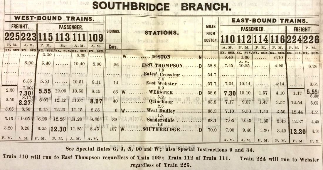
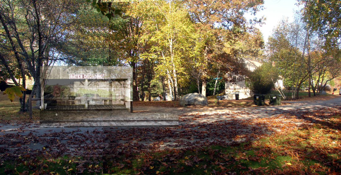
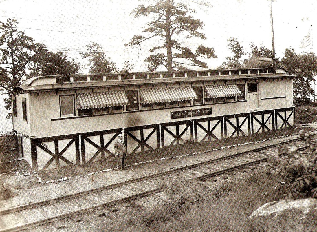
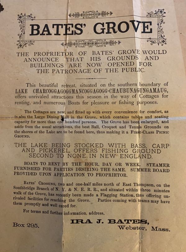
This stop in the town of Thompson was on the Southbridge Branch about two miles from EAST THOMPSON, not in Massachusetts as Karr says but just below the Connecticut border. A June, 1883 Worcester Daily Spy article said that the NY&NE was being petitioned "to make Bates grove at the lake a flag station during the summer season" and that "Mr. Ira Bates has been informed by the railroad authorities if inducement is offered they will stop passenger trains at that point. Mr. Bates will erect a house for convenience near the track." Although not common, the creation of such vacation-resort railroad stops was not without precedent: see PEPPER CROSSING in Monroe. The undated advertising sheet at [7] says that BATES CROSSING ... " has recently been made a Flagging (sic) station..." so it is presumably ca. 1883. The photo at [1] is Lewis H. Benton #821, likely taken on 10/11/1915. It shows the "house" that Bates built at which by August, 1883 the paper said that "all trains stop either to land or take passengers." The grove, operated by him and his family, is seen nearby on the map at [2] with the station structure standing in the southeast quadrant at the grade crossing. The first timetable we have showing this stop is 7/3/1887 with no scheduled stops, but perhaps the trains were flaggable. The 7/27/1890 timetable snippet at [3] shows this as a stop for June through October trains, from which point cottagers and vacationers could easily reach the several facilities that had grown up around Webster Lake over the years. A June, 1902 article tells us that Civil War veteran Albert F. Sheldon will be managing "the lake resort as Bates' Grove this season" and that a July 4 opening with music, dancing and a clambake was planned. The Track 11 GE map snippet at [4] shows the location and Al Weaver's 'ghost station' image on today's Bates Grove Rd. is seen at [5]. Another Albert "Bert" Sheldon, possibly the son, shows up hereabouts as NYNH&H road foreman of engines in the 1920s and 1930s. The photo at [6] shows Clear Block Camp, the lakeside residence just to the north which he created from an old coach moved here ca. 1925. Fran Donovan's 1991 Shoreliner reminiscence says it was still in place then and word is that today it is enclosed within a larger residential structure. Our 9/6/1926 Lines East timetable still shows BATES CROSSING as a stop. Southbridge Branch passenger service ended on 8/15/1930. Trackage from East Thompson to Webster was abandoned in 1937. [REFS: WDS/07/28/1881/04; WDS/06/12/1883/04; WDS/08/14/1883/04; WDS/06/22/1902/08; WDS/07/29/1902/04; SR/07/31/1930/03; SR/10/12/1930/16; HC/08/24/1937/02; K110; SL12.2.6 (1981); SL21.3.6 (1990); SL22.1.4 (1991)][rev121216, 080319]
This stop in the town of Thompson was on the Southbridge Branch about two miles from EAST THOMPSON, not in Massachusetts as Karr says but just below the Connecticut border. A June, 1883 Worcester Daily Spy article said that the NY&NE was being petitioned "to make Bates grove at the lake a flag station during the summer season" and that "Mr. Ira Bates has been informed by the railroad authorities if inducement is offered they will stop passenger trains at that point. Mr. Bates will erect a house for convenience near the track." Although not common, the creation of such vacation-resort railroad stops was not without precedent: see PEPPER CROSSING in Monroe. The undated advertising sheet at [7] says that BATES CROSSING ... " has recently been made a Flagging (sic) station..." so it is presumably ca. 1883. The photo at [1] is Lewis H. Benton #821, likely taken on 10/11/1915. It shows the "house" that Bates built at which by August, 1883 the paper said that "all trains stop either to land or take passengers." The grove, operated by him and his family, is seen nearby on the map at [2] with the station structure standing in the southeast quadrant at the grade crossing. The first timetable we have showing this stop is 7/3/1887 with no scheduled stops, but perhaps the trains were flaggable. The 7/27/1890 timetable snippet at [3] shows this as a stop for June through October trains, from which point cottagers and vacationers could easily reach the several facilities that had grown up around Webster Lake over the years. A June, 1902 article tells us that Civil War veteran Albert F. Sheldon will be managing "the lake resort as Bates' Grove this season" and that a July 4 opening with music, dancing and a clambake was planned. The Track 11 GE map snippet at [4] shows the location and Al Weaver's 'ghost station' image on today's Bates Grove Rd. is seen at [5]. Another Albert "Bert" Sheldon, possibly the son, shows up hereabouts as NYNH&H road foreman of engines in the 1920s and 1930s. The photo at [6] shows Clear Block Camp, the lakeside residence just to the north which he created from an old coach moved here ca. 1925. Fran Donovan's 1991 Shoreliner reminiscence says it was still in place then and word is that today it is enclosed within a larger residential structure. Our 9/6/1926 Lines East timetable still shows BATES CROSSING as a stop. Southbridge Branch passenger service ended on 8/15/1930. Trackage from East Thompson to Webster was abandoned in 1937. [REFS: WDS/07/28/1881/04; WDS/06/12/1883/04; WDS/08/14/1883/04; WDS/06/22/1902/08; WDS/07/29/1902/04; SR/07/31/1930/03; SR/10/12/1930/16; HC/08/24/1937/02; K110; SL12.2.6 (1981); SL21.3.6 (1990); SL22.1.4 (1991)][rev121216, 080319]
Dave Peters Collection
|
|
|
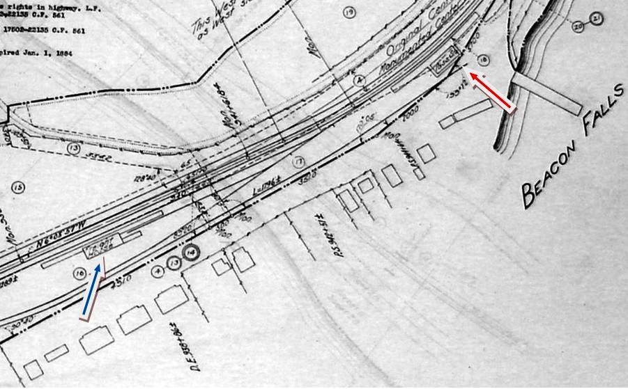
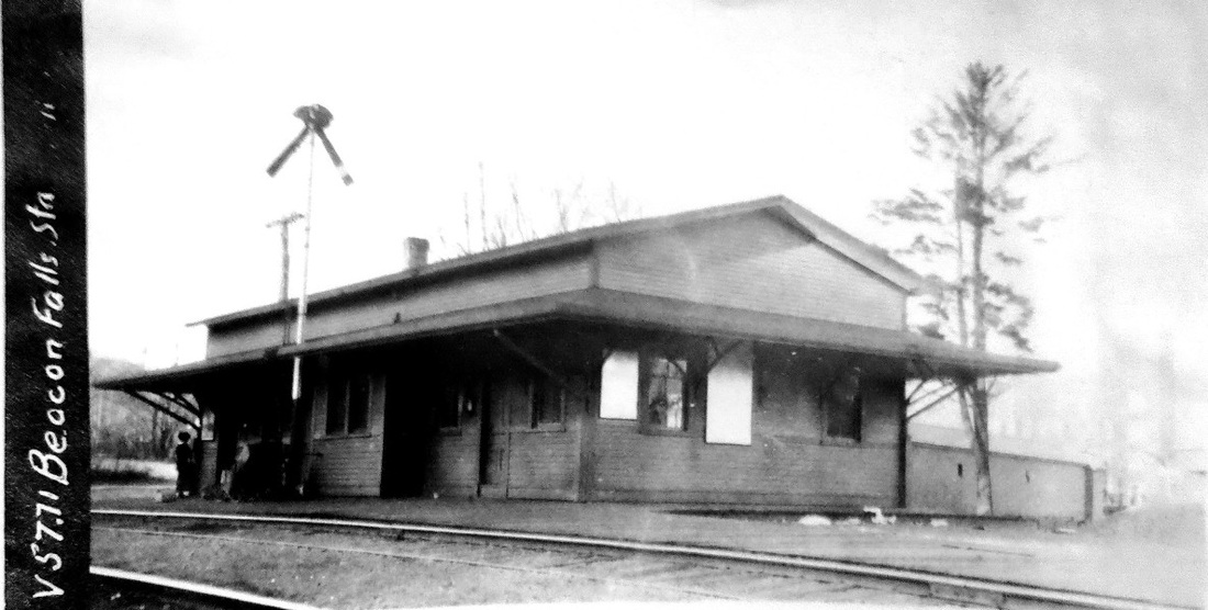
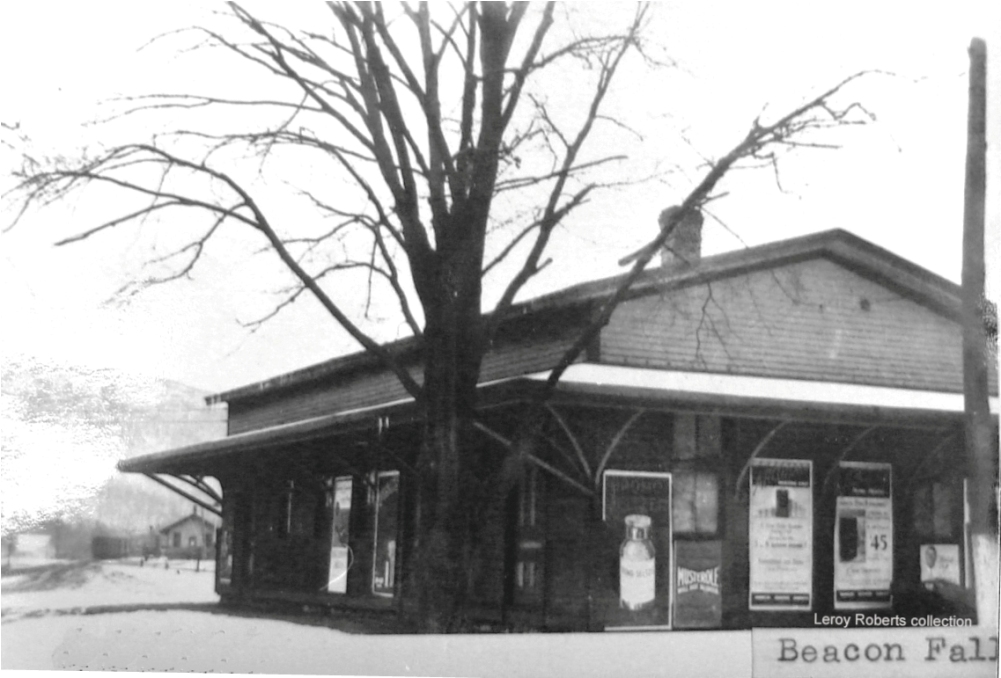
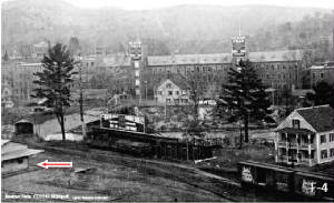
BEACON FALLS1 [NRR, c1855]
This does not appear to have been an original station on the NRR. It is not listed on the 7/4/1849 'Grand Excursion' poster, though even the minor stop at BALDWINS is shown there, and it also is not seen on an 1851TT. It does show up on an 1858TT and was probably established in the interim as a flag stop. Rockey says the NRR opened a "regular station" with Julius A. Hart becoming the agent on 12/21/1868 and remaining so even as Rockey's History of New Haven County was being published in 1892. The expansive depot in the photos is the only one we have ever seen for this stop, and it may not have been the first here. Since all the photos of this structure are later ones, they most certainly reflect the remodeling the railroad commissioners reported in 1899. The val photo at [1] is probably from 1916 and the undated shot at [2] has the freight depot, also from 1899, in the distance. The red arrow in the panorama at [3] points to the corner of the passenger station which was located right where the half covered/half elliptical truss bridge carries Depot St. over the river from the main part of the village. East of the passenger depot is a stub-ended siding and another freight facility, probably owned by the Beacon Falls Rubber Shoe Co. which started operating the factory complex in the distance in 1898. The 1915 val map at [4] shows the passenger station at the red arrow and the freight house at the blue arrow. A list of NYNH&H buildings shows the passenger station being sold on 9/8/1940 to Alex Szozzeine for $150. Its fate thereafter is unknown to us. [REFS: CRC47.1899.29; C92; R2.621][rev121816]
This does not appear to have been an original station on the NRR. It is not listed on the 7/4/1849 'Grand Excursion' poster, though even the minor stop at BALDWINS is shown there, and it also is not seen on an 1851TT. It does show up on an 1858TT and was probably established in the interim as a flag stop. Rockey says the NRR opened a "regular station" with Julius A. Hart becoming the agent on 12/21/1868 and remaining so even as Rockey's History of New Haven County was being published in 1892. The expansive depot in the photos is the only one we have ever seen for this stop, and it may not have been the first here. Since all the photos of this structure are later ones, they most certainly reflect the remodeling the railroad commissioners reported in 1899. The val photo at [1] is probably from 1916 and the undated shot at [2] has the freight depot, also from 1899, in the distance. The red arrow in the panorama at [3] points to the corner of the passenger station which was located right where the half covered/half elliptical truss bridge carries Depot St. over the river from the main part of the village. East of the passenger depot is a stub-ended siding and another freight facility, probably owned by the Beacon Falls Rubber Shoe Co. which started operating the factory complex in the distance in 1898. The 1915 val map at [4] shows the passenger station at the red arrow and the freight house at the blue arrow. A list of NYNH&H buildings shows the passenger station being sold on 9/8/1940 to Alex Szozzeine for $150. Its fate thereafter is unknown to us. [REFS: CRC47.1899.29; C92; R2.621][rev121816]

|
|
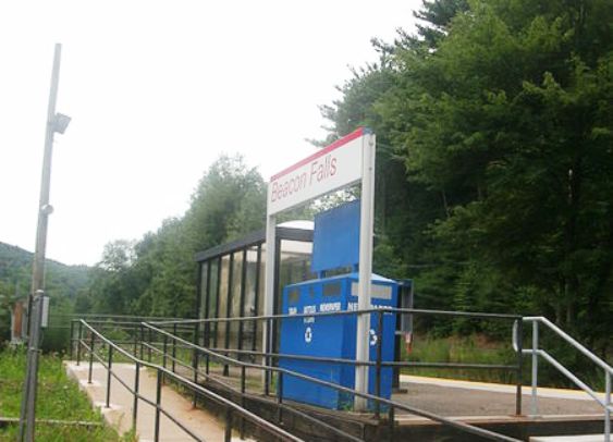
BEACON FALLS2 [MN, 2000?]
Current Metro-North station, a little south of the earlier passenger depot.
Current Metro-North station, a little south of the earlier passenger depot.
|
|

|
|
|
Max Miller Collection
|
BECKLEYS [MRR, 1850]
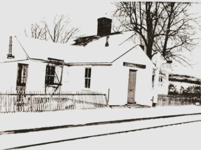
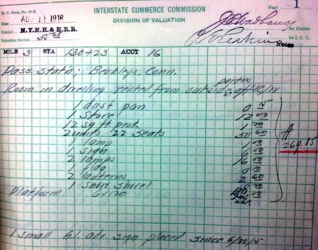
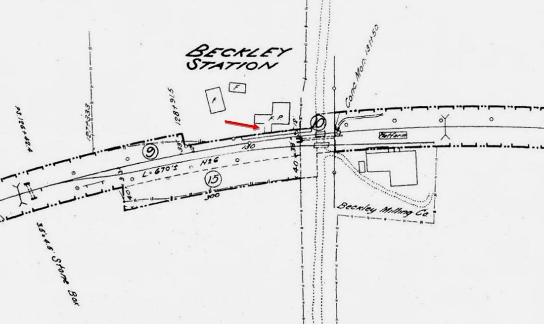
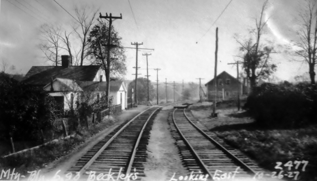
This was an original station on the Middletown RR in the section of BERLIN known as Beckley Quarter, named for a prominent local family. Rail service began on 3/8/1850 and there are few mentions over the years of this stop. The first mention we have come across is in the Courant which reported a man being killed by a train "... west of the Beckley station... on the tressel bridge" in 1853. The house pictured here is the only station we have ever seen, the 'depot' being a in what looks like an addition extending out to the track on the west side of the main house. This was a "room in dwelling rented from outside parties," according to the ICC notes, was not uncommon on early railroads looking to save the expense of putting up structures. Timetables in the 1890s and early 1900s list this as a flag stop. Passenger service lasted through 1930, when the PUC allowed motor buses to take over for some of the trains, which by then were "gas-electric coaches" running between New Britain, Berlin, and Middletown. Interestingly, the buses, which paralleled the railroad right of way, were to make all the stops the trains did, except for BECKLEYS. We are not sure why that was, since it is implied that trains were still stopping here. The map at [1] is from 1869 and our red arrow shows the station in the northwest quadrant of the grade crossing. The paddle is down at [2] for passengers waiting in the snowy scene at [2]. The undated image at [3] looks northwesterly. The 8/11/1916 ICC notes at [4] say there was seating for 22 persons. Total worth of the railroad property here was $269.85, mostly for the value of the platform, but the examiners did not miss the 15-cent dust pan either! Our red arrow on the 1915 val map at [5] points to the station wing. The 10/26/1927 PUC photo at [6] looks east at the station on the left and the Beckley Milling Co. on the right. John Roy reported in 1997 the residence/depot was in sad shape and there was only an empty lot when he returned on 12/28/2001. See EAST BERLIN, NEWFIELD and WESTFIELD for other stops on the nine-mile long MRR. [REFS: HDC/05/14/1853/02; HC/07/15/1890/06; HC/09/01/1891/06; HC/07/07/1930/02; TTS: 1894, 1907, 1911, 1923; K74; R306][rev121716]
This was an original station on the Middletown RR in the section of BERLIN known as Beckley Quarter, named for a prominent local family. Rail service began on 3/8/1850 and there are few mentions over the years of this stop. The first mention we have come across is in the Courant which reported a man being killed by a train "... west of the Beckley station... on the tressel bridge" in 1853. The house pictured here is the only station we have ever seen, the 'depot' being a in what looks like an addition extending out to the track on the west side of the main house. This was a "room in dwelling rented from outside parties," according to the ICC notes, was not uncommon on early railroads looking to save the expense of putting up structures. Timetables in the 1890s and early 1900s list this as a flag stop. Passenger service lasted through 1930, when the PUC allowed motor buses to take over for some of the trains, which by then were "gas-electric coaches" running between New Britain, Berlin, and Middletown. Interestingly, the buses, which paralleled the railroad right of way, were to make all the stops the trains did, except for BECKLEYS. We are not sure why that was, since it is implied that trains were still stopping here. The map at [1] is from 1869 and our red arrow shows the station in the northwest quadrant of the grade crossing. The paddle is down at [2] for passengers waiting in the snowy scene at [2]. The undated image at [3] looks northwesterly. The 8/11/1916 ICC notes at [4] say there was seating for 22 persons. Total worth of the railroad property here was $269.85, mostly for the value of the platform, but the examiners did not miss the 15-cent dust pan either! Our red arrow on the 1915 val map at [5] points to the station wing. The 10/26/1927 PUC photo at [6] looks east at the station on the left and the Beckley Milling Co. on the right. John Roy reported in 1997 the residence/depot was in sad shape and there was only an empty lot when he returned on 12/28/2001. See EAST BERLIN, NEWFIELD and WESTFIELD for other stops on the nine-mile long MRR. [REFS: HDC/05/14/1853/02; HC/07/15/1890/06; HC/09/01/1891/06; HC/07/07/1930/02; TTS: 1894, 1907, 1911, 1923; K74; R306][rev121716]
BEERS MILL [> LONG HILL]
BEERS STATION [> RIDGEFIELD1]
BEE STREET [> EAST MERIDEN2]
BELAMOSE [> DIVIDEND]
BELLE DOCK [> NEW HAVEN1]
BELLE DOCK JUNCTION [> MILL RIVER JUNCTION]
BEERS STATION [> RIDGEFIELD1]
BEE STREET [> EAST MERIDEN2]
BELAMOSE [> DIVIDEND]
BELLE DOCK [> NEW HAVEN1]
BELLE DOCK JUNCTION [> MILL RIVER JUNCTION]
|

|
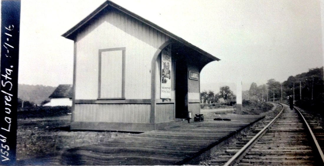
BENVENUE [NYNH&H, 1904]
This stop was created for William A. Engeman's Benvenue Granite Co. quarry that flourished from ca. 1897 to 1908. The Courant said in May, 1904 that "Benvenue, a small settlement in the southern part of Middletown, is enjoying a decided boom. The railroad company is erecting a station which it promised some time ago. A shed to accommodate 100 stone cutters will soon be finished, and two air plants are being put in. Beside this six new cottages are being erected and there are calls for twelve more." The station looks like a standard NYNH&H shelter of the era and it was located about two miles north of MAROMAS. The BENVENUE stop is seen on the 1907 and 1911TTs and on the RAM maps from 1910 until 1926, even though the name was changed to LAUREL, perhaps as early as 1910. The 1,000-acre quarry operation employed as many as 500 men at its height and had its own five-mile railroad with switchbacks up the steep slope, two locomotives and a roundhouse. The 'granite railroad' could deliver product to boats at the quarry's river dock or could load it into NYNH&H cars for rail shipment via the Valley branch. The Courant reported in 1902 that there was an "an inexhaustible supply of blue gray granite of unusual strength" here but in 1908 said that the company was dismantling its equipment and sending it to Maine where it had another quarry. A 1912 article reported that the supply had run out suddenly and that activity had ceased four years earlier. Another chapter in the life of this station would come with its renaming as LAUREL. A new owner from New York so named the property for the profusion of the shrub in the area and began renting out the old cabins to tourists who came by trains that stopped here in the summer only. By 1915 the Interstate Feature Film Co. of New York was said to have purchased the old Benvenue property with the intention of using the rocky terrain for making movies. Famed actors Hamilton Crane and Sydney Shields were soon shooting The Brand of Shinto, an action film set in the Canadian Rockies that included a scene with Ms. Shields, a la Lillian Gish, crossing the Connecticut River on thin winter ice. We don't think this film made it to the big screen and we are not sure how long this Hollywood in Middletown lasted, but LAUREL remained a flag stop at least until 1923. Passenger service ended on the Valley branch ca. 1933. The 1938 SSRR list says the shelter shed was razed on 5/15/1938. [REFS: SR/01/14/1895/07; HC/08/05/1897/11; NHER/12/07/1899/05; HC/08/02/1902/12; HC/05/30/1904/17; HC/07/14/1904/14; 1907TT; HC/03/07/1908/17; 1911TT; HC/08/02/1912/12; HC/08/30/1912/12; HC/08/13/1914/15; HC/01/17/1915/X2; 1923TT; HC/07/04/1937/B1; HC/06/14/1953/SM9; K98][rev010317]
This stop was created for William A. Engeman's Benvenue Granite Co. quarry that flourished from ca. 1897 to 1908. The Courant said in May, 1904 that "Benvenue, a small settlement in the southern part of Middletown, is enjoying a decided boom. The railroad company is erecting a station which it promised some time ago. A shed to accommodate 100 stone cutters will soon be finished, and two air plants are being put in. Beside this six new cottages are being erected and there are calls for twelve more." The station looks like a standard NYNH&H shelter of the era and it was located about two miles north of MAROMAS. The BENVENUE stop is seen on the 1907 and 1911TTs and on the RAM maps from 1910 until 1926, even though the name was changed to LAUREL, perhaps as early as 1910. The 1,000-acre quarry operation employed as many as 500 men at its height and had its own five-mile railroad with switchbacks up the steep slope, two locomotives and a roundhouse. The 'granite railroad' could deliver product to boats at the quarry's river dock or could load it into NYNH&H cars for rail shipment via the Valley branch. The Courant reported in 1902 that there was an "an inexhaustible supply of blue gray granite of unusual strength" here but in 1908 said that the company was dismantling its equipment and sending it to Maine where it had another quarry. A 1912 article reported that the supply had run out suddenly and that activity had ceased four years earlier. Another chapter in the life of this station would come with its renaming as LAUREL. A new owner from New York so named the property for the profusion of the shrub in the area and began renting out the old cabins to tourists who came by trains that stopped here in the summer only. By 1915 the Interstate Feature Film Co. of New York was said to have purchased the old Benvenue property with the intention of using the rocky terrain for making movies. Famed actors Hamilton Crane and Sydney Shields were soon shooting The Brand of Shinto, an action film set in the Canadian Rockies that included a scene with Ms. Shields, a la Lillian Gish, crossing the Connecticut River on thin winter ice. We don't think this film made it to the big screen and we are not sure how long this Hollywood in Middletown lasted, but LAUREL remained a flag stop at least until 1923. Passenger service ended on the Valley branch ca. 1933. The 1938 SSRR list says the shelter shed was razed on 5/15/1938. [REFS: SR/01/14/1895/07; HC/08/05/1897/11; NHER/12/07/1899/05; HC/08/02/1902/12; HC/05/30/1904/17; HC/07/14/1904/14; 1907TT; HC/03/07/1908/17; 1911TT; HC/08/02/1912/12; HC/08/30/1912/12; HC/08/13/1914/15; HC/01/17/1915/X2; 1923TT; HC/07/04/1937/B1; HC/06/14/1953/SM9; K98][rev010317]
BERLIN1 [H&NH, 1839]
This was an original stop in the town of the same name on the H&NH when it opened in December, 1839. The first 'ticket office' here was reportedly in a home or general store. This venue served as the station, probably for freight as well as passengers, from December, 1839 until July, 1840. The house is probably the one still standing at 12 Four Rod Rd in the Kensington section of towm. [rev080619, 031323]
This was an original stop in the town of the same name on the H&NH when it opened in December, 1839. The first 'ticket office' here was reportedly in a home or general store. This venue served as the station, probably for freight as well as passengers, from December, 1839 until July, 1840. The house is probably the one still standing at 12 Four Rod Rd in the Kensington section of towm. [rev080619, 031323]
|
|
|
BERLIN2 [H&NH, 1840]
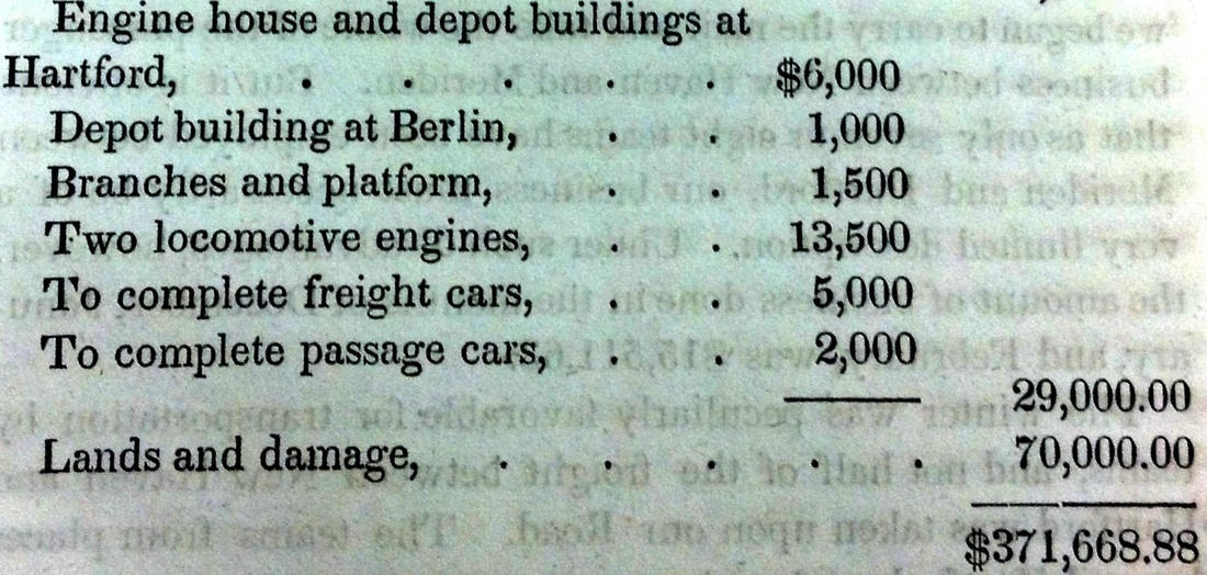
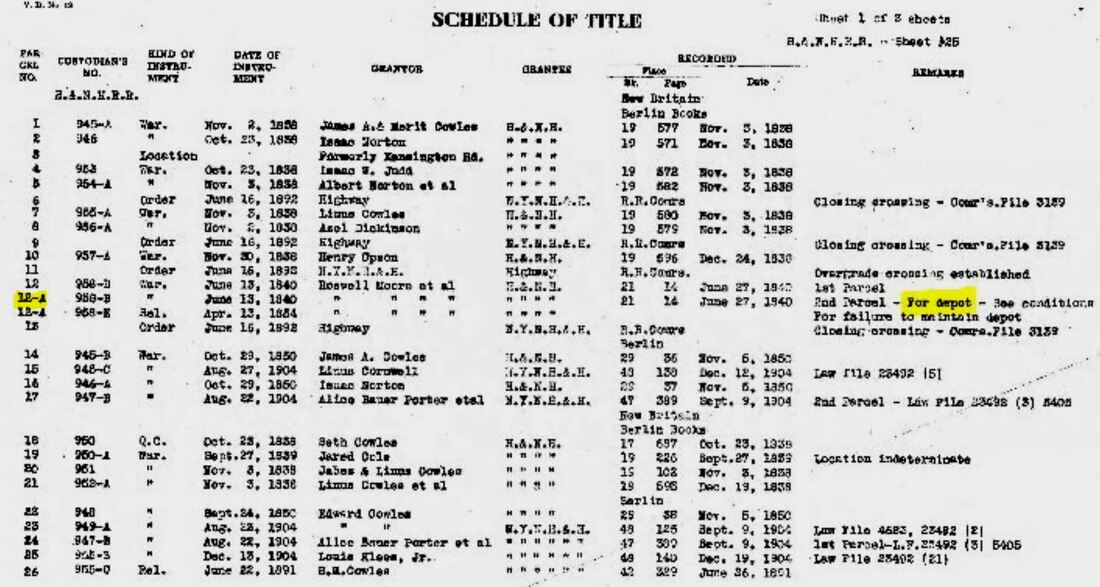
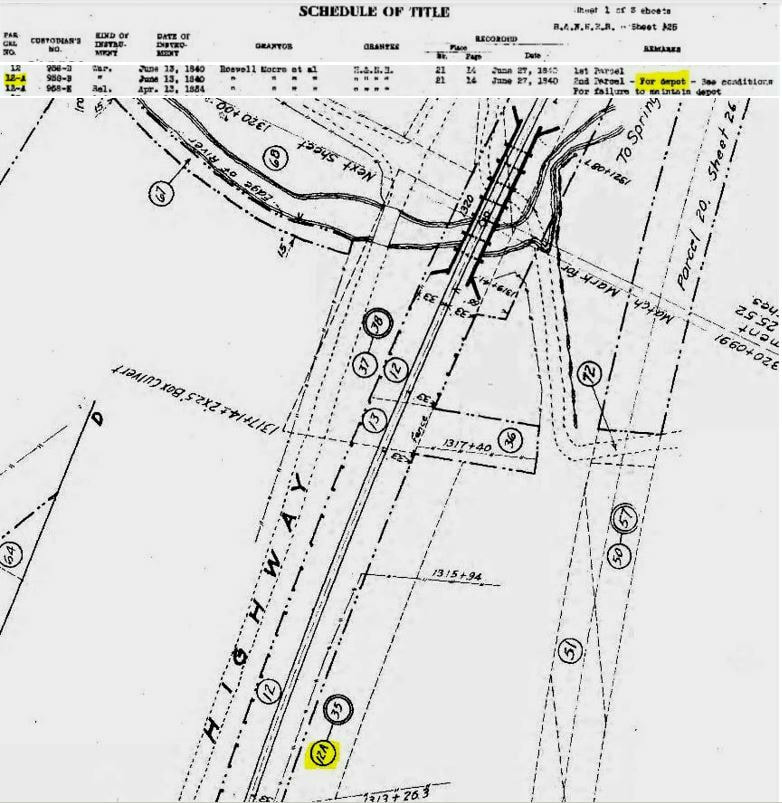
The first purpose-based railroad depot was on two acres of land belonging to Roswell Moore, et al. which was sold for $300 on 6/13/1840. The cost of the depot was $1,000 according to the annual report of 1839, as seen at [1]. It was described as as a 20x60-ft structure, "a one-story, wooden building with a low attic." We have no photograph. A look at the 1915 val map Schedule of Title at [2] has a note, the likes of which we have never seen elsewhere, but for which now we will be on the lookout. Parcel 12-A specifies that this land is "For depot" and even says that there are conditions in the deed in the event that the parcel is not used for such purposes. The val map at [3] shows where parcel 12-A was, thereby placing this second depot about 600 feet south of the Mattabesset River arches at 28 Four Rod Rd. today. The snippet from our Track 11 Google Earth map at [4] shows the location of BERLIN2 as well as all the other station here. [REFS: HNHAR4.1839.5; HNHAR6.1841.5; 1915 valuation map 55.71.25; R33][rev121716, 020519, 022619, 022222]
The first purpose-based railroad depot was on two acres of land belonging to Roswell Moore, et al. which was sold for $300 on 6/13/1840. The cost of the depot was $1,000 according to the annual report of 1839, as seen at [1]. It was described as as a 20x60-ft structure, "a one-story, wooden building with a low attic." We have no photograph. A look at the 1915 val map Schedule of Title at [2] has a note, the likes of which we have never seen elsewhere, but for which now we will be on the lookout. Parcel 12-A specifies that this land is "For depot" and even says that there are conditions in the deed in the event that the parcel is not used for such purposes. The val map at [3] shows where parcel 12-A was, thereby placing this second depot about 600 feet south of the Mattabesset River arches at 28 Four Rod Rd. today. The snippet from our Track 11 Google Earth map at [4] shows the location of BERLIN2 as well as all the other station here. [REFS: HNHAR4.1839.5; HNHAR6.1841.5; 1915 valuation map 55.71.25; R33][rev121716, 020519, 022619, 022222]
|
|
|

BERLIN3 [H&NH, 1848]
The station at [1] appears to be wooden which would make it the 1848 depot that lasted until 1893. Later structures were brick. R&LHS notes say that a Springfield contractor by the name of J.J. Smith made an offer on 4/3/1848 to build a depot here for $1760 and one at Wallingford for $1805, $3550 if he got the contract for both. The H&NH annual report for 1848 at [2] indicates two stations were built, presumably our WALLINGFORD2 and one at the 'NEW BRITAIN' stop, apparently meaning here. Looking at the 1855 HC map at [3], one can see the station on the east side of the track within the full wye connection for the 1850 Middletown RR. At [4] men are gathered at the main entrance to the depot, where the Dutch clock shows the last northbound train passed at 9:03 and the last southbound at 8:48. No newspaper mention of the building of this depot has been found but, with the coming of the next depot in 1893, the removal of this one commenced on 8/13/1893 and "by Tuesday night [8/15] every timber of the old structure was off the grounds. Thanks to the diligent note-taking of railfan and collector Frank Ballard Ramsdell of West Thompson, CT, we know all the names and railroad positions of the men pictured at [4]. From left to right: N.S. Thresher, station agent; Seth Stanley, ticket agent; Ed Thresher, freighthouse man; Ed Gamby, Jim Gamby, Michael Canary, John Cashman, switchmen; Fred ????, station baggagemaster; William Lynch, switchman. A full crew for a busy station! [REFS: HNHAR13.1848.14; HDC/01/28/1850/02; NHJC/08/21/1893/05; B621][rev122816, 011419, 022619, 080619]
The station at [1] appears to be wooden which would make it the 1848 depot that lasted until 1893. Later structures were brick. R&LHS notes say that a Springfield contractor by the name of J.J. Smith made an offer on 4/3/1848 to build a depot here for $1760 and one at Wallingford for $1805, $3550 if he got the contract for both. The H&NH annual report for 1848 at [2] indicates two stations were built, presumably our WALLINGFORD2 and one at the 'NEW BRITAIN' stop, apparently meaning here. Looking at the 1855 HC map at [3], one can see the station on the east side of the track within the full wye connection for the 1850 Middletown RR. At [4] men are gathered at the main entrance to the depot, where the Dutch clock shows the last northbound train passed at 9:03 and the last southbound at 8:48. No newspaper mention of the building of this depot has been found but, with the coming of the next depot in 1893, the removal of this one commenced on 8/13/1893 and "by Tuesday night [8/15] every timber of the old structure was off the grounds. Thanks to the diligent note-taking of railfan and collector Frank Ballard Ramsdell of West Thompson, CT, we know all the names and railroad positions of the men pictured at [4]. From left to right: N.S. Thresher, station agent; Seth Stanley, ticket agent; Ed Thresher, freighthouse man; Ed Gamby, Jim Gamby, Michael Canary, John Cashman, switchmen; Fred ????, station baggagemaster; William Lynch, switchman. A full crew for a busy station! [REFS: HNHAR13.1848.14; HDC/01/28/1850/02; NHJC/08/21/1893/05; B621][rev122816, 011419, 022619, 080619]

Copyright NHRHTA
|
Copyright NHRHTA
|

Copyright NHRHTA
|
|
|
|
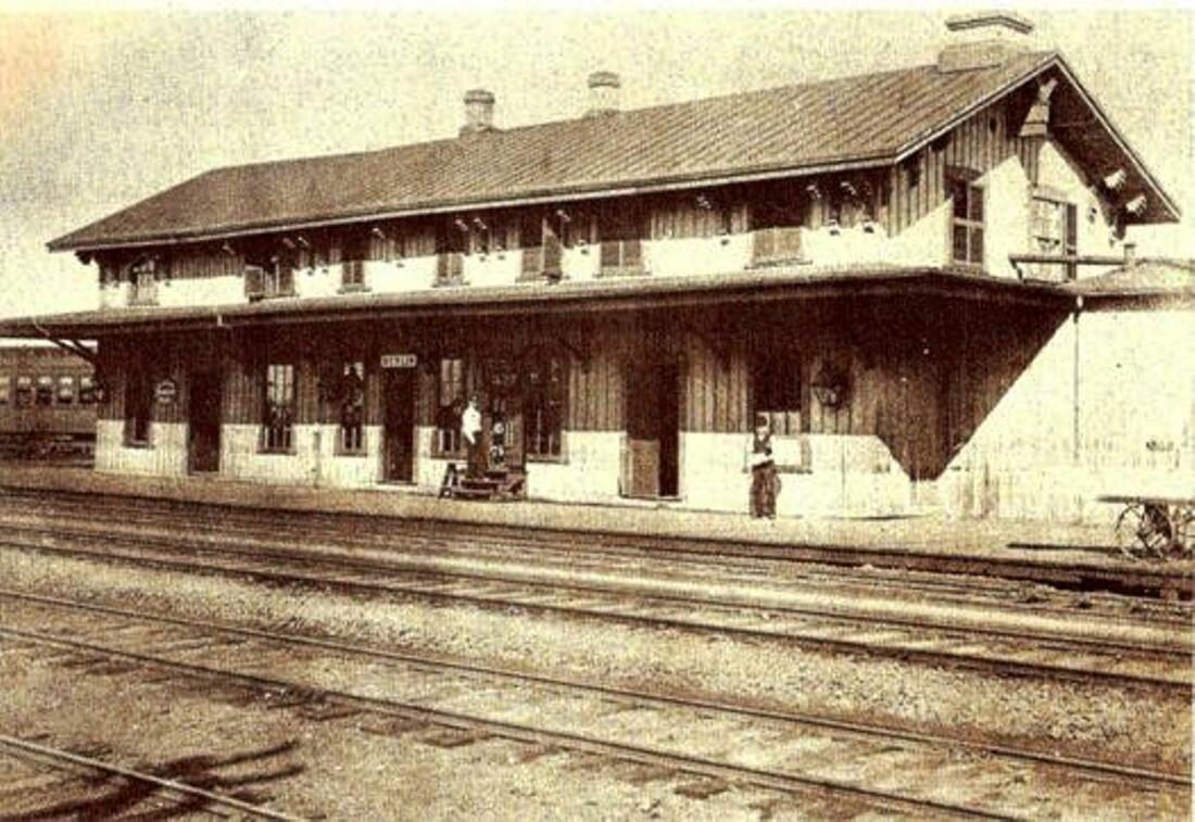
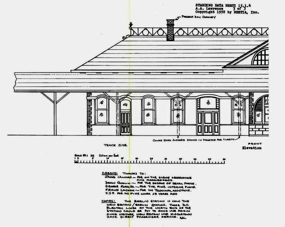
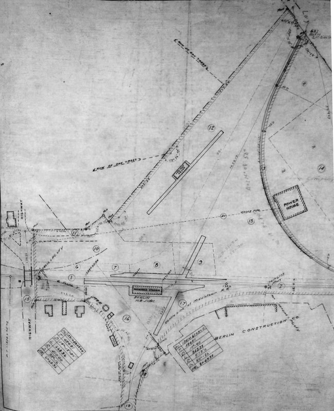
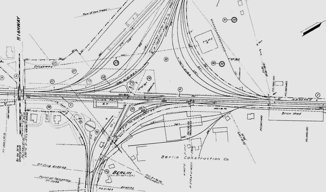
BERLIN4 [NYNH&H, 1893]
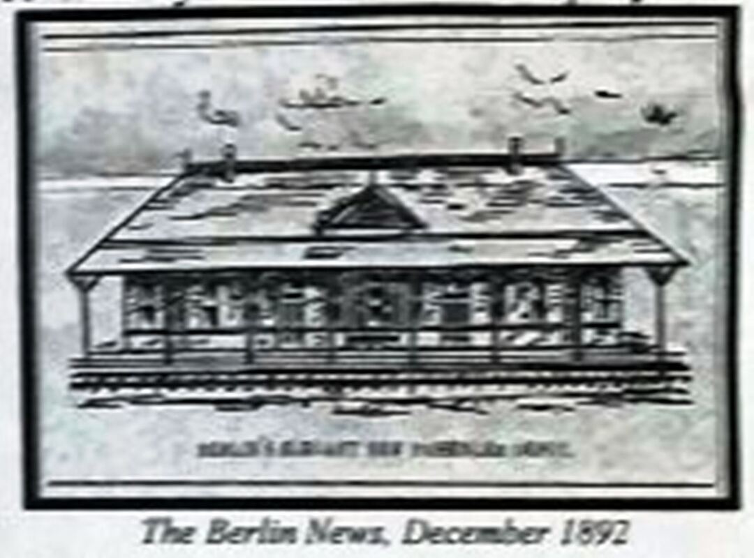
According to the Waterbury Evening Democrat, the first indication of a new depot coming here was occasioned by a visit from Vice President E.M. Reed on 1/15/1891. The Stamford Daily Advocate said the Consolidated was spending $75,000 on improvements here. Later we learn that they included a new 55-foot turntable, new 55,000-gallon water tank, new tank-house and pumping engine and the elimination of four grade crossings. The plans at [1]-[3], are dated October, 1892. The muddy December, 1892 newspaper sketch at [4] anticipates the new station. Erected just south of BERLIN3, station was to have opened by April, 1893 but in fact it did not until the middle of August, 1893, with Journal-Courier of 8/21/1893 saying it "was occupied by the company for the first time last week. It also remarked that the 40x80-ft structure was in the style of "the standard depot erected on the different lines of the Consolidated." In fact, this hip-roofed style was replicated in Norwich, Norwalk, Seymour, Stamford, and Torrington and we think the new design was really the first that the NYNH&H created for itself after inheriting depots that originated from its predecessors in varying styles. The railroad commissioners praised the 1893 changes here with the "capacious and pleasant waiting room" and sheltered platforms. The valuable photo at lower right appears to show the removal of the earlier diamonds which, In the commissioners' words of December, 1895, the Middletown and New Britain branches had been "united and extended" as "one continuous line" across the tracks of the Hartford Division. The commissioners express their hope that precaution would be taken that would "render a collision at this point physically impossible," acknowledging that, though less likely on branches of the same railroad, such an event was still possible. The superior quality clay of the new Yale Brick Co., which had 13 adjacent acres of land eastward of the railroad tracks, was the raw material for the exterior facing of the new station. The NYNH&H chose yellow from the offering "of any desired color" for the 150,000 bricks it needed. This depot burned on 2/27/1896 after "one of the automatic lights in the baggage room exploded, it is thought by many." [REFS: WED/01/17/1891/05; SAD/11/01/1891/04; NHER/08/13/1892/04; NHER/10/01/1892/01; HC/12/10/1892/19; CRC40.1892.19; NHJC/04/08/1893/04; NHER/06/10/1893/03; NHJC/08/21/1893/05; HC/08/24/1893/08; HC/02/27/189600 CRC41.1893.18; CRC43.1895.13; R34][rev122816, 022619]
According to the Waterbury Evening Democrat, the first indication of a new depot coming here was occasioned by a visit from Vice President E.M. Reed on 1/15/1891. The Stamford Daily Advocate said the Consolidated was spending $75,000 on improvements here. Later we learn that they included a new 55-foot turntable, new 55,000-gallon water tank, new tank-house and pumping engine and the elimination of four grade crossings. The plans at [1]-[3], are dated October, 1892. The muddy December, 1892 newspaper sketch at [4] anticipates the new station. Erected just south of BERLIN3, station was to have opened by April, 1893 but in fact it did not until the middle of August, 1893, with Journal-Courier of 8/21/1893 saying it "was occupied by the company for the first time last week. It also remarked that the 40x80-ft structure was in the style of "the standard depot erected on the different lines of the Consolidated." In fact, this hip-roofed style was replicated in Norwich, Norwalk, Seymour, Stamford, and Torrington and we think the new design was really the first that the NYNH&H created for itself after inheriting depots that originated from its predecessors in varying styles. The railroad commissioners praised the 1893 changes here with the "capacious and pleasant waiting room" and sheltered platforms. The valuable photo at lower right appears to show the removal of the earlier diamonds which, In the commissioners' words of December, 1895, the Middletown and New Britain branches had been "united and extended" as "one continuous line" across the tracks of the Hartford Division. The commissioners express their hope that precaution would be taken that would "render a collision at this point physically impossible," acknowledging that, though less likely on branches of the same railroad, such an event was still possible. The superior quality clay of the new Yale Brick Co., which had 13 adjacent acres of land eastward of the railroad tracks, was the raw material for the exterior facing of the new station. The NYNH&H chose yellow from the offering "of any desired color" for the 150,000 bricks it needed. This depot burned on 2/27/1896 after "one of the automatic lights in the baggage room exploded, it is thought by many." [REFS: WED/01/17/1891/05; SAD/11/01/1891/04; NHER/08/13/1892/04; NHER/10/01/1892/01; HC/12/10/1892/19; CRC40.1892.19; NHJC/04/08/1893/04; NHER/06/10/1893/03; NHJC/08/21/1893/05; HC/08/24/1893/08; HC/02/27/189600 CRC41.1893.18; CRC43.1895.13; R34][rev122816, 022619]
|
|
|
BERLIN5 [NYNH&H, 1896]
This station was built of red brick in a design very similar to both its predecessor and successor, a fact that makes it difficult to distinguish between them. This one opened in August of 1896. Struck by lightning, it burned on 6/27/1900. While postcards like the one at upper left are not always colorized accurately, we would have a genuine image of BERLIN4 if this one is correct. What may also be a fortuitously captured clue, however, is that the track that joined the two branches as one continuous line is now severed, according to the Courant as of May, 1900, because the diamond necessitated the slowing of main line express trains and it was not used much after third rail electrification was introduced and did not extend from here to Middletown. Electric service to that city was reported to be in operation in the June, 1907 NYNH&H annual report and used the overhead trolley system with cars like the one pictured at [2]. The card also shows the curved canopy for the New Britain line to the far right and the west end of the one for the Middletown trains in the extreme left. The photo at [3] shows the hefty Col. N.H. Heft, chief engineer of the electrification project, at the controls of a third-rail car pointed toward New Britain in 1899, with the Middletown crossover apparently in place beyond the right side of the car. To the car's left, one can see the factory of the Yale Brick Co. that supplied the building material for BERLIN3. Third-rail service began on 5/27/1897 both from here and from Hartford to the Hardware City and was further extended to Bristol in 1898. It lasted until 7/7/1906 when the city of New Britain got an injunction against its use there because of the numerous electrocutions. Thereafter, the entire third-rail operation was curtailed and service replaced by small smoky steamers called dinky engines. The map at [4] dates to 1910; note the reference to this stop as New Britain Jct. [REFS: CRC44.1896.17; HC/08/07/1896/09; HC/08/24/1896/06; HC/05/27/1897/08; HC/05/07/1900/09; NHJC/0703/1900/02; HC/07/28/1900/05; HC/06/30/1906/10; NHAR36.1907.7; HC/10/03/1907/11; HC/11/03/1910/05; NL23.1.2; SL15.1.6; R33][rev112018]
This station was built of red brick in a design very similar to both its predecessor and successor, a fact that makes it difficult to distinguish between them. This one opened in August of 1896. Struck by lightning, it burned on 6/27/1900. While postcards like the one at upper left are not always colorized accurately, we would have a genuine image of BERLIN4 if this one is correct. What may also be a fortuitously captured clue, however, is that the track that joined the two branches as one continuous line is now severed, according to the Courant as of May, 1900, because the diamond necessitated the slowing of main line express trains and it was not used much after third rail electrification was introduced and did not extend from here to Middletown. Electric service to that city was reported to be in operation in the June, 1907 NYNH&H annual report and used the overhead trolley system with cars like the one pictured at [2]. The card also shows the curved canopy for the New Britain line to the far right and the west end of the one for the Middletown trains in the extreme left. The photo at [3] shows the hefty Col. N.H. Heft, chief engineer of the electrification project, at the controls of a third-rail car pointed toward New Britain in 1899, with the Middletown crossover apparently in place beyond the right side of the car. To the car's left, one can see the factory of the Yale Brick Co. that supplied the building material for BERLIN3. Third-rail service began on 5/27/1897 both from here and from Hartford to the Hardware City and was further extended to Bristol in 1898. It lasted until 7/7/1906 when the city of New Britain got an injunction against its use there because of the numerous electrocutions. Thereafter, the entire third-rail operation was curtailed and service replaced by small smoky steamers called dinky engines. The map at [4] dates to 1910; note the reference to this stop as New Britain Jct. [REFS: CRC44.1896.17; HC/08/07/1896/09; HC/08/24/1896/06; HC/05/27/1897/08; HC/05/07/1900/09; NHJC/0703/1900/02; HC/07/28/1900/05; HC/06/30/1906/10; NHAR36.1907.7; HC/10/03/1907/11; HC/11/03/1910/05; NL23.1.2; SL15.1.6; R33][rev112018]

|

|
|
|
Peck Library, Berlin
|
|
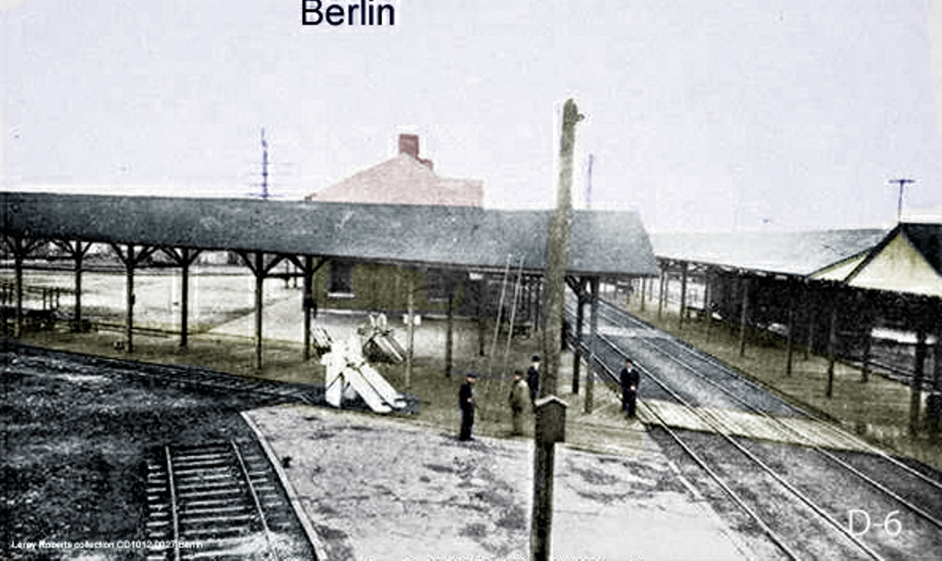
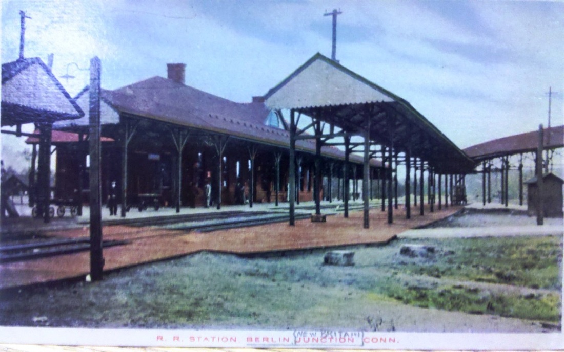
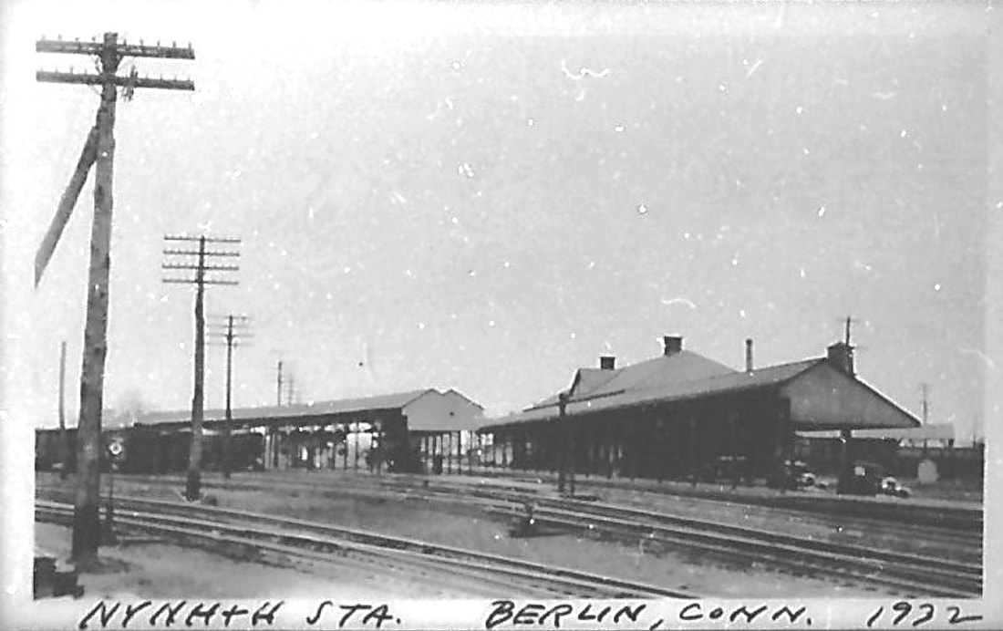
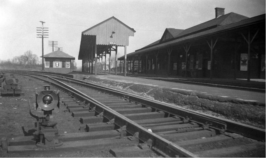
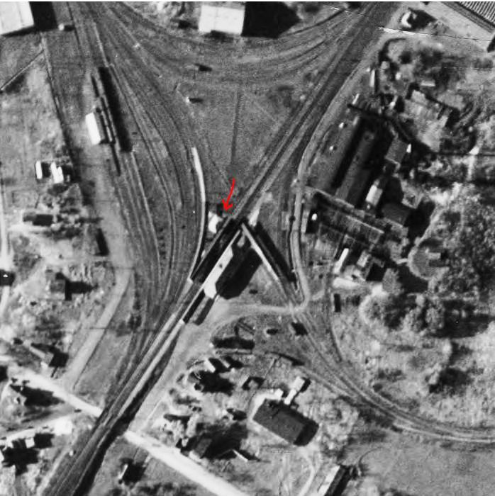
BERLIN6 [NYNH&H, 1900]
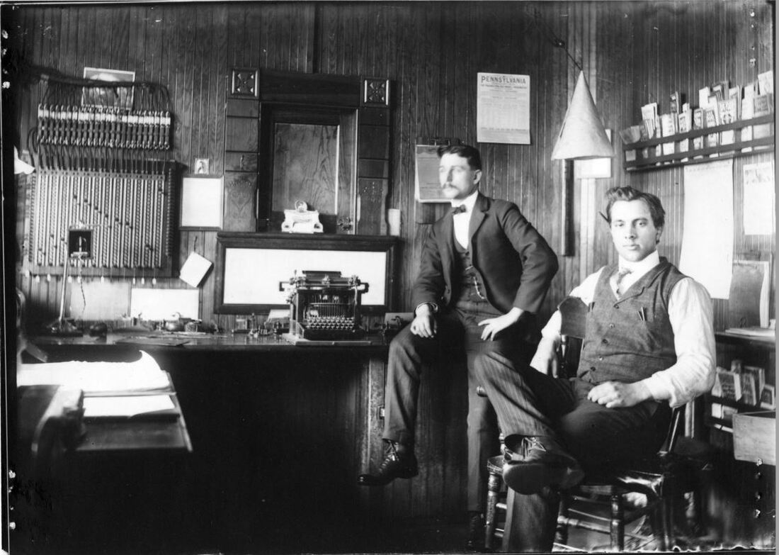
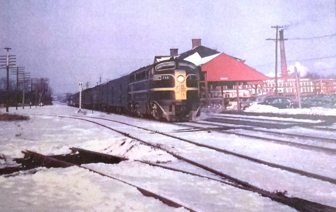
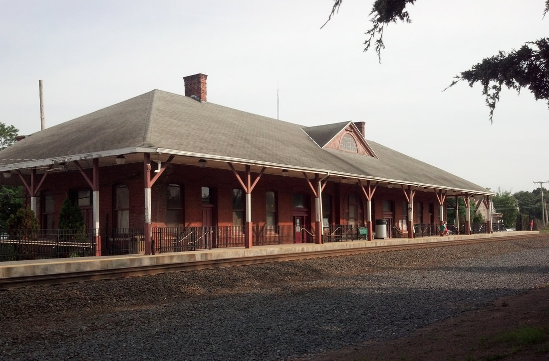
Since the ICC valuation photos are dated 1916 and 1917, we can be sure they show the station that opened in December, 1900. According to 'Berlin Bill' Sample, the old foundation was reused for the new structure. An article in the Register says "the walls of the old station [BERLIN4] remain in good condition and will be utilized... the new station will not differ from the old one in any important particular." The image at [1] looks northwest at the street side of the station; utilitarian porte cochere at the entrance is seen along with the covershed for the Middletown cars in the background to the north. The shot at [2] shows looks southeast. The old diamond was just above the planked walk across the tracks. The 1932 photo at [3] looks north, with the yard and line to New Britain curving off to the west. The handwriting looks like Irving Drake's; was Lewis H. Benton here also taking his own photos, yet undiscovered? The valuation map snippet at [4] shows this important junction in 1915. Interior shots of depots are rare but the fabulous period photo at [5] shows what it looked ca. 1900, with railroad personnel, no less. The shot at [6] is probably from the 1960s with a southbound train passing the station. We got the great shot at [7] on 6/22/2013. BERLIN6 served Amtrak until recently when construction of BERLIN8 was underway. The old depot, with its beautifully restored interior, was in the process of being renovated as a community center when it was gutted by fire on 12/21/2016. The 1896 walls survived the flame once again but have been torn down with only a few artifacts retrieved. No responsibility for the cause has yet been determined. There is some talk of rebuilding a facsimile for a museum and community center as was planned before the fire. [REFS: NHER/07/11/1900/01; CRC48.1900.21][rev112918, 080619]
Since the ICC valuation photos are dated 1916 and 1917, we can be sure they show the station that opened in December, 1900. According to 'Berlin Bill' Sample, the old foundation was reused for the new structure. An article in the Register says "the walls of the old station [BERLIN4] remain in good condition and will be utilized... the new station will not differ from the old one in any important particular." The image at [1] looks northwest at the street side of the station; utilitarian porte cochere at the entrance is seen along with the covershed for the Middletown cars in the background to the north. The shot at [2] shows looks southeast. The old diamond was just above the planked walk across the tracks. The 1932 photo at [3] looks north, with the yard and line to New Britain curving off to the west. The handwriting looks like Irving Drake's; was Lewis H. Benton here also taking his own photos, yet undiscovered? The valuation map snippet at [4] shows this important junction in 1915. Interior shots of depots are rare but the fabulous period photo at [5] shows what it looked ca. 1900, with railroad personnel, no less. The shot at [6] is probably from the 1960s with a southbound train passing the station. We got the great shot at [7] on 6/22/2013. BERLIN6 served Amtrak until recently when construction of BERLIN8 was underway. The old depot, with its beautifully restored interior, was in the process of being renovated as a community center when it was gutted by fire on 12/21/2016. The 1896 walls survived the flame once again but have been torn down with only a few artifacts retrieved. No responsibility for the cause has yet been determined. There is some talk of rebuilding a facsimile for a museum and community center as was planned before the fire. [REFS: NHER/07/11/1900/01; CRC48.1900.21][rev112918, 080619]
|

|
|
BERLIN7 [NYNH&H, c1920]
The photo at [1] shows this building in the distance and the 11/14/1935 val photo at [2] has this structure labeled as the westbound station. It is not seen on the 1916 val map in the previous entry but the 1934 aerial survey shot at [3] appears to show this depot at the red arrow. Located here it would have served passengers going west to New Britain or south to New Haven. [rev121716]
The photo at [1] shows this building in the distance and the 11/14/1935 val photo at [2] has this structure labeled as the westbound station. It is not seen on the 1916 val map in the previous entry but the 1934 aerial survey shot at [3] appears to show this depot at the red arrow. Located here it would have served passengers going west to New Britain or south to New Haven. [rev121716]
 CTDOT
CTDOT
BERLIN8 [CDOT, 2018]
Two high-level platforms connected by an overhead pedestrian bridge opened at the Hartford Line service launch on June 16, 2018. [rev011419]
Two high-level platforms connected by an overhead pedestrian bridge opened at the Hartford Line service launch on June 16, 2018. [rev011419]
|

|
Danbury Historical Society
|
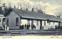
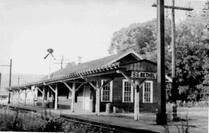
BETHEL1 [D&N, 1852]
The 1879 Bailey map at [1] shows the original station already with the enlargements of 1867 when the newspaper said the D&N had finished an addition to their Danbury freight house and that they had "completed a similar operation" at the station here and "considerably lengthened the platform." A negative in the Ramsdell Transportation Collection dates the scene at [2] to 1889. This is the D&N's first Bethel station, presumably dating to the debut of the railroad in 1852. The 'diamonds and teardrop' bargeboards are virtually identical to the company's DANBURY1 station, seen at [3], and WILTON1 as well. The HRR No. 15 was a 28-ton 1871 Rogers engine named David S. Draper. Here the image defect on the tender looks like a 'cannonball shot' just below the tail end of the name faintly seen. It was customary for railroads here and elsewhere to honor their officials. Director and later vice president, Draper died on 4/3/1885. Richard Fleischer points to the extended smokebox which indicates the late 1880s. Perhaps more telling is the 1890 Connecticut Western News article that reports that the HRR and the CNE&W have changed "... the names we loved so well have disappeared because the locomotives have increased in strength." The paper argues that the old names should have been bretained "... instead of substituting such a vile name as John L. Sullivan" presumably for the noted pugilist. We heartily agree with the sentiment but find no HRR locomotive so named. Perhaps the CWN was being facetious! BETHEL1 burned on 12/15/1898, either by fire from an overheated stove or a spark from a passing locomotive. The Register commented that the fire department was unable to save the structure "which was of wood and very old." It also said that the station was an important one for "it is a changing point for a large number of passengers" transferring to the Shepaug line and that "a temporary office has been located in a baggage car." [REFS: DT/12/05/1867/03; BEF/04/04/1885/00; HDC/04/06/1885/03; CWN/06/11/1890/03; WED/12/15/1898/05; NHER/12/16/1898/01; NHJC/12/16/1898/02; CWN/12/22/1898/03; NBE/12/23/1898/02; BA53.1900.57][rev123017, 051422, 052122]
The 1879 Bailey map at [1] shows the original station already with the enlargements of 1867 when the newspaper said the D&N had finished an addition to their Danbury freight house and that they had "completed a similar operation" at the station here and "considerably lengthened the platform." A negative in the Ramsdell Transportation Collection dates the scene at [2] to 1889. This is the D&N's first Bethel station, presumably dating to the debut of the railroad in 1852. The 'diamonds and teardrop' bargeboards are virtually identical to the company's DANBURY1 station, seen at [3], and WILTON1 as well. The HRR No. 15 was a 28-ton 1871 Rogers engine named David S. Draper. Here the image defect on the tender looks like a 'cannonball shot' just below the tail end of the name faintly seen. It was customary for railroads here and elsewhere to honor their officials. Director and later vice president, Draper died on 4/3/1885. Richard Fleischer points to the extended smokebox which indicates the late 1880s. Perhaps more telling is the 1890 Connecticut Western News article that reports that the HRR and the CNE&W have changed "... the names we loved so well have disappeared because the locomotives have increased in strength." The paper argues that the old names should have been bretained "... instead of substituting such a vile name as John L. Sullivan" presumably for the noted pugilist. We heartily agree with the sentiment but find no HRR locomotive so named. Perhaps the CWN was being facetious! BETHEL1 burned on 12/15/1898, either by fire from an overheated stove or a spark from a passing locomotive. The Register commented that the fire department was unable to save the structure "which was of wood and very old." It also said that the station was an important one for "it is a changing point for a large number of passengers" transferring to the Shepaug line and that "a temporary office has been located in a baggage car." [REFS: DT/12/05/1867/03; BEF/04/04/1885/00; HDC/04/06/1885/03; CWN/06/11/1890/03; WED/12/15/1898/05; NHER/12/16/1898/01; NHJC/12/16/1898/02; CWN/12/22/1898/03; NBE/12/23/1898/02; BA53.1900.57][rev123017, 051422, 052122]
|
National Archives
|
|
Max Miller Collection
|
|
|
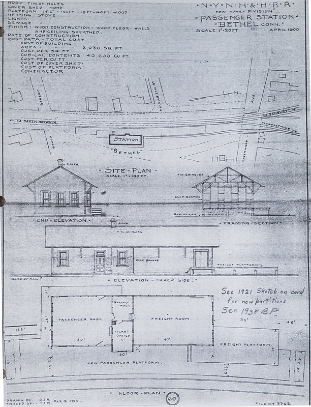
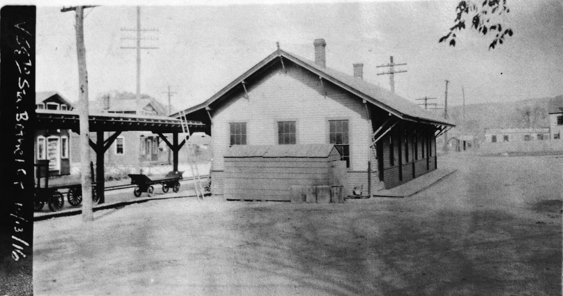
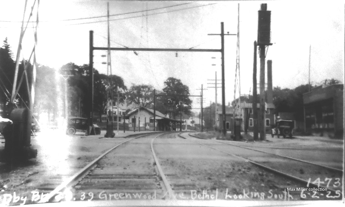
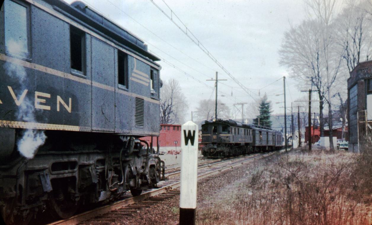
BETHEL2 [NYNH&H, 1899]
The railroad commissioners mention that a new station was built here in 1899. As it was nearing completion, a Danbury News article in May said that "the interior of the new station is fitted up very comfortably. The waiting room is neatly finished off and furnished with all the accommodations necessary. The ticket and telegraph office is in the center of the building, between the freight and passenger departments. Agent McMahon has a cozy little office, and just opposite is a small baggage room, which will be in charge of Baggagemaster Beaupin. The new station, although not a large one, will probably meet all requirements, and is certainly substantially built and nicely arranged." The card at [1] is postmarked 9/14/1908. Note the coach standing at left, the unusual side-mounted double order board in the middle and the freight ramp at right with the little girl standing on it. Likely from the 1910s, the undated real estate card at [3] gives details and dimensions, including the "cubage" of 36,000 cubic feet; the build date is given erroneously as 1897. The ICC val photo at [2] looks northward on 10/13/1916. The southward-looking PUC inspection photo at [4] is dated 6/2/1925. Note the newly installed catenary towers, to be operational within a month. Electrification was discontiued early in 1961. The shot at [5] looks like the 1960s with the NH in block letters and at [6] EP-2s meet at Bethel lower siding just to the south. The architectural sketch at [7] is dated April, 1900, a year later than the 1899 that the newspaper gives for the opening of this station. Wouldn't the plans have to be drawn before the depot was built? Between this and the real estate card at [3] we wonder how reliable the dates on any of these 'official' documents are. Further improvements here were cited in the June, 1909 annual report which puts Bethel in the category of "new passenger stations or increased facilities in progress or to be completed in the coming year." [REFS: NBE/04/28/1899/02; DN/05/24/1899/??; CRC47.1899.30; NHAR38.1909.7; HC/06/13/1925/24; P84,89][rev122417, 051422]
The railroad commissioners mention that a new station was built here in 1899. As it was nearing completion, a Danbury News article in May said that "the interior of the new station is fitted up very comfortably. The waiting room is neatly finished off and furnished with all the accommodations necessary. The ticket and telegraph office is in the center of the building, between the freight and passenger departments. Agent McMahon has a cozy little office, and just opposite is a small baggage room, which will be in charge of Baggagemaster Beaupin. The new station, although not a large one, will probably meet all requirements, and is certainly substantially built and nicely arranged." The card at [1] is postmarked 9/14/1908. Note the coach standing at left, the unusual side-mounted double order board in the middle and the freight ramp at right with the little girl standing on it. Likely from the 1910s, the undated real estate card at [3] gives details and dimensions, including the "cubage" of 36,000 cubic feet; the build date is given erroneously as 1897. The ICC val photo at [2] looks northward on 10/13/1916. The southward-looking PUC inspection photo at [4] is dated 6/2/1925. Note the newly installed catenary towers, to be operational within a month. Electrification was discontiued early in 1961. The shot at [5] looks like the 1960s with the NH in block letters and at [6] EP-2s meet at Bethel lower siding just to the south. The architectural sketch at [7] is dated April, 1900, a year later than the 1899 that the newspaper gives for the opening of this station. Wouldn't the plans have to be drawn before the depot was built? Between this and the real estate card at [3] we wonder how reliable the dates on any of these 'official' documents are. Further improvements here were cited in the June, 1909 annual report which puts Bethel in the category of "new passenger stations or increased facilities in progress or to be completed in the coming year." [REFS: NBE/04/28/1899/02; DN/05/24/1899/??; CRC47.1899.30; NHAR38.1909.7; HC/06/13/1925/24; P84,89][rev122417, 051422]
|

|
|
|
|
|
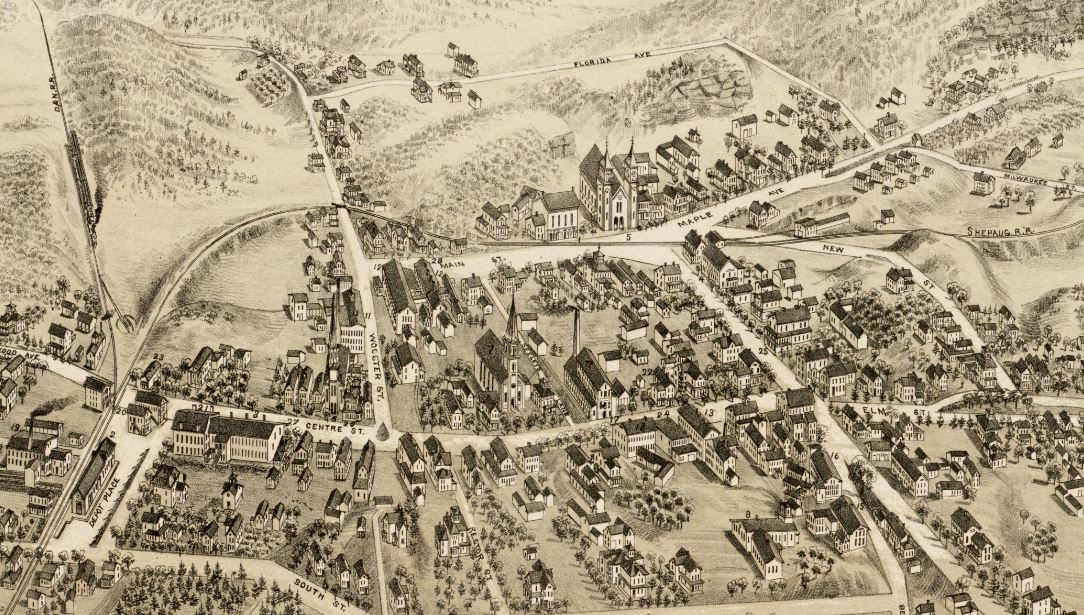
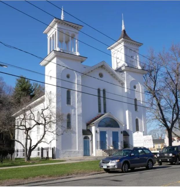
The image at [1] in this lower set shows a broader view from the 1879 O.H. Bailey map. Mr. B., God bless him, accurately tracks the route of the D&N's 1872 Hawleyville Branch. He labels it the Shepaug RR because they operated it. Note the turntable at the junction with the D&N main. This 30-mile short line has an interesting history; it lasted as the NYNH&H's Litchfield Branch until 1948, far longer than any other similar trackage. One newspaper described the Shepaug in 1890 as "... that great sinuous highway over which Litchfield county milk flows to New York at the rate of ten miles an hour..." The HRR leased the D&N in 1886 and for a few short years HRR trains used the cut-off to bypass Danbury and/or access the old NYH&N into the Hat City: see Track 10.5.2ff. In 1891, the NY&NE launched its short-lived "midnight train," the Long Island & Eastern States Express. Trains left Brooklyn NY at 11:00 p.m., took the ferry from Oyster Bay to WILSONS POINT in Norwalk and went on to Boston; you could actually catch a train at Hawleyville at 2:00 a.m. and arrive in Beantown at 7:00 a.m.! This was an impressive amount of activity for a minor branch and in 1890 the HRR/NY&NE alliance gained control of the Shepaug, which had been was reorganized in 1887 as the Shepaug, Litchfield & Northern. The last word is telling; plans were to extend the line north to TORRINGTON or WINSTED and west to New York via RIDGEFIELD. All of this activity was naturally viewed as hostile by the Consolidated. It reacted to this threat as it always did: seize the enemy! And so, in 1892, it leased the HRR and with it the D&N, the NH&D and the SL&N. Form G timetables bear out the transition from NYNH&H management of a still-independent road to full NYNH&H control in 1898 when stockholders approved the transfer. In that year the SL&N debuts as the Litchfield Branch. The First Congregational Church stood as sacred witness to all this history. Bailey gives a pretty accurate portrayal of the stately twin-towered structure at his '5' with the parish house, today housing an art gallery, to its left. The rails are practically on the church steps; imagine going to service and hearing a train whistle literally right out the door! The shot at [2] dates to ca. 1900 and we have put the current corresponding view at [3]. The shot at [4] shows the rails being torn out sometime after the 1911 abandonment, the backdrop again the church. The snippet at [5] is from our Track 11 Google Earth map; it shows the locations of BETHEL1,2,3 and the red arrow points to the church. The handsome structure was built in 1866, a scant few years before the track was laid and it still stands at the 46 Main St. intersection with Maple St. and Chestnut Ave. The stunningly beautiful edifice, seen at [6], is home today to a congregation that eagerly embraces one and all. Click here. [REFS: NBE/09/12/1890/08; WED/12/24/1890/05; BH/05/07/1898/08; C111-112, K60, P76][added 052122]
Wikipedia
BETHEL3 [MN, 1996]
This Metro-North station opened in 1996, at which time BETHEL2, still standing just to the south, was taken out of service. [REFS: R35][rev121816]
This Metro-North station opened in 1996, at which time BETHEL2, still standing just to the south, was taken out of service. [REFS: R35][rev121816]
|
|
|
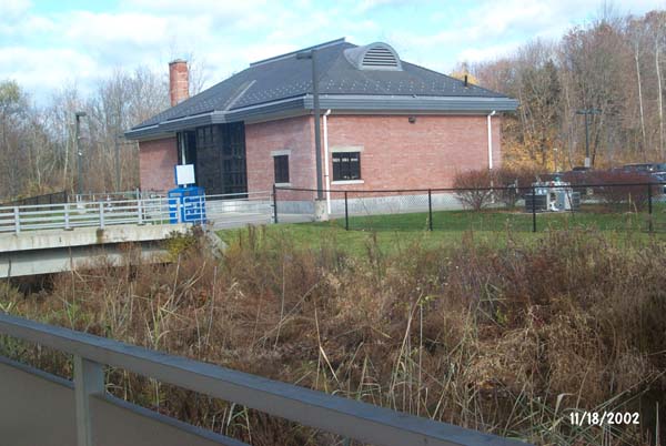
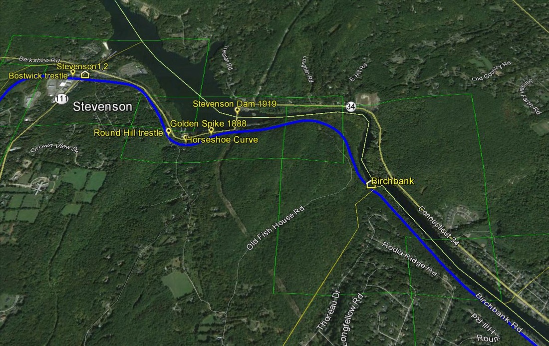
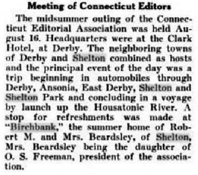
BIRCHBANK [NYNH&H, c1920]
This was an obscure, perhaps seasonal, stop in the town of Shelton that appears on the 6/12/1921 Lines West timetable shown at [1]. Located 2.3 miles south of STEVENSON and 5.1 miles above SHELTON, it has been placed it best we can on the Track 11 Google Earth map snippet at [2]. The station is still listed on the 1/14/24 LWTT but is gone by that of 8/21/1927; passenger service ended on the NH&D Extension in 1925. Interestingly, the stop is found neither on the 1919 ICC station roster or, perhaps more importantly date-wise, on the 4/1/1923 NYNH&H Official List. There have been, however, instances of special stops listed on ETTs, BUCKHOUTS PARK and TORRINGFORD STREET quickly coming to mind, and this one may be well be similar. The oldest reference to a place name here comes in 1919 when publishing-trade periodicals mention that the Connecticut Editorial Association took a boat ride up the Housatonic to "Birchbank," the summer home of Mrs. Robert Beardsley, the daughter of the group's president, O.S. Freeman. Today's Birchbank Rd. ends well short of this point and residents, still revelling in the remoteness of Upper Birchbank, call the area "Wholand." Could the NYNH&H have established a stop for a single cottage, however well-connected the owners might have been? It is a question begging an answer. In the floods of 1955 a switcher and caboose rescued denizens of Birchbank who were trapped by landslides and brought them down to the Shelton passenger station, still standing but closed for nearly thirty years by that time. [REFS: AES/10/17/1955/06][rev012318]
This was an obscure, perhaps seasonal, stop in the town of Shelton that appears on the 6/12/1921 Lines West timetable shown at [1]. Located 2.3 miles south of STEVENSON and 5.1 miles above SHELTON, it has been placed it best we can on the Track 11 Google Earth map snippet at [2]. The station is still listed on the 1/14/24 LWTT but is gone by that of 8/21/1927; passenger service ended on the NH&D Extension in 1925. Interestingly, the stop is found neither on the 1919 ICC station roster or, perhaps more importantly date-wise, on the 4/1/1923 NYNH&H Official List. There have been, however, instances of special stops listed on ETTs, BUCKHOUTS PARK and TORRINGFORD STREET quickly coming to mind, and this one may be well be similar. The oldest reference to a place name here comes in 1919 when publishing-trade periodicals mention that the Connecticut Editorial Association took a boat ride up the Housatonic to "Birchbank," the summer home of Mrs. Robert Beardsley, the daughter of the group's president, O.S. Freeman. Today's Birchbank Rd. ends well short of this point and residents, still revelling in the remoteness of Upper Birchbank, call the area "Wholand." Could the NYNH&H have established a stop for a single cottage, however well-connected the owners might have been? It is a question begging an answer. In the floods of 1955 a switcher and caboose rescued denizens of Birchbank who were trapped by landslides and brought them down to the Shelton passenger station, still standing but closed for nearly thirty years by that time. [REFS: AES/10/17/1955/06][rev012318]
|
|
BIRMINGHAM1 [NH&D, 1872]
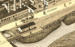
Based on the customary reliability of Mr. Bailey, this sketch of the Birmingham depot in DERBY is probably pretty accurate. Click here for the full 1876 map. This substantial combination station stood west of the track at the northeast corner of Foundry and Second Streets, the latter of which would later become Main St. Rockey says this station opened in March of 1872, but the Journal Courier says it was nearing completion in December of 1871. It was largely paid for and "owned principally" by William E. Downes, who would be on the NH&D board of directors from 1882 to 1889. The depot was "practically ruined" in a serious fire, arson suspected, on June 30, 1879. Lost freight contents included jute, used for manufacturing manila paper, lime belonging to Wilkinson Bros. & Co. of Shelton, and wool for the A.H. & C.B. Alling knitting mill at Birmingham. [REFS: NHJC/12/15/1871/02; NHER/06/30/1879/04; NHDP/07/01/1879/04; NHER/08/01/1879 /04; CRC26.1879.186; R2.377][rev121816]
Based on the customary reliability of Mr. Bailey, this sketch of the Birmingham depot in DERBY is probably pretty accurate. Click here for the full 1876 map. This substantial combination station stood west of the track at the northeast corner of Foundry and Second Streets, the latter of which would later become Main St. Rockey says this station opened in March of 1872, but the Journal Courier says it was nearing completion in December of 1871. It was largely paid for and "owned principally" by William E. Downes, who would be on the NH&D board of directors from 1882 to 1889. The depot was "practically ruined" in a serious fire, arson suspected, on June 30, 1879. Lost freight contents included jute, used for manufacturing manila paper, lime belonging to Wilkinson Bros. & Co. of Shelton, and wool for the A.H. & C.B. Alling knitting mill at Birmingham. [REFS: NHJC/12/15/1871/02; NHER/06/30/1879/04; NHDP/07/01/1879/04; NHER/08/01/1879 /04; CRC26.1879.186; R2.377][rev121816]
Connecticut Historical Society
|
|
|
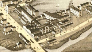
BIRMINGHAM2 [NH&D, 1879]
This station debuted in early August, 1879, just a month after the first one burned. With an 1886 article in the Register referring to "freight rooms" in this depot, the new structure must have initially been a combination station like its predecessor. An actual freight wing was added in 1883 at a cost of $2200, according to a letter on 11/30/1883 to the railroad commissioners from Supt. Quintard. The image at [1] probably is ca. 1900. The shot at [2] is a Lewis H. Benton photo of a photo that he captioned as 'Housatonic R.R. station, Birmingham, 1871-1902' and gave it a #5155 designation in his historical photo series. Our research has shown that he assembled his 4,000+ image collection from 1910 to ca. 1936. The only clue here is that it was taken after 1902; his 1871 build date is incorrect and his HRR attribution has to be taken as current, discounting the NH&D origins. The photo at [3] shows the huge area to the east that was filled in for the double-tracking of the NH&D line that would become the new Naugatuck Division on the west bank of its namesake river. The NYNH&H had gained control of this property in 1892 with its lease of the HRR and all its lessors and changed this station name to DERBY in 1896 to reflect the borough becoming the city of Derby in 1893. The old NRR depot on the east side of the Naugatuck River, DERBY1, was renamed EAST DERBY at that time. See DERBY3 for the new sttion and freight house that would open on this fill in 1903. See Track 4C, MP 4.63.1 for more. [REFS: NHDP/07/01/1879/04; NHER/08/01/1879/04; NHDP/08/08/1879/04(?); BA33.1880.00; NHER/1886/03/06/04; HC/06/26/1896/11][rev121816]
This station debuted in early August, 1879, just a month after the first one burned. With an 1886 article in the Register referring to "freight rooms" in this depot, the new structure must have initially been a combination station like its predecessor. An actual freight wing was added in 1883 at a cost of $2200, according to a letter on 11/30/1883 to the railroad commissioners from Supt. Quintard. The image at [1] probably is ca. 1900. The shot at [2] is a Lewis H. Benton photo of a photo that he captioned as 'Housatonic R.R. station, Birmingham, 1871-1902' and gave it a #5155 designation in his historical photo series. Our research has shown that he assembled his 4,000+ image collection from 1910 to ca. 1936. The only clue here is that it was taken after 1902; his 1871 build date is incorrect and his HRR attribution has to be taken as current, discounting the NH&D origins. The photo at [3] shows the huge area to the east that was filled in for the double-tracking of the NH&D line that would become the new Naugatuck Division on the west bank of its namesake river. The NYNH&H had gained control of this property in 1892 with its lease of the HRR and all its lessors and changed this station name to DERBY in 1896 to reflect the borough becoming the city of Derby in 1893. The old NRR depot on the east side of the Naugatuck River, DERBY1, was renamed EAST DERBY at that time. See DERBY3 for the new sttion and freight house that would open on this fill in 1903. See Track 4C, MP 4.63.1 for more. [REFS: NHDP/07/01/1879/04; NHER/08/01/1879/04; NHDP/08/08/1879/04(?); BA33.1880.00; NHER/1886/03/06/04; HC/06/26/1896/11][rev121816]

BLACK HALL1 [NH&NL, 1852?]
This stop in the town of Old Lyme dates back to the 1852 opening of the NH&NL and a station is noted on the 1854NL map. We have assumed that there was some early structure here but we have no photo as of yet.[rev071315]
This stop in the town of Old Lyme dates back to the 1852 opening of the NH&NL and a station is noted on the 1854NL map. We have assumed that there was some early structure here but we have no photo as of yet.[rev071315]

BLACK HALL2 [NYNH&H, 1883]
Erected in 1883, the railroad commissioners said that a new station was being built in their 1884 report covering the previous calendar year. The double-tracked main line would date this photo to after that project was completed from NEW LONDON to LEETES ISLAND in 1893. We think this photo looks west with the telegraph poles on the south side of the tracks, as seen at LYME2 also. This depot would be replaced in 1907 by a centralized LYME AND BLACK HALL station at Way's crossing that eliminated the two separate predecessors. [REFS: CRC31.1884.20; RRC38.15 (4/16/1906)][rev071715; rrd121816]
Erected in 1883, the railroad commissioners said that a new station was being built in their 1884 report covering the previous calendar year. The double-tracked main line would date this photo to after that project was completed from NEW LONDON to LEETES ISLAND in 1893. We think this photo looks west with the telegraph poles on the south side of the tracks, as seen at LYME2 also. This depot would be replaced in 1907 by a centralized LYME AND BLACK HALL station at Way's crossing that eliminated the two separate predecessors. [REFS: CRC31.1884.20; RRC38.15 (4/16/1906)][rev071715; rrd121816]
BLACK POINT [> CRESCENT BEACH]
BLAKES SUMMIT [> WASHINING]
BLAKES SUMMIT [> WASHINING]
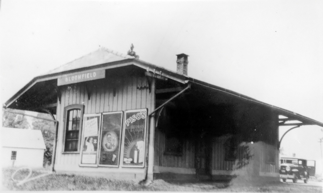
|
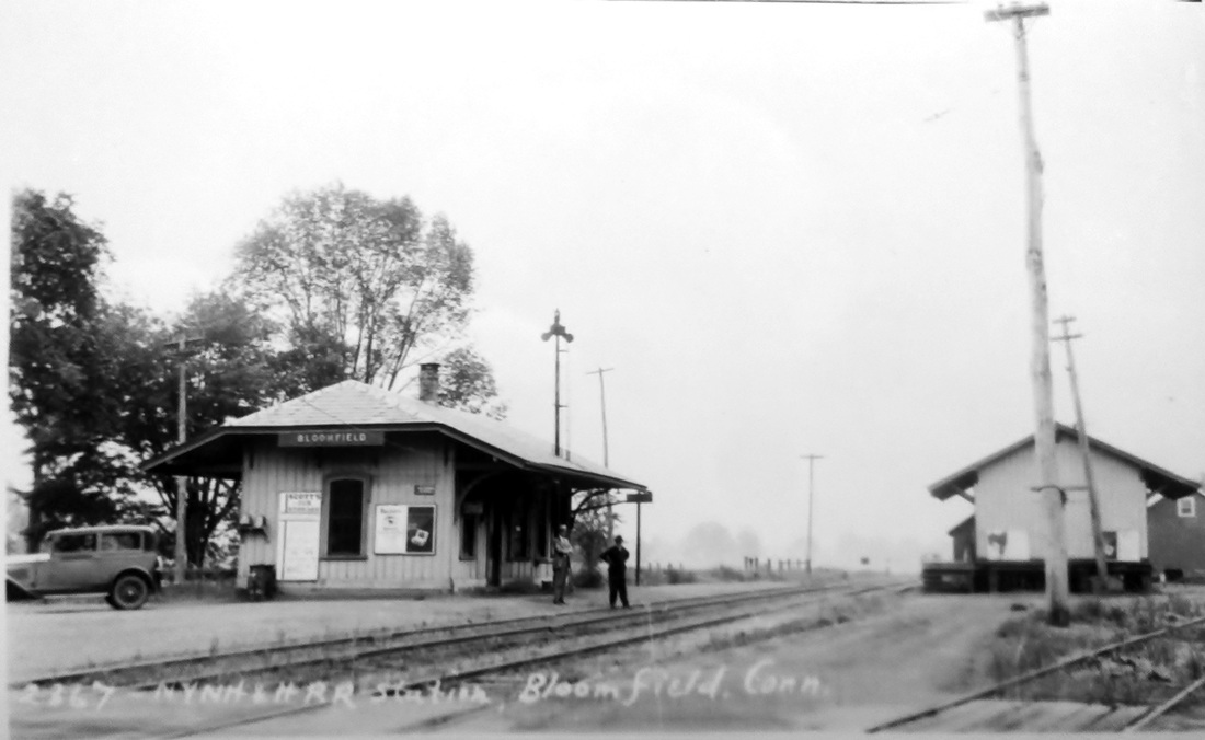
|
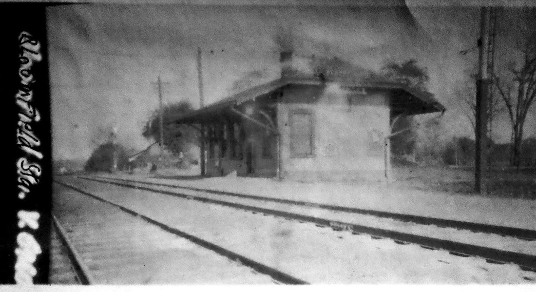
|
BLOOMFIELD [CW, 1872]
This was an original stop on the CW when it opened on 12/21/1871. The foundation was already laid, according to the Courant, but the station was not finished until early 1872, the Winsted Herald saying in February that "the depot structure is ready for the plasterers." The appraisal done for the projected NY&NE lease of the CW said in 1880 that the station condition was good at the time, that it needed about $200 in repairs, and that the overall value was $1500. The building was razed on 5/31/1940, according to the notation on a photo in our collection; the 7/19/1940 SSRR addendum says it was removed on 5/25/1940. [REFS: HDC/12/14/1871/02; WH/02/02/1872/02; D16][rev010518]
This was an original stop on the CW when it opened on 12/21/1871. The foundation was already laid, according to the Courant, but the station was not finished until early 1872, the Winsted Herald saying in February that "the depot structure is ready for the plasterers." The appraisal done for the projected NY&NE lease of the CW said in 1880 that the station condition was good at the time, that it needed about $200 in repairs, and that the overall value was $1500. The building was razed on 5/31/1940, according to the notation on a photo in our collection; the 7/19/1940 SSRR addendum says it was removed on 5/25/1940. [REFS: HDC/12/14/1871/02; WH/02/02/1872/02; D16][rev010518]
|

|
BLUE HILLS [CW, 1871]
This was an obscure stop in HARTFORD two miles north of Union Station, shown by the red arrow on the current day map at [1]. It was not mentioned in the pre-opening list of stations but it was on the opening day list and on the 12/21 timetable at [2] it appears as a flag stop, like HOSKINS and CANTON. The map to the left shows the approximate location. No other historical reference or representation has been found and how long it was used is unknown. [REFS: HDC/12/14/1871/02; HDC/12/21/1871/02][rev121816]
This was an obscure stop in HARTFORD two miles north of Union Station, shown by the red arrow on the current day map at [1]. It was not mentioned in the pre-opening list of stations but it was on the opening day list and on the 12/21 timetable at [2] it appears as a flag stop, like HOSKINS and CANTON. The map to the left shows the approximate location. No other historical reference or representation has been found and how long it was used is unknown. [REFS: HDC/12/14/1871/02; HDC/12/21/1871/02][rev121816]

|
|

|
BOARDMANS BRIDGE [HRR, c1873?]
An important part of the railroad business here at this New Milford stop was milk, as evidenced by the cans seen on the platform in the 1916 val photo at [1]. The HRR was known for bringing the dairy products of Litchfield County down for shipment to New York City and reportedly ran the first scheduled milk train in the country. Its first train carried 1760 quarts on 10/1/1867, the average was 9200 quarts in 1868 and in 1869 it was up to 15,000 quarts. Dairymen meeting at New Milford to form the Housatonic Milk Association in 1873 may have initiated service here. Our 1894 public timetable does not list this station but 1907, 1909, 1911 and 1923 public timetables do have it, mostly as a flag stop for one or two daily and even some Sunday trains. This station stood in the northwestern quadrant of the grade crossing. The 9/25/1924 PUC photo at [2] looks west. The BOARDMANS BRIDGE location is shown on the 1893 map at [3] and the present day map at [4]. [REFS: SR/01/17/1870/08/; HDC/02/17/ 1873/04; D63] [rev112713, 121816]
An important part of the railroad business here at this New Milford stop was milk, as evidenced by the cans seen on the platform in the 1916 val photo at [1]. The HRR was known for bringing the dairy products of Litchfield County down for shipment to New York City and reportedly ran the first scheduled milk train in the country. Its first train carried 1760 quarts on 10/1/1867, the average was 9200 quarts in 1868 and in 1869 it was up to 15,000 quarts. Dairymen meeting at New Milford to form the Housatonic Milk Association in 1873 may have initiated service here. Our 1894 public timetable does not list this station but 1907, 1909, 1911 and 1923 public timetables do have it, mostly as a flag stop for one or two daily and even some Sunday trains. This station stood in the northwestern quadrant of the grade crossing. The 9/25/1924 PUC photo at [2] looks west. The BOARDMANS BRIDGE location is shown on the 1893 map at [3] and the present day map at [4]. [REFS: SR/01/17/1870/08/; HDC/02/17/ 1873/04; D63] [rev112713, 121816]
BOLLES GROVE [> THAMES GROVE]
|
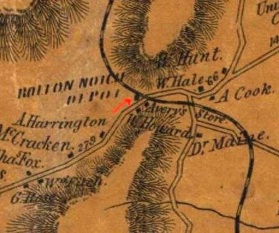
|
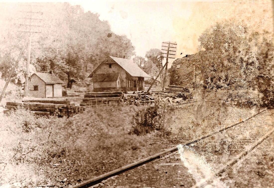
|
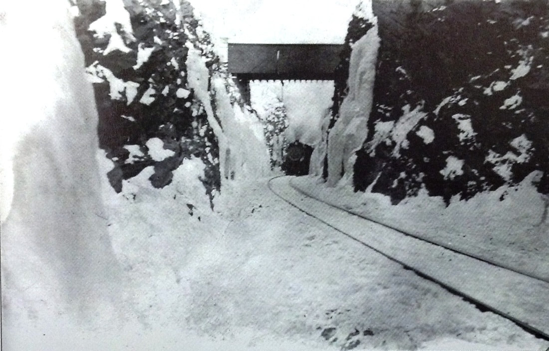
BOLTON1 [HP&F, 1849]
The town of this name in Tolland County is renowned for The Notch, the rift in the mountain which the railroad deepened, work beginning in 1847 and took more than a year to complete. A correspondent for the Newark Daily News came all the way up from New Jersey to ride the new road and heralded the commencement of regular operation which he says was on 11/26/1849. He goes on to say that "... At 'The Notch' it is cut through the solid rock for more than a mile, and to the depth of 45 to 60 feet. On each side of 'The Notch' the road is dug out of the sides of almost perpendicular mountain ledges.... The road is one of the curiosities of the age. It shows us what enterprise can do in overcoming stubborn difficulties." High praise indeed, and S.L.T, as he signed his report, encourages others to ride and see this impressive achievement. This is not the first nor the last time that the railroad would open up and even create magnificent vistas in this state and across the nation. The undated image at [1] is a northeasterly view of the station. The 1857TC map at [2] shows the location of the depot and a grade crossing which was the only way over the tracks until The Notch was bridged. More on that in the next entry. Note the simple but ornamental bracket work up in the station's eave and the triangular support for what must have been the order board. The image at [3] is a rare view of the yard area south of the depot, where the depot first stood between tracks. The NY&NE later created a lake here as a tourist attraction and ice was also cut from the pond during the winters. The railroad otherwise served the slate and flagstone quarries that mined the rock deposits east of the station, reportedly as far back as the early 1800s. The undated photo at [4] shows a westbound train heading through The Notch and under the ca. 1849 wooden bridge over the chasm. The railroad commissioners reported that BOLTON1 burned and was replaced by a new structure in 1902. The fire on 5/23/1902 and was thought to have been caused by sparks from the Boston Flyer, which passed the station around 5:22 in the afternoon. Station agent Alsever and others were unable to save the building, which also housed the Bolton Notch post office, but did rescue the mail and the rest of the station's contents. A passenger coach and freight car were being used and expected to serve until the new depot could be built. [REFS: CRC50.1902.21; HC/12/14/1849/02; HC/02/27/1886/02; NYT/08/08/1887/03; HC/10/19/1893/08: ice house burns; HC/05/24/1902/15][rev041516, rev110421][currently under revision]
The town of this name in Tolland County is renowned for The Notch, the rift in the mountain which the railroad deepened, work beginning in 1847 and took more than a year to complete. A correspondent for the Newark Daily News came all the way up from New Jersey to ride the new road and heralded the commencement of regular operation which he says was on 11/26/1849. He goes on to say that "... At 'The Notch' it is cut through the solid rock for more than a mile, and to the depth of 45 to 60 feet. On each side of 'The Notch' the road is dug out of the sides of almost perpendicular mountain ledges.... The road is one of the curiosities of the age. It shows us what enterprise can do in overcoming stubborn difficulties." High praise indeed, and S.L.T, as he signed his report, encourages others to ride and see this impressive achievement. This is not the first nor the last time that the railroad would open up and even create magnificent vistas in this state and across the nation. The undated image at [1] is a northeasterly view of the station. The 1857TC map at [2] shows the location of the depot and a grade crossing which was the only way over the tracks until The Notch was bridged. More on that in the next entry. Note the simple but ornamental bracket work up in the station's eave and the triangular support for what must have been the order board. The image at [3] is a rare view of the yard area south of the depot, where the depot first stood between tracks. The NY&NE later created a lake here as a tourist attraction and ice was also cut from the pond during the winters. The railroad otherwise served the slate and flagstone quarries that mined the rock deposits east of the station, reportedly as far back as the early 1800s. The undated photo at [4] shows a westbound train heading through The Notch and under the ca. 1849 wooden bridge over the chasm. The railroad commissioners reported that BOLTON1 burned and was replaced by a new structure in 1902. The fire on 5/23/1902 and was thought to have been caused by sparks from the Boston Flyer, which passed the station around 5:22 in the afternoon. Station agent Alsever and others were unable to save the building, which also housed the Bolton Notch post office, but did rescue the mail and the rest of the station's contents. A passenger coach and freight car were being used and expected to serve until the new depot could be built. [REFS: CRC50.1902.21; HC/12/14/1849/02; HC/02/27/1886/02; NYT/08/08/1887/03; HC/10/19/1893/08: ice house burns; HC/05/24/1902/15][rev041516, rev110421][currently under revision]

|
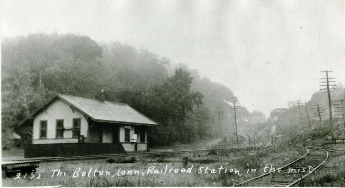
|
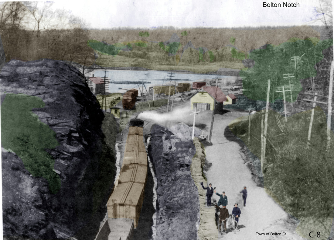
|
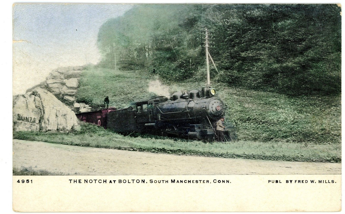
|
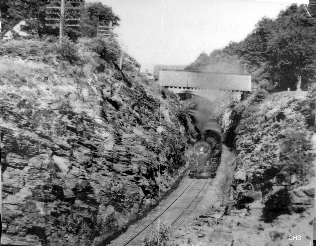
|

C.A. Brown Collection
|
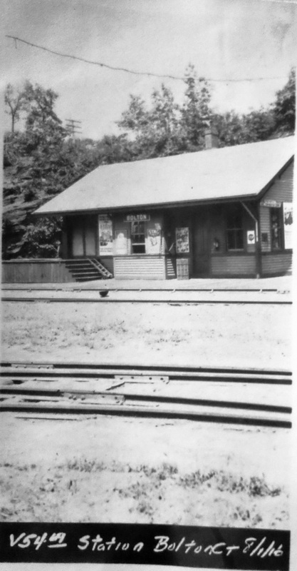 Al Lawrence Collection
BOLTON2 [NYNH&H, 1902]
The old station burned, as noted above, and was replaced by this one. The architectural plan at [7] has a date of June, 1902 so the railroad wasted no time in preparing a replacement that likely opened later in 1902. The photo at [1] is dated 3/29/1904 and the top captioning, however authoritative, says that this was a standard passenger station, so the plan was likely in the railroad files already and that added to the speed of the replacement. See PINE ORCHARD3 for its similar style. The caption also refers to an outhouse on the left which we do not see in this northwestward facing photo. The image at [2] is Lewis H. Benton no. 2155 taken in 1928, likely June "in the mist." This depot had a peculiar distinction later in 1902 when it became the western end of a telephone line that was strung along the tracks. The 12-subscriber Bolton & Coventry Telephone Association contracted with the Southern New England Telephone Co. to give long-distance connections. The Courant article says that the cost to the association for rental space in the depot was six cents per year! Though through-Boston passenger service on this line lasted until the 1955 floods and trains were stopping here until 1928, New England Transportation Co. motor coaches had taken over by 1930 and all service at this location was gone by 1947. The BOLTON2 station was reportedly removed on 4/15/1939, date we cannot verify at this time. The old bridge, only partially covered later in life was replaced in 1955 with a cloverleaf highway crossing and a tunnel for the railroad line. [REFS: CRC50.1902.21; HC/12/15/1902/09; HC/10/08/1910/15: wreck on 10/07; HC/05/15/1952/23A; HC/01/21/1955/8A; 1923, 1937, 1947TTs; K84][rev041516, 110821]
The old station burned, as noted above, and was replaced by this one. The architectural plan at [7] has a date of June, 1902 so the railroad wasted no time in preparing a replacement that likely opened later in 1902. The photo at [1] is dated 3/29/1904 and the top captioning, however authoritative, says that this was a standard passenger station, so the plan was likely in the railroad files already and that added to the speed of the replacement. See PINE ORCHARD3 for its similar style. The caption also refers to an outhouse on the left which we do not see in this northwestward facing photo. The image at [2] is Lewis H. Benton no. 2155 taken in 1928, likely June "in the mist." This depot had a peculiar distinction later in 1902 when it became the western end of a telephone line that was strung along the tracks. The 12-subscriber Bolton & Coventry Telephone Association contracted with the Southern New England Telephone Co. to give long-distance connections. The Courant article says that the cost to the association for rental space in the depot was six cents per year! Though through-Boston passenger service on this line lasted until the 1955 floods and trains were stopping here until 1928, New England Transportation Co. motor coaches had taken over by 1930 and all service at this location was gone by 1947. The BOLTON2 station was reportedly removed on 4/15/1939, date we cannot verify at this time. The old bridge, only partially covered later in life was replaced in 1955 with a cloverleaf highway crossing and a tunnel for the railroad line. [REFS: CRC50.1902.21; HC/12/15/1902/09; HC/10/08/1910/15: wreck on 10/07; HC/05/15/1952/23A; HC/01/21/1955/8A; 1923, 1937, 1947TTs; K84][rev041516, 110821]
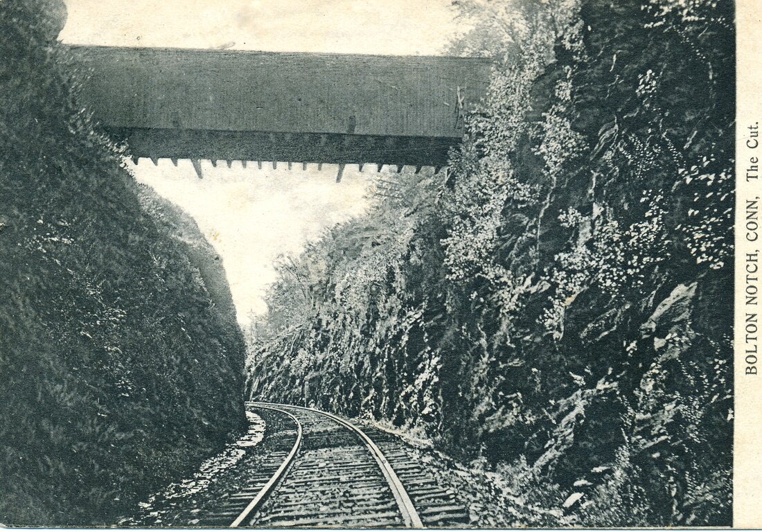
Ed Ozog Collection
|
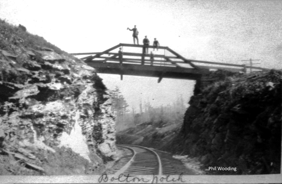
McCoid/Wooding Collection
|
TylerCityStation Collection
|
 McCoid/Wooding Collection
To paraphrase a recent literary title, we have jocularly named this little paragraph The Bridges of Bolton, Connecticut! We think there were four total, including the 1955 tunnel in use today on the rail trail. Unfortunately we find a fair amount of confusion on the subject. We see at [1] what is reportedly the first bridge built in 1849 when the HP&F opened, though there is some assertion that this bridge was not built until the Civil War. One source calls this structure a pony-truss bridge. That type, as best we can determine, is one that has no cross bracing at the top. This one had a roof but possibly no further bracing since the covering had mostly blown off. The wind through the narrow rift can be quite ferocious and has lent itself to a number of stories of ghostly voices as well! A 1952 article alerted readers to the imminent demise of the now partially covered struture due to upcoming highway construction, saying that "... The bridge, erected in 1849, has long since lost its roof but the sideboards, extending some 10 feet up in the air, still remain." The undated photo at [2] shows a bona-fide pony truss; this probably coexisted with the first one, a short distance away perhaps at the site of the concrete bridge, seen at [3] that was built in 1918. We are not certain of the fate of that one in the 1955 reconfiguration of this busy junction of U.S. 6 and 44 which saw the building of the railroad tunnel seen at [4]. Likley it was demolished. The highway was further improved when I-84 was opened to this point, becoming I-384. This evolution is presented tentatively at his time and is subject to further clarification. Comments are welcome! [REFS: HC/05/15/1952/23A; HC/09/10/1971/50C; HC/12/11/1984/B2][currently under revision]
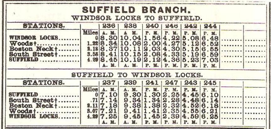
|
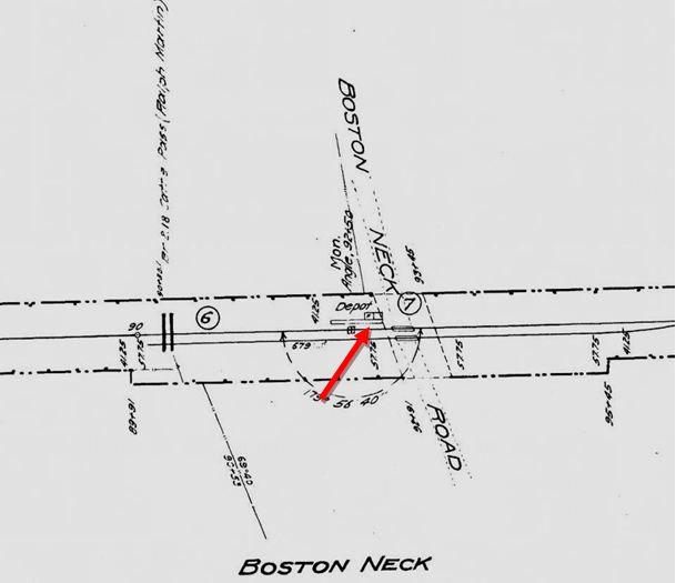
|
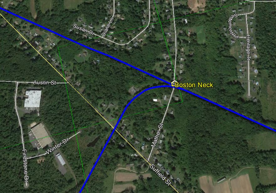
|
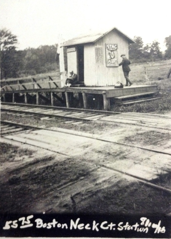 National Archives
BOSTON NECK [WL&S, 1870]
The small structure in SUFFIELD seen in the 8/10/1916 val photo at [4] stood in the southwest quadrant of the crossing at Mather St., then apparently a part of Boston Neck Rd. The 7/15/1894rev timetable at [1] shows this flag stop, as well as WOODS and SOUTH STREET, on the branch that terminated in at SUFFIELD. According to an article in the Springfield Republican all were original stations at the time of the 12/12/1870 opening of the Windsor Locks and Suffield RR. In spite of that early inauguration date, no stations on this 4.5-mile line are shown on the RRM maps, perhaps for reasons of space, and this is the only one that begins to appear on the RAM maps in 1904. The BOSTON NECK location is shown on the val map at [2]. We do not know whether there was a depot earlier than the one shown at [4] but the newspaper says clearly that there were structures here and at WOODS when one at SOUTH STREET was built in 1890. Though chartered as the WL&S, the line was constructed by the H&NH, with an eye on continuing to Westfield, Mass. for a direct western connection with the Boston & Albany RR without going to Springfield. Those plans never came to fruition. Passenger trains ceased on 1/23/1926 but freight service, especially needed at one time by area tobacco growers, continued into Conrail. Up for abandonment by Connecticut Southern in 2012 and challenged by the town, track is thought to still be in the ground today. The Bradley Airport switch is located here as well, as seen on the snippet from our GE map at [3]; that fact may well play into only partial abandonment of this line from BOSTON NECK to SUFFIELD. [REFS: HDC/12/12/1870/02; SR/12/12/1870/08; CR/12/17/1870/04; HWT/01/23/1890/03; HC/05/27/1911/14; 1907, 1911, 1923TTs; SR/01/17/1926 /02; K75][rev111914, 121816]
The small structure in SUFFIELD seen in the 8/10/1916 val photo at [4] stood in the southwest quadrant of the crossing at Mather St., then apparently a part of Boston Neck Rd. The 7/15/1894rev timetable at [1] shows this flag stop, as well as WOODS and SOUTH STREET, on the branch that terminated in at SUFFIELD. According to an article in the Springfield Republican all were original stations at the time of the 12/12/1870 opening of the Windsor Locks and Suffield RR. In spite of that early inauguration date, no stations on this 4.5-mile line are shown on the RRM maps, perhaps for reasons of space, and this is the only one that begins to appear on the RAM maps in 1904. The BOSTON NECK location is shown on the val map at [2]. We do not know whether there was a depot earlier than the one shown at [4] but the newspaper says clearly that there were structures here and at WOODS when one at SOUTH STREET was built in 1890. Though chartered as the WL&S, the line was constructed by the H&NH, with an eye on continuing to Westfield, Mass. for a direct western connection with the Boston & Albany RR without going to Springfield. Those plans never came to fruition. Passenger trains ceased on 1/23/1926 but freight service, especially needed at one time by area tobacco growers, continued into Conrail. Up for abandonment by Connecticut Southern in 2012 and challenged by the town, track is thought to still be in the ground today. The Bradley Airport switch is located here as well, as seen on the snippet from our GE map at [3]; that fact may well play into only partial abandonment of this line from BOSTON NECK to SUFFIELD. [REFS: HDC/12/12/1870/02; SR/12/12/1870/08; CR/12/17/1870/04; HWT/01/23/1890/03; HC/05/27/1911/14; 1907, 1911, 1923TTs; SR/01/17/1926 /02; K75][rev111914, 121816]
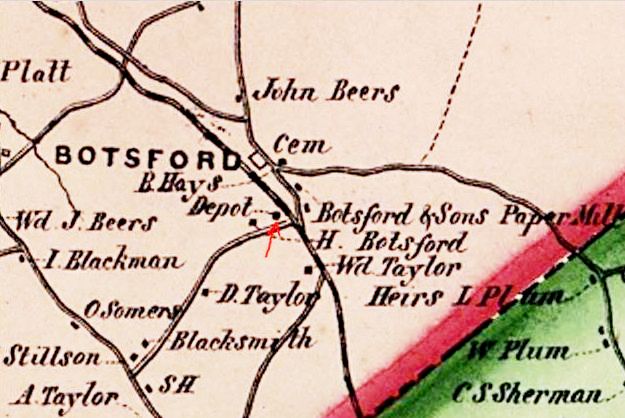
BOTSFORD1 [HRR, 1840]
The location of this NEWTOWN station, as seen on the 1856FC map, was diagonally across what is now Botsford Hill Rd. from where the next depot would stand. Receipts dated 9/30/1887 and 8/3/1889 in the foldered R&LHS material at the Baker Library indicate that the HRR was paying $5 per month to A.B. Blakeman to rent "passenger accommodations... at Botsford Station." We have no photo yet of the rented structure or any predecessor that served as a depot here in Botsford from 1840 until BOTSFORD2 was built. [REFS: B898][rev080515, rrd121816]
The location of this NEWTOWN station, as seen on the 1856FC map, was diagonally across what is now Botsford Hill Rd. from where the next depot would stand. Receipts dated 9/30/1887 and 8/3/1889 in the foldered R&LHS material at the Baker Library indicate that the HRR was paying $5 per month to A.B. Blakeman to rent "passenger accommodations... at Botsford Station." We have no photo yet of the rented structure or any predecessor that served as a depot here in Botsford from 1840 until BOTSFORD2 was built. [REFS: B898][rev080515, rrd121816]
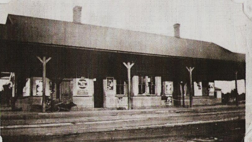
Archives & Special Collections, UConn
|
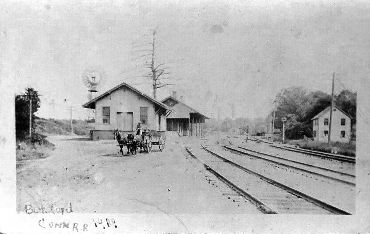
|
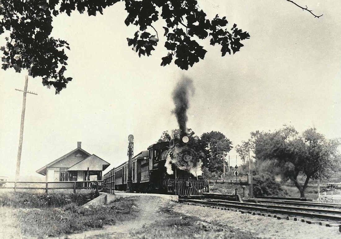
Edward J. Ozog Collection
|

BOTSFORD2 [NYNH&H, 1894]
This station was designed with plans dated October, 1893 and it opened in February of the next year. It replaced an earlier "dilapidated structure," as reported by the Newtown Bee, which said that the new depot was 24x65 feet in size and was painted olive with dark trim. This station is seen, possibly in the 1890s, at [1]. At [2], it is behind the freight depot in a view that precedes the grade crossing elimination and double-tracking of 1910. The date on the photo is 1909. The shot at [3] shows the arrangement after the project was completed with the overpass for today's Botsford Hill Rd. ahead of the train and the concrete abutments looking like they are pretty new. The photo at [4] was taken after a redesign that gave the station a saltbox-like appearance, different enough to make us wonder if it was not a whole new structure. But, at Kevin Daly's suggested closer look, the window and door locations on the front are the same and the exterior molding and wainscoting remain the same. What the railroad did was to shear off the covershed and face the forward edge of the roof with angled boards, giving the structure a much taller profile. The freight station no longer appears in all the photos we have seen after the changes and it is likely that all business was handled in this building after it was remodeled. A 3/23/1962 CT buildings inventory said that the former station, water tank and pump house, delivery track and a parcel of land had been sold but one half of the station building was on railroad land for which the new owner was paying $25 per year for rent. BOTSFORD2 was reportedly used until just after WWII and razed in the 1980s. [REFS: CRC41.1893.21; CRC42.1894.20; NBE/02/23/1894/01][rev010518]
This station was designed with plans dated October, 1893 and it opened in February of the next year. It replaced an earlier "dilapidated structure," as reported by the Newtown Bee, which said that the new depot was 24x65 feet in size and was painted olive with dark trim. This station is seen, possibly in the 1890s, at [1]. At [2], it is behind the freight depot in a view that precedes the grade crossing elimination and double-tracking of 1910. The date on the photo is 1909. The shot at [3] shows the arrangement after the project was completed with the overpass for today's Botsford Hill Rd. ahead of the train and the concrete abutments looking like they are pretty new. The photo at [4] was taken after a redesign that gave the station a saltbox-like appearance, different enough to make us wonder if it was not a whole new structure. But, at Kevin Daly's suggested closer look, the window and door locations on the front are the same and the exterior molding and wainscoting remain the same. What the railroad did was to shear off the covershed and face the forward edge of the roof with angled boards, giving the structure a much taller profile. The freight station no longer appears in all the photos we have seen after the changes and it is likely that all business was handled in this building after it was remodeled. A 3/23/1962 CT buildings inventory said that the former station, water tank and pump house, delivery track and a parcel of land had been sold but one half of the station building was on railroad land for which the new owner was paying $25 per year for rent. BOTSFORD2 was reportedly used until just after WWII and razed in the 1980s. [REFS: CRC41.1893.21; CRC42.1894.20; NBE/02/23/1894/01][rev010518]