Track 12: CT Passenger Stations, HE-K
See TCS Home Page links for notes, abbreviations, and sources.
Use Track 11 map link to locate stations, rail and trolley lines, and POIs.
Use Track 11 map link to locate stations, rail and trolley lines, and POIs.
HEBRON [> TURNERVILLE]

|

Dave Peters Collection
|
|
HIGGANUM [CV, 1871]
There were decorations on this new depot in the town of HADDAM on the CV's opening day in 1871. According to Max Miller, this station caught fire and was razed around 1966. [REFS: HDC/08/25/1871/ 02]
There were decorations on this new depot in the town of HADDAM on the CV's opening day in 1871. According to Max Miller, this station caught fire and was razed around 1966. [REFS: HDC/08/25/1871/ 02]
Max Miller Collection
|

Max Miller Collection
|
Phil Wooding Collection
|
|
|
|
HIGHLAND [M&C, 1885]
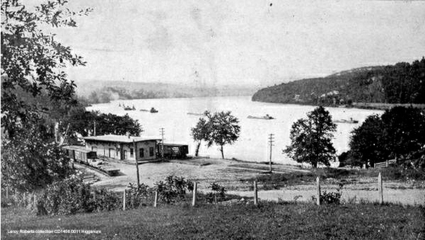
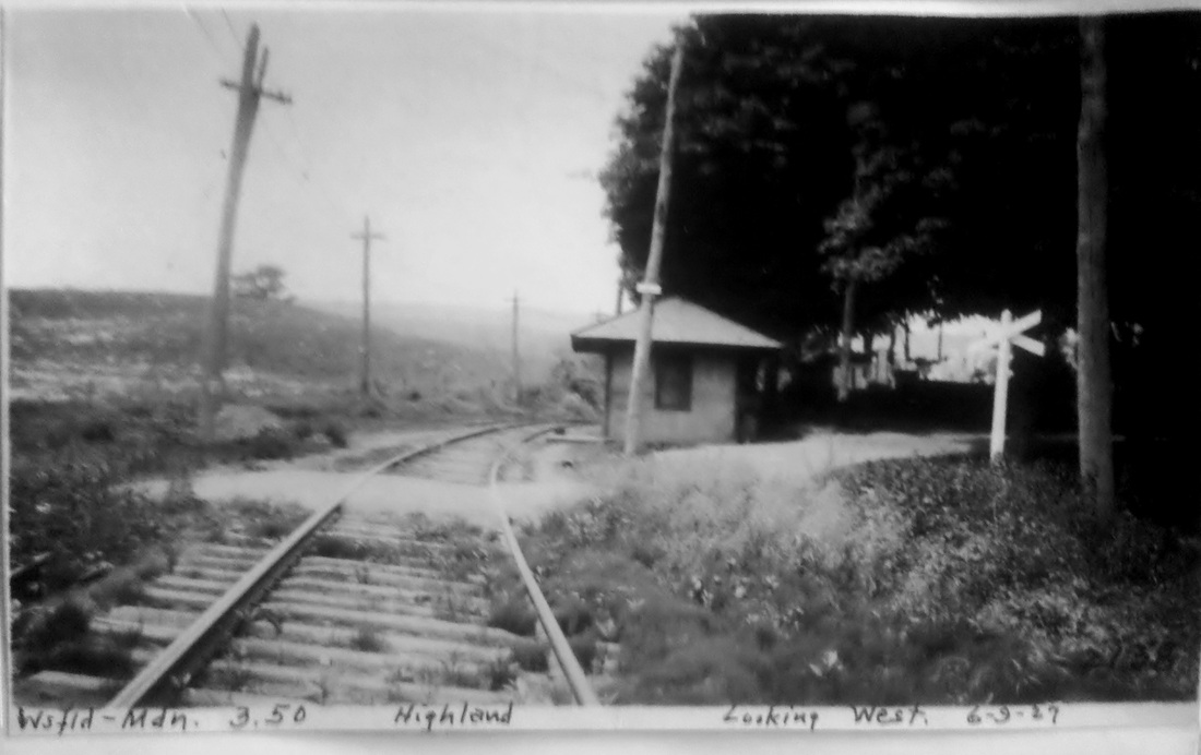
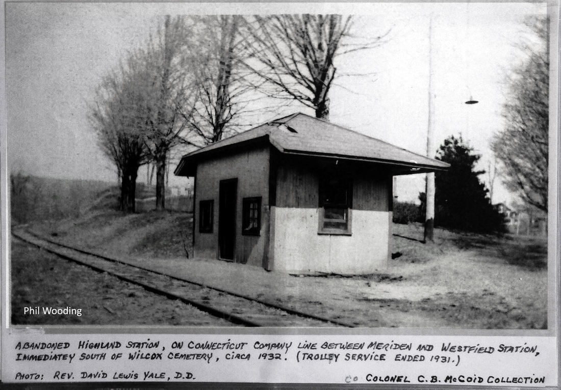
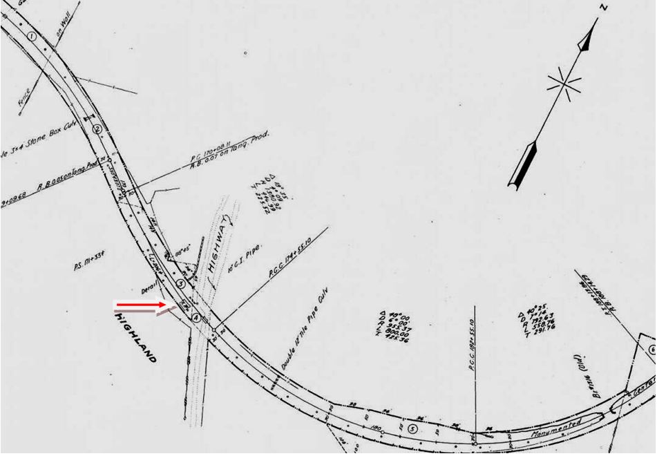
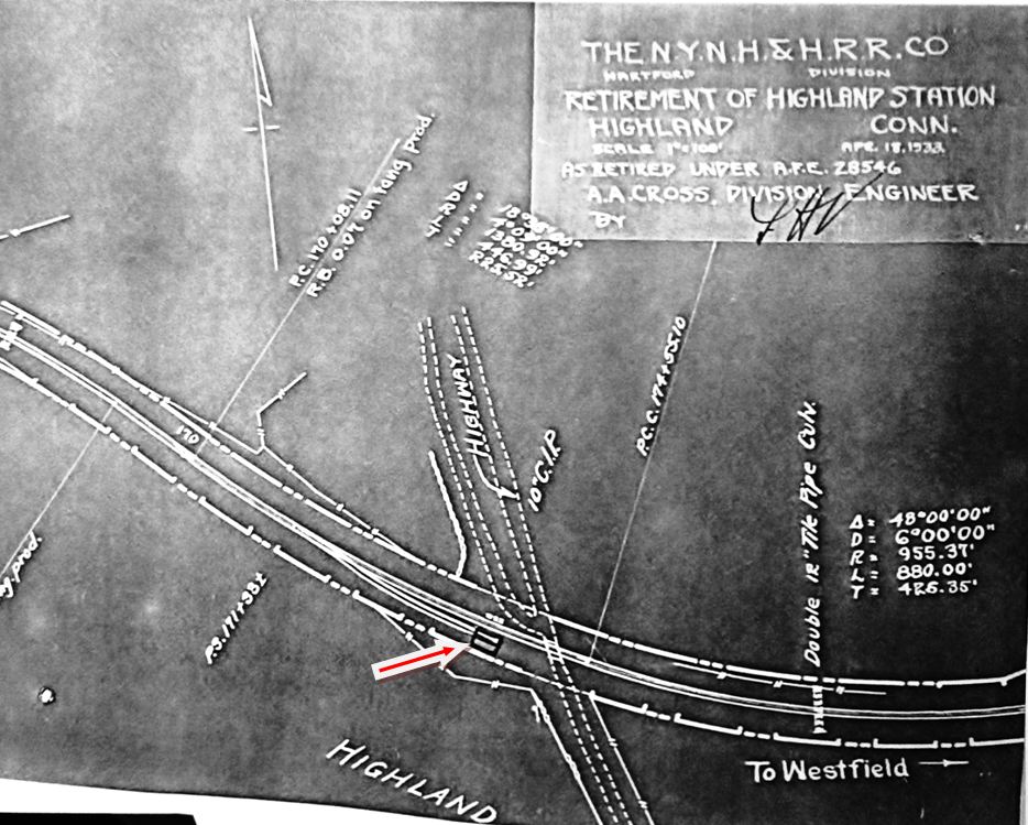
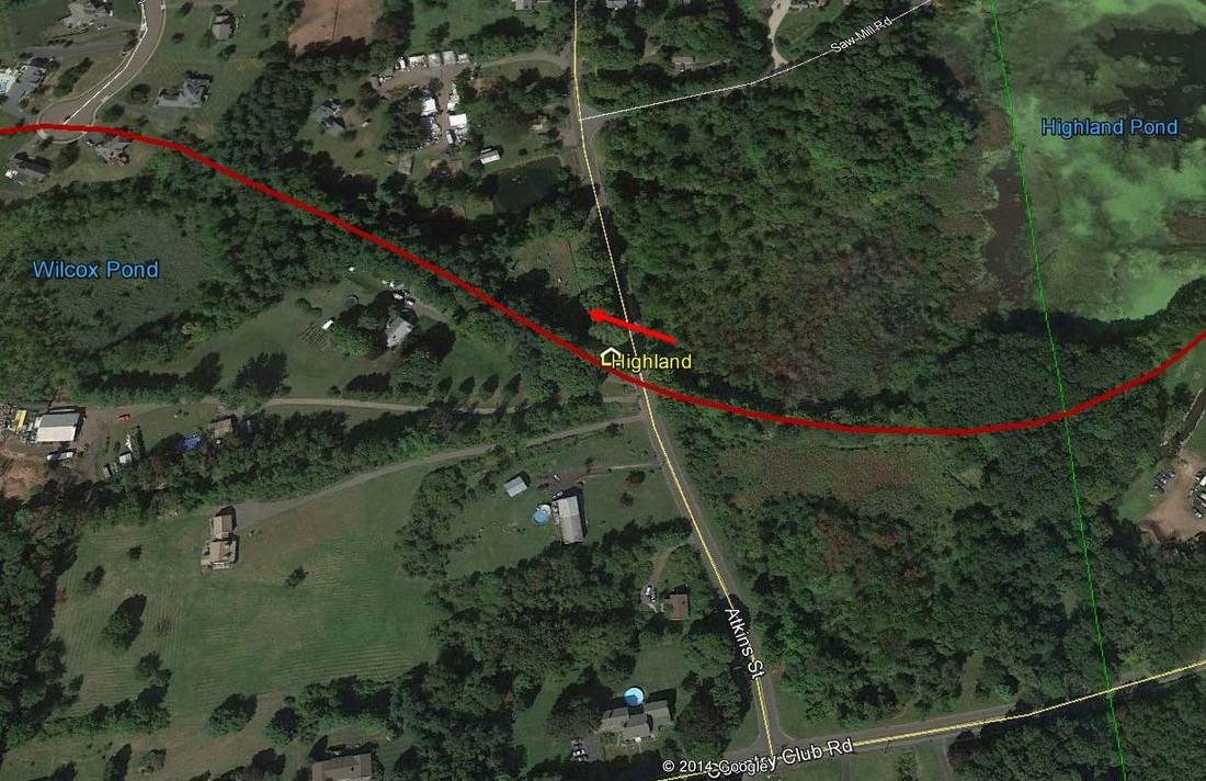
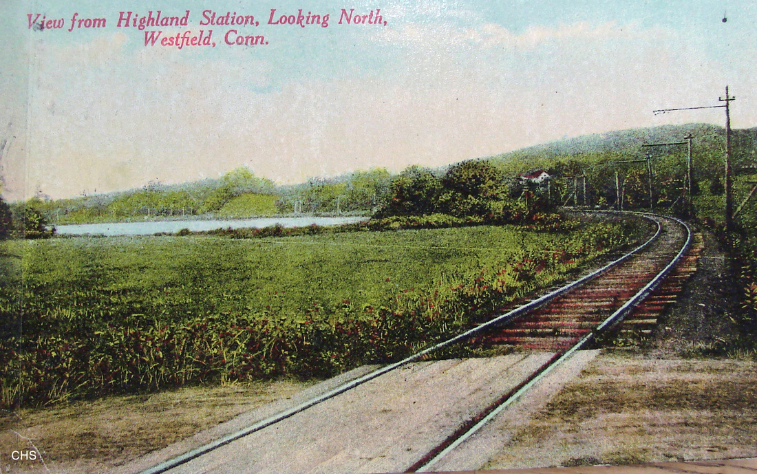
This stop was in the northwestern part of Middletown. Trolleys replaced steam service from MERIDEN to MIDDLETOWN on 7/8/1907 and, according to Snow, the interurbans were kept on the run as far as WESTFIELD until 1932. According to a July, 1931 article entitled "Westfield Would Keep Meriden Trolley Line," vigorous opposition was voiced by residents who would no longer have direct access to the Silver City if passenger service ended on the MW&CR line. EAST MERIDEN, BULLUS, SMITHS and HIGHLAND station riders were also affected and complained that the new highway, today's Rte. 66, through the southern part of Middletown would do them little good. The PUC shots at [1] and [2] are dated 6/9/1927. In the ca. 1932 shot at [3], the pole in front of the depot is gone and the structure has lost its trackside overhang. The photo was once in the collection of Col. C.B. McCoid, an inveterate rail photographer and historian from the Middletown area. This view is probably after the 4/18/1932 station abandonment date shown on the map at [5]. The section of the line from York Hill Quarry to Westfield was not abandoned until 1938. All three upper images show the structure in the northwest quadrant of the Atkins Rd. grade crossing, in front of Wilcox Cemetery, which happens to be the final resting place of railroad promoter and president George Wilcox. Challenging that location are the 1915 val map [4] and the abandonment map [5], on which our red arrows point to the station at the end of a short siding in the southwest quadrant of the crossing. Until we sort out this contradiction, our Track 11 GE map snippet [6] has the station icon matching the photos, with the red arrow pointing to gravestones in the cemetery that sits behind the site. The postcard at [7] looks east toward the lake with the depot out of sight to the right. [REFS: HC/07/07/1905/05; HC/12/28/1906/13; HC/07/08/1907/16; HC/03/16/1927/11; HC/09/17/1927/02; HC/06/25/1931/02; HC/07/17/1931/06; S27][rev070315, 102820]
This stop was in the northwestern part of Middletown. Trolleys replaced steam service from MERIDEN to MIDDLETOWN on 7/8/1907 and, according to Snow, the interurbans were kept on the run as far as WESTFIELD until 1932. According to a July, 1931 article entitled "Westfield Would Keep Meriden Trolley Line," vigorous opposition was voiced by residents who would no longer have direct access to the Silver City if passenger service ended on the MW&CR line. EAST MERIDEN, BULLUS, SMITHS and HIGHLAND station riders were also affected and complained that the new highway, today's Rte. 66, through the southern part of Middletown would do them little good. The PUC shots at [1] and [2] are dated 6/9/1927. In the ca. 1932 shot at [3], the pole in front of the depot is gone and the structure has lost its trackside overhang. The photo was once in the collection of Col. C.B. McCoid, an inveterate rail photographer and historian from the Middletown area. This view is probably after the 4/18/1932 station abandonment date shown on the map at [5]. The section of the line from York Hill Quarry to Westfield was not abandoned until 1938. All three upper images show the structure in the northwest quadrant of the Atkins Rd. grade crossing, in front of Wilcox Cemetery, which happens to be the final resting place of railroad promoter and president George Wilcox. Challenging that location are the 1915 val map [4] and the abandonment map [5], on which our red arrows point to the station at the end of a short siding in the southwest quadrant of the crossing. Until we sort out this contradiction, our Track 11 GE map snippet [6] has the station icon matching the photos, with the red arrow pointing to gravestones in the cemetery that sits behind the site. The postcard at [7] looks east toward the lake with the depot out of sight to the right. [REFS: HC/07/07/1905/05; HC/12/28/1906/13; HC/07/08/1907/16; HC/03/16/1927/11; HC/09/17/1927/02; HC/06/25/1931/02; HC/07/17/1931/06; S27][rev070315, 102820]
|

|
Whittemore Library
|
Mattatuck Museum
|
|
|
 Conn. Historical Soc.
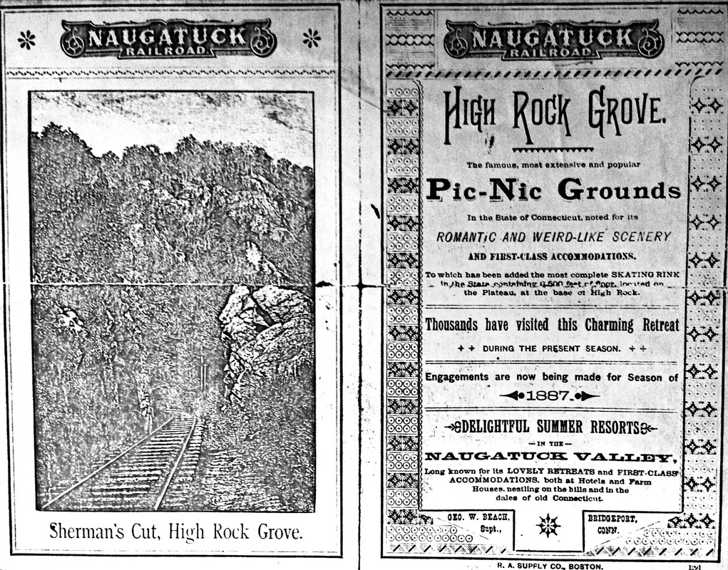
HIGH ROCK GROVE [NRR, 1876]
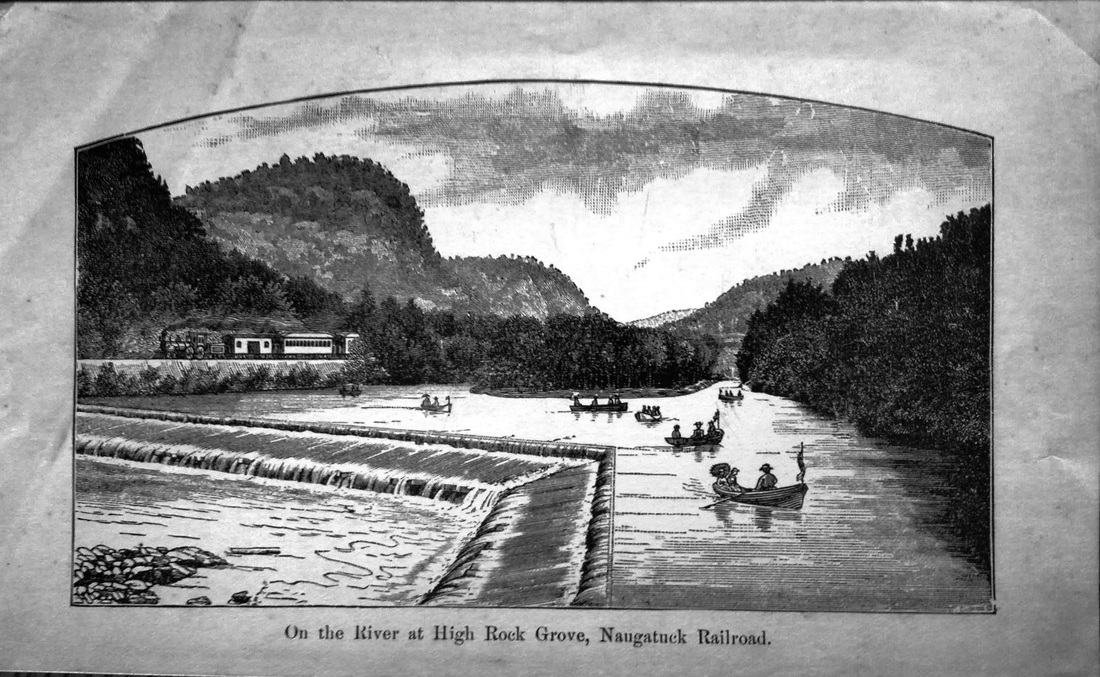
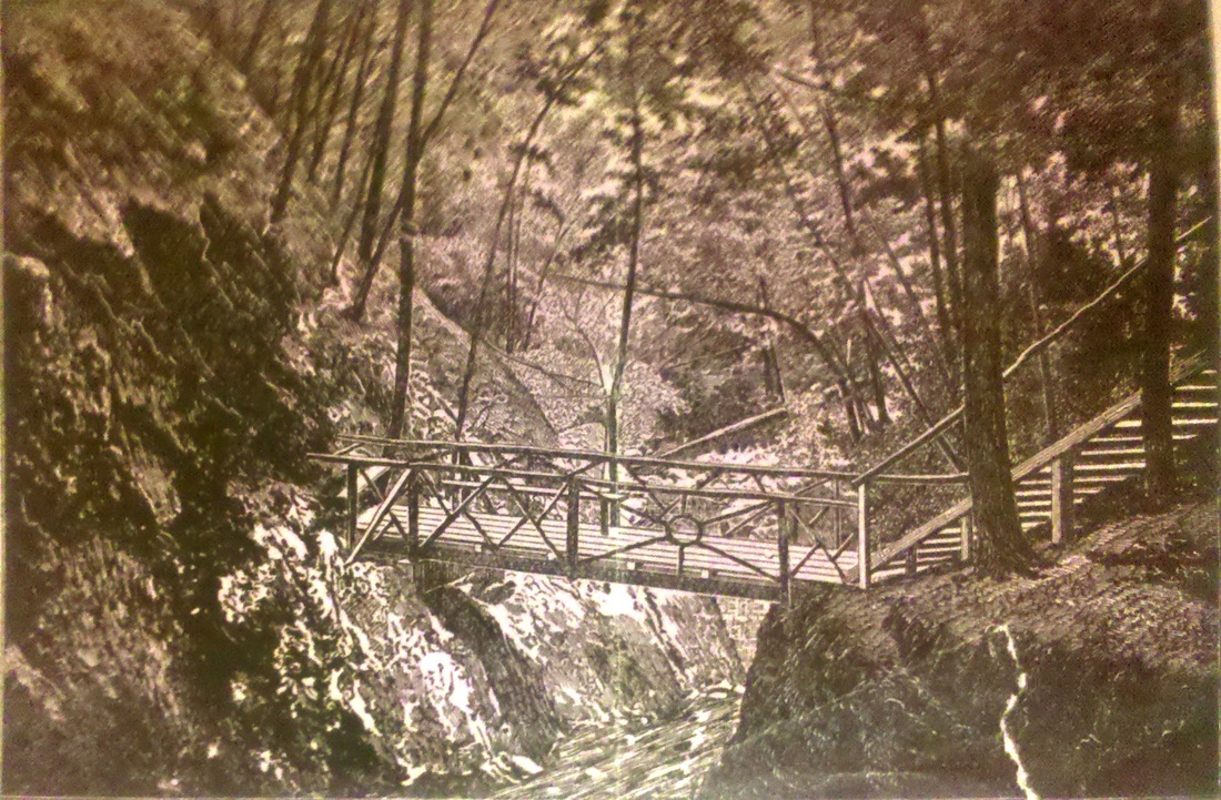
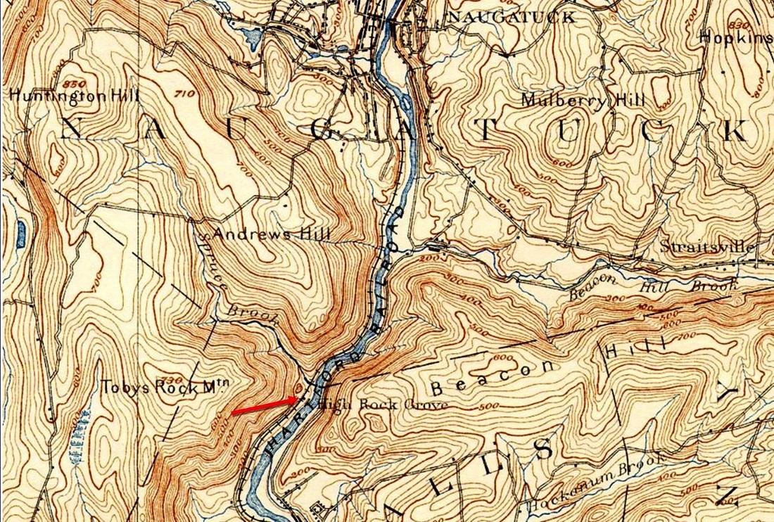
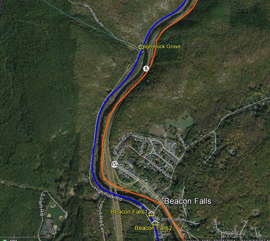
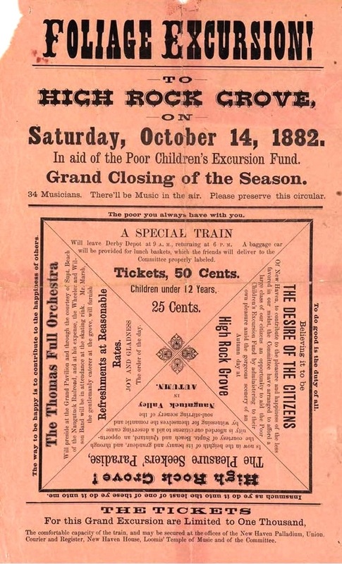
This seasonal, platform-only stop was for the NRR recreational facility that straddled the Naugatuck/Beacon Falls town line. Toby's Mountain High Rock, the crowning feature 600 feet above river level, and Spruce, aka Sherman's, Brook coursing down the adjacent gorge were natural wonders first known to Native Americans. Supt. George Wells Beach is credited with idea of opening the grove, conveniently accessible only by train, to increase patronage on regular trains and stimulate interest in special train excursions by large groups. This kind of entrepreneurship was akin to the NLN's THAMES GROVE (1870), the HRR's PARLOR ROCK (1879), and the D&N's BROOKSIDE PARK (1880). Interestingly, Beach would retire after 52 years of celebrated railroad service in 1902, at almost 70 years of age, just when his pet project probably saw its last train. Under his direction, land was purchased from the Beacon Falls Co., possibly on both sides of the river, and use of lake above the company's dam was made. The grove itself, which lay between the track and the river was merely taken by 'occupation.' The first newspaper article we can find tells of the Waterbury Baptist Sunday School picnic in 1876 and mentions a pavilion, food vendor, rowing, croquet, and that "... crossing the dam had a great charm for many..." The article also says that this annual event had taken place, presumably here, in previous years. Over time facilities were expanded for music and dancing, archery, swings, "cozy seats in trees and other shady places," and, of course, the trail to the High Rock itself. Free use of all was provided by the railroad. A 6,500-sq ft skating rink was erected in 1882 and first used the next year. A 15-car siding is mentioned but trains of as many as 25 cars are reported to have carried groups from all directions via connecting railroads. The 1885 season reportedly brought 75,000 visitors but Beach said that the Grand Army outing of 1881 hosted an estimated 7,000 veterans in a single day. If anywhere near the truth, at the 50 passengers per car mentioned in an 1883 article, that would be an astounding 140 cars to and from the grounds, an impressive logistical achievement. The NYNH&H leased the NRR as of 4/1/1887 and continued the park operation. In 1898, this was still a flag stop for five or six daily trains each way. In 1901, the railroad announced that the park would be open for picnics but use of the buildings would be scaled back and by 1903 a newspaper said HIGH ROCK GROVE was "falling into decay for want of patronage." By 1905 several newspapers lament the passing of the grove, "long since deserted," eroded by freshets and with buildings ruined by tramps and hooligans. Trolleys would run as of 7/8/1907 on the east side of the river and even stop here but it was too late for High Rock, people then preferring the more glamorous "White Cities and Luna Parks" instead. In the opinion of one reporter, however, "none was equal in all respects to old High Rock." The 1905-1907 double-tracking eliminated what was left of the grove at river level, though the stop is still on the Official List of the latter year. And people did still come. Cleveland's Plain Dealer reported in 1907 that the New York Tree Club headed north from BEACON FALLS and established the aerial, arboreal dwellings known as Tree Town on Randall Gillette's farm which backed up to the grove. The image at [1] shows a southbound NRR train approaching the station as boaters frolic. The 5/12/1879 timetable at [2] is the first we have after 1875 to show this stop. The 1886 brochure at [3] speaks of "Romantic and Weird-like Scenery" and the 1880 illustration at [4] shows a walkway bridge across the gorge. Our red arrow on the Derby northeast quadrangle topo map at [5] shows the stop in 1893 and the snippet from our Track 11 Google Earth map places it today. The advertising sheet at [7] shows the NH&D and the NRR having halted their bickering and cooperating in an end-of-season foliage tour for 'poor' city kids in 1882. All of this begs for a map of just where everything was situated and a comprehensive history of this operation in a place that is still a feast of Nature today. Click here for an informative Naugatuck Patch article by Terri Takacs. [REFS: 5/24/1875TT: no; WA/08/24/1876/03; CHS/07/04/1877/04; NHER/06/05/1879/02; CWN/07/02/1879/04 incorrectly says GWB is owner; HDC/06/21/1880/02; HDC/06/03/1881/02; NHER/07/07/1882 /04; HDC/07/20/1883/02; NYNHH rev7/18/1898TT: yes; NDN/06/15/1901/00; PTH 06/1900TT: yes; NYNHH 1902TT: yes; HC/07/23/1902/09; WEC/07/24/1903/08; TR/07/23/1904/02; NYNHH 10/1904TT: no; NH/05/18/1905/06; NDN/07/00/1905/00: could not find; CPD/07/14/1907/01; OL33 (8/1/1907): yes; Leuchars, Naugatuck Stories and Legends, p44+][rev072815, 111018, 103021]
This seasonal, platform-only stop was for the NRR recreational facility that straddled the Naugatuck/Beacon Falls town line. Toby's Mountain High Rock, the crowning feature 600 feet above river level, and Spruce, aka Sherman's, Brook coursing down the adjacent gorge were natural wonders first known to Native Americans. Supt. George Wells Beach is credited with idea of opening the grove, conveniently accessible only by train, to increase patronage on regular trains and stimulate interest in special train excursions by large groups. This kind of entrepreneurship was akin to the NLN's THAMES GROVE (1870), the HRR's PARLOR ROCK (1879), and the D&N's BROOKSIDE PARK (1880). Interestingly, Beach would retire after 52 years of celebrated railroad service in 1902, at almost 70 years of age, just when his pet project probably saw its last train. Under his direction, land was purchased from the Beacon Falls Co., possibly on both sides of the river, and use of lake above the company's dam was made. The grove itself, which lay between the track and the river was merely taken by 'occupation.' The first newspaper article we can find tells of the Waterbury Baptist Sunday School picnic in 1876 and mentions a pavilion, food vendor, rowing, croquet, and that "... crossing the dam had a great charm for many..." The article also says that this annual event had taken place, presumably here, in previous years. Over time facilities were expanded for music and dancing, archery, swings, "cozy seats in trees and other shady places," and, of course, the trail to the High Rock itself. Free use of all was provided by the railroad. A 6,500-sq ft skating rink was erected in 1882 and first used the next year. A 15-car siding is mentioned but trains of as many as 25 cars are reported to have carried groups from all directions via connecting railroads. The 1885 season reportedly brought 75,000 visitors but Beach said that the Grand Army outing of 1881 hosted an estimated 7,000 veterans in a single day. If anywhere near the truth, at the 50 passengers per car mentioned in an 1883 article, that would be an astounding 140 cars to and from the grounds, an impressive logistical achievement. The NYNH&H leased the NRR as of 4/1/1887 and continued the park operation. In 1898, this was still a flag stop for five or six daily trains each way. In 1901, the railroad announced that the park would be open for picnics but use of the buildings would be scaled back and by 1903 a newspaper said HIGH ROCK GROVE was "falling into decay for want of patronage." By 1905 several newspapers lament the passing of the grove, "long since deserted," eroded by freshets and with buildings ruined by tramps and hooligans. Trolleys would run as of 7/8/1907 on the east side of the river and even stop here but it was too late for High Rock, people then preferring the more glamorous "White Cities and Luna Parks" instead. In the opinion of one reporter, however, "none was equal in all respects to old High Rock." The 1905-1907 double-tracking eliminated what was left of the grove at river level, though the stop is still on the Official List of the latter year. And people did still come. Cleveland's Plain Dealer reported in 1907 that the New York Tree Club headed north from BEACON FALLS and established the aerial, arboreal dwellings known as Tree Town on Randall Gillette's farm which backed up to the grove. The image at [1] shows a southbound NRR train approaching the station as boaters frolic. The 5/12/1879 timetable at [2] is the first we have after 1875 to show this stop. The 1886 brochure at [3] speaks of "Romantic and Weird-like Scenery" and the 1880 illustration at [4] shows a walkway bridge across the gorge. Our red arrow on the Derby northeast quadrangle topo map at [5] shows the stop in 1893 and the snippet from our Track 11 Google Earth map places it today. The advertising sheet at [7] shows the NH&D and the NRR having halted their bickering and cooperating in an end-of-season foliage tour for 'poor' city kids in 1882. All of this begs for a map of just where everything was situated and a comprehensive history of this operation in a place that is still a feast of Nature today. Click here for an informative Naugatuck Patch article by Terri Takacs. [REFS: 5/24/1875TT: no; WA/08/24/1876/03; CHS/07/04/1877/04; NHER/06/05/1879/02; CWN/07/02/1879/04 incorrectly says GWB is owner; HDC/06/21/1880/02; HDC/06/03/1881/02; NHER/07/07/1882 /04; HDC/07/20/1883/02; NYNHH rev7/18/1898TT: yes; NDN/06/15/1901/00; PTH 06/1900TT: yes; NYNHH 1902TT: yes; HC/07/23/1902/09; WEC/07/24/1903/08; TR/07/23/1904/02; NYNHH 10/1904TT: no; NH/05/18/1905/06; NDN/07/00/1905/00: could not find; CPD/07/14/1907/01; OL33 (8/1/1907): yes; Leuchars, Naugatuck Stories and Legends, p44+][rev072815, 111018, 103021]
HIGH STREET (JUNCTION) [> COLLINSVILLE2,4]
HINCHCLIFF BRIDGE [> JERICHO]
HITCHCOCKS [> MILLDALE]
HOADLEYS [> GREYSTONE]
HOBARTS [NY&NE, c1881]
This was a passenger stop on some timetables after 1881 at the junction of the HRR and NY&NE in Brookfield.
HOP BROOK [> UNION CITY/W]
HINCHCLIFF BRIDGE [> JERICHO]
HITCHCOCKS [> MILLDALE]
HOADLEYS [> GREYSTONE]
HOBARTS [NY&NE, c1881]
This was a passenger stop on some timetables after 1881 at the junction of the HRR and NY&NE in Brookfield.
HOP BROOK [> UNION CITY/W]

|

|

|

HOP RIVER [HP&F, 1849]
This stop in the town of Coventry was established in 1849 by the HP&F. There may have been an older depot here prior to this large structure. The 3/15/1939 addendum to the SSRR list shows the passenger station, section house and coal house all rented to the Vanco Co. and later (6/19/1940) for sale. It has from that time and still now sits opposite 850 Hop River Rd, having been moved east 1/10th of a mile in the late 1950's by the Johnson family. A recent site visit showed it to be in stable condition, ripe for rehabilitation at the Connecticut Eastern Railway Museum if that ever should come to pass. The right corner bay window proudly proclaims its heritage and the side staircase to the second floor is still in evidence. [REFS: NHDP/02/13/1879/04; R60][rev010318]
This stop in the town of Coventry was established in 1849 by the HP&F. There may have been an older depot here prior to this large structure. The 3/15/1939 addendum to the SSRR list shows the passenger station, section house and coal house all rented to the Vanco Co. and later (6/19/1940) for sale. It has from that time and still now sits opposite 850 Hop River Rd, having been moved east 1/10th of a mile in the late 1950's by the Johnson family. A recent site visit showed it to be in stable condition, ripe for rehabilitation at the Connecticut Eastern Railway Museum if that ever should come to pass. The right corner bay window proudly proclaims its heritage and the side staircase to the second floor is still in evidence. [REFS: NHDP/02/13/1879/04; R60][rev010318]
HOPKINS [> SOUTH WILTON]
|
|
|
|

|

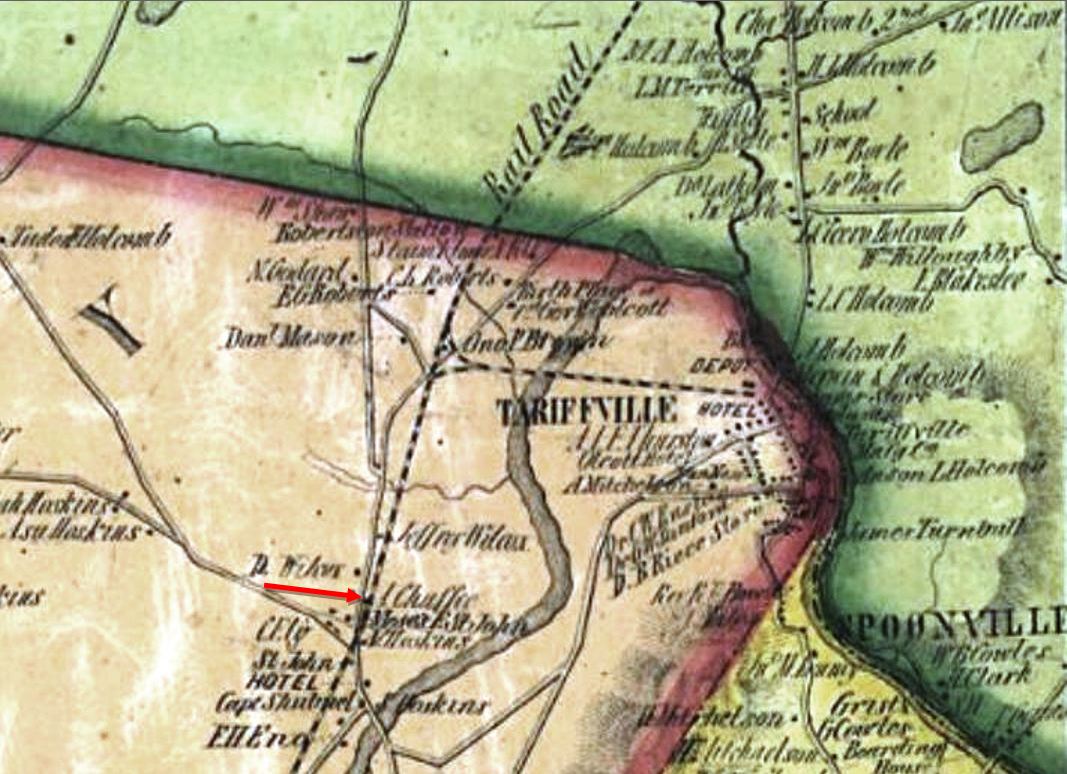
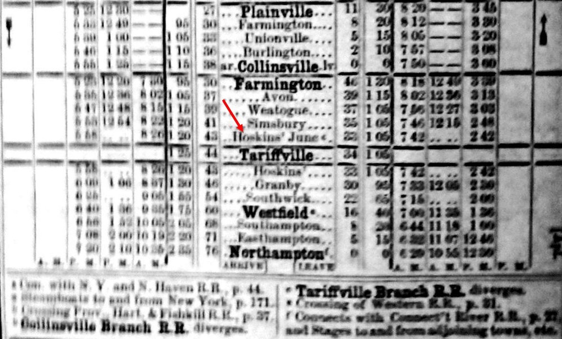
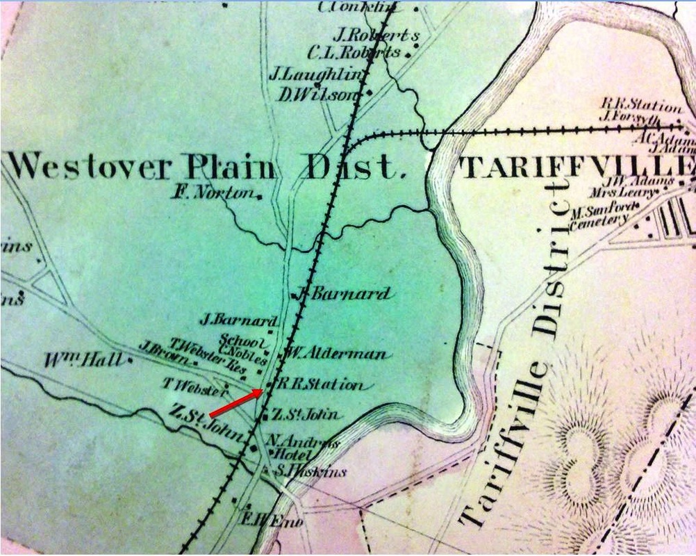
HOSKINS1 [NH&N, 1850; opens as WESTOVER]
We do not know when the structure seen at [1] was built but it possibly dates back near to 1850 when this stop in the town of Simsbury was first known as WESTOVER. At that time the Canal line extended trackage from its original PLAINVILLE terminus to GRANBY and opened branches to COLLINSVILLE and TARIFFVILLE. Thus was born HOSKINS JUNCTION, footnoted on the 1859 timetable at [3] as the point where the "Tariffville Branch R.R. diverges." With no turntable at the end of the branch in the latter place, the railroad apparently built a wye here, seen on the 1855HC map at [2], to enable trains to back into Tariffville. HOSKINS station, however, whenever it appeared, was almost a mile south. Our red arrow shows no depot on the 1855 map but the 1869 map at [4] shows the station in place on the west side of the track at Ely Rd. When the CW opened their line in 1871, they did not purchase the Canal line's Tariffville Branch, as some have claimed, but rather built a new right of way down to HOSKINS station. A 10/18/1871 newspaper article reports that from here to Simsbury "... the Connecticut Western takes the road-bed of the Canal road, shifting the latter track to a new road-bed..." and another piece says the two roads were separated only by 25 feet as they paralleled each other, the Canal line on the west, to SIMSBURY where a diagonal crossing was made for the CW to head for Millerton, NY. The 1892 topo map at [5] seems to err in showing the two rail lines crossing here but it does place the depot properly on the east side of the CW track as later photos and maps show it. We know from other sources that the NH&N's TARIFFVILLE1 station was rented about this time for use by the CW and it might also be that the Canal line rented out HOSKINS as well or gave it up completely to the CW which moved it south from Ely to Hoskins Rd and to the east side of its track. The 1915 val map at [6] states that Hoskins Jct.-Tariffville trackage was abandoned in 1869 and lifted in 1870, though the ROW was still NH&N property and it would later play a role in "The Battle for Springfield." For now, the Canal line was apparently giving up on the village in the wake of the great fire at the Hartford Carpet Co. on 6/10/1867 that destroyed the community's manufacturing base and threw several hundred people out of work. The NH&N retrenchments also coincide with the expiration of the NY&NH lease in 1869 and the newly independent road's policy of streamlining operations and discontinuing flag stops like BROOKS, ALLENS, PLANTSVILLE and others. In 1880, when the NY&NE was considering a lease of the CW, they reported a freight structure here that was in good repair and worth $250. This may be the building pictured at [1] where people seem to be waiting to catch the train on a raised platform. Presumably this is also the "old shed station" that the Courant tells us was torn down in 1899 to make way for "one better fitted for the accommodation of passengers." The 12/21/1871 timetable at [7] shows HOSKINS at the opening of the CW; we have found no appearance thereafter on the Canal line. [REFS: SR/06/11/1867/02; HDC/10/01/1871/01; HDC/10/18/1871/02; CC/11/24/1871/02; SR/11/24/1871/02; 1880 CW/NYNE lease; NHER/05/29/1883/04; HC/09/04/1896/08; CWN/09/17/1896/04; SR/01/27/1897/11; HC/11/04/1899/05][rev110217]
We do not know when the structure seen at [1] was built but it possibly dates back near to 1850 when this stop in the town of Simsbury was first known as WESTOVER. At that time the Canal line extended trackage from its original PLAINVILLE terminus to GRANBY and opened branches to COLLINSVILLE and TARIFFVILLE. Thus was born HOSKINS JUNCTION, footnoted on the 1859 timetable at [3] as the point where the "Tariffville Branch R.R. diverges." With no turntable at the end of the branch in the latter place, the railroad apparently built a wye here, seen on the 1855HC map at [2], to enable trains to back into Tariffville. HOSKINS station, however, whenever it appeared, was almost a mile south. Our red arrow shows no depot on the 1855 map but the 1869 map at [4] shows the station in place on the west side of the track at Ely Rd. When the CW opened their line in 1871, they did not purchase the Canal line's Tariffville Branch, as some have claimed, but rather built a new right of way down to HOSKINS station. A 10/18/1871 newspaper article reports that from here to Simsbury "... the Connecticut Western takes the road-bed of the Canal road, shifting the latter track to a new road-bed..." and another piece says the two roads were separated only by 25 feet as they paralleled each other, the Canal line on the west, to SIMSBURY where a diagonal crossing was made for the CW to head for Millerton, NY. The 1892 topo map at [5] seems to err in showing the two rail lines crossing here but it does place the depot properly on the east side of the CW track as later photos and maps show it. We know from other sources that the NH&N's TARIFFVILLE1 station was rented about this time for use by the CW and it might also be that the Canal line rented out HOSKINS as well or gave it up completely to the CW which moved it south from Ely to Hoskins Rd and to the east side of its track. The 1915 val map at [6] states that Hoskins Jct.-Tariffville trackage was abandoned in 1869 and lifted in 1870, though the ROW was still NH&N property and it would later play a role in "The Battle for Springfield." For now, the Canal line was apparently giving up on the village in the wake of the great fire at the Hartford Carpet Co. on 6/10/1867 that destroyed the community's manufacturing base and threw several hundred people out of work. The NH&N retrenchments also coincide with the expiration of the NY&NH lease in 1869 and the newly independent road's policy of streamlining operations and discontinuing flag stops like BROOKS, ALLENS, PLANTSVILLE and others. In 1880, when the NY&NE was considering a lease of the CW, they reported a freight structure here that was in good repair and worth $250. This may be the building pictured at [1] where people seem to be waiting to catch the train on a raised platform. Presumably this is also the "old shed station" that the Courant tells us was torn down in 1899 to make way for "one better fitted for the accommodation of passengers." The 12/21/1871 timetable at [7] shows HOSKINS at the opening of the CW; we have found no appearance thereafter on the Canal line. [REFS: SR/06/11/1867/02; HDC/10/01/1871/01; HDC/10/18/1871/02; CC/11/24/1871/02; SR/11/24/1871/02; 1880 CW/NYNE lease; NHER/05/29/1883/04; HC/09/04/1896/08; CWN/09/17/1896/04; SR/01/27/1897/11; HC/11/04/1899/05][rev110217]
|
|
|
|
|
|
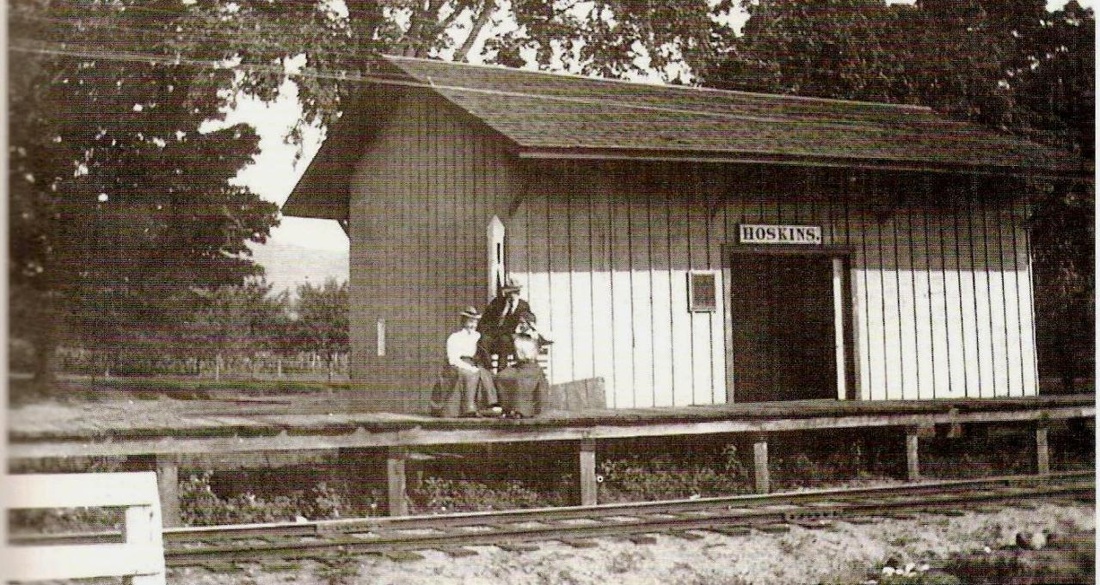
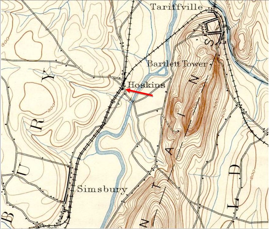
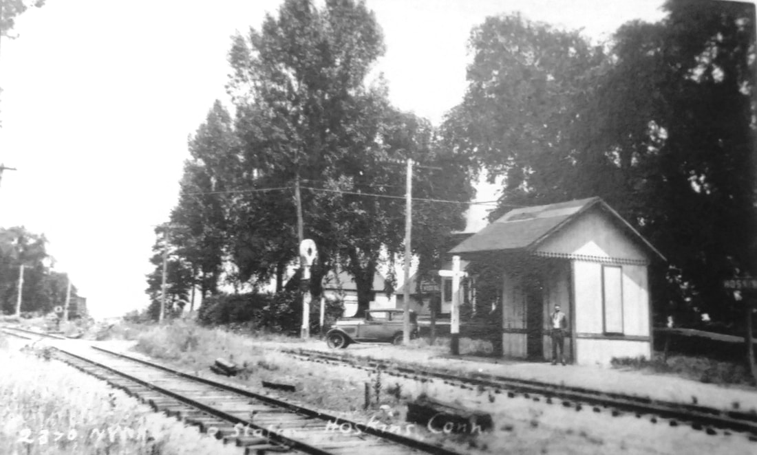
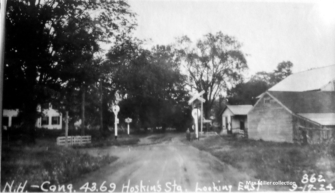
HOSKINS2 [NYNH&H, 1900]
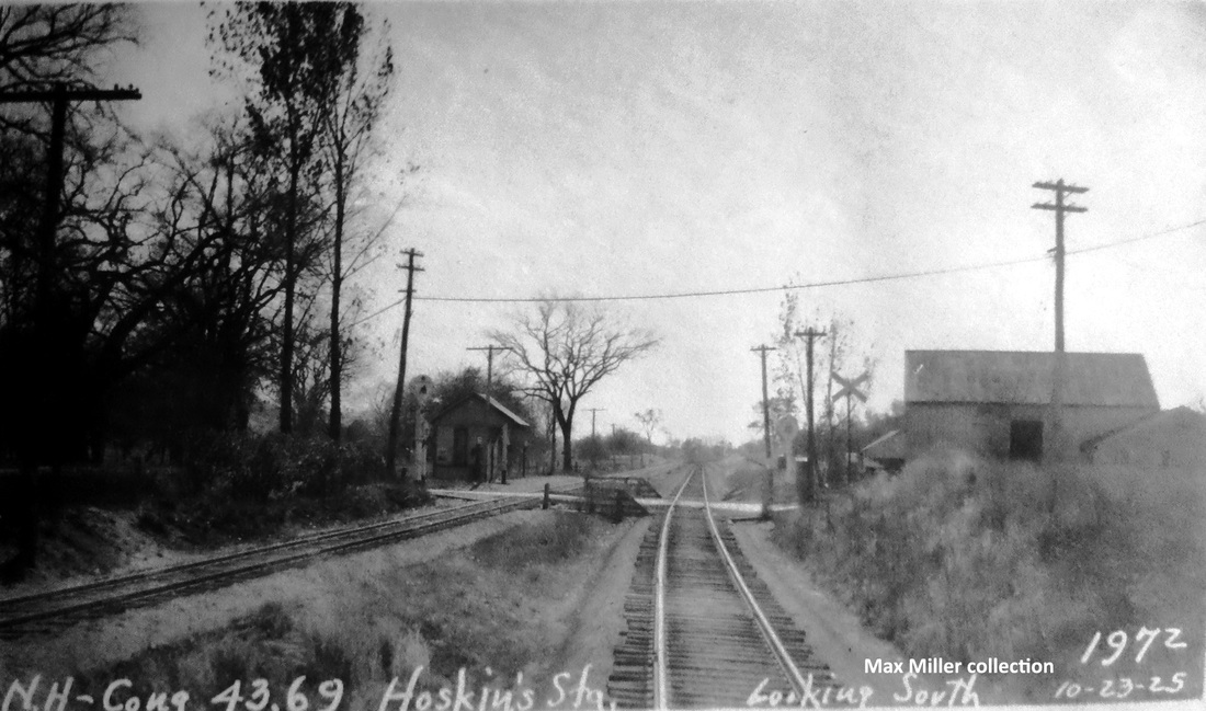
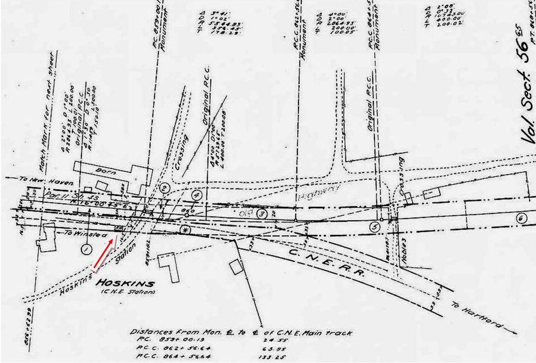
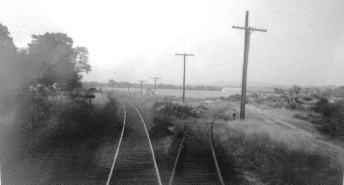
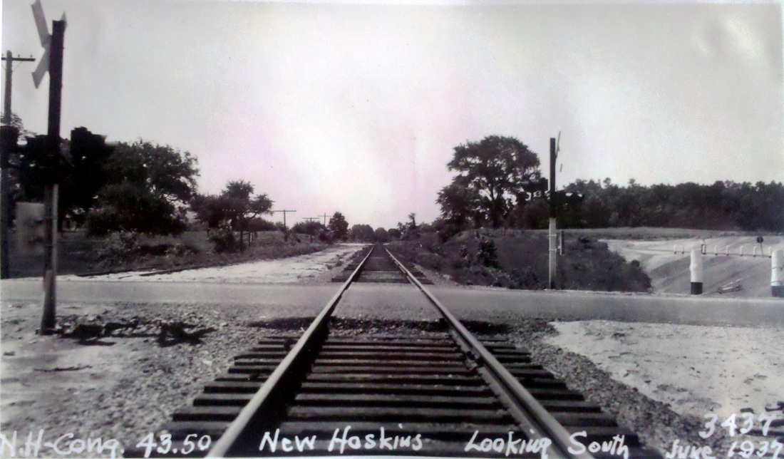
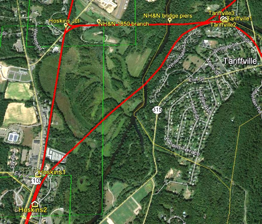
An 1899 Courant article tells us that "the old shed station at Hoskins on the line of the Central New England Railroad, the next station west of Tariffville, has been torn down and a new station, better fitted for the accommodation of passengers, is to be built. It is a flag station and the morning and evening trains always stop there. The station was formerly named Westover, which some people think was more euphonious than the present name." With the timing of the article in late 1899, we are thinking that 1900 is a better date than Nimke's 1901. The photo at [1] was taken in 1929, possibly on June 22, by Lewis H. Benton, his #2370, with chauffeur/sidekick Irving N. Drake posing and his sedan seen in the distance. The view looks northeast with the Canal line track at left and the CNE track to Tariffville at right. A box car is parked on the CNE siding beyond the switch stand. A Hall electric 'banjo' signal protects the Hoskins Rd. crossing The station window is boarded up. Passenger service ended in 1925 on the Canal line and in 1927 on the CNE but, perhaps with the humor for which the pair is known, the paddle is down to stop the train. The eastward looking PUC shot at [2] is dated 9/17/1924 and the southward view at [3] was taken on 10/29/1925. The 1915 val map at [4] shows the location of HOSKINS2 at our red arrow. The shot at [5] looks north from just above the crossing, Canal track on the left, CNE on the right. The June, 1937 PUC photo at [6] looks south with the CNE track on the left now severed. The 'New Hoskins Crossing' is today's Rte 315 and this was part of the 1936 realignment of Rte. 10 to the west of the railroad from here down to Westminster School. The CNE from Simsbury to Tariffville was abandoned that year. The snippet from our Track 11 Google Earth map shows the locations of HOSKINS1, HOSKINS2 and HOSKINS JUNCTON in relation to TARIFFVILLE. [REFS: HC/11/04/1899/05; K114; N3.18][rev102017]
An 1899 Courant article tells us that "the old shed station at Hoskins on the line of the Central New England Railroad, the next station west of Tariffville, has been torn down and a new station, better fitted for the accommodation of passengers, is to be built. It is a flag station and the morning and evening trains always stop there. The station was formerly named Westover, which some people think was more euphonious than the present name." With the timing of the article in late 1899, we are thinking that 1900 is a better date than Nimke's 1901. The photo at [1] was taken in 1929, possibly on June 22, by Lewis H. Benton, his #2370, with chauffeur/sidekick Irving N. Drake posing and his sedan seen in the distance. The view looks northeast with the Canal line track at left and the CNE track to Tariffville at right. A box car is parked on the CNE siding beyond the switch stand. A Hall electric 'banjo' signal protects the Hoskins Rd. crossing The station window is boarded up. Passenger service ended in 1925 on the Canal line and in 1927 on the CNE but, perhaps with the humor for which the pair is known, the paddle is down to stop the train. The eastward looking PUC shot at [2] is dated 9/17/1924 and the southward view at [3] was taken on 10/29/1925. The 1915 val map at [4] shows the location of HOSKINS2 at our red arrow. The shot at [5] looks north from just above the crossing, Canal track on the left, CNE on the right. The June, 1937 PUC photo at [6] looks south with the CNE track on the left now severed. The 'New Hoskins Crossing' is today's Rte 315 and this was part of the 1936 realignment of Rte. 10 to the west of the railroad from here down to Westminster School. The CNE from Simsbury to Tariffville was abandoned that year. The snippet from our Track 11 Google Earth map shows the locations of HOSKINS1, HOSKINS2 and HOSKINS JUNCTON in relation to TARIFFVILLE. [REFS: HC/11/04/1899/05; K114; N3.18][rev102017]
HOUGHS MILL [> CHESHIRE STREET]
HUMPHREYSVILLE [> SEYMOUR]
HUNTINGTON [> SHELTON]
INCHCLIFF BRIDGE [> JERICHO]
IVES1,2 [> MOUNT CARMEL2,3]
HUMPHREYSVILLE [> SEYMOUR]
HUNTINGTON [> SHELTON]
INCHCLIFF BRIDGE [> JERICHO]
IVES1,2 [> MOUNT CARMEL2,3]

|

|
JERICHO [NRR, 1849]
This is somewhat obscure and we do not know if it was an actual stop in the town of Thomaston. The only place we have seen it is on what is probably an employee timetable of 6/15/1908 in Connecticut Railroads [p89], where it is put 1.23 miles south of REYNOLDS BRIDGE. There has been a railroad bridge here from the opening of the NRR and in 1852 it was the site of a derailment attempt. The 1854LC map at left presents the area at almost that exact time but no station is indicated. This may be synonomous with (H)Inchcliff Bridge which was the NRR's terminus for a short while during its construction north from Waterbury. An 1849 newspaper article says "grand rail road excursion" trains on July 4th would be running from here to Bridgeport and New Haven. [REFS: RF/06/26/1849/03; HC/09/06/1852/02][rev022513]
This is somewhat obscure and we do not know if it was an actual stop in the town of Thomaston. The only place we have seen it is on what is probably an employee timetable of 6/15/1908 in Connecticut Railroads [p89], where it is put 1.23 miles south of REYNOLDS BRIDGE. There has been a railroad bridge here from the opening of the NRR and in 1852 it was the site of a derailment attempt. The 1854LC map at left presents the area at almost that exact time but no station is indicated. This may be synonomous with (H)Inchcliff Bridge which was the NRR's terminus for a short while during its construction north from Waterbury. An 1849 newspaper article says "grand rail road excursion" trains on July 4th would be running from here to Bridgeport and New Haven. [REFS: RF/06/26/1849/03; HC/09/06/1852/02][rev022513]

|

|
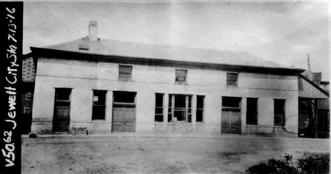
JEWETT CITY/N1 [N&W, 1840]
This stop in the town of Griswold was established in 1840 by the N&W. The 1854NL map is on the left. On the 1889 Burleigh bird's-eye map [click here] to the right, the depot is seen with the locator number '5' on the roof. [rev032213]
This stop in the town of Griswold was established in 1840 by the N&W. The 1854NL map is on the left. On the 1889 Burleigh bird's-eye map [click here] to the right, the depot is seen with the locator number '5' on the roof. [rev032213]

|

|
Dave Peters Collection
|
JEWETT CITY/N2 [NYNH&H, 1899]
[REFS: HDC/01/24/1898/11; NHER/07/01/1899/03; CRC.47.1899.31]
[REFS: HDC/01/24/1898/11; NHER/07/01/1899/03; CRC.47.1899.31]

JEWETT CITY/H [HP&F, 1854; depot, 1861]
Later called LISBON. Even though this station was established in 1854 west of the Quinebaug River in the township of Lisbon, it was called JEWETT CITY on HP&F and NY&NE timetables for the better-known manufacturing village in the township of Griswold. We have put it under this listing so as to have the original name take precedence. On many maps, the dot for the stop west of the river is unlabeled on the assumption that it will be read as coinciding with the station to the east. The RRMs actually show two separate JEWETT CITY stops. Apparently, the duplicate names were of no concern even to the NY&NE because the stops were under two different operating divisions. The official renaming of this station as LISBON is first seen in the NHAR for 1899 immediately after the NYNH&H's 1898 takeover of the NY&NE. [REFS: HPFAR12.1861.7: station built; HDC/05/07/1874/02][rev032213]
Later called LISBON. Even though this station was established in 1854 west of the Quinebaug River in the township of Lisbon, it was called JEWETT CITY on HP&F and NY&NE timetables for the better-known manufacturing village in the township of Griswold. We have put it under this listing so as to have the original name take precedence. On many maps, the dot for the stop west of the river is unlabeled on the assumption that it will be read as coinciding with the station to the east. The RRMs actually show two separate JEWETT CITY stops. Apparently, the duplicate names were of no concern even to the NY&NE because the stops were under two different operating divisions. The official renaming of this station as LISBON is first seen in the NHAR for 1899 immediately after the NYNH&H's 1898 takeover of the NY&NE. [REFS: HPFAR12.1861.7: station built; HDC/05/07/1874/02][rev032213]
National Archives
|
|
|
|
|

Ramsdell Transportation Collection
|

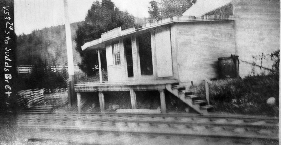
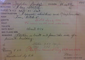
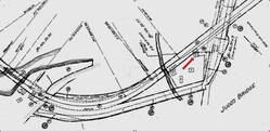
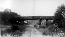
JUDDS BRIDGE [SRR, 1872, depot 1873/4]
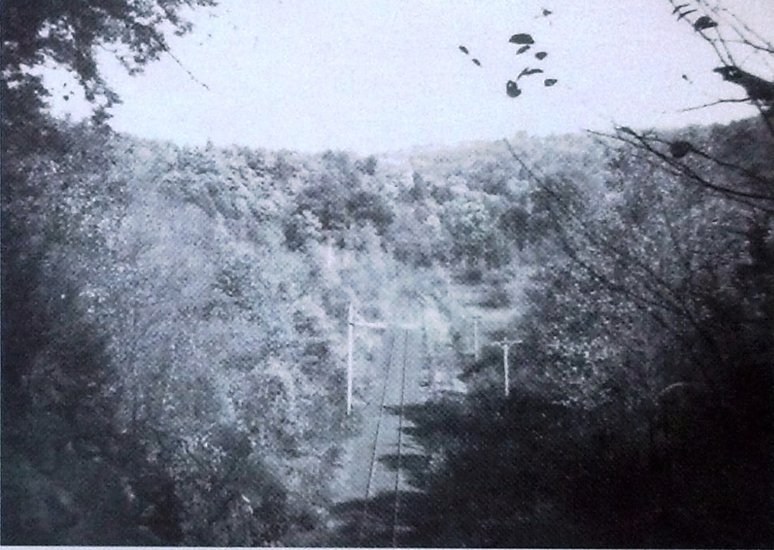
This was a flag stop established in 1872 on the Shepaug line in the town of ROXBURY. The newspaper said in August, 1874 that the railroad was building "... a new depot at Judd's Bridge for the benefit of the Stone company, which is opening a quarry of granite at that place. Stone, dairy products and farm crops were, of course, the staple of this brave little rural railroad which was always in financial distress. The real estate card gives dimensions and a sketch and says the station was sold on 1/6/1940 but was to remain on land leased by the railroad company. The platform was removed in 1938 through Authorization for Expenditure (AFE) 31456.
IMAGES: [1] 10/9/1915 valuation photo; [2,3] 1911 real estate card; [[4] 6/30/1915 valuation map, orientation north to the left. Station at our red arrow; [5] 10/15/1929 PUC photo looking north at highway bridge just south of station; The shot at [6] is pf a four-car derailment on 3/28/1912 which threw fours cars of a southbound freight into the Shepaug River on the bridge crossing just south of the station. An out-of-service bridge, a circuitous journey, and a chance encounter a decade or so ago led us to discover that this depot was extant, as seen at [7], and still in use as part of a residence. This structure is neither in John Roy's book nor on the Railroad Station Historical Society's list of extant Connecticut railroad stations. REFERENCES: HDC/08/08/1873/04: depot built; CWN/08/21/1874/02; R61: no. TCS REVISIONS: 6/24/2022.
Washington Historical Society
|
Washington Historical Society
|
|
 Steep Rock Association
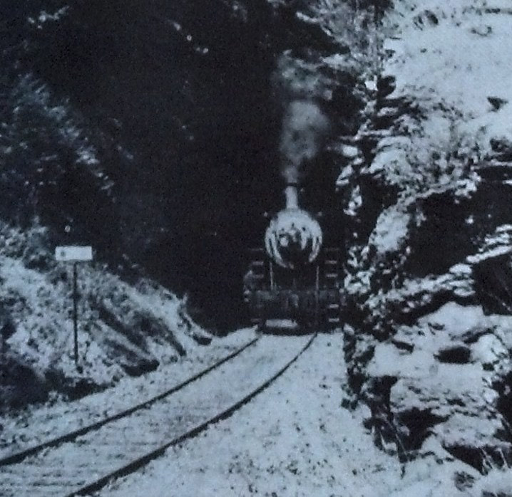
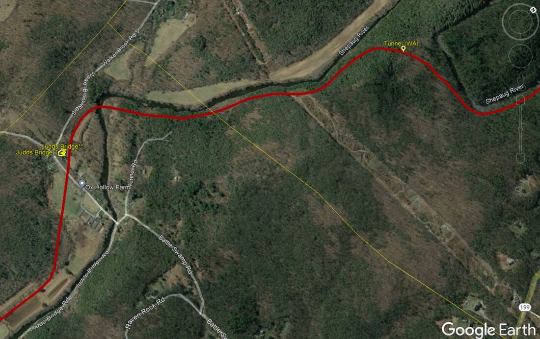
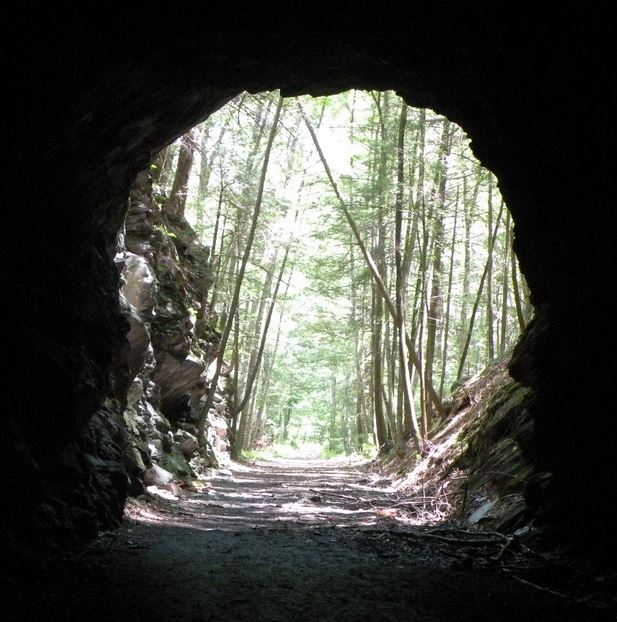
Given the legendary circuitousness of the Shepaug following the undulations of its namesake river, the famed tunnel is to the north of JUDDS BRIDGE and halfway to VALLEY STATION. The newspaper said in 1871 that the 240-ft Washington tunnel was expected to be completed by September 1. The unadorned plain bore was in service by 12/22/1871 when the state railroad commissioners rode the line to inspect it. The shot at [1] shows a train emerging from the south portal, likely headed by old reliable NH 372. The photo at [2] looks out at the north portal. The Track 12 Google Earth map snippet at [3] shows the location of the tunnel on, of course, Tunnel Rd. The image at [4] shows the tunnel today which draws crowds, especially folks seeking cool relief from the summer heat REFERENCES: 05/06/1871/04; LEN/12/28/1871/03. TCS REVISIONS: 6/24/2022.
Dave Peters Collection
|
|
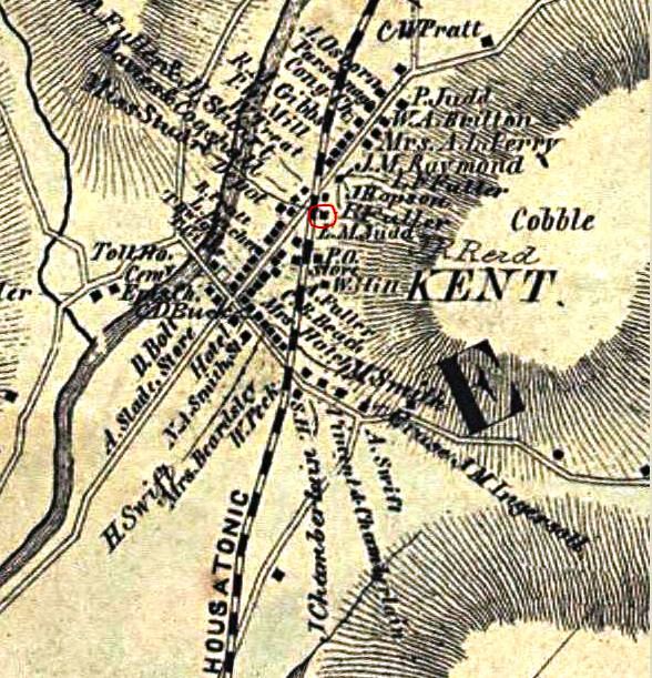
KENT/H1 [HRR, 1842, as KENT PLAINS]
This was the first location of a station in the town of KENT when the HRR built to the state line in 1842. According to John Roy [p61], it was in the Kent Plains Hotel that was about 200 feet south of the present station, our KENT/H2. The 1854LC map shows where the original station was. [REFS: D72; R61]
This was the first location of a station in the town of KENT when the HRR built to the state line in 1842. According to John Roy [p61], it was in the Kent Plains Hotel that was about 200 feet south of the present station, our KENT/H2. The 1854LC map shows where the original station was. [REFS: D72; R61]
Max Miller Collection
|
|
|
 Edward J. Ozog Collection
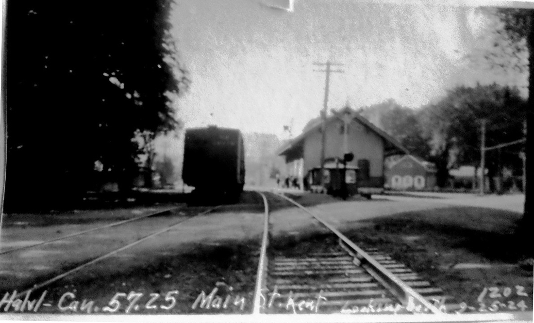
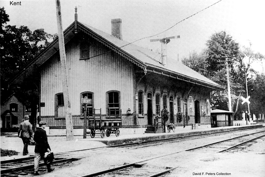
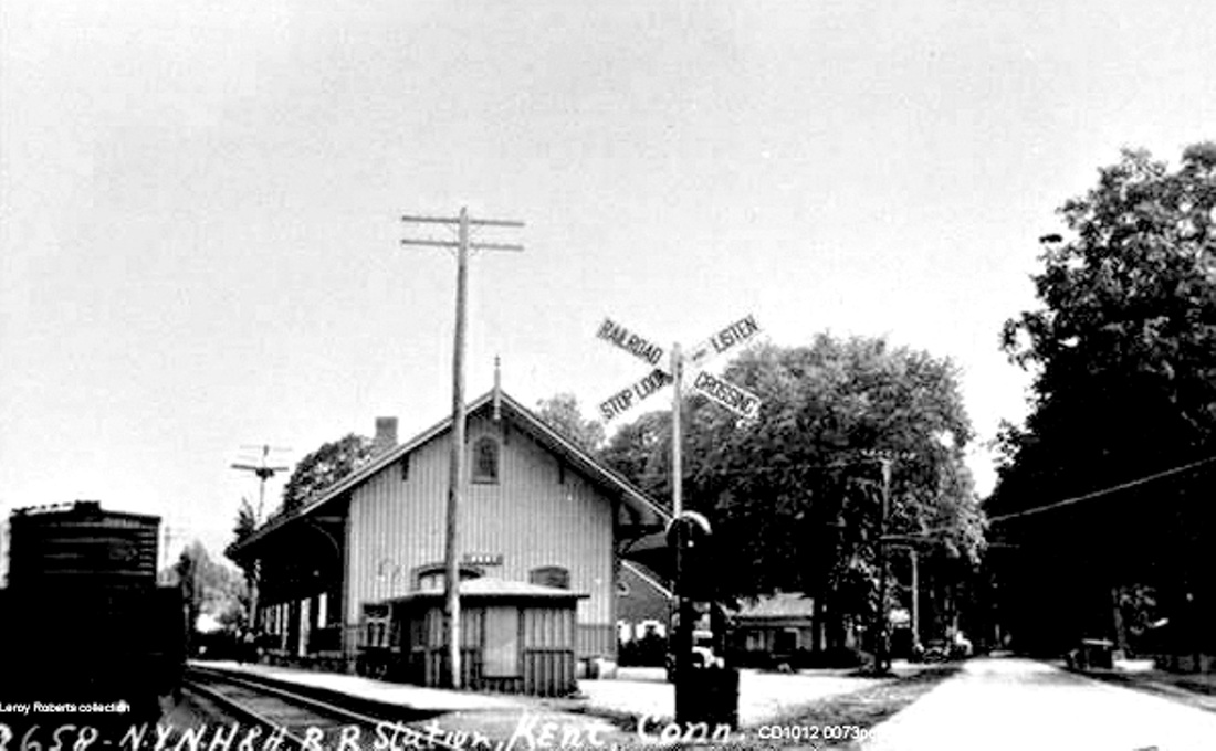
KENT/H2 [HRR, 1874]
By the 1870s the railroad decided to abandon KENT1 at the Kent Plains Hotel and build its own depot. If you follow all the newspaper accounts, the progress toward this goal was unbelievably slow, starting in July, 1872 when the paper said "The H.R.R. Co. have commenced work on their new depot in this place, and have begun in earnest. The first of August will see the structure all in running order, a thing long needed." Indeed! Later reports told of the foundation not being laid until April, 1873 and it was a year and a half more before Middletown's Daily Constitution said that it was almost completed at a cost of between $5,000 and $6,000. The Connecticut Western News gave the final appraisal in January, 1875, saying that the depot was one of the finest on the Housatonic road... "an ample structure and elaborately finished, being provided with everything that can in any wise conduce to the convenience and comfort of the patrons of the road and its business. We congratulate Agent Smith on his new and elegant quarters." The railroad commissioners also mention its completion in their next annual report. This venerable structure still stands today as a town landmark. The PUC photo at [1] is dated 9/25/1924. The order boards are down for trains in both directions in the shot at [2]. The Lewis H. Benton ca. 1930 image at [3] shows Irving Drake's sedan . The postcard at [4], interestingly, was mailed from a mother in Kent to her daughter in New York City on 11/19/1955. As Ed Ozog points out, this was five years after steam was gone. Someone thought the card, which was either still for sale as a nostalgia piece or had been purchased years before, was worth holding on to and sending at this point. The "this way to New York" notation adds a personal touch to a the handsome photo of a powerful I-2 Pacific at a rural Connecticut country depot. [REFS: CWN/06/14/1872/02; CWN/06/21/1872/02; CWN/04/11/1873/02; HDC/04/15/1873/04; HDC/09/30/1874/02; DC/11/11/1874/03; CRC22.1875.34; D73; CWN/01/29/ 1875/02; HRR 1875AR, p3; R61][rev070315]
By the 1870s the railroad decided to abandon KENT1 at the Kent Plains Hotel and build its own depot. If you follow all the newspaper accounts, the progress toward this goal was unbelievably slow, starting in July, 1872 when the paper said "The H.R.R. Co. have commenced work on their new depot in this place, and have begun in earnest. The first of August will see the structure all in running order, a thing long needed." Indeed! Later reports told of the foundation not being laid until April, 1873 and it was a year and a half more before Middletown's Daily Constitution said that it was almost completed at a cost of between $5,000 and $6,000. The Connecticut Western News gave the final appraisal in January, 1875, saying that the depot was one of the finest on the Housatonic road... "an ample structure and elaborately finished, being provided with everything that can in any wise conduce to the convenience and comfort of the patrons of the road and its business. We congratulate Agent Smith on his new and elegant quarters." The railroad commissioners also mention its completion in their next annual report. This venerable structure still stands today as a town landmark. The PUC photo at [1] is dated 9/25/1924. The order boards are down for trains in both directions in the shot at [2]. The Lewis H. Benton ca. 1930 image at [3] shows Irving Drake's sedan . The postcard at [4], interestingly, was mailed from a mother in Kent to her daughter in New York City on 11/19/1955. As Ed Ozog points out, this was five years after steam was gone. Someone thought the card, which was either still for sale as a nostalgia piece or had been purchased years before, was worth holding on to and sending at this point. The "this way to New York" notation adds a personal touch to a the handsome photo of a powerful I-2 Pacific at a rural Connecticut country depot. [REFS: CWN/06/14/1872/02; CWN/06/21/1872/02; CWN/04/11/1873/02; HDC/04/15/1873/04; HDC/09/30/1874/02; DC/11/11/1874/03; CRC22.1875.34; D73; CWN/01/29/ 1875/02; HRR 1875AR, p3; R61][rev070315]
KENT/D [> SOUTH WILTON]
KENT FURNACE [> NORTH KENT]
KENT FURNACE [> NORTH KENT]
|

|
KENT ROAD [PC, 1978]
This WILTON station was just below the old SOUTH WILTON, aka KENT, depot and reportedly opened in January of 1976 for employees of Perkin Elmer. This belated accommodation was in the Penn Central era just before the creation of Conrail. Cornwall says two daily trains each way were still making this stop in 1986 and serving a few riders. Growing traffic congestion on Rte. 7 had already persuaded the optics company to build a new plant in Danbury in 1966 rather than expanding the one here and the trend continued until Metro North, according to a Wilton Bulletin article, moved to discontinue service here as of 1/16/1994. The railroad said that ridership had dwindled to 15 passengers per day and a newly refurbished MERRITT 7 station, 1.2 miles to the south, was expected to serve instead, with CDOT running van shuttles between the two locations for at least the next six months. Many thanks to Dave Sullivan for sending in an article that sheds light on two stations at once! The shot on the left looks north and the one on the right looks south with the parking area on the east side of the track and shelter. [REFS: HC/10/30/1966/8A; WB/01/12/1994/02; P103]
This WILTON station was just below the old SOUTH WILTON, aka KENT, depot and reportedly opened in January of 1976 for employees of Perkin Elmer. This belated accommodation was in the Penn Central era just before the creation of Conrail. Cornwall says two daily trains each way were still making this stop in 1986 and serving a few riders. Growing traffic congestion on Rte. 7 had already persuaded the optics company to build a new plant in Danbury in 1966 rather than expanding the one here and the trend continued until Metro North, according to a Wilton Bulletin article, moved to discontinue service here as of 1/16/1994. The railroad said that ridership had dwindled to 15 passengers per day and a newly refurbished MERRITT 7 station, 1.2 miles to the south, was expected to serve instead, with CDOT running van shuttles between the two locations for at least the next six months. Many thanks to Dave Sullivan for sending in an article that sheds light on two stations at once! The shot on the left looks north and the one on the right looks south with the parking area on the east side of the track and shelter. [REFS: HC/10/30/1966/8A; WB/01/12/1994/02; P103]
|
University of Vermont Spec. Colls.
|
|
|
|
|
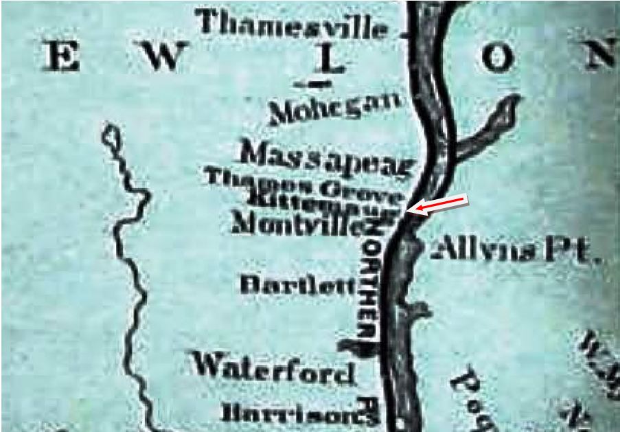
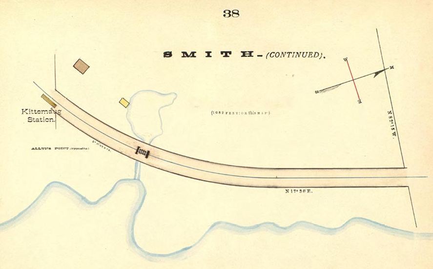
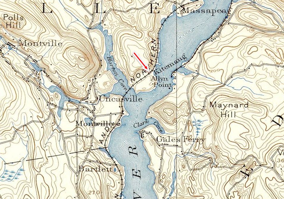
KITEMAUG1 [NLN, 1879]
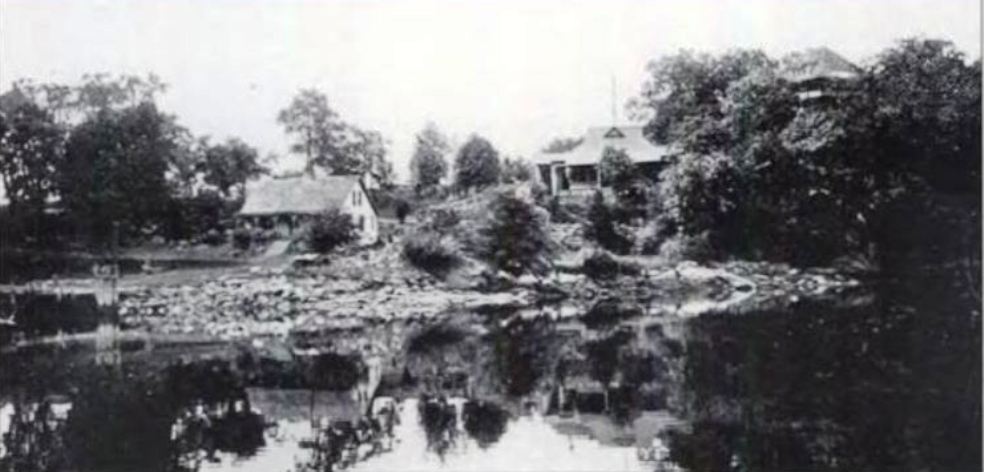
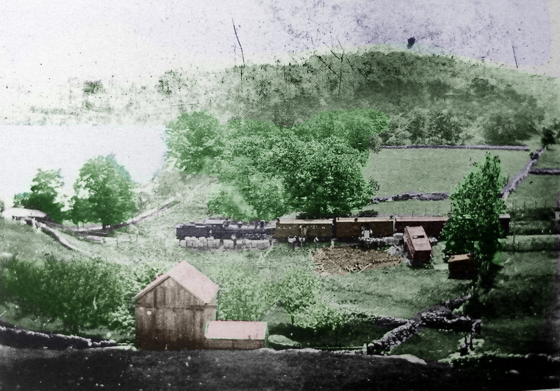
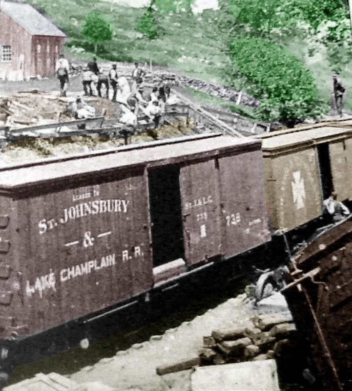
This Montville flag stop, seven miles north of NEW LONDON, appears to date to when the Kitemaug Association was chartered "for the purpose of culture" and the group purchased Smith's Grove. The name of the peninsular locale means "great fishing place" in the Algonquian language. The stop begins to appear on RRMs in 1881 [1], although the chosen spelling there is with two Ts. The 1883 NLN railroad atlas [2], in fact, shows the name Smith associated with the property and indicates where the platform sat. The 1893 topo map [3] also shows the stop, with no highway access at that time. Prizing this very remoteness, club members and their guests came by train to this isolated spot to meet, socialize, and recreate. An 1893 newspaper article noted that part of the attraction here was the rocky granite outcropping called "Uncas' chair," an "aboriginal piece of furniture," where the chief reportedly sat communing with the gods and awaiting news from the battlefield. The association structures are seen in photo [4]: the club house on the hill and the caretaker's cottage and dining hall on the lower grounds where private launches and the excursion steamer Ella would dock. The facilities were used to host business gatherings, political confabs, and social events at the widely known, fashionable resort. The group's heyday passed in the late 1890s, the property was sold, and the clubhouse burned in 1915, reportedly in a fire sparked by a passing locomotive. Shots [5] and [6] are credited to the long-lived Marvin Smith who photographed a pre-1900 train wreck adjacent to his farm. Image [5] looks east and the platform is probably behind the locomotive. [REFS: HDC/06/09/1879/04; NHER/09/25/1879/04; HDC/08/02/1880/02; NHER/08/06/1880/04; NHER/08/26/1880/04; NHER/09/26/1882/04; NHER/11/19/1884/01; NHER/06/26/1893/07; RRM1882-1912; GHD1886-1913; RAM 1916-1926; K101] [rev012014]
This Montville flag stop, seven miles north of NEW LONDON, appears to date to when the Kitemaug Association was chartered "for the purpose of culture" and the group purchased Smith's Grove. The name of the peninsular locale means "great fishing place" in the Algonquian language. The stop begins to appear on RRMs in 1881 [1], although the chosen spelling there is with two Ts. The 1883 NLN railroad atlas [2], in fact, shows the name Smith associated with the property and indicates where the platform sat. The 1893 topo map [3] also shows the stop, with no highway access at that time. Prizing this very remoteness, club members and their guests came by train to this isolated spot to meet, socialize, and recreate. An 1893 newspaper article noted that part of the attraction here was the rocky granite outcropping called "Uncas' chair," an "aboriginal piece of furniture," where the chief reportedly sat communing with the gods and awaiting news from the battlefield. The association structures are seen in photo [4]: the club house on the hill and the caretaker's cottage and dining hall on the lower grounds where private launches and the excursion steamer Ella would dock. The facilities were used to host business gatherings, political confabs, and social events at the widely known, fashionable resort. The group's heyday passed in the late 1890s, the property was sold, and the clubhouse burned in 1915, reportedly in a fire sparked by a passing locomotive. Shots [5] and [6] are credited to the long-lived Marvin Smith who photographed a pre-1900 train wreck adjacent to his farm. Image [5] looks east and the platform is probably behind the locomotive. [REFS: HDC/06/09/1879/04; NHER/09/25/1879/04; HDC/08/02/1880/02; NHER/08/06/1880/04; NHER/08/26/1880/04; NHER/09/26/1882/04; NHER/11/19/1884/01; NHER/06/26/1893/07; RRM1882-1912; GHD1886-1913; RAM 1916-1926; K101] [rev012014]
|
|
|
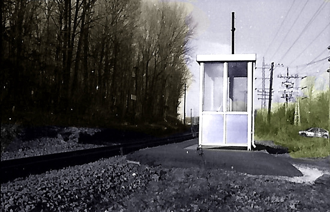
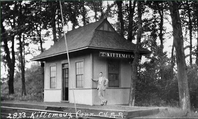
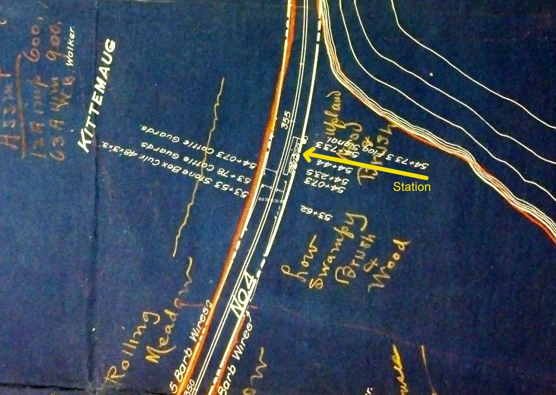
KITEMAUG2 [CVT, 1913]
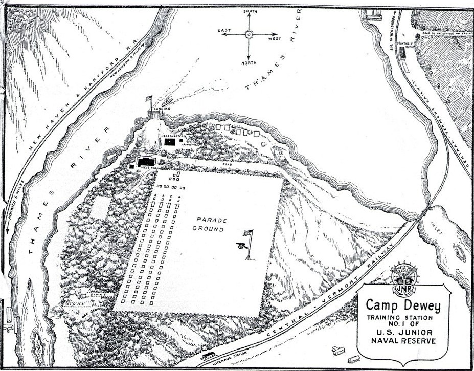
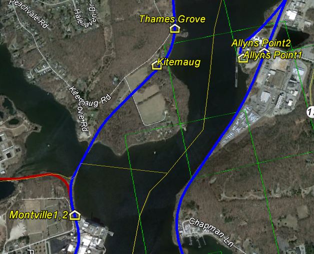
Through the diligent research of local Kitemaug resident and historian, Deanna Lang, we now learn that this fashionable little structure was built in 1912 to replace the platform that had served in prior years. The New London Day of 7/16/1913 reads as follows: "Kitemaug Station Has Been Completed. Central Vermont patrons appreciate improvement that has been made. The new Central Vermont station at Kitemaug has been completed and was used for the first time Monday [7/10/1913]. It is of attractive appearance, painted two shades of brown and has a flaring roof on all sides. It has one large waiting room with numerous benches. Howard Beetham of Montville has been appointed station agent. The new station was built to accommodate the increasing amount of business at this point on the line. More tickets are sold at Kitemaug than at any other place between Norwich and New London. Heretofore there is only been a platform there." So in one fell swoop, we learn that this was a busy little station and had an agent, at least for a time, to serve visitors to the association and also the large number of cottagers who came from as far as Springfield to spend the summers here. In 1916 and 1917 Camp Dewey, a U.S. Junior Naval Reserve facility, used the property, training as many as 300 young men for naval and merchant marine service. Always a desirable locale, Kitemaug was popular viewing point for river racing competitions and a Norwich boating club ran regattas from here in the late 1920s. Photo [1] is a Lewis H. Benton shot from the 1930s, Irving N. Drake posing. The latter's sedan, usually seen in these photos, must be parked out of sight. The station building looks well cared for even at this time, long after politicians, businessmen, and student sailors ceased frequenting the grounds. Al Weaver's yellow arrow, above which it says 'Flag Station', on the 1917 val map [2] shows the location. Inexplicably there is no station footprint; only a platform is shown. The map at [3] shows the grounds as Camp Dewey. Also seen on the map are both the MONTVILLE and KITEMAUG stations, as well as the PALMERTOWN branch track at the far left. The snippet at [4] is from our Track 11 Google Earth map and shows the area today. KITEMAUG is last seen on a 4/26/1936ETT as an unmanned station and inexplicably, it is not even on the 1/1/1922 Official List. All CVT passenger service on this line ended in 1947. [REFS: CVTAR14.1913.8; NLD/07/16/1913/04; HC/05/20/1917/Z10; NYT/06/24/1917/04; NLD/06/26/1917/02; HC/06/15/1918/02; HC/05/27/1929/15; HC/07/01/1929/14; RRM1882-1912; GHD1886-1913; RAM1916-1926; K101] [rev012014]
Through the diligent research of local Kitemaug resident and historian, Deanna Lang, we now learn that this fashionable little structure was built in 1912 to replace the platform that had served in prior years. The New London Day of 7/16/1913 reads as follows: "Kitemaug Station Has Been Completed. Central Vermont patrons appreciate improvement that has been made. The new Central Vermont station at Kitemaug has been completed and was used for the first time Monday [7/10/1913]. It is of attractive appearance, painted two shades of brown and has a flaring roof on all sides. It has one large waiting room with numerous benches. Howard Beetham of Montville has been appointed station agent. The new station was built to accommodate the increasing amount of business at this point on the line. More tickets are sold at Kitemaug than at any other place between Norwich and New London. Heretofore there is only been a platform there." So in one fell swoop, we learn that this was a busy little station and had an agent, at least for a time, to serve visitors to the association and also the large number of cottagers who came from as far as Springfield to spend the summers here. In 1916 and 1917 Camp Dewey, a U.S. Junior Naval Reserve facility, used the property, training as many as 300 young men for naval and merchant marine service. Always a desirable locale, Kitemaug was popular viewing point for river racing competitions and a Norwich boating club ran regattas from here in the late 1920s. Photo [1] is a Lewis H. Benton shot from the 1930s, Irving N. Drake posing. The latter's sedan, usually seen in these photos, must be parked out of sight. The station building looks well cared for even at this time, long after politicians, businessmen, and student sailors ceased frequenting the grounds. Al Weaver's yellow arrow, above which it says 'Flag Station', on the 1917 val map [2] shows the location. Inexplicably there is no station footprint; only a platform is shown. The map at [3] shows the grounds as Camp Dewey. Also seen on the map are both the MONTVILLE and KITEMAUG stations, as well as the PALMERTOWN branch track at the far left. The snippet at [4] is from our Track 11 Google Earth map and shows the area today. KITEMAUG is last seen on a 4/26/1936ETT as an unmanned station and inexplicably, it is not even on the 1/1/1922 Official List. All CVT passenger service on this line ended in 1947. [REFS: CVTAR14.1913.8; NLD/07/16/1913/04; HC/05/20/1917/Z10; NYT/06/24/1917/04; NLD/06/26/1917/02; HC/06/15/1918/02; HC/05/27/1929/15; HC/07/01/1929/14; RRM1882-1912; GHD1886-1913; RAM1916-1926; K101] [rev012014]