Track 12: CT Passenger Stations, T-TH
See TCS Home Page links for notes, abbreviations, and sources.
Use Track 11 map link to locate stations, rail and trolley lines, and POIs.
Use Track 11 map link to locate stations, rail and trolley lines, and POIs.

TACONIC1 [CW, 1871, opened as CHAPINVILLE]
Station in the town of Salisbury that opened with the debut of the CW late in 1871, first as a flag stop and then a regular station by ETT#6 (6/5/1872), on the CW track which passed below the Chapinville village center. The map from the ca. 1870 CW real estate atlas does not yet show the depot which sat at the junction with the track north to the village. The first depot was a small temporary structure about which Connecticut Western News founder and editor J.L. Pease apparently had some humorous give-and-take with locals. A letter signed by 'Dixi' (means 'I have spoken' in Latin) wrote in to say that "... we understand that the temporary depot here is to be removed to your village to be used for a guard house for the edifice that lies north of your freight depot [edifice reference unexplained]. And further comment by Pease: "We beg pardon, but feel obliged to say that we were compelled to submit, though with tears as large as potatoes tumbling down our cheeks, to the removal of the above mentioned 'edifice' from our midst. And our valued correspondent will be obliged to anchor his guard house in the lake near Chapinville, as ye edifice is doing duty down among the turtles and bullheads of that beautiful sheet of water. Ed. J." Love the flowery, sardonic language of the day! Pease and his newspaper are inextricably entwined with the railroads' coming since he inaugurated the CWN as the CW was being built in 1871, choosing a name that made it sound like the newspaper of the railroad! Both institutions were bringing progress to northwestern Connecticut and we have read somewhere that he actually rode on the cowcatchers of construction-train engines to observe the developments first-hand. Talk about a primary source! We have no photograph and it is unlikely that one exists for a station which served for for about six months before it was moved north. Thanks to Craig Michaelsen, CW historian who often shares his research with TCS, for his diligent reading of the paper to come up with these articles. [REFS: CWN/11/01/1872/02][add120918]
Station in the town of Salisbury that opened with the debut of the CW late in 1871, first as a flag stop and then a regular station by ETT#6 (6/5/1872), on the CW track which passed below the Chapinville village center. The map from the ca. 1870 CW real estate atlas does not yet show the depot which sat at the junction with the track north to the village. The first depot was a small temporary structure about which Connecticut Western News founder and editor J.L. Pease apparently had some humorous give-and-take with locals. A letter signed by 'Dixi' (means 'I have spoken' in Latin) wrote in to say that "... we understand that the temporary depot here is to be removed to your village to be used for a guard house for the edifice that lies north of your freight depot [edifice reference unexplained]. And further comment by Pease: "We beg pardon, but feel obliged to say that we were compelled to submit, though with tears as large as potatoes tumbling down our cheeks, to the removal of the above mentioned 'edifice' from our midst. And our valued correspondent will be obliged to anchor his guard house in the lake near Chapinville, as ye edifice is doing duty down among the turtles and bullheads of that beautiful sheet of water. Ed. J." Love the flowery, sardonic language of the day! Pease and his newspaper are inextricably entwined with the railroads' coming since he inaugurated the CWN as the CW was being built in 1871, choosing a name that made it sound like the newspaper of the railroad! Both institutions were bringing progress to northwestern Connecticut and we have read somewhere that he actually rode on the cowcatchers of construction-train engines to observe the developments first-hand. Talk about a primary source! We have no photograph and it is unlikely that one exists for a station which served for for about six months before it was moved north. Thanks to Craig Michaelsen, CW historian who often shares his research with TCS, for his diligent reading of the paper to come up with these articles. [REFS: CWN/11/01/1872/02][add120918]
|
|

|
TACONIC2 [CW, 1872]
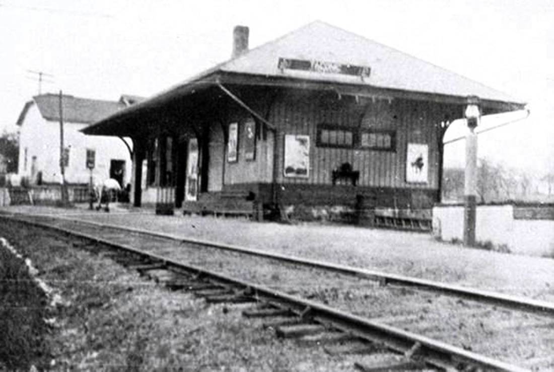
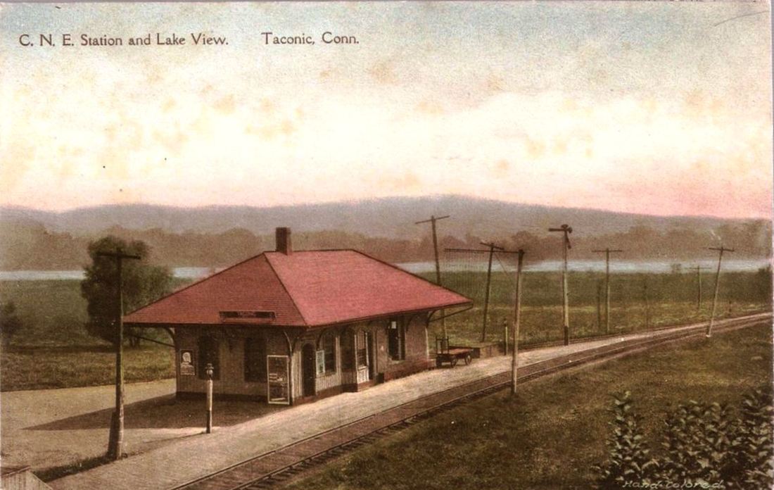
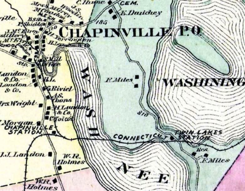
By October, 1872, the Winsted Herald reported that "the depot in Chapinville is being driven ahead" and the Connecticut Western News said "it is well advanced toward completion." The 1880 NY&NE appraisal of CW assets said this station was in good condition and valued it at $1800. It was renamed in 1915 per ICC order eliminating '-ville' names and others potentially confusing for train crews. We have never seen a photo of this depot under its original name. The image at [1] is a val photo (probably from 1916 but left info band cut off) looking west and shows the Borden's creamery building beyond the station. The road bridge is a former turntable inverted for highway use. The stunning, colorized image at [2] is from an unused postcard thought to date to the 1920s and shows Lake Washining, "that beautiful sheet of water" mentioned in the previous entry, in the distance. The image at [3] was taken by Lewis H. Benton, his #2644, taken in 1930 (likely on 6/23 but Nimke says 5/23) and shows the spur at right to the village to serve the expansive and historically innovative facilities of the Landon Co. Iron Works. The Landon name and the works are shown on the snippet from the 1874 Litchfield County Atlas at [4]. The 1938 SSRR list shows this station as retired and to be disposed of; its ultimate fate is not yet known to us. [REFS: HDC/12/21/1871/02; CWN/10/25/1872/02; WH/10/23/1872/03; CW/NYNE1880; N3.92: 1938 photo][rev010518, 120218]
By October, 1872, the Winsted Herald reported that "the depot in Chapinville is being driven ahead" and the Connecticut Western News said "it is well advanced toward completion." The 1880 NY&NE appraisal of CW assets said this station was in good condition and valued it at $1800. It was renamed in 1915 per ICC order eliminating '-ville' names and others potentially confusing for train crews. We have never seen a photo of this depot under its original name. The image at [1] is a val photo (probably from 1916 but left info band cut off) looking west and shows the Borden's creamery building beyond the station. The road bridge is a former turntable inverted for highway use. The stunning, colorized image at [2] is from an unused postcard thought to date to the 1920s and shows Lake Washining, "that beautiful sheet of water" mentioned in the previous entry, in the distance. The image at [3] was taken by Lewis H. Benton, his #2644, taken in 1930 (likely on 6/23 but Nimke says 5/23) and shows the spur at right to the village to serve the expansive and historically innovative facilities of the Landon Co. Iron Works. The Landon name and the works are shown on the snippet from the 1874 Litchfield County Atlas at [4]. The 1938 SSRR list shows this station as retired and to be disposed of; its ultimate fate is not yet known to us. [REFS: HDC/12/21/1871/02; CWN/10/25/1872/02; WH/10/23/1872/03; CW/NYNE1880; N3.92: 1938 photo][rev010518, 120218]
|
|
|

Connecticut Historical Society
|
|
|
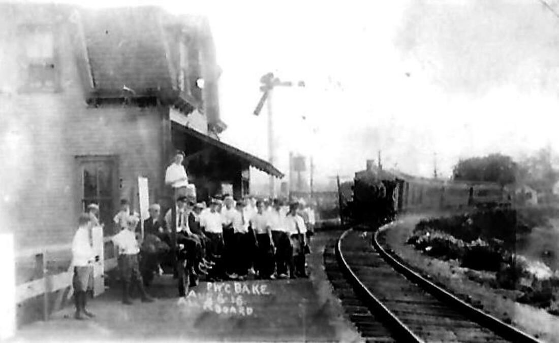
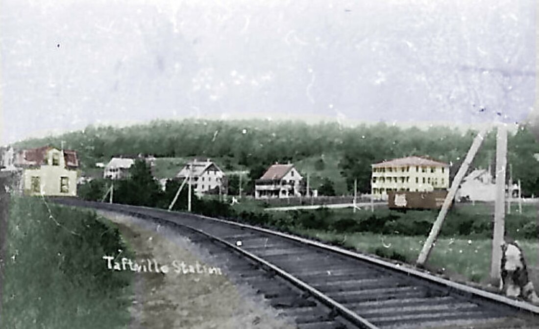
TAFTS/TAFTVILLE [N&W, 1872]
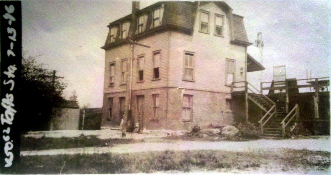
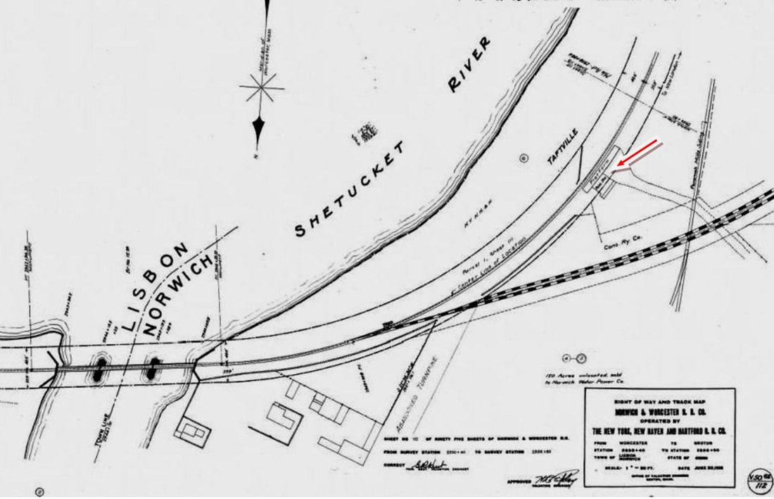
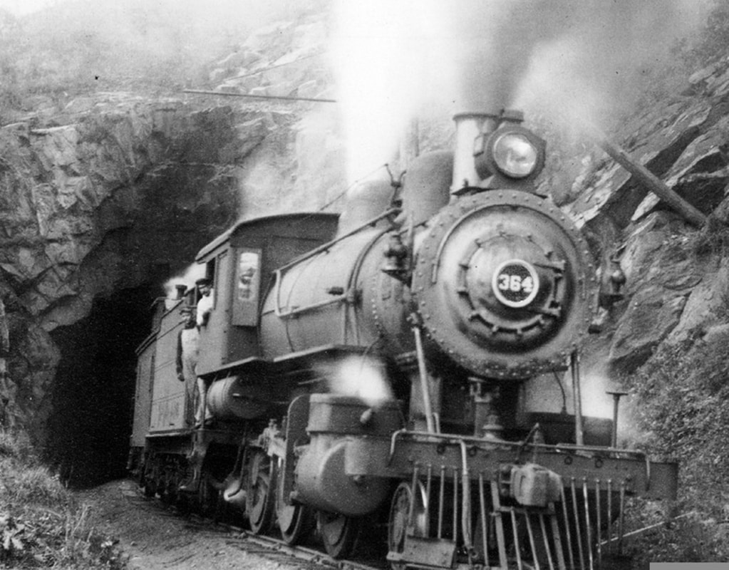
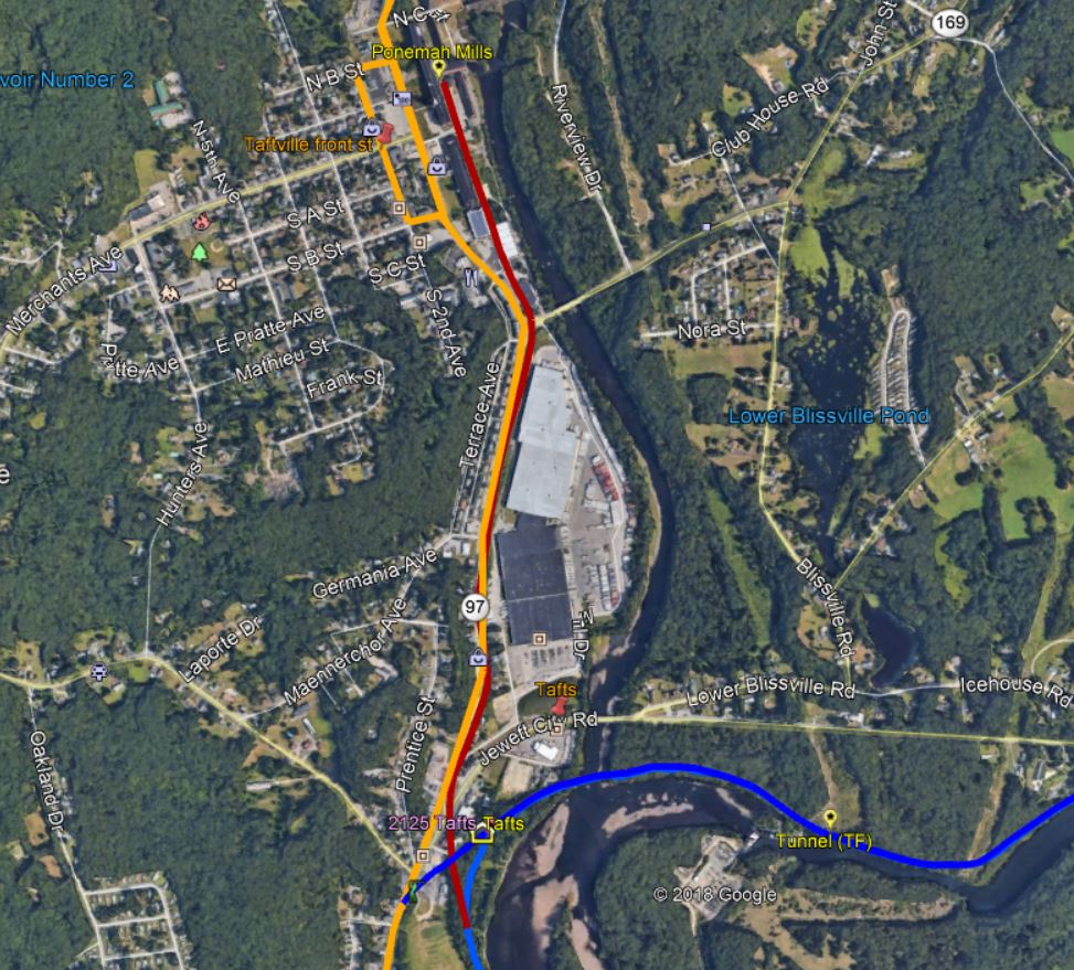
This stop in the northeastern part of Norwich was not an original one on the N&W. There really was no need for a station in this unpopulated area until the great changes that came in 1870 when Orray Taft and associates built the mill to the north and the surrounding factory village known as Taftville sprung up. A brief mention in the Norwich Aurora says in August of 1872 that... "The Norwich and Worcester Railroad company are building a small depot for the Taftville station." The only photos we have show the building above, hardly what we would call a small depot. Elmer Farnham says ... "The depot at Tafts Station went modern in 1916 when it was remodeled, a new furnace installed, and running water piped in. Its lifetime was short, however, for in 1936 it was abandoned and closed down, as passenger traffic by that time had dwindled to a vanishing point." Newspapers confirm much of what he says but they refer to trolley riders enjoying the new amenities, which made us realize for the first time that, even though the interurban lines to both Putnam and Willimantic ran a bit to the rear of the station, trolley passengers must have used this as a station stop. With that being resolved, the other fly in the ointment is the dating of these improvements. The valuation photo at [1] looks east and shows the rear of the TAFTS station looking fully completed, exterior-wise at least, on 7/13/1916, an event that the newspaper dates to August/September. Perhaps the news was running behind the events on the ground. The photo's tint does help to differentiate the brick lower level from the wood-sided upper stories, wording the papers has as "... the new building has been raised two feet and a stone foundation put under the whole building." Other improvements included a 10x18-ft kitchen, a store room, and a waiting room of 12x30 feet, "at one end of which is a quick lunch counter..." City water, toilet and telephone pay station were extras and better outside lighting on the building that was painted a "dull green slate color" was said to be a credit to the locality and "possibly the best waiting room on the whole [Shore Line Electric Rwy] system." The northward view of this station at [2] shows the Ponemah Wheel Club on 8/6/1916 about to embark for a clambake at Rocky Point, an amusement park in Warwick, RI which was a popular getaway for Norwichites. The youthful appearance of the employees betrays the reality of child labor, the subject of an afternoon lecture and a reform issue that was first addressed by federal legislation in the very same year of 1916. The photo at [3] looks south at the station, with a box car spotted on the industrial spur up to the mills. The great panorama at [4] looks southeast and shows a trolley car headed to use the N&W tracks for points north. In the right foreground is the mill track. The red arrow on the 1915 val map at [5] points to the depot; the heavy dashed lines are the Conn. Co. tracks, joining with the N&W at the Shetucket River bridge. The Ponemah Mills track is seen crossing the trolley tracks at the road. At [6] a train emerges from the Taftville tunnel which is about a mile up the N&W. The image at [7] is from our Track 11 Google Earth map, showing the abandoned mill track in red and the trolley lines in orange, shared with blue on the N&W. The trolley line to the left goes to Baltic and Willimantic. According to an early 1936 newspaper article, John Evans, who was contracted to demolish the old N&W roundhouse at the Norwich station, also got the job to raze TAFTS. The depot was reported at that time to have been "considerably wrecked of late, probably by boys who recently got into the building, tore out plumbing and overturned the stove. The Taftville station is a frame building and there is no further use for it as there is no passenger service on the road now." Our timetables show one daily and two Sunday trains stopping here in 1925, but none in 1926. Karr says there were two daily trains running in 1935, perhaps no longer stopping here. The 1938 SSRR only notes the section house here to be disposed of by that time. [REFS: HDC/01/05/1870/04; NAU/04/23/1873/02; RRM 1876-1912; NB/08/07/1916/08; NMB/08/31/1916/09; NMB/09/14/1916/09; NMB/09/30/1916/14; NMB/11/16/1916/12; LETT (5/4/1925); LETT (9/6/1926; NB/03/06/1936/00; K106; Q146,148f; Cummings, Shore Line Electric Railway Company, p100; Farnham, The Quickest Route, p146; NYNH&H Status of Structures to be Retired and Removed, 1938/1939][rev051613, 011019, 051619]
This stop in the northeastern part of Norwich was not an original one on the N&W. There really was no need for a station in this unpopulated area until the great changes that came in 1870 when Orray Taft and associates built the mill to the north and the surrounding factory village known as Taftville sprung up. A brief mention in the Norwich Aurora says in August of 1872 that... "The Norwich and Worcester Railroad company are building a small depot for the Taftville station." The only photos we have show the building above, hardly what we would call a small depot. Elmer Farnham says ... "The depot at Tafts Station went modern in 1916 when it was remodeled, a new furnace installed, and running water piped in. Its lifetime was short, however, for in 1936 it was abandoned and closed down, as passenger traffic by that time had dwindled to a vanishing point." Newspapers confirm much of what he says but they refer to trolley riders enjoying the new amenities, which made us realize for the first time that, even though the interurban lines to both Putnam and Willimantic ran a bit to the rear of the station, trolley passengers must have used this as a station stop. With that being resolved, the other fly in the ointment is the dating of these improvements. The valuation photo at [1] looks east and shows the rear of the TAFTS station looking fully completed, exterior-wise at least, on 7/13/1916, an event that the newspaper dates to August/September. Perhaps the news was running behind the events on the ground. The photo's tint does help to differentiate the brick lower level from the wood-sided upper stories, wording the papers has as "... the new building has been raised two feet and a stone foundation put under the whole building." Other improvements included a 10x18-ft kitchen, a store room, and a waiting room of 12x30 feet, "at one end of which is a quick lunch counter..." City water, toilet and telephone pay station were extras and better outside lighting on the building that was painted a "dull green slate color" was said to be a credit to the locality and "possibly the best waiting room on the whole [Shore Line Electric Rwy] system." The northward view of this station at [2] shows the Ponemah Wheel Club on 8/6/1916 about to embark for a clambake at Rocky Point, an amusement park in Warwick, RI which was a popular getaway for Norwichites. The youthful appearance of the employees betrays the reality of child labor, the subject of an afternoon lecture and a reform issue that was first addressed by federal legislation in the very same year of 1916. The photo at [3] looks south at the station, with a box car spotted on the industrial spur up to the mills. The great panorama at [4] looks southeast and shows a trolley car headed to use the N&W tracks for points north. In the right foreground is the mill track. The red arrow on the 1915 val map at [5] points to the depot; the heavy dashed lines are the Conn. Co. tracks, joining with the N&W at the Shetucket River bridge. The Ponemah Mills track is seen crossing the trolley tracks at the road. At [6] a train emerges from the Taftville tunnel which is about a mile up the N&W. The image at [7] is from our Track 11 Google Earth map, showing the abandoned mill track in red and the trolley lines in orange, shared with blue on the N&W. The trolley line to the left goes to Baltic and Willimantic. According to an early 1936 newspaper article, John Evans, who was contracted to demolish the old N&W roundhouse at the Norwich station, also got the job to raze TAFTS. The depot was reported at that time to have been "considerably wrecked of late, probably by boys who recently got into the building, tore out plumbing and overturned the stove. The Taftville station is a frame building and there is no further use for it as there is no passenger service on the road now." Our timetables show one daily and two Sunday trains stopping here in 1925, but none in 1926. Karr says there were two daily trains running in 1935, perhaps no longer stopping here. The 1938 SSRR only notes the section house here to be disposed of by that time. [REFS: HDC/01/05/1870/04; NAU/04/23/1873/02; RRM 1876-1912; NB/08/07/1916/08; NMB/08/31/1916/09; NMB/09/14/1916/09; NMB/09/30/1916/14; NMB/11/16/1916/12; LETT (5/4/1925); LETT (9/6/1926; NB/03/06/1936/00; K106; Q146,148f; Cummings, Shore Line Electric Railway Company, p100; Farnham, The Quickest Route, p146; NYNH&H Status of Structures to be Retired and Removed, 1938/1939][rev051613, 011019, 051619]
|
Copyright NHRHTA, Inc.
|

UConn Archives & Spec. Colls.
|
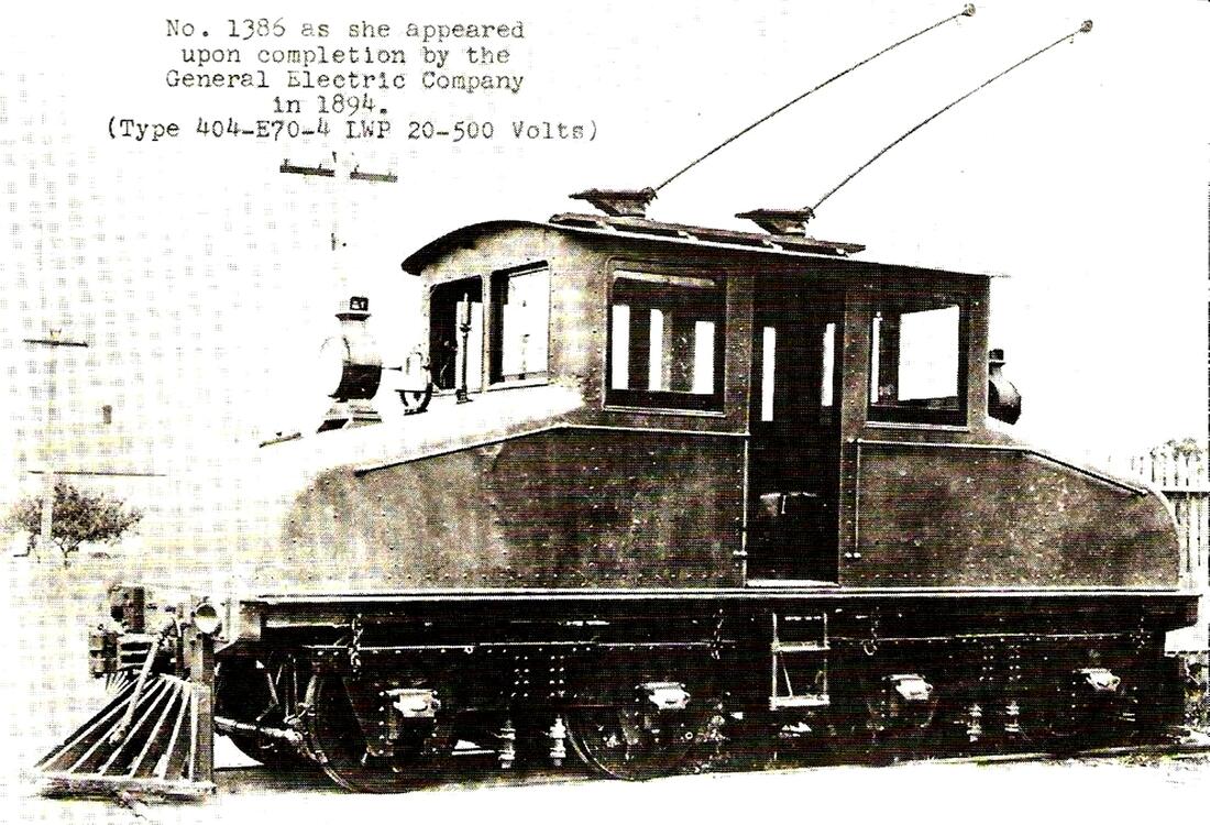
The mill operation and its unique railroad link deserves a paragraph of its own. Taft and associates began building in 1866 what would later be known as Ponemah Mills and would soon be hailed as the largest cloth mill in the country when completed at the end of 1871. By the middle of the previous year work had commenced on rail link with the N&W via a line called the Shetucket Railroad Co., first authorized by the legislature in 1865 and completed in August, 1870 "... from at or near the 'switch' above Greeneville in said town of Norwich to Taftville in said town..." The company also had "... liberty to extend said railway..." to Sprague and a connection with the HP&F. The one-mile link to the mill was all that was ever built and shortly thereafter the paper said "Horses will furnish the motion for the road when completed..." We hear nothing about steam ever being used on this mill line so horses must have sufficed until 1895 when wires were strung on the spur and the electric current that ran the Norwich Street Rwy was made available. The mill then bought G.E. #1386, one of the first electric locomotives produced in this country. The first we hear of it on the property is in the death of Charles L. Brainerd, "a trusted employee... who was run down by an electric freight train used by the company in transporting cotton and finished goods to and from the depot [Tafts]... The motorman in charge of the train operates from the center of the string of cars. All vision of what is directly in front of him is cut off by the foremost cars." The Black Maria, as it became known, ran until 1964 when the mill shut down; the historic engine is now housed at the Connecticut Trolley Museum in East Windsor. In the lower set of photos, the 1875 Tilden state map at [1] is the earliest we could find showing the 1870 mill line running up to Taftville. The G.E. builder's photo dated 1894 is at [2] and the image at [3] shows the locomotive just north of TAFTS station, probably in the 1950s. The shot at [4] is the same location as [3] today with a piece of the mill railroad track apparently still in the ground. When the trains, trolleys and the mill railroad were all running, this must have been quite the spot for railfans! [REFS: Conn. Private Laws 5.725 (7/7/1865), Conn. Special Acts 6.804 (6/9/1870); NAU/07/27/1870/03; HDC/08/16/1870/04; NAU//12/20/1871/04; NHJC/01/05/1881/03; NMB/05/21/1913/08; NB/04 /21/1915/13; SL18.3.37 (1987); New London County Trolleys, p72][rev011019]
Max Miller Collection
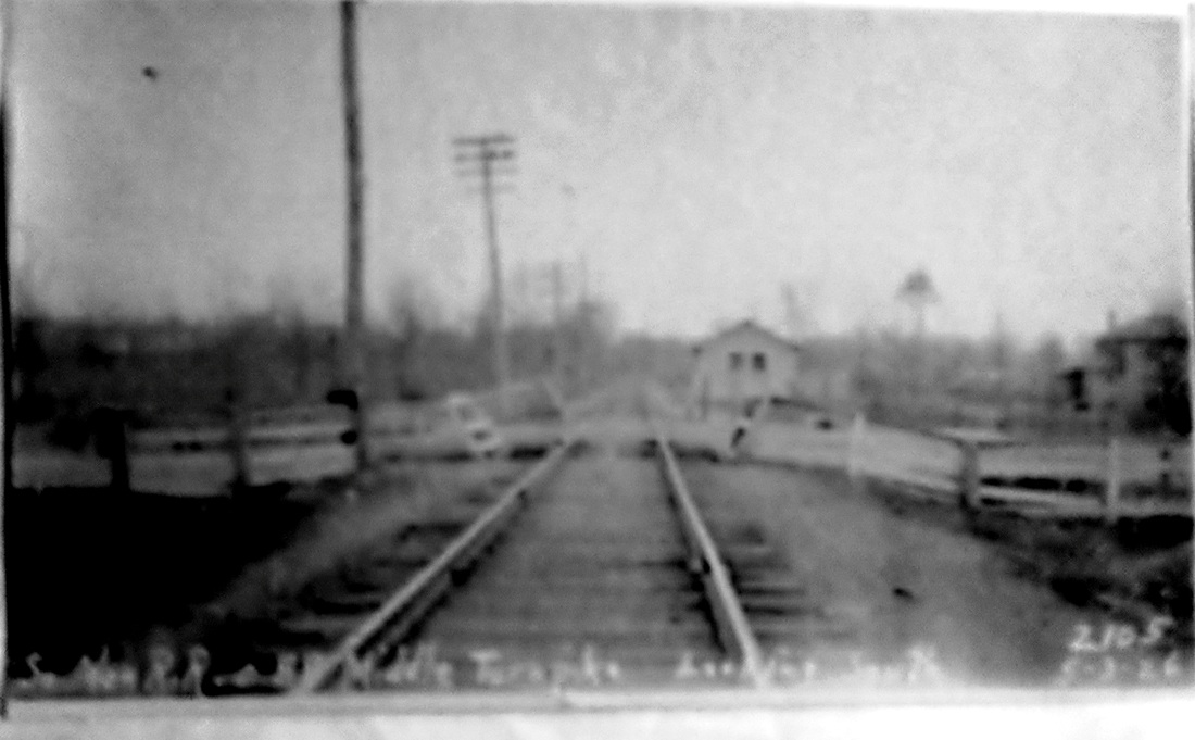
TAINTORS CROSSING [NYNH&H, c1900?]
We do not see the small station here that was supposed to be at this crossing at Middle Turnpike in the town of MANCHESTER. We have additional photos to scrutinize. [REFS: SAS27]
We do not see the small station here that was supposed to be at this crossing at Middle Turnpike in the town of MANCHESTER. We have additional photos to scrutinize. [REFS: SAS27]
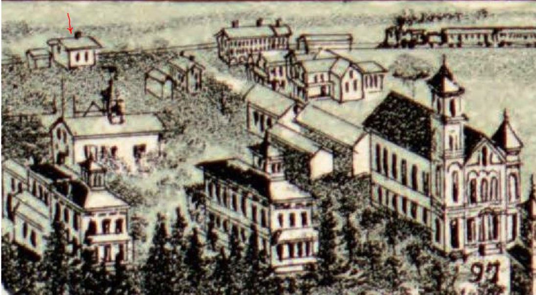
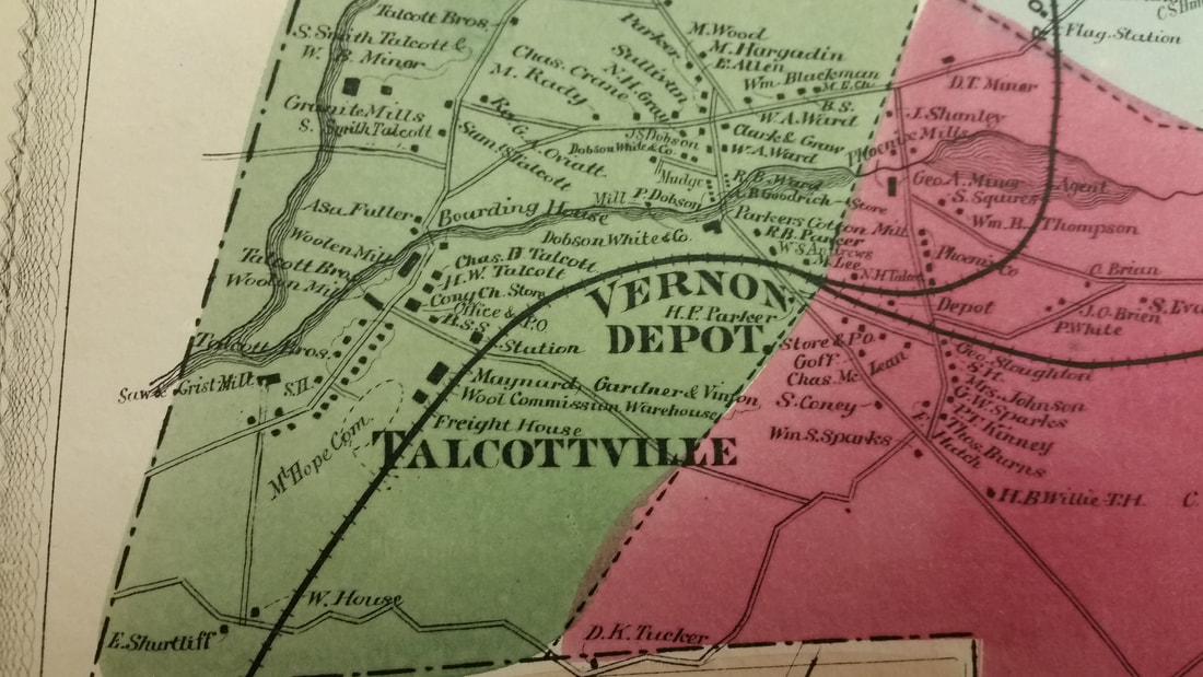
TALCOTTVILLE1 [HP&F, 1849]
This line opened through the town of Vernon in 1849 but timetables we have seen show no station prior to 1872. The first mention of a structure here is in the Courant in 1867 where it is described as "a small depot station, with a board having the word Talcottville written upon it." In 1869, an article says that a commission wool house to be erected by the track nearby and the "little depot" was to be enlarged and a side track added. This may be the expanded station from 1869 that is mentioned in the article above. The image is from the 1895 Bailey bird's-eye map of Vernon and our red arrow points to the station. Between 1907 and 1924, there was electric car service from Burnside Jct. in East Hartford to Rockville along the old NY&NE. [REFS: HDC/03/15/1867/01; HDC/02/22/1869/04; HC/12/16/1907/10; HC/01/13/1908/01]
This line opened through the town of Vernon in 1849 but timetables we have seen show no station prior to 1872. The first mention of a structure here is in the Courant in 1867 where it is described as "a small depot station, with a board having the word Talcottville written upon it." In 1869, an article says that a commission wool house to be erected by the track nearby and the "little depot" was to be enlarged and a side track added. This may be the expanded station from 1869 that is mentioned in the article above. The image is from the 1895 Bailey bird's-eye map of Vernon and our red arrow points to the station. Between 1907 and 1924, there was electric car service from Burnside Jct. in East Hartford to Rockville along the old NY&NE. [REFS: HDC/03/15/1867/01; HDC/02/22/1869/04; HC/12/16/1907/10; HC/01/13/1908/01]
|
|
|
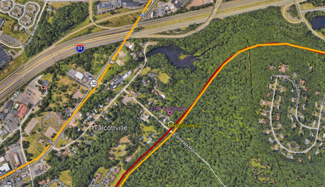
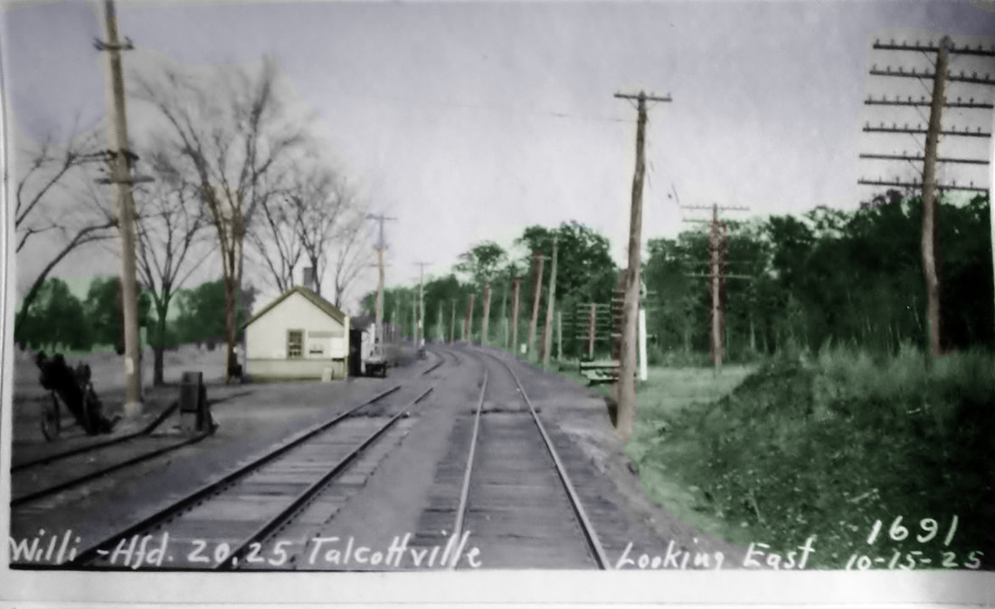
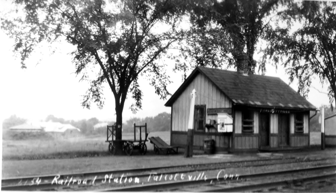
TALCOTTVILLE2 [NYNH&H, c1910?]
The eastward-looking PUC photo at [1] was taken on 10/15/1925. The shot at [2] is Lewis H. Benton #2154, the number placing the date as the summer of 1928. The 1869 map at [3] shows the stop at that time. The snippet at [4] gives the location today on Elm Hill Rd. The 1938 SSRR list shows this station to have been sold on 2/28/1939 for $5.00 to L. Francis. [rev010518]
The eastward-looking PUC photo at [1] was taken on 10/15/1925. The shot at [2] is Lewis H. Benton #2154, the number placing the date as the summer of 1928. The 1869 map at [3] shows the stop at that time. The snippet at [4] gives the location today on Elm Hill Rd. The 1938 SSRR list shows this station to have been sold on 2/28/1939 for $5.00 to L. Francis. [rev010518]
|
|
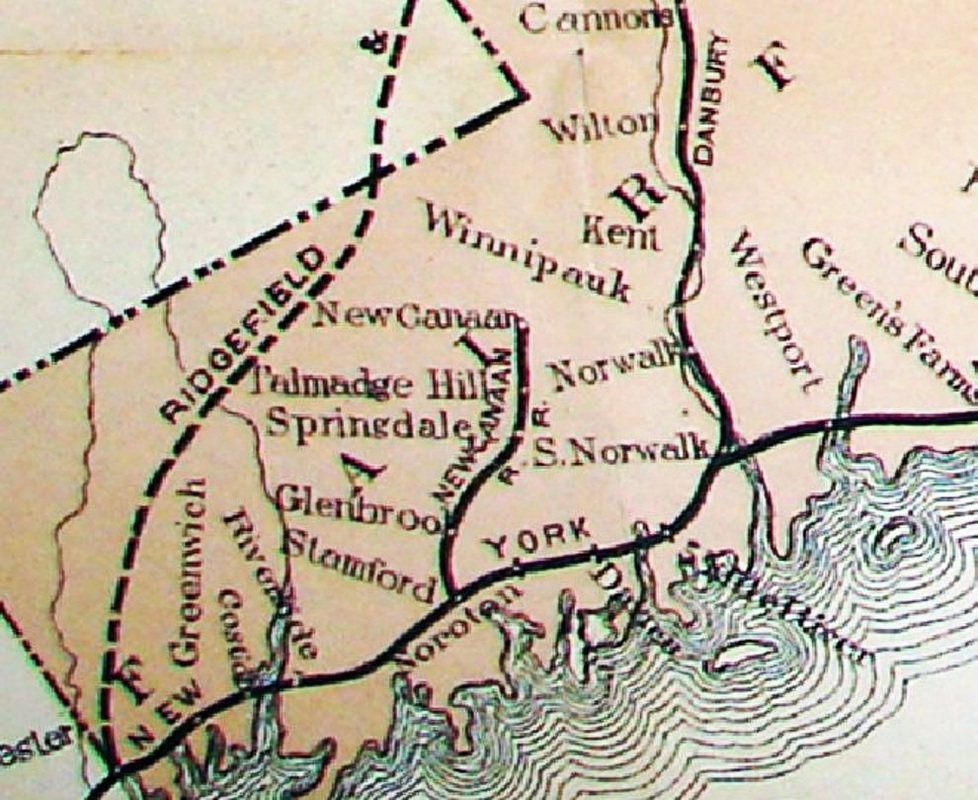
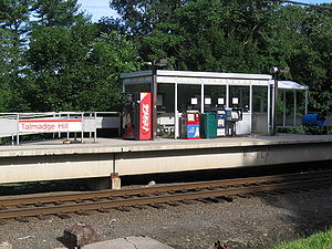
TALMADGE HILL1 [NC, 1868]
This flag stop in the town of NEW CANAAN goes back to the opening of the NCRR in 1868. Reportedly this was going to be named Smiths Station for the numerous families so-surnamed in this area; there was a Smiths Ridge post office here from 1851 to 1883. When William Talmadge provided land for the NCRR, the naming went to him instead. The 1867 map shows the station location at the red arrow and Talmadge's home at the blue arrow. The 3/7/1886 timetable at [2] shows the stop shortly after the 1883 takeover by the NYNH&H. It is also seen on the railroad commissioners map of 1877 at [3]. What station structure, if any, originally stood here is not yet known. There is a mention of "Talmadge Hill station" in an 1876 newspaper article but it does not specifically say there was a depot here. An 1881 ad says, however, that a farm for sale is "within three minutes' walk from depot, five miles from Stamford." Another curious report is of a man struck by a train and having to be dug out from under the pilot of the locomotive in 1884 while walking along the track from SPRINGDALE to his home on Talmadge Hill. Why he would not have disembarked at this station is a question that begs an answer. [REFS: SA/07/14/1876/02; SA/04/21/1881/02; NHER/10/30/1884/04][rev122514]
This flag stop in the town of NEW CANAAN goes back to the opening of the NCRR in 1868. Reportedly this was going to be named Smiths Station for the numerous families so-surnamed in this area; there was a Smiths Ridge post office here from 1851 to 1883. When William Talmadge provided land for the NCRR, the naming went to him instead. The 1867 map shows the station location at the red arrow and Talmadge's home at the blue arrow. The 3/7/1886 timetable at [2] shows the stop shortly after the 1883 takeover by the NYNH&H. It is also seen on the railroad commissioners map of 1877 at [3]. What station structure, if any, originally stood here is not yet known. There is a mention of "Talmadge Hill station" in an 1876 newspaper article but it does not specifically say there was a depot here. An 1881 ad says, however, that a farm for sale is "within three minutes' walk from depot, five miles from Stamford." Another curious report is of a man struck by a train and having to be dug out from under the pilot of the locomotive in 1884 while walking along the track from SPRINGDALE to his home on Talmadge Hill. Why he would not have disembarked at this station is a question that begs an answer. [REFS: SA/07/14/1876/02; SA/04/21/1881/02; NHER/10/30/1884/04][rev122514]
|

|
|

Max Miller Collection
|

|
|

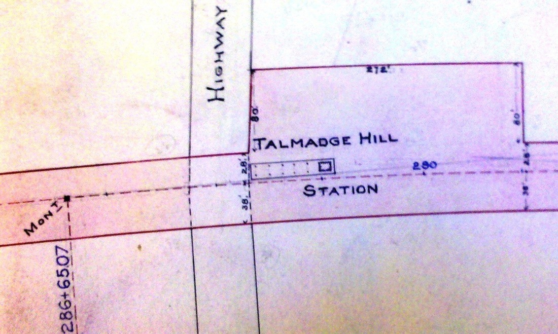
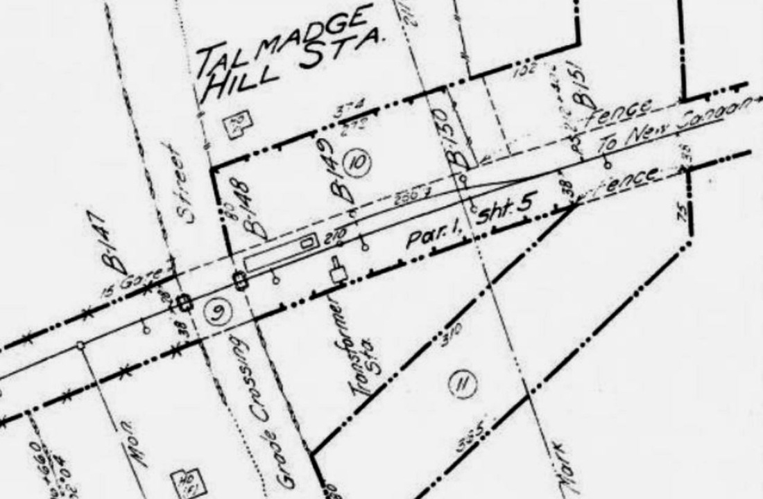
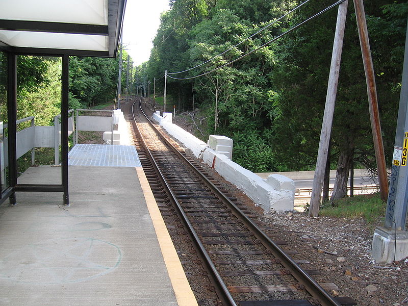
TALMADGE HILL2 [NYNH&H, 1889]
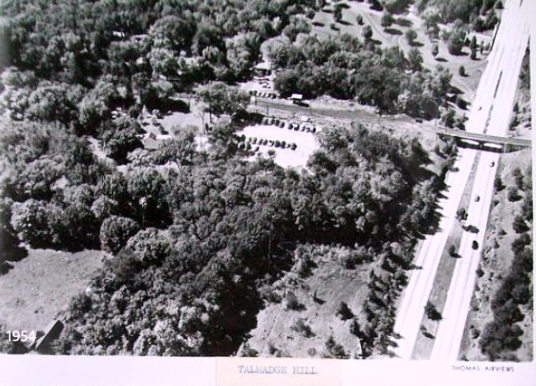
The railroad commissioners said in their 1889 annual report that a shelter had been built here. The 1889 map at [1] shows the posts for the covershed. The saltbox style was common along the New York Division and elsewhere in the late 1890s but this one is so much shorter that it has a tower-like look to it. The undated view at [2] looks east. The 1915 val map at [3] shows this station on the west side of the track with a 250-ft freight siding coming from the north. The PUC image at [4] was taken on 5/17/1927 and looks north with the mileage point listed as 5.7 miles from Stamford. The views at [5] and [7] are perhaps ca. 1950 and show the passenger canopy gone, a retrenchment in days of dwindling revenues after World War II. The Thomas Airview at [6] is from 1954 and appears to have been one of a set commissioned by the NYNH&H, of which we have seen others. Just above the depot, a beautiful 1937 George Dunkelberger bridge carries the line over the Merritt Parkway which opened from Greenwich to Norwalk on June 29, 1938 [click here]. Permission to close this station along with many others was denied by the PUC in 1963. The structure likely came down when the high-level platforms were built in 1974. [REFS: HDC/08/27/1869/04; CRC37.1889.17; SA/10/17/1901/02; HC/05/30/1963/07; HC/05/23/1974/95D][rev030215]
The railroad commissioners said in their 1889 annual report that a shelter had been built here. The 1889 map at [1] shows the posts for the covershed. The saltbox style was common along the New York Division and elsewhere in the late 1890s but this one is so much shorter that it has a tower-like look to it. The undated view at [2] looks east. The 1915 val map at [3] shows this station on the west side of the track with a 250-ft freight siding coming from the north. The PUC image at [4] was taken on 5/17/1927 and looks north with the mileage point listed as 5.7 miles from Stamford. The views at [5] and [7] are perhaps ca. 1950 and show the passenger canopy gone, a retrenchment in days of dwindling revenues after World War II. The Thomas Airview at [6] is from 1954 and appears to have been one of a set commissioned by the NYNH&H, of which we have seen others. Just above the depot, a beautiful 1937 George Dunkelberger bridge carries the line over the Merritt Parkway which opened from Greenwich to Norwalk on June 29, 1938 [click here]. Permission to close this station along with many others was denied by the PUC in 1963. The structure likely came down when the high-level platforms were built in 1974. [REFS: HDC/08/27/1869/04; CRC37.1889.17; SA/10/17/1901/02; HC/05/30/1963/07; HC/05/23/1974/95D][rev030215]
Wikipedia
|
Wikipedia
|
Wikipedia
|
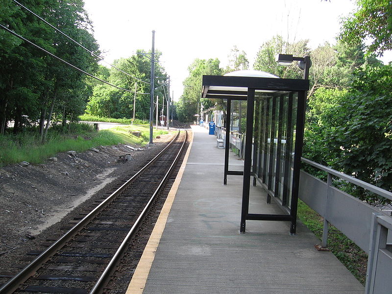
TALMADGE HILL3 [MN, 1972?]
The current station actually consists of three structures, a square central enclosure and two auxiliary kiosks. The proximity to the Merritt Parkway overpass is seen in the shot at right that, of course, looks north. The complex is located just west of Hoyt St., Rte. 106, at the intersection of Talmadge Hill Rd.
The current station actually consists of three structures, a square central enclosure and two auxiliary kiosks. The proximity to the Merritt Parkway overpass is seen in the shot at right that, of course, looks north. The complex is located just west of Hoyt St., Rte. 106, at the intersection of Talmadge Hill Rd.
|
|

|
|
Tariffville Village Association
|
Tariffville Village Association
|
|

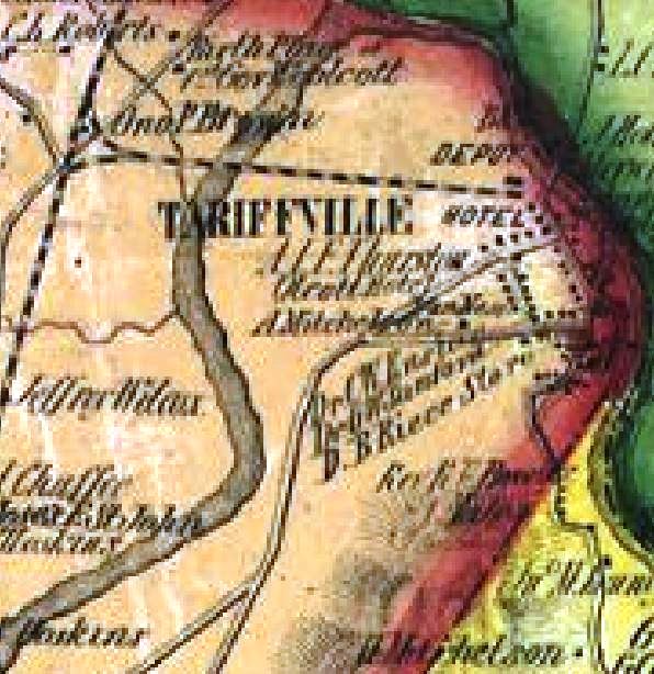
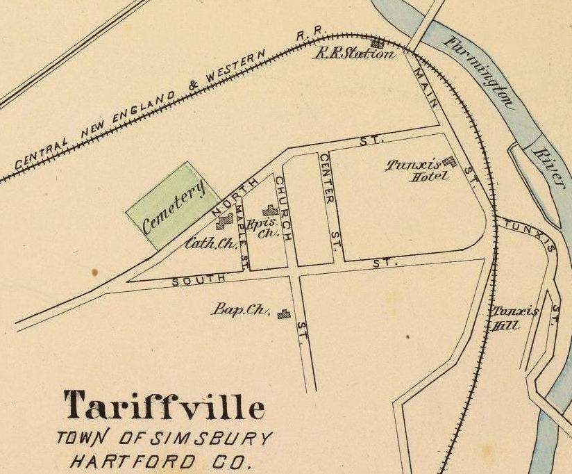
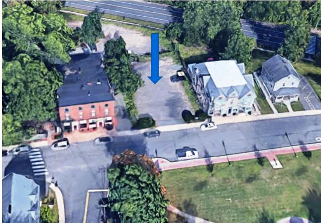
TARIFFVILLE1 [NH&N, 1850]
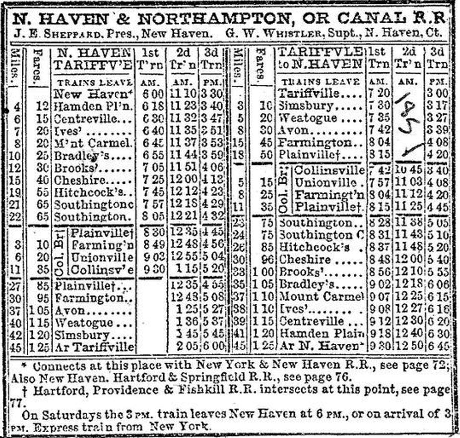
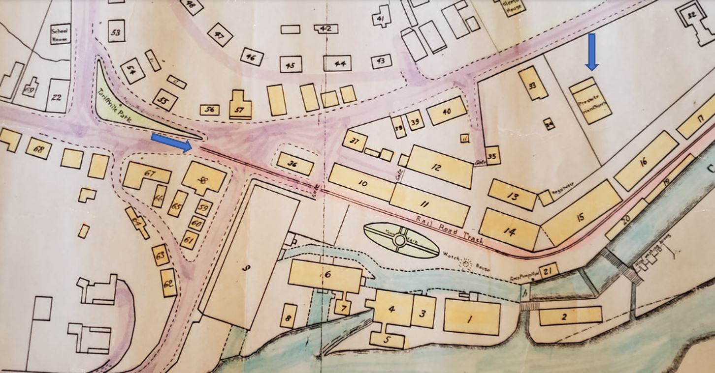
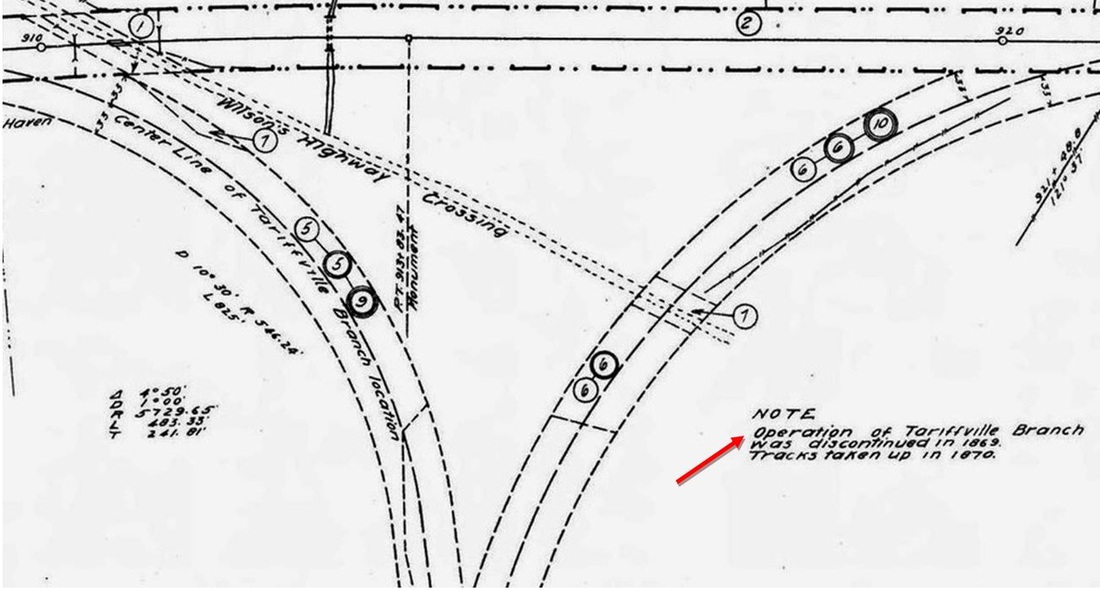
This tiny village in the town of Simsbury belies a disproportionately large state railroad history. We have no photo of TARIFFVILLE1 but map footprints show that it may have looked like other Canal line stations of the era, the image at [1] being the still extant depot at Simsbury. The NH&H had just completed its expansion from PLAINVILLE in 1850 that brought it to COLLINSVILLE, GRANBY and TARIFFVILLE, this last location chosen as terminus for access to what was originally the Tariff Manufactuing Co., fostered in 1825 in the wake of higher tariffs on wool that spurred carpet making in this country to compete with Europe. To access what was later the Hartford Carpet Co. the NH&N built across the Farmington River floodplain from a wye at HOSKINS [JUNCTION], seen on the 1855 HC map snippet at [2]. The branch was completed on 1/16/1850 and a newspaper article of 2/23/1850 reported that there was to be "one of the grand Balls at Tariffville on the night of the 1st of March, on which occasion the new and spacious Railroad Depot will be opened at that place." Mention is made of "one hundred managers" indicating the economic vitality of the moment which the railroad had come to serve. Payroll sheets from the next year show a station agent, a helper, two engineers and two brakeman employed on the line. The shot at [3] shows the eroded pilings for the Canal line bridge across the Farmington River. The 1851 timetable at [4] has TARIFFVILLE as the terminus it would remain for the next 20 years. The railroad property, with passenger station, freight and engine houses, is seen on the 1850 map at [5]. The upper-end-of-Main St. location for the facilities was logical for needed space and access to additional traffic coming from Granby, today East Granby, across the bridge there. Continuing to the left on the 1850 map, the snippet at [6] shows the long spur that cut off west of the station and curved down to the mill complex at village center. The blue arrow at left on the map shows the track ending at the multi-story mill building. With ups and downs, the carpet company lasted until a devastating fire on 6/10/1867 ruined the mill and decimated the village. Not surprisingly, the Canal line ended service two years later and left its depot vacant. Thus the 1916 valuation map at [7] reads: "Operation of the Tariffville Branch was discontinued in 1869. Tracks taken up in 1870." But help was soon on the way and business revived with the coming of the Connecticut Western RR the next year. Many challenges faced the new railroad in threading its way through the narrow town center, highlands on the west and the river on the east. One obstacle was the old Presbyterian, now Episcopal, church which sat directly on the planned ROW; see the right blue arrow on the map at [6]. The only solution: Execute a legal condemnation and pay the parish for the property. Then the dismantling. What seems to have happened initially is that the north and south walls were taken down but the other two walls and even possibly the roof were left intact when the trains started running through what may have been a tunnel. The newspapers typically had reporters ride trains when new lines opened. The one writing for the Winsted Herald, in extolling the scenery along the CW route, described this situation almost as part of the natural terrain, saying glibly that "... At Tariffville the railway makes a huge hole directly through the Episcopal church, a large brick building that still stands over (our italics) the track, and unless removed will soon afford an inside view to thousands who don't yet know what the inside of a church is made of." Jocular commentary on church attendance? Presumably, the rest of the structure was taken down soon afterward but the block remained identifiable on railroad property maps a century later. The next challenge was where to put the track at the narrow, upper end of Main St. The only answer was right next to the Canal line's abandoned branch. And finally, where to put the CW depot? Dismissing the suggestion that the demolished church site would be the most convenient for the village, the CW took the easy way out and rented the old Canal line station which it used for the next 20 years until it burned in 1892. Forty years old by that time and orphaned between an uncaring lessor and an impoverished lessee, it had become an eyesore and no opportunity to revile it was lost. More on this in the next entry! The Canal line, of course, still retained possession of the ROW and the station grounds and leased them in 1887 to the NYNH&H which made good use of the obstacle in efforts to block the CNE's Springfield Extension in 1899. The snippet at [7] is from our Track 11 Google Earth map. Color codings here indicate the 1850 Canal line trackage in green, the 1871 CW trackage in red and the 1900 CNE trackage in yellow. Note also that, in spite of many claims that the CW bought the Canal line branch to Hoskins as part of its ROW, the assertion is completely and unequivocally false. The green and red lines on our map show conclusively that the two ROWs were widely separate. A corollary untruth is that the bridge collapse of 1878 was on the Canal line branch; again it was not. It occurred on the CW line where the pin on our map indicates. [REFS: NHNAR4.1850.5; SR/01/03/1850/02; HTI/01/19/1850/03; HTI/02/23/1850/03; 1858GED; Ash, 1864, p41; SU/09/30/1864/02; WH/12/15/1871/02; HDC/12/21/1871/02; HDC/08/28/1872/02 [rev071315, 041019, 112419, 041020]
This tiny village in the town of Simsbury belies a disproportionately large state railroad history. We have no photo of TARIFFVILLE1 but map footprints show that it may have looked like other Canal line stations of the era, the image at [1] being the still extant depot at Simsbury. The NH&H had just completed its expansion from PLAINVILLE in 1850 that brought it to COLLINSVILLE, GRANBY and TARIFFVILLE, this last location chosen as terminus for access to what was originally the Tariff Manufactuing Co., fostered in 1825 in the wake of higher tariffs on wool that spurred carpet making in this country to compete with Europe. To access what was later the Hartford Carpet Co. the NH&N built across the Farmington River floodplain from a wye at HOSKINS [JUNCTION], seen on the 1855 HC map snippet at [2]. The branch was completed on 1/16/1850 and a newspaper article of 2/23/1850 reported that there was to be "one of the grand Balls at Tariffville on the night of the 1st of March, on which occasion the new and spacious Railroad Depot will be opened at that place." Mention is made of "one hundred managers" indicating the economic vitality of the moment which the railroad had come to serve. Payroll sheets from the next year show a station agent, a helper, two engineers and two brakeman employed on the line. The shot at [3] shows the eroded pilings for the Canal line bridge across the Farmington River. The 1851 timetable at [4] has TARIFFVILLE as the terminus it would remain for the next 20 years. The railroad property, with passenger station, freight and engine houses, is seen on the 1850 map at [5]. The upper-end-of-Main St. location for the facilities was logical for needed space and access to additional traffic coming from Granby, today East Granby, across the bridge there. Continuing to the left on the 1850 map, the snippet at [6] shows the long spur that cut off west of the station and curved down to the mill complex at village center. The blue arrow at left on the map shows the track ending at the multi-story mill building. With ups and downs, the carpet company lasted until a devastating fire on 6/10/1867 ruined the mill and decimated the village. Not surprisingly, the Canal line ended service two years later and left its depot vacant. Thus the 1916 valuation map at [7] reads: "Operation of the Tariffville Branch was discontinued in 1869. Tracks taken up in 1870." But help was soon on the way and business revived with the coming of the Connecticut Western RR the next year. Many challenges faced the new railroad in threading its way through the narrow town center, highlands on the west and the river on the east. One obstacle was the old Presbyterian, now Episcopal, church which sat directly on the planned ROW; see the right blue arrow on the map at [6]. The only solution: Execute a legal condemnation and pay the parish for the property. Then the dismantling. What seems to have happened initially is that the north and south walls were taken down but the other two walls and even possibly the roof were left intact when the trains started running through what may have been a tunnel. The newspapers typically had reporters ride trains when new lines opened. The one writing for the Winsted Herald, in extolling the scenery along the CW route, described this situation almost as part of the natural terrain, saying glibly that "... At Tariffville the railway makes a huge hole directly through the Episcopal church, a large brick building that still stands over (our italics) the track, and unless removed will soon afford an inside view to thousands who don't yet know what the inside of a church is made of." Jocular commentary on church attendance? Presumably, the rest of the structure was taken down soon afterward but the block remained identifiable on railroad property maps a century later. The next challenge was where to put the track at the narrow, upper end of Main St. The only answer was right next to the Canal line's abandoned branch. And finally, where to put the CW depot? Dismissing the suggestion that the demolished church site would be the most convenient for the village, the CW took the easy way out and rented the old Canal line station which it used for the next 20 years until it burned in 1892. Forty years old by that time and orphaned between an uncaring lessor and an impoverished lessee, it had become an eyesore and no opportunity to revile it was lost. More on this in the next entry! The Canal line, of course, still retained possession of the ROW and the station grounds and leased them in 1887 to the NYNH&H which made good use of the obstacle in efforts to block the CNE's Springfield Extension in 1899. The snippet at [7] is from our Track 11 Google Earth map. Color codings here indicate the 1850 Canal line trackage in green, the 1871 CW trackage in red and the 1900 CNE trackage in yellow. Note also that, in spite of many claims that the CW bought the Canal line branch to Hoskins as part of its ROW, the assertion is completely and unequivocally false. The green and red lines on our map show conclusively that the two ROWs were widely separate. A corollary untruth is that the bridge collapse of 1878 was on the Canal line branch; again it was not. It occurred on the CW line where the pin on our map indicates. [REFS: NHNAR4.1850.5; SR/01/03/1850/02; HTI/01/19/1850/03; HTI/02/23/1850/03; 1858GED; Ash, 1864, p41; SU/09/30/1864/02; WH/12/15/1871/02; HDC/12/21/1871/02; HDC/08/28/1872/02 [rev071315, 041019, 112419, 041020]
|
|
|
TARIFFVILLE2 [CNE&W, 1892]
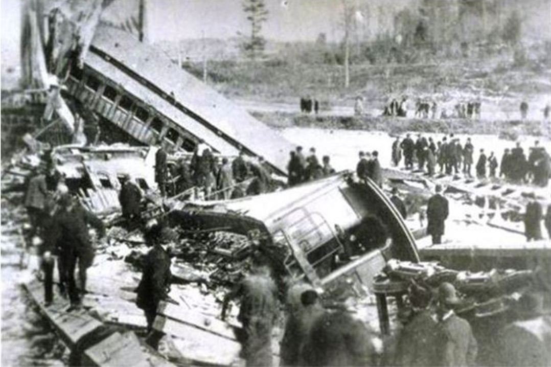
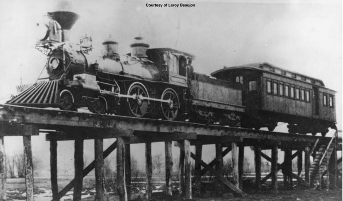
In explaining the transition to the next station, it was the Connecticut Western News that gave us the valuable insight, hitherto unknown, that the CW had used the Canal line depot. It reported thusly: "The old building used as a railroad depot at Tariffville was destroyed by an incendiary fire on Wednesday evening of last week [5/4/1892]. It belonged to the Consolidated road [the NYNH&H had leased the Canal line in 1887] and was erected when that company's branch track extended across the meadows. The C.N.E. & W. road have used it for 20 years but will now build a depot on the opposite side of the track and nearer the centre of the village. The loss will hardly exceed $200." Three tramps were in the building when TARIFFVILLE1 burned; they could only be charged with trespassing because there was no evidence that they set the fire. Most everything of value was rescued "... except a few paint pots, brushes and ladders belonging to the Ladies Village Improvement Society which was about to whitewash, paint, and paper the old structure which had long been an eyesore to the people of the community...." because they were tired of waiting for the railroad to do it. The Winsted Citizen wrote the following poignant requiem: "The Tariffville railroad station burned the other night. It was the meanest, shabbiest, dirtiest and most disgraceful hog pen on the road between Hartford and Poughkeepsie through courtesy known as an alleged railroad station..." Communities frequently criticized their depots for unsavory conditions but this one takes the cake! Newspaper articles indicate that work was undertaken immediately to replace the station that had burned. Within a week, a crew was busy and seven days later the paper said "the new railroad station of the Central New England and Western road, being built across the track from the site of the old structure that burned, is nearly finished. It will be small, but a decided improvement over the old building." One week later, the report was that "the new railroad station, although not finished, is far enough advanced to be used by the station master." Later referred to as "a shanty depot," no photos have yet been found for TARIFFVILLE2 which stood south of the track, as seen on the 1893 map at [1] opposite to where the prior one stood. Once again calls had been ignored for building the new station at the Episcopal Church site, the plot shown by the blue arrow at [3] between Marco's and the Cracker Barrel eateries on Main St. The new depot was nevertheless heralded as being closer to town, microscopically so, it would appear. TARIFFVILLE2 would serve until 1903 even after the wye for the Springfield Branch had been installed a short distance down Main St. Extended; suitable signaling must have been in place to protect the tri-directional traffic at the junction. We don't know what happened to this structure after it was replaced. The unique prior history of the railroad coming to this village was later subordinated to the tragic bridge collapse of 1/15/1878 seen at [2], rescue engine #9, Simsbury, at 3] and the later "The Battle for Springfield." Both these events would give this village a place in the state railroad history out of all proportion to its size or importance otherwise. [REFS: WH/07/29/1881/02; SR/11/12/1883/06; HDC/09/20/1886/04; Poor, 1889, p55; HC/04/12/1892/00; HC/05/06/1892/06; WC/05/06/1892/00; CWN/05/12/1892/02; WH/05/20/1892/02; HC/05/21/1892/06; WH/05/27/1892/02; HC/06/06/1894/08; WH/06/24/1892/02; HC/10/11/1898/03; NHER/01/31/1899/01][rev011715, 112319, 041020]
In explaining the transition to the next station, it was the Connecticut Western News that gave us the valuable insight, hitherto unknown, that the CW had used the Canal line depot. It reported thusly: "The old building used as a railroad depot at Tariffville was destroyed by an incendiary fire on Wednesday evening of last week [5/4/1892]. It belonged to the Consolidated road [the NYNH&H had leased the Canal line in 1887] and was erected when that company's branch track extended across the meadows. The C.N.E. & W. road have used it for 20 years but will now build a depot on the opposite side of the track and nearer the centre of the village. The loss will hardly exceed $200." Three tramps were in the building when TARIFFVILLE1 burned; they could only be charged with trespassing because there was no evidence that they set the fire. Most everything of value was rescued "... except a few paint pots, brushes and ladders belonging to the Ladies Village Improvement Society which was about to whitewash, paint, and paper the old structure which had long been an eyesore to the people of the community...." because they were tired of waiting for the railroad to do it. The Winsted Citizen wrote the following poignant requiem: "The Tariffville railroad station burned the other night. It was the meanest, shabbiest, dirtiest and most disgraceful hog pen on the road between Hartford and Poughkeepsie through courtesy known as an alleged railroad station..." Communities frequently criticized their depots for unsavory conditions but this one takes the cake! Newspaper articles indicate that work was undertaken immediately to replace the station that had burned. Within a week, a crew was busy and seven days later the paper said "the new railroad station of the Central New England and Western road, being built across the track from the site of the old structure that burned, is nearly finished. It will be small, but a decided improvement over the old building." One week later, the report was that "the new railroad station, although not finished, is far enough advanced to be used by the station master." Later referred to as "a shanty depot," no photos have yet been found for TARIFFVILLE2 which stood south of the track, as seen on the 1893 map at [1] opposite to where the prior one stood. Once again calls had been ignored for building the new station at the Episcopal Church site, the plot shown by the blue arrow at [3] between Marco's and the Cracker Barrel eateries on Main St. The new depot was nevertheless heralded as being closer to town, microscopically so, it would appear. TARIFFVILLE2 would serve until 1903 even after the wye for the Springfield Branch had been installed a short distance down Main St. Extended; suitable signaling must have been in place to protect the tri-directional traffic at the junction. We don't know what happened to this structure after it was replaced. The unique prior history of the railroad coming to this village was later subordinated to the tragic bridge collapse of 1/15/1878 seen at [2], rescue engine #9, Simsbury, at 3] and the later "The Battle for Springfield." Both these events would give this village a place in the state railroad history out of all proportion to its size or importance otherwise. [REFS: WH/07/29/1881/02; SR/11/12/1883/06; HDC/09/20/1886/04; Poor, 1889, p55; HC/04/12/1892/00; HC/05/06/1892/06; WC/05/06/1892/00; CWN/05/12/1892/02; WH/05/20/1892/02; HC/05/21/1892/06; WH/05/27/1892/02; HC/06/06/1894/08; WH/06/24/1892/02; HC/10/11/1898/03; NHER/01/31/1899/01][rev011715, 112319, 041020]

|
|
|

|
|

|
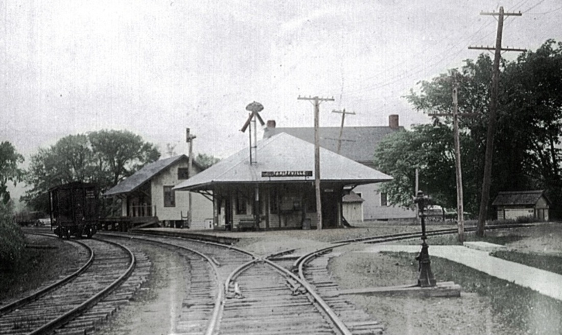
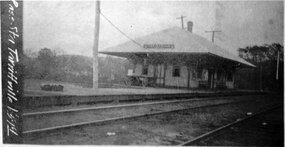
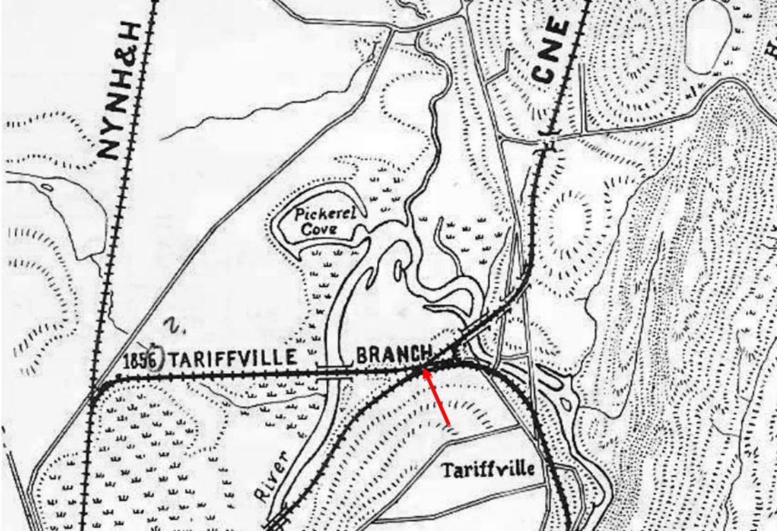
TARIFFVILLE3 [CNE, 1903]
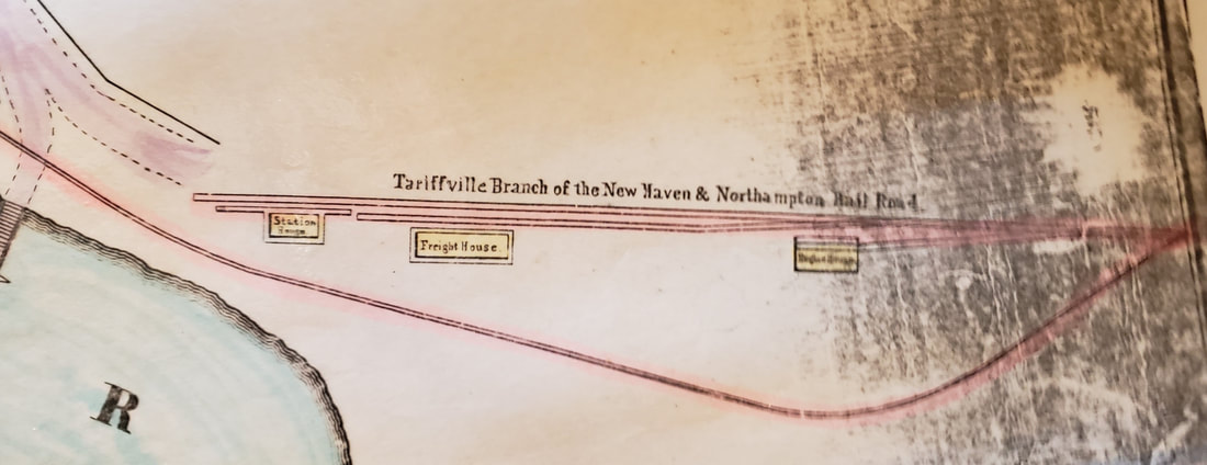
The Connecticut Western News reported in April, 1903 that "the Central New England railway is building a new passenger station at Tariffville between the tracks of the main line and those of the Springfield branch." The wording well explains the diagonally positioned agent's bay in the southeast corner, built to let the occupant see in three directions. This triangularity also necessitated the rounded platform to accommodate the sharply curved eastern leg of the wye that was completed back in March, 1900. Other newspaper reports verify the building of the freight depot in the distance, also in 1903, for the traffic that was "steadily increasing over the branch line." Nimke's claim of 1905 for both of these structures is apparently in error. The photo at [1] is probably the earliest, possibly when the station was new in 1903 and has Tariffville misspelled with two Rs. The others at [2] and [3] show changes in the doors, windows, signboard, and train order signal; the latter view is an undated valuation photo probably ca. 1917. The changes culminate in the 7/12/1929 PUC photo at [4]. The focus of the first engagement in "The Battle for Springfield" shows on Bob Adams's map [5] at our red arrow where the CNE fought and won the right in 1899 to cross the abandoned 1850 (not 1856) NH&N spur at grade. The NYNH&H had wanted a bridge over the defunct ROW! Construction proceeded northward from this point and southward from what would become known as Agawam Jct. where the CNE would use B&A tracks into Springfield. Round Two came in June, 1899 when the NYNH&H surreptitiously obtained the Montague Farm property in East Granby and deliberately obstructed the completion of the line, forcing the CNE to charter and build the East Granby and Suffield RR, a 3.5-mile, $60,000 loop around the farm: see EAST GRANBY for more. The depths to which the shennanigans fell reached near comedic proportions with one crew laying track in the dead of night and the opposition coming with the sheriff to tear it up the next day. No lesser a figure than E. D. Robbins, the railroad's corporate counsel, was there wielding a pickaxe with his paid henchmen! The RAM map at [6] shows the loop highlighted as the solid green line. Nimke says it opened to East Granby on 12/16/1901 and to Springfield on 9/12/1902, the latter date being actually on 9/15/1902. Less than six months after the Springfield Extension debuted via the loop, the Montague property was suddenly obtainable for a pittance, $150. The CNE then completed the last 313 feet of the original right of way, and as if to end this fiasco on an even more ridiculous note, the link had to be chartered separately as the Short Line RR Co., the shortest railroad in this state and likely many another state as well. Passenger trains finally began to run via the farm on 3/9/1903. Within a year, the NYNH&H got stock control of the CNE and possession of everything. The victor had the ignominious satisfaction in 1904 of pulling up the loop that it necessitated at such great expense, and taking over the debt obligations it created for the now-defunct EG&S. This is the kind of chicanery in the Morgan-Mellen era that brought federal anti-trust prosecution and convictions in 1914. The dotted green line on the map was a proposed Windsor Locks RR that arose from the controversy when the wider but less expensive loop was built and included a feeder of additional traffic for the CNE to siphon off the NYNH&H's Springfield line. The poorly revised RAM maps misrepresent the dates of the loop's existence showing it in place until 1906 and showing the unbuilt Windsor Locks line as a reality until 1926! The railroad commissioners' maps, reflecting the preceding calendar year, have the EG&S debuting correctly on RRM1903 and no longer seen on RRM1904. TARIFFVILLE3 was sold along with three section houses to H. Freytag on 4/30/1938 for the tidy sum of $30 by a bankrupt NYNH&H that apparently was selling extraneous structures at giveaway prices here and elsewhere because of its own profligacy. [REFS: NHER/01/31/1899/01; HC/02/03/1899/12; B541 (2/24/1889: branch connection; NHER/06/30/1899/03; HC/03/14/1900/13; B554 (03/08/1900): wye; NHER/04/24/1900/03; SR/11/16/1902/08; CRC51.1903.22; HC/02/18/1903/04; HC/02/19/1903/08; HC/03/07/1903/20; HC/03/10/1903/04; WLJ/04/17/1903/00; CWN/04/23/1903/03; B258.279 (5/1903); WEC/07/21/1903/01; HC/11/14/1903/05; HC/05/10/1904/18; NMRA Bulletin 44.3.9+; D18; N2.2, 2.3][rev010518, 112319, 041020]
The Connecticut Western News reported in April, 1903 that "the Central New England railway is building a new passenger station at Tariffville between the tracks of the main line and those of the Springfield branch." The wording well explains the diagonally positioned agent's bay in the southeast corner, built to let the occupant see in three directions. This triangularity also necessitated the rounded platform to accommodate the sharply curved eastern leg of the wye that was completed back in March, 1900. Other newspaper reports verify the building of the freight depot in the distance, also in 1903, for the traffic that was "steadily increasing over the branch line." Nimke's claim of 1905 for both of these structures is apparently in error. The photo at [1] is probably the earliest, possibly when the station was new in 1903 and has Tariffville misspelled with two Rs. The others at [2] and [3] show changes in the doors, windows, signboard, and train order signal; the latter view is an undated valuation photo probably ca. 1917. The changes culminate in the 7/12/1929 PUC photo at [4]. The focus of the first engagement in "The Battle for Springfield" shows on Bob Adams's map [5] at our red arrow where the CNE fought and won the right in 1899 to cross the abandoned 1850 (not 1856) NH&N spur at grade. The NYNH&H had wanted a bridge over the defunct ROW! Construction proceeded northward from this point and southward from what would become known as Agawam Jct. where the CNE would use B&A tracks into Springfield. Round Two came in June, 1899 when the NYNH&H surreptitiously obtained the Montague Farm property in East Granby and deliberately obstructed the completion of the line, forcing the CNE to charter and build the East Granby and Suffield RR, a 3.5-mile, $60,000 loop around the farm: see EAST GRANBY for more. The depths to which the shennanigans fell reached near comedic proportions with one crew laying track in the dead of night and the opposition coming with the sheriff to tear it up the next day. No lesser a figure than E. D. Robbins, the railroad's corporate counsel, was there wielding a pickaxe with his paid henchmen! The RAM map at [6] shows the loop highlighted as the solid green line. Nimke says it opened to East Granby on 12/16/1901 and to Springfield on 9/12/1902, the latter date being actually on 9/15/1902. Less than six months after the Springfield Extension debuted via the loop, the Montague property was suddenly obtainable for a pittance, $150. The CNE then completed the last 313 feet of the original right of way, and as if to end this fiasco on an even more ridiculous note, the link had to be chartered separately as the Short Line RR Co., the shortest railroad in this state and likely many another state as well. Passenger trains finally began to run via the farm on 3/9/1903. Within a year, the NYNH&H got stock control of the CNE and possession of everything. The victor had the ignominious satisfaction in 1904 of pulling up the loop that it necessitated at such great expense, and taking over the debt obligations it created for the now-defunct EG&S. This is the kind of chicanery in the Morgan-Mellen era that brought federal anti-trust prosecution and convictions in 1914. The dotted green line on the map was a proposed Windsor Locks RR that arose from the controversy when the wider but less expensive loop was built and included a feeder of additional traffic for the CNE to siphon off the NYNH&H's Springfield line. The poorly revised RAM maps misrepresent the dates of the loop's existence showing it in place until 1906 and showing the unbuilt Windsor Locks line as a reality until 1926! The railroad commissioners' maps, reflecting the preceding calendar year, have the EG&S debuting correctly on RRM1903 and no longer seen on RRM1904. TARIFFVILLE3 was sold along with three section houses to H. Freytag on 4/30/1938 for the tidy sum of $30 by a bankrupt NYNH&H that apparently was selling extraneous structures at giveaway prices here and elsewhere because of its own profligacy. [REFS: NHER/01/31/1899/01; HC/02/03/1899/12; B541 (2/24/1889: branch connection; NHER/06/30/1899/03; HC/03/14/1900/13; B554 (03/08/1900): wye; NHER/04/24/1900/03; SR/11/16/1902/08; CRC51.1903.22; HC/02/18/1903/04; HC/02/19/1903/08; HC/03/07/1903/20; HC/03/10/1903/04; WLJ/04/17/1903/00; CWN/04/23/1903/03; B258.279 (5/1903); WEC/07/21/1903/01; HC/11/14/1903/05; HC/05/10/1904/18; NMRA Bulletin 44.3.9+; D18; N2.2, 2.3][rev010518, 112319, 041020]
|

|
|

|
|
|
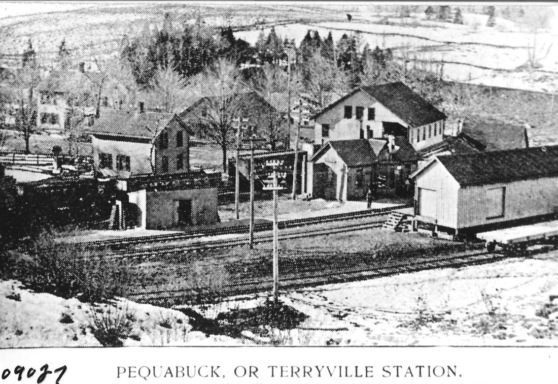
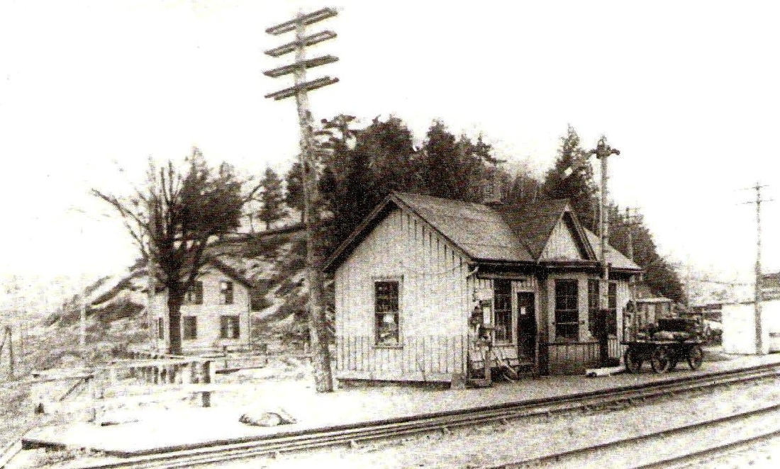
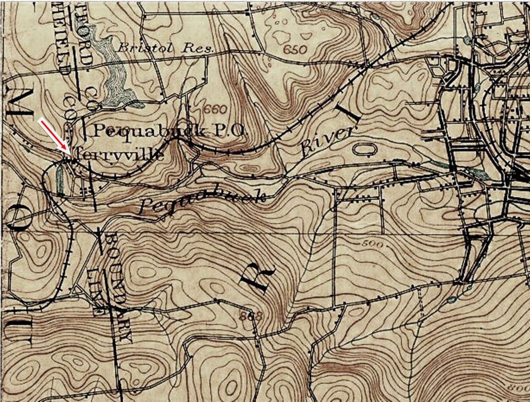
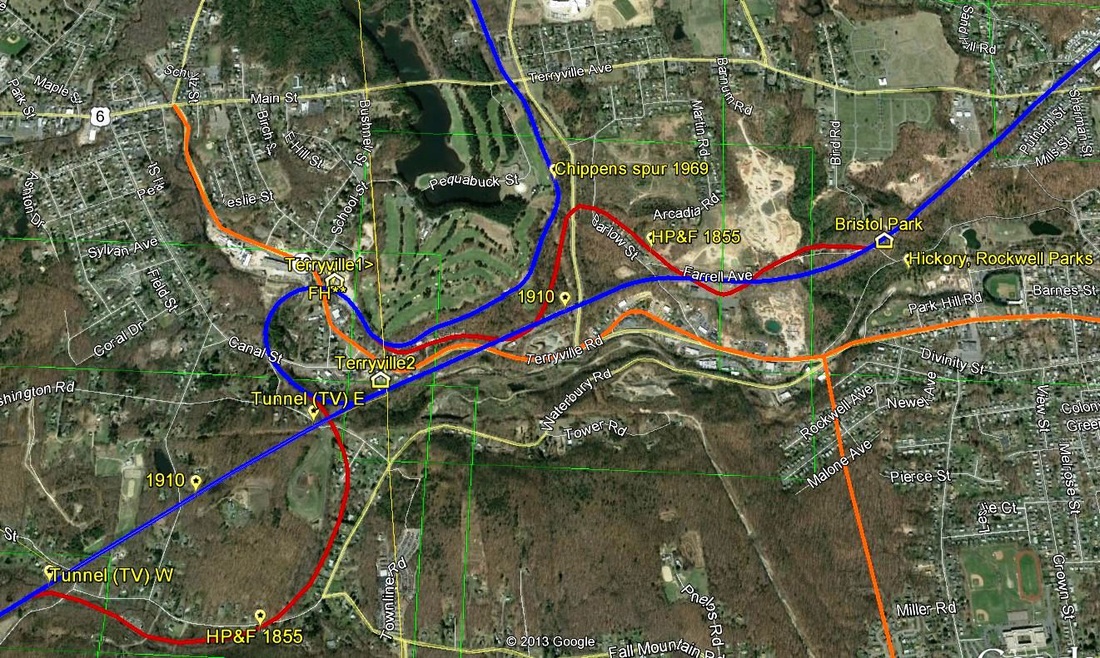
TERRYVILLE1 [HP&F, 1855; depot, 1859]
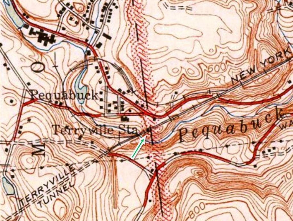
This Connecticut Courant of 11/5/1859 tells us that "a new depot has been erected by the H. P. & F. R.R. in Terryville, so that passengers need not stand in the street hereafter, while awaiting the trains." We deduce from the wording that no prior structure had existed at this stop in the town of PLYMOUTH from the 1855 opening of the HP&F line from Bristol to Waterbury. Though not cross-gabled like BRISTOL1, this board-and-batten depot is similar in style to its neighbor. The 1892 topographic map [click here] at lower middle shows the station located south of the track at our red arrow. The original, circuitous HP&F route that looped around the eastern flank of Sylvan Hill was targeted for change in 1906 when work began on a 3700-ft tunnel through the mountain. As that work was progressing in 1908, an article entitled "Terryville Wishes It Had a Bigger Station" appeared in the Courant, describing the old station as being 12x28-ft in size with a 10x12-ft waiting room, too small for a village containing between 3,000 and 4,000 inhabitants. It also claimed that it was built in 1855 with the opening of the railroad, an assumption contradicted by 1859 cited above, and it blamed the $40,000 grade-crossing elimination project west of the old station for postponing consideration of a new depot. By 1910, speculation was that passenger and freight facilities would be built on the new line but ultimately the latter were left in place on the old loop line, with TERRYVILLE1 becoming the freight office. The structure, shorn of its gable and bay window, and the freight depot, both on the north side of the loop are still in commercial use today in 2017. The 1946 topo map at lower right shows the location of TERRYVILLE2 on the new alignment heading for the tunnel. [REFS: CC/07/07/1857/02; HDC/11/04/1859/02; CC/11/05/1859/02; HPFAR10.1859.12; HPFTT 9/18/1872; HC/09/08/1891/06; HC/02/11/1905/16; HC/03/07/1905/13; HC/02/20/1908/14; HC/06/ 08/1910/13; HDC/08/03/1916/18; D132; SL12.1.29][rev021317]
This Connecticut Courant of 11/5/1859 tells us that "a new depot has been erected by the H. P. & F. R.R. in Terryville, so that passengers need not stand in the street hereafter, while awaiting the trains." We deduce from the wording that no prior structure had existed at this stop in the town of PLYMOUTH from the 1855 opening of the HP&F line from Bristol to Waterbury. Though not cross-gabled like BRISTOL1, this board-and-batten depot is similar in style to its neighbor. The 1892 topographic map [click here] at lower middle shows the station located south of the track at our red arrow. The original, circuitous HP&F route that looped around the eastern flank of Sylvan Hill was targeted for change in 1906 when work began on a 3700-ft tunnel through the mountain. As that work was progressing in 1908, an article entitled "Terryville Wishes It Had a Bigger Station" appeared in the Courant, describing the old station as being 12x28-ft in size with a 10x12-ft waiting room, too small for a village containing between 3,000 and 4,000 inhabitants. It also claimed that it was built in 1855 with the opening of the railroad, an assumption contradicted by 1859 cited above, and it blamed the $40,000 grade-crossing elimination project west of the old station for postponing consideration of a new depot. By 1910, speculation was that passenger and freight facilities would be built on the new line but ultimately the latter were left in place on the old loop line, with TERRYVILLE1 becoming the freight office. The structure, shorn of its gable and bay window, and the freight depot, both on the north side of the loop are still in commercial use today in 2017. The 1946 topo map at lower right shows the location of TERRYVILLE2 on the new alignment heading for the tunnel. [REFS: CC/07/07/1857/02; HDC/11/04/1859/02; CC/11/05/1859/02; HPFAR10.1859.12; HPFTT 9/18/1872; HC/09/08/1891/06; HC/02/11/1905/16; HC/03/07/1905/13; HC/02/20/1908/14; HC/06/ 08/1910/13; HDC/08/03/1916/18; D132; SL12.1.29][rev021317]
|
NHRHTA Collection
|
National Archives
|
|
|
|
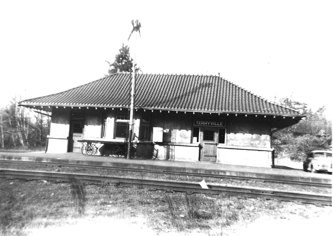
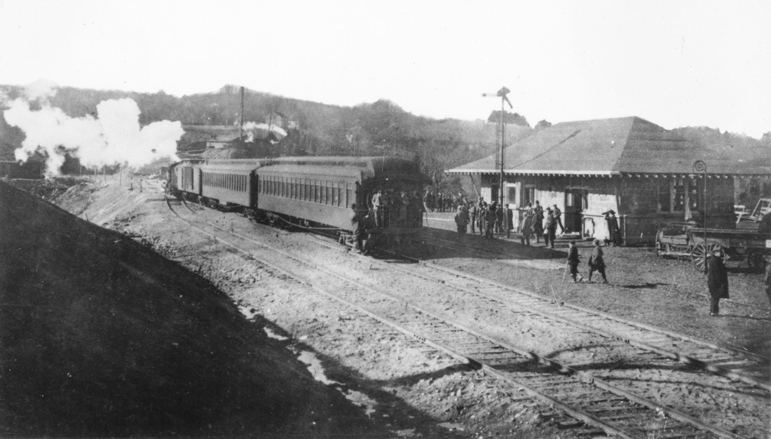
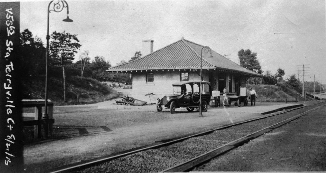
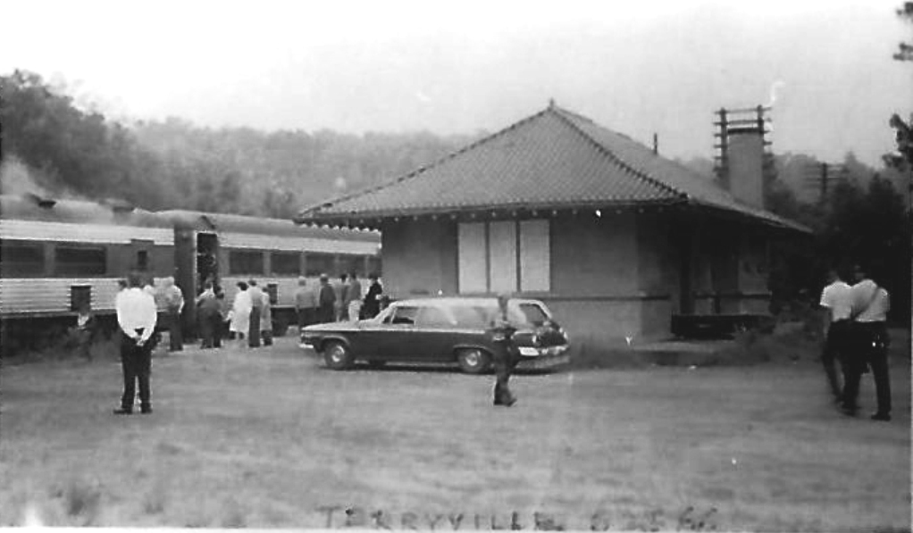
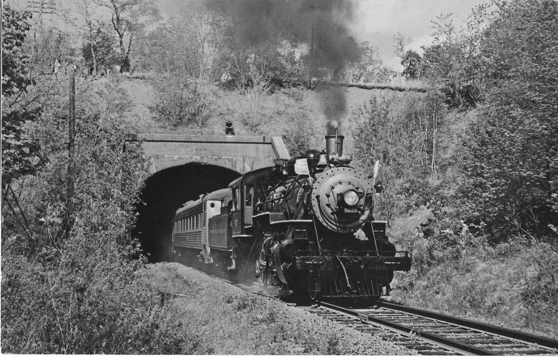
TERRYVILLE2 [NYNH&H, 1911]
The Courant announced on 1/27/1911 that the first passenger train would leave the new station at 11:33 a.m. the following morning and would mark the opening of the tunnel for regular traffic. The work, it said, was started here on 2/21/1907, abandoned on 10/31 due to the financial panic, and resumed after several months. The new passenger station was built of stucco and had a Spanish tile roof and "not ready for the full routine work at present," the paper said it would be "in a very few days." The new facility boasted hot-water heating for the waiting room, ticket, telegraph, baggage and rest rooms and the exterior grounds were to have concrete walks and crushed stone in the parking area. Just west of the new station, a connection was made to the stub-ended old main line to access the TERRYVILLE1 site where the freight facilities remained. In 1916 the loop began to be used to allow trains in Hartford-Bristol passenger service to make a convenient turnaround here. This saved the railroad from installing a turntable at Bristol after problems with the dinky engines running in reverse caused a derailment in 1914. The NYNH&H consolidated operations here in 1953 when it vacated the loop property and moved freight service down to TERRYVILLE2 until it was terminated completely in 1963. Waterbury-Hartford passenger service ended on 1/22/1960. The old loop line, later cut back to a point east of the TERRYVILLE1 site, was extended northward in 1969 up to the Chippens Hill Industrial Park that it still serves today. The city of Bristol put up $8M to entice General Motors to build a $15M plant in the park and move its New Departure-Hyatt Bearings Division there and Penn Central built the spur. According to a 1980 Courant article about restoring passenger service, TERRYVILLE2 was torn down in 1975. Its replacement would have been called Plymouth and, with additional stops at Bristol, Forestville, Plainville, New Britain and possibly Newington, the entire 1981 price tag for the 29.6-mile upgrade would have been $15M. Compare that to the 2012 cost estimate of $567M just for the 9.4-mile busway from New Britain to Hartford. Hindsight, as always, is the best teacher and foresight seems to be perennially in short supply! The only firmly datable images above are the 8/21/1916 val photo at [3] and the 8/25/1966 fan trip at [4] which shows the station boarded up after all service was discontinued in 1963. The Terryville tunnel, a vastly underrated NYNH&H engineering feat, still stands today awaiting revitalized rail service and begs for a Shoreliner piece on the historic events of its construction. [REFS: HC/06/08/1910/13; RRC29.249 (7/2/1910); HC/01/10/1911/15; HC/01/28/1911/13; NHAR40.1911.9; NHAR41.1912.10; HC/05/03/1914/05; HC/05/25/1916/12; HC/07/21/1953/22B; HC/01/23/1960/6A; HC/09/29/1963/7B1; HC/05/06/1969/23A; BP/05/21/1969/01; HC/07/14/1980/28A; D133; K84; R98][rev121013, 032622]
The Courant announced on 1/27/1911 that the first passenger train would leave the new station at 11:33 a.m. the following morning and would mark the opening of the tunnel for regular traffic. The work, it said, was started here on 2/21/1907, abandoned on 10/31 due to the financial panic, and resumed after several months. The new passenger station was built of stucco and had a Spanish tile roof and "not ready for the full routine work at present," the paper said it would be "in a very few days." The new facility boasted hot-water heating for the waiting room, ticket, telegraph, baggage and rest rooms and the exterior grounds were to have concrete walks and crushed stone in the parking area. Just west of the new station, a connection was made to the stub-ended old main line to access the TERRYVILLE1 site where the freight facilities remained. In 1916 the loop began to be used to allow trains in Hartford-Bristol passenger service to make a convenient turnaround here. This saved the railroad from installing a turntable at Bristol after problems with the dinky engines running in reverse caused a derailment in 1914. The NYNH&H consolidated operations here in 1953 when it vacated the loop property and moved freight service down to TERRYVILLE2 until it was terminated completely in 1963. Waterbury-Hartford passenger service ended on 1/22/1960. The old loop line, later cut back to a point east of the TERRYVILLE1 site, was extended northward in 1969 up to the Chippens Hill Industrial Park that it still serves today. The city of Bristol put up $8M to entice General Motors to build a $15M plant in the park and move its New Departure-Hyatt Bearings Division there and Penn Central built the spur. According to a 1980 Courant article about restoring passenger service, TERRYVILLE2 was torn down in 1975. Its replacement would have been called Plymouth and, with additional stops at Bristol, Forestville, Plainville, New Britain and possibly Newington, the entire 1981 price tag for the 29.6-mile upgrade would have been $15M. Compare that to the 2012 cost estimate of $567M just for the 9.4-mile busway from New Britain to Hartford. Hindsight, as always, is the best teacher and foresight seems to be perennially in short supply! The only firmly datable images above are the 8/21/1916 val photo at [3] and the 8/25/1966 fan trip at [4] which shows the station boarded up after all service was discontinued in 1963. The Terryville tunnel, a vastly underrated NYNH&H engineering feat, still stands today awaiting revitalized rail service and begs for a Shoreliner piece on the historic events of its construction. [REFS: HC/06/08/1910/13; RRC29.249 (7/2/1910); HC/01/10/1911/15; HC/01/28/1911/13; NHAR40.1911.9; NHAR41.1912.10; HC/05/03/1914/05; HC/05/25/1916/12; HC/07/21/1953/22B; HC/01/23/1960/6A; HC/09/29/1963/7B1; HC/05/06/1969/23A; BP/05/21/1969/01; HC/07/14/1980/28A; D133; K84; R98][rev121013, 032622]
|
|
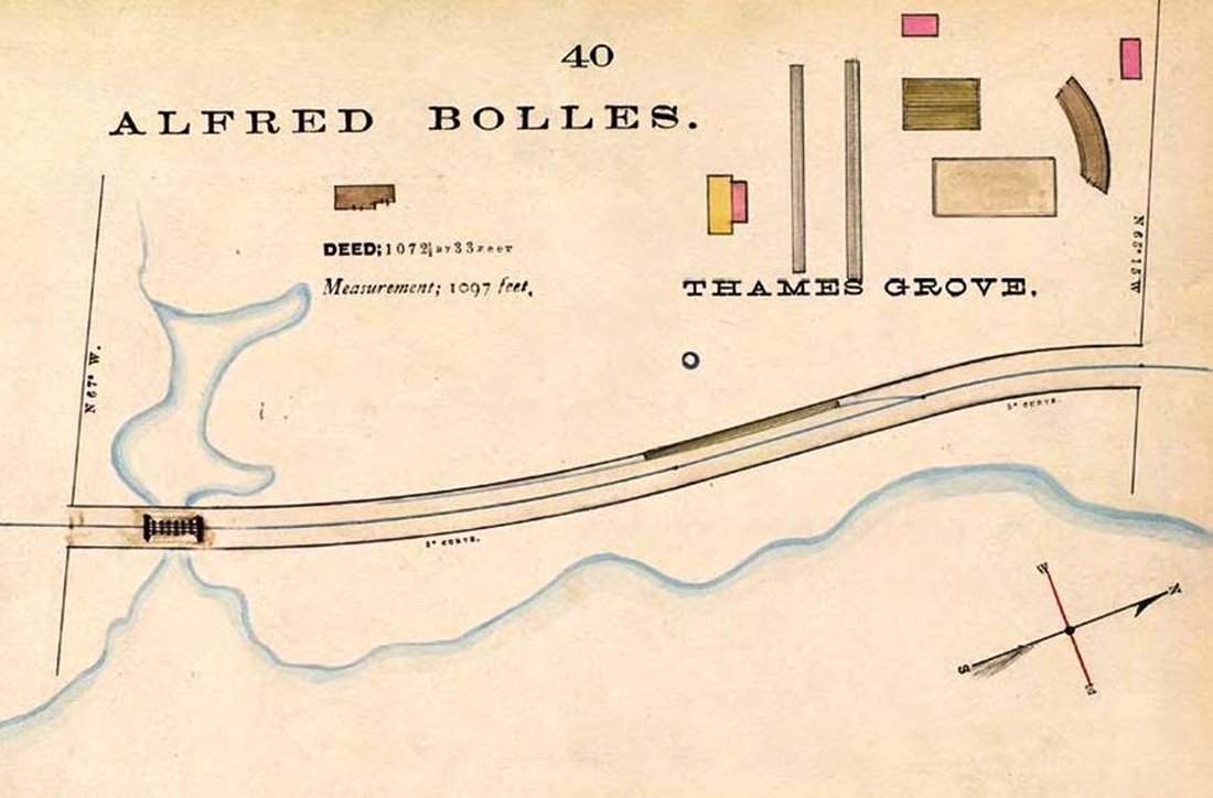
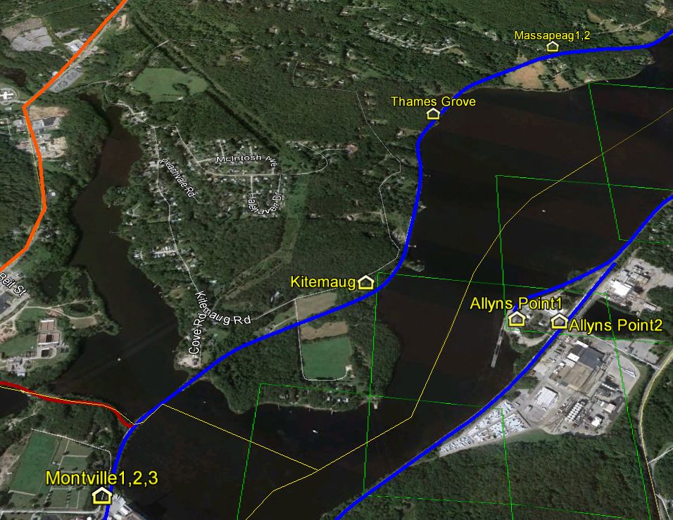
THAMES GROVE [NLN, c1859]
This stop, about 1½ miles above MONTVILLE in the town of that name, goes back to at least 1859 as BOLLES GROVE, when the newspaper reported a Sabbath School excursion by special train from New London. The 1883 NLN map [1] shows a platform and siding here, by that time at least, and Alfred Bolles as the property owner. In 1870, the NLN leased the grove and began to operate a recreational venue like the HRR's PARLOR ROCK and the NRR's HIGH ROCK GROVE. In spite of ads saying that five daily trains "passed and re-passed" daily and implying that this was a stop, the railroad commissioners reported that an accident took place on 8/5/1880 at this location, which was not "a regular or usual stopping place for trains." A Norwich-bound train was standing at the grove when a freight made a surprise approach from the rear. Though it was moving slowly and the engineer of the passenger train put on steam, the collision stove in the freight engine's boiler and eight passengers in the last passenger car were injured by the escaping steam. The freight's engineer said he had "no notice that the passenger train expected to stop at THAMES GROVE, as had been given to him of previous similar occasions." The passenger-train engine, said in one report to be the Monson, was detached by the jolt and and ran crewless and wild up to Norwich, where it was "considerably smashed" after crashing into an empty caboose. Though never seen on timetables and not a "regular" station, this was apparently a frequent train stop for Civil War regimental outings, temperance picnics, political gatherings, and regattas that would see 6,000 people arriving in 1880 at special excursion rates. A freak occurrence in 1878 saw an elederly woman, Bridget Maxwell, killed by a lightning strike in a thunderstorm which dug a crater around her body and sent an electrical shock to persons standing nearby. Newspaper references to THAMES GROVE end abruptly in 1880, coincident with with the establishment of KITEMAUG and the purchase of adjacent land to the south by that association. [REFS: NLDC/07/11/1859/02; NLDC/07/31/1860/02; NLDC/06/26/1861/02; HDC/08/08/1873/04; HDC/08/12/1874/02; NYH/07/05/1878/08; NYH/07/13/1880/06; NYH/07/21/1880/05; NYH/07/28/1880/05; HDC/08/06/1880/03; NHER/08/06/1880/01; NYT/08/06/1880/02; NHER/08/16/1880/04; NHER/12/24/1880/01; CRC28.1881.24][rev011114]
This stop, about 1½ miles above MONTVILLE in the town of that name, goes back to at least 1859 as BOLLES GROVE, when the newspaper reported a Sabbath School excursion by special train from New London. The 1883 NLN map [1] shows a platform and siding here, by that time at least, and Alfred Bolles as the property owner. In 1870, the NLN leased the grove and began to operate a recreational venue like the HRR's PARLOR ROCK and the NRR's HIGH ROCK GROVE. In spite of ads saying that five daily trains "passed and re-passed" daily and implying that this was a stop, the railroad commissioners reported that an accident took place on 8/5/1880 at this location, which was not "a regular or usual stopping place for trains." A Norwich-bound train was standing at the grove when a freight made a surprise approach from the rear. Though it was moving slowly and the engineer of the passenger train put on steam, the collision stove in the freight engine's boiler and eight passengers in the last passenger car were injured by the escaping steam. The freight's engineer said he had "no notice that the passenger train expected to stop at THAMES GROVE, as had been given to him of previous similar occasions." The passenger-train engine, said in one report to be the Monson, was detached by the jolt and and ran crewless and wild up to Norwich, where it was "considerably smashed" after crashing into an empty caboose. Though never seen on timetables and not a "regular" station, this was apparently a frequent train stop for Civil War regimental outings, temperance picnics, political gatherings, and regattas that would see 6,000 people arriving in 1880 at special excursion rates. A freak occurrence in 1878 saw an elederly woman, Bridget Maxwell, killed by a lightning strike in a thunderstorm which dug a crater around her body and sent an electrical shock to persons standing nearby. Newspaper references to THAMES GROVE end abruptly in 1880, coincident with with the establishment of KITEMAUG and the purchase of adjacent land to the south by that association. [REFS: NLDC/07/11/1859/02; NLDC/07/31/1860/02; NLDC/06/26/1861/02; HDC/08/08/1873/04; HDC/08/12/1874/02; NYH/07/05/1878/08; NYH/07/13/1880/06; NYH/07/21/1880/05; NYH/07/28/1880/05; HDC/08/06/1880/03; NHER/08/06/1880/01; NYT/08/06/1880/02; NHER/08/16/1880/04; NHER/12/24/1880/01; CRC28.1881.24][rev011114]

|

|
THAMESVILLE [NLW&P, 1849]
We just caught the corner of this station in the town of NORWICH over to the left and we are on the hunt for more. We assume there was a later station as well. The 1893 map shows the depot location in the northwest quadrant of the South St. grade crossing at that time. Based on that orientation, the photo would be looking toward the northeast.
We just caught the corner of this station in the town of NORWICH over to the left and we are on the hunt for more. We assume there was a later station as well. The 1893 map shows the depot location in the northwest quadrant of the South St. grade crossing at that time. Based on that orientation, the photo would be looking toward the northeast.
|
Connecticut Historical Society
|
Dave Peters Collection
|

Robert Lingane Collection
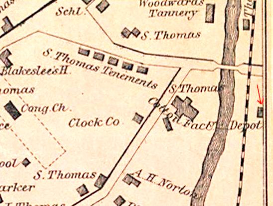
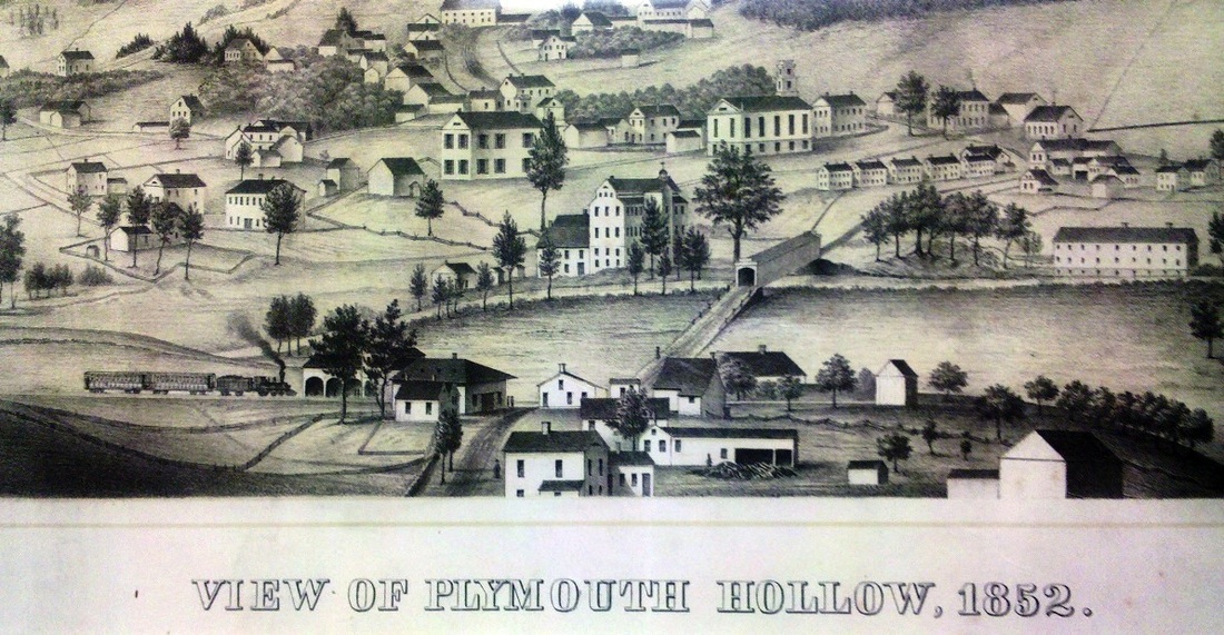
THOMASTON1 [NRR, 1849]
This station was first called PLYMOUTH HOLLOW or simply PLYMOUTH, in the town of that name as seen here on the 1854LC map at upper left and was located on the east side of the track. The snippet at middle is from an 1852 panoramic view of the village and is probably the earliest image of this station in existence. The artist was T.H. Darrow and the printer was the famed Kellogg firm of Hartford. The station, seen in the middle left foreground, was similar in design to other NRR ca. 1850 combination depots. The shot at upper right shows the structure as the freight depot after its successor was built on the opposite side of the track. THOMASTON1 lasted until 1994 when the roof collapsed under the weight of heavy snow and the ruins were removed. The val photo on the left is dated 6/15/1937. [REFS: D90; R99][rev041913]
This station was first called PLYMOUTH HOLLOW or simply PLYMOUTH, in the town of that name as seen here on the 1854LC map at upper left and was located on the east side of the track. The snippet at middle is from an 1852 panoramic view of the village and is probably the earliest image of this station in existence. The artist was T.H. Darrow and the printer was the famed Kellogg firm of Hartford. The station, seen in the middle left foreground, was similar in design to other NRR ca. 1850 combination depots. The shot at upper right shows the structure as the freight depot after its successor was built on the opposite side of the track. THOMASTON1 lasted until 1994 when the roof collapsed under the weight of heavy snow and the ruins were removed. The val photo on the left is dated 6/15/1937. [REFS: D90; R99][rev041913]

|

|
THOMASTON2 [NRR, 1881]
Damaged by an arson fire in 1993, this station was purchased by the Railroad Museum of New England which continues to restore it and uses it as the base for its tourist operations. The structure, similar in design to the 1877 WINSTED3, retains the sturdy elegance and wonderful wooden brackets born of her NRR heritage. The shot on the right is probably from the 1880s and shows the large, brick-enclosed water tank that once stood adjacent to the station. [REFS: CRC29.1882.32; CRC30.1883.20; R99][rev041913]
Damaged by an arson fire in 1993, this station was purchased by the Railroad Museum of New England which continues to restore it and uses it as the base for its tourist operations. The structure, similar in design to the 1877 WINSTED3, retains the sturdy elegance and wonderful wooden brackets born of her NRR heritage. The shot on the right is probably from the 1880s and shows the large, brick-enclosed water tank that once stood adjacent to the station. [REFS: CRC29.1882.32; CRC30.1883.20; R99][rev041913]
THOMPSON/N [> WEST THOMPSON]

THOMPSON1 [B&NYC, 1854]
This stop was established in 1854 when the B&NYC opened its East Thompson RR branch from the Massachusetts line to THOMPSON JUNCTION, aka MECHANICSVILLE, where it met the N&W. The location, as seen on the 1869 map, is in the southeast quadrant of the grade crossing. Since the next depot stood farther south, railroad-west, we assume that there was some small early structure here. We have no photo of this first depot. [add11/07/13, rrd041020]
This stop was established in 1854 when the B&NYC opened its East Thompson RR branch from the Massachusetts line to THOMPSON JUNCTION, aka MECHANICSVILLE, where it met the N&W. The location, as seen on the 1869 map, is in the southeast quadrant of the grade crossing. Since the next depot stood farther south, railroad-west, we assume that there was some small early structure here. We have no photo of this first depot. [add11/07/13, rrd041020]
|
UConn Archives & Spec. Colls.
|
Thompson Historical Society
|
|
|
|
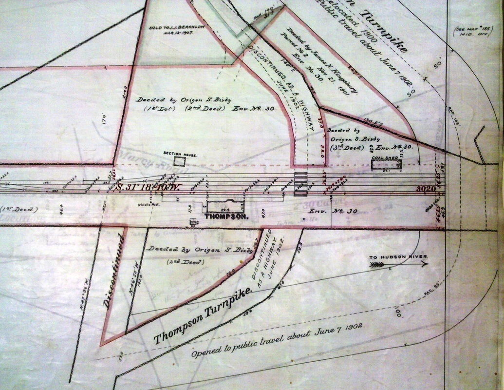
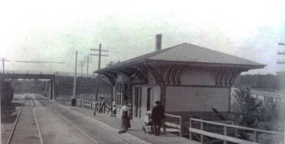
THOMPSON2 [BH&E, c1867]
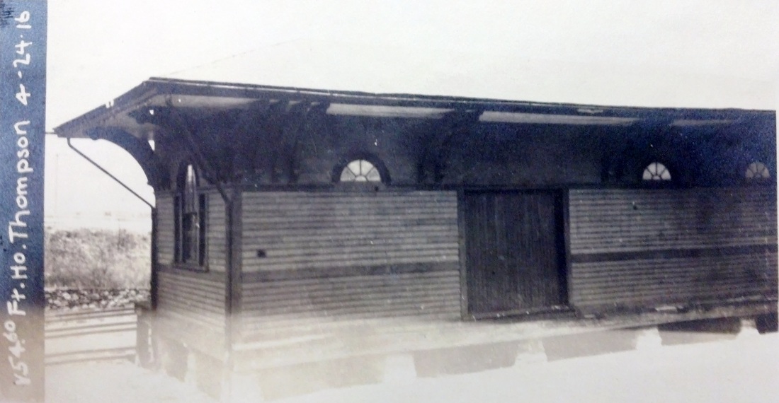
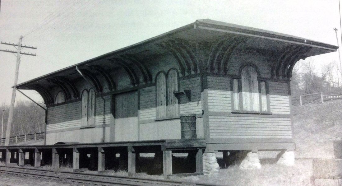
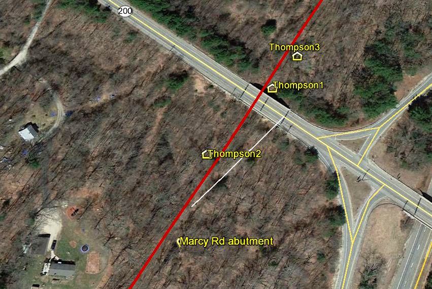
This station seems to be an exact duplicate of the 1867 QUINEBAUG station on the road's Southbridge branch and one other station we have seen at Millville, MA on this line. The view at [1] is undated but the Dutch clock in use at the far end, with '03' as part of the time when the last train passed, probably denotes the late 1800s. The 1888 map at [2] shows the location, now on the westbound side, north of the now double-tracked, and a little farther south and west from the where THOMPSON1 stood on the 1869 map in our previous listing. The shot at [3] is ca. 1902, probably right before the next depot debuted. The 4/24/1916 val photo at [4] and the 5/3/1937 shot at [5] show this structure in use as the freight depot after THOMPSON3 was built. In the Marcy Rd. grade crossing elimination project at the same time, THOMPSON2 was moved to the opposite side of the track, exact reason unknown. Windows and doors have been reconfigured, the operator's bay is gone, and the structure has been raised to move freight directly from the cars to the platform. The snippet from our Track 11 Google Earth map at [6] shows the location of the three stations here. [rev110713, 041020, 062623]
This station seems to be an exact duplicate of the 1867 QUINEBAUG station on the road's Southbridge branch and one other station we have seen at Millville, MA on this line. The view at [1] is undated but the Dutch clock in use at the far end, with '03' as part of the time when the last train passed, probably denotes the late 1800s. The 1888 map at [2] shows the location, now on the westbound side, north of the now double-tracked, and a little farther south and west from the where THOMPSON1 stood on the 1869 map in our previous listing. The shot at [3] is ca. 1902, probably right before the next depot debuted. The 4/24/1916 val photo at [4] and the 5/3/1937 shot at [5] show this structure in use as the freight depot after THOMPSON3 was built. In the Marcy Rd. grade crossing elimination project at the same time, THOMPSON2 was moved to the opposite side of the track, exact reason unknown. Windows and doors have been reconfigured, the operator's bay is gone, and the structure has been raised to move freight directly from the cars to the platform. The snippet from our Track 11 Google Earth map at [6] shows the location of the three stations here. [rev110713, 041020, 062623]
National Archives
|

National Archives
|
National Archives
|
|
|
|
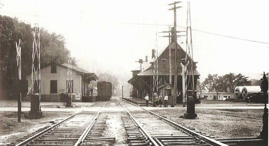
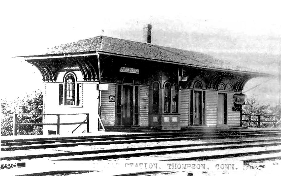
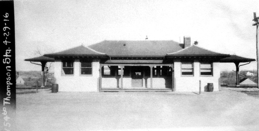
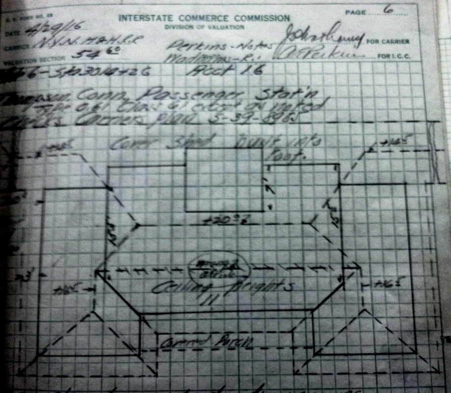
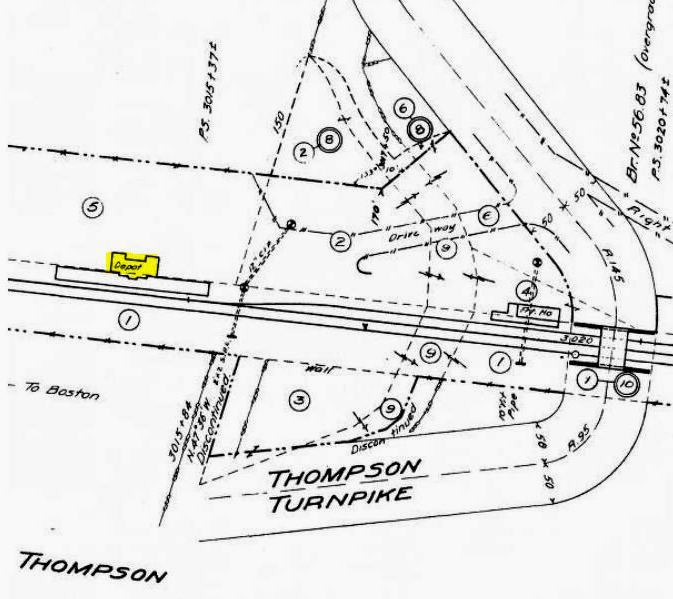
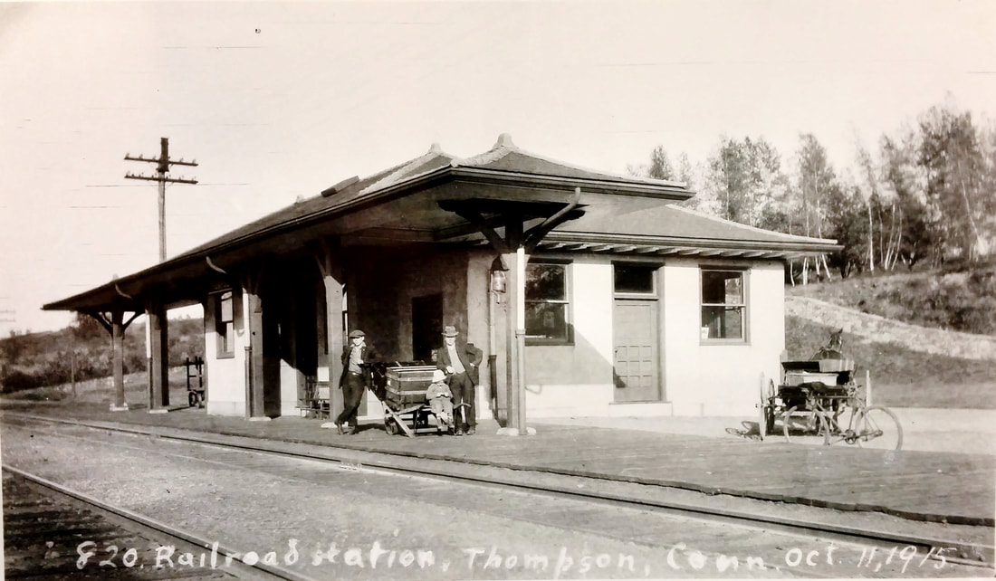
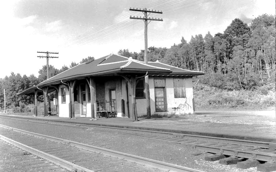
THOMPSON3 [NYNH&H, 1902]
This spiffy new depot was built farther east, a little past where THOMPSON1 stood, and farther away from the 1901 highway overpass that eliminated the old grade crossings on Thompson Tpk. and on Marcy Rd. The railroad commissioners report in December, 1902 that a new passenger station and a new freight station have also been erected there." Their language needs to be read broadly regarding the new freight house because, as we have seen above, it was merely the old passenger station relocated and renovated for freight use. The ICC valuation images in the top row are all dated 4/29/1916. The view at [1] looks south and the shot at [2] looks east toward the Marcy Rd overgrade bridge. The 6/30/1915 ICC valuation map at [4] shows the arrangement of the facilities here at that time. The photo at [5] is Louis H. Benton's #820 in a career that would see him take thousands more depot shots across New England from 1910 into the 1930s. This is one of the few that he dated, this one having been taken on 10/11/1915. The image at [6] is reportedly from 1947 and shows an aging structure. We do not know how long this station stood; the foundation is still there. The last listing we have is as a flag stop on a 9/24/1950TT and passenger service on this line was discontinued altogether after the hurricanes of 1955 washed out the Quinebaug River high bridge in Putnam. We have been able to find no reference in the railroad annual reports or any newspaper article to further clarify the opening of this station which seems to have been of an unusual, perhaps unique, architectural design. There may be backstory yet to be found! [REFS: HC/12/20/1900/10; RRC28.491 (2/13/1901); HC/02/14/1901/03; CRC50.1902.22][rev110713, 041020, 062423]
This spiffy new depot was built farther east, a little past where THOMPSON1 stood, and farther away from the 1901 highway overpass that eliminated the old grade crossings on Thompson Tpk. and on Marcy Rd. The railroad commissioners report in December, 1902 that a new passenger station and a new freight station have also been erected there." Their language needs to be read broadly regarding the new freight house because, as we have seen above, it was merely the old passenger station relocated and renovated for freight use. The ICC valuation images in the top row are all dated 4/29/1916. The view at [1] looks south and the shot at [2] looks east toward the Marcy Rd overgrade bridge. The 6/30/1915 ICC valuation map at [4] shows the arrangement of the facilities here at that time. The photo at [5] is Louis H. Benton's #820 in a career that would see him take thousands more depot shots across New England from 1910 into the 1930s. This is one of the few that he dated, this one having been taken on 10/11/1915. The image at [6] is reportedly from 1947 and shows an aging structure. We do not know how long this station stood; the foundation is still there. The last listing we have is as a flag stop on a 9/24/1950TT and passenger service on this line was discontinued altogether after the hurricanes of 1955 washed out the Quinebaug River high bridge in Putnam. We have been able to find no reference in the railroad annual reports or any newspaper article to further clarify the opening of this station which seems to have been of an unusual, perhaps unique, architectural design. There may be backstory yet to be found! [REFS: HC/12/20/1900/10; RRC28.491 (2/13/1901); HC/02/14/1901/03; CRC50.1902.22][rev110713, 041020, 062423]
THOMPSON JUNCTION [> MECHANICSVILLE]

Enfield Historical Society
|
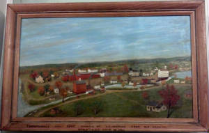
Enfield Historical Society
|

|
THOMPSONVILLE1 [H&NH, 1844]
Railroad service debuted for this Enfield village in 1844 when the line between Hartford and Springfield was opened by the H&NH, often thereafter referred to as the New Haven, Hartford & Springfield RR. We do not know what served as the first depot at this location. Perhaps it is the small white structure to the left of the brick buildings in the close-up [left] of this 1840 pastoral landscape, the oldest view we have of the area. The depot is clearly seen on the 1856WC map at right, along with the buildings of the Hartford Carpet Co which opened in 1829 and later evolved into Bigelow-Sanford [click here]. The early operation started in the tall white building seen at the west end of the mill pond in the full painting at middle. The Freshwater Brook dam created the pond, which thereafter was was used as a power source and a catch basin. In an 1891 article arguing for a more southerly location for a new station to eliminate the dangerous Main St. grade crossing, the brook was extolled as "the most remarkable body of water in America, lacking only a cataract. The color of the stream is as the hues of the solar spectrum, depending entirely upon the color of the refuse dye-stuffs that are cast into its sluggish bosom above. Boys (excepting an occasional stranger) do not bathe and its waters, therefore it is argued that people could avail themselves of the wild charms of this road without offending the proprieties." So much for life with the industrial pollution that was so common in the 1800s. [REFS: SR/11/01/1891/03][rev011514]
Railroad service debuted for this Enfield village in 1844 when the line between Hartford and Springfield was opened by the H&NH, often thereafter referred to as the New Haven, Hartford & Springfield RR. We do not know what served as the first depot at this location. Perhaps it is the small white structure to the left of the brick buildings in the close-up [left] of this 1840 pastoral landscape, the oldest view we have of the area. The depot is clearly seen on the 1856WC map at right, along with the buildings of the Hartford Carpet Co which opened in 1829 and later evolved into Bigelow-Sanford [click here]. The early operation started in the tall white building seen at the west end of the mill pond in the full painting at middle. The Freshwater Brook dam created the pond, which thereafter was was used as a power source and a catch basin. In an 1891 article arguing for a more southerly location for a new station to eliminate the dangerous Main St. grade crossing, the brook was extolled as "the most remarkable body of water in America, lacking only a cataract. The color of the stream is as the hues of the solar spectrum, depending entirely upon the color of the refuse dye-stuffs that are cast into its sluggish bosom above. Boys (excepting an occasional stranger) do not bathe and its waters, therefore it is argued that people could avail themselves of the wild charms of this road without offending the proprieties." So much for life with the industrial pollution that was so common in the 1800s. [REFS: SR/11/01/1891/03][rev011514]

|

|
|

Enfield Historical Society
|
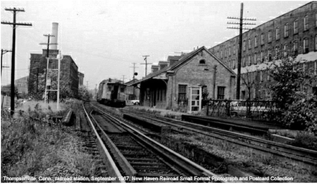
|
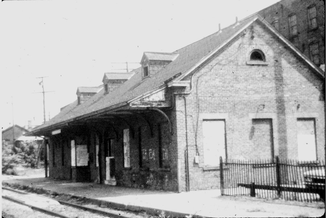
|
 National Archives
THOMPSONVILLE2 [H&NH, c1870]
A photograph in the collections of the Enfield Historical Society [click here] gives 1854 for the start of railroad service, 1857 as the date this station was built, and 1947 as the date it was razed. The first date is patently incorrect, the second date is unverified and newly discounted, and the last date is inaccurate both in time and what actually took place. Based on its similarity to WAREHOUSE POINT2, this depot must have a c1870 build date and perhaps the same Charlie Lord who fell off the ladder there in 1869 was involved here as well. One fugitive reference gives an 1867 build date, which may be correct. The hugely profitable and well-respected H&NH was engaged in several construction projects at the time, including new repair shops at Hartford and new stations at WINDSOR and WALLINGFORD. Image [1] is undated but shows the two-story depot as built, with the Hartford Carpet Co., so-called until 1901, in the background. The 1893 map [2] shows the station at the red arrow, in the same location as the map in our previous entry. Image [3] is a Lewis H. Benton shot #2356 from the 1930s, with fellow photographer Irving N. Drake posing and his sedan nowhere to be seen. As to THOMPSONVILLE2 being razed, we have been able to document that this was not the case. A July, 1945 Thompsonville Press article reads, in part: "Depot Here to Be Remodeled.... The entire second story of the present structure, now occupied as a tenement, is to be removed. The remodeled one story depot will have a peaked roof, with three dormer windows in the east side. The main entrance will be from Commerce street... The ticket office, now located on the Commerce street side, will be removed to the track side of the station, with a bay window toward the station platform, and with the adjoining telegraph office will extend across the north end of the waiting room... The present wooden addition at the north end of the depot, occupied by the Railway Express office ... will be torn down and will be replaced by larger express office of brick construction, matching the main building." A subsequent photograph in the Press had captioning which said that "upon completion, the Thomsonville Station is expected to be one of the most attractive of the Stations along the right of way of the New Haven Railroad." The lower tier shows the remodeled station, which must have been completed in 1946. Photo [4] is captioned as the 'new' station, [5] shows a freight train passing in September, 1967, [6] shows the station boarded up, reportedly in 1974, and the val photo [7] is a throw-back to 8/11/1916 when the station had its upper story. Cut-backs to service in later days led to an interesting situation here in 1959. Train 62, a single Budd car running daily from New Haven to Springfield was cancelled by the railroad as being too expensive but was reinstated by PUC order. However, the NYNH&H retaliated by terminating the train here at the last Connecticut stop over which the agency had jurisdiction and making passengers wait for another train to come down from Springfield! Penn Central would close the station in 1971 and a January, 1974 Courant article said that "the more than 40 riders that board Amtrak's Connecticut Yankee for Hartford at Thompsonville Station each morning must wait in the dark." Repeated vandalism and a 1/26/1980 fire prompted Amtrak, the new owner after creation of Conrail in 1976, to opt for razing the passenger and freight stations but, after objections and the possibility of inclusion of the structures in an NRHP designation for the adjacent Bigelow-Sanford complex, it remained standing until early 1983 when Amtrak condemned them and tore down both. The factory complex survives today as the Bigelow-Hartford Carpet Mills Historic District which was given an NRHP designation on 11/25/1994. [REFS: HDC/11/09/1869/02; HC/01/12/1911/13; HC/03/25/1914/07; HC/02/27/1916/02; HC/01/09/1916/05; TP/07/19/1945/01; TP/08/23/1945/01; HC/08/12/1972/17C; HC/10/24/1966/16C; HC/08/12/1972/17C; HC/01/23/1974/58C; HC/07/16/1976/63; HC/01/28/1980/18B; HC/01/30/1980/13D; HC/02/14/1980/35C; HC/01/07/1983/B3C; HC/04/03/1986/E13qqq: 1867 build date; NRIS ID 94001392][rev100518; 060222]
A photograph in the collections of the Enfield Historical Society [click here] gives 1854 for the start of railroad service, 1857 as the date this station was built, and 1947 as the date it was razed. The first date is patently incorrect, the second date is unverified and newly discounted, and the last date is inaccurate both in time and what actually took place. Based on its similarity to WAREHOUSE POINT2, this depot must have a c1870 build date and perhaps the same Charlie Lord who fell off the ladder there in 1869 was involved here as well. One fugitive reference gives an 1867 build date, which may be correct. The hugely profitable and well-respected H&NH was engaged in several construction projects at the time, including new repair shops at Hartford and new stations at WINDSOR and WALLINGFORD. Image [1] is undated but shows the two-story depot as built, with the Hartford Carpet Co., so-called until 1901, in the background. The 1893 map [2] shows the station at the red arrow, in the same location as the map in our previous entry. Image [3] is a Lewis H. Benton shot #2356 from the 1930s, with fellow photographer Irving N. Drake posing and his sedan nowhere to be seen. As to THOMPSONVILLE2 being razed, we have been able to document that this was not the case. A July, 1945 Thompsonville Press article reads, in part: "Depot Here to Be Remodeled.... The entire second story of the present structure, now occupied as a tenement, is to be removed. The remodeled one story depot will have a peaked roof, with three dormer windows in the east side. The main entrance will be from Commerce street... The ticket office, now located on the Commerce street side, will be removed to the track side of the station, with a bay window toward the station platform, and with the adjoining telegraph office will extend across the north end of the waiting room... The present wooden addition at the north end of the depot, occupied by the Railway Express office ... will be torn down and will be replaced by larger express office of brick construction, matching the main building." A subsequent photograph in the Press had captioning which said that "upon completion, the Thomsonville Station is expected to be one of the most attractive of the Stations along the right of way of the New Haven Railroad." The lower tier shows the remodeled station, which must have been completed in 1946. Photo [4] is captioned as the 'new' station, [5] shows a freight train passing in September, 1967, [6] shows the station boarded up, reportedly in 1974, and the val photo [7] is a throw-back to 8/11/1916 when the station had its upper story. Cut-backs to service in later days led to an interesting situation here in 1959. Train 62, a single Budd car running daily from New Haven to Springfield was cancelled by the railroad as being too expensive but was reinstated by PUC order. However, the NYNH&H retaliated by terminating the train here at the last Connecticut stop over which the agency had jurisdiction and making passengers wait for another train to come down from Springfield! Penn Central would close the station in 1971 and a January, 1974 Courant article said that "the more than 40 riders that board Amtrak's Connecticut Yankee for Hartford at Thompsonville Station each morning must wait in the dark." Repeated vandalism and a 1/26/1980 fire prompted Amtrak, the new owner after creation of Conrail in 1976, to opt for razing the passenger and freight stations but, after objections and the possibility of inclusion of the structures in an NRHP designation for the adjacent Bigelow-Sanford complex, it remained standing until early 1983 when Amtrak condemned them and tore down both. The factory complex survives today as the Bigelow-Hartford Carpet Mills Historic District which was given an NRHP designation on 11/25/1994. [REFS: HDC/11/09/1869/02; HC/01/12/1911/13; HC/03/25/1914/07; HC/02/27/1916/02; HC/01/09/1916/05; TP/07/19/1945/01; TP/08/23/1945/01; HC/08/12/1972/17C; HC/10/24/1966/16C; HC/08/12/1972/17C; HC/01/23/1974/58C; HC/07/16/1976/63; HC/01/28/1980/18B; HC/01/30/1980/13D; HC/02/14/1980/35C; HC/01/07/1983/B3C; HC/04/03/1986/E13qqq: 1867 build date; NRIS ID 94001392][rev100518; 060222]
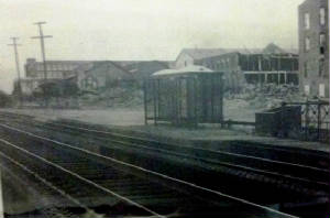
Enfield Historical Society
THOMPSONVILLE3 [ATK, 1980]
These twin shelters may have been put up for the 10/26/1980 inauguration of Amtrak service when a similar one was installed in NORTH HAVEN. Exactly six years later on 10/26/1986, Amtrak discontinued service, citing the fact that 1,723 passengers, or fewer than five per day, used the eight daily trains stopping at what was now called ENFIELD. Fourteen years later there was talk of restoring the stop, which may finally come to fruition with the upgrade of the Springfield line that is currently spoken of in 2012. [REFS: HC/04/03/1986/CE1; HC/10/02/1986/C6; HC/10/12/2000/B1][rev060222]
These twin shelters may have been put up for the 10/26/1980 inauguration of Amtrak service when a similar one was installed in NORTH HAVEN. Exactly six years later on 10/26/1986, Amtrak discontinued service, citing the fact that 1,723 passengers, or fewer than five per day, used the eight daily trains stopping at what was now called ENFIELD. Fourteen years later there was talk of restoring the stop, which may finally come to fruition with the upgrade of the Springfield line that is currently spoken of in 2012. [REFS: HC/04/03/1986/CE1; HC/10/02/1986/C6; HC/10/12/2000/B1][rev060222]