Track 12: CT Passenger Stations, S-SM
See TCS Home Page links for notes, abbreviations, and sources.
Use Track 11 map link to locate stations, rail and trolley lines, and POIs.
Use Track 11 map link to locate stations, rail and trolley lines, and POIs.

SACHEMS HEAD1 [NYP&B, 1859]
The Register reported in 1859 that... "a new depot is to be established on the Railroad near the Sachem's Head House," a summer resort in the town of Guilford. The new proprietor of what had been a venerable establishment since the 1830s, was H. Lee Scranton who also owned the fashionable Tontine Hotel in New Haven. A clever entrepreneur who understood the power of marketing, he advertised in Washington, D.C., the South, and Ohio to bring people to 'The Head' where he was fond of saying "no mosquito biteth and every scene delighteth." As early as April the papers echoed each other in reporting that the hotel was "situated one mile from the 'Sachems Head Station,' on the Providence and Stonington RR, on which guests have the privilege of Excursion tickets at half price to and from the Tontine Hotel [New Haven]." It was the NYP&B, in fact, that was running the line at this time and apparently willing to cooperate with Scranton to mutual advantage. On 6/6/1859 omnibuses began to meet trains to take guests to the hotel and newspaper timetables show this service renewed through late October, thus establishing a more or less permanent stop though one likely linked to the fortunes of the hotel. Several articles, one in 1861 particularly, imply or mention a depot, leading us to conclude that Scranton built a structure here. The hotel burned in 1865 and was not rebuilt until ten years later. This perhaps explains why nothing shows on the Beers map in 1868, though small flag stops, especially seasonal ones, were often overlooked. It would not be until the 1890s that this stop shows up on official timetables. Nevertheless, a station lasting over 60 years had been established through the joint collaboration of a skillful business man and a railroad interested in accommodating the public and increasing revenue. [REFS: CR/05/07/1859/02; CPD/05/16/1859/01; AC/05/11/1859/02; CR/05/07/1859/02; CR/09/07/1861/04; SR/04/21/1863/04][rev110214, 043023]
The Register reported in 1859 that... "a new depot is to be established on the Railroad near the Sachem's Head House," a summer resort in the town of Guilford. The new proprietor of what had been a venerable establishment since the 1830s, was H. Lee Scranton who also owned the fashionable Tontine Hotel in New Haven. A clever entrepreneur who understood the power of marketing, he advertised in Washington, D.C., the South, and Ohio to bring people to 'The Head' where he was fond of saying "no mosquito biteth and every scene delighteth." As early as April the papers echoed each other in reporting that the hotel was "situated one mile from the 'Sachems Head Station,' on the Providence and Stonington RR, on which guests have the privilege of Excursion tickets at half price to and from the Tontine Hotel [New Haven]." It was the NYP&B, in fact, that was running the line at this time and apparently willing to cooperate with Scranton to mutual advantage. On 6/6/1859 omnibuses began to meet trains to take guests to the hotel and newspaper timetables show this service renewed through late October, thus establishing a more or less permanent stop though one likely linked to the fortunes of the hotel. Several articles, one in 1861 particularly, imply or mention a depot, leading us to conclude that Scranton built a structure here. The hotel burned in 1865 and was not rebuilt until ten years later. This perhaps explains why nothing shows on the Beers map in 1868, though small flag stops, especially seasonal ones, were often overlooked. It would not be until the 1890s that this stop shows up on official timetables. Nevertheless, a station lasting over 60 years had been established through the joint collaboration of a skillful business man and a railroad interested in accommodating the public and increasing revenue. [REFS: CR/05/07/1859/02; CPD/05/16/1859/01; AC/05/11/1859/02; CR/05/07/1859/02; CR/09/07/1861/04; SR/04/21/1863/04][rev110214, 043023]
|

|
New Haven Museum
|
SACHEMS HEAD2 [NYNH&H, 1883; depot 1894?]
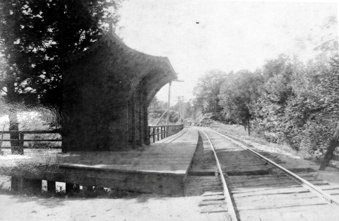
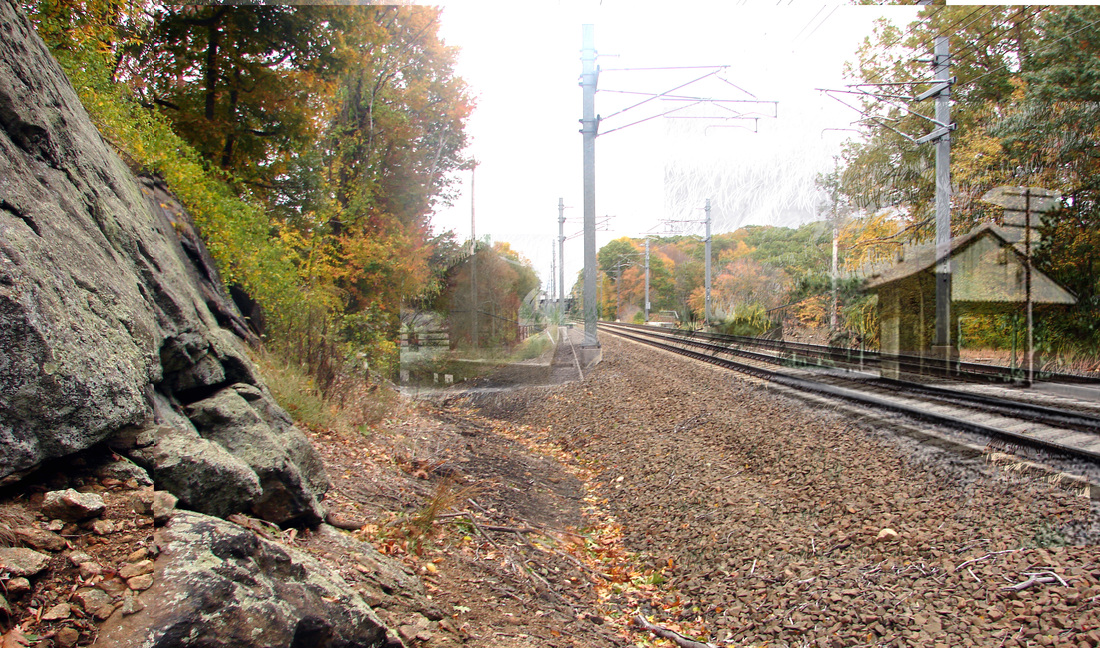
The Register reported in June, 1883 that "the depot platform at Sachem Head is nearly completed" but whether that included the small but ornate structure seen here is a bit of a mystery because neither depot nor platform is seen on the 1892 ROW atlas plate at [3]. This stylish little station is virtually identical to PINE ORCHARD1 that we know was built in 1885 by the NYNH&H. It seems fair to assume that its twin here was built likely also by the railroad and took the place of the Scranton depot. If it were built in 1894, as suggested on the real estate card in the next entry, that would explain why it is not on the 1892 map. The shot at [1] looks east with SACHEMS HEAD2 on the north side of the track, with tie removed and fencing (at extreme right) to deter livestock from trespassing. The fact that is still a single track indicates that it predates the double-tracking of 1891-1892. The image at [2] shows the rock highlighted by Al Weaver's colorization in its proper location in the northwest quadrant of the old grade crossing. [REFS: NHER/06/12/1883/04; NHER/04/11/1888/02; CRC36.1888.34; 1894TT: yes][rev110214, 043023]
The Register reported in June, 1883 that "the depot platform at Sachem Head is nearly completed" but whether that included the small but ornate structure seen here is a bit of a mystery because neither depot nor platform is seen on the 1892 ROW atlas plate at [3]. This stylish little station is virtually identical to PINE ORCHARD1 that we know was built in 1885 by the NYNH&H. It seems fair to assume that its twin here was built likely also by the railroad and took the place of the Scranton depot. If it were built in 1894, as suggested on the real estate card in the next entry, that would explain why it is not on the 1892 map. The shot at [1] looks east with SACHEMS HEAD2 on the north side of the track, with tie removed and fencing (at extreme right) to deter livestock from trespassing. The fact that is still a single track indicates that it predates the double-tracking of 1891-1892. The image at [2] shows the rock highlighted by Al Weaver's colorization in its proper location in the northwest quadrant of the old grade crossing. [REFS: NHER/06/12/1883/04; NHER/04/11/1888/02; CRC36.1888.34; 1894TT: yes][rev110214, 043023]
Guilford Free Library
|
|
|
 Guilford Free Library
SACHEMS HEAD3 [NYNH&H, 1901]
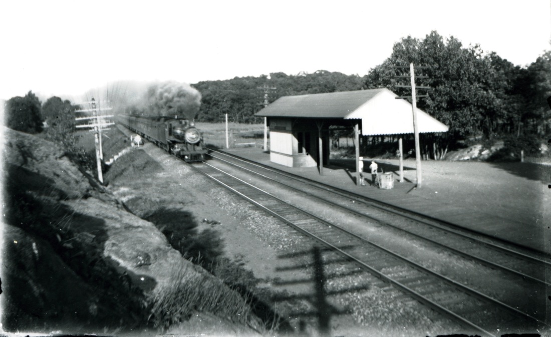
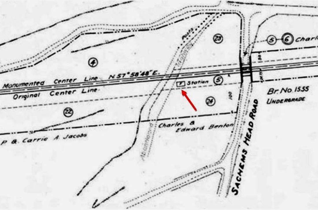
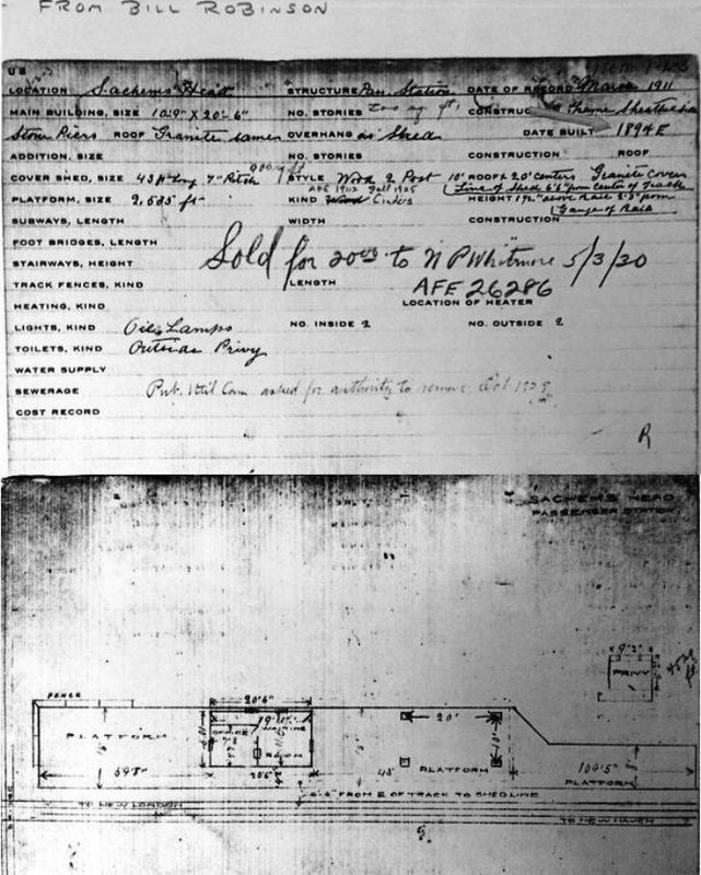
The railroad commissioners reported that this station went up in 1901 and the newspapers corroborate that the new depot was finished by the end of October. The view at [1] shows it ca. 1907 and the 6/30/1915 ICC valuation map at [2] indicates the location of the 'F'=frame, wood structure at our red arrow. The shot at [3] is Al Weaver's eastward-looking, ghost superimposition of this station at right and the prrevious one on the left. Note the rock in the left foreground that is mentioned in our preceding entry. Interestingly, the 1911 NYNH&H real estate record card at [4] gives an 1894 build date that likely is attributable to SACHEMS HEAD2, not SACHEMS HEAD3. The map on the reverse shows SACHEMS HEAD3 to have been a 11x20-ft depot with a small office and passenger waiting room. The privy is a separate building located to the west and the station has coversheds to protect people from the elements while waiting for the train. The card also tells us that this depot was was sold for $20 to N.P. Whitmore on 5/3/1930 and, since this station no longer shows up on late 1920s timetables, passenger service at this stop likely had ended by then. [REFS: CRC49.1901.19; SLT/04/21/1901/01; SR/10/31/1901/12; HC/10/29/1901/05; AFE26286 (1930)][rev110214, 043023]
The railroad commissioners reported that this station went up in 1901 and the newspapers corroborate that the new depot was finished by the end of October. The view at [1] shows it ca. 1907 and the 6/30/1915 ICC valuation map at [2] indicates the location of the 'F'=frame, wood structure at our red arrow. The shot at [3] is Al Weaver's eastward-looking, ghost superimposition of this station at right and the prrevious one on the left. Note the rock in the left foreground that is mentioned in our preceding entry. Interestingly, the 1911 NYNH&H real estate record card at [4] gives an 1894 build date that likely is attributable to SACHEMS HEAD2, not SACHEMS HEAD3. The map on the reverse shows SACHEMS HEAD3 to have been a 11x20-ft depot with a small office and passenger waiting room. The privy is a separate building located to the west and the station has coversheds to protect people from the elements while waiting for the train. The card also tells us that this depot was was sold for $20 to N.P. Whitmore on 5/3/1930 and, since this station no longer shows up on late 1920s timetables, passenger service at this stop likely had ended by then. [REFS: CRC49.1901.19; SLT/04/21/1901/01; SR/10/31/1901/12; HC/10/29/1901/05; AFE26286 (1930)][rev110214, 043023]
Archives & Special Collections, UConn
|
|
Max Miller Collection
|
National Archives
SADDS MILLS [CC, 1876]
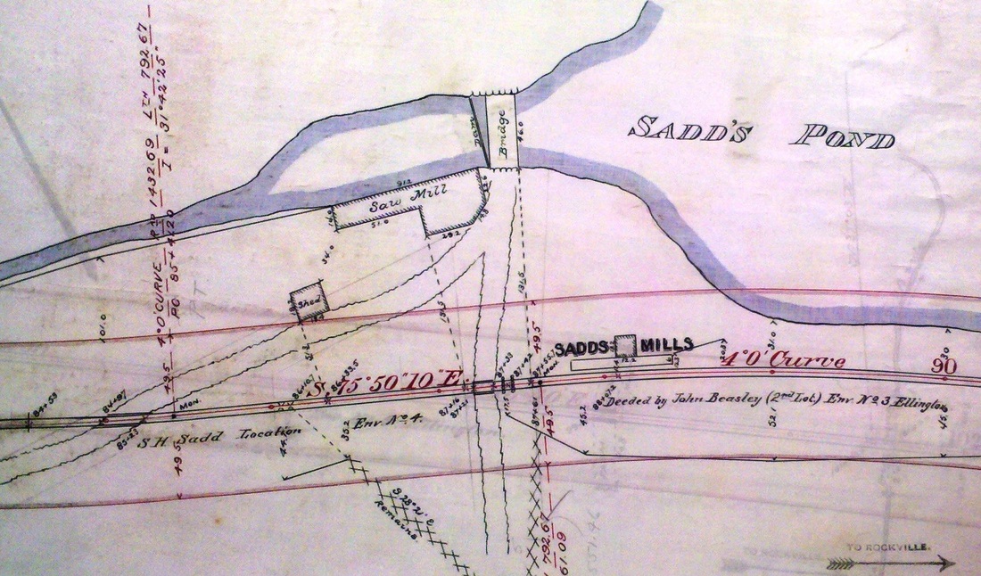
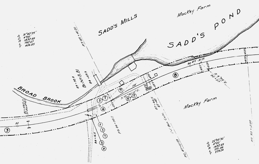
This was a flag stop in the town of Ellington on the 1876 Connecticut Central RR from MELROSE to WESTWAY where it intersected with the Rockville RR. Both of these came to the NYNH#H when it subsumed the NY&NE in 1898 The railroad commissioners were to inspect the CC on 10/5/1876 and presumably gave their approval shortly thereafter. The real estate map at [1] dates to 1888. It shows a 12-ft square depot structure, fronted by a platform perhaps 50 feet in length and standing east of the track and south of Broad Brook Rd. At the time the 6/30/1915 val map at [2] was created, the depot is standing at the end of a 298-ft siding. It appears to be in its original location vis-a-vis the dam for the mill at Sadds Pond. The structure is seen in the 8/9/1916 ICC valuation photo at [4] in a shot looking toward the pond. Passenger service on the branch was gone by 1928, due in part to the competing trolley line that opened in 1907. In an unsuccessful effort to compete, the NYNH&H had electrified the Melrose Branch but ultimately took over the trolley line as well. A 1936 flood would wash out track here and the PUC would allow abandonment of the SADDS MILLS station as of 8/11/1937 and shortly thereafter, the branch from ELLINGTON to MELROSE was abandoned as of 11/31/1937. The portion of the line from WESTWAY to ELLINGTON lasted until 1963. Since it does not appear on the 1938 SSRR, the station structure appears to have been already removed by then. The snippet at [3] is from out Track 11 Google Earth map and shows where the site is today. [REFS: HDC/10/04/1876/01; SR/03/07/1888/06; SR/10/05/1890/06; SR/10/15/1890/05; RAM1908; PUC Dkt 3499, 6636; ICC Finance Dkt 11756; K120][rev102218, 043023]
This was a flag stop in the town of Ellington on the 1876 Connecticut Central RR from MELROSE to WESTWAY where it intersected with the Rockville RR. Both of these came to the NYNH#H when it subsumed the NY&NE in 1898 The railroad commissioners were to inspect the CC on 10/5/1876 and presumably gave their approval shortly thereafter. The real estate map at [1] dates to 1888. It shows a 12-ft square depot structure, fronted by a platform perhaps 50 feet in length and standing east of the track and south of Broad Brook Rd. At the time the 6/30/1915 val map at [2] was created, the depot is standing at the end of a 298-ft siding. It appears to be in its original location vis-a-vis the dam for the mill at Sadds Pond. The structure is seen in the 8/9/1916 ICC valuation photo at [4] in a shot looking toward the pond. Passenger service on the branch was gone by 1928, due in part to the competing trolley line that opened in 1907. In an unsuccessful effort to compete, the NYNH&H had electrified the Melrose Branch but ultimately took over the trolley line as well. A 1936 flood would wash out track here and the PUC would allow abandonment of the SADDS MILLS station as of 8/11/1937 and shortly thereafter, the branch from ELLINGTON to MELROSE was abandoned as of 11/31/1937. The portion of the line from WESTWAY to ELLINGTON lasted until 1963. Since it does not appear on the 1938 SSRR, the station structure appears to have been already removed by then. The snippet at [3] is from out Track 11 Google Earth map and shows where the site is today. [REFS: HDC/10/04/1876/01; SR/03/07/1888/06; SR/10/05/1890/06; SR/10/15/1890/05; RAM1908; PUC Dkt 3499, 6636; ICC Finance Dkt 11756; K120][rev102218, 043023]
|
|
|
SALISBURY1 [CW, 1871]
The Connecticut Western News said in November, 1871 that "Messrs. Bundy & Levi who have nearly completed the depots in Lakeville, have brought their men to Salisbury and are at work on those for this village." G.F. Bundy of Lakeville was the well-respected general contractor and carpenter who also built CANAAN2, the 1872 union station at the CW's junction with the HRR. Though no photographs of LAKEVILLE1 or SALISBURY1 have yet been found, a newspaper article said that they were "so nearly alike that the difference between the two is scarcely perceptible." Inside of each was a "commodious ladies' parlor at one end, and an equally large and neatly arranged waiting room for gentlemen at the other, with a convenient office for agents and a room for baggage between the two." Cornice plaster moldings, hard-finish walls and high ceilings seem to indicate a degree of elegance here and at Lakeville that we do not see in other CW stations. Bundy was certainly responsible for the fine workmanship and perhaps the design as well, and we are inclined to think that his passenger stations were small, gabled structures like his 20x32-ft freight stations, Salisbury pictured above at middle and Lakeville to the right. A December article reported: "Salisbury Depots. -- These depots are now slated [i.e. roofed], and enclosed on all sides and painted. They will soon be ready for the masons." The 1874 Beers map at left shows the location of the station in the center of the village. The 1880 NY&NE appraisal of CW assets said the passenger station here was in good condition and was substantial enough to be valued at $1400, making it comparable in worth to BLOOMFIELD and CANTON, each given at $1500. This station burned on 1/12/1893 and seven days later the next issue of the News wrote: "The railroad depot of this village was burned last Thursday night. All the books and papers, also some money and clothing beloning (sic) to Agent Bennett were burned. Young Bennett, who is night operator, gave the alarm, but the fire was under such headway that it could not be extinguished, so he started for the telegraph office at Chapinville and Agent Bennett for Lakeville to send messages necessary to avoid any accident to trains. The fire is supposed to have been occasioned by some defect in the chimney. Supt. Blaine and other officials were in town on Friday. A small building has been erected for present use. It is hoped that our worthy employees will not be obliged to sustain any loss." To our knowledge, no photo of SALISBURY1 has yet been found. [REFS: CWN/09/01/1871/03; CWN/11/24/1871/02; CWN/12/08/1871/02; HDC/12/14/1871/02; CW/NYNE1880; CWN/01/19/1893/02; CWN/10/05/1893/02] [rev061613, 050123]
The Connecticut Western News said in November, 1871 that "Messrs. Bundy & Levi who have nearly completed the depots in Lakeville, have brought their men to Salisbury and are at work on those for this village." G.F. Bundy of Lakeville was the well-respected general contractor and carpenter who also built CANAAN2, the 1872 union station at the CW's junction with the HRR. Though no photographs of LAKEVILLE1 or SALISBURY1 have yet been found, a newspaper article said that they were "so nearly alike that the difference between the two is scarcely perceptible." Inside of each was a "commodious ladies' parlor at one end, and an equally large and neatly arranged waiting room for gentlemen at the other, with a convenient office for agents and a room for baggage between the two." Cornice plaster moldings, hard-finish walls and high ceilings seem to indicate a degree of elegance here and at Lakeville that we do not see in other CW stations. Bundy was certainly responsible for the fine workmanship and perhaps the design as well, and we are inclined to think that his passenger stations were small, gabled structures like his 20x32-ft freight stations, Salisbury pictured above at middle and Lakeville to the right. A December article reported: "Salisbury Depots. -- These depots are now slated [i.e. roofed], and enclosed on all sides and painted. They will soon be ready for the masons." The 1874 Beers map at left shows the location of the station in the center of the village. The 1880 NY&NE appraisal of CW assets said the passenger station here was in good condition and was substantial enough to be valued at $1400, making it comparable in worth to BLOOMFIELD and CANTON, each given at $1500. This station burned on 1/12/1893 and seven days later the next issue of the News wrote: "The railroad depot of this village was burned last Thursday night. All the books and papers, also some money and clothing beloning (sic) to Agent Bennett were burned. Young Bennett, who is night operator, gave the alarm, but the fire was under such headway that it could not be extinguished, so he started for the telegraph office at Chapinville and Agent Bennett for Lakeville to send messages necessary to avoid any accident to trains. The fire is supposed to have been occasioned by some defect in the chimney. Supt. Blaine and other officials were in town on Friday. A small building has been erected for present use. It is hoped that our worthy employees will not be obliged to sustain any loss." To our knowledge, no photo of SALISBURY1 has yet been found. [REFS: CWN/09/01/1871/03; CWN/11/24/1871/02; CWN/12/08/1871/02; HDC/12/14/1871/02; CW/NYNE1880; CWN/01/19/1893/02; CWN/10/05/1893/02] [rev061613, 050123]
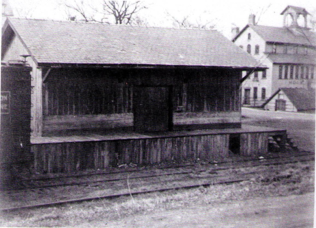
SALISBURY2 [PR&NE, 1893]
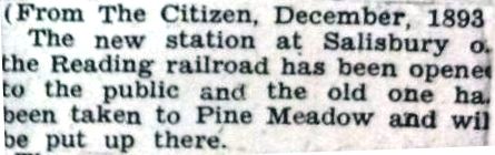
Four days after the first station burned, an article in the Courant said: "Salisbury's New Station. The railroad station at Salisbury was burned down several days ago. A passenger coach which has been fitted up with telegraph wires, is doing duty for a station until one can be built." The Coonecticut Western News, published in this very village, said nothing about the use of a coach, but did speak of a replacement structure built within seven days of the fire. An entry in a PR&NE record book at the Baker Library shows an expenditure of $86.64, perhaps not the total cost, on a page dated 2/28/1893 under "New Depots -- New Station Salisbury." The clipping at left says that, after the permanent replacement for SALISBURY1 opened in December, 1893, the "old one" was moved and so we have designated it as PINE MEADOW4. The relocated structure can only be the "small building... erected for present use" that was put up in January after the fire that took SALISBURY1. While we sometimes gloss over temporary depots of short duration, the fact that this one was in service for nearly a year here and then went on for use at another stop necessitates an exception. We have no photograph of this inexpensive, interim station. [REFS: B230.90; HC/01/16/1893/06; CWN/01/19/1893/02; WC/12/00/1893/00][rev061313, 050123]
Four days after the first station burned, an article in the Courant said: "Salisbury's New Station. The railroad station at Salisbury was burned down several days ago. A passenger coach which has been fitted up with telegraph wires, is doing duty for a station until one can be built." The Coonecticut Western News, published in this very village, said nothing about the use of a coach, but did speak of a replacement structure built within seven days of the fire. An entry in a PR&NE record book at the Baker Library shows an expenditure of $86.64, perhaps not the total cost, on a page dated 2/28/1893 under "New Depots -- New Station Salisbury." The clipping at left says that, after the permanent replacement for SALISBURY1 opened in December, 1893, the "old one" was moved and so we have designated it as PINE MEADOW4. The relocated structure can only be the "small building... erected for present use" that was put up in January after the fire that took SALISBURY1. While we sometimes gloss over temporary depots of short duration, the fact that this one was in service for nearly a year here and then went on for use at another stop necessitates an exception. We have no photograph of this inexpensive, interim station. [REFS: B230.90; HC/01/16/1893/06; CWN/01/19/1893/02; WC/12/00/1893/00][rev061313, 050123]
|
|

|
|
|
|
Lee Beaujon Collection
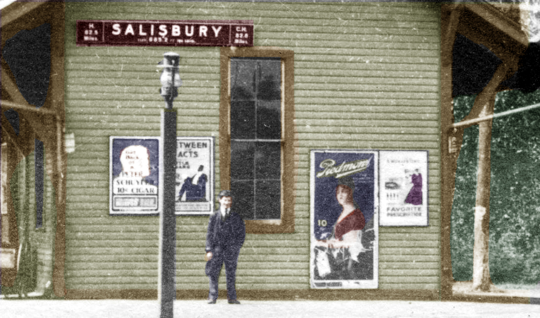
SALISBURY3 [PR&NE, 1893]
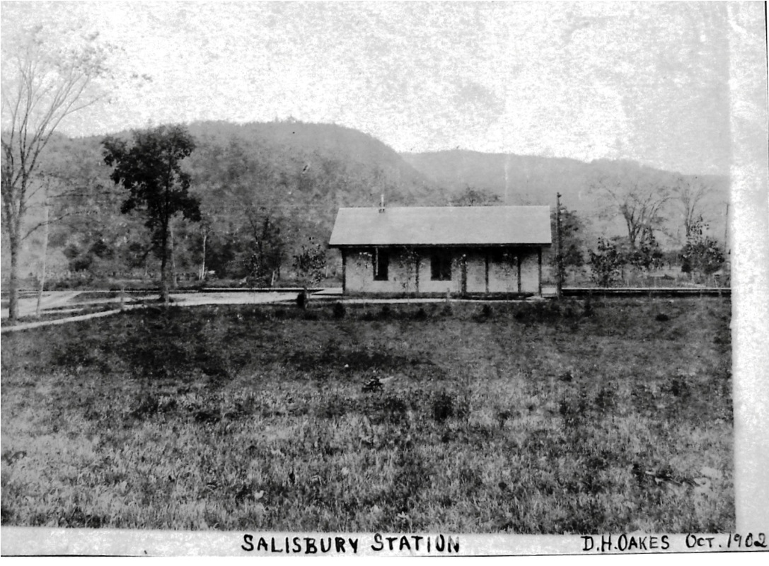
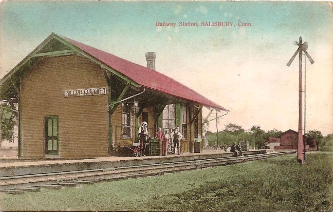
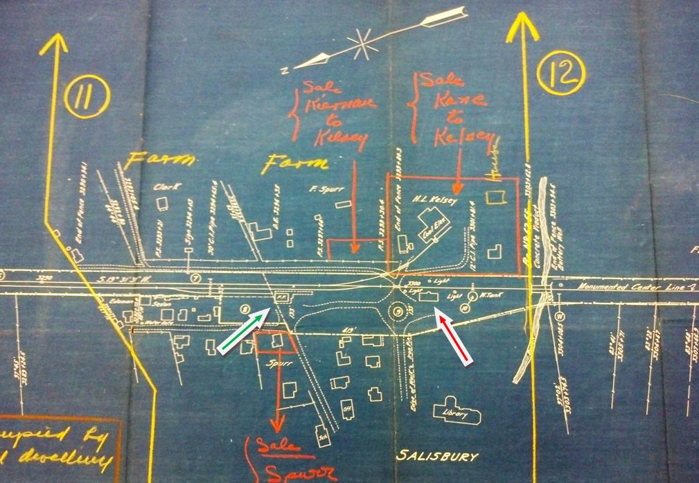
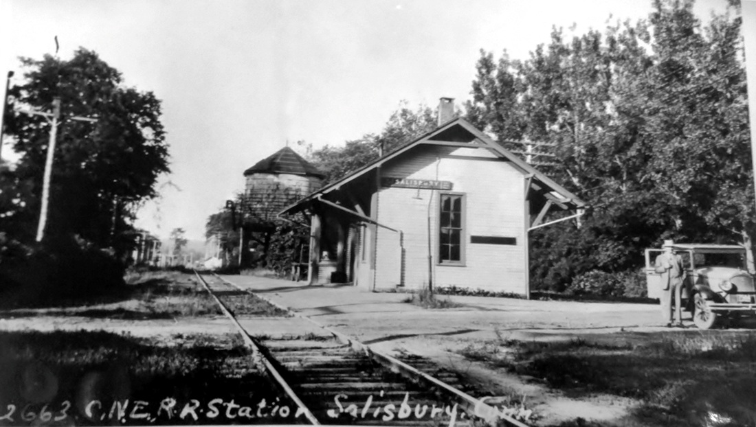
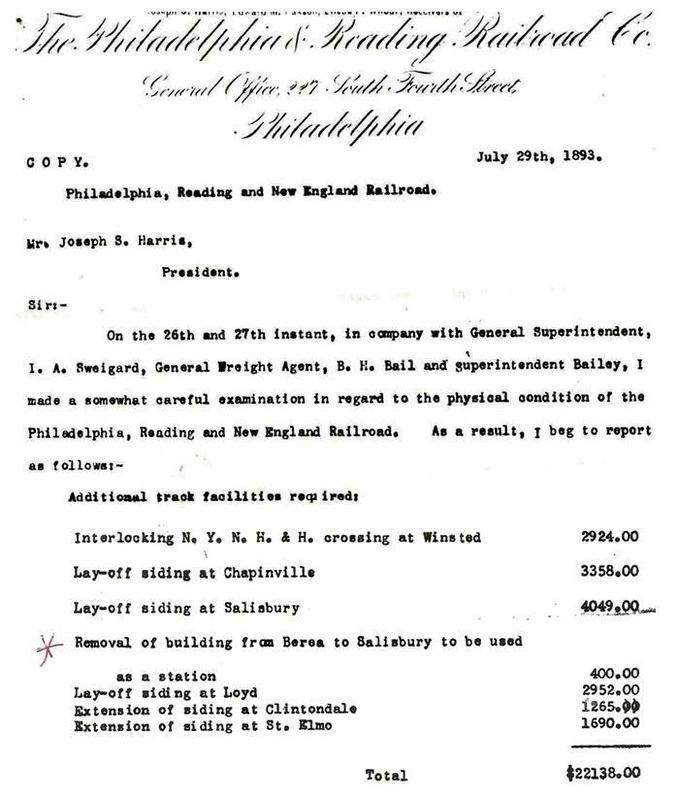
The origin of the permanent replacement station here has been a source of debate for some time. The reminiscences of 48-year railroad veteran Edward Ashman, as recounted by his son Robert, say that the "Salisbury station had burned down years ago and the station which today is the house standing east of the Scoville Library was dismantled at St. Elmo, N.Y., and brought on flat cars to Salisbury and rebuilt. St. Elmo was just east of Maybrook." Lee Beaujon recalls a similar tale told by railroaders he worked with at Canaan but with the station coming from Berea, NY. Lee offers the 7/29/1893 letter at [7] which, first of all, seems to validate the otherwise undocumented event and, secondly, attributes the point of origin as Berea. We have patched together the relevant parts of the five-page letter showing the recommended "Removal of building from Berea to Salisbury to be used as a station," the $400 expense proposed as a cost-saving measure. The word 'building' is a bit of a rub because SALISBURY3 is indeed a purpose-built station that looks like the Maybrook-line depots at Highland, Lloyd, and Clintondale, all in NY, and we wonder whether the PR&NE decided that, instead of moving just a 'building,' they would be better off moving a real depot for the same money. It may be worthy of note that there still is a station at St. Elmo and there is none at Berea. The letter's July, 1893 date dovetails with a newspaper report in October, 1893 saying that "the work on the R.R. station (which has been so much needed) has already begun." This might seem to imply building a new one but, under the circumstances, may only indicate site preparation prior to the move. Surprisingly, no newspaper article about the long-distance transfer of a disassembled station, across the Poughkeepsie Bridge, no less -- a sight which undoubtedly would have caught the eye of many -- has yet been found. No mention also in the annual reports of the railroads or railroad commissioners of CT or NY. While new evidence may someday further clarify the events here, the movement of the Berea depot to Salisbury in October, 1893 is the scenario that makes the most sense. The shot at [1] was taken by D. Oakes, town druggist and amateur photographer, in October, 1902. The eastward-looking card image at [2] has a 1908 postmark. The c1910 view at [3] looks west and shows the water tank, the footings for which are still in the ground today. A colorized enlargement of this image is at [4]. The val map at [5] shows the freight station at our green arrow and SALISBURY3 at the red arrow. The shot at [6] is a June, 1930 Lewis H. Benton photo, his #2663, with fellow photographer Irving Drake standing by his automobile; note the newer water tank. On the 1938 SSRR list, this station is retired and up for disposal. SALISBURY3, turned 90 degrees and moved slightly back from the ROW, still stands today as a residence at the foot of Library St. The Scoville Library has a great local history collection and it has digitized long microfilm runs of the Connecticut Western News and the Lakeville Journal. Click here and look under 'How Can I...?.' Dioramas created by local modelers depicting the Lakeville and Salisbury portions of the CNE are housed in the library basement. [REFS: CWN/10/05/1893/02; HC/04/06/1903/02; A9,35; D47; R87: Berea; Historic Resource Inventory says St. Elmo][rev010518, 050123]
The origin of the permanent replacement station here has been a source of debate for some time. The reminiscences of 48-year railroad veteran Edward Ashman, as recounted by his son Robert, say that the "Salisbury station had burned down years ago and the station which today is the house standing east of the Scoville Library was dismantled at St. Elmo, N.Y., and brought on flat cars to Salisbury and rebuilt. St. Elmo was just east of Maybrook." Lee Beaujon recalls a similar tale told by railroaders he worked with at Canaan but with the station coming from Berea, NY. Lee offers the 7/29/1893 letter at [7] which, first of all, seems to validate the otherwise undocumented event and, secondly, attributes the point of origin as Berea. We have patched together the relevant parts of the five-page letter showing the recommended "Removal of building from Berea to Salisbury to be used as a station," the $400 expense proposed as a cost-saving measure. The word 'building' is a bit of a rub because SALISBURY3 is indeed a purpose-built station that looks like the Maybrook-line depots at Highland, Lloyd, and Clintondale, all in NY, and we wonder whether the PR&NE decided that, instead of moving just a 'building,' they would be better off moving a real depot for the same money. It may be worthy of note that there still is a station at St. Elmo and there is none at Berea. The letter's July, 1893 date dovetails with a newspaper report in October, 1893 saying that "the work on the R.R. station (which has been so much needed) has already begun." This might seem to imply building a new one but, under the circumstances, may only indicate site preparation prior to the move. Surprisingly, no newspaper article about the long-distance transfer of a disassembled station, across the Poughkeepsie Bridge, no less -- a sight which undoubtedly would have caught the eye of many -- has yet been found. No mention also in the annual reports of the railroads or railroad commissioners of CT or NY. While new evidence may someday further clarify the events here, the movement of the Berea depot to Salisbury in October, 1893 is the scenario that makes the most sense. The shot at [1] was taken by D. Oakes, town druggist and amateur photographer, in October, 1902. The eastward-looking card image at [2] has a 1908 postmark. The c1910 view at [3] looks west and shows the water tank, the footings for which are still in the ground today. A colorized enlargement of this image is at [4]. The val map at [5] shows the freight station at our green arrow and SALISBURY3 at the red arrow. The shot at [6] is a June, 1930 Lewis H. Benton photo, his #2663, with fellow photographer Irving Drake standing by his automobile; note the newer water tank. On the 1938 SSRR list, this station is retired and up for disposal. SALISBURY3, turned 90 degrees and moved slightly back from the ROW, still stands today as a residence at the foot of Library St. The Scoville Library has a great local history collection and it has digitized long microfilm runs of the Connecticut Western News and the Lakeville Journal. Click here and look under 'How Can I...?.' Dioramas created by local modelers depicting the Lakeville and Salisbury portions of the CNE are housed in the library basement. [REFS: CWN/10/05/1893/02; HC/04/06/1903/02; A9,35; D47; R87: Berea; Historic Resource Inventory says St. Elmo][rev010518, 050123]
Copyright NHRHTA
|

Archives & Special Collections, UConn
|
Copyright NHRHTA
|
TCS Collection
|
|
Max Miller Collection
|
 National Archives
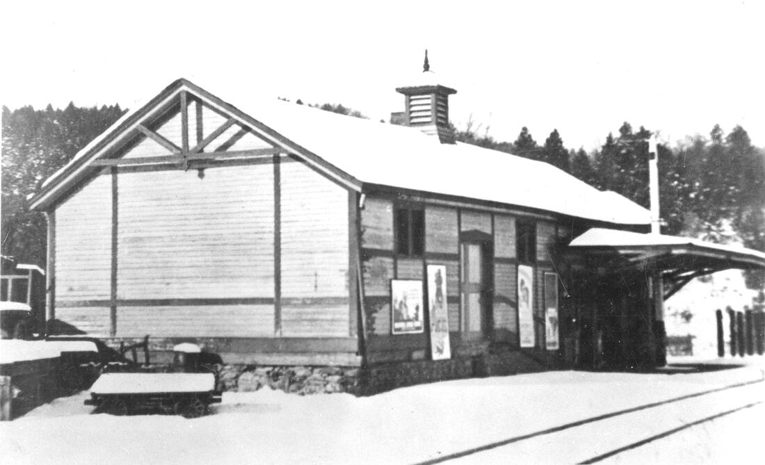
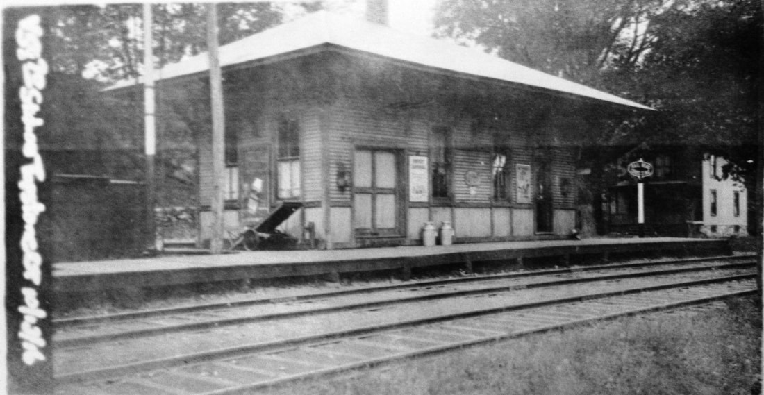
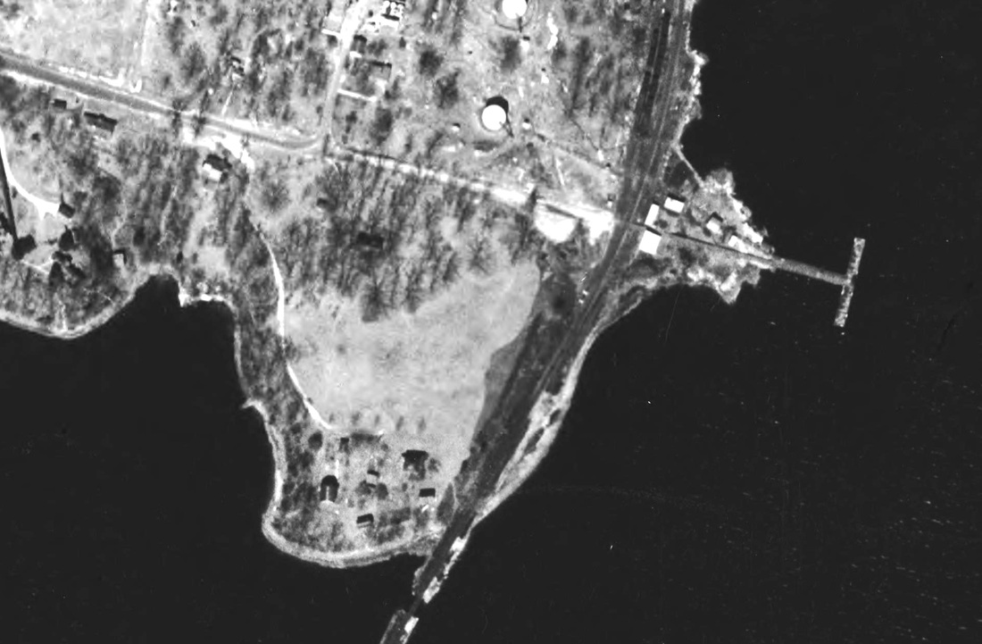
SANDY HOOK [NY&NE, 1881]
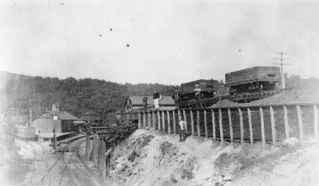
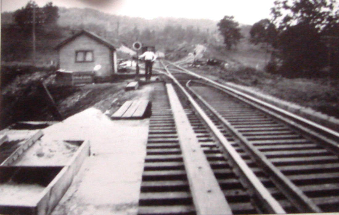
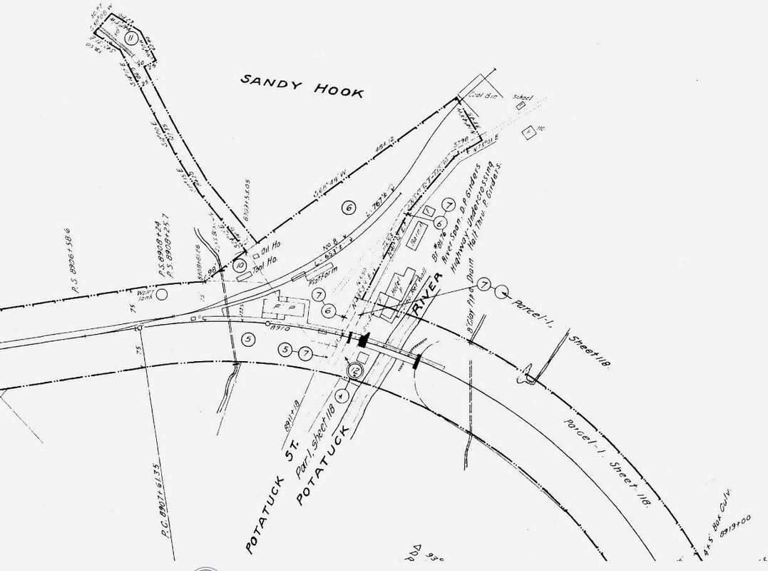
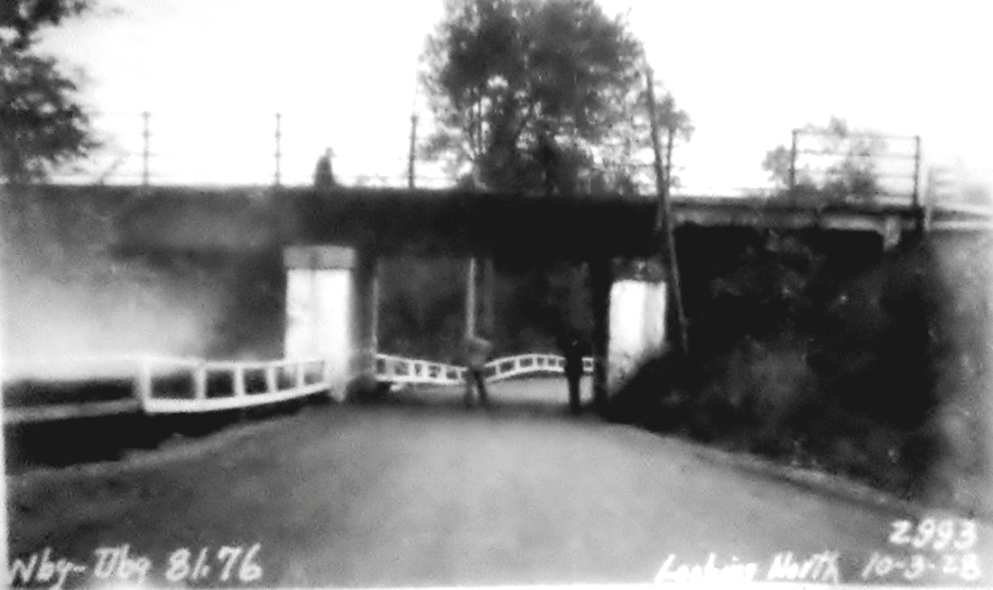
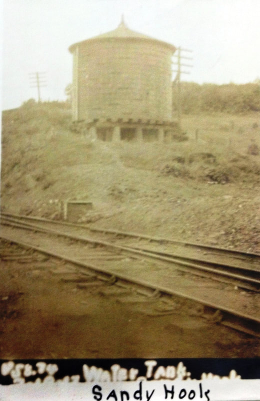
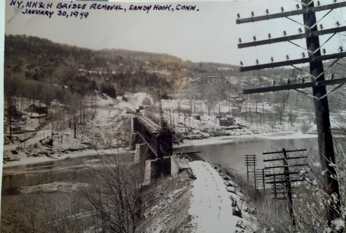
This section of Newtown is so named for the 'hook' and sandy beach at the confluence of the Housatonic and Pootatuck Rivers. The village has a fascinating history as a summer resort and as an industrial enclave using the waterpower of the latter river that runs along Glen Rd. In fact, this is said to be the first place where Charles Goodyear's vulcanization process was used at the 'rubber factory' here ca. 1839. Today called Rocky Glen Mill, the complex received an NRHP designation in 1982. Local businesses welcomed the coming of the NY&NE for proximity as well as economics, this station being much nearer than the downtown depot of the HRR and that road said in 1880 to be charging prices "... more than any other railroad in the country."(!) This building was under construction late in 1880 on the western extension of the NY&NE. The line was certified as safe by the railroad commissioners on 7/22/1881 and the first train ran from Hartford to Brewster, NY on 7/25/1881. Leman Oatman, the energetic Hartford contractor, is usually credited for this depot and similar ones but we read in the Newtown Bee that the contract for this one was awarded to John Halligan, "... who is a good builder and a very worthy man." This implies that the railroad had drawn up the architectural plan and the builder only followed the instructions. The tinning of the roof for fire protection was apparently a separate specialty for which Daniel Camp was chosen. The structure here was the large, combination-depot type, virtually identical to those at SOUTHBURY and SOUTHFORD. If finished like the latter, there were separate waiting rooms for men and women plus toilet facilities, with the interior oiled wood, the exterior green with red trim and the roof brown. The westward view at [1] looks toward the freight end of the station, with the operator's bay and passenger rooms framed by the overhang at the other end. The 1886 map at [2] shows the layout of the grounds. Our twin red arrows point to the mini-turntables on the elevated coal trestle which allowed the small dump cars to be oriented to the main line where they were tipped to fill the locomotive tenders below. Just beyond, the arrows point to the water tank and the track-side 'water crane.' The rare and unique photo [3] dovetails beautifully with the map. It looks like the guys are posing for the photographer, perhaps having just filled the dump car that stands at the ready. The white disk atop the water crane is a 'go' signal indicating that the crane is not fouling the track. The shot at [4] looks west from the edge of the Housatonic River bridge and shows a young man standing at the switch for the passing track. The rise of the coal siding is apparent at the right. Locomotives probably had to back out onto the bridge for a running start to shove the hopper cars up the steep incline. It must have been something to see! The 1915 ICC valuation map at [5] shows the coal siding gone. Likely with more freight going on the Maybrook Line, via Derby to Hartford and Devon to Cedar Hill, the old facilities were seen as unnecessary here. The 10/23/1928 PUC shot at [6] shows the commissioners using the storied 'story stick' to measure the clearance under the Glen Rd. bridge immediately west of the station. These annual inspections of grade crossings and bridge heights were done in the interest of public safety. This was actually a double bridge that also spanned the adjacent Pootatuck River at left. The ICC image at [7] shows the massive water tank. If time travel is ever to be possible, this would be high on our list of places to visit! [REFS: NBE/01/21/1880/04; NBE/11/17/1880/03; NBE/12/08/1880/03; HC/07/23/1881/02; CRC31.1884.19: coaling station; NBE/12/25/1908/03: new water tank; National Register of Historic Places, 6/8/1982; D140][rev123017, 050222, 022623]
This section of Newtown is so named for the 'hook' and sandy beach at the confluence of the Housatonic and Pootatuck Rivers. The village has a fascinating history as a summer resort and as an industrial enclave using the waterpower of the latter river that runs along Glen Rd. In fact, this is said to be the first place where Charles Goodyear's vulcanization process was used at the 'rubber factory' here ca. 1839. Today called Rocky Glen Mill, the complex received an NRHP designation in 1982. Local businesses welcomed the coming of the NY&NE for proximity as well as economics, this station being much nearer than the downtown depot of the HRR and that road said in 1880 to be charging prices "... more than any other railroad in the country."(!) This building was under construction late in 1880 on the western extension of the NY&NE. The line was certified as safe by the railroad commissioners on 7/22/1881 and the first train ran from Hartford to Brewster, NY on 7/25/1881. Leman Oatman, the energetic Hartford contractor, is usually credited for this depot and similar ones but we read in the Newtown Bee that the contract for this one was awarded to John Halligan, "... who is a good builder and a very worthy man." This implies that the railroad had drawn up the architectural plan and the builder only followed the instructions. The tinning of the roof for fire protection was apparently a separate specialty for which Daniel Camp was chosen. The structure here was the large, combination-depot type, virtually identical to those at SOUTHBURY and SOUTHFORD. If finished like the latter, there were separate waiting rooms for men and women plus toilet facilities, with the interior oiled wood, the exterior green with red trim and the roof brown. The westward view at [1] looks toward the freight end of the station, with the operator's bay and passenger rooms framed by the overhang at the other end. The 1886 map at [2] shows the layout of the grounds. Our twin red arrows point to the mini-turntables on the elevated coal trestle which allowed the small dump cars to be oriented to the main line where they were tipped to fill the locomotive tenders below. Just beyond, the arrows point to the water tank and the track-side 'water crane.' The rare and unique photo [3] dovetails beautifully with the map. It looks like the guys are posing for the photographer, perhaps having just filled the dump car that stands at the ready. The white disk atop the water crane is a 'go' signal indicating that the crane is not fouling the track. The shot at [4] looks west from the edge of the Housatonic River bridge and shows a young man standing at the switch for the passing track. The rise of the coal siding is apparent at the right. Locomotives probably had to back out onto the bridge for a running start to shove the hopper cars up the steep incline. It must have been something to see! The 1915 ICC valuation map at [5] shows the coal siding gone. Likely with more freight going on the Maybrook Line, via Derby to Hartford and Devon to Cedar Hill, the old facilities were seen as unnecessary here. The 10/23/1928 PUC shot at [6] shows the commissioners using the storied 'story stick' to measure the clearance under the Glen Rd. bridge immediately west of the station. These annual inspections of grade crossings and bridge heights were done in the interest of public safety. This was actually a double bridge that also spanned the adjacent Pootatuck River at left. The ICC image at [7] shows the massive water tank. If time travel is ever to be possible, this would be high on our list of places to visit! [REFS: NBE/01/21/1880/04; NBE/11/17/1880/03; NBE/12/08/1880/03; HC/07/23/1881/02; CRC31.1884.19: coaling station; NBE/12/25/1908/03: new water tank; National Register of Historic Places, 6/8/1982; D140][rev123017, 050222, 022623]
|
Newtown Bee Archive
|

TylerCityStation Collection
|
Phil Wooding Collection
|

TylerCityStation Collection
|
TylerCityStation Collection
|
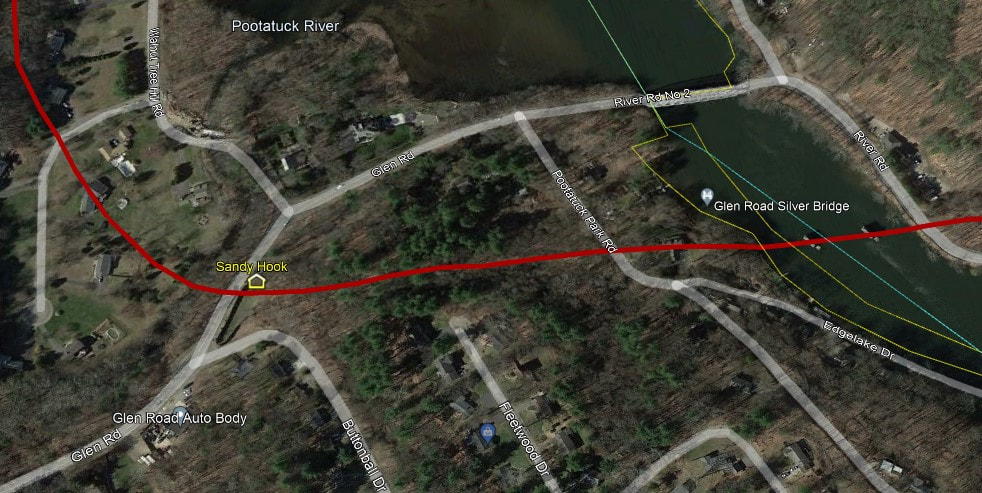
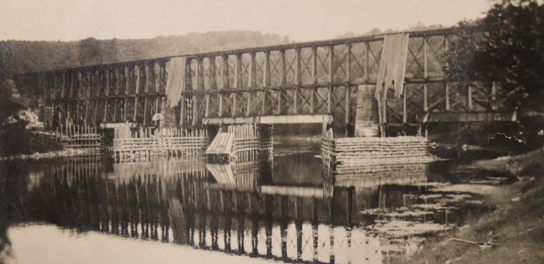
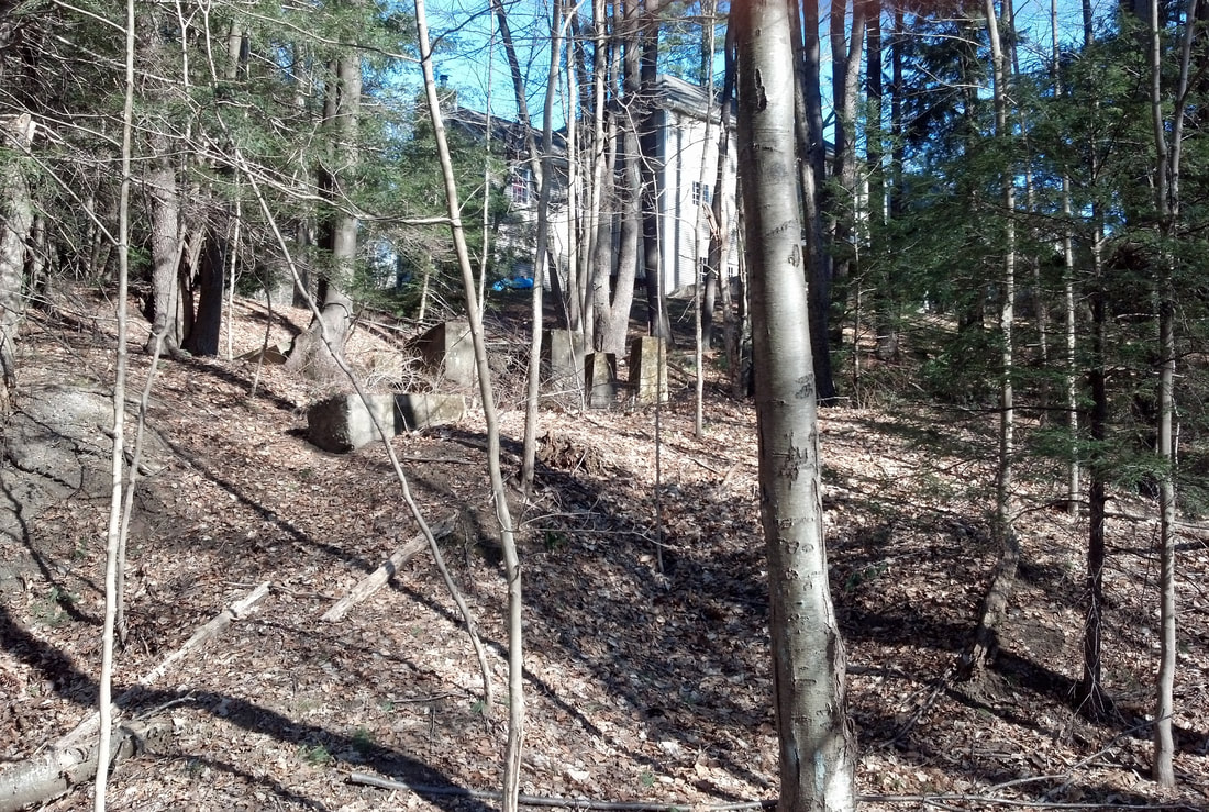
The Housatonic River bridge just east of this station was a marvel and must have been a thrill to ride over. This being the lowest elevation on the line to Waterbury, it required a high bridge 70 feet above the water below to keep the grade level constant. A helper engine was stationed here to push trains up the heavy grade eastward to TOWANTIC. Late in 1880 we read in the Bee that the "... new railroad bridge of the N.Y. & N.E. railroad, across the Housatonic River, is nearing completion. The top of the bridge is all covered and tinned, and they are now covering the sides. The stone cut just this side of the river is nearly finished, and soon the laying of track can be continued." The 'tin bridges' were more protected but they were still vulnerable to "a hot cinder," the presumed cause of "a spectacular fire" at about 10:45 a.m. on 11/19/1905 after a freight train had passed an hour earlier. The Bee reported that the blaze quickly consumed the wooden bridge "like shavings." The article goes on to say that the bridge was 25 years old, of the "... old deck variety, the rails being at the top with a box framework below..." and just 468 feet long. We interpret the 'just' as a compliment to its length! In the immediate aftermath of the fire passengers and freight were transferred around the break; a number of articles talk of delays caused by the bridge outage and increased traffic via Derby and on the CNE. No actual photo of this first bridge has yet surfaced, but the Fair Haven, CT photo of the Q Bridge at [1] shows the type of construction. At [2] we see the impressive trestle for the temporary bridge, 200 men at work on 11/21/1905, and expected to be finished in three weeks. The shot at [3] shows an eastbound train crossing the permanent bridge, begun on 10/01/1906 and completed on 1/19/1907. The dramatic aerial shot at [4], possibly taken by rail historian Col. Chet B. McCoid, shows the bridge being dismantled on 1/30/1949 after the ICC allowed the line from Hawleyville to Southbury to be abandoned. Passenger service thereafter was provided by both gas rail car and NETCO coach running from Danbury to Waterbury in 1931, by 1932 coach only. The aforementioned cut west of the river, as seen in [5], and the stone supports for the water tank at [6] were both evident on 4/6/2018 when John Roy and I visited. The Track 11 Google Earth map snippet at [7] shows the location of the former station grounds and the piers of the Housatonic River bridge east of the depot. Those monuments stand in silent testimony to the engineering challenges that made east-west railroads in Connecticut a heavy lift, cutting through solid rock and filling deep valleys. Of course, they also remind us of the passage of time in which much of that accomplishment has been obliterated. Many thanks to the folks at the Newtown Bee for their assistance. Founded in the 1870s, this paper has endowed us with a unique historical record through its coverage of Fairfield County far and wide. Best wishes for the future! [REFS: NBE/01/21/1880/04; NBE/10/27/1880/04; HC/11/21/1905/12; NHJC/11/23/1905/09; NBE/11/24/1905/05,09; HC/11/28/1905/12; NBE/10/05/1906/04; NBE/01/18/1907/10; NHAR36.1907.7; HC/12/11/1931/08: stop referred to as Berkshire; 1932 0200 Form 200 TT says refer to NETCo][rev050222, 061622]

SANFORD1 [D&N, 1852]
This was an original D&N flag stop in the town of Redding, appearing on an 1853TT and with the location shown on the 18656FC map. The station was hit by the up freight on 8/11/1891 "going at a high rate of speed" through an open switch and it "completely demolished" the depot. The engine only received minor damage but freight cars were wrecked and one blocked main line traffic for two hours. We have not yet found a picture of this station. [REFS: DN/03/28/1883/00box; NHER/08/11/1891/01; P17; SL17.2.12][rev050123]
This was an original D&N flag stop in the town of Redding, appearing on an 1853TT and with the location shown on the 18656FC map. The station was hit by the up freight on 8/11/1891 "going at a high rate of speed" through an open switch and it "completely demolished" the depot. The engine only received minor damage but freight cars were wrecked and one blocked main line traffic for two hours. We have not yet found a picture of this station. [REFS: DN/03/28/1883/00box; NHER/08/11/1891/01; P17; SL17.2.12][rev050123]
National Archives
|
Max Miller Collection
|

|

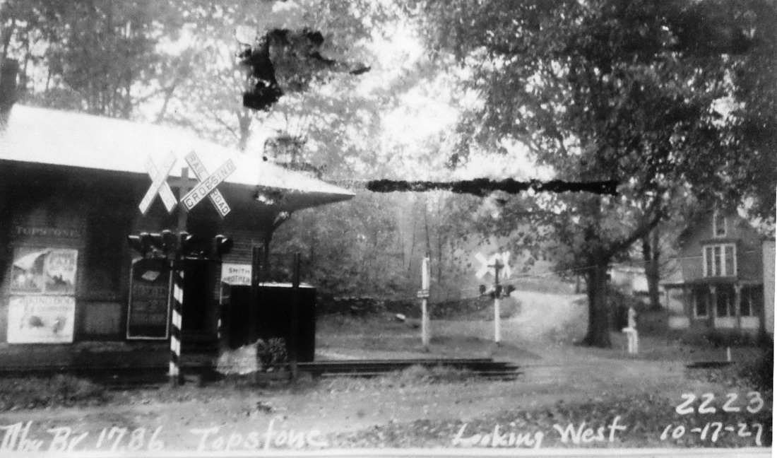
SANFORD2 [HRR, 1892]
The ICC valuation photo at [1] is dated 10/13/1916. The PUC shot at [3] was taken on 10/17/1927 and looks west. The 1915 ICC valuation map at [4] shows the station, highlighted in yellow, on the west side of the D&N main. The name apparently had already been changed to TOPSTONE by that time, we think between 1907 and 1908. A Bee article of the latter year uses the new name. The later-day shot at [3] shows the station boarded up. The 1938 SSRR list shows TOPSTONE as sold for $50.00 and removed in April of that year. [REFS: HC/06/09/1892/02; NHER/06/09/1892/04; LWTTrev7/8/1907: Sanfords; NBE/12/25/1908/14; RAM08][rev010518, 050123]
The ICC valuation photo at [1] is dated 10/13/1916. The PUC shot at [3] was taken on 10/17/1927 and looks west. The 1915 ICC valuation map at [4] shows the station, highlighted in yellow, on the west side of the D&N main. The name apparently had already been changed to TOPSTONE by that time, we think between 1907 and 1908. A Bee article of the latter year uses the new name. The later-day shot at [3] shows the station boarded up. The 1938 SSRR list shows TOPSTONE as sold for $50.00 and removed in April of that year. [REFS: HC/06/09/1892/02; NHER/06/09/1892/04; LWTTrev7/8/1907: Sanfords; NBE/12/25/1908/14; RAM08][rev010518, 050123]
SAUGATUCK [> WESTPORT]
SAYBROOK1 [NH&NL, 1852]
This stop in the town of Old Saybrook was established with the opening of the NH&NL in 1852. The location is seen on the 1859MC map. We have not yet found a photograph of this depot.
This stop in the town of Old Saybrook was established with the opening of the NH&NL in 1852. The location is seen on the 1859MC map. We have not yet found a photograph of this depot.
SAYBROOK2 [CW, 1871]
This was a small shed that the CV used for a station here on opening in 1871. It may have burned and in some ways prompted the building of a union station with the Shore Line in 1873.
This was a small shed that the CV used for a station here on opening in 1871. It may have burned and in some ways prompted the building of a union station with the Shore Line in 1873.

|
|
|

|
|
|
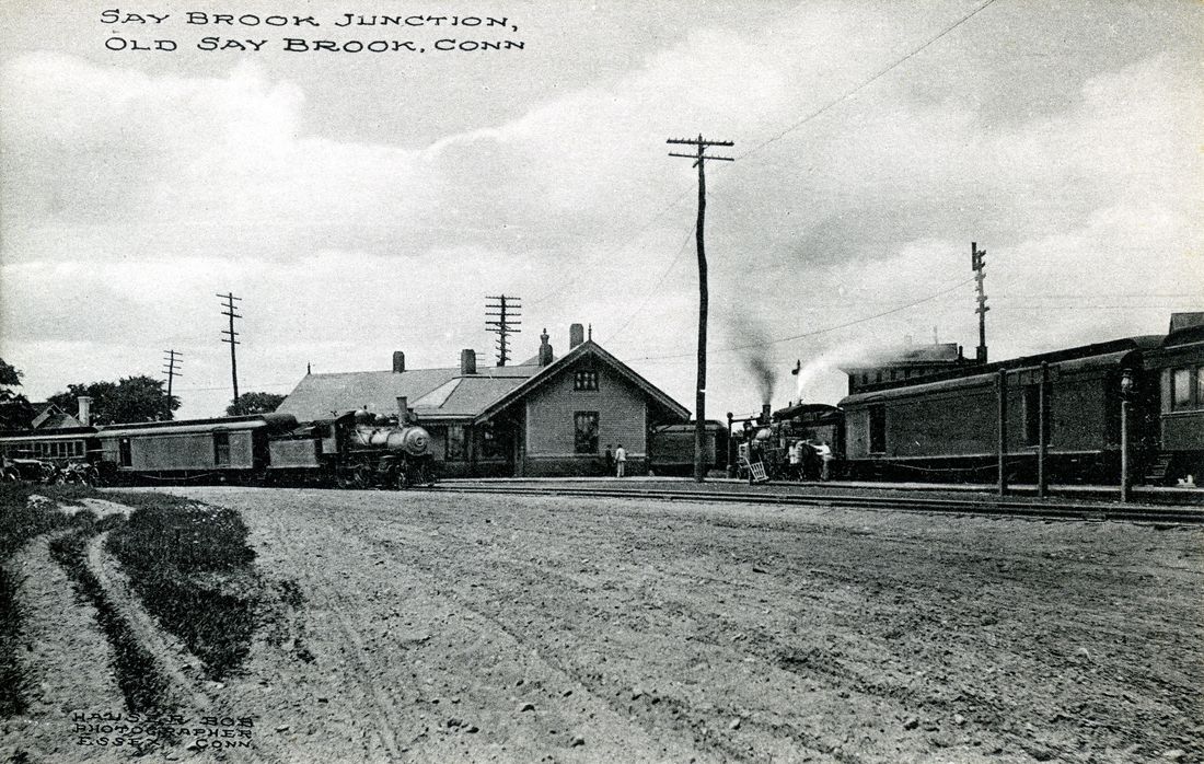
SAYBROOK3 [NYNH&H, 1873]
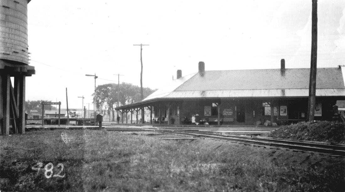
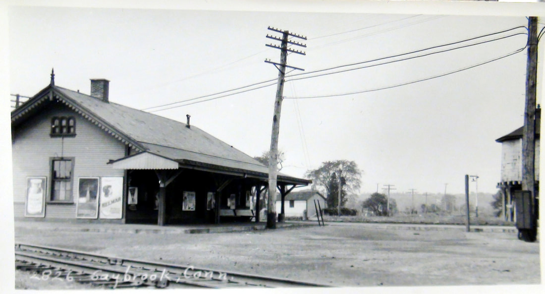
This stop was known as SAYBROOK JUNCTION after the Connecticut Valley RR opened in 1871 and as OLD SAYBROOK after the diamonds and tracks to SAYBROOK POINT were removed in 1922. The newspaper said in 1872 that SAYBROOK3 was to be built where SAYBROOK2 stood and it was to be similar to STRATFORD1. Minus the gable, it was, though this depot was wedge-shaped with a wing to serve each road as a union station. It was built in the southwest quadrant of the junction with the CV. An early 1873 Palladium article gives the opening date as 2/17/1873 and the railroad commissioners corroborate the year in their 1884 annual report. An 1883 Register article credits William P. Dickerman as the builder. In 2022, the station is still serving Amtrak, Shore Line East, and also the reborn Valley RR when it meets main line trains. New high-level platforms debuted on 11/1/2002. The view at [1] looks north with the passenger station at center, the brick-enclosed water tank in the northwest quadrant of the junction. The SS-102 tower and the 1873 Shore Line freight house are in the southeast quadrant. The train is passing the water tank headed east in the shot at [2]. Richard Fleischer notes interesting details that the Courant gave in 1874 about the watering operation here, claiming that the interior wooden tank held 23,230 gallons of water and cost as much as SAYBROOK3 plus the freight houses for both railroads combined. The view at [3] shows trains heading north to Essex and to Fenwick on the quadrant track. The 1915 ICC valuation map at [4] shows the layout of the junction. Lewis H. Benton took the photo [5], his #982, in 1917 probably on 8/23. The view looks south, with the Shore Line Electric Rwy bridge over the track to FENWICK in the distance. Note the new water tank in the northeast quadrant. Benton was back in 1929 to take his #2826, the northward-looking shot at [6]. By this time, the line to FENWICK had been abandoned and the diamonds were gone. As a result, the southwest quadrant wye track seen in [3] has been connected instead to the southeast quadrant track to serve the freight house, a change that preminent CV historian Max Miller thinks likely to have occurred in 1925. [REFS: HDC/09/24/1872/04; MDC/10/16/1872/02; NHDP/02/01/1873/04; NHDP/02/17/1873/04; CC/01/03/1874/04; HDC/09/03/1874/04; CRC21.1874.19; NHER/11/21/1883/01; R81][rev102017, 050123]
This stop was known as SAYBROOK JUNCTION after the Connecticut Valley RR opened in 1871 and as OLD SAYBROOK after the diamonds and tracks to SAYBROOK POINT were removed in 1922. The newspaper said in 1872 that SAYBROOK3 was to be built where SAYBROOK2 stood and it was to be similar to STRATFORD1. Minus the gable, it was, though this depot was wedge-shaped with a wing to serve each road as a union station. It was built in the southwest quadrant of the junction with the CV. An early 1873 Palladium article gives the opening date as 2/17/1873 and the railroad commissioners corroborate the year in their 1884 annual report. An 1883 Register article credits William P. Dickerman as the builder. In 2022, the station is still serving Amtrak, Shore Line East, and also the reborn Valley RR when it meets main line trains. New high-level platforms debuted on 11/1/2002. The view at [1] looks north with the passenger station at center, the brick-enclosed water tank in the northwest quadrant of the junction. The SS-102 tower and the 1873 Shore Line freight house are in the southeast quadrant. The train is passing the water tank headed east in the shot at [2]. Richard Fleischer notes interesting details that the Courant gave in 1874 about the watering operation here, claiming that the interior wooden tank held 23,230 gallons of water and cost as much as SAYBROOK3 plus the freight houses for both railroads combined. The view at [3] shows trains heading north to Essex and to Fenwick on the quadrant track. The 1915 ICC valuation map at [4] shows the layout of the junction. Lewis H. Benton took the photo [5], his #982, in 1917 probably on 8/23. The view looks south, with the Shore Line Electric Rwy bridge over the track to FENWICK in the distance. Note the new water tank in the northeast quadrant. Benton was back in 1929 to take his #2826, the northward-looking shot at [6]. By this time, the line to FENWICK had been abandoned and the diamonds were gone. As a result, the southwest quadrant wye track seen in [3] has been connected instead to the southeast quadrant track to serve the freight house, a change that preminent CV historian Max Miller thinks likely to have occurred in 1925. [REFS: HDC/09/24/1872/04; MDC/10/16/1872/02; NHDP/02/01/1873/04; NHDP/02/17/1873/04; CC/01/03/1874/04; HDC/09/03/1874/04; CRC21.1874.19; NHER/11/21/1883/01; R81][rev102017, 050123]

|
|

|

|
|
|
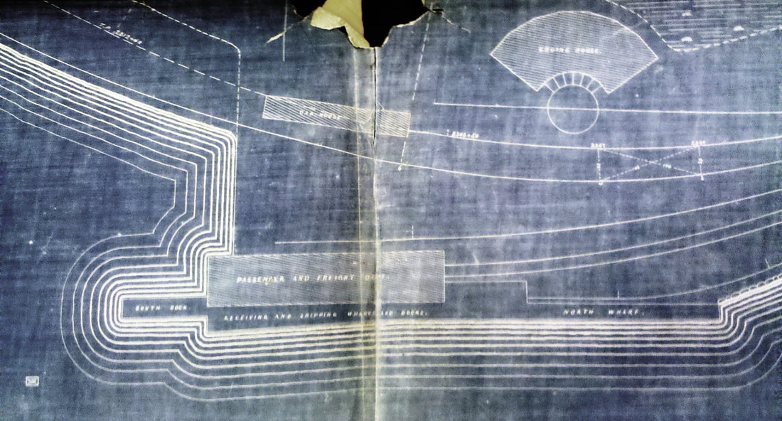
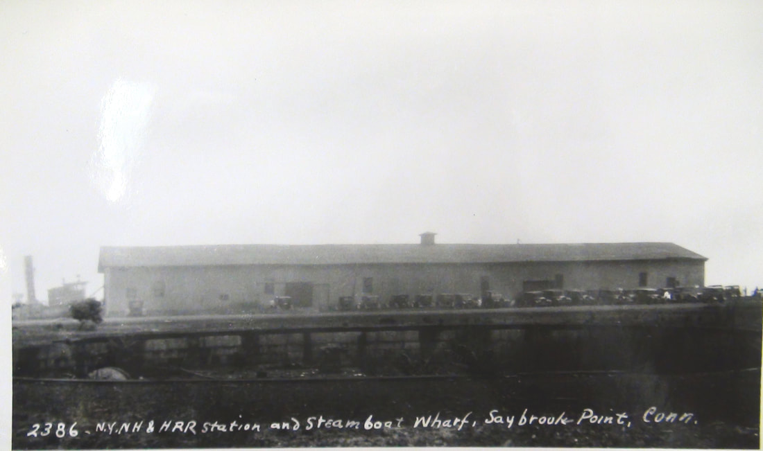
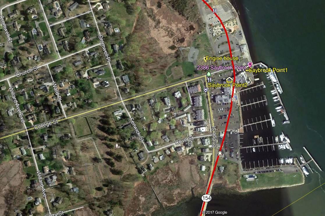
SAYBROOK POINT1 [CV, 1872]
The poor ICC valuation photo at [1] is dated 8/5/1916. The passenger station which was shared by steamboats was located at the water's edge, as seen in the 1872-1873 map at [2]. The postcard at [3] was mailed in 1914. We think we have seen the explanation of the occasion for which the band was marching at [4] but it escapes us just now. The building was damaged more than once by trains running into it but not stopping!. The first time was in 1872 when five freight cars on a flying switch kept going and pushed a parked passenger car completely through the station's sitting room so that the end of the car hung out over the water. The differences in newspaper reporting are interesting. The Courant said this was a "slight accident" and $500 would cover the damages. The Middletown Daily Constitution, closer to the scene and probably more reliable, said everything in the room was pushed into the water, the depot was "seriously injured," and that repairs would cost $2,000. Fortunately, no one was hurt. Another incident in July, 1916 caused the FENWICK depot, decommissioned since 1916, to be moved to do the honors here. The Lewis H. Benton shot #2386 at [5] was taken in June, 1929, according to our date chronology of his photos but interestingly he does not say it was the old or former station. Steamboats were still docking here but trackage had been removed in 1922. Also curious that he has no shot of the then-also-closed old FENWICK/SAYBROOK POINT2 depot across the street. The snippet at [6] is from our Track 11 Google Earth map and shows the location of all the facilties here. [REFS: HDC/08/25/1871/02; MDC/10/09/1872/02; HDC/10/10/1872/02; HWT/06/19/1899/10; HC/09/08/1916/07][rev101717, 050123]
The poor ICC valuation photo at [1] is dated 8/5/1916. The passenger station which was shared by steamboats was located at the water's edge, as seen in the 1872-1873 map at [2]. The postcard at [3] was mailed in 1914. We think we have seen the explanation of the occasion for which the band was marching at [4] but it escapes us just now. The building was damaged more than once by trains running into it but not stopping!. The first time was in 1872 when five freight cars on a flying switch kept going and pushed a parked passenger car completely through the station's sitting room so that the end of the car hung out over the water. The differences in newspaper reporting are interesting. The Courant said this was a "slight accident" and $500 would cover the damages. The Middletown Daily Constitution, closer to the scene and probably more reliable, said everything in the room was pushed into the water, the depot was "seriously injured," and that repairs would cost $2,000. Fortunately, no one was hurt. Another incident in July, 1916 caused the FENWICK depot, decommissioned since 1916, to be moved to do the honors here. The Lewis H. Benton shot #2386 at [5] was taken in June, 1929, according to our date chronology of his photos but interestingly he does not say it was the old or former station. Steamboats were still docking here but trackage had been removed in 1922. Also curious that he has no shot of the then-also-closed old FENWICK/SAYBROOK POINT2 depot across the street. The snippet at [6] is from our Track 11 Google Earth map and shows the location of all the facilties here. [REFS: HDC/08/25/1871/02; MDC/10/09/1872/02; HDC/10/10/1872/02; HWT/06/19/1899/10; HC/09/08/1916/07][rev101717, 050123]
|

|

|
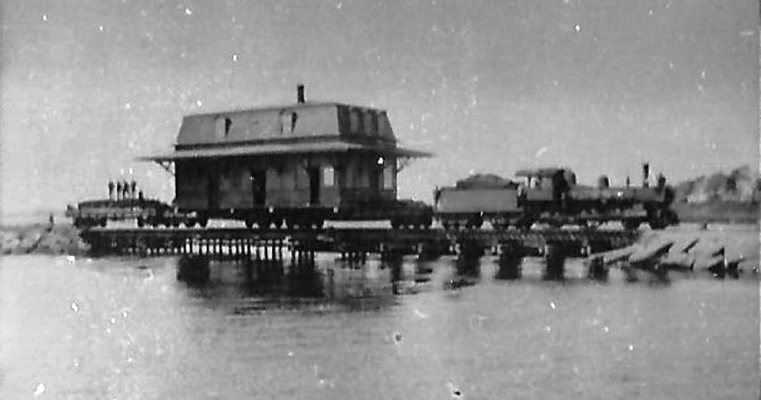
SAYBROOK POINT2 [NYNH&H, 1916]
The FENWICK station building was moved here on 9/26/1916 to become SAYBROOK POINT2. It was already in disuse at the CV line terminus before trackage from here south was first abandoned in 1917. The memorable transfer is pictured at [1] with the depot being pulled up the causeway to its new location. It was officially designated as the new station here on 11/24/1916 according to Max Miller, the old wharf depot was used thereafter only for steamboats. SAYBROOK POIONT2 is seen in the left distance in the shot at [2]. The 1915 val map at [3] still shows SAYBROOK POINT1 as the station at the yellow highlighting and our red arrow indicates where the old FENWICK station was placed. Track was further cut back to SAYBROOK in 1922 ending all railroad service here but the wharf continued to see boats until 1931. The FENWICK/SAYBROOK POINT2 structure served thereafter as a refreshment stand and/or as part of a casino per Max Miller until it was torn down, possibly in 1956. [REFS: HC/11/28/1916/08; V48][rev1020117, 050123]
The FENWICK station building was moved here on 9/26/1916 to become SAYBROOK POINT2. It was already in disuse at the CV line terminus before trackage from here south was first abandoned in 1917. The memorable transfer is pictured at [1] with the depot being pulled up the causeway to its new location. It was officially designated as the new station here on 11/24/1916 according to Max Miller, the old wharf depot was used thereafter only for steamboats. SAYBROOK POIONT2 is seen in the left distance in the shot at [2]. The 1915 val map at [3] still shows SAYBROOK POINT1 as the station at the yellow highlighting and our red arrow indicates where the old FENWICK station was placed. Track was further cut back to SAYBROOK in 1922 ending all railroad service here but the wharf continued to see boats until 1931. The FENWICK/SAYBROOK POINT2 structure served thereafter as a refreshment stand and/or as part of a casino per Max Miller until it was torn down, possibly in 1956. [REFS: HC/11/28/1916/08; V48][rev1020117, 050123]
SCANTIC [> EAST WINDSOR]
SCITICO [> HAZARDVILLE]
SCITICO [> HAZARDVILLE]
|
|
|
SCOTCH CAP [CVT, c1930]
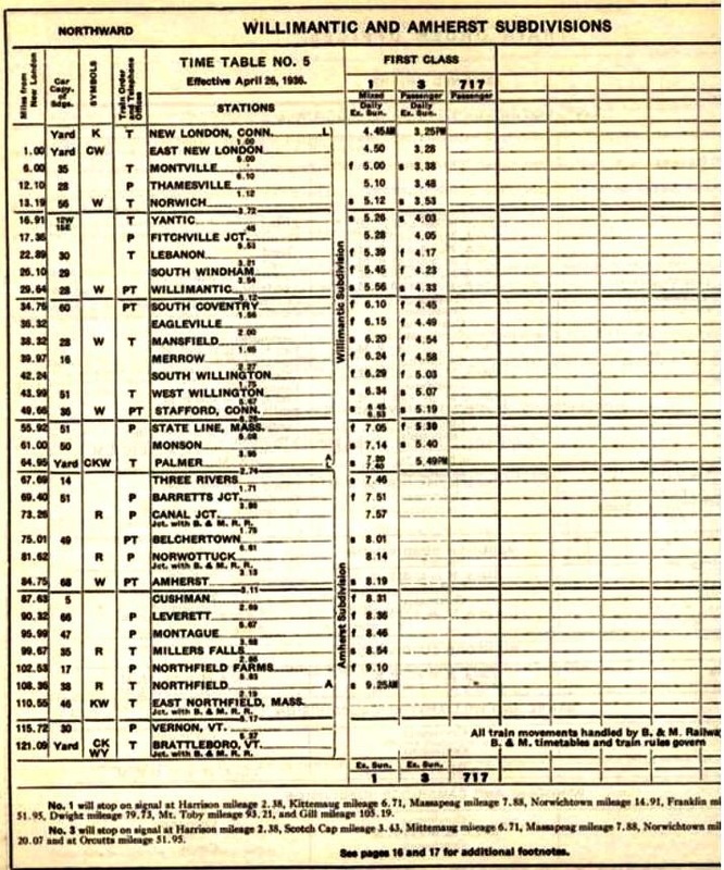
Our newspaper search for this locale in the town of Waterford yielded its first hit in 1862, ironically in a railroad context, when the last two of four cars on a northbound NLN passenger train derailed as a culvert "near Scotch Cap, about four miles north of the city [New London] became clogged and the heavy rain undermined the embankment." Only "a clump of trees and a huge rock" on the bank reportedly prevented the cars from toppling into the river. Apparently known well enough already as a place for picnics and recreational outings, it was deemed especially appropriate in one commentary for the gathering of the 26th Regiment, Connecticut Volunteers, because of the historic vistas of the Groton Monument and Fort Griswold. Unfortunately, the train failed to stop for the men going home to Norwich but, undeterred, they marched to the tune of Yankee Doodle and Hail to the Chief all the way to New London where they "spent an agreeable hour until the departure of the trains" from Union Station. Other articles mention rail service here as well in what must be considered a special, seasonal stop, long before it became official ca. 1930. The intriguing name may derive from the ancestral origins of the local population or the lampooning of President-elect Lincoln's reported donning of a tam o' shanter and Scottish garb as a security precaution on the way to his inauguration in 1861. This station does not appear on the 1926 official list at left but it shows up in the footnotes on ETT #5 (4/26/1936) as a flag stop 3.43 miles from New London. The 1934 aerial map at right shows a small trackside structure that might have been a passenger waiting shed. We note, inasmuch as WATERFORD no longer appears on the 1936 ETT, that it is likely that SCOTCH CAP, just across Smiths Cove, took its place for some reason. [REFS: NLDC/06/06/1862/02; NLD/08/10/1867/02; NLD/08/12/1869/02; NA/08/25/1869/03; NA/09/29/1869/03 NLD/09/18/1869/01; NC/08/16/1876/06; NLD/07/10/1904/07; RAM: no listings][rev091813, 050323]
Our newspaper search for this locale in the town of Waterford yielded its first hit in 1862, ironically in a railroad context, when the last two of four cars on a northbound NLN passenger train derailed as a culvert "near Scotch Cap, about four miles north of the city [New London] became clogged and the heavy rain undermined the embankment." Only "a clump of trees and a huge rock" on the bank reportedly prevented the cars from toppling into the river. Apparently known well enough already as a place for picnics and recreational outings, it was deemed especially appropriate in one commentary for the gathering of the 26th Regiment, Connecticut Volunteers, because of the historic vistas of the Groton Monument and Fort Griswold. Unfortunately, the train failed to stop for the men going home to Norwich but, undeterred, they marched to the tune of Yankee Doodle and Hail to the Chief all the way to New London where they "spent an agreeable hour until the departure of the trains" from Union Station. Other articles mention rail service here as well in what must be considered a special, seasonal stop, long before it became official ca. 1930. The intriguing name may derive from the ancestral origins of the local population or the lampooning of President-elect Lincoln's reported donning of a tam o' shanter and Scottish garb as a security precaution on the way to his inauguration in 1861. This station does not appear on the 1926 official list at left but it shows up in the footnotes on ETT #5 (4/26/1936) as a flag stop 3.43 miles from New London. The 1934 aerial map at right shows a small trackside structure that might have been a passenger waiting shed. We note, inasmuch as WATERFORD no longer appears on the 1936 ETT, that it is likely that SCOTCH CAP, just across Smiths Cove, took its place for some reason. [REFS: NLDC/06/06/1862/02; NLD/08/10/1867/02; NLD/08/12/1869/02; NA/08/25/1869/03; NA/09/29/1869/03 NLD/09/18/1869/01; NC/08/16/1876/06; NLD/07/10/1904/07; RAM: no listings][rev091813, 050323]
SCOTLAND/B [> NORTH BLOOMFIELD]
SCOTLAND/E [> BURNSIDE]
SCOTLAND/E [> BURNSIDE]
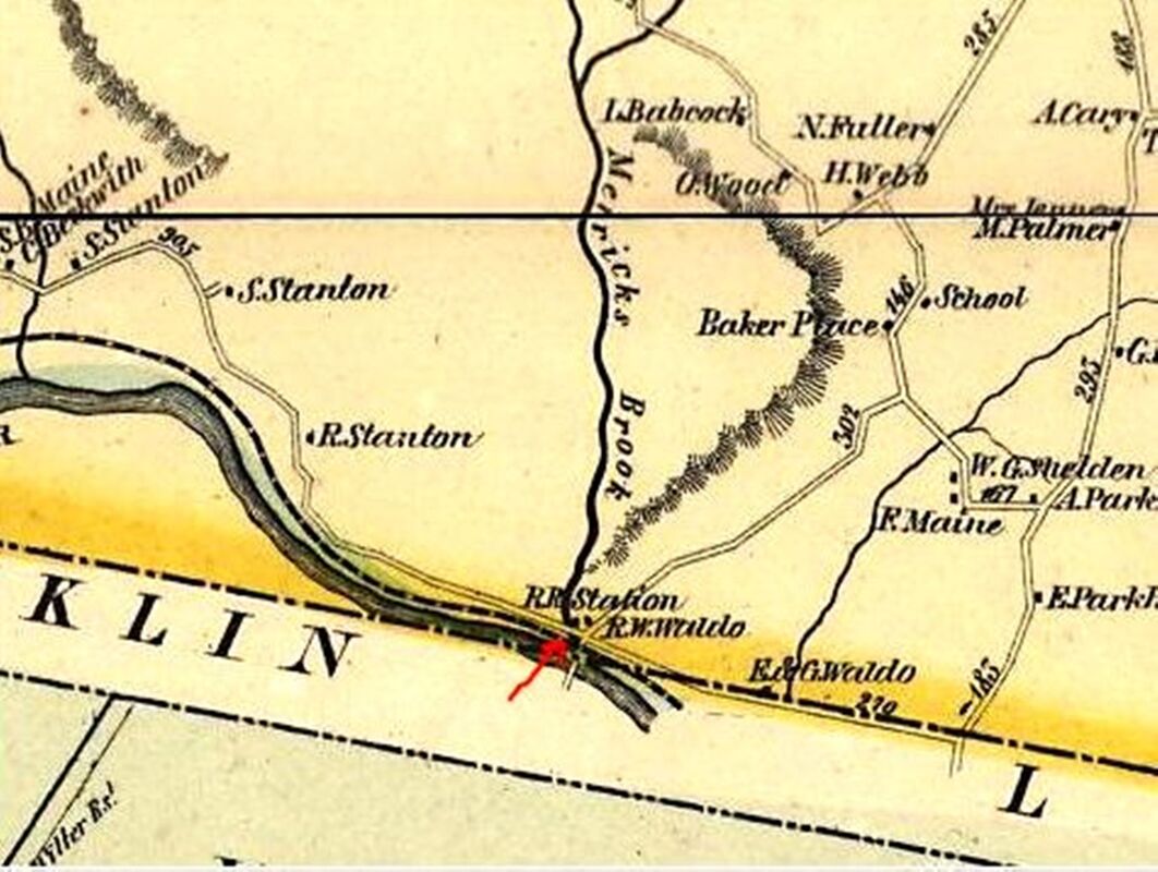
SCOTLAND1 [HP&F, 1854; opens as WALDO'S]
This HP&F stop was east of Willimantic in the town of Scotland and is seen on some timetables as WALDO'S. The 1856WC map shows the location, which was just over the Franklin town line. We do not have any picture of a station earlier than the one shown below. The town of Sprague was incorporated in 1861 and its border intersects Franklin's right at the former station site. We do see the surname Waldo on homes just east of the stop. [REFS: C131][rev 050323]
This HP&F stop was east of Willimantic in the town of Scotland and is seen on some timetables as WALDO'S. The 1856WC map shows the location, which was just over the Franklin town line. We do not have any picture of a station earlier than the one shown below. The town of Sprague was incorporated in 1861 and its border intersects Franklin's right at the former station site. We do see the surname Waldo on homes just east of the stop. [REFS: C131][rev 050323]

Dave Peters Collection
|

|

|
SCOTLAND2 [NYNH&H, 1899]
The railroad commissioners say in December, 1899 that a small new depot was erected here during the year and the 7/5/1916 val photo at left must be it. The coach seen beyond it is said to be in use as the passenger station and, together with the wooden building, formed a combination station. The temporary use of a coach has been seen elsewhere, often after a fire, but here it may be a means of avoiding the construction of a larger station to serve the increased business at this stop. The other two photos seem to show the building abandoned. The 1938 SSRR list has this station as retired and to be disposed of. [REFS: CRC47.1899.31][rev010518, 050323]
The railroad commissioners say in December, 1899 that a small new depot was erected here during the year and the 7/5/1916 val photo at left must be it. The coach seen beyond it is said to be in use as the passenger station and, together with the wooden building, formed a combination station. The temporary use of a coach has been seen elsewhere, often after a fire, but here it may be a means of avoiding the construction of a larger station to serve the increased business at this stop. The other two photos seem to show the building abandoned. The 1938 SSRR list has this station as retired and to be disposed of. [REFS: CRC47.1899.31][rev010518, 050323]
|
Orange Historical Society
|
|
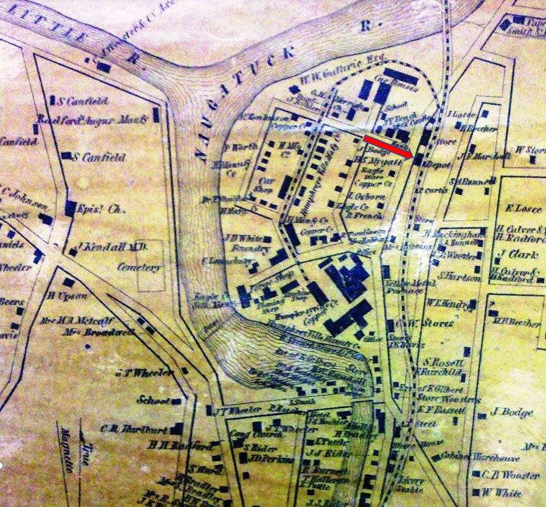
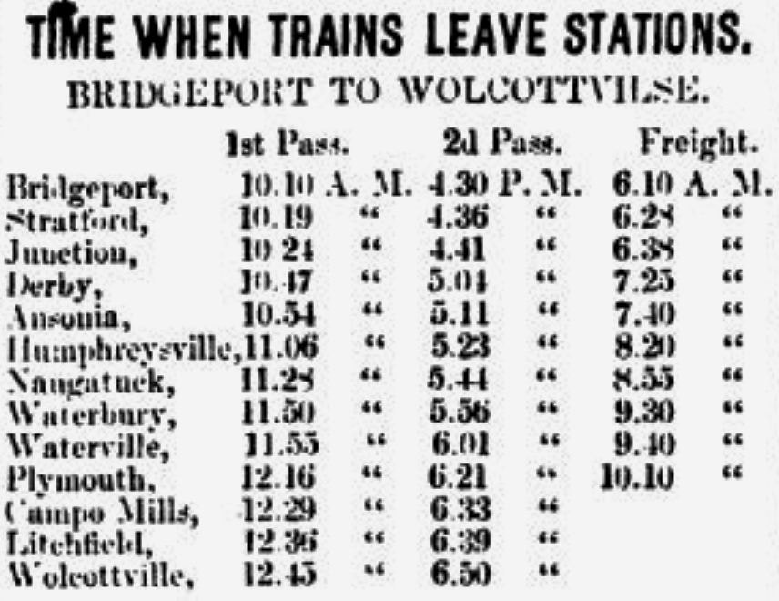
SEYMOUR1 [NRR, 1849; opens as HUMPHREYSVILLE]
For lack of a photo of this first station, we have borrowed borrowed the image of NAUGATUCK1. Most all of the early NRR stations looked like this: See ANSONIA1, TORRINTON1, WINSTED1. The location is shown on the 1856NH map at [2]]. Note the long siding with the reverse curve down to the Humphreys Ville Mfg. Co. This manufacturing concern was started by General David Humphries who had joined the Continental Army and became an aide-de-camp to George Washington in the Revolutionary War. The village was named HUMPHREYSVILLE in his honor, as seen on the 1849 timetable at [3]. Seymour was originally part of Derby but in May, 1850 the status of independent township was granted by the General Assembly. According to the town website, the renaming for the sitting governor, Thomas Hart Seymour, was part of what seems to have been a political compromise. [REFS: 1851, 1858TT][rev051722, 042923]
For lack of a photo of this first station, we have borrowed borrowed the image of NAUGATUCK1. Most all of the early NRR stations looked like this: See ANSONIA1, TORRINTON1, WINSTED1. The location is shown on the 1856NH map at [2]]. Note the long siding with the reverse curve down to the Humphreys Ville Mfg. Co. This manufacturing concern was started by General David Humphries who had joined the Continental Army and became an aide-de-camp to George Washington in the Revolutionary War. The village was named HUMPHREYSVILLE in his honor, as seen on the 1849 timetable at [3]. Seymour was originally part of Derby but in May, 1850 the status of independent township was granted by the General Assembly. According to the town website, the renaming for the sitting governor, Thomas Hart Seymour, was part of what seems to have been a political compromise. [REFS: 1851, 1858TT][rev051722, 042923]

Library of Congress
|
Seymour Historical Society
|

Seymour Historical Society
|
 Seymour Historical Society
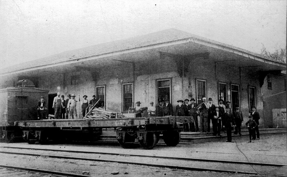
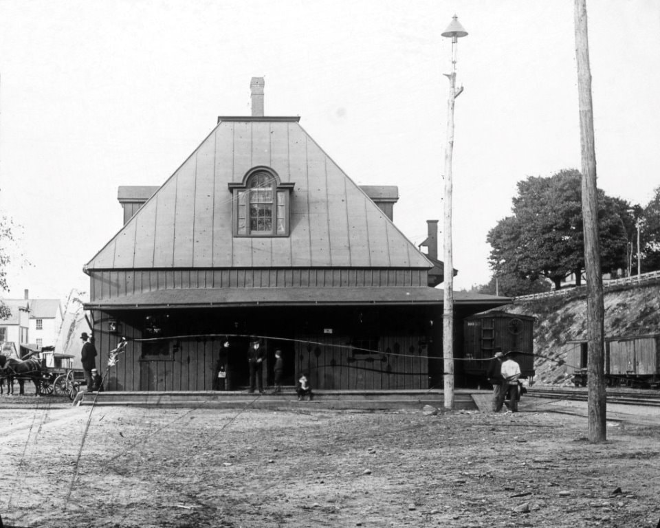
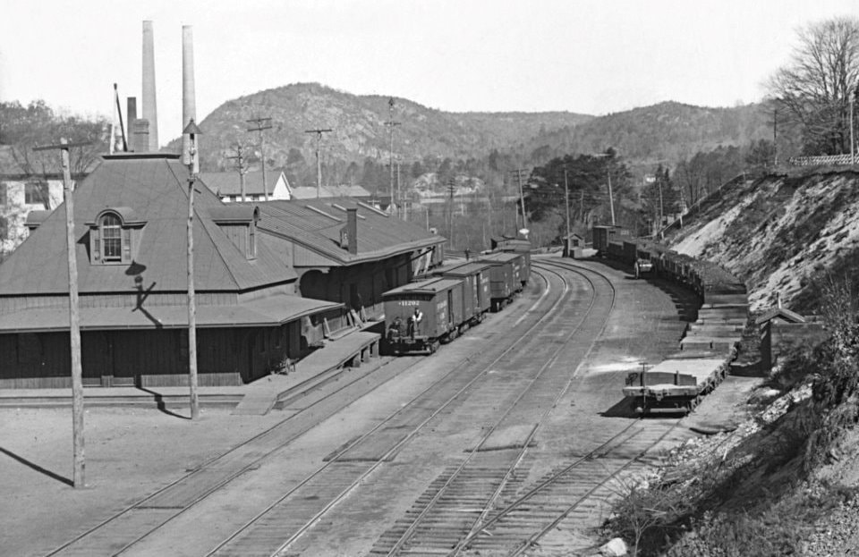
SEYMOUR2 [NRR, 1867]
The Hartford Courant reported in August, 1867 that "... The Naugatuck Railroad Company are now building a fine new passenger depot at Seymour. The new building is to be 30 by 34 feet, well fitted up and arranged, with the usual depot accommodations. It will be attached to the old depot, which will be used for a freight house." So we see the resulting combination station on the 1879 Bailey bird's-eye map at [1]. Note how James St. is a grade crossing at this point in time. The crystal clear images at [2] and [3] are 1890s glass plates. Side note: the Norwich Aurora uses the exact same text as the Courant in its issue of two days later, an indication that newspapers even at this early date were sharing via press associations. [REFS: HDC/08/05/1867/08; NA/08/07/1867/04][rev083113, 051922]
The Hartford Courant reported in August, 1867 that "... The Naugatuck Railroad Company are now building a fine new passenger depot at Seymour. The new building is to be 30 by 34 feet, well fitted up and arranged, with the usual depot accommodations. It will be attached to the old depot, which will be used for a freight house." So we see the resulting combination station on the 1879 Bailey bird's-eye map at [1]. Note how James St. is a grade crossing at this point in time. The crystal clear images at [2] and [3] are 1890s glass plates. Side note: the Norwich Aurora uses the exact same text as the Courant in its issue of two days later, an indication that newspapers even at this early date were sharing via press associations. [REFS: HDC/08/05/1867/08; NA/08/07/1867/04][rev083113, 051922]
|
|
Connecticut Digital Archive
|
|
|
Seymour Historical Society
|
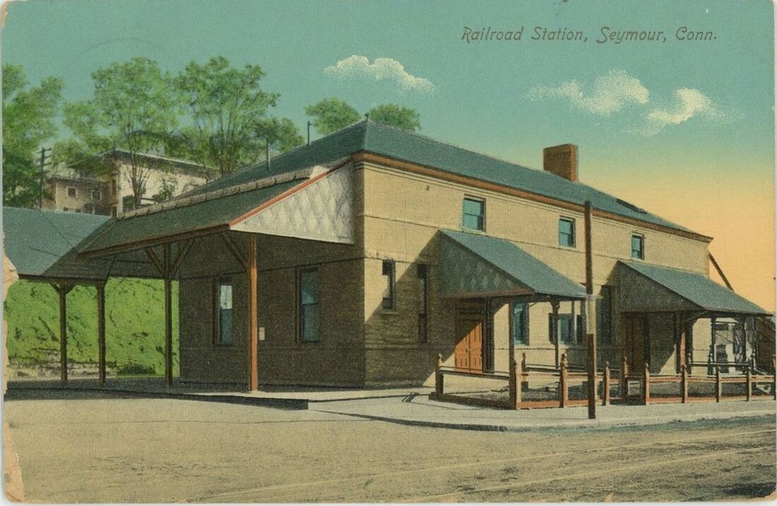
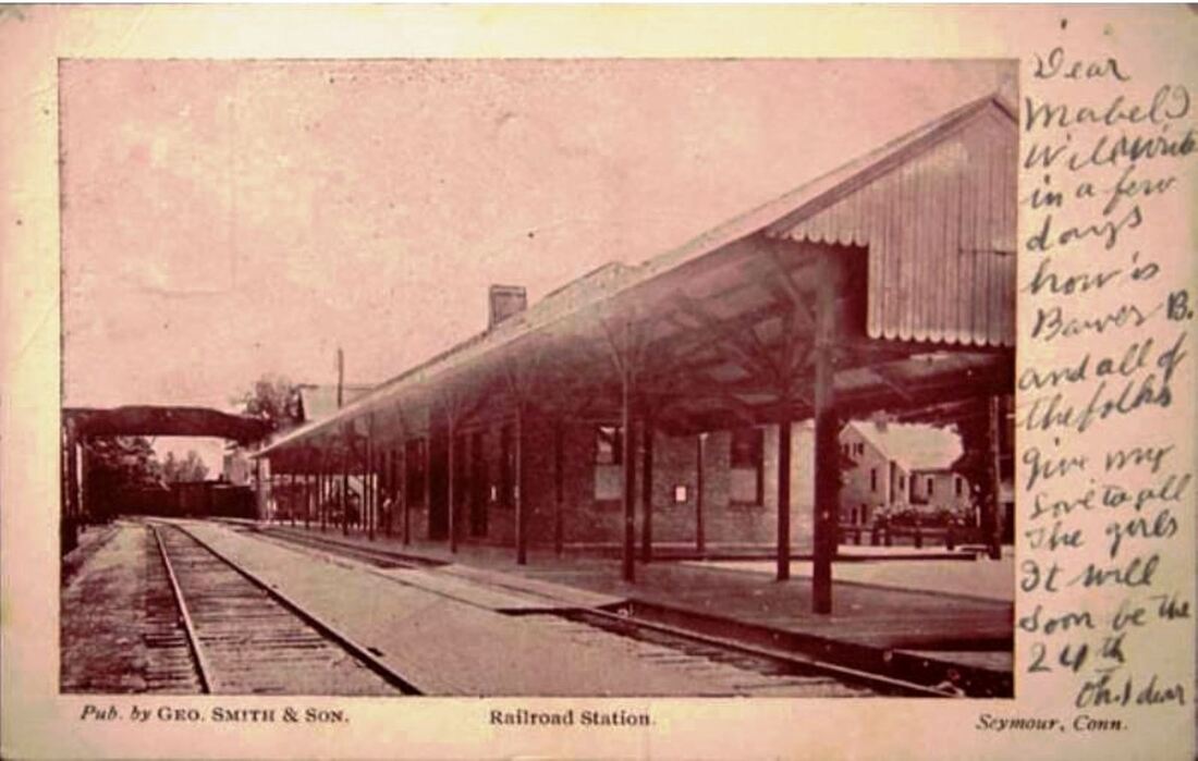
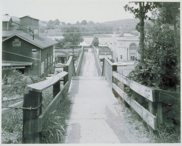
SEYMOUR3 [NYNH&H, 1898]
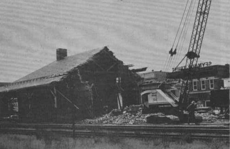
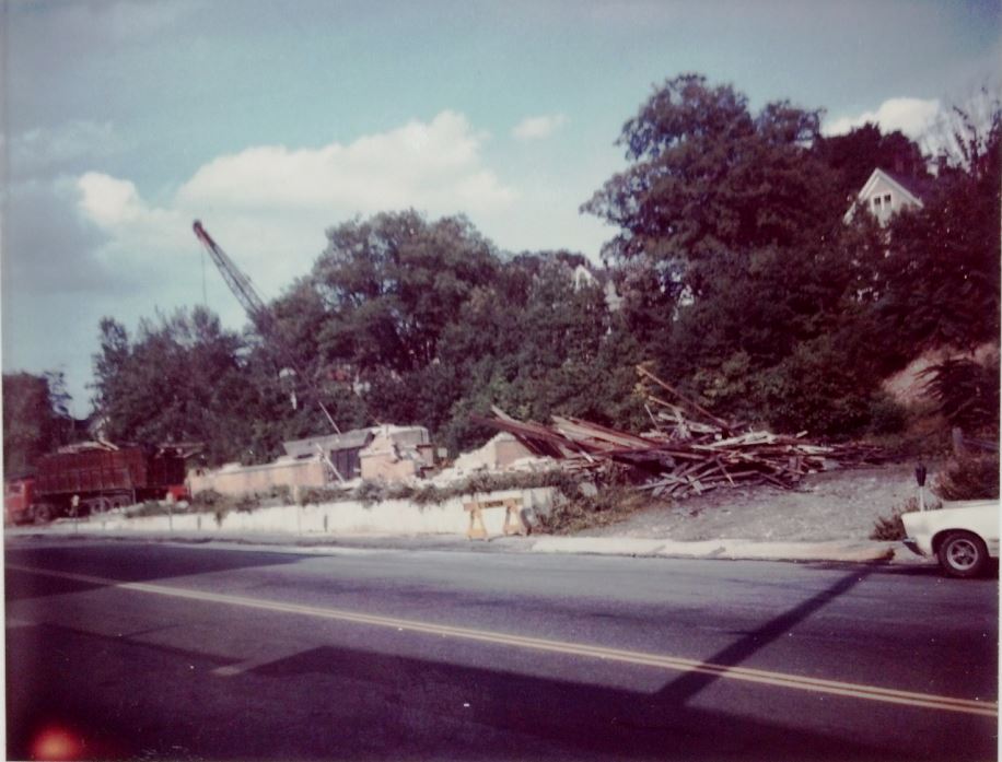
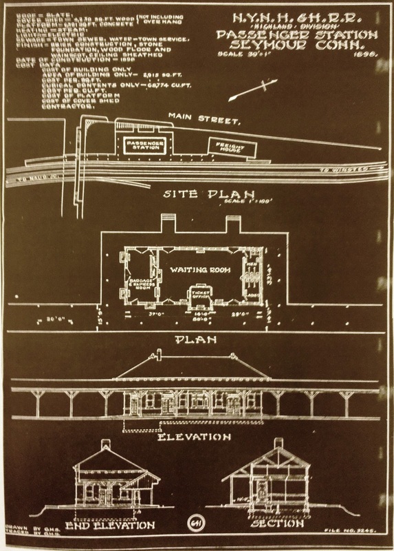
This station was of the two-story, hipped-roof design that the NYNH&H favored at larger stations ca. 1900: see NORWALK/N3,4, NORWICH/N3, STAMFORD3,4, TORRINGTON3. One newspaper said the new depot was almost finished in late July, 1898 but the Naugatuck Daily News, closer to home, pinpoints the opening to October 24, saying that "lighted by electric lights, it made a very handsome appearance... not only because it is an ornament to the town but because it was something greatly needed." The paper credited the Hon. Carlos French, a NYNH&H director, for his influence on fellow board members in seeing the earlier "old barn of a station removed," something that he had been wanting done for several years. The Waterbury Evening Democrat said with a sigh of regret that in this respect Seymour leads the Brass City; it would not get its new much grander station until 1909: see WATERBURY7. The annual report for 1899 gave $14,664.84 as the cost of SEYMOUR3. The card at [1] is postmarked February, 1914 and shows a street-side view of the station at its best. The card at [2] looks south on the track side and shows the pedestrian overpass for James St. in the distance. The 1961 image at [3] shows this walkway from the top down to the street and station. SEYMOUR3 lasted until just past the final days of the NYNH&H. No tickets had been sold here since 1963 and the building was no longer open, people apparently using only the platform. A Waterbury Republican article says the demolition started on 8/8/1969, as seen at [5]. After the town's negotiations to buy it for a recreation center failed, the property had been purchased by the Seymour Trust Co. for $25,550 with the 10,727 sq. ft. of land to be used for customer parking. Here as in other cities this was the rationale for razing old depots in th 1950s and 1960s as the NYNH&H chugged to its doom. The Naugatuck Valley Wrecking Co. did the deed, with locals watching and reminiscing about the 'good old days' when the railroad was a transportation force. The photo at [6] shows the ruins. The architectural tracing at [7] shows the plan for SEYMOUR3 dated 1898. Many thanks to Bill Sample and Rich Malley at RMNE for discovering the articles that nailed the demolition date, no pun intended! [REFS: CRC46.1898.19; NHAR28.1899.5; CWN/07/28/1898/03: NDN/10/28/1898/02; HC/09/18/1952/02; NDN/01/31/1953/04; WRE/08/09/1969/00; R88 says in error torn down on 2/30/1953][rev090322, 043023]
This station was of the two-story, hipped-roof design that the NYNH&H favored at larger stations ca. 1900: see NORWALK/N3,4, NORWICH/N3, STAMFORD3,4, TORRINGTON3. One newspaper said the new depot was almost finished in late July, 1898 but the Naugatuck Daily News, closer to home, pinpoints the opening to October 24, saying that "lighted by electric lights, it made a very handsome appearance... not only because it is an ornament to the town but because it was something greatly needed." The paper credited the Hon. Carlos French, a NYNH&H director, for his influence on fellow board members in seeing the earlier "old barn of a station removed," something that he had been wanting done for several years. The Waterbury Evening Democrat said with a sigh of regret that in this respect Seymour leads the Brass City; it would not get its new much grander station until 1909: see WATERBURY7. The annual report for 1899 gave $14,664.84 as the cost of SEYMOUR3. The card at [1] is postmarked February, 1914 and shows a street-side view of the station at its best. The card at [2] looks south on the track side and shows the pedestrian overpass for James St. in the distance. The 1961 image at [3] shows this walkway from the top down to the street and station. SEYMOUR3 lasted until just past the final days of the NYNH&H. No tickets had been sold here since 1963 and the building was no longer open, people apparently using only the platform. A Waterbury Republican article says the demolition started on 8/8/1969, as seen at [5]. After the town's negotiations to buy it for a recreation center failed, the property had been purchased by the Seymour Trust Co. for $25,550 with the 10,727 sq. ft. of land to be used for customer parking. Here as in other cities this was the rationale for razing old depots in th 1950s and 1960s as the NYNH&H chugged to its doom. The Naugatuck Valley Wrecking Co. did the deed, with locals watching and reminiscing about the 'good old days' when the railroad was a transportation force. The photo at [6] shows the ruins. The architectural tracing at [7] shows the plan for SEYMOUR3 dated 1898. Many thanks to Bill Sample and Rich Malley at RMNE for discovering the articles that nailed the demolition date, no pun intended! [REFS: CRC46.1898.19; NHAR28.1899.5; CWN/07/28/1898/03: NDN/10/28/1898/02; HC/09/18/1952/02; NDN/01/31/1953/04; WRE/08/09/1969/00; R88 says in error torn down on 2/30/1953][rev090322, 043023]
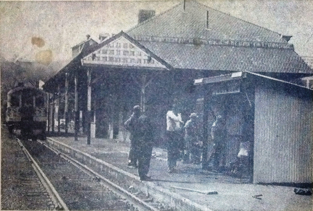
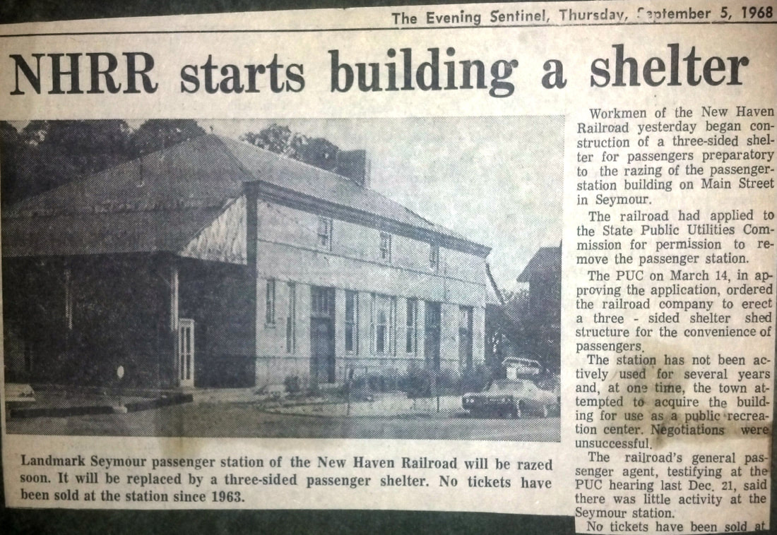
SEYMOUR4 [NYNHH, 1968]
Dwindling ridership at this stop caused the railroad to petition the PUC to substitute a shelter here for the old station, permission which was granted on 3/14/1968. The Ansonia Evening Sentinel headline "NH Starts Building a Shelter" carried the news that construction started on 9/4/1968. This shelter stood just to the south of SEYMOUR3. Workmen seen in this photo are putting the finishing touches on it later in 1968 as the Budd Car is still making its stop at the old station. This structure lasted into the PC era and presumably into Conrail until it was replaced by SEYMOUR5. Naugatuck Valley rail service was never restored to pre-1955 flood levels and had deteriorated to the point of using buses from 7/31/1978 because of bad track. The revival on 12/10/1979 was part of a $750G state investment in rail service that included the purchase of 13 new SPV cars for use on the New Canaan, Danbury, and Waterbury branch lines. [REFS: REFS: AES/09/05/1968/00; AES/11/29/1968/00; HC/12/07/1979/04][rev050323]
Dwindling ridership at this stop caused the railroad to petition the PUC to substitute a shelter here for the old station, permission which was granted on 3/14/1968. The Ansonia Evening Sentinel headline "NH Starts Building a Shelter" carried the news that construction started on 9/4/1968. This shelter stood just to the south of SEYMOUR3. Workmen seen in this photo are putting the finishing touches on it later in 1968 as the Budd Car is still making its stop at the old station. This structure lasted into the PC era and presumably into Conrail until it was replaced by SEYMOUR5. Naugatuck Valley rail service was never restored to pre-1955 flood levels and had deteriorated to the point of using buses from 7/31/1978 because of bad track. The revival on 12/10/1979 was part of a $750G state investment in rail service that included the purchase of 13 new SPV cars for use on the New Canaan, Danbury, and Waterbury branch lines. [REFS: REFS: AES/09/05/1968/00; AES/11/29/1968/00; HC/12/07/1979/04][rev050323]
|
|
|
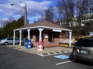
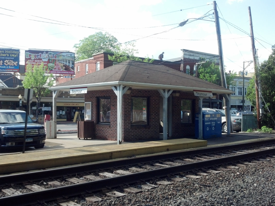
SEYMOUR5 [MN, 1990s?]
Our photos were taken on 5/27/2014. We have not yet found an exact opening date for this small, attractive, hip-roofed brick structure that now stands where SEYMOUR4 did previously. [REFS: R88][rev052022]
Our photos were taken on 5/27/2014. We have not yet found an exact opening date for this small, attractive, hip-roofed brick structure that now stands where SEYMOUR4 did previously. [REFS: R88][rev052022]
SHAILERVILLE [> ARNOLDS]

|

|
|
|
|
|
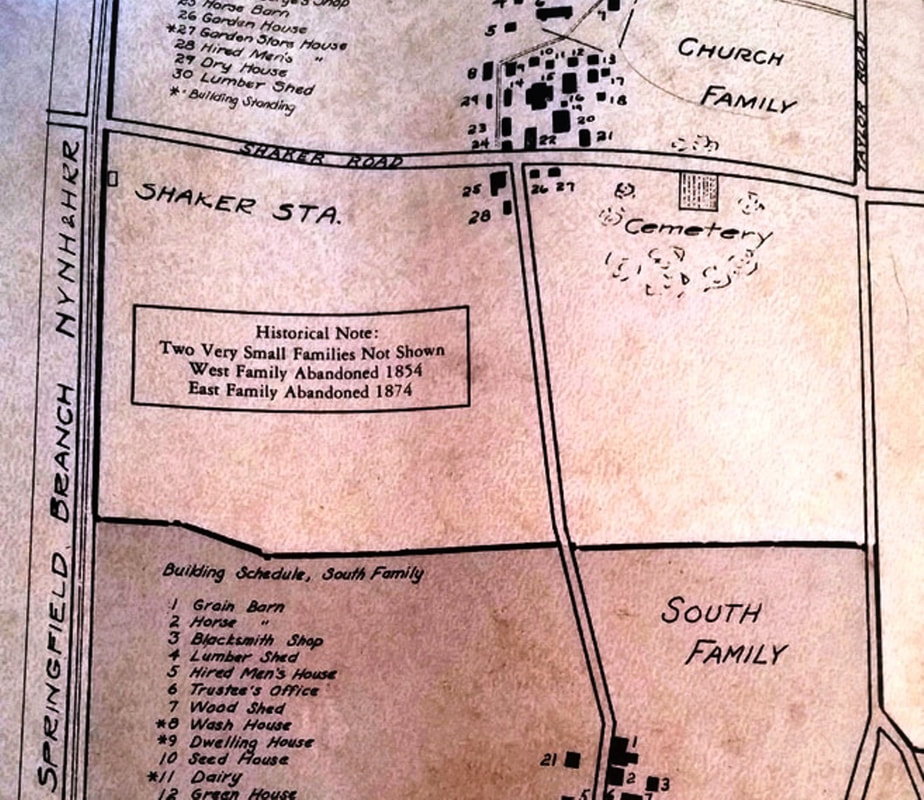
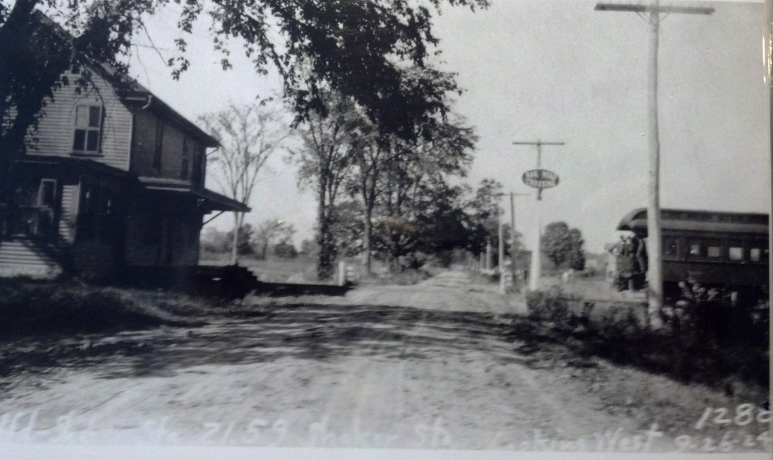
SHAKER STATION [CC, 1876]
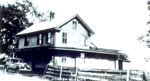
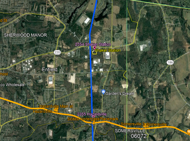
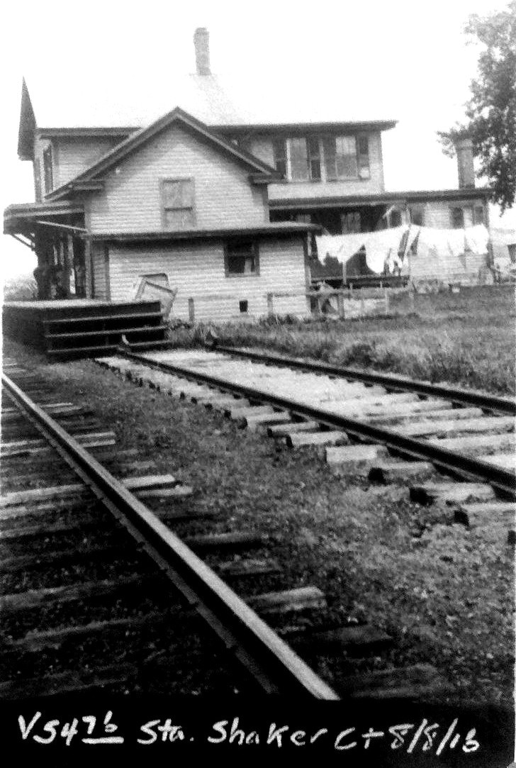
This was the last Connecticut Central stop in the state, about three miles south of the Massachusetts border. The depot was named for the religious community that settled the area in the town of Enfield in the 1780s. Additional passenger traffic came after the 1882 opening of Pine Point Grove on Shaker Lake and later other resorts as well. Freight traffic in and out was generated by famed Shaker apples, cider, corn and other produce, as well as stone from a nearby quarry and even some gunpowder from HAZARDVILLE. The image at [1] likely shows Sarah Twiss, wife of Station Agent John F. Twiss, who apparently held the position from the 1876 opening of the CC until his retirement in 1911, the couple making "a part of the [station] building their home." The exact origin of the residential-style structure is not known but railroads often came to possess buildings along the right of way, contracted for their use, or received them as donations on condition that the trains stop there. Our website namesake, TYLER CITY, is a prime example and others like this are seen at STEVENSON1 and elsewhere. The complex relationship between the U.S. Post Office and the railroads has always been interesting to us since the agent often wore both hats; changes in appointments to either or both positions are challenging to sort out, as is the changing of post office names to avoid conflict with others similarly titled in the same state, at times conflicting thereafter with the station name. A post office was established here in 1881 with John as postmaster but the position was eliminated on 8/2/1911 with the couple's retirement to East Longmeadow, MA and no one being interested in the job. The newspaper said in 1916 that John's death came two days after his wife was buried, a funeral which he was too ill to attend; both returned to be interred at the Enfield Street Cemetery. The rear of the station is seen in the westward view at [2]. The image at [3] is a ca. 1900 map showing the railroad station at middle left and some of the Shaker Family settlements at right. The PUC photo at [4] is dated 9/26/1924 and looks west at the grade crossing on the north side of the station. The image at [5] is a Lewis. H. Benton photo, we think #2354 which would date it to June, 1929. Irving Drake, fellow photographer and provider of transportation with the car at left, is seated on the steps of the station. The snippet from our Track 11 Google Earth map at [6] shows the depot/residence in the southeast corner of the Shaker Rd grade crossing. The 8/8/1916 val photo at [7] looks north and catches the household laundry hanging out to dry. The house track is seen dead-ending right at the porch which doubled as platform! Karr says passenger service on this branch ended ca. 1931 and trackage from Springfield to HAZARDVILLE was abandoned in 1993. Here as elsewhere, SHAKER STATION became synonymous with the larger community and a geographical locale like WILSONS, SHELDON STREET, and many others that the railroad put on the map. REFS: BH/02/14/1881/01; SR/06/27/1882/06; SR/12/20/1902/10; HC/01/09/1916/05; K120][rev021017, 043023]
This was the last Connecticut Central stop in the state, about three miles south of the Massachusetts border. The depot was named for the religious community that settled the area in the town of Enfield in the 1780s. Additional passenger traffic came after the 1882 opening of Pine Point Grove on Shaker Lake and later other resorts as well. Freight traffic in and out was generated by famed Shaker apples, cider, corn and other produce, as well as stone from a nearby quarry and even some gunpowder from HAZARDVILLE. The image at [1] likely shows Sarah Twiss, wife of Station Agent John F. Twiss, who apparently held the position from the 1876 opening of the CC until his retirement in 1911, the couple making "a part of the [station] building their home." The exact origin of the residential-style structure is not known but railroads often came to possess buildings along the right of way, contracted for their use, or received them as donations on condition that the trains stop there. Our website namesake, TYLER CITY, is a prime example and others like this are seen at STEVENSON1 and elsewhere. The complex relationship between the U.S. Post Office and the railroads has always been interesting to us since the agent often wore both hats; changes in appointments to either or both positions are challenging to sort out, as is the changing of post office names to avoid conflict with others similarly titled in the same state, at times conflicting thereafter with the station name. A post office was established here in 1881 with John as postmaster but the position was eliminated on 8/2/1911 with the couple's retirement to East Longmeadow, MA and no one being interested in the job. The newspaper said in 1916 that John's death came two days after his wife was buried, a funeral which he was too ill to attend; both returned to be interred at the Enfield Street Cemetery. The rear of the station is seen in the westward view at [2]. The image at [3] is a ca. 1900 map showing the railroad station at middle left and some of the Shaker Family settlements at right. The PUC photo at [4] is dated 9/26/1924 and looks west at the grade crossing on the north side of the station. The image at [5] is a Lewis. H. Benton photo, we think #2354 which would date it to June, 1929. Irving Drake, fellow photographer and provider of transportation with the car at left, is seated on the steps of the station. The snippet from our Track 11 Google Earth map at [6] shows the depot/residence in the southeast corner of the Shaker Rd grade crossing. The 8/8/1916 val photo at [7] looks north and catches the household laundry hanging out to dry. The house track is seen dead-ending right at the porch which doubled as platform! Karr says passenger service on this branch ended ca. 1931 and trackage from Springfield to HAZARDVILLE was abandoned in 1993. Here as elsewhere, SHAKER STATION became synonymous with the larger community and a geographical locale like WILSONS, SHELDON STREET, and many others that the railroad put on the map. REFS: BH/02/14/1881/01; SR/06/27/1882/06; SR/12/20/1902/10; HC/01/09/1916/05; K120][rev021017, 043023]
|

|
|
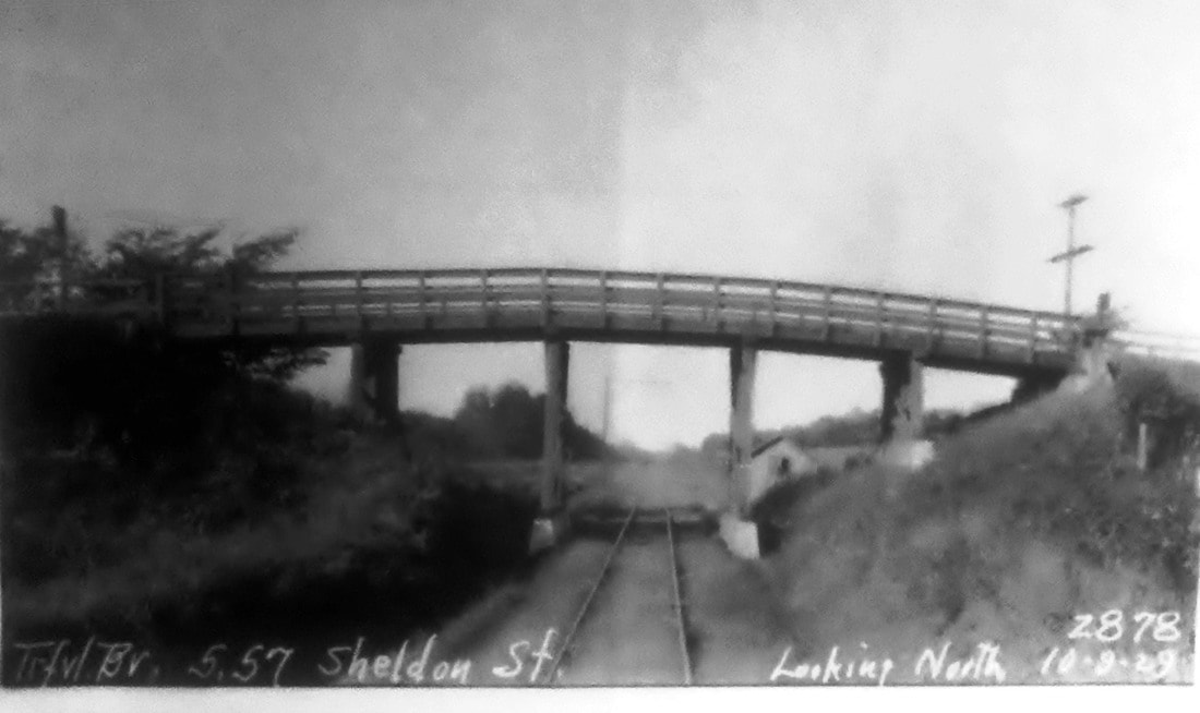
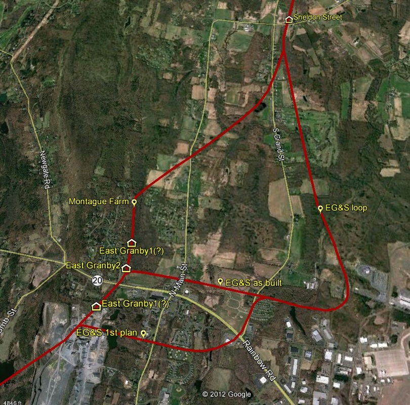
SHELDON STREET [CNE, 1903]
This stop in the town of Suffield was established in 1903 along with FREEMANS. A March, 1903 newspaper article says that "the Central New England railroad has established a flag station at Ward's corner, near the Suffield and East Granby town lines" and probably refers to this station, though the Wards Corner reference has eluded us. Coincidentally, this was near the northerly point where the short-lived East Granby and Suffield RR rejoined the main line. See EAST GRANBY2 and TARIFFVILLE3 for more on the story of how the CNE was forced to build the EG&S loop as part of the Montague Farm controversy. The PUC inspection photo at [1] appears to be dated 10/9/1929 and shows the small waiting shed in the distance, northeast of the overpass for Sheldon St., 5.7 miles north of Tariffville. The 1916 val map at [2] shows the station layout and the snippet at [3] from our Track 11 Google Earth map places SHELDON STREET, which is seen at the very top, in the context of the area. The thoroughfare itself was styled after a local family of some importance and the name Sheldon Street appears often in the newspapers referring to the local school district and a neighborhood that was familiar to many as a geographic point of reference. [REFS: SR/11/17/1902/08; SR/03/03/1903/10; B258.230][rev020417]
This stop in the town of Suffield was established in 1903 along with FREEMANS. A March, 1903 newspaper article says that "the Central New England railroad has established a flag station at Ward's corner, near the Suffield and East Granby town lines" and probably refers to this station, though the Wards Corner reference has eluded us. Coincidentally, this was near the northerly point where the short-lived East Granby and Suffield RR rejoined the main line. See EAST GRANBY2 and TARIFFVILLE3 for more on the story of how the CNE was forced to build the EG&S loop as part of the Montague Farm controversy. The PUC inspection photo at [1] appears to be dated 10/9/1929 and shows the small waiting shed in the distance, northeast of the overpass for Sheldon St., 5.7 miles north of Tariffville. The 1916 val map at [2] shows the station layout and the snippet at [3] from our Track 11 Google Earth map places SHELDON STREET, which is seen at the very top, in the context of the area. The thoroughfare itself was styled after a local family of some importance and the name Sheldon Street appears often in the newspapers referring to the local school district and a neighborhood that was familiar to many as a geographic point of reference. [REFS: SR/11/17/1902/08; SR/03/03/1903/10; B258.230][rev020417]
|
|
|
SHELDONS [NH&D, 1871]
The newspaper reported in August, 1871 on the opening of the NHD that a flag stop known as ALLINGS CROSSING "... near Fresh Meadow Swamp... " had been established in the town of Orange. The 12/4/1871 NH&D timetable at [1] shows it officially as SHELDONS, here spelled as Sheldens. The left arrow on the 1868 map at [2] points to the home of J. Sheldon Alling, prominent local resident and the right arrow points to the crossing known variously by both his middle and surname. The snippet from our Track 11 Google Earth map at [3] shows the location on today's Dogwood Rd. This stop, along with BRADLEYS on Racebrook Rd., was shortlived, eliminated when the station at TYLER CITY opened midway between them in June, 1872. See also Track 4B, MP 4.41.3. [REFS: DTR/08/11/1871/02; NHJC/11/20/1871/02; NHDP/06/06/1872/04; RRM1876][rev072915, 043023]
The newspaper reported in August, 1871 on the opening of the NHD that a flag stop known as ALLINGS CROSSING "... near Fresh Meadow Swamp... " had been established in the town of Orange. The 12/4/1871 NH&D timetable at [1] shows it officially as SHELDONS, here spelled as Sheldens. The left arrow on the 1868 map at [2] points to the home of J. Sheldon Alling, prominent local resident and the right arrow points to the crossing known variously by both his middle and surname. The snippet from our Track 11 Google Earth map at [3] shows the location on today's Dogwood Rd. This stop, along with BRADLEYS on Racebrook Rd., was shortlived, eliminated when the station at TYLER CITY opened midway between them in June, 1872. See also Track 4B, MP 4.41.3. [REFS: DTR/08/11/1871/02; NHJC/11/20/1871/02; NHDP/06/06/1872/04; RRM1876][rev072915, 043023]
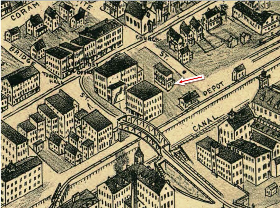
SHELTON1 [NH&D, 1888]
This was established as an NH&D station in what was a borough in the town of Huntington in 1888. Space was reportedly rented in the basement of a structure adjacent to the track. The red arrow on the snippet from the Landis & Hughes 1898 bird's-eye view of Derby, Shelton and East Derby points to the building that may have been SHELTON1, with the lower level cut into the hill. According to the newspaper, it was not elegant but it was large, clean, comfortable and convenient. R&LHS notes at the Baker Library show a rental expense of $15, presumably monthly, on 8/31/1892. According to subsequent reports, it was "uninviting" and lacking signage. [REFS: NBE/04/05/1889/02; NHER/10/15/1892/01; B861][rev022018, 043023]
This was established as an NH&D station in what was a borough in the town of Huntington in 1888. Space was reportedly rented in the basement of a structure adjacent to the track. The red arrow on the snippet from the Landis & Hughes 1898 bird's-eye view of Derby, Shelton and East Derby points to the building that may have been SHELTON1, with the lower level cut into the hill. According to the newspaper, it was not elegant but it was large, clean, comfortable and convenient. R&LHS notes at the Baker Library show a rental expense of $15, presumably monthly, on 8/31/1892. According to subsequent reports, it was "uninviting" and lacking signage. [REFS: NBE/04/05/1889/02; NHER/10/15/1892/01; B861][rev022018, 043023]
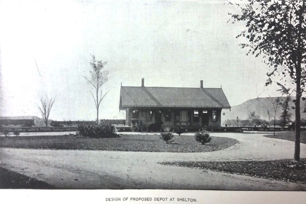
|
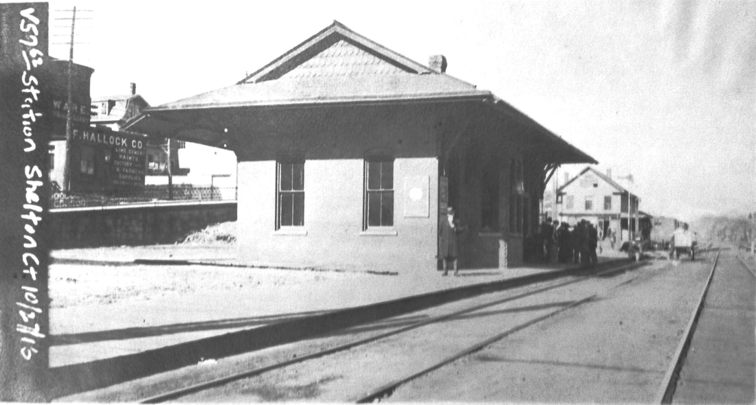
National Archives
|

|

Dirienzo Collection
|
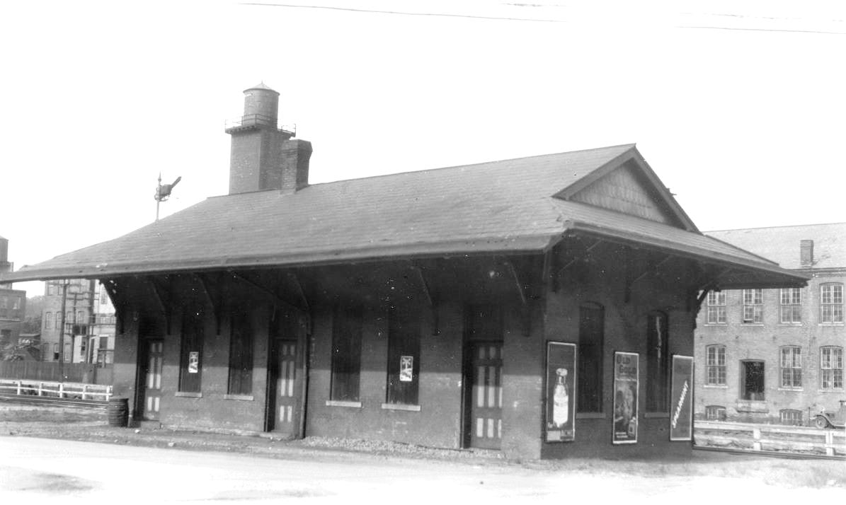
|

|
SHELTON2 [NYNH&H, 1893]
NH&D Pres. Stevenson came to town in August, 1890, "... with a view to locating the depot on Canal St. The image at [1] appears in the 1890 Illustrated Review of the Naugatuck Valley [p41] as proposed depot at Shelton. The exact same photo shows up in in the HRR's 1892 publication Along the Housatonic Lines [p11] as Stockbridge, MA. Typical of the HRR stations of the era, this was apparently what was planned for Shelton. Work was about to begin on 10/24/1890 but it was never built. The one that was finally built was just after the 1892 takeover of the NH&D/HRR by the NYNH&H and is seen in the rest of the photos: brick, single-chimney, hipped roof with broken-end gables. The Register reported in October, 1892 that "a new brick passenger station has been built, and the interior is being finished off" and it had cost about $5,000. According to R&LHS notes and the Newtown Bee, the opening was on 2/1/1893, the latter commenting that it was " a great improvement over the uninviting underground room that has so long been used without even a sign to indicate its occupancy." The Bee noted in March that "... our new and pleasant little depot has had its front graced with the sign 'Shelton,' so that visitors will henceforth know 'what place we are at,'" point taken! The ICC valuation photo at [2] is dated 10/27/1916 and Irving Drake's handwriting at [3] notes the view on 5/11/1934; both look railroad-west. The postcard at [4] shows cars at the freight house and a spur trackage on the other side of the canal to serve factories there. The undated image at [5] shows a street-side view of the 1893 depot. The view at [6] shows the massive water tank towering over the station and standpipe beyond the first hopper car. When the service cutbacks came in 1925, residents of Shelton appealed to the PUC. George F. Willis, president of the Shelton Chamber of Commerce, declared that the New Haven had abandoned the passenger station in town without permission and requested a hearing on the matter. There is no further mention in the newspaper but the PUC records at the state library should tell the story of how the abandonment of this station was handled. There was a law on the books requiring hearings and permission from the railroad commissioners, later the PUC, before stations could be abandoned but this case may have broken new ground because passenger service was being cut on the whole line. Our 8/21/1927PTT has the first combined DERBY-SHELTON listing that we have seen, meaning that riders now had go to Derby to pick up trains on the NRR line. The other Extension stations, STEVENSON and MONROE, also no longer appear in the index. Riders from those points were apparently expected to go to STEPNEY, PEPPER CROSSING, or BOTSFORD to catch trains on the HRR main line which retained passenger service until 1932. The 1938 SSRR list shows this station as having been sold for $225 but it was to remain on railroad land. The 3/23/1961 buildings inventory says SHELTON2 was still standing but no longer owned by the railroad. It was reportedly razed in the 1970s. [REFS: NBE/10/24/1890/05; NBE/02/10/1893/05; NBE/03/03/1893/06; HC/10/09/1925/22; B878; K57; R89][rev022018, 043023]
NH&D Pres. Stevenson came to town in August, 1890, "... with a view to locating the depot on Canal St. The image at [1] appears in the 1890 Illustrated Review of the Naugatuck Valley [p41] as proposed depot at Shelton. The exact same photo shows up in in the HRR's 1892 publication Along the Housatonic Lines [p11] as Stockbridge, MA. Typical of the HRR stations of the era, this was apparently what was planned for Shelton. Work was about to begin on 10/24/1890 but it was never built. The one that was finally built was just after the 1892 takeover of the NH&D/HRR by the NYNH&H and is seen in the rest of the photos: brick, single-chimney, hipped roof with broken-end gables. The Register reported in October, 1892 that "a new brick passenger station has been built, and the interior is being finished off" and it had cost about $5,000. According to R&LHS notes and the Newtown Bee, the opening was on 2/1/1893, the latter commenting that it was " a great improvement over the uninviting underground room that has so long been used without even a sign to indicate its occupancy." The Bee noted in March that "... our new and pleasant little depot has had its front graced with the sign 'Shelton,' so that visitors will henceforth know 'what place we are at,'" point taken! The ICC valuation photo at [2] is dated 10/27/1916 and Irving Drake's handwriting at [3] notes the view on 5/11/1934; both look railroad-west. The postcard at [4] shows cars at the freight house and a spur trackage on the other side of the canal to serve factories there. The undated image at [5] shows a street-side view of the 1893 depot. The view at [6] shows the massive water tank towering over the station and standpipe beyond the first hopper car. When the service cutbacks came in 1925, residents of Shelton appealed to the PUC. George F. Willis, president of the Shelton Chamber of Commerce, declared that the New Haven had abandoned the passenger station in town without permission and requested a hearing on the matter. There is no further mention in the newspaper but the PUC records at the state library should tell the story of how the abandonment of this station was handled. There was a law on the books requiring hearings and permission from the railroad commissioners, later the PUC, before stations could be abandoned but this case may have broken new ground because passenger service was being cut on the whole line. Our 8/21/1927PTT has the first combined DERBY-SHELTON listing that we have seen, meaning that riders now had go to Derby to pick up trains on the NRR line. The other Extension stations, STEVENSON and MONROE, also no longer appear in the index. Riders from those points were apparently expected to go to STEPNEY, PEPPER CROSSING, or BOTSFORD to catch trains on the HRR main line which retained passenger service until 1932. The 1938 SSRR list shows this station as having been sold for $225 but it was to remain on railroad land. The 3/23/1961 buildings inventory says SHELTON2 was still standing but no longer owned by the railroad. It was reportedly razed in the 1970s. [REFS: NBE/10/24/1890/05; NBE/02/10/1893/05; NBE/03/03/1893/06; HC/10/09/1925/22; B878; K57; R89][rev022018, 043023]
SHEPAUG1 [SRR, 1872]
This appears to have been an original Southbury stop on the Shepaug RR when the road opened in 1872. This location was actually known as the village of Southville, small but vibrant community which was wiped out when the Shepaug Dam was completed by Connecticut Light & Power in 1955. There are newspaper mentions of stage service to "Shepaug Station" as early as 1873 and the stop is listed on the January, 1874 Travelers' Official Guide timetable seen here. The last rail for the SRR was laid at about 11:00 a.m. on 12/7/1871 at LITCHFIELD, the same day as the last rail was tapped into place on the CW at 2:00 p.m. in NORFOLK. SRR trains initially ran from LITCHFIELD to HAWLEYVILLE and in 1872 all the way to (SOUTH) NORWALK via the BETHEL Extension built jointly with the D&N. The buzzing Bee tells us in 1898 that the Shepaug was tearing down the station here and intending to put up a new one. We have no photo of SHEPAUG1. REFS: HDC/11/08/1871/04; HDC/12/09/1871/03; WH/07/02/1872/02; LEN/02/06/1873/03; NBE/03/18/1898/03][rev 4/16/2014, 6/23/2022]
This appears to have been an original Southbury stop on the Shepaug RR when the road opened in 1872. This location was actually known as the village of Southville, small but vibrant community which was wiped out when the Shepaug Dam was completed by Connecticut Light & Power in 1955. There are newspaper mentions of stage service to "Shepaug Station" as early as 1873 and the stop is listed on the January, 1874 Travelers' Official Guide timetable seen here. The last rail for the SRR was laid at about 11:00 a.m. on 12/7/1871 at LITCHFIELD, the same day as the last rail was tapped into place on the CW at 2:00 p.m. in NORFOLK. SRR trains initially ran from LITCHFIELD to HAWLEYVILLE and in 1872 all the way to (SOUTH) NORWALK via the BETHEL Extension built jointly with the D&N. The buzzing Bee tells us in 1898 that the Shepaug was tearing down the station here and intending to put up a new one. We have no photo of SHEPAUG1. REFS: HDC/11/08/1871/04; HDC/12/09/1871/03; WH/07/02/1872/02; LEN/02/06/1873/03; NBE/03/18/1898/03][rev 4/16/2014, 6/23/2022]
National Archives
|
Litchfield Historical Society
|
Dave Peters Collection
|
|
NHRHTA Collection
|
|
 National Archives
SHEPAUG2 [SLN, 1898]
We think it wiser to go with the Bee date of 1898, as cited in the previous entry, for the completion of this structure, not the 1897 on the real estate card, which is often inaccurate. This was among the last actions of what had become the Shepaug, Litchfield & Northern RR in June, 1887 and by July of 1898 had been leased by its stockholders for 75 years to the NYNH&H. A gas rail car, by then running to DANBURY via HAWLEYVILLE, took over passenger duties from April, 1922 until April, 1927. Service was restored by court order in November, 1927 with a coach attached to the daily freight train until April 27, 1930. Ed Brady tells us that, in the meanwhile, SHEPAUG2 burned on 8/20/1927 and was never replaced and, coincidentally, a 1928 timetable no longer shows this as a stop. Thereafter four, later three, freights ran until the final trip on 6/25/1948, with crowds gathering to mark the demise. Among the reasons for the shutdown was the fact that the NYNH&H was barely making money operating the branch and the planning of the Shepaug Dam would have required exorbitant expense in relocating the Shepaug line. Brady tells us the six-span "great bridge" over the Housatonic River was 482 feet long and built in 1908, according to Charlie Dunn the fourth built here. The station site has been under water since the building of the dam, the largest in Connecticut. Work began in 1953 and operations started in October, 1955. Gov. Ribicoff dedicated it on 5/23/1956. Lake Lillinoah, named for legendary local Native American princess, was created in the process and still serves as a great recreational resource today.
IMAGES: [1] 10/9/1916 valuation photo; [2] undated, ca. 1900, real estate card; [3] gas rail car on the SL&N; [4] 1934 aerial map showing curved bridge over the Housatonic at its confluence of the Shepaug River; [5] bridge photo before removal in 1948; [6] Track 12 Google Earth map snippet showing location of station, dam to the south; [7] 7/19/1917 val photo of water tank just north of the station. REFERENCES: 12/2/23 Form 220TT: yes; Form 200, 11/18/1928: Litchfield service but no stop here; NETCo 2/27/1930: no; Form 200 2/8/1932 says see NETCo; George J. Flynn, "Puritan Valley Line," Railroad Magazine 45.3.46ff (April, 1948) written while the line was up for abandonment; NYT/06/03/1953/25; NYT/10/25/1954/29; HC/05/24/1956/8A; NYT/05/24/1956/33; Fletcher E. Cooper, The Shepaug Railroad, 1872-1948, 2002, p8-9; Edward J. Brady, "The Shepaug Valley RR. Born 1866, Died 1949," unpaged typescript memoir at LHS; C.B. Burr, The Railroad Enthusiast, 10.1.4 (April, 1943) "The 'Shepaug,'" p5,6: summer camp trains in 1942. TCS REVISIONS: 4/16/2014, 6/23/2022, 043023]
SHORE LINE JUNCTION [> MILL RIVER JUNCTION]

National Archives
|
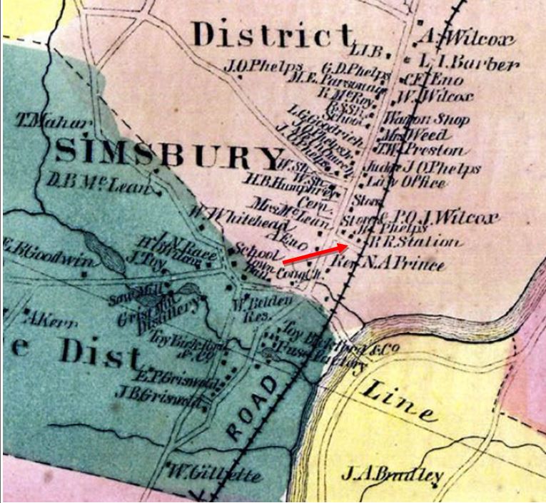
|
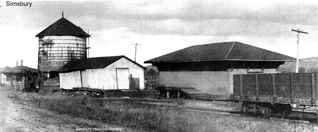
|

SIMSBURY1 [NH&N, 1850]
This was the first station in town, built by the NY&NH during the period when it was leasing the Canal road. The Canal road regained its independence in 1869 and began to improve its property, building SIMSBURY3 in 1874, at which time this structure was moved down the track and used as its freight depot. It is seen as such on the 6/22/1917 ICC valuation photo at [1]. The location is seen on the 1869 map at [2]. The style is similar to depots it built at AVON and GRANBY, both still extant, the trio being the oldest stations standing in the state. The long shot at [3] shows SIMSBURY1 on the far right and, moving to the left, the early CW freight house, the old wooden water tank and SIMSBURY4 in the distance. Local architect Allen Hixon purchased, moved and restored SIMSBURY1 in 1980. It still stands about 300 ft south of its freight-era location, as seen in the shot at [4]. [REFS: HC/02/11/1980/17A; D20+; N3.21; R89][rev021819, 043023]
This was the first station in town, built by the NY&NH during the period when it was leasing the Canal road. The Canal road regained its independence in 1869 and began to improve its property, building SIMSBURY3 in 1874, at which time this structure was moved down the track and used as its freight depot. It is seen as such on the 6/22/1917 ICC valuation photo at [1]. The location is seen on the 1869 map at [2]. The style is similar to depots it built at AVON and GRANBY, both still extant, the trio being the oldest stations standing in the state. The long shot at [3] shows SIMSBURY1 on the far right and, moving to the left, the early CW freight house, the old wooden water tank and SIMSBURY4 in the distance. Local architect Allen Hixon purchased, moved and restored SIMSBURY1 in 1980. It still stands about 300 ft south of its freight-era location, as seen in the shot at [4]. [REFS: HC/02/11/1980/17A; D20+; N3.21; R89][rev021819, 043023]
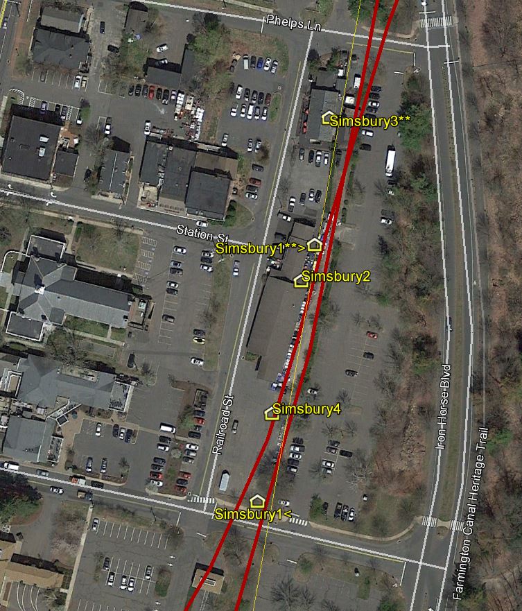
SIMSBURY2 [CW, 1873]
This town was said to be among those where progress "was in a more backward state" in terms of initial CW depot construction when it opened late in 1871. There was apparently nothing but a platform here until May, 1873, when the Winsted Herald reported that "the Conn. Western railroad have just erected a huge and commodious depot at the corner of Phelps Avenue and Railroad street, and directly opposite that ante-diluvial and dilapidated structure, known as the Canal R.R. depot. [SIMSBURY1]" This would put it at the foot of today's Station St., as seen on the map. The Collinsville correspondent for the Courant commented on his Herald counterpart being "rather facetious" about the new depot in Simsbury, saying that Collinsville, where an old shoemaker's shop was serving passengers [see COLLINSVILLE/J1], also hoped for better from the CW in the future. The jocularity continued when the Herald would later call SIMSBURY2 a "magnificent structure," measuring a tidy 11x18-ft with rough chestnut shingles on the exterior. Inside, it was said to be partitioned across the center, "with boards standing upright," the southerly part being used for freight and the other part being used for passengers. Outside, a five-foot wide platform, "substantially built with old timbers, cob-house fashion," stood three feet off the ground and it was said that "ladies and children can easily get on the cars, (if they can get on the platform)"(!). This depot was located about 35 rods (580 feet) south of the new Canal line station, SIMSBURY3, travel between the two was difficult because of the unevenness of the ground and the presence of felled apple trees. Another article in the Herald in 1875 pokes fun again, saying: "A few days ago some of the section hands started to carry away the C.W. depot to eat their dinner in, but the watchful agent overhauled them and caused them to drop it like a hot potato." We have no photo yet of this apparently diminutive and ramshackle structure. This small size is backed up in 1880 when the NY&NE valued the CW property for a prospective lease and they reported a structure for passengers and freight here that needed no repairs but was worth a mere $75! [REFS: WH/12/15/1871/02; WH/05/16/1873/02; HDC/05/19/ 1873/01; WH/07/21/1874/02; WH/01/08/1875/02; CW/NYNE 1880 lease][rev121617]
This town was said to be among those where progress "was in a more backward state" in terms of initial CW depot construction when it opened late in 1871. There was apparently nothing but a platform here until May, 1873, when the Winsted Herald reported that "the Conn. Western railroad have just erected a huge and commodious depot at the corner of Phelps Avenue and Railroad street, and directly opposite that ante-diluvial and dilapidated structure, known as the Canal R.R. depot. [SIMSBURY1]" This would put it at the foot of today's Station St., as seen on the map. The Collinsville correspondent for the Courant commented on his Herald counterpart being "rather facetious" about the new depot in Simsbury, saying that Collinsville, where an old shoemaker's shop was serving passengers [see COLLINSVILLE/J1], also hoped for better from the CW in the future. The jocularity continued when the Herald would later call SIMSBURY2 a "magnificent structure," measuring a tidy 11x18-ft with rough chestnut shingles on the exterior. Inside, it was said to be partitioned across the center, "with boards standing upright," the southerly part being used for freight and the other part being used for passengers. Outside, a five-foot wide platform, "substantially built with old timbers, cob-house fashion," stood three feet off the ground and it was said that "ladies and children can easily get on the cars, (if they can get on the platform)"(!). This depot was located about 35 rods (580 feet) south of the new Canal line station, SIMSBURY3, travel between the two was difficult because of the unevenness of the ground and the presence of felled apple trees. Another article in the Herald in 1875 pokes fun again, saying: "A few days ago some of the section hands started to carry away the C.W. depot to eat their dinner in, but the watchful agent overhauled them and caused them to drop it like a hot potato." We have no photo yet of this apparently diminutive and ramshackle structure. This small size is backed up in 1880 when the NY&NE valued the CW property for a prospective lease and they reported a structure for passengers and freight here that needed no repairs but was worth a mere $75! [REFS: WH/12/15/1871/02; WH/05/16/1873/02; HDC/05/19/ 1873/01; WH/07/21/1874/02; WH/01/08/1875/02; CW/NYNE 1880 lease][rev121617]

|
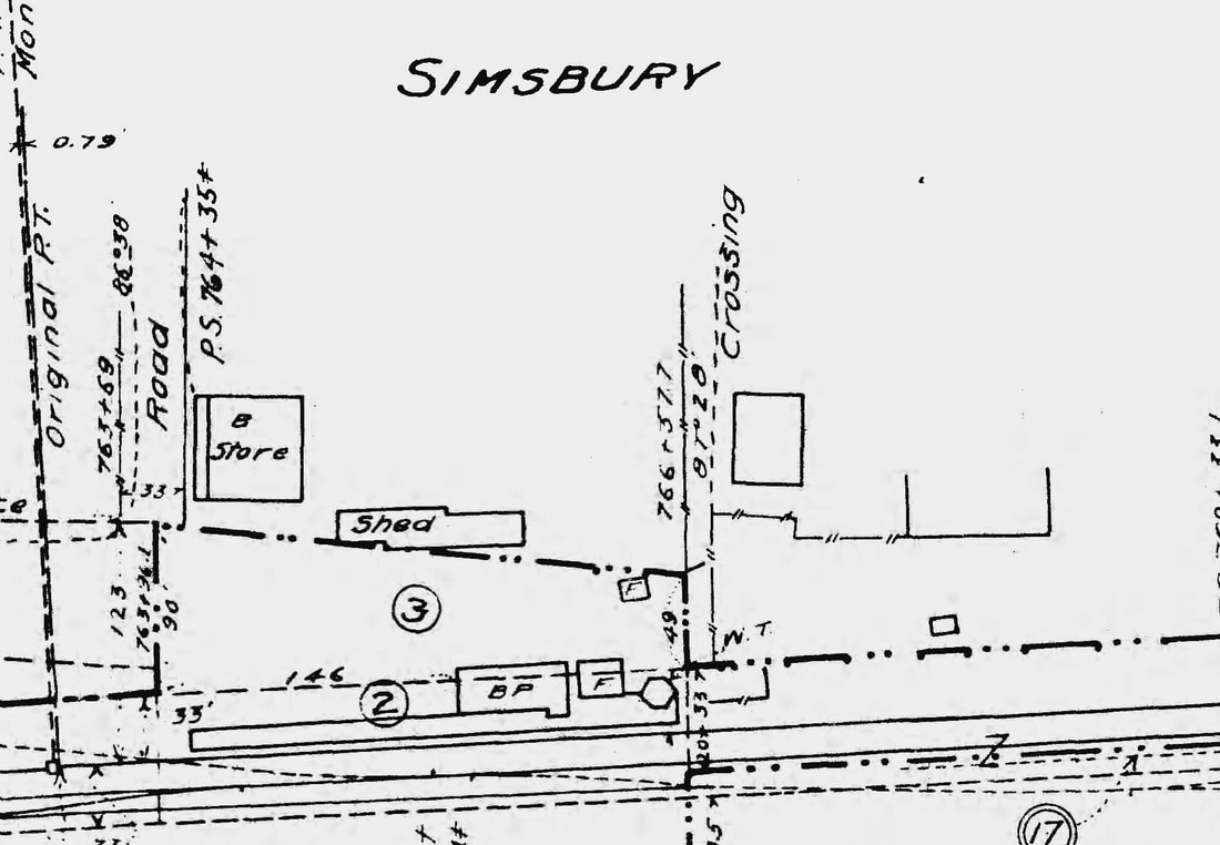
|
|
SIMSBURY3 [NH&N, 1874]
The railroad commissioners mention this new station in their 1875 annual report. The Winsted Herald pins down the debut to July, 1874, saying that "the Canal R. R. Co. have just completed a very respectable depot and placed it about 30 rods north of the old one -- a very improper place." Why this location was said to be unsatisfactory is not disclosed. The station's Italianate design was similar to other Canal line depots of the period, e.g. UNIONVILLE2 and SOUTHINGTON2. This would become the sole station in town possibly in 1908 when the CNE, controlled by the NYNH&H since 1904, would also start using it. A newspaper article in that year perhaps implies the recent closing of SIMSBURY4 (see next entry). It complained that "... the Consolidated railroad... could give the people of Simsbury a better depot, at least... it could be put in decent shape, and the surroundings be made more in accord with what should exist in an up-to-date town. With the old Central New England depot abandoned, and only one building to be be kept in repair and with the amount of traffick that there is at this station, the railroad should give its patrons a better place in which to wait for trains." The photo at [1] dates to ca. 1900 and shows the small baggage building and the brick-enclosed water tank north of the station. The 1916 ICC valuation map at [2] reflects the new arrangement, including the 'F' framed, wooden baggage building and brick-enclosed water tank to the north, seen as the hexagon on on the val map. The photo at [3] shows a Canal line train passing the switch for the CW track that is angling to the southwest toward the Hopmeadow St. crossing. SIMSBURY4 is out of sight to the left. At [4] is a recent shot of SIMSBURY3 which has gone through several reincarnations as a restaurant. [REFS: WH/07/21/1874/02; HC/08/15/1974/66B; HC/12/13/1975/30A; CRC22.1875.34; D112; Nimke has 1913 map saying joint use; R89][rev082319, 043023]
The railroad commissioners mention this new station in their 1875 annual report. The Winsted Herald pins down the debut to July, 1874, saying that "the Canal R. R. Co. have just completed a very respectable depot and placed it about 30 rods north of the old one -- a very improper place." Why this location was said to be unsatisfactory is not disclosed. The station's Italianate design was similar to other Canal line depots of the period, e.g. UNIONVILLE2 and SOUTHINGTON2. This would become the sole station in town possibly in 1908 when the CNE, controlled by the NYNH&H since 1904, would also start using it. A newspaper article in that year perhaps implies the recent closing of SIMSBURY4 (see next entry). It complained that "... the Consolidated railroad... could give the people of Simsbury a better depot, at least... it could be put in decent shape, and the surroundings be made more in accord with what should exist in an up-to-date town. With the old Central New England depot abandoned, and only one building to be be kept in repair and with the amount of traffick that there is at this station, the railroad should give its patrons a better place in which to wait for trains." The photo at [1] dates to ca. 1900 and shows the small baggage building and the brick-enclosed water tank north of the station. The 1916 ICC valuation map at [2] reflects the new arrangement, including the 'F' framed, wooden baggage building and brick-enclosed water tank to the north, seen as the hexagon on on the val map. The photo at [3] shows a Canal line train passing the switch for the CW track that is angling to the southwest toward the Hopmeadow St. crossing. SIMSBURY4 is out of sight to the left. At [4] is a recent shot of SIMSBURY3 which has gone through several reincarnations as a restaurant. [REFS: WH/07/21/1874/02; HC/08/15/1974/66B; HC/12/13/1975/30A; CRC22.1875.34; D112; Nimke has 1913 map saying joint use; R89][rev082319, 043023]

|

|
|
SIMSBURY4 [H&CW, 1881]
This structure dates to 1881 when the railroad commissioners said a new 18x50-ft depot was put up here. The correspondent for the Winsted Herald finally abandoned the ribbing and said in January: "The Connecticut Western Company is building a new passenger depot here. It will be very tasty, and will be appreciated by our community" and further reporting late in February that Station Agent McKinney's smile was broadening proportionately to the depot's approaching completion. SIMSBURY4 is on the right in the shot at [1]; SIMSBURY3, the 1874 NH&N passenger station, is behind the photographer. The shot at [2] is probably ca. 1900. The 1893 map snippet at [3] shows the two adjacent passenger stations. A newly found newspaper article reports that SIMSBURY4 came down in 1911, reading "Workmen have been busy this week removing the old depot belonging to the Central New England railroad... for sometime past it had been occupied as a tenement and it had been allowed to fall into disrepair until it had become a veritable eyesore..." The exact date of disuse has not been found but it would mark the point when SIMSBURY3, the Canal line brick depot, became the sole passenger station for the town, some time possibly back to 1908. [REFS: WH/01/07/1881/02; WH/02/25/1881/03; CRC29.1882.31; FVH/04/17/1908/02; FVH/03/17/1911/06][rev032019, 043023]
This structure dates to 1881 when the railroad commissioners said a new 18x50-ft depot was put up here. The correspondent for the Winsted Herald finally abandoned the ribbing and said in January: "The Connecticut Western Company is building a new passenger depot here. It will be very tasty, and will be appreciated by our community" and further reporting late in February that Station Agent McKinney's smile was broadening proportionately to the depot's approaching completion. SIMSBURY4 is on the right in the shot at [1]; SIMSBURY3, the 1874 NH&N passenger station, is behind the photographer. The shot at [2] is probably ca. 1900. The 1893 map snippet at [3] shows the two adjacent passenger stations. A newly found newspaper article reports that SIMSBURY4 came down in 1911, reading "Workmen have been busy this week removing the old depot belonging to the Central New England railroad... for sometime past it had been occupied as a tenement and it had been allowed to fall into disrepair until it had become a veritable eyesore..." The exact date of disuse has not been found but it would mark the point when SIMSBURY3, the Canal line brick depot, became the sole passenger station for the town, some time possibly back to 1908. [REFS: WH/01/07/1881/02; WH/02/25/1881/03; CRC29.1882.31; FVH/04/17/1908/02; FVH/03/17/1911/06][rev032019, 043023]
Dave Peters Collection
|
Phil Wooding Collection
|
Max Miller Collection
|
SMITHS [M&C, 1885]
This station was on the Meriden and Cromwell RR in the western part of Middletown between the HIGHLAND and WESTFIELD stops. The date on the ICC valuation photo at [1] appears to be 7/10/1916 and the image at [2] looks like it is a closer look from the same shot. The station is seen at right in the southward-looking 6/9/1927 PUC inspection photo at [3], putting the structure in the southwest quadrant at the grade crossing, which corresponds to the 6/30/1915 valuation map at [4]. Connecticut Co interurban service on this line was provided from 7/8/1907 until 1932. [rev010214, 043023]
This station was on the Meriden and Cromwell RR in the western part of Middletown between the HIGHLAND and WESTFIELD stops. The date on the ICC valuation photo at [1] appears to be 7/10/1916 and the image at [2] looks like it is a closer look from the same shot. The station is seen at right in the southward-looking 6/9/1927 PUC inspection photo at [3], putting the structure in the southwest quadrant at the grade crossing, which corresponds to the 6/30/1915 valuation map at [4]. Connecticut Co interurban service on this line was provided from 7/8/1907 until 1932. [rev010214, 043023]