Track 12: CT Passenger Stations, BR-BU
See TCS Home Page links for notes, abbreviations, and sources.
Use Track 11 map link to find stations, rail and trolley lines, and POIs.
Use Track 11 map link to find stations, rail and trolley lines, and POIs.
|
|

|

BRADLEYS/HAMDEN [NH&N, 1848]
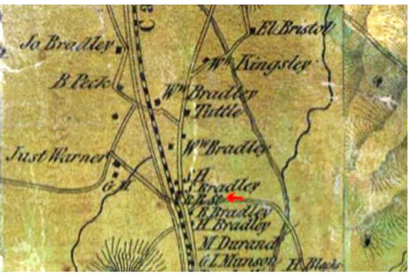
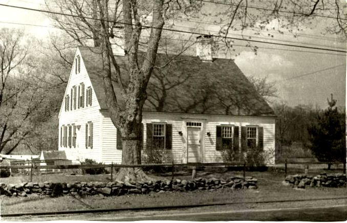
This Hamden stop appears on early Canal line timetables and the 1850 excursion poster at [4]. The probable location is seen on 1852NH map at [1] where our red arrow points to 'R.R.' and the Bradley surname is so much in evidence. According to the Hamden Historical Society, Amasa Bradley's house became a tavern with a basement taproom that served travelers on the canal as well as the railroad. The handsome structure pictured at [2] still stands on Whitney Ave. and River Rd., as seen on our CTTRAXMAP snippet at [4]. The bar room is reportedly still intact as well. [rev030518]
This Hamden stop appears on early Canal line timetables and the 1850 excursion poster at [4]. The probable location is seen on 1852NH map at [1] where our red arrow points to 'R.R.' and the Bradley surname is so much in evidence. According to the Hamden Historical Society, Amasa Bradley's house became a tavern with a basement taproom that served travelers on the canal as well as the railroad. The handsome structure pictured at [2] still stands on Whitney Ave. and River Rd., as seen on our CTTRAXMAP snippet at [4]. The bar room is reportedly still intact as well. [rev030518]
|
|

|

|
|

|
BRADLEYS/MIDDLEBURY [NY&NE, c1881; depot, 1885?]
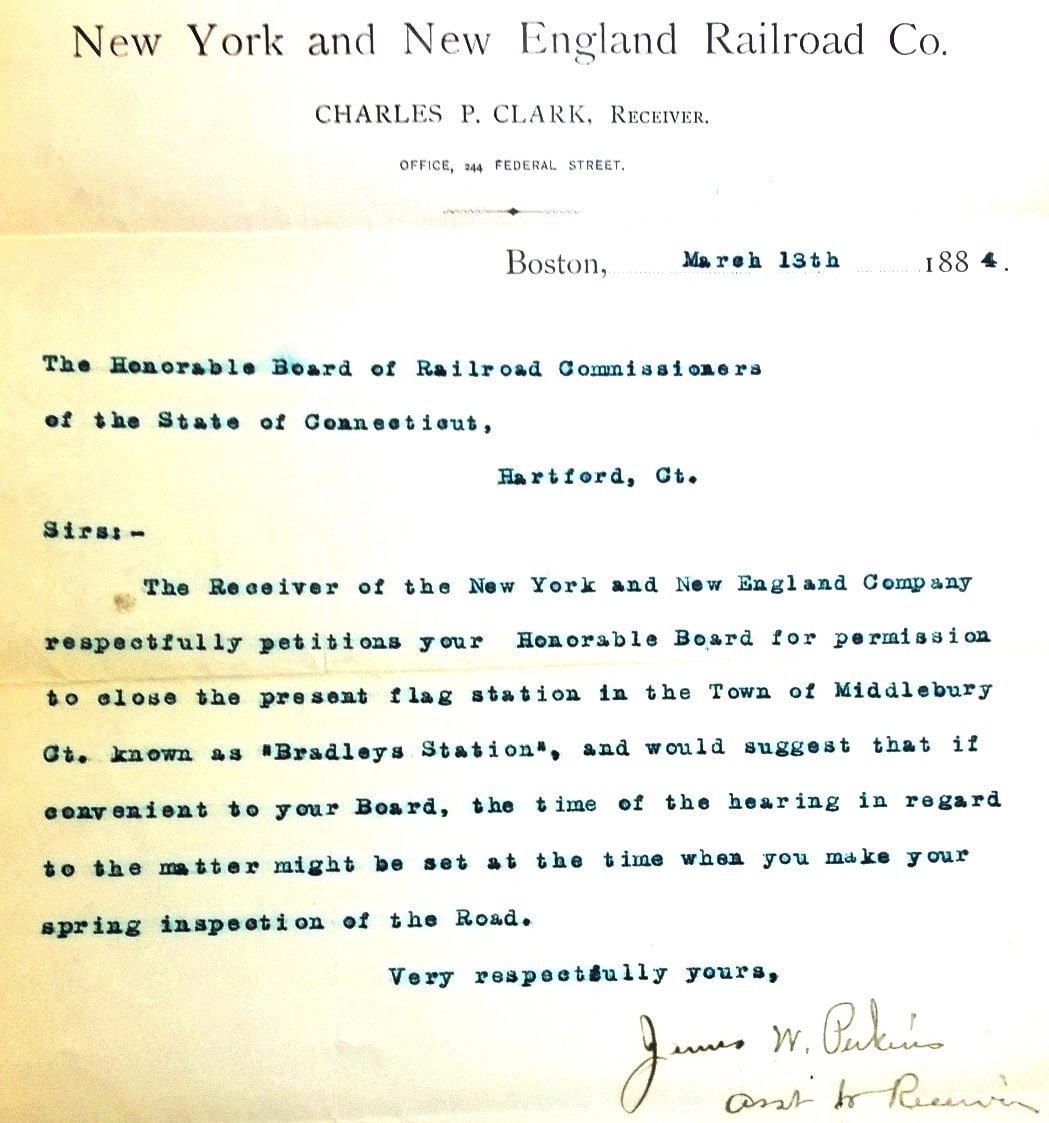
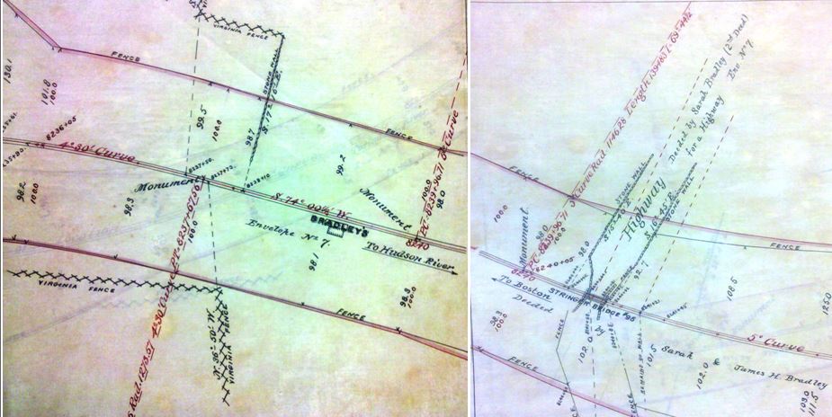
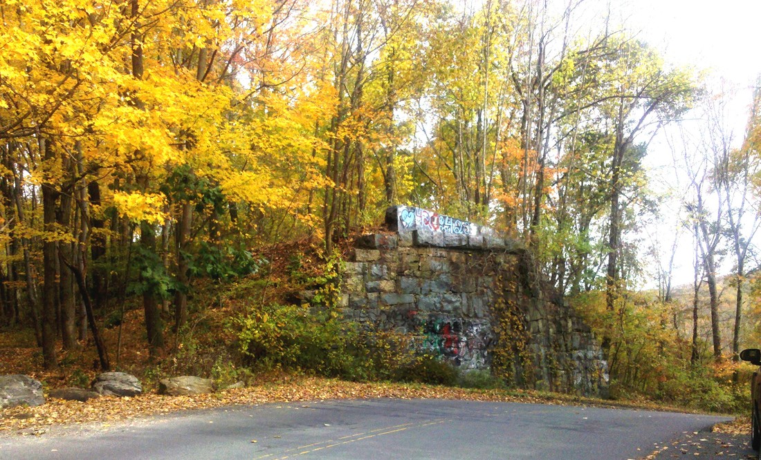
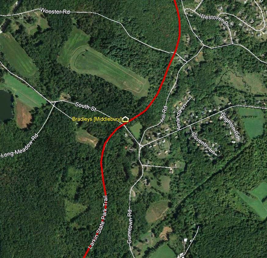
According to Rockey, this flag stop was established when the NY&NE opened through the town of Middlebury in 1881. Almost the first we hear of it is the 3/13/1884 letter at [1] sent by Charles P. Clark, then receiver for the already financially troubled NY&NE and later president of the triumphant NYNH&H, requesting permission to abandon this station. Though not important enough to merit official mention in 1881, BRADLEYS was in use long enough by 1884 and was sufficiently popular that public protest convinced the railroad commissioners to reject the request to eliminate it. A petition to the commissioners also requested that "... there be a Building to comfortably shelter People wishing to use said trains" here where apparently there had been no structure prior. By the time the 1886 real estate map at [2] was issued, a rectangular depot of perhaps 10x20 feet is seen with platform. The 1888TT at [3] is the only one we have seen so far that lists this stop. The location of the depot was just east of the South St undergrade bridge, as shown on the real estate map snippets we have pieced together. The 1893 map at [4] errs in showing the station just west of the highway on impossibly high terrain; the ROW was originally on trestle and later filled. The eastern bridge abutment still stands today and created a beautiful autumn scene at [5] on 10/18/2010. The newspaper reported a head-on collision of two freight trains at BRADLEYS on 3/12/1899, the aftermath seen at [6]. This was just prior to the permission to eliminate this stop by a special legislative act which also allowed the NYNH&H to discontinue UNION CITY/W in favor of a new station at OSBORNTOWN, subsequently renamed ALLERTON FARMS. Obscure flag stops, not always seen on timetables, were nonetheless protected by law if in use more than a year, requiring a hearing and permission by the commissioners for abandonment. The elimination of a station by the legislature is something we have not seen anywhere else and perhaps was due to the fact that two stations were being discontinued in favor of one at a completely new location. We have no photo and do not know the fate of whatever structure stood here. That it was not an agency station is proven by the lack of a role in the aforementioned collision in 1899 which took place just to the west between BRADLEYS and TOWANTIC. Our Track 11 Google Earth map at [7] pinpoints the location on South St. [REFS: RRC26.468 (5/15/1884); CRC32.1885.21; CWN/03/16/1899/03; HC/03/13/1899/01; NYT/03/13/1899/08; Conn. Spec. Law 405 (6/13/1899); R2.760][rev030818]
According to Rockey, this flag stop was established when the NY&NE opened through the town of Middlebury in 1881. Almost the first we hear of it is the 3/13/1884 letter at [1] sent by Charles P. Clark, then receiver for the already financially troubled NY&NE and later president of the triumphant NYNH&H, requesting permission to abandon this station. Though not important enough to merit official mention in 1881, BRADLEYS was in use long enough by 1884 and was sufficiently popular that public protest convinced the railroad commissioners to reject the request to eliminate it. A petition to the commissioners also requested that "... there be a Building to comfortably shelter People wishing to use said trains" here where apparently there had been no structure prior. By the time the 1886 real estate map at [2] was issued, a rectangular depot of perhaps 10x20 feet is seen with platform. The 1888TT at [3] is the only one we have seen so far that lists this stop. The location of the depot was just east of the South St undergrade bridge, as shown on the real estate map snippets we have pieced together. The 1893 map at [4] errs in showing the station just west of the highway on impossibly high terrain; the ROW was originally on trestle and later filled. The eastern bridge abutment still stands today and created a beautiful autumn scene at [5] on 10/18/2010. The newspaper reported a head-on collision of two freight trains at BRADLEYS on 3/12/1899, the aftermath seen at [6]. This was just prior to the permission to eliminate this stop by a special legislative act which also allowed the NYNH&H to discontinue UNION CITY/W in favor of a new station at OSBORNTOWN, subsequently renamed ALLERTON FARMS. Obscure flag stops, not always seen on timetables, were nonetheless protected by law if in use more than a year, requiring a hearing and permission by the commissioners for abandonment. The elimination of a station by the legislature is something we have not seen anywhere else and perhaps was due to the fact that two stations were being discontinued in favor of one at a completely new location. We have no photo and do not know the fate of whatever structure stood here. That it was not an agency station is proven by the lack of a role in the aforementioned collision in 1899 which took place just to the west between BRADLEYS and TOWANTIC. Our Track 11 Google Earth map at [7] pinpoints the location on South St. [REFS: RRC26.468 (5/15/1884); CRC32.1885.21; CWN/03/16/1899/03; HC/03/13/1899/01; NYT/03/13/1899/08; Conn. Spec. Law 405 (6/13/1899); R2.760][rev030818]

BRADLEYS/ORANGE [NH&D, 1871]
According to a Palladium article, this Orange stop, along with ALLINGS CROSSING, was discontinued when the TYLER CITY station debuted at a point midway between them on 6/1/1872. Created less than a year earlier when the NH&D opened, it is doubtful that any structure stood here on today's Racebrook Rd., just south of New Haven Ave. As shown on the 1912 NYNH&H real estate map, this thoroughfare was known earlier as Bradley Ave. for the family that owned the sprawling farm, much of which was sold for the creation of Tyler City itself. See Track 4B, MP 4.45.1 for more on this section of the NH&D right of way. [REFS: NHJC/11/20/1871/02; NHDP/06/06/872/04][rrd121816]
According to a Palladium article, this Orange stop, along with ALLINGS CROSSING, was discontinued when the TYLER CITY station debuted at a point midway between them on 6/1/1872. Created less than a year earlier when the NH&D opened, it is doubtful that any structure stood here on today's Racebrook Rd., just south of New Haven Ave. As shown on the 1912 NYNH&H real estate map, this thoroughfare was known earlier as Bradley Ave. for the family that owned the sprawling farm, much of which was sold for the creation of Tyler City itself. See Track 4B, MP 4.45.1 for more on this section of the NH&D right of way. [REFS: NHJC/11/20/1871/02; NHDP/06/06/872/04][rrd121816]

|
|

Dan Foley photo
|

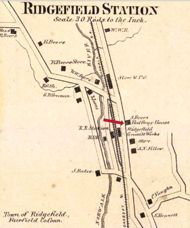
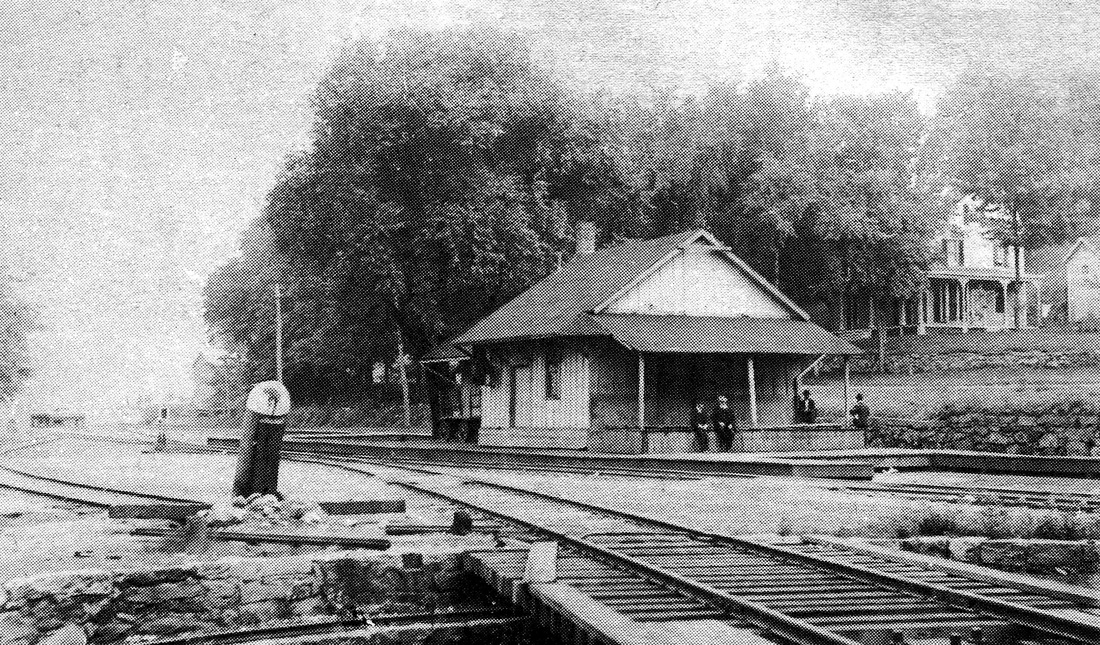
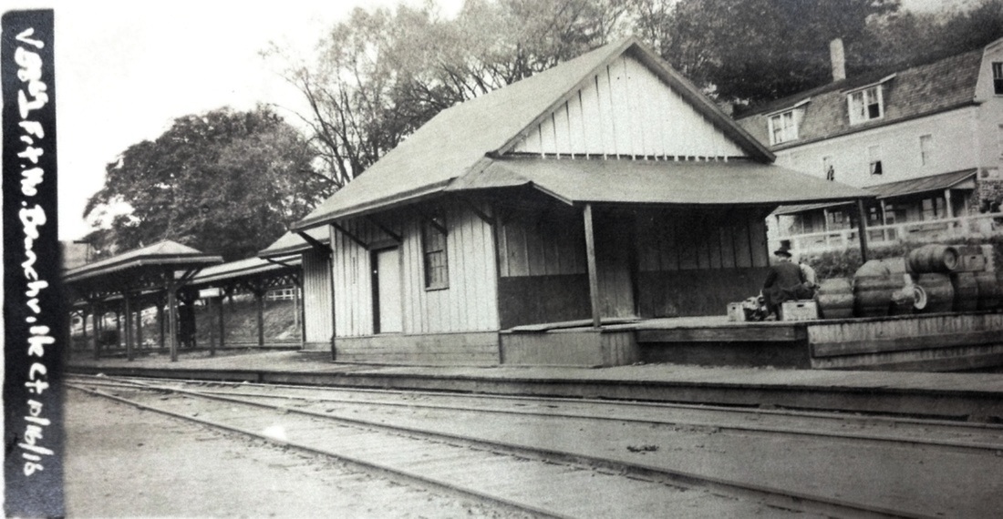
BRANCHVILLE1 [D&N, 1852; opens as RIDGEFIELD STATION]
The white house in the shot at [4] and seen in the background of the other photos was the first depot here in the town of Ridgefield. This stop was originally known as RIDGEFIELD STATION or BEERS STATION. Our red arrow shows the location, labeled Halfway House, on the inset from F.W. Beer's Fairfield County atlas, seen at [2]. This was on the D&N main line at the point that was to become known in 1870 as Branchville when the D&N's branch to the center of Ridgefield opened. Initially, the railroad intended to build a station here, but decided to rent space instead, a tact many early rail companies took to save money in their salad days. In the words of Sherman Beers, who had already made land available for the right of way, the lease was for "the front two rooms in the basement in the dwelling house now occupied by me, together with the room or office between the said front two rooms and now occupied as a bar room... for the uses and privileges of a passenger house and ticket office for said railroad company." On the Ridgefield "Then and Now" Facebook page, eminent local historian Jack Sanders, whom we met some years ago at the Ridgefield Press office, says that... "This was the home and inn of Sherman Beers, who called the place the “Halfway House.” The name probably reflected the fact that the inn was situated on the main highway that ran from Norwalk to Danbury, and was half way between those two cities. Thus, stage coaches could stop here so that travelers could take a break on their journey north or south." The postcard at [1] shows the Beers house on the rise in the background, as well as the 1905 station, BRANCHVILLE3. The Beers residence served as the first railroad station here until ca. 1890 when BRANCHVILLE2 was built. Our thanks to Brent Colley, who submitted this Beers material and other information, as well as Mike Grace who keeps us informed of local events. [REFS: HDC/06/20/1870/04; L????][rrd121816, rev062722]
The white house in the shot at [4] and seen in the background of the other photos was the first depot here in the town of Ridgefield. This stop was originally known as RIDGEFIELD STATION or BEERS STATION. Our red arrow shows the location, labeled Halfway House, on the inset from F.W. Beer's Fairfield County atlas, seen at [2]. This was on the D&N main line at the point that was to become known in 1870 as Branchville when the D&N's branch to the center of Ridgefield opened. Initially, the railroad intended to build a station here, but decided to rent space instead, a tact many early rail companies took to save money in their salad days. In the words of Sherman Beers, who had already made land available for the right of way, the lease was for "the front two rooms in the basement in the dwelling house now occupied by me, together with the room or office between the said front two rooms and now occupied as a bar room... for the uses and privileges of a passenger house and ticket office for said railroad company." On the Ridgefield "Then and Now" Facebook page, eminent local historian Jack Sanders, whom we met some years ago at the Ridgefield Press office, says that... "This was the home and inn of Sherman Beers, who called the place the “Halfway House.” The name probably reflected the fact that the inn was situated on the main highway that ran from Norwalk to Danbury, and was half way between those two cities. Thus, stage coaches could stop here so that travelers could take a break on their journey north or south." The postcard at [1] shows the Beers house on the rise in the background, as well as the 1905 station, BRANCHVILLE3. The Beers residence served as the first railroad station here until ca. 1890 when BRANCHVILLE2 was built. Our thanks to Brent Colley, who submitted this Beers material and other information, as well as Mike Grace who keeps us informed of local events. [REFS: HDC/06/20/1870/04; L????][rrd121816, rev062722]
|
|
|

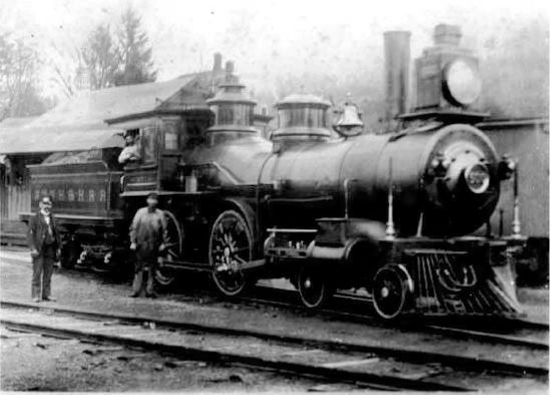
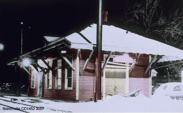
BRANCHVILLE2 [HRR, c1890]
This station was built by the HRR sometime between 1887 and 1890. The latter date is supplied by an article in the Connecticut Western News that says "... the Houstaonic railroad company are erecting a water tank of 90,000 gallons capacity near the Branchville depot on the Danbury & Norwalk division." While a this is a bit of a leap, we speculate that upgrades were in progress here at the time and may have included a new depot, which, in any case, was most likely built after the late 1886 lease of the D&N by the HRR. While we have found no newspaper announcement of the the debut of BRANCHVILLE2, when BRANCHVILLE3 was under construction in 1905, the Danbury News said that "... the frame work for the new passenger station at Branchville is now up and the the building will soon be erected. The old depot will be used for a freight station." The photos, except the Blizzard of 1888 southeastward shot at [4], look at this combination station from the southwest, with the passenger portion out of sight on the north end. Note the turntable and track-end bumper in the foreground in the shot at [1]. The view at [2] shows NYNH&H No. 500 re-lettered from NH&D No. 50, J.H. Bartholemew, which came to the HRR after its 1887 lease of the Derby road. Seen here, it is some time after the Consolidated lease of the HRR in June, 1892 and before it became NYNH&H No. 2041 in 1904. The ICC valuation photo at [3] is dated 10/16/1916 and shows BRANCHVILLE2 as the freight house and BRANCHVILLE1, the old Beers residence behind it. The coversheds extend southward down from BRANCHVILLE3, which is out of sight just to the north. The ICC shot of the 1890 tank at [4] is also dated 10/16/1915. [REFS: CWN/10/29/1890/04; DN/02/22/1905/11][rev040714, 062722]
This station was built by the HRR sometime between 1887 and 1890. The latter date is supplied by an article in the Connecticut Western News that says "... the Houstaonic railroad company are erecting a water tank of 90,000 gallons capacity near the Branchville depot on the Danbury & Norwalk division." While a this is a bit of a leap, we speculate that upgrades were in progress here at the time and may have included a new depot, which, in any case, was most likely built after the late 1886 lease of the D&N by the HRR. While we have found no newspaper announcement of the the debut of BRANCHVILLE2, when BRANCHVILLE3 was under construction in 1905, the Danbury News said that "... the frame work for the new passenger station at Branchville is now up and the the building will soon be erected. The old depot will be used for a freight station." The photos, except the Blizzard of 1888 southeastward shot at [4], look at this combination station from the southwest, with the passenger portion out of sight on the north end. Note the turntable and track-end bumper in the foreground in the shot at [1]. The view at [2] shows NYNH&H No. 500 re-lettered from NH&D No. 50, J.H. Bartholemew, which came to the HRR after its 1887 lease of the Derby road. Seen here, it is some time after the Consolidated lease of the HRR in June, 1892 and before it became NYNH&H No. 2041 in 1904. The ICC valuation photo at [3] is dated 10/16/1916 and shows BRANCHVILLE2 as the freight house and BRANCHVILLE1, the old Beers residence behind it. The coversheds extend southward down from BRANCHVILLE3, which is out of sight just to the north. The ICC shot of the 1890 tank at [4] is also dated 10/16/1915. [REFS: CWN/10/29/1890/04; DN/02/22/1905/11][rev040714, 062722]
|
Dave Peters Collection
|
|
|

Edward E. Blackman photo
|
Edward E. Blackman photo
|

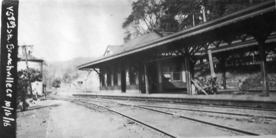
BRANCHVILLE3 [NYNH&H, 1905]
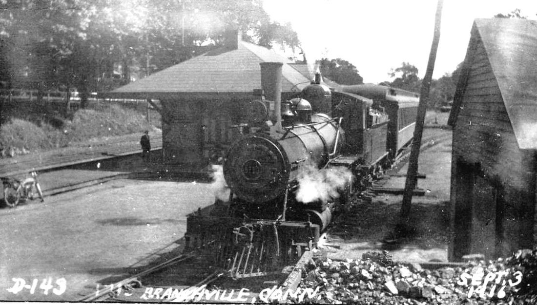
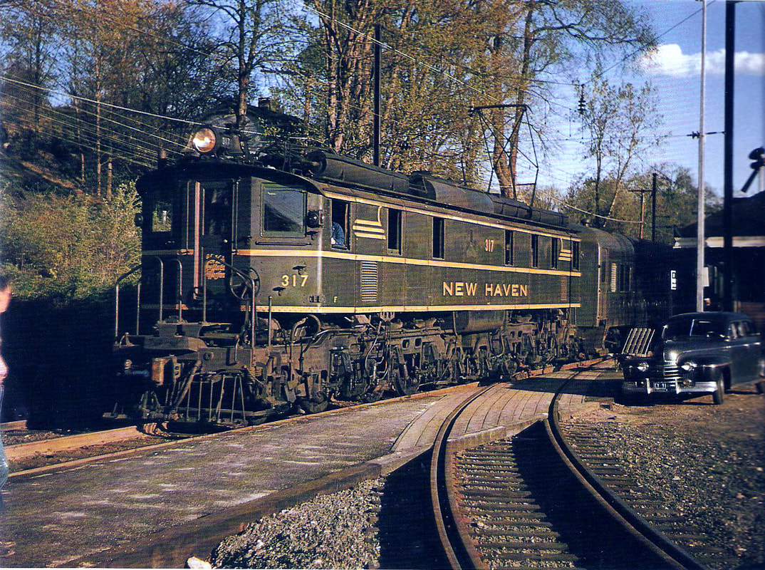
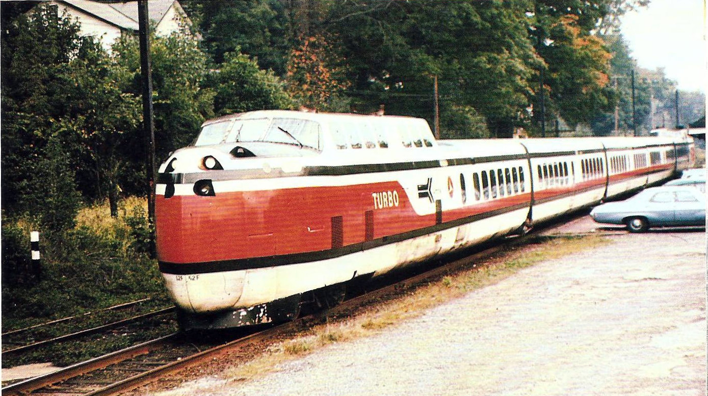
Due to a gap in the microfilm of the Ridgefield Press, we are unable to pinpoint the exact opening date of this station. An article in that paper in December, 1904 said that "the new railroad station at Branchville will be a wooden structure to cost about $8,000." In March, 1905, the paper read as follows: "The New Station. Work on the new railroad station at Branchville is progressing rapidly. The lumber for the new platforms has arrived and they will soon be laid. The station building has received its first coat of paint and the interior will soon be in order. By the time spring is really with us the building will no doubt be ready for the summer travel." Buzz in the Bee in April, 1905 said that ... the Branchville people feel quite proud over the fine new depot that has lately been erected in this place." The undated nighttime photo at [2] looks south. The valuation photo at [2] is dated 10/15/1916. The view at [3] shows NYNH&H No. 1715 taking the branch track with a Ridgefield train on 9/3/1916. The magnificent shot at [4] catches an EP-2 No. 317 departing for Danbury, sometime after the end of steam ca. 1952 when the initial '0' was dropped from the lettering. The view at [5] is from the Penn Central or Conrail era. Amtrak in Branchville? Once in a lifetime? The image at [6] shows the Turbotrain heading north on a detour via Danbury after the Norwalk drawbridge was damaged by tugboats. This was likely the New York-Boston train on 9/27/1972. The 1915 ICC valuation map at [7] shows the layout, the Ridgefield branch diverging from the Danbury main line. Note Bridgeport Wood Finishing and Monarch Mining companies located trackside here at the time to take advantage of railroad service. BRANCHVILLE3 still stands today in commercial use at the Metro North stop on the Danbury Line. [REFS: RP/12/01/1904/01; NBE/02/17/1905/05; RP/03/16/1905/05; NBE/04/14/1905/03; CRC53.1905.25; R36; HC/09/27/1972/01; L111; SL17.4.26; NHP, p519][rev123017, 062822, 031623]
Due to a gap in the microfilm of the Ridgefield Press, we are unable to pinpoint the exact opening date of this station. An article in that paper in December, 1904 said that "the new railroad station at Branchville will be a wooden structure to cost about $8,000." In March, 1905, the paper read as follows: "The New Station. Work on the new railroad station at Branchville is progressing rapidly. The lumber for the new platforms has arrived and they will soon be laid. The station building has received its first coat of paint and the interior will soon be in order. By the time spring is really with us the building will no doubt be ready for the summer travel." Buzz in the Bee in April, 1905 said that ... the Branchville people feel quite proud over the fine new depot that has lately been erected in this place." The undated nighttime photo at [2] looks south. The valuation photo at [2] is dated 10/15/1916. The view at [3] shows NYNH&H No. 1715 taking the branch track with a Ridgefield train on 9/3/1916. The magnificent shot at [4] catches an EP-2 No. 317 departing for Danbury, sometime after the end of steam ca. 1952 when the initial '0' was dropped from the lettering. The view at [5] is from the Penn Central or Conrail era. Amtrak in Branchville? Once in a lifetime? The image at [6] shows the Turbotrain heading north on a detour via Danbury after the Norwalk drawbridge was damaged by tugboats. This was likely the New York-Boston train on 9/27/1972. The 1915 ICC valuation map at [7] shows the layout, the Ridgefield branch diverging from the Danbury main line. Note Bridgeport Wood Finishing and Monarch Mining companies located trackside here at the time to take advantage of railroad service. BRANCHVILLE3 still stands today in commercial use at the Metro North stop on the Danbury Line. [REFS: RP/12/01/1904/01; NBE/02/17/1905/05; RP/03/16/1905/05; NBE/04/14/1905/03; CRC53.1905.25; R36; HC/09/27/1972/01; L111; SL17.4.26; NHP, p519][rev123017, 062822, 031623]
|
|
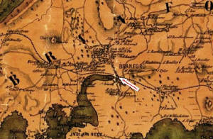
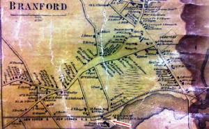
BRANFORD1 [NH&NL, 1852]
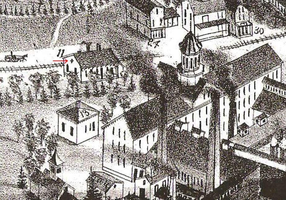
The 1852NH map at [1] already shows the NH&NL that opened in July of the very same year but does not yet indicate a station here. How reliable this is as an indicator is unclear but, in fact, this map does show a depot in place for MADISON and other towns. Rockey, on the other hand, states that "when the road was completed, in 1852, the station was located at the foot of Montowese street, where was also the village wharf." He continues on to say that "a few years later Elizur Rogers began his improvements at Page's Point, opening a new street to that place from Main street, in the old village, and the depot was soon after located west of Page Point wharf." The map at [2] dates to 1856 and shows the depot south of the track at the new location. Since the earlier map shows no depot, we are going out on a limb in thinking that the Andrews residence there at the foot of Montowese St. [red arrow] may have served as BRANFORD1 until an actual structure was built as BRANFORD2. Many thanks to Jane Bouley of the Branford Historical Society for the photos, maps, and data, much of which we have incorporated into this examination of the town's railroad stations. Would that we had such luck, assistance, and success everywhere! [REFS: K95; R2.26; rev111114, rrd121816]
The 1852NH map at [1] already shows the NH&NL that opened in July of the very same year but does not yet indicate a station here. How reliable this is as an indicator is unclear but, in fact, this map does show a depot in place for MADISON and other towns. Rockey, on the other hand, states that "when the road was completed, in 1852, the station was located at the foot of Montowese street, where was also the village wharf." He continues on to say that "a few years later Elizur Rogers began his improvements at Page's Point, opening a new street to that place from Main street, in the old village, and the depot was soon after located west of Page Point wharf." The map at [2] dates to 1856 and shows the depot south of the track at the new location. Since the earlier map shows no depot, we are going out on a limb in thinking that the Andrews residence there at the foot of Montowese St. [red arrow] may have served as BRANFORD1 until an actual structure was built as BRANFORD2. Many thanks to Jane Bouley of the Branford Historical Society for the photos, maps, and data, much of which we have incorporated into this examination of the town's railroad stations. Would that we had such luck, assistance, and success everywhere! [REFS: K95; R2.26; rev111114, rrd121816]
Branford Historical Society
|

Branford Historical Society
|
Branford Historical Society
|
Branford Historical Society
|
|
|
BRANFORD2 [NH&NL, 1854]
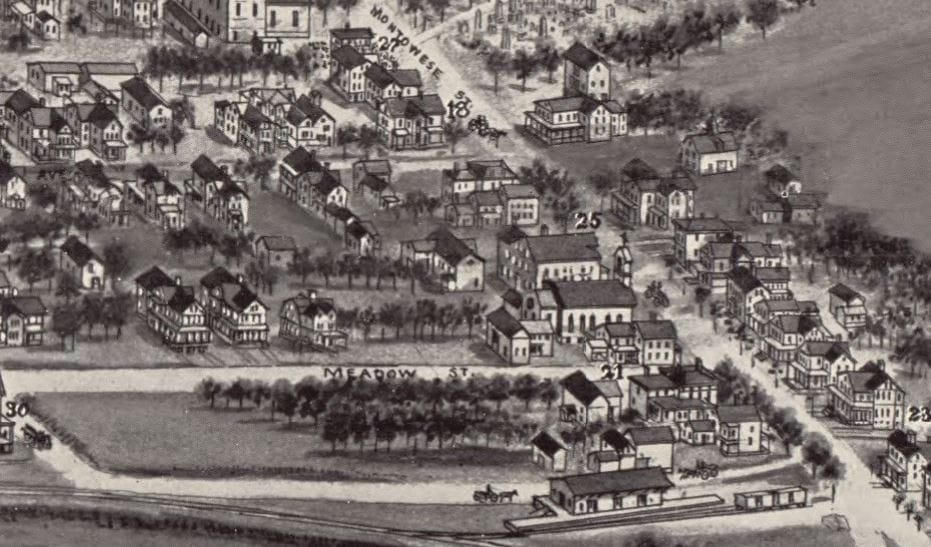
The earliest station that has survived in town images is seen in the the upper shots, [1] being an enlargement of [2]. The Columbian Register said in September, 1854 that "a new Station for Branford will be located at new Depot, a short distance west of the present Station, on the first day of November, 1854." The enduring 'compass' detail that the NYP&B put on the sides of the NH&NL depots it leased from 1858 to 1862, while not in sight in the photos, was caught when the bird's-eye map at [5] was sketched in 1881. Thank you, Mr. Bailey! An 1885 article in the Register anticipating the elegant brick BRANFORD3 said it would replace the "old brown wooden structure" and a 1939 article in The Branford Review said that this new one was built on the opposite side of the track, thus north, of the old one that stood on the south side. That location is verified on both the maps, the one at [4] being 1868. This station was may have been used briefly as a freight depot in this location before being razed or moved to allow the construction of the bridge that eliminated the Kirkham St. grade crossing just to the west. According to the railroad commissioners, however, a new freight depot was built in 1887, the one seen to the east at Montowese St. on the 1905 bird's-eye map at [6]. We think that the theory, advanced by Carr, that BRANFORD2 became the new freight station is unlikely, and only possible if both the structure was moved and the commissioners misspoke. [REFS: CR/09/17/1854/04; HDC/07/15/1863/02; NHER/08/24/1885/04; CRC36.1888.19; BR/08/ 17/1939/01; Carr, John C., Old Branford, p48][rev111114, 121816]
The earliest station that has survived in town images is seen in the the upper shots, [1] being an enlargement of [2]. The Columbian Register said in September, 1854 that "a new Station for Branford will be located at new Depot, a short distance west of the present Station, on the first day of November, 1854." The enduring 'compass' detail that the NYP&B put on the sides of the NH&NL depots it leased from 1858 to 1862, while not in sight in the photos, was caught when the bird's-eye map at [5] was sketched in 1881. Thank you, Mr. Bailey! An 1885 article in the Register anticipating the elegant brick BRANFORD3 said it would replace the "old brown wooden structure" and a 1939 article in The Branford Review said that this new one was built on the opposite side of the track, thus north, of the old one that stood on the south side. That location is verified on both the maps, the one at [4] being 1868. This station was may have been used briefly as a freight depot in this location before being razed or moved to allow the construction of the bridge that eliminated the Kirkham St. grade crossing just to the west. According to the railroad commissioners, however, a new freight depot was built in 1887, the one seen to the east at Montowese St. on the 1905 bird's-eye map at [6]. We think that the theory, advanced by Carr, that BRANFORD2 became the new freight station is unlikely, and only possible if both the structure was moved and the commissioners misspoke. [REFS: CR/09/17/1854/04; HDC/07/15/1863/02; NHER/08/24/1885/04; CRC36.1888.19; BR/08/ 17/1939/01; Carr, John C., Old Branford, p48][rev111114, 121816]

|
|
|
National Archives
|
|
|

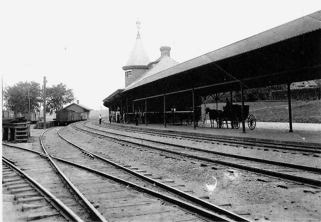
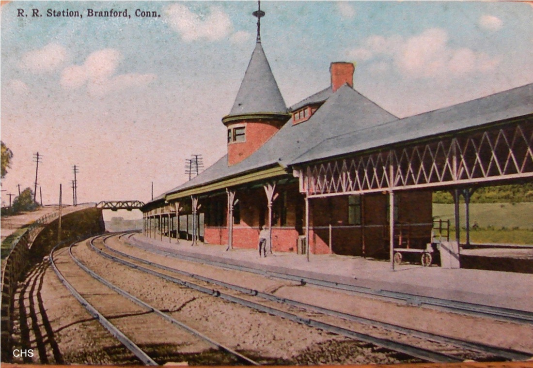
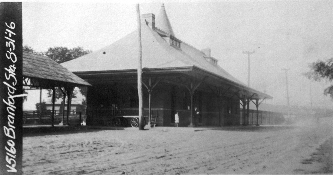
BRANFORD3 [NYNH&H, 1888]
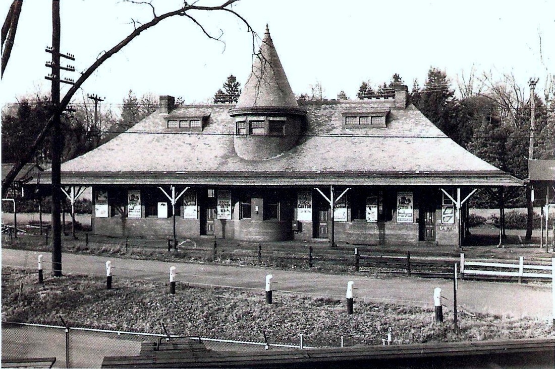
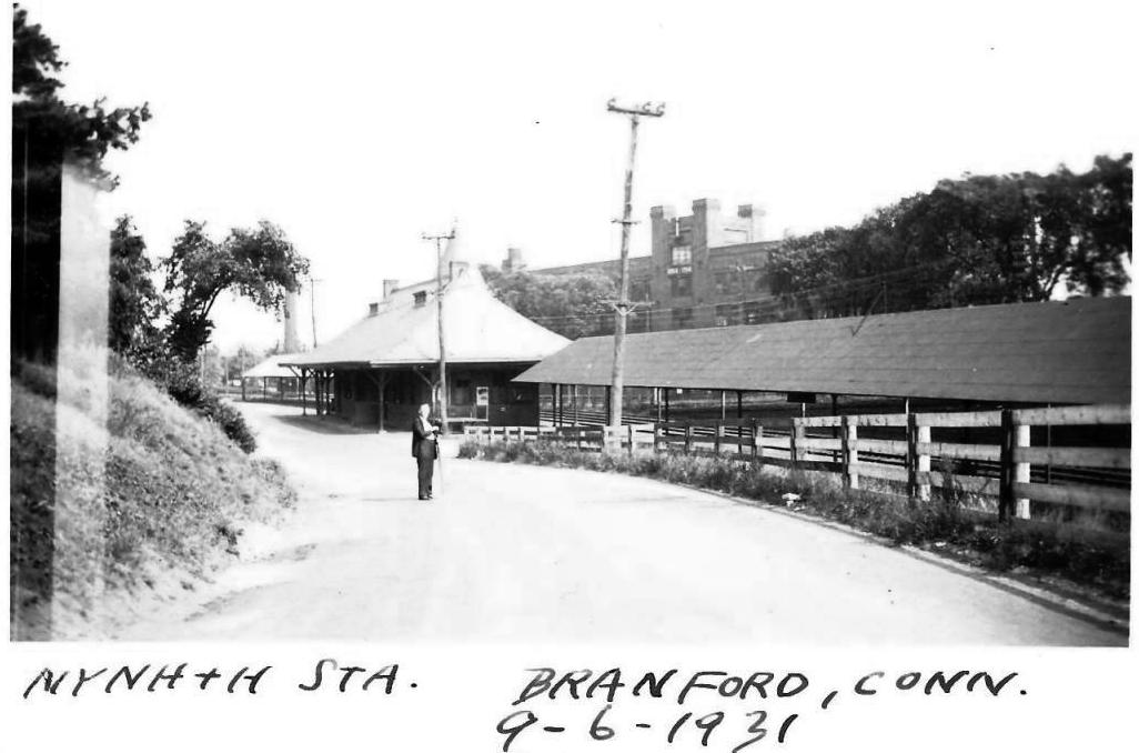
If the Consolidated had a more elegant and graceful station in Connecticut sitting on a sweeping curve to boot, we would be hard-pressed to find it. The architect's plan at [1] is dated October, 1886. In early November, 1887, a Register article reported that work was rapidly progressing on the new depot and another article late in the month said that it was likely not going to be opened until a grade crossing matter west of the station, Kirkham St., was resolved, making it sound like the structure was nearly ready then. Apparently with that matter settled, a tiny piece in the Register tells us that the formal opening of BRANFORD3 was on 6/28/1888. BRANFORD2 is seen in [2] probably in use as the freight station for a very brief time before it was removed. The image at [3] explains what happened to the old station. The approach to the bridge built to eliminate the Kirkham St. grade crossing, a contentious issue in town affairs for years, took the space where BRANFORD2 sat. Image [4] is an 8/31/1916 valuation photo of the street side of the station. Articles in the Branford News and The Branford Review have helped clarify the fate of the grand, turreted BRANFORD3. The latter says that it was "in urgent need of repairs" after damage from the 1938 hurricane and that contractors were bidding in August, 1939 on the demolition job since it was the railroad's intention "to wreck the station and erect in its stead a shelter, similar to the one at Leetes Island." The removal of BRANFORD3 was contemplated even earlier because only two trains per day were stopping here for New Haven commuters. The photo at [5] is likely from the 1930s with Eddie Cantor posters visible and roof repairs needed. The elderly gentleman with camera and tripod in the 9/6/1931 photo at [6] is Lewis Herbert Benton taken by Irving Newell Drake. Benton started taking photograph railroad stations in 1910, apparently with his bicycle transported on the trains he rode. In 1927 trips began with Drake; he and his automobile are usually seen in the subsequent photos. Benton took pictures of thousands of railroad stations all over New England until his death in 1939. Drake took his own photos in the 1930s and thereafter. The item at [7] is a chance find in the Branford Review and East Haven News, where the wrecking company is selling off the building materials on the station site in March, 1940. Makes you cringe to think of the desecration that was taking place! [REFS: NHER/08/24/1885/04; NHAR15.1885.11; NHER/11/02/1887/03; NHER/11/26/1887/03; CRC35.1887.17; NHAR16.1887.7; NHAR17.1888.7; CRC36.1888.19; NHER/02/25/1889 /01: bridge done; NHER/06/28/1892/01: case over; BR/08/17/1939/01; BN/08/20/1939/00 ; BREHN/03/21 /1940 /07; NL6.6.6; NL20.4.10][rev100516, 122818, 063022]
If the Consolidated had a more elegant and graceful station in Connecticut sitting on a sweeping curve to boot, we would be hard-pressed to find it. The architect's plan at [1] is dated October, 1886. In early November, 1887, a Register article reported that work was rapidly progressing on the new depot and another article late in the month said that it was likely not going to be opened until a grade crossing matter west of the station, Kirkham St., was resolved, making it sound like the structure was nearly ready then. Apparently with that matter settled, a tiny piece in the Register tells us that the formal opening of BRANFORD3 was on 6/28/1888. BRANFORD2 is seen in [2] probably in use as the freight station for a very brief time before it was removed. The image at [3] explains what happened to the old station. The approach to the bridge built to eliminate the Kirkham St. grade crossing, a contentious issue in town affairs for years, took the space where BRANFORD2 sat. Image [4] is an 8/31/1916 valuation photo of the street side of the station. Articles in the Branford News and The Branford Review have helped clarify the fate of the grand, turreted BRANFORD3. The latter says that it was "in urgent need of repairs" after damage from the 1938 hurricane and that contractors were bidding in August, 1939 on the demolition job since it was the railroad's intention "to wreck the station and erect in its stead a shelter, similar to the one at Leetes Island." The removal of BRANFORD3 was contemplated even earlier because only two trains per day were stopping here for New Haven commuters. The photo at [5] is likely from the 1930s with Eddie Cantor posters visible and roof repairs needed. The elderly gentleman with camera and tripod in the 9/6/1931 photo at [6] is Lewis Herbert Benton taken by Irving Newell Drake. Benton started taking photograph railroad stations in 1910, apparently with his bicycle transported on the trains he rode. In 1927 trips began with Drake; he and his automobile are usually seen in the subsequent photos. Benton took pictures of thousands of railroad stations all over New England until his death in 1939. Drake took his own photos in the 1930s and thereafter. The item at [7] is a chance find in the Branford Review and East Haven News, where the wrecking company is selling off the building materials on the station site in March, 1940. Makes you cringe to think of the desecration that was taking place! [REFS: NHER/08/24/1885/04; NHAR15.1885.11; NHER/11/02/1887/03; NHER/11/26/1887/03; CRC35.1887.17; NHAR16.1887.7; NHAR17.1888.7; CRC36.1888.19; NHER/02/25/1889 /01: bridge done; NHER/06/28/1892/01: case over; BR/08/17/1939/01; BN/08/20/1939/00 ; BREHN/03/21 /1940 /07; NL6.6.6; NL20.4.10][rev100516, 122818, 063022]
Branford Historical Society
|

|

|
Branford Historical Society
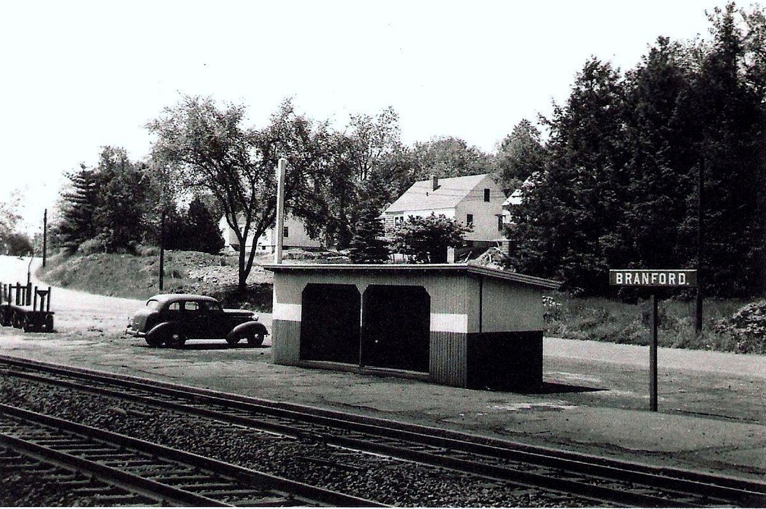
BRANFORD4 [NYNH&H, 1940]
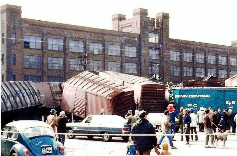
The grandeur, however faded, that was BRANFORD3 was replaced by a small wooden box. A brief article on the front page of the BREHN read on 3/21/1940: "New R.R. Depot. A small building is being erected next to the present Branford Railroad station. The New Haven Road decided some time ago to demolish the present structure , it having out lived [sic] its usefullness [sic] and being in need of repair." The photo at [1] was taken by Charlie Gunn in the mid-1950s and the aerial shot at [2] shows the outline from the sky in 1965. The dating of the image at [3] might be better judged by people more familiar with the variety of vintage automobiles but may be from the 1960s. BRANFORD4 met its own end when the Courant reported in 1970 that the "old Branford depot" was demolished by a Boston-New York freight train that derailed on 3/22/1970, with 25 of the 86 cars leaving the tracks that were torn up for a quarter of a mile. A boy who had just waved to the engineer heard the crash seconds later and said it "sounded like the end of the world." The aftermath is pictured at [4]. [REFS: HC/03/23/1970/02; BREHN/03/21/1940/01][rev111114, 122818]
The grandeur, however faded, that was BRANFORD3 was replaced by a small wooden box. A brief article on the front page of the BREHN read on 3/21/1940: "New R.R. Depot. A small building is being erected next to the present Branford Railroad station. The New Haven Road decided some time ago to demolish the present structure , it having out lived [sic] its usefullness [sic] and being in need of repair." The photo at [1] was taken by Charlie Gunn in the mid-1950s and the aerial shot at [2] shows the outline from the sky in 1965. The dating of the image at [3] might be better judged by people more familiar with the variety of vintage automobiles but may be from the 1960s. BRANFORD4 met its own end when the Courant reported in 1970 that the "old Branford depot" was demolished by a Boston-New York freight train that derailed on 3/22/1970, with 25 of the 86 cars leaving the tracks that were torn up for a quarter of a mile. A boy who had just waved to the engineer heard the crash seconds later and said it "sounded like the end of the world." The aftermath is pictured at [4]. [REFS: HC/03/23/1970/02; BREHN/03/21/1940/01][rev111114, 122818]
Branford Historical Society
BRANFORD5 [ATK, 1978/1979]
The estimated date of this photo is ca. 1979 and the folks at the Branford Historical Society say it was the next station here, this one on the south side of the tracks. This structure most likely came along with the creation of Amtrak when the revived Clamdigger stopped here from 1976 to 1978 and its successor Beacon Hill did the honors from 1978 to 1981. Notably this seems to have been the only Shore Line stop that saw a new structure from Amtrak. The track in the foreground is a spur to serve local industries. [click here and here]. [REFS: [rev111114, 051019]
The estimated date of this photo is ca. 1979 and the folks at the Branford Historical Society say it was the next station here, this one on the south side of the tracks. This structure most likely came along with the creation of Amtrak when the revived Clamdigger stopped here from 1976 to 1978 and its successor Beacon Hill did the honors from 1978 to 1981. Notably this seems to have been the only Shore Line stop that saw a new structure from Amtrak. The track in the foreground is a spur to serve local industries. [click here and here]. [REFS: [rev111114, 051019]
|
Branford Historical Society
|
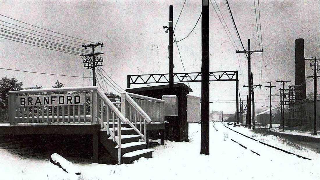
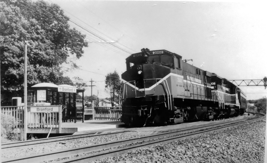
BRANFORD6 [SLE, c1990]
This platform with plexiglass enclosure stood once again on the north side of the tracks, the site of the preceding two stations. It debuted with the first incarnation of Shore Line East service in 1990. In August, 1991 P&W got trackage rights on the NEC and the photo at [1] shows one its trains passing the SLE shelter. The shot at [2] looks west toward the Kirkham St. overpass. [rev121816, 042619]
This platform with plexiglass enclosure stood once again on the north side of the tracks, the site of the preceding two stations. It debuted with the first incarnation of Shore Line East service in 1990. In August, 1991 P&W got trackage rights on the NEC and the photo at [1] shows one its trains passing the SLE shelter. The shot at [2] looks west toward the Kirkham St. overpass. [rev121816, 042619]

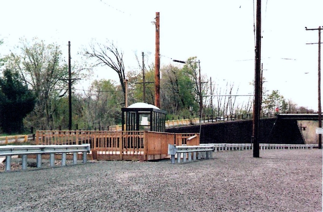
BRANFORD7 [SLE, 2005]
According to Wikipedia, this Shore Line East station opened on 8/8/2005. Our photo was taken on 8/2/2010. The station now is west of the Kirkham St. bridge that caused so much controversy a century ago. [rrd121816]
According to Wikipedia, this Shore Line East station opened on 8/8/2005. Our photo was taken on 8/2/2010. The station now is west of the Kirkham St. bridge that caused so much controversy a century ago. [rrd121816]
Branford Historical Society
|
|
|
Max Miller Collection
|
|
 Branford Historical Society
BRANFORD DRIVING PARK [BDPRR, 1901]
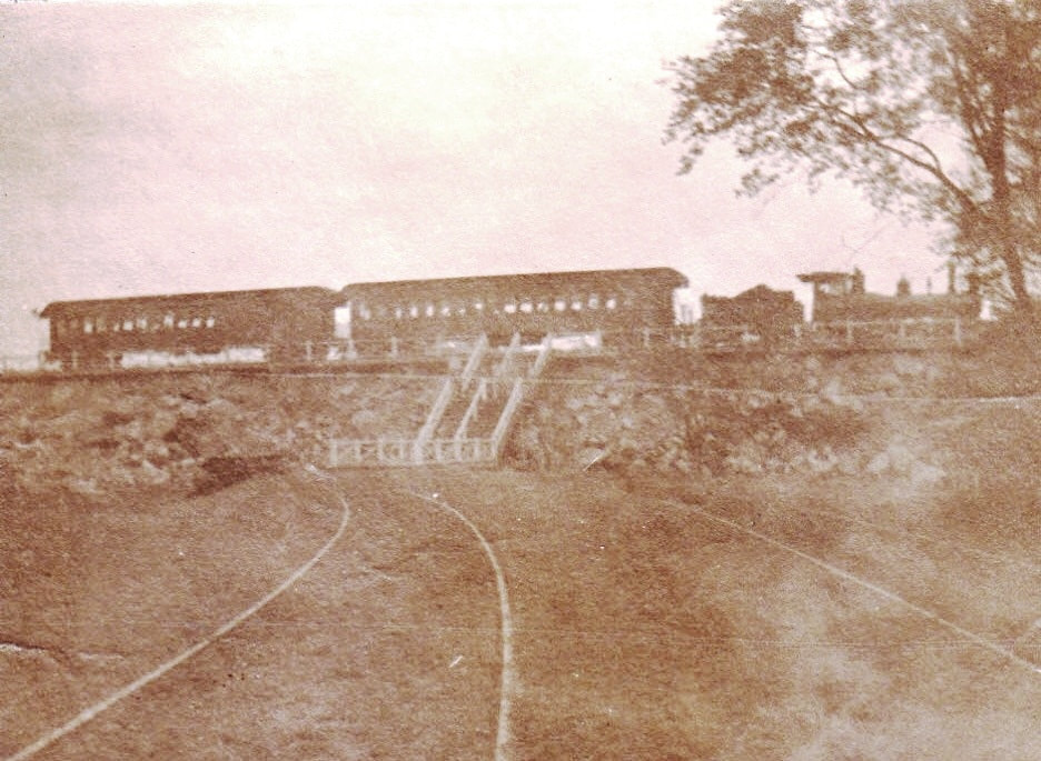
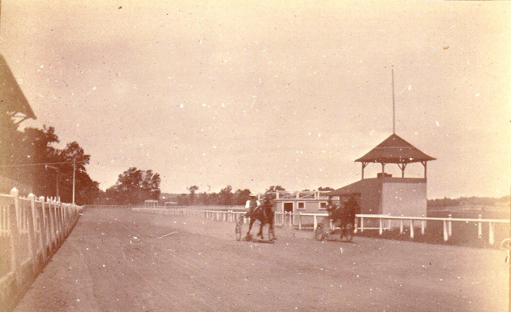
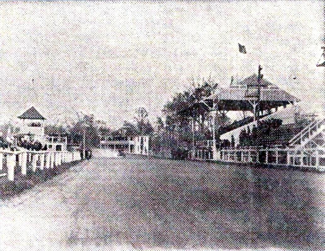
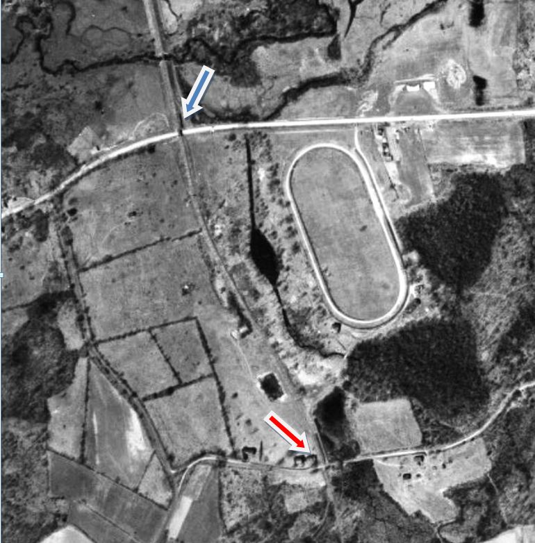
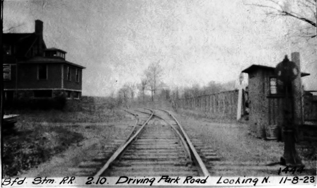
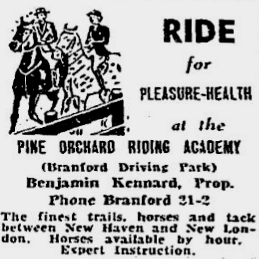
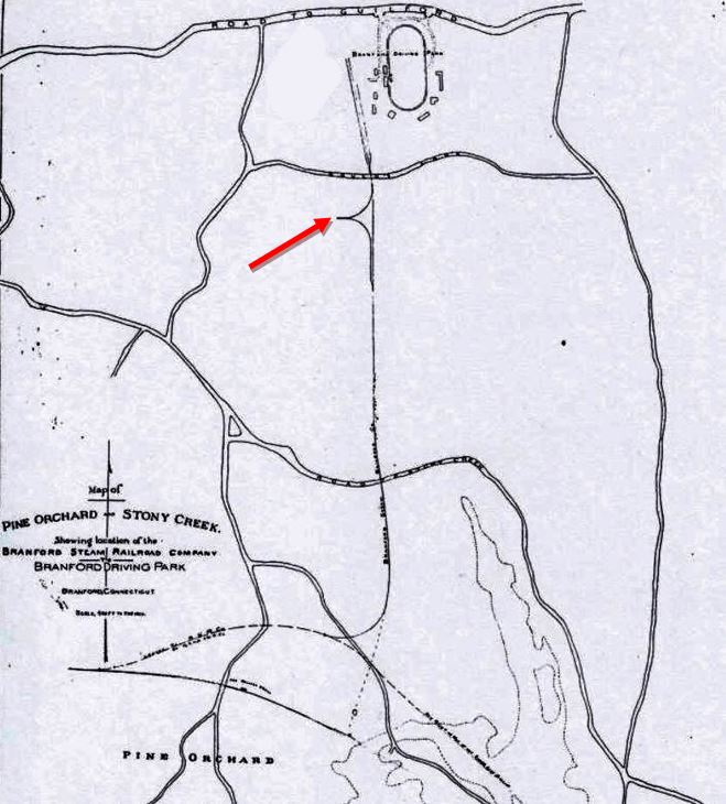
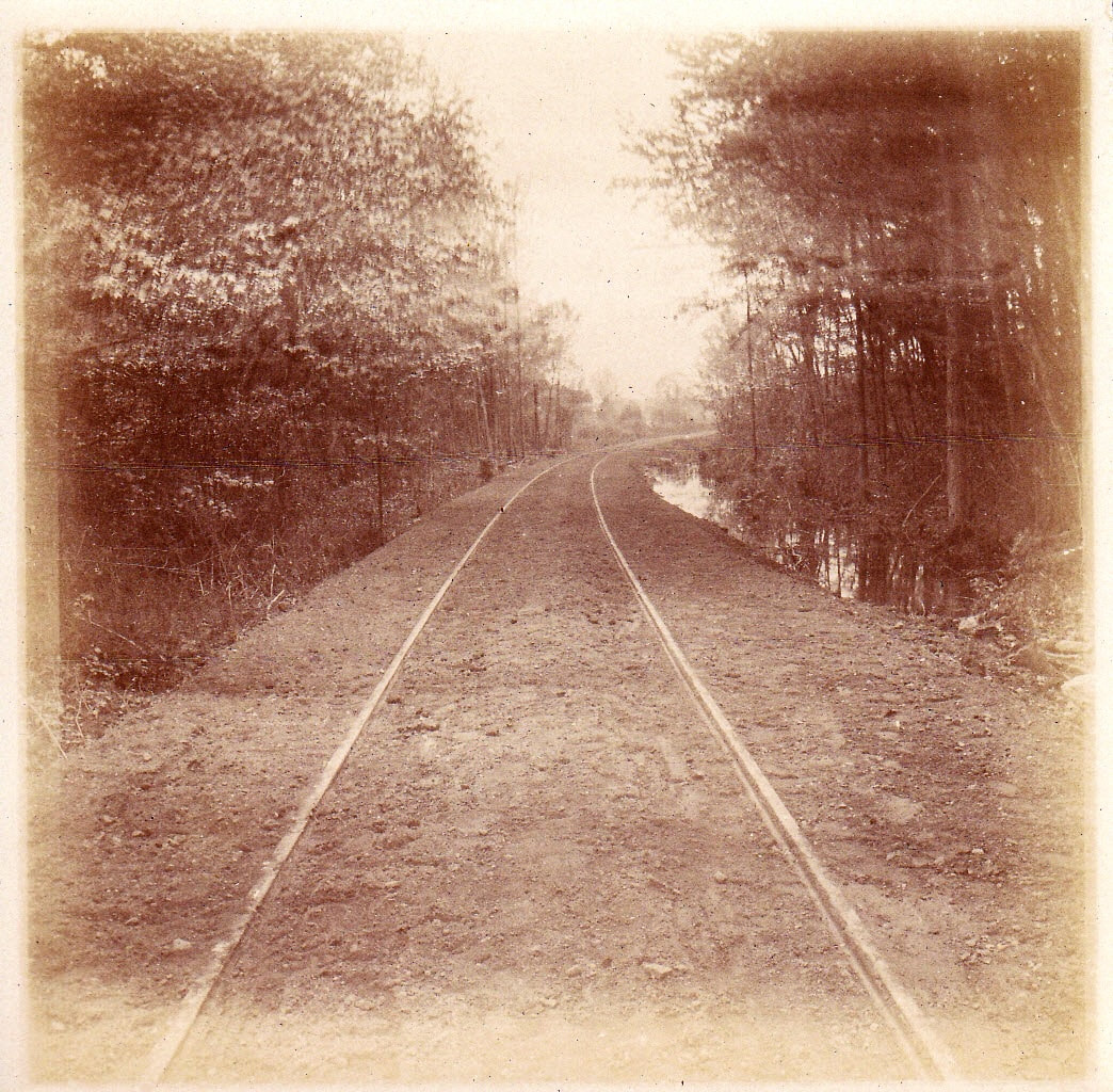
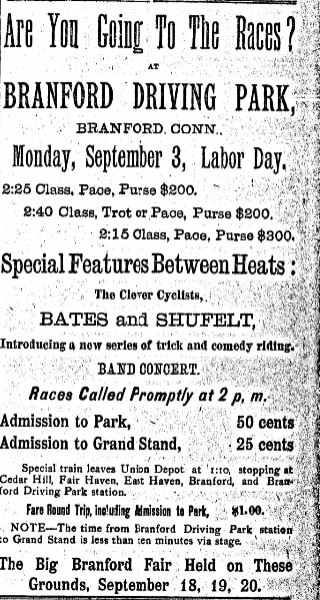
It is perhaps a little-known fact that the Branford Steam RR began as a spur track to a horse-racing and agricultural fair venue. The Branford Park Association was chartered in 1895 and the property was subsequently purchased by manager Louis Agassiz Fisk in 1900. Through his agency Branford Park Special trains initially brought passengers from New Haven Union Station to either BRANFORD3 or PINE ORCHARD2 and they were conveyed from there on existing roads. At [1] is one of several rare photos rescued from an estate sale on behalf of the Branford Historical Society. It shows a two-coach NYNH&H train at the platform that served as the park station when steam service started late in 1904; lower tracks in the foreground must have served the freight needs of the park. Our red arrow on the map at [7] shows the wye where trains were turned. Another of these photos at [2] shows trotters on the track. The shot at [3] is a newspaper photo showing the grandstands ca. 1909. By 1905 the P.T. Barnum-like impressario was illuminating his park with arc lamps, search lights, and mirror reflectors and promising a day and night "hippodrome" of trotting meets, bicycle racing, auto heats, vaudeville shows and airship fly-overs. Additionally the irrepressible Fisk was Branford's first selectman, state representative and had interests in Bridgeport and Waterbury racing venues; the L.A. Fisk Hose Company commemorates his name today in firefighting for the town. The 1934 aerial map at [4] shows the race track still very much intact. The red arrow points to Driving Park Rd., today's Gould Lane, seen in the 11/8/1923 PUC inspection photo at [5]. The blue arrow points to the railroad bridge over the Boston Post Road. Racing ended around 1912 but the annual Branford Fair continued at this venue. The final newspaper reference we see is at [6] in 1940 when Ben Kennard was running the property as the Pine Orchard Riding Academy. [REFS: Below][rev051019]
It is perhaps a little-known fact that the Branford Steam RR began as a spur track to a horse-racing and agricultural fair venue. The Branford Park Association was chartered in 1895 and the property was subsequently purchased by manager Louis Agassiz Fisk in 1900. Through his agency Branford Park Special trains initially brought passengers from New Haven Union Station to either BRANFORD3 or PINE ORCHARD2 and they were conveyed from there on existing roads. At [1] is one of several rare photos rescued from an estate sale on behalf of the Branford Historical Society. It shows a two-coach NYNH&H train at the platform that served as the park station when steam service started late in 1904; lower tracks in the foreground must have served the freight needs of the park. Our red arrow on the map at [7] shows the wye where trains were turned. Another of these photos at [2] shows trotters on the track. The shot at [3] is a newspaper photo showing the grandstands ca. 1909. By 1905 the P.T. Barnum-like impressario was illuminating his park with arc lamps, search lights, and mirror reflectors and promising a day and night "hippodrome" of trotting meets, bicycle racing, auto heats, vaudeville shows and airship fly-overs. Additionally the irrepressible Fisk was Branford's first selectman, state representative and had interests in Bridgeport and Waterbury racing venues; the L.A. Fisk Hose Company commemorates his name today in firefighting for the town. The 1934 aerial map at [4] shows the race track still very much intact. The red arrow points to Driving Park Rd., today's Gould Lane, seen in the 11/8/1923 PUC inspection photo at [5]. The blue arrow points to the railroad bridge over the Boston Post Road. Racing ended around 1912 but the annual Branford Fair continued at this venue. The final newspaper reference we see is at [6] in 1940 when Ben Kennard was running the property as the Pine Orchard Riding Academy. [REFS: Below][rev051019]
|

Branford Historical Society
|
Branford Historical Society
|
|
BRANFORD DRIVING PARK JUNCTION [BDPRR, 1901]
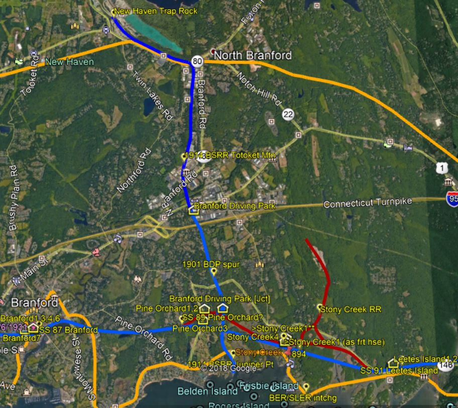
The irrepressible Mr. Fisk, however, wanted direct train service to the park and work on a stage road north to the park from the old NH&NL line was begun on 7/10/1900 and completed by 8/16/1900. We see the first mention of the BRANFORD DRIVING PARK station on 8/10/1900 when the paper reported that "special trains will stop at the new station at Pine Orchard and 'buses will convey passengers" from there. Other later articles describe the depot as "a trim little station just beyond Pine Orchard," and having platforms. Passengers from Saybrook could also access this station, the implication being that the entire trackage from STONY CREEK to PINE ORCHARD, abandoned as main line with the 1892 Shore Line realignment, was still retained for quarry service. Fisk would later purchase all of the cut-off for his purposes. Cooperating with him to get passenger use out of this trackage put money into the pockets of both the NYNH&H and his box office. Sorting through discrepancies in the reporting, it seems that tracks on the stage road were completed on 5/4/1901 and on 7/3/1901 "patrons found a string of horse cars" waiting to take them north on the BDP railroad spur. The cars were described as "very neat and pretty and lettered for "Branford Driving Park" [Oh, that we could find a photo of them!]. The Branford Steam RR was incorporated on 3/19/1903 by Fisk and two partners to take over the spur and permission to haul "property and passengers" by steam. The BSRR name was chosen to differentiate it from the Branford Electric Rwy that had opened on 9/3/1900. Since the spur was to be utilized only for park events, locally controversial grade crossings were allowed at a time when railroads were being required to eliminate them elsewhere. A connection with the park spur was made with the NYNH&H in 1904 and trains from as far as New York and Boston started running directly to the park. We have no photo of this station and do not know its the fate when passenger service likely ceased with the end of racing ca. 1912. The 1915 val map at [1] shows the western part of the old NH&NL ROW still in place to access the BSRR spur. The historical photos at [2] and [3] presumably are northward shots showing the ROW going up from the junction. The snippet at [4] is from our Track 11 Google Earth map and shows all the locations. The newspaper ad at [5] is from the New Haven Journal Courier of 9/1/1900. [REFS: NHER/04/01/1895/01; NHER/08/04/1899/08; NHER/08/31/1899/02; NHER/05/25/1900/09; HC/05/26/1900/02; NHER/05/30/1900/15; NHER/07/10/1900/08; NHER/07/21/1900/09; HC/07/26/1900/02; NHER/07/24/1900/02; NHER/07/26/1900/05; NYT/07/26/1900/05; NHER/08/10/1900/10; NHJC/08/14/1900/09; NHER/08/17/1900/10; NHER/08/31/1900/02: says track done and all-rail service to begin next Monday, without change of cars??; BOP/03/30/1901/06; NHER/09/04/1900/08; NHER/09/12/1900/09; CRC48.1900. 22; NHJC/05/08/1901/07; NHJC/06/29/1901/10; NHJC/07/04/1901/04; HC/09/04/1901/09; NHJC/09/11/1901/03; HC/12/28/1901/05; NHJC/12/30/1901/06: side track for switching at BDP jct; RRC37.485 (12/31/1901); NHER/04/29/1902/00; BOP/05/24/1902/06: nine extra horse cars; HC/12/31/1902/04; HC/01/23/1903/13; Spec. Law 1903-31; HC/12/28/1904/02; BRE/07/05/1928/01; HC/08/04/1933/07; HC/07/25/1937/D7; HC/07/13/1940 /SM13][rev121816, 122918, 050619]
The irrepressible Mr. Fisk, however, wanted direct train service to the park and work on a stage road north to the park from the old NH&NL line was begun on 7/10/1900 and completed by 8/16/1900. We see the first mention of the BRANFORD DRIVING PARK station on 8/10/1900 when the paper reported that "special trains will stop at the new station at Pine Orchard and 'buses will convey passengers" from there. Other later articles describe the depot as "a trim little station just beyond Pine Orchard," and having platforms. Passengers from Saybrook could also access this station, the implication being that the entire trackage from STONY CREEK to PINE ORCHARD, abandoned as main line with the 1892 Shore Line realignment, was still retained for quarry service. Fisk would later purchase all of the cut-off for his purposes. Cooperating with him to get passenger use out of this trackage put money into the pockets of both the NYNH&H and his box office. Sorting through discrepancies in the reporting, it seems that tracks on the stage road were completed on 5/4/1901 and on 7/3/1901 "patrons found a string of horse cars" waiting to take them north on the BDP railroad spur. The cars were described as "very neat and pretty and lettered for "Branford Driving Park" [Oh, that we could find a photo of them!]. The Branford Steam RR was incorporated on 3/19/1903 by Fisk and two partners to take over the spur and permission to haul "property and passengers" by steam. The BSRR name was chosen to differentiate it from the Branford Electric Rwy that had opened on 9/3/1900. Since the spur was to be utilized only for park events, locally controversial grade crossings were allowed at a time when railroads were being required to eliminate them elsewhere. A connection with the park spur was made with the NYNH&H in 1904 and trains from as far as New York and Boston started running directly to the park. We have no photo of this station and do not know its the fate when passenger service likely ceased with the end of racing ca. 1912. The 1915 val map at [1] shows the western part of the old NH&NL ROW still in place to access the BSRR spur. The historical photos at [2] and [3] presumably are northward shots showing the ROW going up from the junction. The snippet at [4] is from our Track 11 Google Earth map and shows all the locations. The newspaper ad at [5] is from the New Haven Journal Courier of 9/1/1900. [REFS: NHER/04/01/1895/01; NHER/08/04/1899/08; NHER/08/31/1899/02; NHER/05/25/1900/09; HC/05/26/1900/02; NHER/05/30/1900/15; NHER/07/10/1900/08; NHER/07/21/1900/09; HC/07/26/1900/02; NHER/07/24/1900/02; NHER/07/26/1900/05; NYT/07/26/1900/05; NHER/08/10/1900/10; NHJC/08/14/1900/09; NHER/08/17/1900/10; NHER/08/31/1900/02: says track done and all-rail service to begin next Monday, without change of cars??; BOP/03/30/1901/06; NHER/09/04/1900/08; NHER/09/12/1900/09; CRC48.1900. 22; NHJC/05/08/1901/07; NHJC/06/29/1901/10; NHJC/07/04/1901/04; HC/09/04/1901/09; NHJC/09/11/1901/03; HC/12/28/1901/05; NHJC/12/30/1901/06: side track for switching at BDP jct; RRC37.485 (12/31/1901); NHER/04/29/1902/00; BOP/05/24/1902/06: nine extra horse cars; HC/12/31/1902/04; HC/01/23/1903/13; Spec. Law 1903-31; HC/12/28/1904/02; BRE/07/05/1928/01; HC/08/04/1933/07; HC/07/25/1937/D7; HC/07/13/1940 /SM13][rev121816, 122918, 050619]
|
|

|
|
|

|
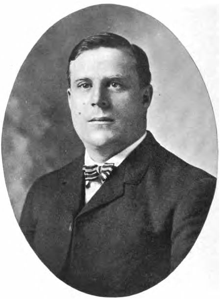
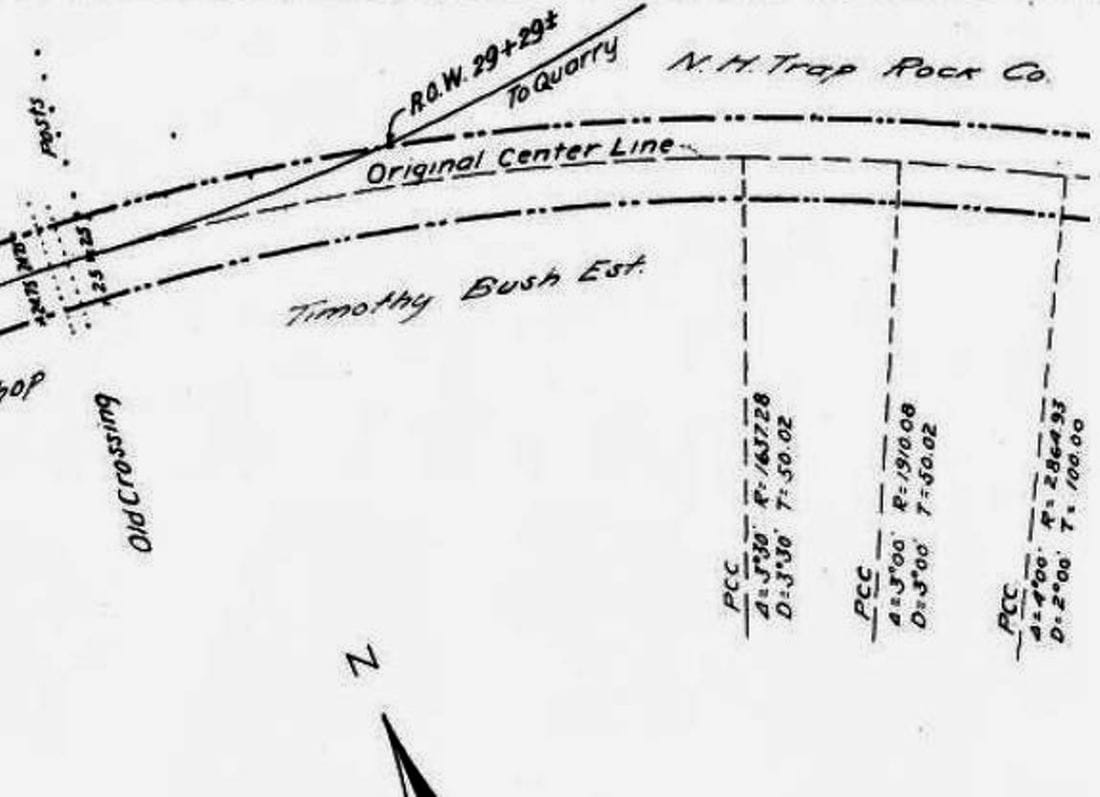
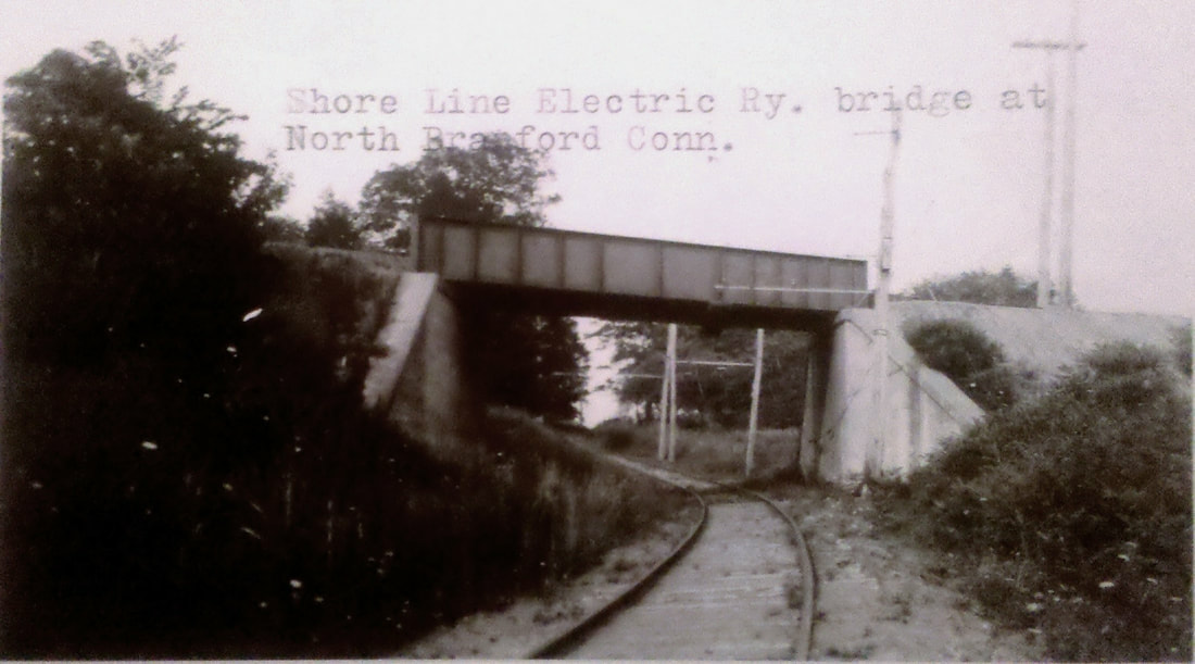
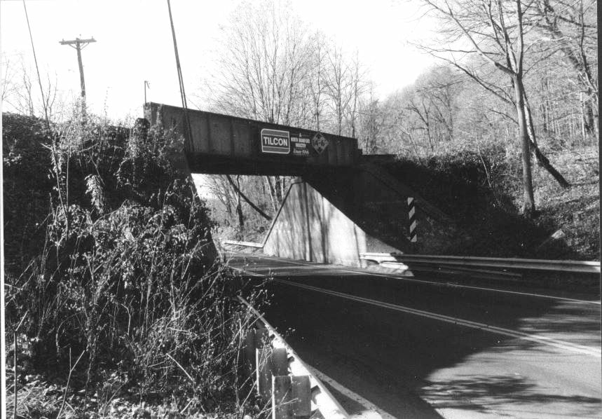
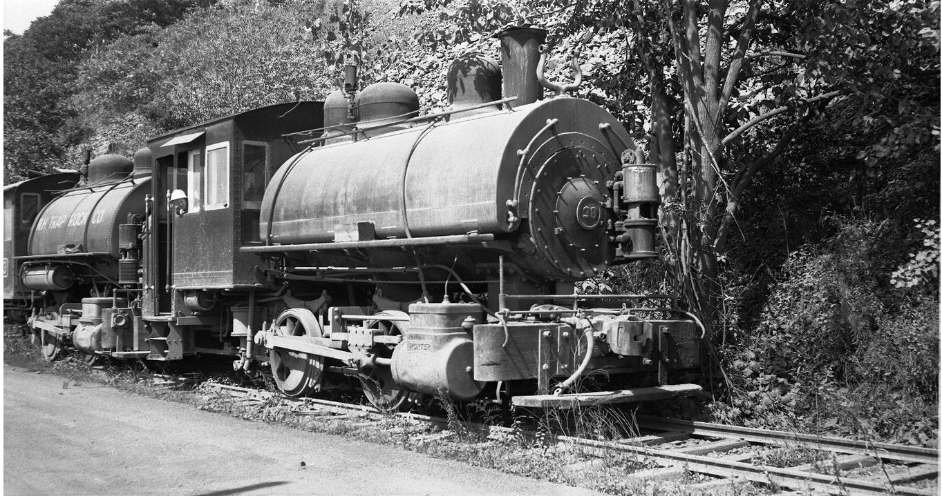
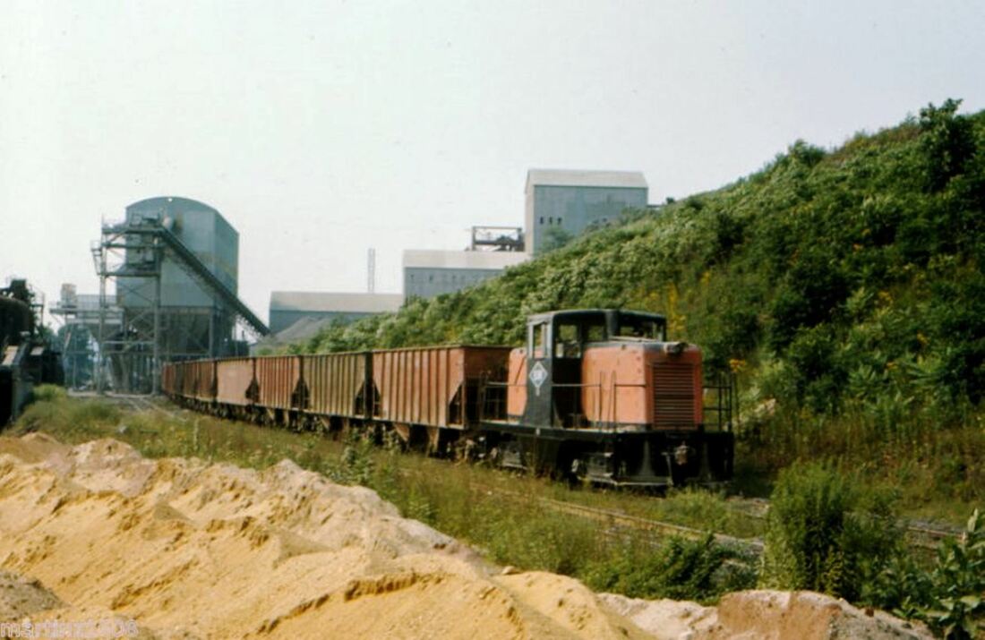
Concurrent to the development of the park, the energetic Fisk [at left] became interested in quarrying trap rock on Totoket Mountain in North Branford and he was granted permission in 1905 for an extension dubbed the Damascus RR for this section of Branford; this new entity was later folded into the BSRR. Through his influence as a state legislator, he was able to get permission for the DRR crossings, with the exception of the Boston Post Road, to be at grade, with the general assembly even overriding a gubernatorial veto to allow one at heavily traveled Rte. 80. This coup, incidentally, forced the Shore Line Electric Rwy, about to open in 1911, to lower its gradient and construct the bridge seen at [1] to go under the still-unbuilt BSRR; steam and electric roads intersecting at grade was forbidden by state law. While further permission to build to a tidewater terminus at Juniper Point was received in 1909, the newspaper said as late as 1910 that no BSRR construction on either end had begun. It is unclear why Fisk exited but he sold both the quarry and the BSRR in 1914 to his partners, principal of whom were members of the Blakeslee construction family. They completed the line under the corporate name of the New Haven Trap Rock Co. Interestingly, when Rte 80 was paved with "bituminous macadam" in 1933, it was realigned to use the old SLER underpass. The state replaced the 1914 bridge seen at [1] with a new one in 1955 as seen at [2], and with a wider span in 2006 as seen at [3]. BSRR #38 is on the point at [4] with an 0-4-0 behind it on 1/3/1958. Dieselization came in 1962. At [5] BSRR center-cab locomotive pulls train of cars at quarry in 1985; the BSRR diamond logo is on the side of the cab. The March, 2015 shot at [6] shows the BSRR heading north at Pleasant Point Rd in Pine Orchard; interchange with NEC is behind the photographer. The raft of citations above and below may be the most extensive compilation to date on the fascinating Fisk, the park, and the BSRR [click here]; we have even more! With its peculiar origins, special privileges, and unique evolution, this railroad went, in just the first 15 years of its existence, from personal horse-car rail spur, to steam operation, to common-carrier as a private industrial railroad and still operates today over a century later. [REFS: Photo: Taylor's Legislative History of Connecticut, 1903-1904; RRC9.106 (9/24/1904); HC/05/29/1905/02; HC/06/16/1905/11; Spec. Law 1905-481; HC/05/28/1906/17; HC/06/04/1907/07; HC/07/02/1910/07: trolley permission but electric cars never ran; Spec. Law, 1907-236; Spec. Law 1909-104; HC/03/05/1909/06; HC/03/29/1910/06; HC/02/11/1911/06; HC/04/05/1910/11; RRC13.40-51,52 (6/30/1910); HC/07/02/1910/07; CRC58.1910.9; CRC59.1911.44+; HC/02/28/1911/05; PUC1.1912.lv; HC/06/20/1912/07; HC/06/26/1912/05; HC/02/07/1914/04; HC/04/28/1914/12; PUC3.1914.36; NLD/05/06/1915/11; MDJ/05/12/1915/03; Spec. Law 1915 -343; BRE/07/21/1955/03; NHR/05/26/1963/4/01; NHR/07/26/1987/B5; NHR/12/31/ 2005/B2; H421; R2.35][rev121816, 122918, 051019]
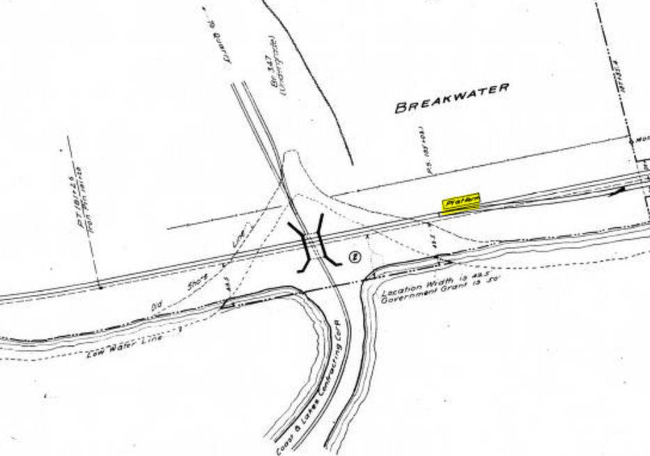
BREAKWATER [NYNH&H, c1900?]
As seen on the 1915 val map, this station in the town of Ledyard is on the N&W Groton extension, completed by the NYNH&H in 1899. [rev123114, rrd121816]
As seen on the 1915 val map, this station in the town of Ledyard is on the N&W Groton extension, completed by the NYNH&H in 1899. [rev123114, rrd121816]

BRICK YARD [NYNH&H, c1900?]
This stop is in the town of South Windsor. The 1915 val map shows just a platform here on the east side of the track and adjacent to the East Windsor Brick Co. This was not an original station on the Connecticut Central when it opened in 1876 and we do not yet know precisely when it was established, but it is on our 1907TT as a flag stop for one of the two trains daily each way between Hartford and Springfield on this branch. [rev071615, rrd121816]
This stop is in the town of South Windsor. The 1915 val map shows just a platform here on the east side of the track and adjacent to the East Windsor Brick Co. This was not an original station on the Connecticut Central when it opened in 1876 and we do not yet know precisely when it was established, but it is on our 1907TT as a flag stop for one of the two trains daily each way between Hartford and Springfield on this branch. [rev071615, rrd121816]

|
|
|
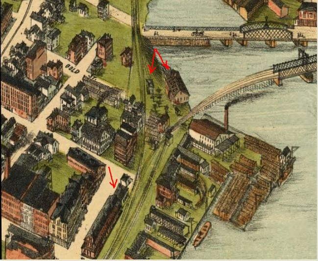
BRIDGEPORT1 [HRR, 1840]
According to Orcutt, the HRR opened "... commencing at a point near the west approach to the Bridgeport bridge -- Fairfield avenue -- it extended northerly across the mud flats over [the] Porter property... secured the entre point east of its main line... located their engine house, turn-tables and car-shop thereon..." The Sidney & Neff map at [1] is dated 1850; the upper red arrow points to the HRR facilities at Porter Point, identified by Orcutt as the location of Samuel Porter's farm at the foot of Gold St. The lower arrow points to where the track first commenced at Fairfield Ave. and was extended south to the steamboat dock in 1841. Fairfield County Historical Society records [click here] say that "... about 1846 the Housatonic Railroad company removed their depot for both for passenger and freight from near Fairfield avenue southerly to a point near the present elevator." Snippets [2] and [3] are from the Bailey 1875 bird's-eye map [click here]. The Porter farm location is seen in the former. The right shaft of the double arrow points to what FCHS calls the "long car house" that remained here for years after 1846 and the left shaft points to a small structure that we have discounted as being the first depot because it is too small and a bit too far from Fairfield Ave. The single red arrow on both snippets points to what we think was the first HRR depot, shown just north of the 1861 station, BRIDGEPORT3. Late in 1860, when that station was about to open, the Courant referred to the old one as a "shanty" and in 1879, the Journal Courier reported that "the old passenger depot of the Housatonic railroad in Bridgeport is being torn down." While both may refer to the larger BRIDGEPORT2, it is perhaps more likely that this small structure is the one they meant, possibly being used by the NY&NH after the HRR vacated it and in later days for a baggage and express office for all three railroads. It is worth noting that Mr. Bailey has once again come to the rescue with a representation of Bridgeport that we may never have had otherwise and that includes an accurate rendering of the 1848 swing-span bridge, the first of the four that the railroad would use to cross the Pequonnock River, as well as the Park City's old Congress St. bridge to the north. [REFS: BR/06/21/1841/103; HDC/12/29/1860/02; NHJC/08/12/1879/02; FCHS Reports and Papers, 1882-1897, p152,154 (Porter: see p6,7); Samuel Orcutt, A History of the Old Town of Stratford and the City of Bridgeport, Connecticut, 1886, 1.499,553][rev030115, rrd121816]
According to Orcutt, the HRR opened "... commencing at a point near the west approach to the Bridgeport bridge -- Fairfield avenue -- it extended northerly across the mud flats over [the] Porter property... secured the entre point east of its main line... located their engine house, turn-tables and car-shop thereon..." The Sidney & Neff map at [1] is dated 1850; the upper red arrow points to the HRR facilities at Porter Point, identified by Orcutt as the location of Samuel Porter's farm at the foot of Gold St. The lower arrow points to where the track first commenced at Fairfield Ave. and was extended south to the steamboat dock in 1841. Fairfield County Historical Society records [click here] say that "... about 1846 the Housatonic Railroad company removed their depot for both for passenger and freight from near Fairfield avenue southerly to a point near the present elevator." Snippets [2] and [3] are from the Bailey 1875 bird's-eye map [click here]. The Porter farm location is seen in the former. The right shaft of the double arrow points to what FCHS calls the "long car house" that remained here for years after 1846 and the left shaft points to a small structure that we have discounted as being the first depot because it is too small and a bit too far from Fairfield Ave. The single red arrow on both snippets points to what we think was the first HRR depot, shown just north of the 1861 station, BRIDGEPORT3. Late in 1860, when that station was about to open, the Courant referred to the old one as a "shanty" and in 1879, the Journal Courier reported that "the old passenger depot of the Housatonic railroad in Bridgeport is being torn down." While both may refer to the larger BRIDGEPORT2, it is perhaps more likely that this small structure is the one they meant, possibly being used by the NY&NH after the HRR vacated it and in later days for a baggage and express office for all three railroads. It is worth noting that Mr. Bailey has once again come to the rescue with a representation of Bridgeport that we may never have had otherwise and that includes an accurate rendering of the 1848 swing-span bridge, the first of the four that the railroad would use to cross the Pequonnock River, as well as the Park City's old Congress St. bridge to the north. [REFS: BR/06/21/1841/103; HDC/12/29/1860/02; NHJC/08/12/1879/02; FCHS Reports and Papers, 1882-1897, p152,154 (Porter: see p6,7); Samuel Orcutt, A History of the Old Town of Stratford and the City of Bridgeport, Connecticut, 1886, 1.499,553][rev030115, rrd121816]
|
|

|
|

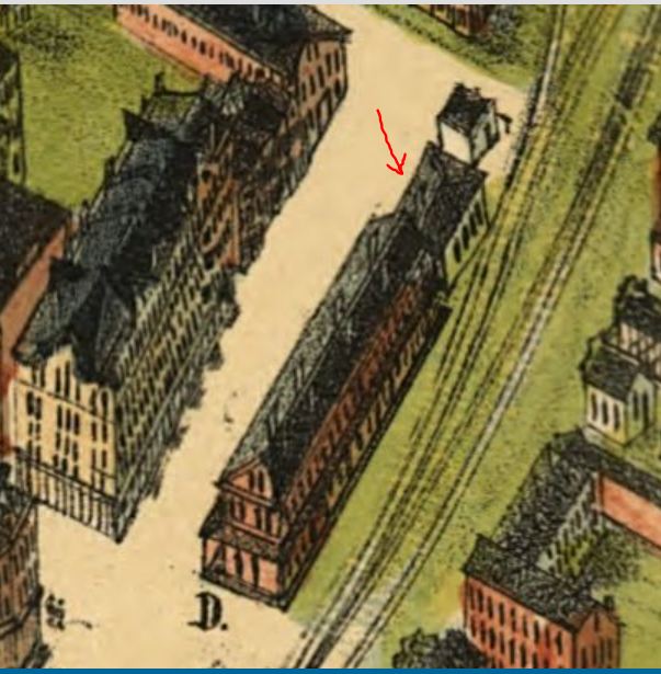
BRIDGEPORT2 [HRR, 1846]
The FCHS clue that the HRR moved its depot south to the grain elevator location ties nicely into the 1850 Sidney & Neff map at [1] and the 1856FC map at [2]. They both show an L-shaped depot at Water and Union Sts. on the east side of the tracks that now terminate there instead of at Porter Point. This second station would also be used by the NY&NH and the NRR when they both opened in 1848-1849. The HRR's 1850 annual report says that the rents the other two roads were paying were "proportionate to the occupancy" of the HRR terminal property and amounted half the interest on the cost of the facilities and indicating a 25/25/50 split. The 1867 Beers map at [3] shows the 1846 BRIDGEPORT2 location at the bottom red arrow and the 1861 BRIDGEPORT3 depot at the upper red arrow. A Courant article in 1865 mentions that HRR employee, William McGrath, was severely injured while working at "the old depot," which we interpret as meaning here. Though we have yet found no photographs, the shot from the 1875 Bailey bird's-eye map at [4] shows the appearance of a rather ornate building at the lower red arrow, standing right below the tall structure marked 'F', which is the grain elevator. Newspapers in 1846 noted the new construction and applauded the strides the HRR made after its early financial troubles. The Albany Evening Journal said that the company "have erected spacious Depot Buildings at their termination in Bridgeport" and the Palladium, quoted in the Republican Farmer, reported that the company "was erecting, at the lower end of the wharf a depot, which in its dimensions will equal, if not surpass, any structure of the kind in the country." Harlow's 1850 Bridgeport image at [5] seems to be overly stylized and not representative of the actual Bridgeport waterfront and skyline but does capture the spirit of the times. According to FCHS records, when Pres. Lincoln visited in March, 1860, "he arrived at the old depot, then at the foot of Union street" and we know he later gave a speech at what is now McLevy Hall a few blocks away. He was probably the last visitor of importance to this station because BRIDGEPORT3 would open less than a year later. BRIDGEPORT2, the lower portion at least, was later turned into a car house and the footprint presents such an appearance on the 1867 Beers map at [3] with tracks leading into it. An 1880 map shows HRR offices here, probably on the north end of the building but by 1884 the structure is gone and the space filled in with more tracks leading to expanded HRR facilities just to the south. [REFS: RF/09/15/1846/03; AEJ/11/21/1846/02; HRRAR1850.11,12; HDC/10/20/1865/02; BST/07/12/1869/04: old depot at 55 Water St.; NHJC/08/12/1879 /02; FCHS p1050, (see Lincoln, p. xvi); Harlow, Steelways of New England, opp. p82][rev030115, rrd121816]
The FCHS clue that the HRR moved its depot south to the grain elevator location ties nicely into the 1850 Sidney & Neff map at [1] and the 1856FC map at [2]. They both show an L-shaped depot at Water and Union Sts. on the east side of the tracks that now terminate there instead of at Porter Point. This second station would also be used by the NY&NH and the NRR when they both opened in 1848-1849. The HRR's 1850 annual report says that the rents the other two roads were paying were "proportionate to the occupancy" of the HRR terminal property and amounted half the interest on the cost of the facilities and indicating a 25/25/50 split. The 1867 Beers map at [3] shows the 1846 BRIDGEPORT2 location at the bottom red arrow and the 1861 BRIDGEPORT3 depot at the upper red arrow. A Courant article in 1865 mentions that HRR employee, William McGrath, was severely injured while working at "the old depot," which we interpret as meaning here. Though we have yet found no photographs, the shot from the 1875 Bailey bird's-eye map at [4] shows the appearance of a rather ornate building at the lower red arrow, standing right below the tall structure marked 'F', which is the grain elevator. Newspapers in 1846 noted the new construction and applauded the strides the HRR made after its early financial troubles. The Albany Evening Journal said that the company "have erected spacious Depot Buildings at their termination in Bridgeport" and the Palladium, quoted in the Republican Farmer, reported that the company "was erecting, at the lower end of the wharf a depot, which in its dimensions will equal, if not surpass, any structure of the kind in the country." Harlow's 1850 Bridgeport image at [5] seems to be overly stylized and not representative of the actual Bridgeport waterfront and skyline but does capture the spirit of the times. According to FCHS records, when Pres. Lincoln visited in March, 1860, "he arrived at the old depot, then at the foot of Union street" and we know he later gave a speech at what is now McLevy Hall a few blocks away. He was probably the last visitor of importance to this station because BRIDGEPORT3 would open less than a year later. BRIDGEPORT2, the lower portion at least, was later turned into a car house and the footprint presents such an appearance on the 1867 Beers map at [3] with tracks leading into it. An 1880 map shows HRR offices here, probably on the north end of the building but by 1884 the structure is gone and the space filled in with more tracks leading to expanded HRR facilities just to the south. [REFS: RF/09/15/1846/03; AEJ/11/21/1846/02; HRRAR1850.11,12; HDC/10/20/1865/02; BST/07/12/1869/04: old depot at 55 Water St.; NHJC/08/12/1879 /02; FCHS p1050, (see Lincoln, p. xvi); Harlow, Steelways of New England, opp. p82][rev030115, rrd121816]

|
|
|
|
|
|
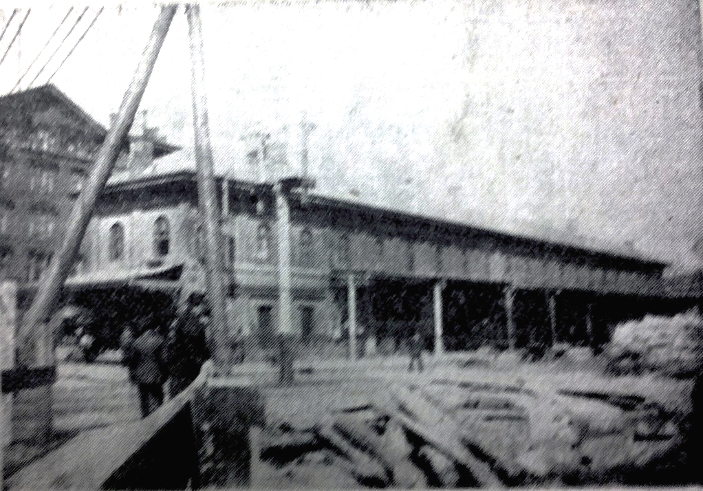
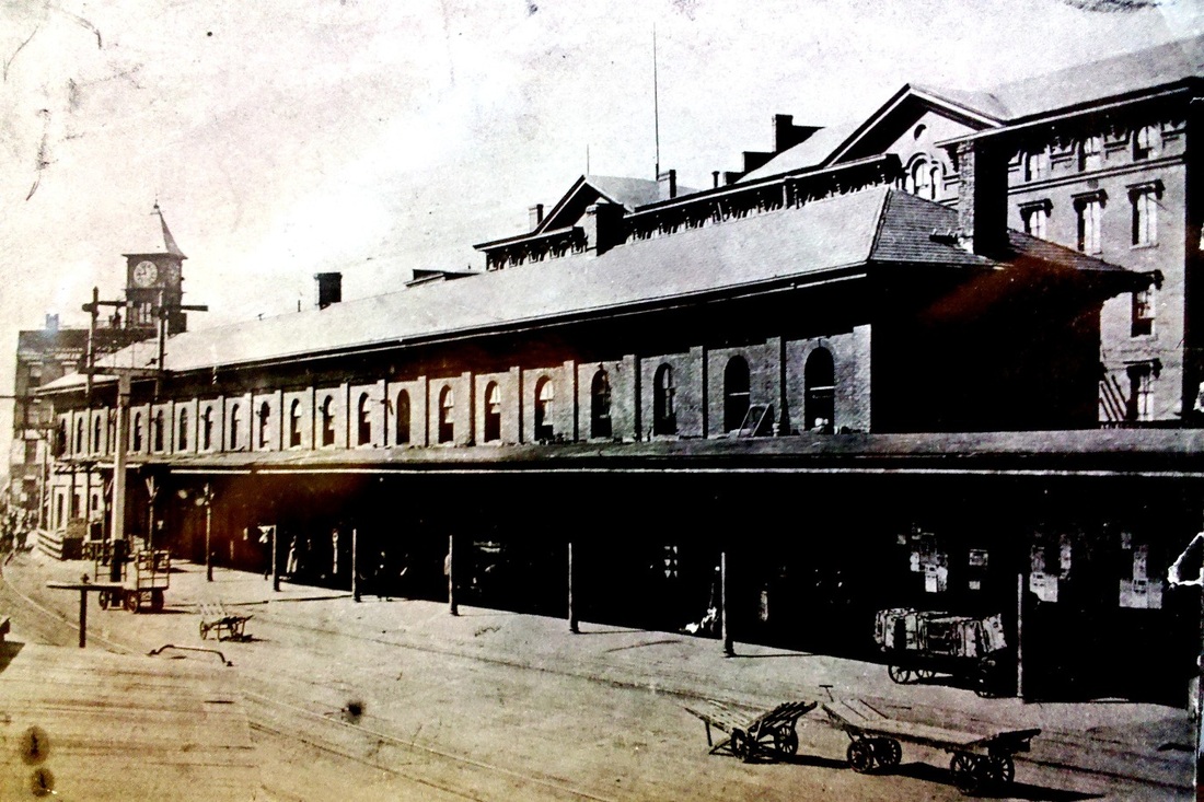
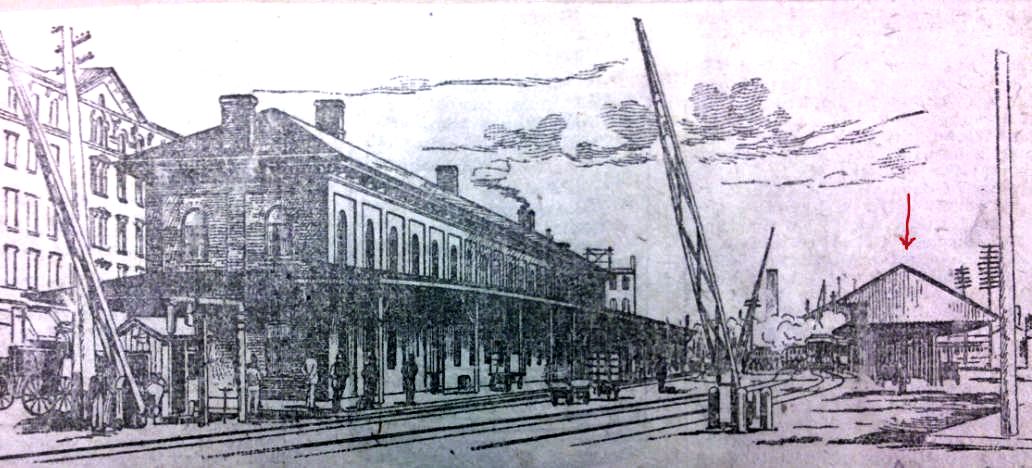
BRIDGEPORT3 [NY&NH, 1861]
This station opened on January 1, 1861. According to the NY&NH 1860 annual report, the HRR and the NRR declined an offer to participate at "joint fair proportional expense" in the erection of a station for "the mutual accommodation of the three Companies." The NY&NH then applied to the railroad commissioners on its own for an "up-town" location at Fairfield Ave. and Water St. where the older HRR depot was still standing. The Courant said in November, 1859 that the railroad commissioners had given their approval and that the depot would be built the following spring. Some delay or other resulted in a report in September, 1860 that a "new railroad depot, 200 feet long by 23 wide, and two stories high, for the N.Y. and N.H. Railroad Company, is under contract at Bridgeport." Though there is a newspaper reference in 1867 to an otherwise undocumented Naugatuck passenger station and one in 1873 to a Housatonic depot, we assume that the other roads abandoned BRIDGEPORT2 in 1861 and began to pay rental for use of the new NY&NH depot, a union station that was never really referred to as such. In 1890, the Register reported that the charge to the HRR was a surprisingly modest $300 per year. In 1880, a 31-ft addition was put on the south end of this station to give the Adams Express Co. more space. The improvements included lengthening the platform to 550 feet and erecting a covershed over it like the one at the recently built NEW HAVEN4. The expansion seems to also have added another chimney to what appear to have been the four original ones, as seen in the ca. 1870 stereo view image at [1]. The old track arrangement is seen in it as well, with the HRR crossing the NY&NH right at the station to reach its facilities on the harbor. A later cross-over would be farther west at the grain elevator, the towering structure seen in the distance. Continuing difficulties at this crossing, fueled by corporate antagonism on the part of the NYNH&H, led to armed combat by crews and the tearing up of tracks in the late 1880s. An amicable rearrangement of deeds and property rights in 1890 left the HRR actually owning the station until the Consolidated leased the HRR in 1892 and got it back. The photo at [2] is imprinted as 1868 in other copies but we used this one to show it mistaken for NORWALK5, which had a Mansard roof unlike BRIDGEPORT3. The shot at [3] shows HRR #8 in front of the station. The other views are some time after the addition, which can be seen in the portion without the covershed on the west end. The image at [5] is probably ca. 1900 and shows pedestrians and trolley tracks behind the station on Water St. While the track-elevation project was in progress, service continued on the street level tracks until this station closed in February, 1904. [REFS: RRC2.104 (11/22/1859); HDC/11/28/1859/02; CC/12/03/1859/02; NYNHAR1860,p6; NLDC /09/14/1860/02; HDC/09/19/1860/02; HDC/10/09/1860/02; HDC/12/29/1860 /02; HDC/04/24/1867/08; PS/05/14/1873/02; NHER/10/11/1880/01; NHER/09/03/1888/04; NHER/01/13/1890/01; HC/03/03/1890/08; FCHS, p1006; SL28. 3.6+][rev102215, rrd121816]
This station opened on January 1, 1861. According to the NY&NH 1860 annual report, the HRR and the NRR declined an offer to participate at "joint fair proportional expense" in the erection of a station for "the mutual accommodation of the three Companies." The NY&NH then applied to the railroad commissioners on its own for an "up-town" location at Fairfield Ave. and Water St. where the older HRR depot was still standing. The Courant said in November, 1859 that the railroad commissioners had given their approval and that the depot would be built the following spring. Some delay or other resulted in a report in September, 1860 that a "new railroad depot, 200 feet long by 23 wide, and two stories high, for the N.Y. and N.H. Railroad Company, is under contract at Bridgeport." Though there is a newspaper reference in 1867 to an otherwise undocumented Naugatuck passenger station and one in 1873 to a Housatonic depot, we assume that the other roads abandoned BRIDGEPORT2 in 1861 and began to pay rental for use of the new NY&NH depot, a union station that was never really referred to as such. In 1890, the Register reported that the charge to the HRR was a surprisingly modest $300 per year. In 1880, a 31-ft addition was put on the south end of this station to give the Adams Express Co. more space. The improvements included lengthening the platform to 550 feet and erecting a covershed over it like the one at the recently built NEW HAVEN4. The expansion seems to also have added another chimney to what appear to have been the four original ones, as seen in the ca. 1870 stereo view image at [1]. The old track arrangement is seen in it as well, with the HRR crossing the NY&NH right at the station to reach its facilities on the harbor. A later cross-over would be farther west at the grain elevator, the towering structure seen in the distance. Continuing difficulties at this crossing, fueled by corporate antagonism on the part of the NYNH&H, led to armed combat by crews and the tearing up of tracks in the late 1880s. An amicable rearrangement of deeds and property rights in 1890 left the HRR actually owning the station until the Consolidated leased the HRR in 1892 and got it back. The photo at [2] is imprinted as 1868 in other copies but we used this one to show it mistaken for NORWALK5, which had a Mansard roof unlike BRIDGEPORT3. The shot at [3] shows HRR #8 in front of the station. The other views are some time after the addition, which can be seen in the portion without the covershed on the west end. The image at [5] is probably ca. 1900 and shows pedestrians and trolley tracks behind the station on Water St. While the track-elevation project was in progress, service continued on the street level tracks until this station closed in February, 1904. [REFS: RRC2.104 (11/22/1859); HDC/11/28/1859/02; CC/12/03/1859/02; NYNHAR1860,p6; NLDC /09/14/1860/02; HDC/09/19/1860/02; HDC/10/09/1860/02; HDC/12/29/1860 /02; HDC/04/24/1867/08; PS/05/14/1873/02; NHER/10/11/1880/01; NHER/09/03/1888/04; NHER/01/13/1890/01; HC/03/03/1890/08; FCHS, p1006; SL28. 3.6+][rev102215, rrd121816]
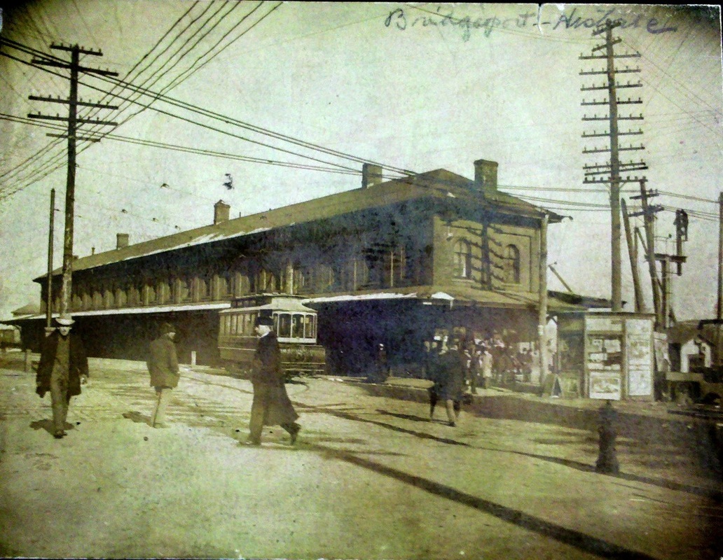
BRIDGEPORT4 [NYNH&H, 1891/92]
This undated sketch shows the street-level station on the eastbound side of the tracks put up by the NYNH&H in late 1891 or early 1892. This was occasioned by the release of BRIDGEPORT3 to the HRR after which there was the expectation that the NYNH&H would build its own new station. The Palladium ran a small item in October, 1891 saying that published reports that the NYNH&H was about to build a completely new depot "more costly and elaborate than any other on the road" had been denied by General Mgr. Tuttle. He said nothing would be done about a permanent structure until the four-tracking and elevation project was completed. In the meantime, however, he did say that the company was going to erect a "temporary wooden depot on the south side of the tracks, something after the plan of the depot at Westport" to afford comfortable accommodations to travelers taking trains across from the main station. It was expected to cost about $4,000. For this purpose, Tuttle said in July that the NYNH&H was going to purchase land between BRIDGEPORT3 and the Pequonnock River from the Miller and Strickland Co. coal dealers. In the sketch, all we can see is the covershed. Whatever stood here was expanded or replaced by BRIDGEPORT5 and later BRIDGEPORT7. [REFS: TR/08/23/1891/04; NHDP/10/07/1891/??; HC/04/03/1891/06; HC/07/14/1891/06][rev102215]
This undated sketch shows the street-level station on the eastbound side of the tracks put up by the NYNH&H in late 1891 or early 1892. This was occasioned by the release of BRIDGEPORT3 to the HRR after which there was the expectation that the NYNH&H would build its own new station. The Palladium ran a small item in October, 1891 saying that published reports that the NYNH&H was about to build a completely new depot "more costly and elaborate than any other on the road" had been denied by General Mgr. Tuttle. He said nothing would be done about a permanent structure until the four-tracking and elevation project was completed. In the meantime, however, he did say that the company was going to erect a "temporary wooden depot on the south side of the tracks, something after the plan of the depot at Westport" to afford comfortable accommodations to travelers taking trains across from the main station. It was expected to cost about $4,000. For this purpose, Tuttle said in July that the NYNH&H was going to purchase land between BRIDGEPORT3 and the Pequonnock River from the Miller and Strickland Co. coal dealers. In the sketch, all we can see is the covershed. Whatever stood here was expanded or replaced by BRIDGEPORT5 and later BRIDGEPORT7. [REFS: TR/08/23/1891/04; NHDP/10/07/1891/??; HC/04/03/1891/06; HC/07/14/1891/06][rev102215]

Bridgeport History Center
|
Bridgeport History Center
|
|
BRIDGEPORT5 [NYNH&H, 1904]
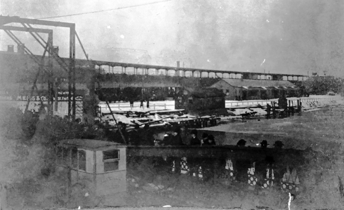
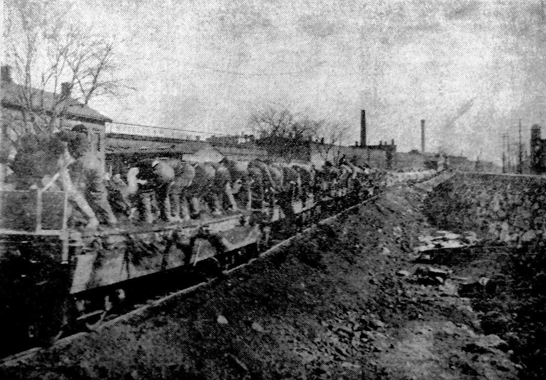
The photo at [1] shows the temporary structure that was used from February, 1904 to August, 1905. The shot at [2] shows the view from the Stratford Ave. bridge: covershed at the elevated track level and the temporary station at ground level. With the track-elevation project finally completed, the newspaper said early in 1904 that "work on the structure of this [new] station cannot be begun until the present one is entirely abandoned and torn down" and that "one by one the tenants of Bridgeport's chief relic of the past, the railroad station, have moved out," leaving only the ticket office and the newsstand which would probably move out within the week. The article went on to say that the "temporary station has been in readiness for them [for] some time" but problems with the new "overhead" tracks down by the grain elevator had prevented their use for several weeks. Apparently, extra fill was needed between the huge stone walls to stabilize this particularly soft mud-flat area. Eighteen months later when the new station was about to open, the paper said in August, 1905 that the "temporary station on the east end of the new building will be closed and removed in a few days." The paper went on to say on that "a big gang of men will be engaged in the task" that evening of transferring railroad property from the temporary station to the new one. A Courant article has given us an interesting tidbit of information on the fate of the interim station. Titled "Waterbury Gets It," it says "Another duty has been found by the New York, New Haven & Hartford road for the station that did temporary service at Bridgeport during the construction of the new depot in that city. The old station will be moved to Waterbury and is to be put up on West Main street, at the present New England road crossing." The photo at [3] is of the temporary depot reassembled in the Brass City while WATERBURY7 was being built. Thus ended the saga of the opening of BRIDGEPORT6 and of the massive construction project that elevated the tracks of the New York Division. The only image we have found of that work is seen at [4]. It is from an unidentified newspaper ca. 1940 with captioning that reads "Do you remember 'way back when -- There were 'wooden cars and iron men?' Here they are over 30 years ago, filling in the great ditch made with stone walls to elevate the tracks of the New Haven road. The location is Crescent avenue, east of East Main street and as far as the camera lens could see the 'iron men' are pitching off the dirt a spoonful at a time and in unison." With more photos like these, what a fascinating exhibit or article could be put together about this memorable chapter in Connecticut railroad history! [REFS: BEP/01/25/1904/01+; BEP/08/19/1905/01][rev102215, 121816]
The photo at [1] shows the temporary structure that was used from February, 1904 to August, 1905. The shot at [2] shows the view from the Stratford Ave. bridge: covershed at the elevated track level and the temporary station at ground level. With the track-elevation project finally completed, the newspaper said early in 1904 that "work on the structure of this [new] station cannot be begun until the present one is entirely abandoned and torn down" and that "one by one the tenants of Bridgeport's chief relic of the past, the railroad station, have moved out," leaving only the ticket office and the newsstand which would probably move out within the week. The article went on to say that the "temporary station has been in readiness for them [for] some time" but problems with the new "overhead" tracks down by the grain elevator had prevented their use for several weeks. Apparently, extra fill was needed between the huge stone walls to stabilize this particularly soft mud-flat area. Eighteen months later when the new station was about to open, the paper said in August, 1905 that the "temporary station on the east end of the new building will be closed and removed in a few days." The paper went on to say on that "a big gang of men will be engaged in the task" that evening of transferring railroad property from the temporary station to the new one. A Courant article has given us an interesting tidbit of information on the fate of the interim station. Titled "Waterbury Gets It," it says "Another duty has been found by the New York, New Haven & Hartford road for the station that did temporary service at Bridgeport during the construction of the new depot in that city. The old station will be moved to Waterbury and is to be put up on West Main street, at the present New England road crossing." The photo at [3] is of the temporary depot reassembled in the Brass City while WATERBURY7 was being built. Thus ended the saga of the opening of BRIDGEPORT6 and of the massive construction project that elevated the tracks of the New York Division. The only image we have found of that work is seen at [4]. It is from an unidentified newspaper ca. 1940 with captioning that reads "Do you remember 'way back when -- There were 'wooden cars and iron men?' Here they are over 30 years ago, filling in the great ditch made with stone walls to elevate the tracks of the New Haven road. The location is Crescent avenue, east of East Main street and as far as the camera lens could see the 'iron men' are pitching off the dirt a spoonful at a time and in unison." With more photos like these, what a fascinating exhibit or article could be put together about this memorable chapter in Connecticut railroad history! [REFS: BEP/01/25/1904/01+; BEP/08/19/1905/01][rev102215, 121816]
|

|
|

|

|
|

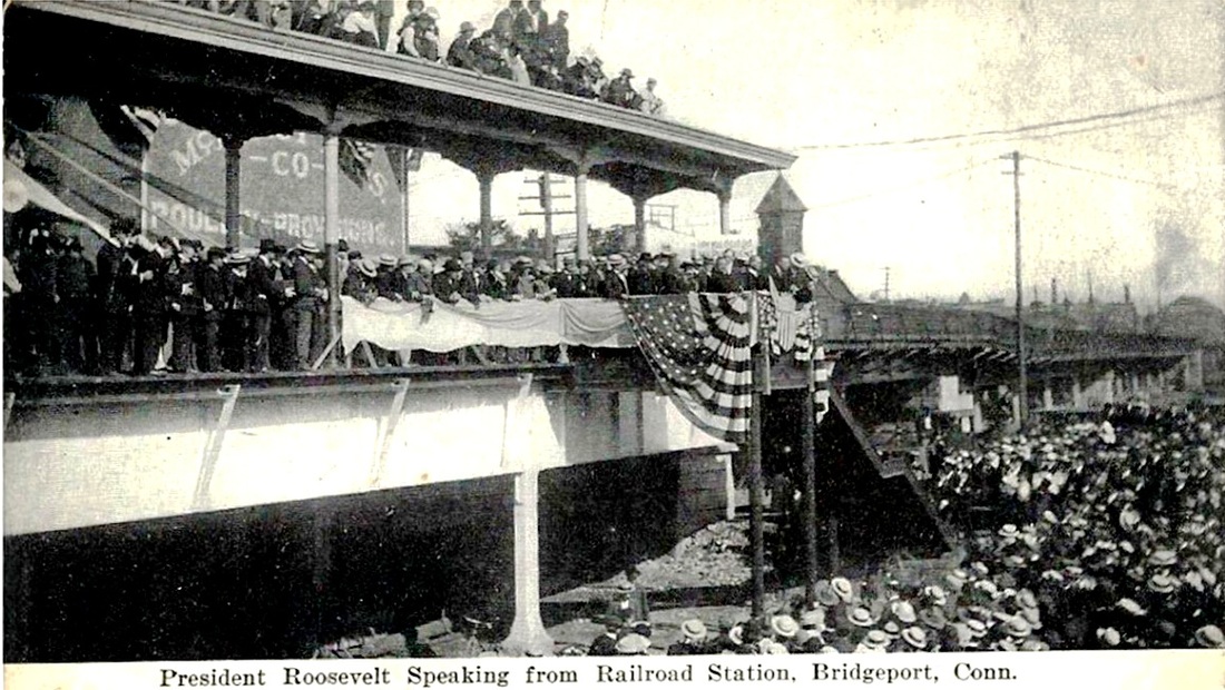
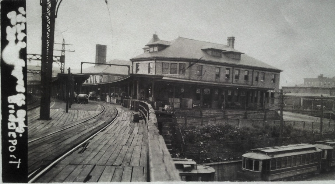
BRIDGEPORT6 [NYNH&H, 1905]
Ground was broken on 4/4/1904 for this station to replace the Civil War-era BRIDGEPORT3 and to accommodate the new elevated, four-track main line. That $4M project had just been finished, with the first train running above the streets on 1/31/1904. BRIDGEPORT6 would not be ready until more than a year and a half later, opening on 8/20/1905. The foundation for it was granite and the exterior was buff brick. A 115-ft tower at the Golden Hill St. side of the station was adorned by four copper gargoyles and a red slate roof topped the entire Romanesque structure that was designed by architect Warren R. Briggs. A street-level tunnel connected the main station with the eastbound platform and a long ramp up from Fairfield Ave. on the south end served, more or less, as the main entrance. The 160x70-ft waiting room had terrazzo and marble floors and a painted metal ceiling. There were freight, passenger and express elevators and over a thousand electric light bulbs illuminated the station and its surroundings. These improvements also included the opening of a new rolling lift drawbridge over the Pequonnock River. Until the old bridge was demolished, the swing span was left open, eliminating the old walkway and forcing pedestrians to use the Stratford Ave. or Congress St. bridges. As impressive as this station was, it was later said to have been too small and outdated within a decade. In the 1950s, Pres. McGinnis said it should be blown up(!) and a new station built in East Bridgeport where there was more room for parking. In derelict condition, this station was closed on 6/7/1973 and was being considered for refurbishment and other uses when an arson fire destroyed it on 3/20/1979. The view at [1] looks east with the old HRR line diverging to the north, an arrangement that caused the station platforms to be built in a unique V shape. The red arrow points to SS 28, Fairfield Ave, the tower built in 1904. According to retired tower operator Dale Martin, this was eliminated when SS-60 debuted on the bridge just east of the station. The post card at [2] is dated 9/8/1907 and shows the McElroy Bros. building on Water St. The same structure is seen behind Pres. Theodore Roosevelt at [3] when he spoke spoke to crowds at the north end of the HRR-side covershed on 6/29/1905. Electric operation began as far as Stamford on 10/6/1907 and was extended to New Haven by June, 1914; wires are up in the eastward view at [4]. The val photos at [5], [6], and [7] are dated 8/29/1917. [REFS: HC/07/17/1903/09; HC/08/07/1903/14: new bridge; BEP/02/01/1904/00; BEP/03/04/1904/00; HC/05/06/1904/15: old bridge being torn down; HC/06/30/1905/10; CRC53.1905.25; BEP/08/14/1905/00; HC/08/15/1905/05; BEP/08/19/1905/01; NYT/10/05/1907/04; NYT/06/18/1914/30; HC/03/21/1979/1A; NL19.1.8; R36][rev102215, 121816]
Ground was broken on 4/4/1904 for this station to replace the Civil War-era BRIDGEPORT3 and to accommodate the new elevated, four-track main line. That $4M project had just been finished, with the first train running above the streets on 1/31/1904. BRIDGEPORT6 would not be ready until more than a year and a half later, opening on 8/20/1905. The foundation for it was granite and the exterior was buff brick. A 115-ft tower at the Golden Hill St. side of the station was adorned by four copper gargoyles and a red slate roof topped the entire Romanesque structure that was designed by architect Warren R. Briggs. A street-level tunnel connected the main station with the eastbound platform and a long ramp up from Fairfield Ave. on the south end served, more or less, as the main entrance. The 160x70-ft waiting room had terrazzo and marble floors and a painted metal ceiling. There were freight, passenger and express elevators and over a thousand electric light bulbs illuminated the station and its surroundings. These improvements also included the opening of a new rolling lift drawbridge over the Pequonnock River. Until the old bridge was demolished, the swing span was left open, eliminating the old walkway and forcing pedestrians to use the Stratford Ave. or Congress St. bridges. As impressive as this station was, it was later said to have been too small and outdated within a decade. In the 1950s, Pres. McGinnis said it should be blown up(!) and a new station built in East Bridgeport where there was more room for parking. In derelict condition, this station was closed on 6/7/1973 and was being considered for refurbishment and other uses when an arson fire destroyed it on 3/20/1979. The view at [1] looks east with the old HRR line diverging to the north, an arrangement that caused the station platforms to be built in a unique V shape. The red arrow points to SS 28, Fairfield Ave, the tower built in 1904. According to retired tower operator Dale Martin, this was eliminated when SS-60 debuted on the bridge just east of the station. The post card at [2] is dated 9/8/1907 and shows the McElroy Bros. building on Water St. The same structure is seen behind Pres. Theodore Roosevelt at [3] when he spoke spoke to crowds at the north end of the HRR-side covershed on 6/29/1905. Electric operation began as far as Stamford on 10/6/1907 and was extended to New Haven by June, 1914; wires are up in the eastward view at [4]. The val photos at [5], [6], and [7] are dated 8/29/1917. [REFS: HC/07/17/1903/09; HC/08/07/1903/14: new bridge; BEP/02/01/1904/00; BEP/03/04/1904/00; HC/05/06/1904/15: old bridge being torn down; HC/06/30/1905/10; CRC53.1905.25; BEP/08/14/1905/00; HC/08/15/1905/05; BEP/08/19/1905/01; NYT/10/05/1907/04; NYT/06/18/1914/30; HC/03/21/1979/1A; NL19.1.8; R36][rev102215, 121816]
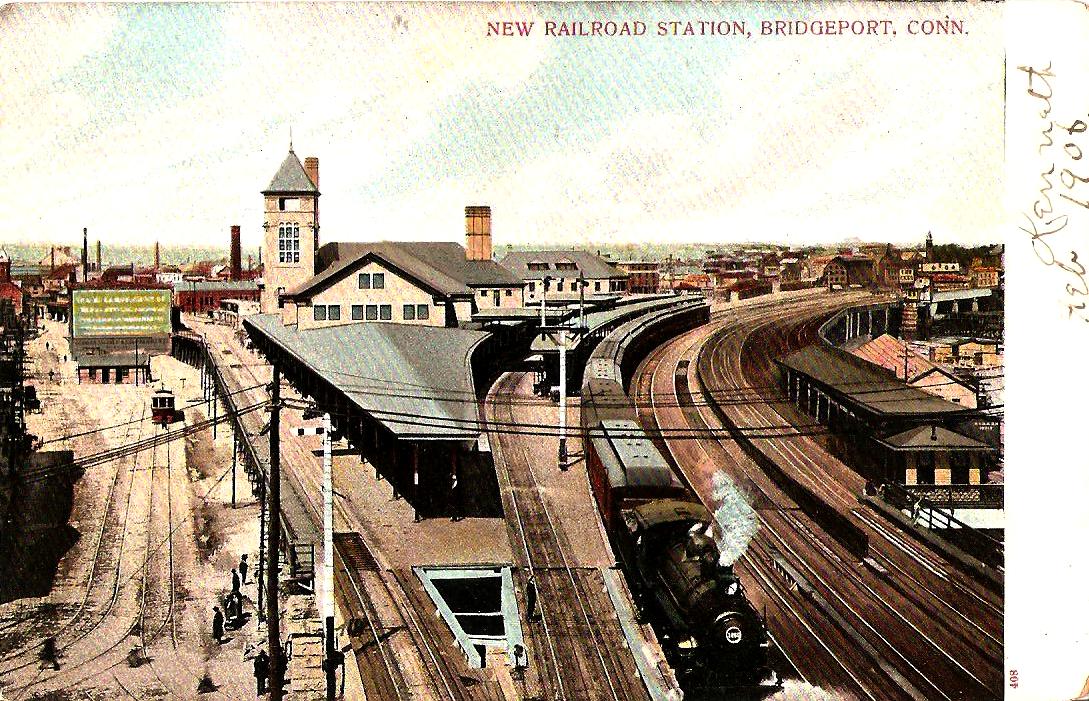
|
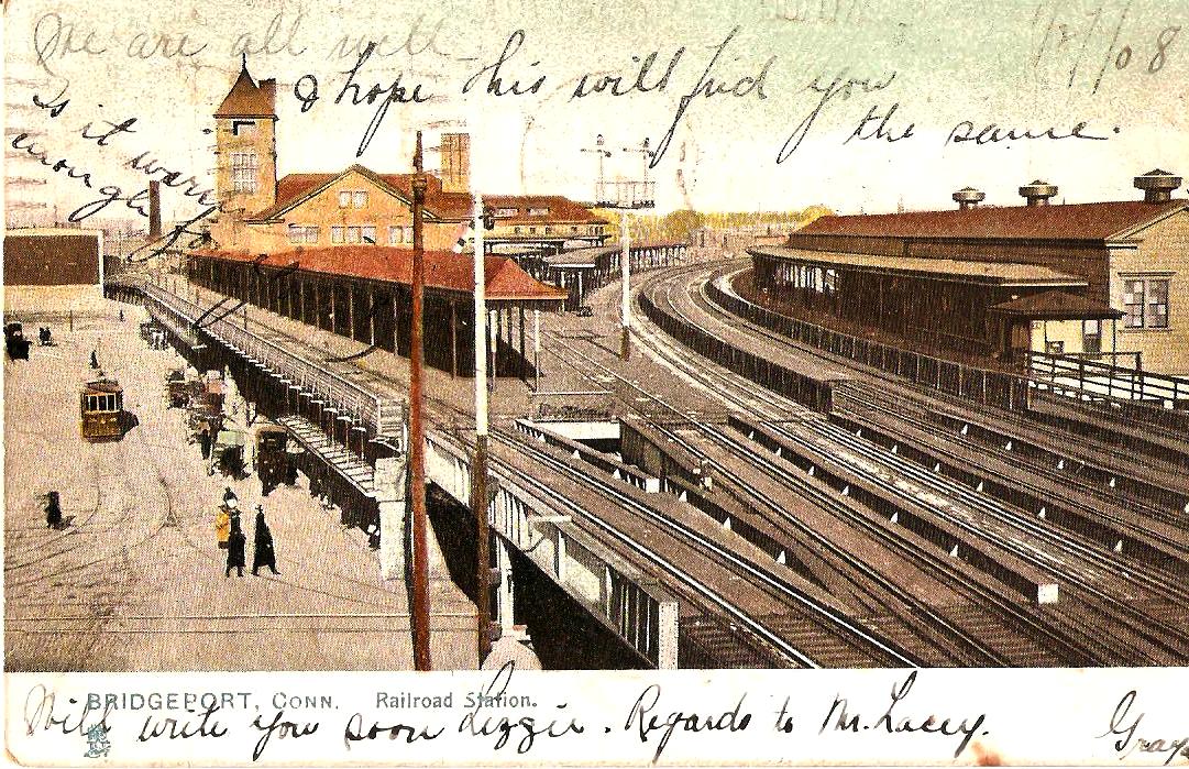
|
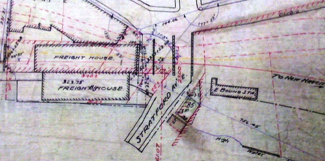
|
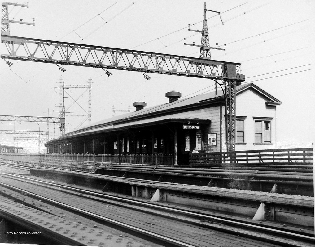
|
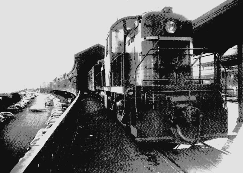
Copyright NHRHTA
|
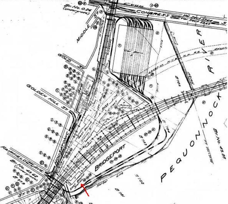
|
BRIDGEPORT7 [NYNH&H, c1907]
Months before BRIDGEPORT6 opened in August, 1905, newspapers were reporting in May that a station was also going to be built on the east side of the tracks, where BRIDGEPORT4 and BRIDGEPORT5 had stood. The Ansonia Evening Sentinel article said: "Another Depot for Bridgeport. While accepting the plan proposed by Supervising Architect Warren R. Briggs, on behalf of the New York, New Haven and Hartford Railroad company, for a waiting room and shelter said on the east side of the platform of the new passenger station, the board of trade committee on railroad improvements has informed Mr. Briggs that another depot is an urgent necessity...." An article from an unidentified paper added that Briggs presented plans for a temporary station to be "100 feet long and twenty-four feet wide... supplied with the modern conveniences for passengers waiting for trains, but it will not have a ticket office." Bridgeport Board of Trade President Fred Enos was said to not be satisfied but glad for what the railroad was willing to give. He was of the opinion, however, that within five years the railroad would be "obliged to build a permanent and solid structure on the east side for their passenger traffic and equip it with a ticket office." The 1906 postcard at [1] shows just a small covershed on the eastbound side, while the 1/27/1908 image at [2] shows a substantial gabled building behind a longer, curved canopy as well as a shed that protected passengers while boarding trains on Track 6. Both the 1910 real estate map at [3] and the 1915 val map at [6] show the footprint of BRIDGEPORT7 without the adjacent appendages. The 1913 Sanborn map we have seen shows the eastbound structure as 'Iron Clad' and extending from the 'waiting room' at Stratford Ave. all the way up to opposite the north end of the main passenger station. Nothing further is found in the newspapers or the railroad commissioners reports to clarify more exactly when this structure was put up or the extent of the amenities it provided, but the next Sanborn map shows the same-length structure in 1939 with no waiting room indicated at the south end by that time. Passengers thereafter must have stayed at the main station and descended to the concourse beneath the tracks to come up the stairs on the east side to get trains there. We recall public entrances to the 1905 station on Water St. at the foot of Golden Hill St., at the north end of the main station where you drove in under the Berkshire line overpass at the foot of Gold St., and at the south end via the Fairfield Ave. pedestrian ramp that was touted as quite an innovation when it debuted. The photo at [4] shows the structure after the 1914 electrification. In addition to points east, passengers board trains here pulled by diesels for the non-electrified Naugatuck line, as seen at [5]. The 1915 val map at [6] shows the elaborate intermodal transportation complex that the NYNH&H put together for the Park City. BRIDGEPORT7 is at the red arrow and a streetcar loop circles around the back of the station through what we knew as just a parking lot, goes under the elevated tracks, and into the carbarns that had a clever pass-through arrangement to Congress St. The express building, utilized by Adams before the Railway Express Agency was created, is seen south of the trolley barn complex that was only recently torn down. [REFS: AES/05/15/1905/05; AES?/05/18/1905/03; HC/08/29/1905/13][rev041715, rrd121816]
Months before BRIDGEPORT6 opened in August, 1905, newspapers were reporting in May that a station was also going to be built on the east side of the tracks, where BRIDGEPORT4 and BRIDGEPORT5 had stood. The Ansonia Evening Sentinel article said: "Another Depot for Bridgeport. While accepting the plan proposed by Supervising Architect Warren R. Briggs, on behalf of the New York, New Haven and Hartford Railroad company, for a waiting room and shelter said on the east side of the platform of the new passenger station, the board of trade committee on railroad improvements has informed Mr. Briggs that another depot is an urgent necessity...." An article from an unidentified paper added that Briggs presented plans for a temporary station to be "100 feet long and twenty-four feet wide... supplied with the modern conveniences for passengers waiting for trains, but it will not have a ticket office." Bridgeport Board of Trade President Fred Enos was said to not be satisfied but glad for what the railroad was willing to give. He was of the opinion, however, that within five years the railroad would be "obliged to build a permanent and solid structure on the east side for their passenger traffic and equip it with a ticket office." The 1906 postcard at [1] shows just a small covershed on the eastbound side, while the 1/27/1908 image at [2] shows a substantial gabled building behind a longer, curved canopy as well as a shed that protected passengers while boarding trains on Track 6. Both the 1910 real estate map at [3] and the 1915 val map at [6] show the footprint of BRIDGEPORT7 without the adjacent appendages. The 1913 Sanborn map we have seen shows the eastbound structure as 'Iron Clad' and extending from the 'waiting room' at Stratford Ave. all the way up to opposite the north end of the main passenger station. Nothing further is found in the newspapers or the railroad commissioners reports to clarify more exactly when this structure was put up or the extent of the amenities it provided, but the next Sanborn map shows the same-length structure in 1939 with no waiting room indicated at the south end by that time. Passengers thereafter must have stayed at the main station and descended to the concourse beneath the tracks to come up the stairs on the east side to get trains there. We recall public entrances to the 1905 station on Water St. at the foot of Golden Hill St., at the north end of the main station where you drove in under the Berkshire line overpass at the foot of Gold St., and at the south end via the Fairfield Ave. pedestrian ramp that was touted as quite an innovation when it debuted. The photo at [4] shows the structure after the 1914 electrification. In addition to points east, passengers board trains here pulled by diesels for the non-electrified Naugatuck line, as seen at [5]. The 1915 val map at [6] shows the elaborate intermodal transportation complex that the NYNH&H put together for the Park City. BRIDGEPORT7 is at the red arrow and a streetcar loop circles around the back of the station through what we knew as just a parking lot, goes under the elevated tracks, and into the carbarns that had a clever pass-through arrangement to Congress St. The express building, utilized by Adams before the Railway Express Agency was created, is seen south of the trolley barn complex that was only recently torn down. [REFS: AES/05/15/1905/05; AES?/05/18/1905/03; HC/08/29/1905/13][rev041715, rrd121816]
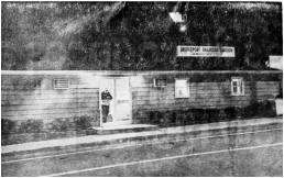 Bridgeport Post
BRIDGEPORT8 [PC, 1973]
This was the temporary station that served passengers after BRIDGEPORT6 closed on 6/7/1973. It stood opposite the Municipal Bus Terminal on Water St. and travelers used the stairs built for the coming permanent station to access trains. [add102215, rrd121816]
This was the temporary station that served passengers after BRIDGEPORT6 closed on 6/7/1973. It stood opposite the Municipal Bus Terminal on Water St. and travelers used the stairs built for the coming permanent station to access trains. [add102215, rrd121816]
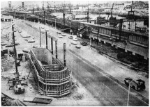
Bridgeport Post
|

|

|
BRIDGEPORT9 [PC, 1975]
Designed by Antinozzi Associates and built by Kepetan, Inc., this station straddles Water St. and is still in service today in 2016. It was dedicated on 10/27/1985 and opened for business at that time. The photo at [1] dates to 5/23/1974; it shows work in progress on the new station and stairs up to the high-level platforms to accommodate the M-2 rail cars. The image at [2] shows the completed structure, said candidly by some to be 'brutalist' in design, and we agree! The shot at [3] is from the 1980s. [rev102215, 121816]
Designed by Antinozzi Associates and built by Kepetan, Inc., this station straddles Water St. and is still in service today in 2016. It was dedicated on 10/27/1985 and opened for business at that time. The photo at [1] dates to 5/23/1974; it shows work in progress on the new station and stairs up to the high-level platforms to accommodate the M-2 rail cars. The image at [2] shows the completed structure, said candidly by some to be 'brutalist' in design, and we agree! The shot at [3] is from the 1980s. [rev102215, 121816]
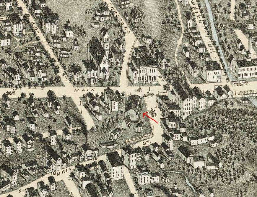
|
|
BRISTOL1 [HP&F, 1850]
The snippet on the left is from the 1878 Bailey bird's-eye map [click here] and, when compared to the stereopticon view at right, it seems as if Mr. Bailey has misinterpreted the roof gables. A similar situation occurred with NEW BRITAIN1 on his 1875 map in that town, leading us to think that there were new structures in both municipalities until further research proved us wrong. BRISTOL1 was built in 1850 by the HP&F and, with its tall center gable, it is similar to the company's NEW BRITAIN1 and TERRYVILLE1 depots. This one apparently stood until an "equinoctial" storm of snow, rain, hail, thunder and lightning about 1:00 a.m. on the morning of 3/20/1886. The same wide-ranging weather event also destroyed FARMINGTON1 and damaged CHESHIRE, all by fires thought to be the result of ungrounded telegraph wires that conducted lightning into the buildings. Though there were newspaper reports in 1881 and 1882 of a new depot coming for Bristol and the Courant said the station burned in the storm was a year or so old, the Bristol Weekly Press, more credible by proximity, states that depot that burned "was renovated thoroughly a year or two ago," not built at that time. This leads us to believe that it was BRISTOL1 that was destroyed by the storm, not a subsequent station that we otherwise have no record of being constructed. The span of 19 months that it took to plan and build a new permanent station also appears to argue against an intervening one, which could have been rebuilt almost immediately if recent plans were still in hand. In fact, the Press said that on Saturday, the same day of the fire, "a small temporary depot was begun up the track and finished on Sunday." While the newspapers commended the NY&NE on its speed in constructing the temporary replacement, local appreciation morphed into petitions from leading businessmen to Pres. Charles Peter Clark in July about why it was taking so long to build a new permanent depot. [REFS: HDC/05/25/1881/01; HDC/09/18/1882/02; NHER/03/20/1886/01; HDC/03/22/ 1886/03; NHER/03/22/1886/04; BWP/03/25/1886/04; BWP/07/29/1886/02; D129 ][rev121816]
The snippet on the left is from the 1878 Bailey bird's-eye map [click here] and, when compared to the stereopticon view at right, it seems as if Mr. Bailey has misinterpreted the roof gables. A similar situation occurred with NEW BRITAIN1 on his 1875 map in that town, leading us to think that there were new structures in both municipalities until further research proved us wrong. BRISTOL1 was built in 1850 by the HP&F and, with its tall center gable, it is similar to the company's NEW BRITAIN1 and TERRYVILLE1 depots. This one apparently stood until an "equinoctial" storm of snow, rain, hail, thunder and lightning about 1:00 a.m. on the morning of 3/20/1886. The same wide-ranging weather event also destroyed FARMINGTON1 and damaged CHESHIRE, all by fires thought to be the result of ungrounded telegraph wires that conducted lightning into the buildings. Though there were newspaper reports in 1881 and 1882 of a new depot coming for Bristol and the Courant said the station burned in the storm was a year or so old, the Bristol Weekly Press, more credible by proximity, states that depot that burned "was renovated thoroughly a year or two ago," not built at that time. This leads us to believe that it was BRISTOL1 that was destroyed by the storm, not a subsequent station that we otherwise have no record of being constructed. The span of 19 months that it took to plan and build a new permanent station also appears to argue against an intervening one, which could have been rebuilt almost immediately if recent plans were still in hand. In fact, the Press said that on Saturday, the same day of the fire, "a small temporary depot was begun up the track and finished on Sunday." While the newspapers commended the NY&NE on its speed in constructing the temporary replacement, local appreciation morphed into petitions from leading businessmen to Pres. Charles Peter Clark in July about why it was taking so long to build a new permanent depot. [REFS: HDC/05/25/1881/01; HDC/09/18/1882/02; NHER/03/20/1886/01; HDC/03/22/ 1886/03; NHER/03/22/1886/04; BWP/03/25/1886/04; BWP/07/29/1886/02; D129 ][rev121816]
BRISTOL2 [NY&NE, 1886]
This was the small replacement depot built after BRISTOL1 burned. It was said to be "up the track" which most likely meant a little west of the earlier structure. In March, 1887, a year after the fire when a new depot was reported to finally be in the offing, the Press said "it is now about a year since the old station was burned, and the public has had to put up with a dry goods box all this time, and not always good humoredly. A year is a long time to wait and much inclement weather makes it seem longer still." A dry goods box, indeed! This small depot would be used from 3/20/1886 until 10/1/1887 when BRISTOL3 opened. We have no picture yet of this structure that we are aware of but, as frugal as railroads were in those days, it may yet show up in another photo if it was put to further use after it ceased serving passengers. [REFS: BWP/03/17/1887/04][rev121816]
This was the small replacement depot built after BRISTOL1 burned. It was said to be "up the track" which most likely meant a little west of the earlier structure. In March, 1887, a year after the fire when a new depot was reported to finally be in the offing, the Press said "it is now about a year since the old station was burned, and the public has had to put up with a dry goods box all this time, and not always good humoredly. A year is a long time to wait and much inclement weather makes it seem longer still." A dry goods box, indeed! This small depot would be used from 3/20/1886 until 10/1/1887 when BRISTOL3 opened. We have no picture yet of this structure that we are aware of but, as frugal as railroads were in those days, it may yet show up in another photo if it was put to further use after it ceased serving passengers. [REFS: BWP/03/17/1887/04][rev121816]
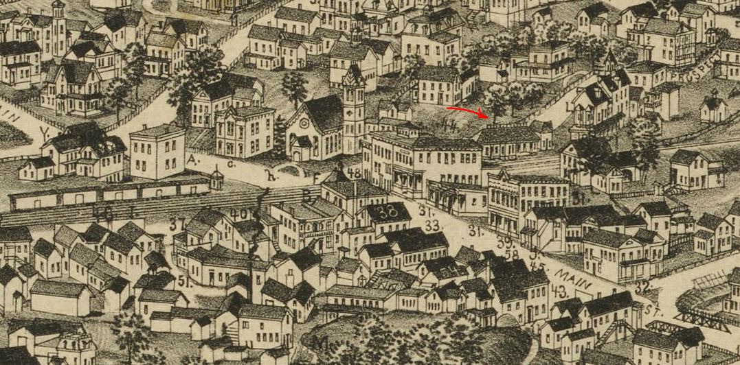
Boston Public Library
|

Dave Peters Collection
|

|
|
|
Bristol Public Library
|
BRISTOL3 [NY&NE, 1887]
Impatient for the new station, the Bristol Weekly Press was quoted in February, 1887 as wondering "what about that fine new depot that was to be built?" and further saying humorously that, if the derelict, soon-to-be-replaced NEW BRITAIN1 was being brought here by the NY&NE, there should be a vigorous protest! The contract for Bristol's new station was signed on 4/25/1887. An original copy can be seen in the Bristol History Room at the city library, which is well worth a visit. When BRISTOL3 opened on 10/1/1887, the Press noted it with just a single sentence: "The depot came into use last Saturday." The "incandescent electric lamps" touted in a previous article notwithstanding, there was considerable envy and resentment of the magnificent, towering brick edifice with porte cochere in New Britain that so overshadowed Bristol's simple, one-story depot. When it came time in 1898 to re-position BRISTOL3 for arrival of the third-rail cars, the paper said with dripping sarcasm that "Bristol's elegant passenger station, in which we all take so much pride, is to be moved across the tracks next Sunday. The regrettable feature is that it is to go only a few feet south. The advisable thing to do, when once it got started, would be to keep it on a southerly course until it reached Cuba. It could then be covered with corrugated iron and converted into a place of detention for Spanish prisoners. Then Bristol would take a pride in it that was not ironical. However, the building will do duty for years, probably. Mr. Fred Linstead has the contract for moving it." References to the Spanish-American War aside, the town was not happy with its depot! Another sore subject was the dangerous Main St. grade crossing and an 1899 Courant article gives details on that. In 1889, a law was passed stipulating that railroads in the state had to eliminate one grade crossing annually for every 60 miles of mainline track operated. The NY&NE failed to satisfy this requirement in 1891 and the railroad commissioners, acting within their statutory powers, chose this crossing to be eliminated to make up for the others not done. The then-estimated $100,000 cost led the NY&NE to fight the order and challenge the borough of Bristol all the way to the U.S. Supreme Court [click here], which in 1894 upheld the statute and affirmed the commissioners' actions. The new lessee of the line, the NYNH&H, still had to be prodded to undertake the massive excavation to lower Main St. When the new iron bridge was completed on 1/1/1901, the project was finally finished. The shot at [1], from the George E. Norris bird's-eye map of 1889 [click here], shows the depot shortly after it opened in its new location, northeast of the Main St. crossing. The val photo at [2] is dated 8/21/1916 and the dotted lines on the 1916 val map at [3] reflect the realignment of the right of way in 1900. The post card view at [4] shows Prospect Park created in 1906 from the land where the tracks once were. The historic shot at [5] dates to between 1898 and 1900 and shows the agent's bay temporarily not at trackside! How that was addressed on the other side of the building is not yet known because the old tracks on the north side of the depot, which show a third-rail electric car here, would not be relaid south of the station until November, 1900. In March, 1954, the Press reported that BRISTOL3 been had been purchased from the NYNH&H on 10/26/1953 by developer Allen M. Heflin who sold the land, including the park, to some local banks. With accommodations made for passengers at the freight station across Main St., BRISTOL3 passed through a succession of humble uses in the 1960s. It opened in 1970 as the Iron Horse and later the Bristol Station Restaurant, flanked by two rail cars, one of which was the former Merchants Limited diner. The last operation closed about four years later and fire struck the dining car on 8/8/1975. The depot was spared the flames but was said at the time to so little resemble a station inside as to not be worth preserving, though the local historical society made some efforts. It was razed, in an altogether too familiar scenario, for a parking lot. Demolition began on 5/15/1976. The photo at [6] shows the depot after it was closed in April, 1954. The stairway that was necessitated by the 1900 excavation project and was only covered in 1911 after numerous slip-and-fall incidents, is now boarded up. The gabled structure to its left on the sidewalk housed a stone drinking fountain, a public amenity built in 1901 on a patch of land leased to the city by the NYNH&H. In the contract, also in the Bristol History Room, it specifies that "the lessee shall pay as rent the sum of one dollar on the 8th day of every August," probably just enough to make it all legal and symbolically conclude decades of public complaint, legal action, and belated railroad improvement in Bristol. [REFS: NHER/03/20/1886/01; HDC/03/22/1886/03; CRC35.1887.16; HDC/02/05/1887/04; BWP/03/10/1887/04; BWP/03/17/1887/04; HDC/06/23/1887/04; BWP/09/29/1887/04; BWP/10/06/1887/04; BWP/06/16/1898/01; HC/06/16/1898/11; HC/10/25/1899/05; HC/11/15/1899/03; BRP/11/11/1900/01; HC/11/24/1900/12; HC/12/08/1900/12; HC/01/02/1901/10; HC/08/23/1901/16; BRP/03/29/1906/02; HC/07/29/1911/18; BRP/03/10/1954/??; BRP/01/23/1960/01; HC/10/04/1970 /20J; HC/08/10/1975/2B1; HC/02/25/1976/61B; HC/04/03/1976/25A; BRP/05/15/1976/01; D130][rev011417, 110420]
Impatient for the new station, the Bristol Weekly Press was quoted in February, 1887 as wondering "what about that fine new depot that was to be built?" and further saying humorously that, if the derelict, soon-to-be-replaced NEW BRITAIN1 was being brought here by the NY&NE, there should be a vigorous protest! The contract for Bristol's new station was signed on 4/25/1887. An original copy can be seen in the Bristol History Room at the city library, which is well worth a visit. When BRISTOL3 opened on 10/1/1887, the Press noted it with just a single sentence: "The depot came into use last Saturday." The "incandescent electric lamps" touted in a previous article notwithstanding, there was considerable envy and resentment of the magnificent, towering brick edifice with porte cochere in New Britain that so overshadowed Bristol's simple, one-story depot. When it came time in 1898 to re-position BRISTOL3 for arrival of the third-rail cars, the paper said with dripping sarcasm that "Bristol's elegant passenger station, in which we all take so much pride, is to be moved across the tracks next Sunday. The regrettable feature is that it is to go only a few feet south. The advisable thing to do, when once it got started, would be to keep it on a southerly course until it reached Cuba. It could then be covered with corrugated iron and converted into a place of detention for Spanish prisoners. Then Bristol would take a pride in it that was not ironical. However, the building will do duty for years, probably. Mr. Fred Linstead has the contract for moving it." References to the Spanish-American War aside, the town was not happy with its depot! Another sore subject was the dangerous Main St. grade crossing and an 1899 Courant article gives details on that. In 1889, a law was passed stipulating that railroads in the state had to eliminate one grade crossing annually for every 60 miles of mainline track operated. The NY&NE failed to satisfy this requirement in 1891 and the railroad commissioners, acting within their statutory powers, chose this crossing to be eliminated to make up for the others not done. The then-estimated $100,000 cost led the NY&NE to fight the order and challenge the borough of Bristol all the way to the U.S. Supreme Court [click here], which in 1894 upheld the statute and affirmed the commissioners' actions. The new lessee of the line, the NYNH&H, still had to be prodded to undertake the massive excavation to lower Main St. When the new iron bridge was completed on 1/1/1901, the project was finally finished. The shot at [1], from the George E. Norris bird's-eye map of 1889 [click here], shows the depot shortly after it opened in its new location, northeast of the Main St. crossing. The val photo at [2] is dated 8/21/1916 and the dotted lines on the 1916 val map at [3] reflect the realignment of the right of way in 1900. The post card view at [4] shows Prospect Park created in 1906 from the land where the tracks once were. The historic shot at [5] dates to between 1898 and 1900 and shows the agent's bay temporarily not at trackside! How that was addressed on the other side of the building is not yet known because the old tracks on the north side of the depot, which show a third-rail electric car here, would not be relaid south of the station until November, 1900. In March, 1954, the Press reported that BRISTOL3 been had been purchased from the NYNH&H on 10/26/1953 by developer Allen M. Heflin who sold the land, including the park, to some local banks. With accommodations made for passengers at the freight station across Main St., BRISTOL3 passed through a succession of humble uses in the 1960s. It opened in 1970 as the Iron Horse and later the Bristol Station Restaurant, flanked by two rail cars, one of which was the former Merchants Limited diner. The last operation closed about four years later and fire struck the dining car on 8/8/1975. The depot was spared the flames but was said at the time to so little resemble a station inside as to not be worth preserving, though the local historical society made some efforts. It was razed, in an altogether too familiar scenario, for a parking lot. Demolition began on 5/15/1976. The photo at [6] shows the depot after it was closed in April, 1954. The stairway that was necessitated by the 1900 excavation project and was only covered in 1911 after numerous slip-and-fall incidents, is now boarded up. The gabled structure to its left on the sidewalk housed a stone drinking fountain, a public amenity built in 1901 on a patch of land leased to the city by the NYNH&H. In the contract, also in the Bristol History Room, it specifies that "the lessee shall pay as rent the sum of one dollar on the 8th day of every August," probably just enough to make it all legal and symbolically conclude decades of public complaint, legal action, and belated railroad improvement in Bristol. [REFS: NHER/03/20/1886/01; HDC/03/22/1886/03; CRC35.1887.16; HDC/02/05/1887/04; BWP/03/10/1887/04; BWP/03/17/1887/04; HDC/06/23/1887/04; BWP/09/29/1887/04; BWP/10/06/1887/04; BWP/06/16/1898/01; HC/06/16/1898/11; HC/10/25/1899/05; HC/11/15/1899/03; BRP/11/11/1900/01; HC/11/24/1900/12; HC/12/08/1900/12; HC/01/02/1901/10; HC/08/23/1901/16; BRP/03/29/1906/02; HC/07/29/1911/18; BRP/03/10/1954/??; BRP/01/23/1960/01; HC/10/04/1970 /20J; HC/08/10/1975/2B1; HC/02/25/1976/61B; HC/04/03/1976/25A; BRP/05/15/1976/01; D130][rev011417, 110420]
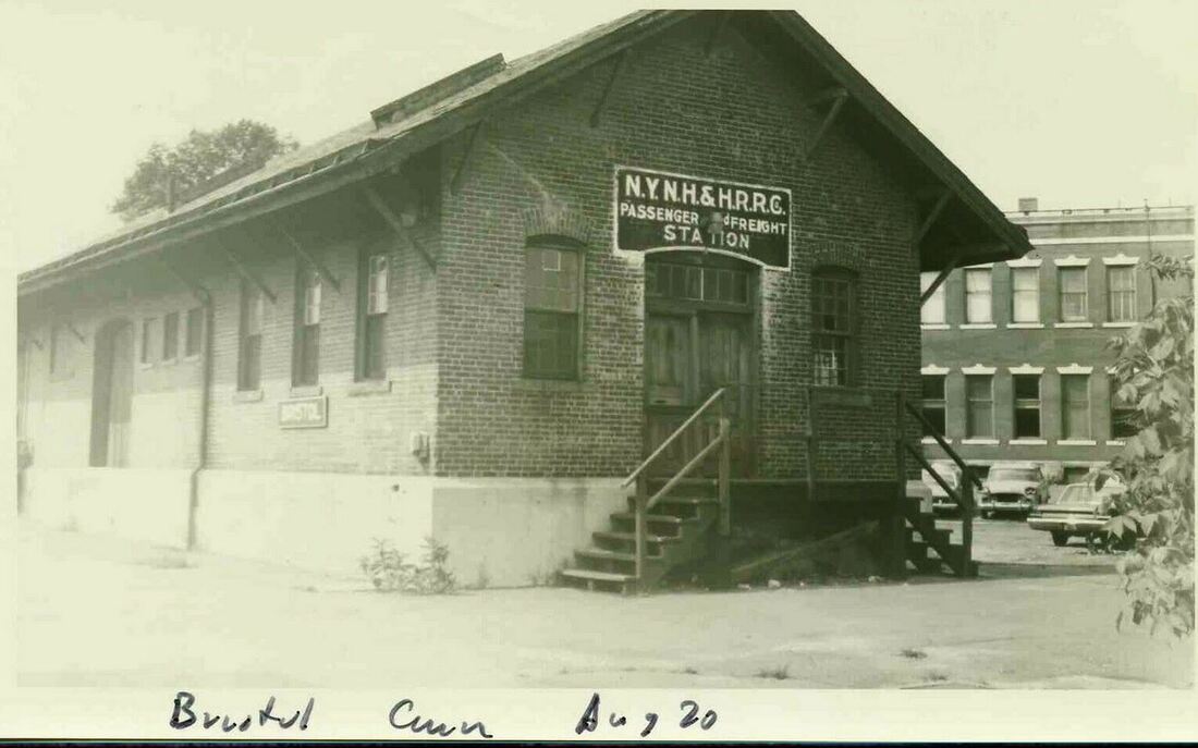
|
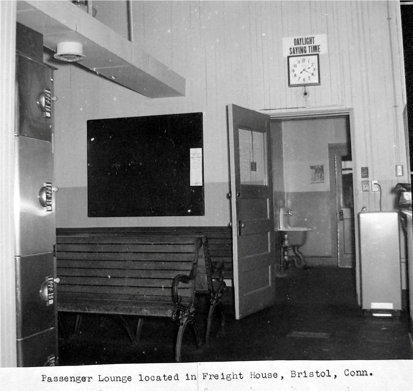
|
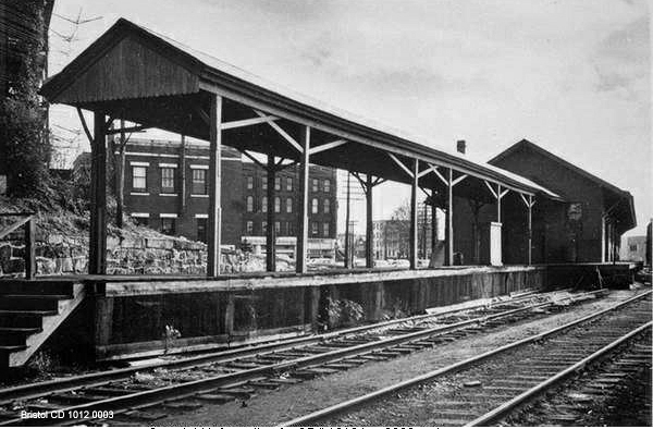
|
BRISTOL4 [NYNH&H, 1954]
With BRISTOL3 sold in 1953 and soon to be out of railroad service, other arrangements had to be made. The decision was to turn the freight house across Main St. into a combination station like the old days. The Press of 3/10/1954 said that the railroad had until April 26 to make room in the freight house for the ticket office, Railway Express Agency, and the taxi operation. The result is seen in the photo at [1] The lounge, seen in the photo at [2], served as the final passenger station in Bristol until the last Budd car pulled out in 1960. The coversheds at [3], which we have seen in a much earlier val photo, pre-dated these changes. The freight station itself would later become a source of friction between the railroad and the city until it was torn down by Conrail in 1977. [REFS: BRP/01/23/1960/01; HC/04/23/1977/27; HC/08/02/1977/19A][rev081313, 080619]
With BRISTOL3 sold in 1953 and soon to be out of railroad service, other arrangements had to be made. The decision was to turn the freight house across Main St. into a combination station like the old days. The Press of 3/10/1954 said that the railroad had until April 26 to make room in the freight house for the ticket office, Railway Express Agency, and the taxi operation. The result is seen in the photo at [1] The lounge, seen in the photo at [2], served as the final passenger station in Bristol until the last Budd car pulled out in 1960. The coversheds at [3], which we have seen in a much earlier val photo, pre-dated these changes. The freight station itself would later become a source of friction between the railroad and the city until it was torn down by Conrail in 1977. [REFS: BRP/01/23/1960/01; HC/04/23/1977/27; HC/08/02/1977/19A][rev081313, 080619]

|

|
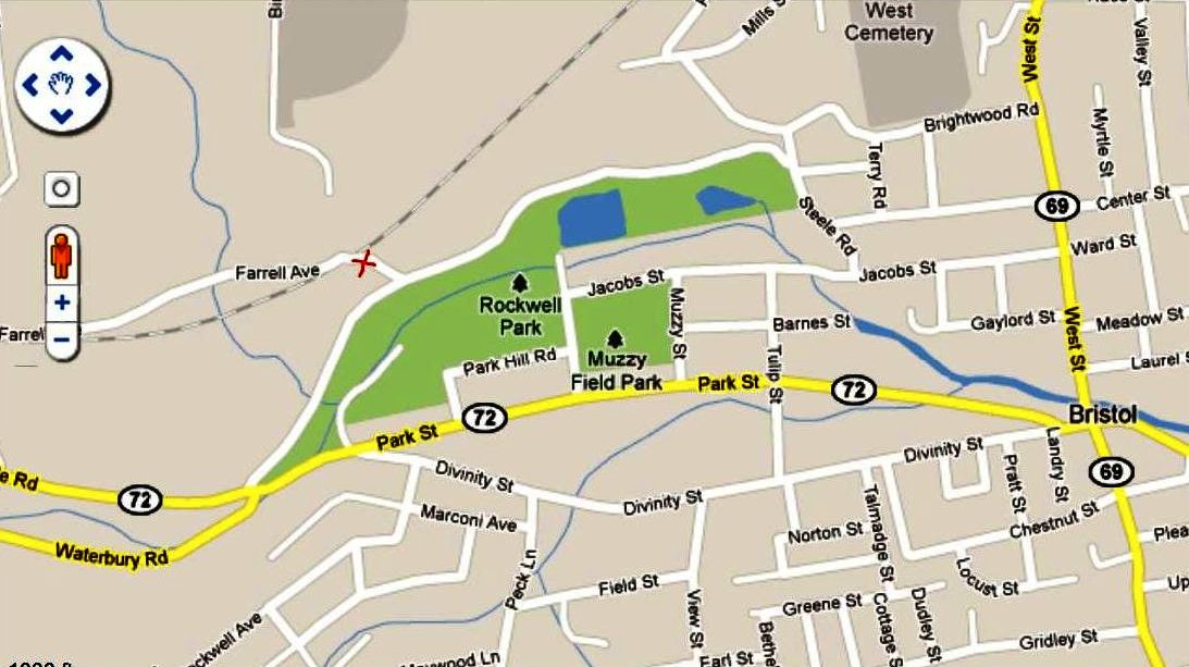
|
BRISTOL PARK [NY&NE, 1887]
This was a minor, seasonal, and probably short-lived stop created in 1887 by the NY&NE for the new fairgrounds of the Bristol Park Association. They had taken over the Hickory Park property from the earlier Pequabuck Association who had started running an agricultural fair back in 1865. Speculation was that the revived effort was to see the railroad run a 600-ft spur into the park to deliver the animals as well as the fair-goers, but we do not see any evidence that this was done. Several newspaper articles refer to a 'fair station' from which the attendees could walk the short distance and cross the bridge over the Pequabuck River to enter the fairgrounds. We have put the red X at the likely spot for the station on all three maps, dated from left to right, 1893, 1940, and 2011. We are not sure exactly how long the fair and the horse racing that was a part of the activities lasted but Hickory Park was sold to A.J. Muzzy, a successful Bristol merchant, in 1900 and it was turned into housing lots with the adjacent Muzzy Field retained for public use. In 1914, land to the north was donated by Bristol industrialist A.J. Rockwell for Bristol's first public park. In an iconic American corporate success story, his New Departure company [click here] would start out making doorbells in 1888 and progress to bicycle components, ball-bearing products, and even taxi cabs and automobiles. Rockwell Park received an NRHP designation in 1987 [click here] and still serves the public today. Although tangential to the park, the agricultural-fair history of the land in this area is not noted at all in the NRHP nomination research. [REFS: HDC/10/10/1867/04; HDC/05/16/1887/04; HDC/09/26/1887/05; HC?09/24/1888/08; BP/08/23/1900/ 01; HC/02/24/1916/11][rrd121816]
This was a minor, seasonal, and probably short-lived stop created in 1887 by the NY&NE for the new fairgrounds of the Bristol Park Association. They had taken over the Hickory Park property from the earlier Pequabuck Association who had started running an agricultural fair back in 1865. Speculation was that the revived effort was to see the railroad run a 600-ft spur into the park to deliver the animals as well as the fair-goers, but we do not see any evidence that this was done. Several newspaper articles refer to a 'fair station' from which the attendees could walk the short distance and cross the bridge over the Pequabuck River to enter the fairgrounds. We have put the red X at the likely spot for the station on all three maps, dated from left to right, 1893, 1940, and 2011. We are not sure exactly how long the fair and the horse racing that was a part of the activities lasted but Hickory Park was sold to A.J. Muzzy, a successful Bristol merchant, in 1900 and it was turned into housing lots with the adjacent Muzzy Field retained for public use. In 1914, land to the north was donated by Bristol industrialist A.J. Rockwell for Bristol's first public park. In an iconic American corporate success story, his New Departure company [click here] would start out making doorbells in 1888 and progress to bicycle components, ball-bearing products, and even taxi cabs and automobiles. Rockwell Park received an NRHP designation in 1987 [click here] and still serves the public today. Although tangential to the park, the agricultural-fair history of the land in this area is not noted at all in the NRHP nomination research. [REFS: HDC/10/10/1867/04; HDC/05/16/1887/04; HDC/09/26/1887/05; HC?09/24/1888/08; BP/08/23/1900/ 01; HC/02/24/1916/11][rrd121816]

|

|
BROAD BROOK1 [CC, 1876]
This stop is in the town of East Windsor. We can't be completely sure but this depot seems smaller to us and we have put this image here as being of the first station. The dating of the bird's-eye map is said to be between 1876 and 1880, the former date coinciding with the opening of the Connecticut Central RR whose train is coming into the station from the south. The station is clearly shown on the west side of the track. To our surprise, the 1893 Hurd map places the depot on the east side of the track. Is the mapmaker in error or the bird's-eye map artist or are both correct and there were two different stations here, a situation complicated by the fact that the val map in our next entry shows the station back on the west side of the track. For now, we are assuming that the 1893 mapmaker got it wrong. [rrd121816]
This stop is in the town of East Windsor. We can't be completely sure but this depot seems smaller to us and we have put this image here as being of the first station. The dating of the bird's-eye map is said to be between 1876 and 1880, the former date coinciding with the opening of the Connecticut Central RR whose train is coming into the station from the south. The station is clearly shown on the west side of the track. To our surprise, the 1893 Hurd map places the depot on the east side of the track. Is the mapmaker in error or the bird's-eye map artist or are both correct and there were two different stations here, a situation complicated by the fact that the val map in our next entry shows the station back on the west side of the track. For now, we are assuming that the 1893 mapmaker got it wrong. [rrd121816]

|
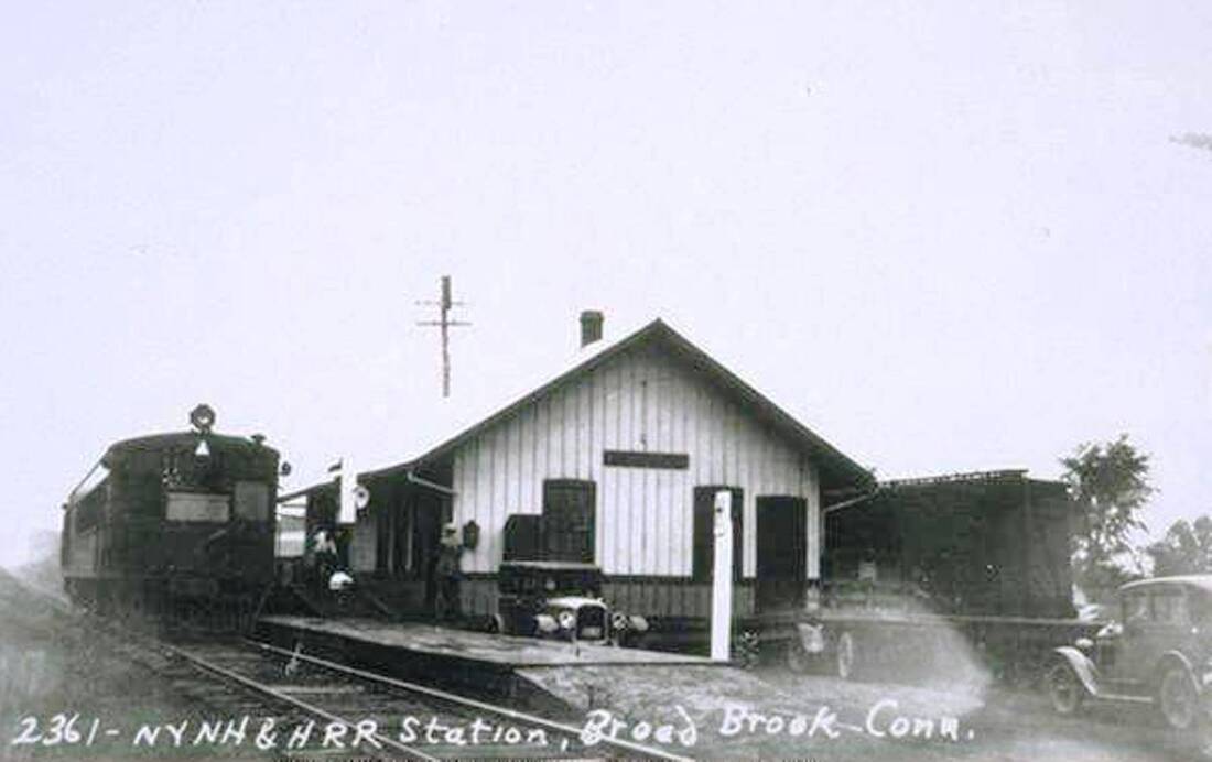
|

|
BROAD BROOK2 [NYNH&H, c1900?]
The 1915 val map shows the arrangement of the station grounds and adjacent area at that time, the depot being on the west side of the track. The middle photo is Lewis H. Benton #2361 taken in 1929; Irving Drake's sedan in view at right. A gas-electric car was handling a mail sack at the time of the duo's visit. Both photos look south. If this, in fact, is a station subsequent to 1876, we do not have a build date. [rev121816]
The 1915 val map shows the arrangement of the station grounds and adjacent area at that time, the depot being on the west side of the track. The middle photo is Lewis H. Benton #2361 taken in 1929; Irving Drake's sedan in view at right. A gas-electric car was handling a mail sack at the time of the duo's visit. Both photos look south. If this, in fact, is a station subsequent to 1876, we do not have a build date. [rev121816]
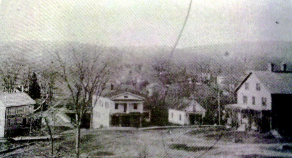
|

|
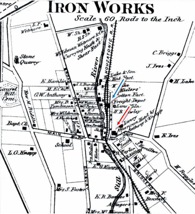
|
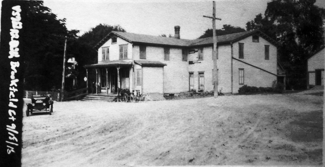
BROOKFIELD1 [HRR, 1840]
Upon reconsideration of the evidence, we are now thinking that the first passenger station in this town was in the American Hotel, on the east side of the tracks. This establishment, operated by Anthony S. Knapp in 1867, was already a landmark by that time and lasted into the next century. This Iron Works District stop was said to have handled mostly freight but there also had to be passenger service here from the start of the HRR in 1840 as it appears on the earliest timetables. The hotel-station arrangement is borne out in the 1864 Courant article that said "A fire, which took in a store in Knapp's hotel building, Brookfield, Thursday night, communicated to the railroad, telegraph and post offices in the same building, doing quite extensive damage. -- Building saved." It was not unusual for early HRR stations to be in hotels; we have confirmed instances elsewhere with MERWINSVILLE1, CANAAN1, and possibly STEPNEY1. Also supporting the hotel as station is the fact that neither the 1856FC map at [2] nor the 1867 Beers map at [3] indicate any actual passenger depot. Both show Knapp's American Hotel [red arrow] and the latter also shows the freight depot [blue arrow] just up the track. In the photo at [1], the hotel is the large building in the extreme right. Shorn of its third floor perhaps after the 1864 fire, the railroad must have purchased it at some point since it is seen as NYNH&H property in the 9/18/1916 val photo at [4]. [REFS: HDC/03/28/1864/01][rev122217]
Upon reconsideration of the evidence, we are now thinking that the first passenger station in this town was in the American Hotel, on the east side of the tracks. This establishment, operated by Anthony S. Knapp in 1867, was already a landmark by that time and lasted into the next century. This Iron Works District stop was said to have handled mostly freight but there also had to be passenger service here from the start of the HRR in 1840 as it appears on the earliest timetables. The hotel-station arrangement is borne out in the 1864 Courant article that said "A fire, which took in a store in Knapp's hotel building, Brookfield, Thursday night, communicated to the railroad, telegraph and post offices in the same building, doing quite extensive damage. -- Building saved." It was not unusual for early HRR stations to be in hotels; we have confirmed instances elsewhere with MERWINSVILLE1, CANAAN1, and possibly STEPNEY1. Also supporting the hotel as station is the fact that neither the 1856FC map at [2] nor the 1867 Beers map at [3] indicate any actual passenger depot. Both show Knapp's American Hotel [red arrow] and the latter also shows the freight depot [blue arrow] just up the track. In the photo at [1], the hotel is the large building in the extreme right. Shorn of its third floor perhaps after the 1864 fire, the railroad must have purchased it at some point since it is seen as NYNH&H property in the 9/18/1916 val photo at [4]. [REFS: HDC/03/28/1864/01][rev122217]
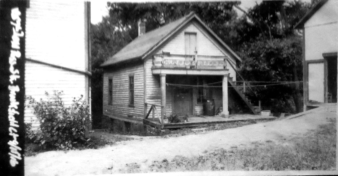
|
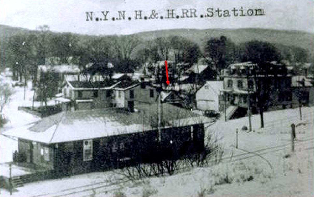
|
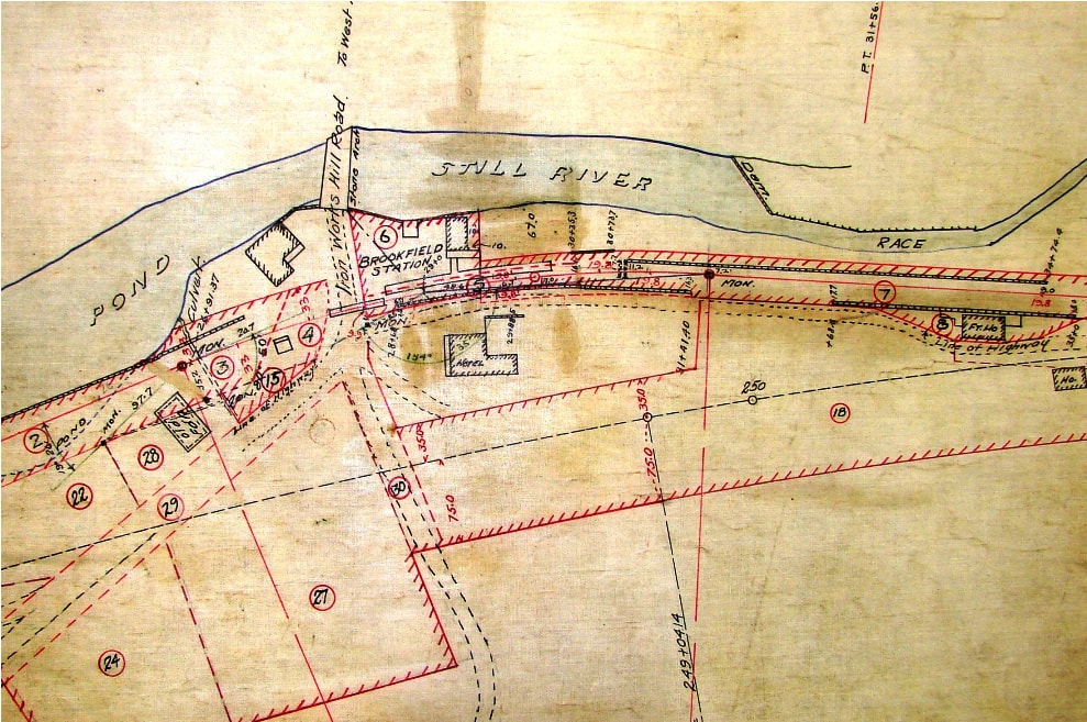
|
BROOKFIELD2 [HRR, 1869?]
Store-like in appearance, this structure was for many years erroneously considered to be the first station in this town. Various undocumented sources claim that this structure was destroyed by fire and/or was later sold to the Brookfield Iron Works. Foldered R&LHS material at the Baker Library includes a 6/22/1887 statement that shows this building as privately owned by Henry S. Beers who was being paid $5 per month rental for use of it as a passenger depot. However these factors play into the history of the structure, it is seen at [1] still standing and as railroad property in a 9/15/1916 val photo, out of service after BROOKFIELD3 was built but still sporting its old signboard. In the shot at [2] it is seen at the red arrow behind BROOKFIELD3. The 1912 real estate map at [3] shows this station still in place before the track changes that would abandon about a half mile of the old HRR in favor ot the new double-tracked alignment. [REFS: RRC6.11 (5/16/1868: depot repairs); B891] [rev122217]
Store-like in appearance, this structure was for many years erroneously considered to be the first station in this town. Various undocumented sources claim that this structure was destroyed by fire and/or was later sold to the Brookfield Iron Works. Foldered R&LHS material at the Baker Library includes a 6/22/1887 statement that shows this building as privately owned by Henry S. Beers who was being paid $5 per month rental for use of it as a passenger depot. However these factors play into the history of the structure, it is seen at [1] still standing and as railroad property in a 9/15/1916 val photo, out of service after BROOKFIELD3 was built but still sporting its old signboard. In the shot at [2] it is seen at the red arrow behind BROOKFIELD3. The 1912 real estate map at [3] shows this station still in place before the track changes that would abandon about a half mile of the old HRR in favor ot the new double-tracked alignment. [REFS: RRC6.11 (5/16/1868: depot repairs); B891] [rev122217]
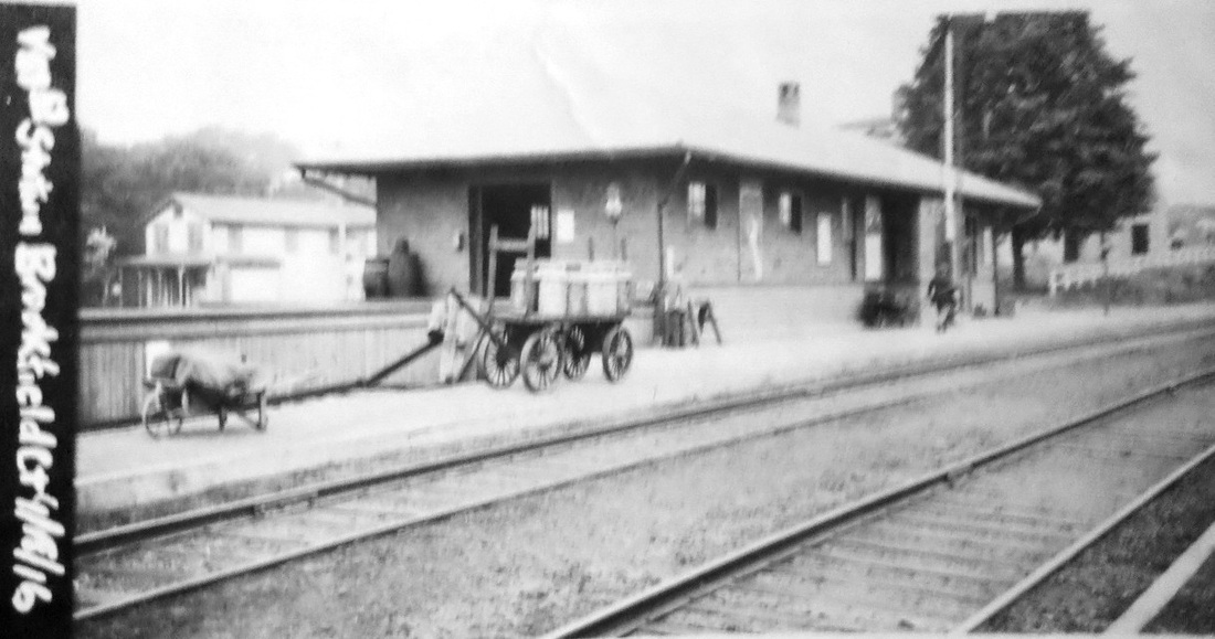
|
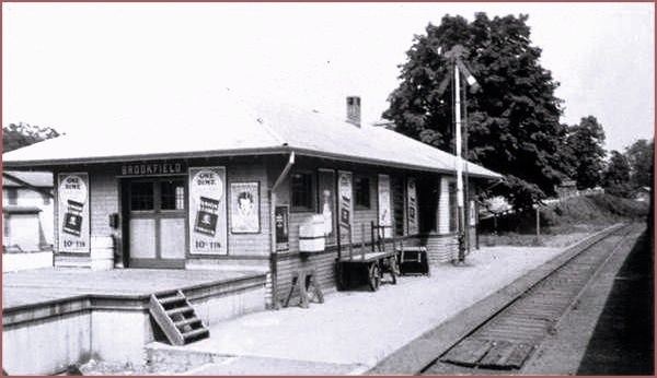
|
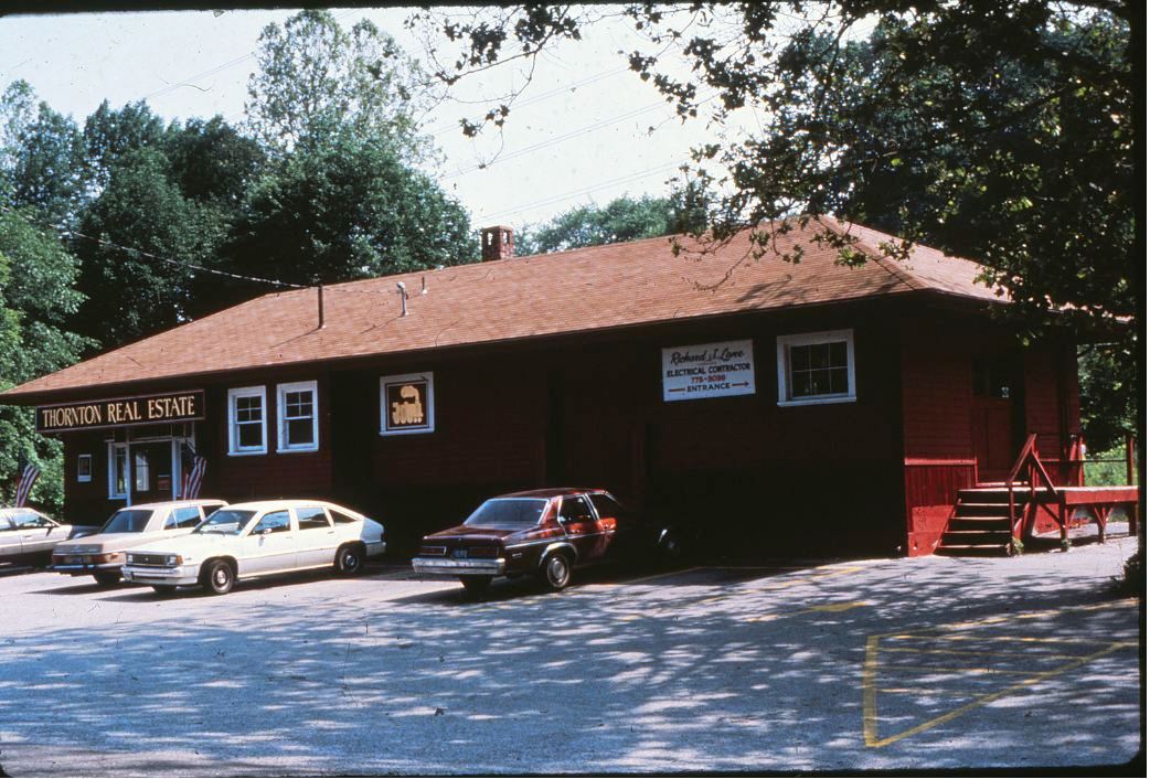
|
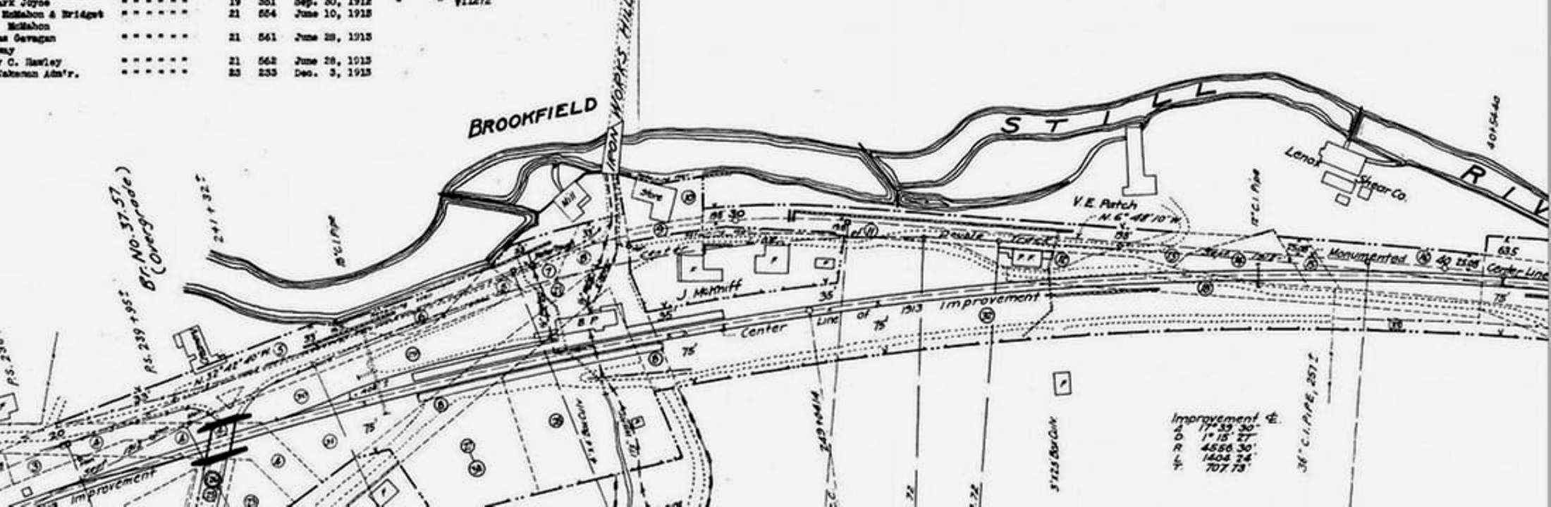
BROOKFIELD3 [NYNH&H, 1914]
The Courant reported in 1913 that the new station here was to be built about 50 feet east of the old location on the newly aligned, double-tracked right of way. The Danbury News said late in the year that "a temporary passenger station, freight house and car for handling milk shipments at that place are located on the west side of the track," presumably adjacent to where BROOKFIELD3 was being built. While no actual opening date has yet been found in the newspapers, the 1914 annual report said completion was expected in the fall of that year and the following report said that the new passenger station was in service. BROOKFIELD3 has been a real estate office and part of the Brookfield Craft Center since leaving railroad service. It still stands today as trains of the reincarnated HRR rumble by. [REFS: HC/03/14/1913/03; HC/08/07/1913/03; DN/12/03/1913/04; NHAR43.1914.21; NHAR44.1915.10; R37][rrd122217]
The Courant reported in 1913 that the new station here was to be built about 50 feet east of the old location on the newly aligned, double-tracked right of way. The Danbury News said late in the year that "a temporary passenger station, freight house and car for handling milk shipments at that place are located on the west side of the track," presumably adjacent to where BROOKFIELD3 was being built. While no actual opening date has yet been found in the newspapers, the 1914 annual report said completion was expected in the fall of that year and the following report said that the new passenger station was in service. BROOKFIELD3 has been a real estate office and part of the Brookfield Craft Center since leaving railroad service. It still stands today as trains of the reincarnated HRR rumble by. [REFS: HC/03/14/1913/03; HC/08/07/1913/03; DN/12/03/1913/04; NHAR43.1914.21; NHAR44.1915.10; R37][rrd122217]

|

|
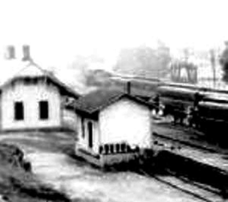
|
BROOKFIELD JUNCTION1 [HRR, 1868]
According to the venerable Newtown Bee, this structure was to be "moved to the west, across the branch... [to] serve as a freight depot" when DANBURY4 was brought here in 1889. We have long wondered whether, in fact, the smaller structure was the older station that was brought down from Stockbridge, MA by the HRR late in 1869 and reassembled here for the use of both the HRR and the NYH&N. It was said to measure 13x30 feet and this diminutive structure seems likely to be the long-lost BROOKFIELD JUNCTION1. See Track 9 and Track 10, MP 10.2.7 for more. Confusing the issue, however, the Danbury Times said the HRR was intending to move the old 20x50-ft Pittsfield depot here upon the opening of the new union station there late in 1869 and an 1870 article in the Springfield Republican says "The old Housatonic depot at Pittsfield has been taken down and removed to Brookfield, Ct., where it will continue to do duty as a passenger house for the Housatonic railroad. We think that means here at the junction. Whatever the origin, this depot was undersized for an agency station at an important junction. An 1888 article speaks of a rain storm in which the "little station house was so crowded that occupants could not turn their heads(!)" The arrival of the next depot, which was brought up from Danbury, must have been quite a relief to the station agent. [REFS: PS/08/12/1869/02,03: Pittsfield; DT/10/07/1869/02: Pittsfield to Brookfield, junction not specified, 20x50; DT/11/18/1869/02: Stockbridge; DT/12/02/1869/03: origin not specified, junction, 13x30; SR/01/17/1870/08: Pitttsfield; DEN/12/02/1887/03: agent, office, robbery; DEN/10/08/1888/03; NBE/04/05/1889/02: lost; NBE/1905/07/25/02: depot moved from west to east side of track][rev121816]
According to the venerable Newtown Bee, this structure was to be "moved to the west, across the branch... [to] serve as a freight depot" when DANBURY4 was brought here in 1889. We have long wondered whether, in fact, the smaller structure was the older station that was brought down from Stockbridge, MA by the HRR late in 1869 and reassembled here for the use of both the HRR and the NYH&N. It was said to measure 13x30 feet and this diminutive structure seems likely to be the long-lost BROOKFIELD JUNCTION1. See Track 9 and Track 10, MP 10.2.7 for more. Confusing the issue, however, the Danbury Times said the HRR was intending to move the old 20x50-ft Pittsfield depot here upon the opening of the new union station there late in 1869 and an 1870 article in the Springfield Republican says "The old Housatonic depot at Pittsfield has been taken down and removed to Brookfield, Ct., where it will continue to do duty as a passenger house for the Housatonic railroad. We think that means here at the junction. Whatever the origin, this depot was undersized for an agency station at an important junction. An 1888 article speaks of a rain storm in which the "little station house was so crowded that occupants could not turn their heads(!)" The arrival of the next depot, which was brought up from Danbury, must have been quite a relief to the station agent. [REFS: PS/08/12/1869/02,03: Pittsfield; DT/10/07/1869/02: Pittsfield to Brookfield, junction not specified, 20x50; DT/11/18/1869/02: Stockbridge; DT/12/02/1869/03: origin not specified, junction, 13x30; SR/01/17/1870/08: Pitttsfield; DEN/12/02/1887/03: agent, office, robbery; DEN/10/08/1888/03; NBE/04/05/1889/02: lost; NBE/1905/07/25/02: depot moved from west to east side of track][rev121816]
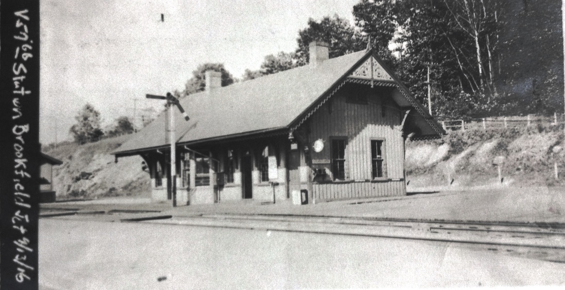
ICC Collection/National Archives
|
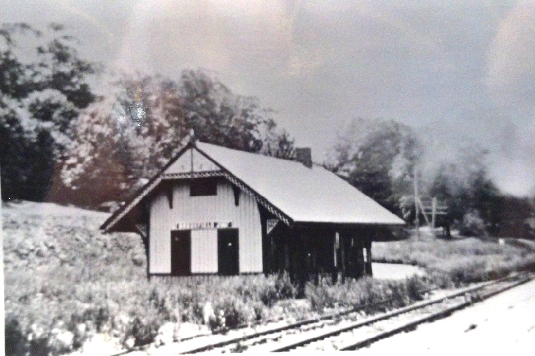
McCoid/Wooding Collection
|
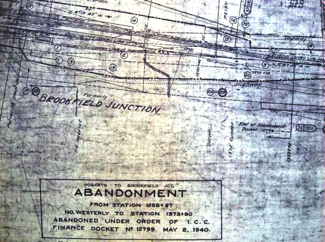
|
BROOKFIELD JUNCTION2 [HRR, 1889]
This structure was built as DANBURY4 in 1886 and was moved here early on 3/17/1889 to replace the first station, which was used thereafter as the freight depot. See Track 9 and Track 10, MP 10.6.5 for more. The Newtown Bee tells us on 4/5 that "work on the depot at Brookfield Junction is progressing rapidly and it is now in the hands of painters. The building has been placed on a new foundation, south of the former site and the passenger platform extended 100 feet to the south. A wide platform has also been built between the main track and the branch for transferring baggage. The old passenger depot will be moved to the west, across the branch and will serve as a freight depot." Our only quibble with this might be the direction, which would seem to be to the east. The middle photo shows the depot closed but with signboard still in place perhaps ca. 1932; passenger service ended here in 1925. The actual fate and the end date for this structure is not yet known but it does not appear on any of our 1938-1940 retirement lists so presumably it was sold or demolished before then. The map at [3] for ICC abandonment docket 12799 is dated 5/2/1940 and appears to say 'Foundation' in the upper left corner where the station stood. [REFS: NBE/04/05/1889/04][rev122317]
This structure was built as DANBURY4 in 1886 and was moved here early on 3/17/1889 to replace the first station, which was used thereafter as the freight depot. See Track 9 and Track 10, MP 10.6.5 for more. The Newtown Bee tells us on 4/5 that "work on the depot at Brookfield Junction is progressing rapidly and it is now in the hands of painters. The building has been placed on a new foundation, south of the former site and the passenger platform extended 100 feet to the south. A wide platform has also been built between the main track and the branch for transferring baggage. The old passenger depot will be moved to the west, across the branch and will serve as a freight depot." Our only quibble with this might be the direction, which would seem to be to the east. The middle photo shows the depot closed but with signboard still in place perhaps ca. 1932; passenger service ended here in 1925. The actual fate and the end date for this structure is not yet known but it does not appear on any of our 1938-1940 retirement lists so presumably it was sold or demolished before then. The map at [3] for ICC abandonment docket 12799 is dated 5/2/1940 and appears to say 'Foundation' in the upper left corner where the station stood. [REFS: NBE/04/05/1889/04][rev122317]
BROOKS/CHESHIRE [> BROOKSVALE]
BROOKS/COLEBROOK [> COLEBROOK]
BROOKS/COLEBROOK [> COLEBROOK]

|

|

|
BROOKSIDE PARK [D&N, 1880]
This stop was virtually synonomous with REDDING, but we have chosen to list it separately because of its own history and identity. While some sources say it was about a half mile south, these 1911 real estate maps show the access point to the park on the easterly side of the D&N to be a few hundred feet from REDDING2. Traversed by the Saugatuck River crossed on a bridge just in from the entrance, this 25-acre parcel appears to have been a camp meeting ground going back at least to 1851 when the newspaper said that "a Camp Meeting will be held near the Norwalk road [D&N], in Ridgefield, one mile west of the Methodist church, commencing Monday, Sept. 1st." Though the Register foreshadowed the creation of the railroad park in 1874, the railroad commissioners say it was in 1880 when the D&N "ventured the experiment of purchasing and fitting up in an attractive manner a grove on the line of its road at Reading [sic] station," similar to HIGH ROCK GROVE or PARLOR ROCK, which were also newly opening at this time. In 1881, the Register called it a "fortunate hit" for the railroad, recouping $8,000 of the $12,000 expended in just two years of operation, and the commissioners added that the railroad was making money here "being mostly done on regular trains, and causing but little addition to its ordinary operating expenses." With its commanding views and amenities, the pavilion was said in 1882 to be capable of accommodating 3,000 worshippers. Obviously, there was money to be made in what the commissioners called "The Excursion Business" in 1880, the new phenomenon in this country of railroad tourism to recreational destinations that had already been proven profitable abroad. Apparently, the NYNH&H carried on the tradition at this location at least until 1899 when the last newspaper item we have found said that Connecticut Sunday School Association held a rally here. In 1905, The Hour of Norwalk reported that the railroad had sold the pavilion "to parties who will remove it to Lake Kenoshia" in Danbury. The park property still appears intact on the 1911 maps and on the 1915 val map [click here], as well. Cornwall said in a 1986 Shoreliner that two granite pillars still marked the entrance across the road from the REDDING2 at that time, presumably at the Passageway seen on the map, and Brent Colley's History of Redding website [click here], says the columns are still there today in 2011. Although possible, it seems unlikely there was any separate BROOKSIDE PARK depot south of the entrance gate seen in the postcard. [REFS: CR/08/30/1851/03; NHER/08/21/1874/02; NHDP/07/31/1878 /02; NHER/12/09/1881/04; CRC27.1880.11; CRC28.1881.14; NHER/08/11/1882/04; NHER/07/21/1883/02; NHER/08/20/1885/04; NHER/09/01/1899/10; NH/05/18/1905/03; SL17.4.26][rev071615]
This stop was virtually synonomous with REDDING, but we have chosen to list it separately because of its own history and identity. While some sources say it was about a half mile south, these 1911 real estate maps show the access point to the park on the easterly side of the D&N to be a few hundred feet from REDDING2. Traversed by the Saugatuck River crossed on a bridge just in from the entrance, this 25-acre parcel appears to have been a camp meeting ground going back at least to 1851 when the newspaper said that "a Camp Meeting will be held near the Norwalk road [D&N], in Ridgefield, one mile west of the Methodist church, commencing Monday, Sept. 1st." Though the Register foreshadowed the creation of the railroad park in 1874, the railroad commissioners say it was in 1880 when the D&N "ventured the experiment of purchasing and fitting up in an attractive manner a grove on the line of its road at Reading [sic] station," similar to HIGH ROCK GROVE or PARLOR ROCK, which were also newly opening at this time. In 1881, the Register called it a "fortunate hit" for the railroad, recouping $8,000 of the $12,000 expended in just two years of operation, and the commissioners added that the railroad was making money here "being mostly done on regular trains, and causing but little addition to its ordinary operating expenses." With its commanding views and amenities, the pavilion was said in 1882 to be capable of accommodating 3,000 worshippers. Obviously, there was money to be made in what the commissioners called "The Excursion Business" in 1880, the new phenomenon in this country of railroad tourism to recreational destinations that had already been proven profitable abroad. Apparently, the NYNH&H carried on the tradition at this location at least until 1899 when the last newspaper item we have found said that Connecticut Sunday School Association held a rally here. In 1905, The Hour of Norwalk reported that the railroad had sold the pavilion "to parties who will remove it to Lake Kenoshia" in Danbury. The park property still appears intact on the 1911 maps and on the 1915 val map [click here], as well. Cornwall said in a 1986 Shoreliner that two granite pillars still marked the entrance across the road from the REDDING2 at that time, presumably at the Passageway seen on the map, and Brent Colley's History of Redding website [click here], says the columns are still there today in 2011. Although possible, it seems unlikely there was any separate BROOKSIDE PARK depot south of the entrance gate seen in the postcard. [REFS: CR/08/30/1851/03; NHER/08/21/1874/02; NHDP/07/31/1878 /02; NHER/12/09/1881/04; CRC27.1880.11; CRC28.1881.14; NHER/08/11/1882/04; NHER/07/21/1883/02; NHER/08/20/1885/04; NHER/09/01/1899/10; NH/05/18/1905/03; SL17.4.26][rev071615]
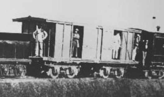
|
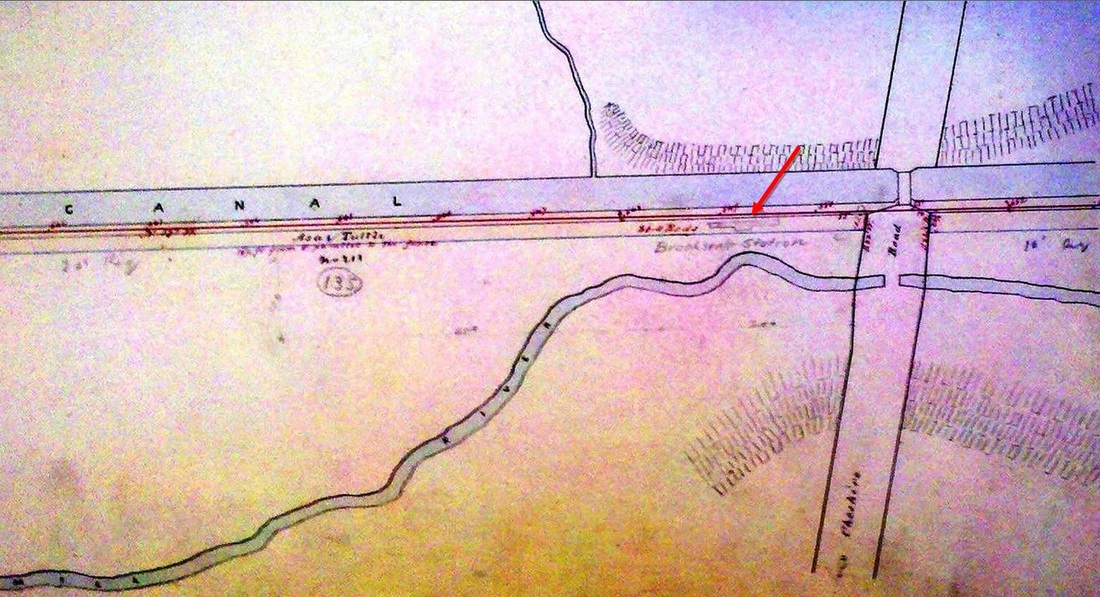
|
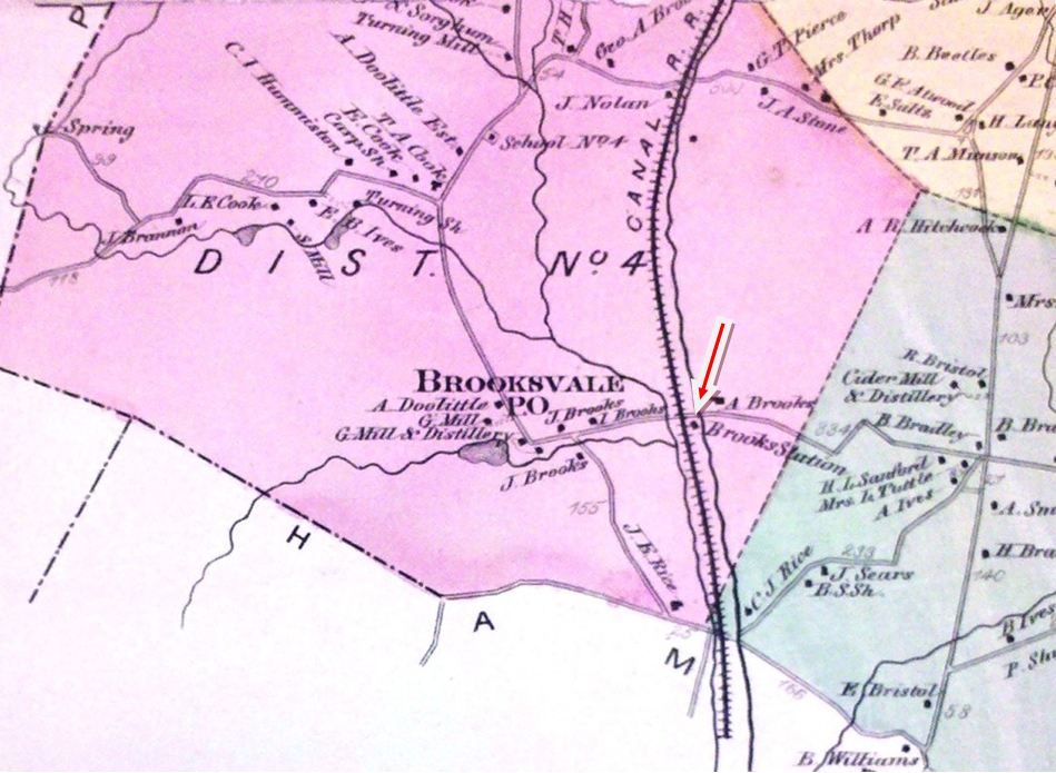
|
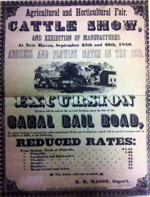
BROOKSVALE1
[NH&N, 1848; opens as BROOKS STATION]
The Cheshire Historical Society has a copy of a document which reads in part that "When the Railroad went through the Brooks Farm, it was stipulated there would be a station and a mail-arm at the road crossing." The NY&NH leased the Canal line on 6/1/1848 and, following said stipulation, built a freight platform and assigned "an old baggage-car which served as a shelter for passengers waiting at the station... soon after taking possession of said road." Seen on the 1850 station list at [4], this stop was 12 miles up from Long Wharf and three miles below Cheshire. The first newspaper reference is in an 1858 fire at Julius Brooks's "extensive oyster keg manufactory" near "Brook's Station, on the Canal Road, in West Cheshire..." and an 1869 article mentions this as a junction point for the earliest incarnation of the MW&CR from Meriden to Waterbury. That railroad was to cross well to the north when built in 1888: see CHESHIRE JUNCTION. One month after the lease expired on 7/1/1869, the NH&N summarily abandoned this stop and initiated proceedings to close other less-used ones, e.g. IVES, ALLENS, on various legal grounds. Locals sued and were upheld in the courts, based on the fact that, albeit with no agent, freight was handled both ways, mail was delivered regularly and passenger tickets were sold from elsewhere to BROOKS STATION for 21 years. As it is not seen on a Register fare list in 1872, it is likely that the NH&N stonewalled until the railroad commissioners approved formal abandonment as of 6/2/1874. A September, 1874 Palladium article indicates, however, that this structure (or the subsequent one in our next listing) was in place at that time and sizeable enough for the Rev. Dr. Horton of Cheshire Academy to speak there "to an interested audience." The 1855 car seen at [1] may look like the first station, though that one was said to be only 12 feet long; we assume it was removed by the railroad ca. 1875. The 1848 NH&N real estate atlas at [2] may well show the footprint of the car and the 1868 map at [3] shows the location on the east side of the track. [REFS: 1851TT; 1858TT; 1858GED yes; HDC/02/26/1858/02; HDC/09/10/1860/02; CR/05/08/1869/04; SR/10/06/1869/05; WDA/10/06/1869/03; CR/11/20/1869/02; CR/01/01/1870/03; 37 Conn. 153, 157, (1870); HDC/07/09/1870/01; HDC/07/16/1870/01; HDC/04/22/1872/04; CR/06/08/1872/03; NHDP/09/16/1874/04; NHNAR38.1874.4; RRC9.4,24.200 (6/2/1874] [rev011015, 051022]
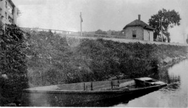
|
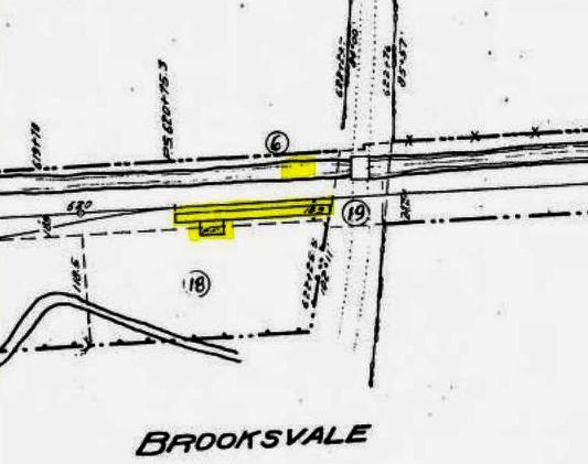
|
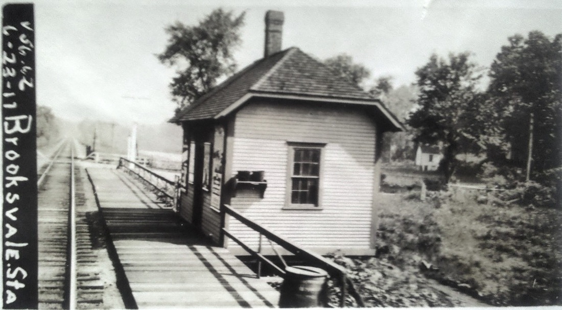
|

BROOKSVALE2 [NYNH&H, c1876]
According to the Connecticut Historical Society's Edwin R. Brown Manuscript, dated 1886-1888, "East of railroad track on south side of road near the track, the people of Brooks Vale built a depot some 10 years ago... [and] ... after the neat little building was finished, however, the R.R. Company refused to accede to the people's wishes..." It is interesting that locals here persisted in their quest for railroad service much like PLANTSVILLE. The 10-year vagary may mean that the new station was built as early as 1874, more or less as a last-ditch effort to save the stop. Spurned by the railroad, however, it was used for other purposes, including Sabbath-day lectures as before. Shortly after the NYNH&H leased the Canal line for a second time on 4/1/1887, the new name BROOKSVALE appears on maps and public timetables, 11.97 miles north of New Haven. An 1888 article about a local wedding said that "the Canal road had two special car-loads of guests for Brooksvale" on the 4:00 train from New Haven, implying that passengers disembarked here. Interestingly, the 1895 charter of the Cheshire Street Railway gives it the right to build from the WEST CHESHIRE MW&CR station to "the Brooksvale station on the Northampton division of the New York, New Haven & Hartford railroad." The ca. 1900 photo [1] with the rowboat looks southeast and shows in the foreground the railing for the highway bridge over the canal segment that endures even today. We have highlighted the station and platform and the boat location on the 1915 val map [2]. The vessel was owned by Thayer teenagers, Gordon and Thornton (born 1886, 1890). The former was quoted in a 1964 Register article as remembering how mail was thrown off the train from New York at 8:20 a.m. and locals would have their newspapers by 9:00 a.m. Thayer recalled further how “the eastbound train snatched the mail pouch from the metal arm" and that "it was possible to have a reply to a letter received in the early mail back in New York City the same day." The Brooksvale post office, with Edwin M. Brooks as postmaster, was established in 1858 and it was discontinued on March 31, 1913. The ICC valuation photo at [3] is dated 6/23/1917. Passenger service on the Canal line was converted to NYNH&H subsidiary NETCo buses by February, 1926. The PUC photo at [4] shows BROOKSVALE2 on 10/23/1925. At some point afterward, the structure was reportedly sold to the Thayer family who moved it to their property. Many thanks to Christine Pittsley, avid Cheshire history researcher, for the Brown manuscript reference! [REFS: HDC/10/23/1858/02; CR/04/01/1876/02: washout; RRM1876-1912: no; 1879GHD: no; NHER/03/21/1891/03; NHER/03/25/ 1891/03; 1/15/1888ETT: no; E.R. Brown, CHS MSS 43702, 1886-1888, p99; 1890TT: yes; Conn. Spec. Law 323 (1895); RAM1904+: yes][rev011015, 051022; 021823]
According to the Connecticut Historical Society's Edwin R. Brown Manuscript, dated 1886-1888, "East of railroad track on south side of road near the track, the people of Brooks Vale built a depot some 10 years ago... [and] ... after the neat little building was finished, however, the R.R. Company refused to accede to the people's wishes..." It is interesting that locals here persisted in their quest for railroad service much like PLANTSVILLE. The 10-year vagary may mean that the new station was built as early as 1874, more or less as a last-ditch effort to save the stop. Spurned by the railroad, however, it was used for other purposes, including Sabbath-day lectures as before. Shortly after the NYNH&H leased the Canal line for a second time on 4/1/1887, the new name BROOKSVALE appears on maps and public timetables, 11.97 miles north of New Haven. An 1888 article about a local wedding said that "the Canal road had two special car-loads of guests for Brooksvale" on the 4:00 train from New Haven, implying that passengers disembarked here. Interestingly, the 1895 charter of the Cheshire Street Railway gives it the right to build from the WEST CHESHIRE MW&CR station to "the Brooksvale station on the Northampton division of the New York, New Haven & Hartford railroad." The ca. 1900 photo [1] with the rowboat looks southeast and shows in the foreground the railing for the highway bridge over the canal segment that endures even today. We have highlighted the station and platform and the boat location on the 1915 val map [2]. The vessel was owned by Thayer teenagers, Gordon and Thornton (born 1886, 1890). The former was quoted in a 1964 Register article as remembering how mail was thrown off the train from New York at 8:20 a.m. and locals would have their newspapers by 9:00 a.m. Thayer recalled further how “the eastbound train snatched the mail pouch from the metal arm" and that "it was possible to have a reply to a letter received in the early mail back in New York City the same day." The Brooksvale post office, with Edwin M. Brooks as postmaster, was established in 1858 and it was discontinued on March 31, 1913. The ICC valuation photo at [3] is dated 6/23/1917. Passenger service on the Canal line was converted to NYNH&H subsidiary NETCo buses by February, 1926. The PUC photo at [4] shows BROOKSVALE2 on 10/23/1925. At some point afterward, the structure was reportedly sold to the Thayer family who moved it to their property. Many thanks to Christine Pittsley, avid Cheshire history researcher, for the Brown manuscript reference! [REFS: HDC/10/23/1858/02; CR/04/01/1876/02: washout; RRM1876-1912: no; 1879GHD: no; NHER/03/21/1891/03; NHER/03/25/ 1891/03; 1/15/1888ETT: no; E.R. Brown, CHS MSS 43702, 1886-1888, p99; 1890TT: yes; Conn. Spec. Law 323 (1895); RAM1904+: yes][rev011015, 051022; 021823]
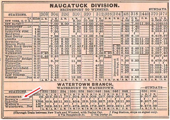
|
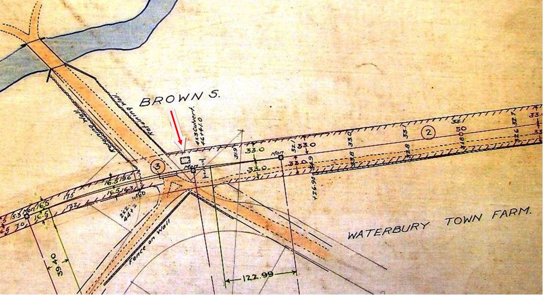
|
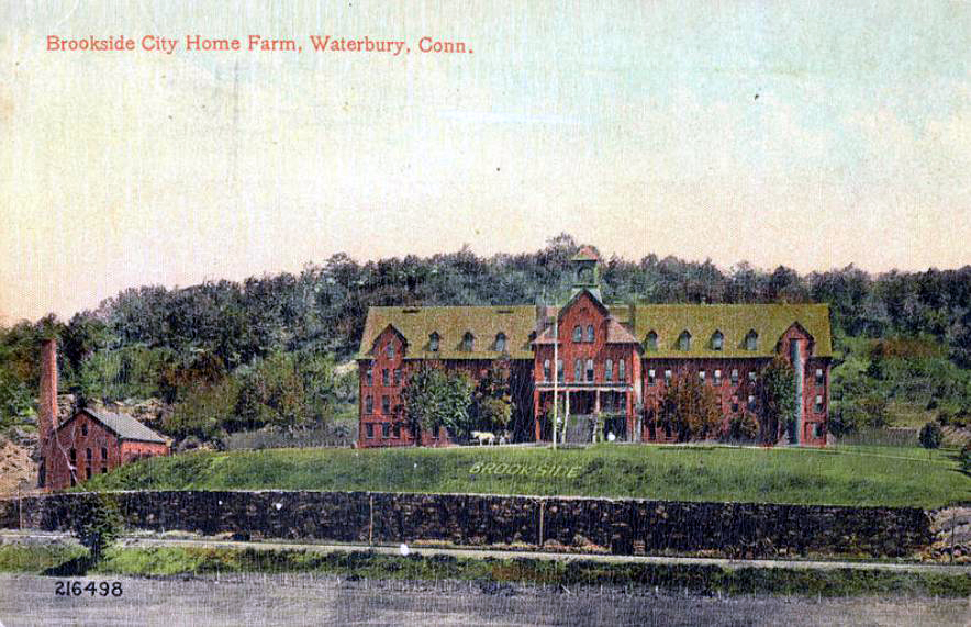
|
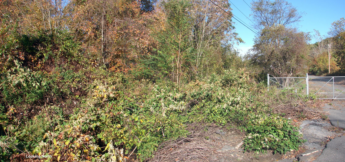
|
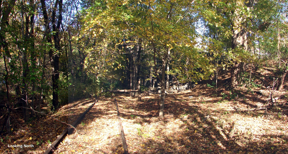
|
|
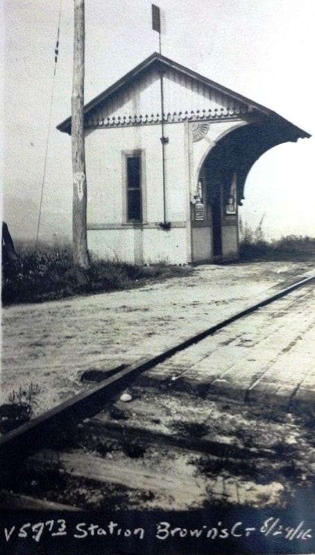
BROWNS [NYNH&H, c1898]
This was a stop in the town of Waterbury on the Watertown branch, the former W&W. Though no passenger is seen waiting, the flag is up in the 8/29/1916 val photo at [7]. The station makes its first appearance on the rev07/19/1898TT seen at [1] and lasted through our 12/2/1923TT and probably until passenger service ended on the branch around 1925. According to Henry P. Stearns's 1980 Shoreliner article, it was located in far northeast Waterbury just below the Brookside Home, the social services facility that once stood near Waterbury's Municipal Stadium. Various maps show the station sat in the northwest quadrant of the crossing at Huntingdon Ave. The home was probably built on the site of the old Waterbury town farm, the almshouse, as shown on the 1912 NYNH&H real estate map at [2]. That institution dated back to 1839 and in 1870 was permitted to give up some of its land for the W&W, which is seen in passing in front of the property in the card at [3]. The style of the shed matches others on the NRR at REYNOLDS BRIDGE and WELTONS, the latter being farther up the branch. The shots at [4] and [5] were taken in 2011; track was still in the ground running north from the station site. According to a Courant article, a new station was to be built here a half mile south of the old one in 1918 but we do not know why or if it was in fact ever built. The new location would have been at East Aurora St.; the stub-ended Watertown Branch still serves a scrap dealer today just short of that street. Our Track 12 GE map at [6] shows the location today. As a result of this review, we have de-listed BROWNS2. [REFS: 1894TT: no; 1896TT: no; CWN/10/26/1899/03; HC/07/20/1918/03; D99; K63; SL11.2.24][rev122217]
This was a stop in the town of Waterbury on the Watertown branch, the former W&W. Though no passenger is seen waiting, the flag is up in the 8/29/1916 val photo at [7]. The station makes its first appearance on the rev07/19/1898TT seen at [1] and lasted through our 12/2/1923TT and probably until passenger service ended on the branch around 1925. According to Henry P. Stearns's 1980 Shoreliner article, it was located in far northeast Waterbury just below the Brookside Home, the social services facility that once stood near Waterbury's Municipal Stadium. Various maps show the station sat in the northwest quadrant of the crossing at Huntingdon Ave. The home was probably built on the site of the old Waterbury town farm, the almshouse, as shown on the 1912 NYNH&H real estate map at [2]. That institution dated back to 1839 and in 1870 was permitted to give up some of its land for the W&W, which is seen in passing in front of the property in the card at [3]. The style of the shed matches others on the NRR at REYNOLDS BRIDGE and WELTONS, the latter being farther up the branch. The shots at [4] and [5] were taken in 2011; track was still in the ground running north from the station site. According to a Courant article, a new station was to be built here a half mile south of the old one in 1918 but we do not know why or if it was in fact ever built. The new location would have been at East Aurora St.; the stub-ended Watertown Branch still serves a scrap dealer today just short of that street. Our Track 12 GE map at [6] shows the location today. As a result of this review, we have de-listed BROWNS2. [REFS: 1894TT: no; 1896TT: no; CWN/10/26/1899/03; HC/07/20/1918/03; D99; K63; SL11.2.24][rev122217]
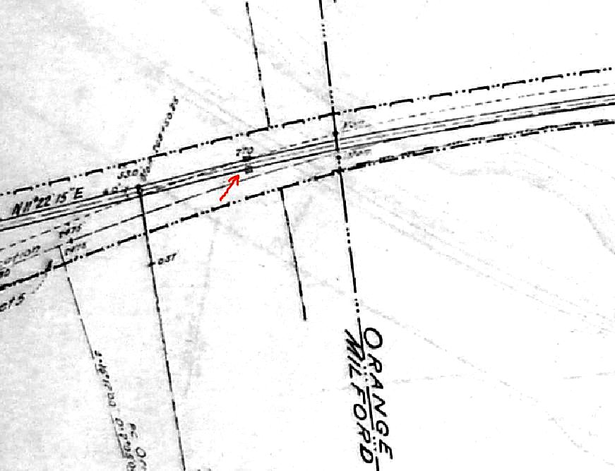
|
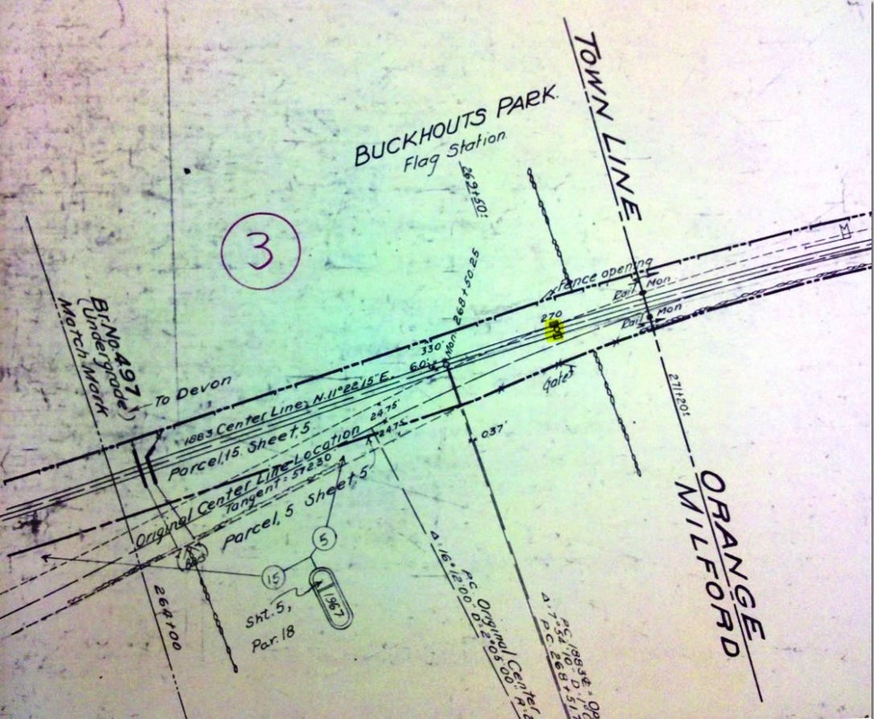
|
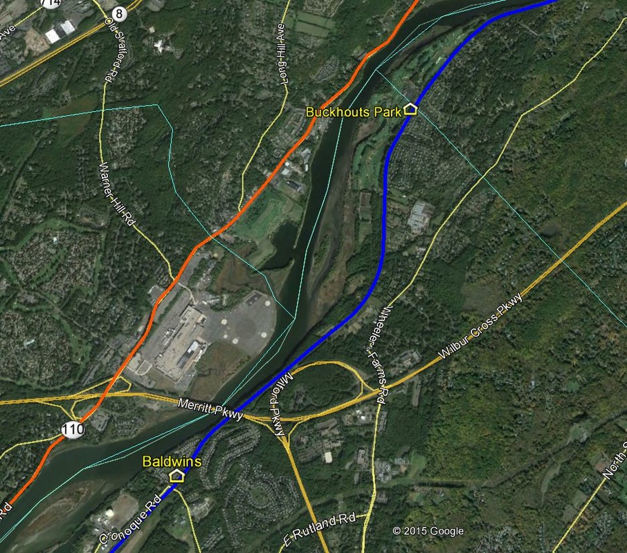
|
BUCKHOUTS PARK [NYNH&H, c1916?]
This station was for a residential enclave along the Housatonic River in the town of Milford, immediately below the Orange line. It was 2.9 miles above BALDWINS and 2.99 miles south of DERBY JUNCTION, according to timetables. It is not seen on the 1915 val map at [1] but we were able to locate it on a 1968 copy at [2], updated with changes subsequent to 1916. The map image shows the stop on the northern edge of Milford, just below the Orange border, though the 1918 Courant article cited below as well as the PUC decision said it was in Orange. No shed or platform is seen, only a gate and opening in the fence and planking across the track. Just when after 1915 this stop was established is unclear, but the PUC denied the NYNH&H request to discontinue it in 1918. The decision said there was "a substantial rural settlement" here without streetcar service, that the demands for accommodation were "fully as great as if not greater than at the time the station was established" and that continuing to stop trains on flag "should work no serious harm upon the company." The first reference we find to BUCKHOUT PARK, without the S, is in a state agricultural publication for 1914 listing a farm for sale near this station. It shows up on the 1919 ICC Valuation Order No. 3 list of stops but, since it is not on the 1928 NYNH&H Official List of Officers, Stations, Agents, it likely fell victim to the passenger service cutbacks of 1924. The Track 12 Google Earth map snippet at [3] shows the site today. [REFS: RAM1915: no; HC/12/06/1918/12; PUC Docket 2869 (11/26/1918)][rev070115]
BUCKLAND1 [HP&F, 1849; depot ????]
Station in the town of Manchester.
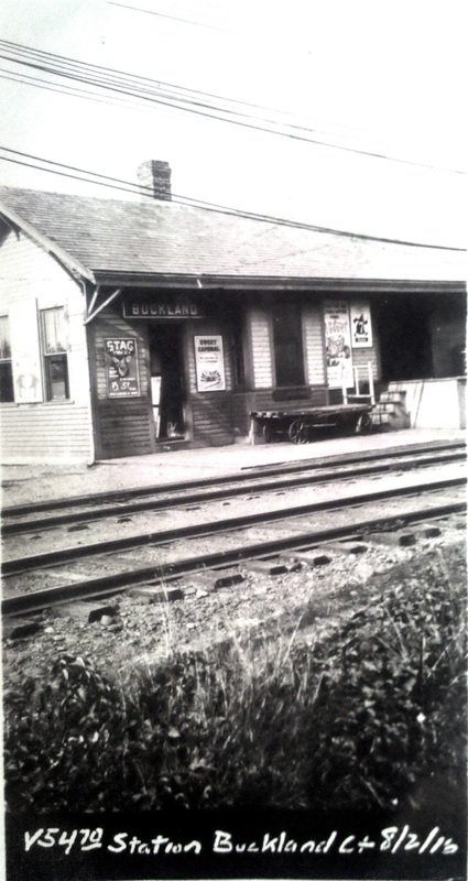
|

|
BUCKLAND2 [NYNH&H, c1900?]
BULLS BRIDGE [> SOUTH KENT]

Max Miller Collection
|
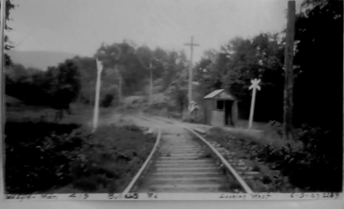
Max Miller Collection
|
BULLUS [Conn. Co., 1906]
Station in the town of Middletown. We do not know much about this stop, except that there was a nearby picnic grove of the same name in the early 1900s. Like EAST MERIDEN2, aka BEE STREET, this stop falls in the gray area of being a established on a steam railroad line after service was given over in 1907 to Connecticut Co. trolleys. It is probably for that reason that it does not appear as a station on the 1915 val map where the structure seen here is only described as a shed. Twenty years later, a 1927 Courant article says that buses would be taking over between Meriden and Middletown. Snow verifies that happening along today's Rte. 66 but, because of no suitable bus route to Westfield, he says trolley service was maintained on this line until 1932. [REFS: NHER/12/08/1898/05; HC/12/28/1906/13; HC/07/08/1907/16; HC/02/29/1908/10; HC/09/27/1927/ 08; S25,27][rev010214]
Station in the town of Middletown. We do not know much about this stop, except that there was a nearby picnic grove of the same name in the early 1900s. Like EAST MERIDEN2, aka BEE STREET, this stop falls in the gray area of being a established on a steam railroad line after service was given over in 1907 to Connecticut Co. trolleys. It is probably for that reason that it does not appear as a station on the 1915 val map where the structure seen here is only described as a shed. Twenty years later, a 1927 Courant article says that buses would be taking over between Meriden and Middletown. Snow verifies that happening along today's Rte. 66 but, because of no suitable bus route to Westfield, he says trolley service was maintained on this line until 1932. [REFS: NHER/12/08/1898/05; HC/12/28/1906/13; HC/07/08/1907/16; HC/02/29/1908/10; HC/09/27/1927/ 08; S25,27][rev010214]

|
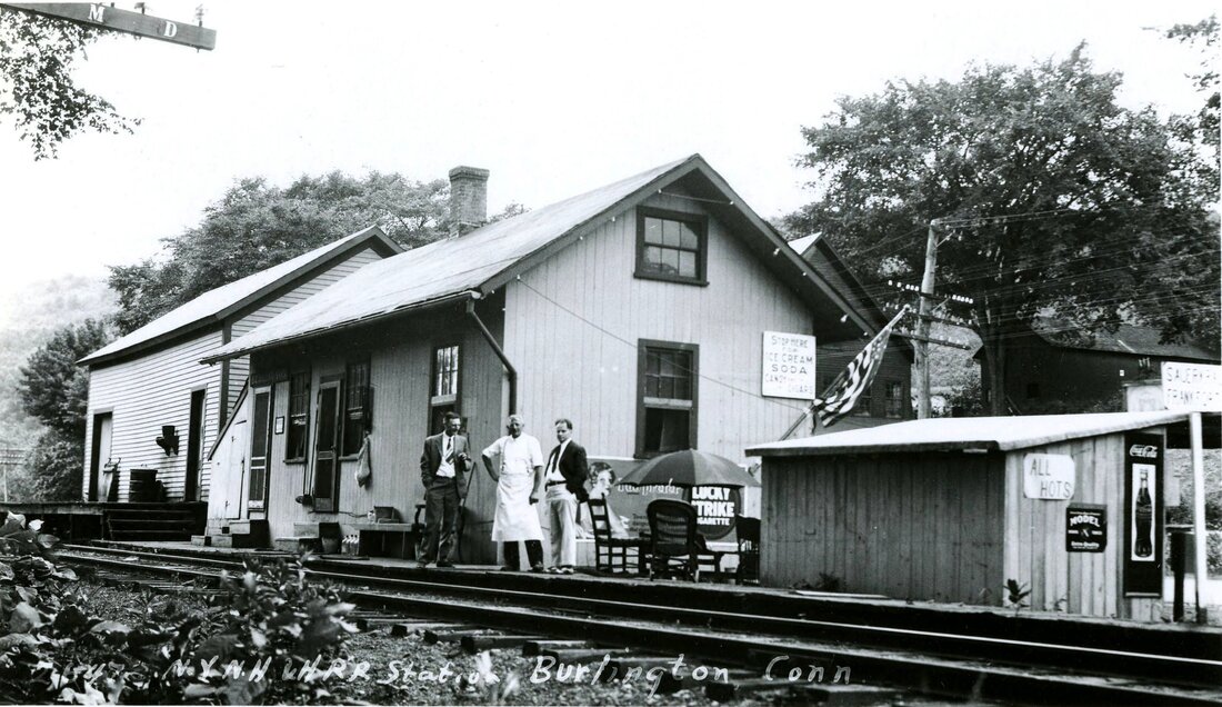
|
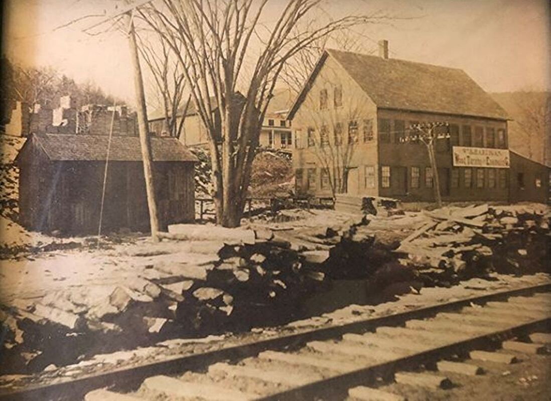
|
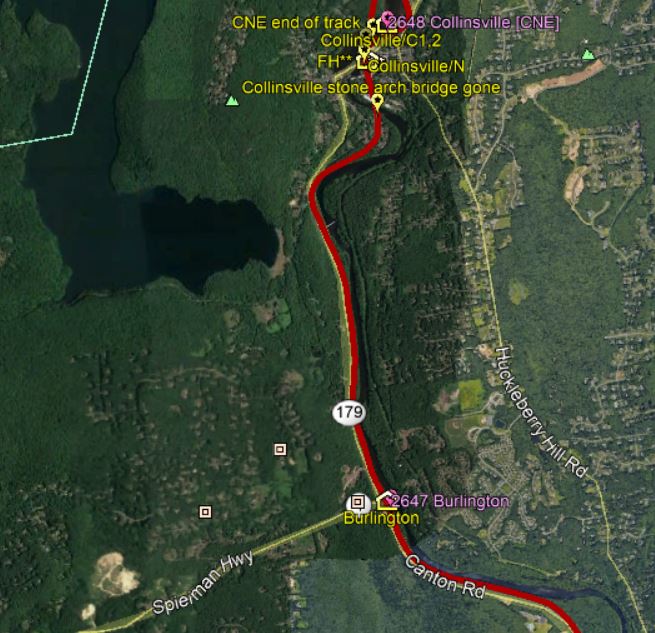
BURLINGTON [NH&N, 1870]
This was the Canal line station on the branch that was extended to PINE MEADOW in 1870 and NEW HARTFORD in 1876. The valuation shot at [1] is dated 9/27/1916. The image at [2] is Lewis H. Benton's #2467, taken in 1930, likely in June. It is a fabulous, well-composed shot showing a myriad of delicious detail. Irving Drake, fellow photographer and chauffeur, is at left, the 'restauranteur' may be the station agent; the gentleman on the right is unidentified. The 'M' and the 'D' on the crossarm of the telegraph pole signify dispatching and messaging circuits. Various lettered signs say 'Stop Here for Ice Cream, Soda, Candy, Cigars. Sauerkraut. Frankfurters. All Hots! Period ads for Coca Cola, Lucky Strike cigarettes round out the visuals but every item in view behind the depot is intriguing and telling; feel free to email us with more that you see. The freight building stands beyond the depot. A second-story window may indicate that the station agent lived upstairs in the depot. Peeking out above the station roofline is the W.R. Hartigan wood turning factory, a family-run business from 1869 that is still operating today. The photo at [3] shows the mill and wood logs delivered by rail. Canal line passenger service ended on 12/31/1925 but the running of trains on the CNE via Plainville and up the New Hartford Branch to Pine Meadow through 1927 extended life here as a commuter stop. Gas rail cars were used at the end. Fire likely struck the depot in 1936 or 1937. The newspaper said on 3/4/1937 "Old Depot Gone... The removal of the Burlington passenger depot marks the passing of one of the old landmarks. The old fire-gutted freight house still stands." Freight service lasted into the 1960s; track abandonment from Farmington to Collinsville was in 1968. [REFS: FVH/03/04/1937/03; D116+][rev081919]
This was the Canal line station on the branch that was extended to PINE MEADOW in 1870 and NEW HARTFORD in 1876. The valuation shot at [1] is dated 9/27/1916. The image at [2] is Lewis H. Benton's #2467, taken in 1930, likely in June. It is a fabulous, well-composed shot showing a myriad of delicious detail. Irving Drake, fellow photographer and chauffeur, is at left, the 'restauranteur' may be the station agent; the gentleman on the right is unidentified. The 'M' and the 'D' on the crossarm of the telegraph pole signify dispatching and messaging circuits. Various lettered signs say 'Stop Here for Ice Cream, Soda, Candy, Cigars. Sauerkraut. Frankfurters. All Hots! Period ads for Coca Cola, Lucky Strike cigarettes round out the visuals but every item in view behind the depot is intriguing and telling; feel free to email us with more that you see. The freight building stands beyond the depot. A second-story window may indicate that the station agent lived upstairs in the depot. Peeking out above the station roofline is the W.R. Hartigan wood turning factory, a family-run business from 1869 that is still operating today. The photo at [3] shows the mill and wood logs delivered by rail. Canal line passenger service ended on 12/31/1925 but the running of trains on the CNE via Plainville and up the New Hartford Branch to Pine Meadow through 1927 extended life here as a commuter stop. Gas rail cars were used at the end. Fire likely struck the depot in 1936 or 1937. The newspaper said on 3/4/1937 "Old Depot Gone... The removal of the Burlington passenger depot marks the passing of one of the old landmarks. The old fire-gutted freight house still stands." Freight service lasted into the 1960s; track abandonment from Farmington to Collinsville was in 1968. [REFS: FVH/03/04/1937/03; D116+][rev081919]

|
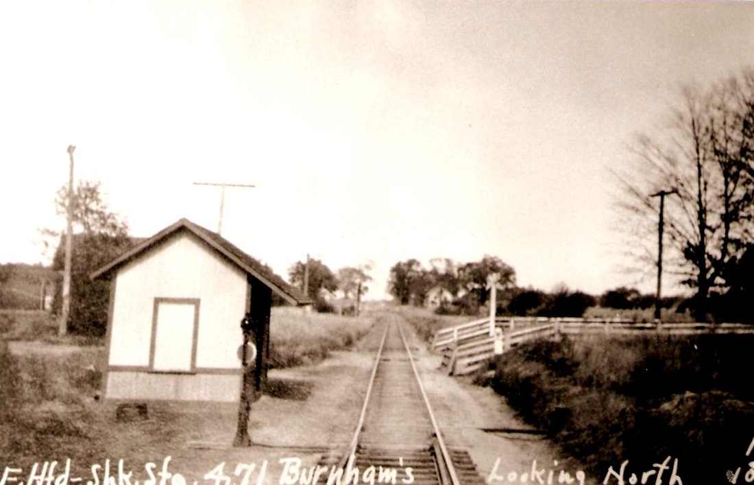
|
BURNHAMS [NY&NE, 1882?]
This stop was probably established at the northerly edge of the town of East Hartford around 1882 when it first shows up on the RRMs. The 1915 val map shows the tiny shelter in the photograph standing on the west side of the track. The view looks north toward Springfield on the Connecticut Central line that opened in 1876.
This stop was probably established at the northerly edge of the town of East Hartford around 1882 when it first shows up on the RRMs. The 1915 val map shows the tiny shelter in the photograph standing on the west side of the track. The view looks north toward Springfield on the Connecticut Central line that opened in 1876.
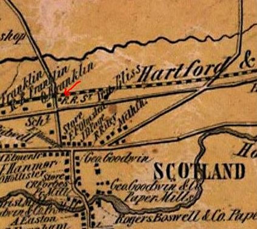
BURNSIDE1 [HP&F, 1849?; opens as SCOTLAND]
Station in the town of East Hartford. First called SCOTLAND, the sources reflect the name change to BURNSIDE between 1866 and 1873 and we wonder if had something to do with local ethnic appreciation of Gen. Ambrose Burnside's Civil War service and Scottish ancestry. While the first evidence we have of this stop is the 1855HC map at left, it may go back to the opening of the HP&F line from Hartford to Willimantic in 1849. In spite of the flourishing, church-going, law-abiding community here, this area seemed to have had its share of crime. The most shocking was the robbery and brutal assault that led to the death of elderly station agent Ira Bliss who was walking home with the railroad's receipts after closing up the depot on the night of 2/21/1873. John Dynes and Oscar Graves, ages 17 and 18 -- the Courant of 3/1/1873 recapped Dyne's confession -- pled guilty to second-degree murder and were imprisoned for life. Further criminal activity resulted in the burning of the station itself. The Hartford Times reported in 1876 as follows: "Monday, a few minutes after midnight [i.e. Tuesday, 8/29], the railroad station building at Burnside, a small wooden structure, was broken into and robbed and then set on fire. When first discovered, the fire was burning in the ticket office; the ticket-case was found outside, and rifled of its contents, and a ladder was resting against the west side of the building. It was impossible to save the building, and it was soon wholly destroyed. Not much booty was obtained by the burglars -- only $2 or $3, chiefly in nickels. It is high time some measures were taken to stop this frequent occurrence of crime in that neighborhood." We have no photograph yet of the "small wooden structure" that was BURNSIDE1 but Bradford Freeman was arrested for the arson on 9/23/1876. It seems a cruel and ironic coincidence that a depot named BURNSIDE was burned to the ground with a ladder up against its side. [REFS: GHD1858: Scotland; PTH107.1858.11; HDC/02/24/1873/02; MDC/02/24/1873/02; WDA/03/04/1873/03; MDC/09/24/1873/03; NA/10/01/1873/01; WDA/08/29/1876/03; BST/08/29/1873/03; CC/08/31/1876/04; CR/09/02/1876/02; HT/09/02/1876/02; HDC/09/25/1876/02][rev101321]
Station in the town of East Hartford. First called SCOTLAND, the sources reflect the name change to BURNSIDE between 1866 and 1873 and we wonder if had something to do with local ethnic appreciation of Gen. Ambrose Burnside's Civil War service and Scottish ancestry. While the first evidence we have of this stop is the 1855HC map at left, it may go back to the opening of the HP&F line from Hartford to Willimantic in 1849. In spite of the flourishing, church-going, law-abiding community here, this area seemed to have had its share of crime. The most shocking was the robbery and brutal assault that led to the death of elderly station agent Ira Bliss who was walking home with the railroad's receipts after closing up the depot on the night of 2/21/1873. John Dynes and Oscar Graves, ages 17 and 18 -- the Courant of 3/1/1873 recapped Dyne's confession -- pled guilty to second-degree murder and were imprisoned for life. Further criminal activity resulted in the burning of the station itself. The Hartford Times reported in 1876 as follows: "Monday, a few minutes after midnight [i.e. Tuesday, 8/29], the railroad station building at Burnside, a small wooden structure, was broken into and robbed and then set on fire. When first discovered, the fire was burning in the ticket office; the ticket-case was found outside, and rifled of its contents, and a ladder was resting against the west side of the building. It was impossible to save the building, and it was soon wholly destroyed. Not much booty was obtained by the burglars -- only $2 or $3, chiefly in nickels. It is high time some measures were taken to stop this frequent occurrence of crime in that neighborhood." We have no photograph yet of the "small wooden structure" that was BURNSIDE1 but Bradford Freeman was arrested for the arson on 9/23/1876. It seems a cruel and ironic coincidence that a depot named BURNSIDE was burned to the ground with a ladder up against its side. [REFS: GHD1858: Scotland; PTH107.1858.11; HDC/02/24/1873/02; MDC/02/24/1873/02; WDA/03/04/1873/03; MDC/09/24/1873/03; NA/10/01/1873/01; WDA/08/29/1876/03; BST/08/29/1873/03; CC/08/31/1876/04; CR/09/02/1876/02; HT/09/02/1876/02; HDC/09/25/1876/02][rev101321]
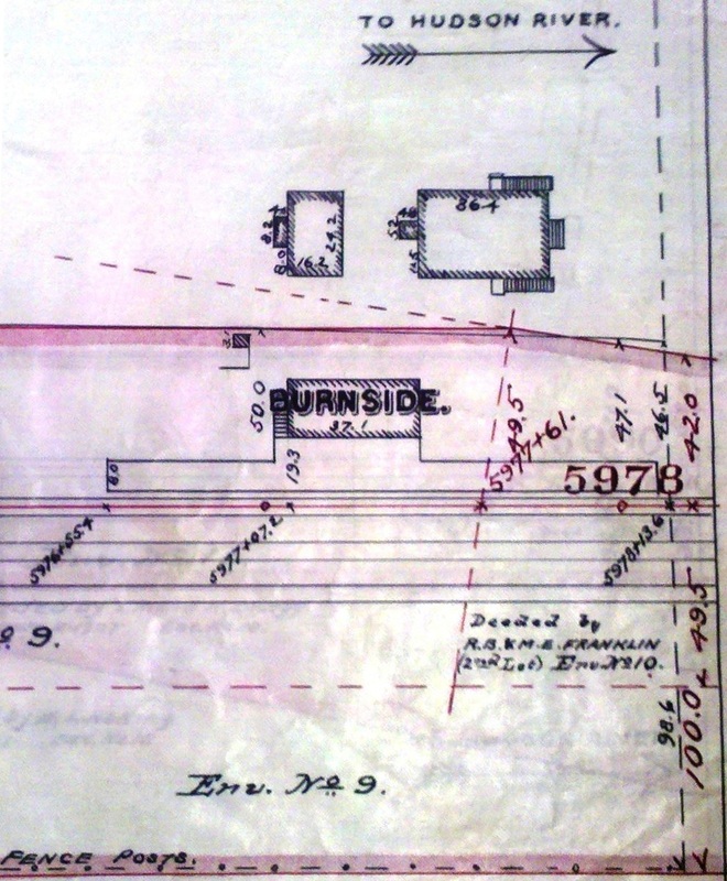
|
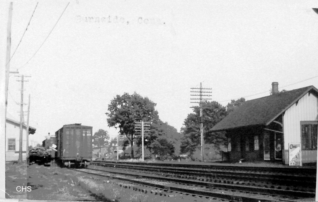
Connecticut Historical Society
|

|

|
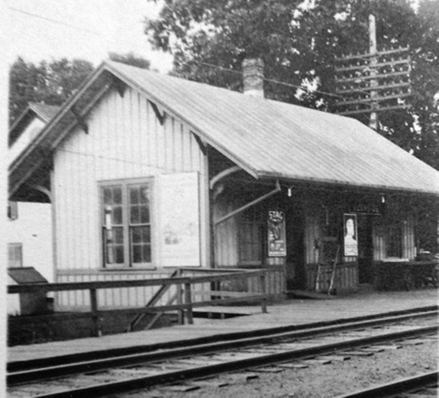
|

Cliff Black photo
|
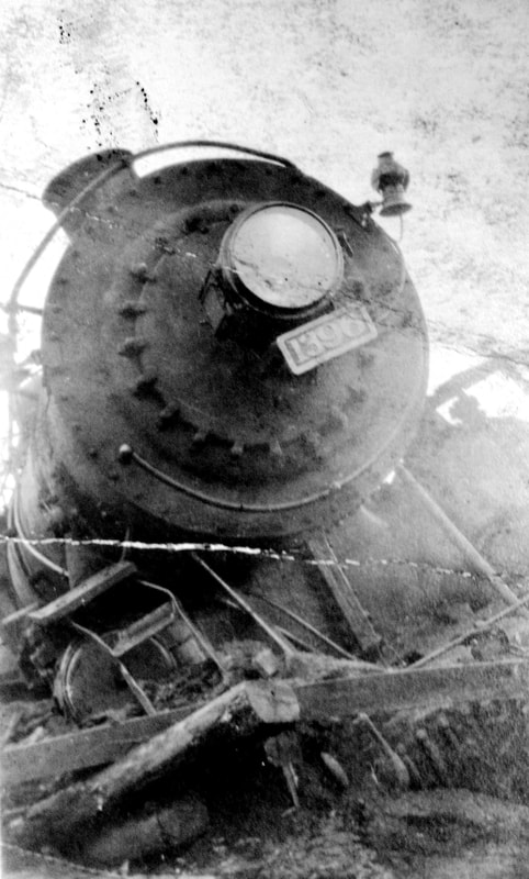 Ramsdell Collection
BURNSIDE2 [HP&F, 1876]
Coincident with the research on the first station, Harvard's Baker Library had the original receipt for the building of the replacement depot. Dated 10/9/1876, it says Erastus Phelps of Hartford was paid $900 "for furnishing material & building station at Burnside 37x16 as per agreement with L.B.B." the latter possibly one of the trustees for the HP&F, which was about to become part of the NY&NE. The railroad commissioners mentioned "considerable improvements" in their 1877 annual report, and apparently that included the new depot. Adding to the history of the criminal activity here, the Register reported in 1879 that Frank Thrall, "the embezzling New England railroad agent at Burnside station, and who absconded last Wednesday, saying he was going to South Carolina, has been arrested at Warehouse Point, while stripping tobacco." Nice try, Frank! The ca. 1890 real estate map at [1] shows the footprint of the second depot. It was built in the southeast quadrant of the School St. crossing, marked by the dashed line at right, where its predecessor stood. With the air brakes and automatic couplers on the box car, the shot at [2] dates to the 1920s or later. The 10/25/1927 PUC photo at [3] is a westward view with the freight house in the foreground on the north side of the tracks and BURNSIDE2 on the south side. The 6/30/1915 val map at [4] shows the station area layout at that time; the map view is southward and shows west on the right side. The red arrow points to the frame (i.e. wooden) freight house designated 'FF' on the map. The blue arrow points to the 'P' passenger station which, also wooden, is not indicated by 'FP' as is seen elsewhere. The heavy dashed lines on the right are the Connecticut Company trolley tracks to the East Hartford yard and a surface streetcar connection to the Insurance City, protected by SS 218 at the green arrow. Eastward from Burnside the NYNH&H's Rockville Interurban used the Highland Division tracks and the Rockville Branch, a connection which was made at Vernon depot and was protected by SS 219 there. Both towers opened on 12/3/1907 as a prelude to the interurban service, Roadmaster Condon was quoted as saying the system "... is the most exact in use anywhere. The element of danger is removed by it as completely as the human mind has yet conceived." The Melrose Branch was also electrified and lasted from the opening of the interurban service on 12/18/1907 reportedly until 1914. We are unaware of any collision between steam trains and the interurbans, and though the continuing fear stirred calls for discontinuance as early as 1917, it was kept running by popular demand until 1924. Conn. Co. turned over equipment to the NYNH&H on 10/12/1924. One notable acccident did occur here when the eastbound State of Maine on derailed at School St. on 6/6/1923 after just passing the point where the interurban tracks diverged. Towerman George Johnson considered himself "born lucky" to have escaped harm as SS 218 was apparently untouched. The val photo at [5] is dated 8/3/1916. We are not sure when the passenger station came down but it was probably prior to our 1938 SSRR on which it does not appear. SS 218 and 219 were closed in 1926, according to Bill Sample's NHRHTA list, a plausible date shortly after and due to the interuban's end of service. The image at [6] shows the freight house still standing in the early 1960s. The photo was donated by former Amtrak Chief of Corporate Communications, Cliff Black, who retired in 2010. We remember Cliff as spokesman in the 2000s. How time does fly! The image at [7] is the 1396, one of the two locomotives pulling the State of Maine in the 1923 wreck. The PUC later determined that sabotage was the cause of the wreck and rail historian Charlie Dunn reminds us that a shopmen's strike was in progress which would possibly explain the engine tampering that was discovered. [REFS: B759 (10/09/1876); CRC24.1877.20; NHER/11/17/1879/04; HC/11/28/1906/06; HC/12/03/1907/15; HC12/16/1907/10; HC/06/017/1923/01; HC/09/22/1923/01; NYT/09/23/1923/07; HC/10/12/1924/06][rev020813, 101321]
Coincident with the research on the first station, Harvard's Baker Library had the original receipt for the building of the replacement depot. Dated 10/9/1876, it says Erastus Phelps of Hartford was paid $900 "for furnishing material & building station at Burnside 37x16 as per agreement with L.B.B." the latter possibly one of the trustees for the HP&F, which was about to become part of the NY&NE. The railroad commissioners mentioned "considerable improvements" in their 1877 annual report, and apparently that included the new depot. Adding to the history of the criminal activity here, the Register reported in 1879 that Frank Thrall, "the embezzling New England railroad agent at Burnside station, and who absconded last Wednesday, saying he was going to South Carolina, has been arrested at Warehouse Point, while stripping tobacco." Nice try, Frank! The ca. 1890 real estate map at [1] shows the footprint of the second depot. It was built in the southeast quadrant of the School St. crossing, marked by the dashed line at right, where its predecessor stood. With the air brakes and automatic couplers on the box car, the shot at [2] dates to the 1920s or later. The 10/25/1927 PUC photo at [3] is a westward view with the freight house in the foreground on the north side of the tracks and BURNSIDE2 on the south side. The 6/30/1915 val map at [4] shows the station area layout at that time; the map view is southward and shows west on the right side. The red arrow points to the frame (i.e. wooden) freight house designated 'FF' on the map. The blue arrow points to the 'P' passenger station which, also wooden, is not indicated by 'FP' as is seen elsewhere. The heavy dashed lines on the right are the Connecticut Company trolley tracks to the East Hartford yard and a surface streetcar connection to the Insurance City, protected by SS 218 at the green arrow. Eastward from Burnside the NYNH&H's Rockville Interurban used the Highland Division tracks and the Rockville Branch, a connection which was made at Vernon depot and was protected by SS 219 there. Both towers opened on 12/3/1907 as a prelude to the interurban service, Roadmaster Condon was quoted as saying the system "... is the most exact in use anywhere. The element of danger is removed by it as completely as the human mind has yet conceived." The Melrose Branch was also electrified and lasted from the opening of the interurban service on 12/18/1907 reportedly until 1914. We are unaware of any collision between steam trains and the interurbans, and though the continuing fear stirred calls for discontinuance as early as 1917, it was kept running by popular demand until 1924. Conn. Co. turned over equipment to the NYNH&H on 10/12/1924. One notable acccident did occur here when the eastbound State of Maine on derailed at School St. on 6/6/1923 after just passing the point where the interurban tracks diverged. Towerman George Johnson considered himself "born lucky" to have escaped harm as SS 218 was apparently untouched. The val photo at [5] is dated 8/3/1916. We are not sure when the passenger station came down but it was probably prior to our 1938 SSRR on which it does not appear. SS 218 and 219 were closed in 1926, according to Bill Sample's NHRHTA list, a plausible date shortly after and due to the interuban's end of service. The image at [6] shows the freight house still standing in the early 1960s. The photo was donated by former Amtrak Chief of Corporate Communications, Cliff Black, who retired in 2010. We remember Cliff as spokesman in the 2000s. How time does fly! The image at [7] is the 1396, one of the two locomotives pulling the State of Maine in the 1923 wreck. The PUC later determined that sabotage was the cause of the wreck and rail historian Charlie Dunn reminds us that a shopmen's strike was in progress which would possibly explain the engine tampering that was discovered. [REFS: B759 (10/09/1876); CRC24.1877.20; NHER/11/17/1879/04; HC/11/28/1906/06; HC/12/03/1907/15; HC12/16/1907/10; HC/06/017/1923/01; HC/09/22/1923/01; NYT/09/23/1923/07; HC/10/12/1924/06][rev020813, 101321]

Dave Peters Collection
|
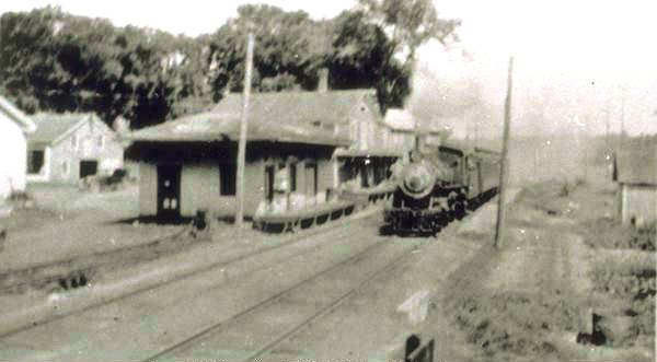
|

|
BURRVILLE [NRR, 1849; opened as ROSSITERVILLE]
Station in the town of Torrington. The location is seen on the 1854LC map. The val photo at left is dated 8/25/1916. This station, along with several others on the NRR from Waterbury to Winsted, lost passenger service in 1926. [REFS: HC/06/20/1926/A12; D97]
Station in the town of Torrington. The location is seen on the 1854LC map. The val photo at left is dated 8/25/1916. This station, along with several others on the NRR from Waterbury to Winsted, lost passenger service in 1926. [REFS: HC/06/20/1926/A12; D97]