Track 12: CT Passenger Stations, SP-SU
See TCS Home Page links for notes, abbreviations, and sources.
Use Track 11 map link to locate stations, rail and trolley lines, and POIs.
Use Track 11 map link to locate stations, rail and trolley lines, and POIs.
SPAFFORDSVILLE [> SOUTH WINDHAM]
SPAULDINGS SUMMIT [> NORFOLK SUMMIT]
SPRING BROOK [> SOUTH WETHERSFIELD]
SPAULDINGS SUMMIT [> NORFOLK SUMMIT]
SPRING BROOK [> SOUTH WETHERSFIELD]

Max Miller Collection
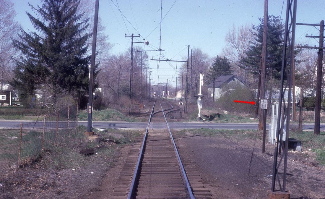
SPRING STREET [NYNH&H, 1906?]
A seminal article in the Shoreliner includes an ETT that shows this as a stop between WESTWAY, aka WEST STREET, and ROCKVILLE in the town of Vernon. Unless our eyes deceive us, we think we see a station in the center of this photograph. The line had been electrified by this time, as evidenced by the trolley wire. Residents in the vicinity had asked the Connecticut Company to establish a stop at Rau and Spring Sts. for their convenience. General Manager Punderford and Manager Bristol contacted Vernon town officials and made this a station on the Rockville Interurban which ran on mostly on steam tracks from 1907 until 1924. The 9/25/1923 PUC photo looks north. [REFS: HC/11/15/1907/11; SL13.2.32]
A seminal article in the Shoreliner includes an ETT that shows this as a stop between WESTWAY, aka WEST STREET, and ROCKVILLE in the town of Vernon. Unless our eyes deceive us, we think we see a station in the center of this photograph. The line had been electrified by this time, as evidenced by the trolley wire. Residents in the vicinity had asked the Connecticut Company to establish a stop at Rau and Spring Sts. for their convenience. General Manager Punderford and Manager Bristol contacted Vernon town officials and made this a station on the Rockville Interurban which ran on mostly on steam tracks from 1907 until 1924. The 9/25/1923 PUC photo looks north. [REFS: HC/11/15/1907/11; SL13.2.32]

|
|
SPRINGDALE1 [NC, 1868; depot, c1870]
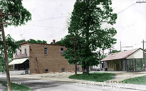
This Stamford stop was established in 1868 with the opening of the New Canaan RR but the history of the depots and arrangements here is unclear. We are inclined to think that the general store was the first place tickets were sold and continued to be where the storekeeper/station agent was located. When the post office was established in 1872, postmaster John M. Waterbury may well have worn all three hats. While Rosemary Burns says that two acres of land were donated in 1870 for a railroad station, we don't know precisely when a structure was built, but there is an 1875 newspaper article that refers to the "Springdale depot of the New Canaan railroad." The 1889 map at [1] shows a platform and perhaps a small waiting shed situated behind the general store. Fueling our assertion that station-agent activities took place in the store are the reports of when the store burned on 3/16/1905: "Fire in Springdale. The large country store, post office and railroad station combined, situated at Springdale, on the New Canaan division of the New York, New Haven & Hartford railroad, was gutted by fire to-day causing a loss of $11,000. Mr. Miller, the proprietor, says the loss is about half-covered by insurance. In the postoffice department all mail matter was destroyed with the exception of the registered mail which was in the safe. A large number of railroad tickets were also burned. It is thought to be the work of burglars who after robbing the store set the fire." The card at right shows the brick replacement structure after the store burned, the dating of which is confirmed by the trolley wire that was activated on the New Canaan line in June, 1898. By then, SPRINGDALE2 is already seen to the right. We have no photo of whatever structure preceded it. [REFS: CR/08/24/1872/03; CC/08/24/1872/04; CC/01/02/1875/04; NYHT/06/08/1887/04; AES/03/16/1905/01; DEN/03/16/1905 /05; PP/03/16/1905/02; Springdale Remembered, 1649-1949, p68][rev 031413]
This Stamford stop was established in 1868 with the opening of the New Canaan RR but the history of the depots and arrangements here is unclear. We are inclined to think that the general store was the first place tickets were sold and continued to be where the storekeeper/station agent was located. When the post office was established in 1872, postmaster John M. Waterbury may well have worn all three hats. While Rosemary Burns says that two acres of land were donated in 1870 for a railroad station, we don't know precisely when a structure was built, but there is an 1875 newspaper article that refers to the "Springdale depot of the New Canaan railroad." The 1889 map at [1] shows a platform and perhaps a small waiting shed situated behind the general store. Fueling our assertion that station-agent activities took place in the store are the reports of when the store burned on 3/16/1905: "Fire in Springdale. The large country store, post office and railroad station combined, situated at Springdale, on the New Canaan division of the New York, New Haven & Hartford railroad, was gutted by fire to-day causing a loss of $11,000. Mr. Miller, the proprietor, says the loss is about half-covered by insurance. In the postoffice department all mail matter was destroyed with the exception of the registered mail which was in the safe. A large number of railroad tickets were also burned. It is thought to be the work of burglars who after robbing the store set the fire." The card at right shows the brick replacement structure after the store burned, the dating of which is confirmed by the trolley wire that was activated on the New Canaan line in June, 1898. By then, SPRINGDALE2 is already seen to the right. We have no photo of whatever structure preceded it. [REFS: CR/08/24/1872/03; CC/08/24/1872/04; CC/01/02/1875/04; NYHT/06/08/1887/04; AES/03/16/1905/01; DEN/03/16/1905 /05; PP/03/16/1905/02; Springdale Remembered, 1649-1949, p68][rev 031413]
National Archives
|
Archives & Special Colls., UConn
|

|
Archives & Special Colls., UConn
|
Archives & Special Collections, UConn
|
|
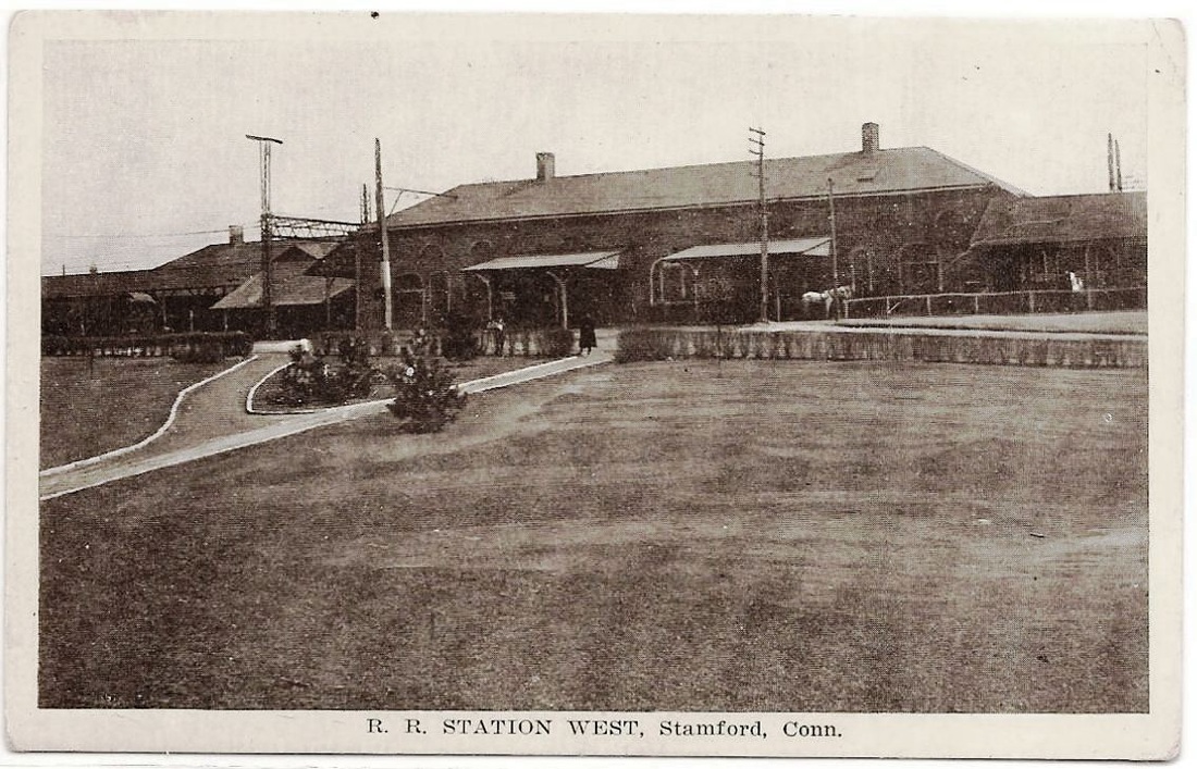
SPRINGDALE2 [NYNH&H, 1898]
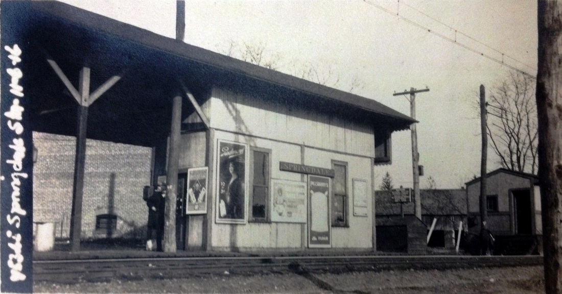
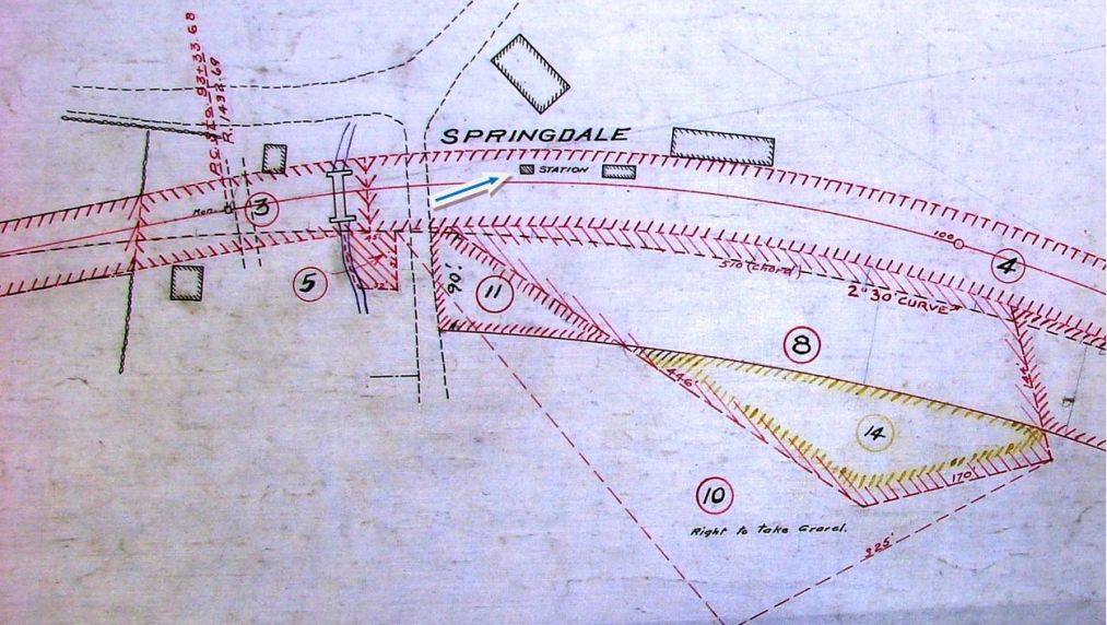
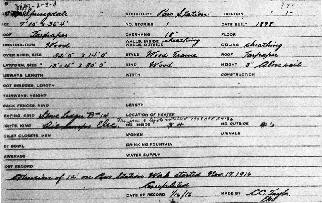
This station was built in 1898 and expanded just after the 11/6/1916 val photo at [1] was taken. The image at [2] is a 1900 real estate map with station at blue arrow, seemingly without platform or canopy. The 1916 val map at [3] shows the outline of the depot and covered platform at the red arrow. The images at [4] and [5] are of the 1916 real estate card, the back showing the floor plan and dimensions. The photo at [6] is a ca. 1940s view. The 1916 enlargement has added an extra window and also a ramp to the freight house that stood just to the north of the passenger station. We do not know when this depot came down but it was likely in 1974 with the building of the high-level platforms on the New Canaan branch and the main line. [REFS: NHER/08/23/1895/01; HC/05/23/1974/95D][rev031413]
This station was built in 1898 and expanded just after the 11/6/1916 val photo at [1] was taken. The image at [2] is a 1900 real estate map with station at blue arrow, seemingly without platform or canopy. The 1916 val map at [3] shows the outline of the depot and covered platform at the red arrow. The images at [4] and [5] are of the 1916 real estate card, the back showing the floor plan and dimensions. The photo at [6] is a ca. 1940s view. The 1916 enlargement has added an extra window and also a ramp to the freight house that stood just to the north of the passenger station. We do not know when this depot came down but it was likely in 1974 with the building of the high-level platforms on the New Canaan branch and the main line. [REFS: NHER/08/23/1895/01; HC/05/23/1974/95D][rev031413]
iridetheharlemline.com
SPRINGDALE3 [MN, 1974]
This high-level platform replaced the earlier wooden station. This structure sits below Largo Drive and is just south of the location of the earlier depots and also on the east side of the tracks. [REFS: HC/05/23/1974/95D][rev031413]
This high-level platform replaced the earlier wooden station. This structure sits below Largo Drive and is just south of the location of the earlier depots and also on the east side of the tracks. [REFS: HC/05/23/1974/95D][rev031413]
National Archives
|

|
|

|
|
SPRINGDALE CEMETERY1 [NYNH&H, 1898]
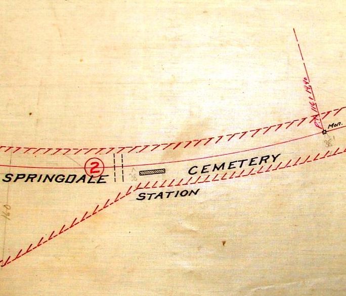
This intriguing New Canaan line stop was just north of the Stamford line in the town of Darien, the adjacent area in both towns called Springdale. This point was a mere half mile north of the SPRINGDALE stop and established mid-1898 undoubtedly for the benefit of traffic to the burial ground. The only stop we know of in the state named for, and later within, a cemetery. It is not on ETT #27 (11/28/1897) but it does appear on Supplement #6 to ETT #28 (12/4/1898). The val photo at [1] is dated 11/6/1916 and shows an unusually large shed, which was probably built to accomodate funeral parties and possibly the deceased as well. The 5/21/1899 ETT at [2] says "Trains will stop at Cemetery Platform, on signal, to leave or receive passengers." The 1900 ROW map at [3] is the first visual appearance we have seen. The 1915 val map at [4] shows the station structure on the east side of the track and Cemetery Siding is seen as well, the meeting point for up and down trains on this single-tracked line. A 1911 Meriden Morning Record article says that "the funeral of Thomas F. Collins will take place today in Stamford. The remains will be taken to that city on the 7:32 train this morning and services will be held at St. John's church at 9.30 o'clock. Interment will be at Springdale cemetery." Travel by train, though not stated outright, seems likely. Early unofficial use of this stop is said to have dated to the acquisition of the property, known alternately as Springdale Cemetery and today as St. John's Cemetery, at the same time as the NCRR opened on 7/4/1868 and laid its tracks along what was then the western edge of the burial ground. St. John's R.C. Church down in Stamford dates back to 1847, with the original property north of the tracks and west of Elm St. long gone. One 1902 reminiscence says that "in those days the railway was a greater convenience even than now, for the old church stood on Meadow Street in Stamford near the crossing and after service mourners and their friends could get on the cars and proceed to the burial ground conveniently and easily." The 1879 Hopkins map at [5] shows the proximity of the NCRR to church property, the circumscription of which lead them to purchase land for the new cemetery up north. Even from the new church built in 1875 at 279 Atlantic St., rail access to SPRINGDALE CEMETERY was still a short distance away. [REFS: HDC/07/03/1868/04; SA/02/20/1902/06][rev122514]
This intriguing New Canaan line stop was just north of the Stamford line in the town of Darien, the adjacent area in both towns called Springdale. This point was a mere half mile north of the SPRINGDALE stop and established mid-1898 undoubtedly for the benefit of traffic to the burial ground. The only stop we know of in the state named for, and later within, a cemetery. It is not on ETT #27 (11/28/1897) but it does appear on Supplement #6 to ETT #28 (12/4/1898). The val photo at [1] is dated 11/6/1916 and shows an unusually large shed, which was probably built to accomodate funeral parties and possibly the deceased as well. The 5/21/1899 ETT at [2] says "Trains will stop at Cemetery Platform, on signal, to leave or receive passengers." The 1900 ROW map at [3] is the first visual appearance we have seen. The 1915 val map at [4] shows the station structure on the east side of the track and Cemetery Siding is seen as well, the meeting point for up and down trains on this single-tracked line. A 1911 Meriden Morning Record article says that "the funeral of Thomas F. Collins will take place today in Stamford. The remains will be taken to that city on the 7:32 train this morning and services will be held at St. John's church at 9.30 o'clock. Interment will be at Springdale cemetery." Travel by train, though not stated outright, seems likely. Early unofficial use of this stop is said to have dated to the acquisition of the property, known alternately as Springdale Cemetery and today as St. John's Cemetery, at the same time as the NCRR opened on 7/4/1868 and laid its tracks along what was then the western edge of the burial ground. St. John's R.C. Church down in Stamford dates back to 1847, with the original property north of the tracks and west of Elm St. long gone. One 1902 reminiscence says that "in those days the railway was a greater convenience even than now, for the old church stood on Meadow Street in Stamford near the crossing and after service mourners and their friends could get on the cars and proceed to the burial ground conveniently and easily." The 1879 Hopkins map at [5] shows the proximity of the NCRR to church property, the circumscription of which lead them to purchase land for the new cemetery up north. Even from the new church built in 1875 at 279 Atlantic St., rail access to SPRINGDALE CEMETERY was still a short distance away. [REFS: HDC/07/03/1868/04; SA/02/20/1902/06][rev122514]
|
|

|
SPRINGDALE CEMETERY2 [NYNH&H, c1920?]
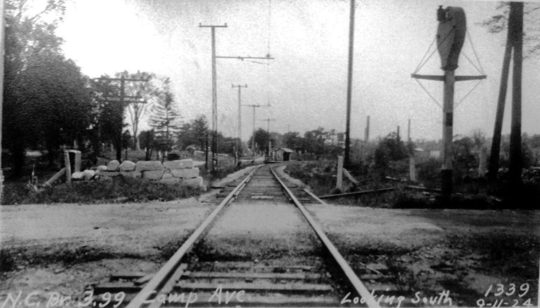
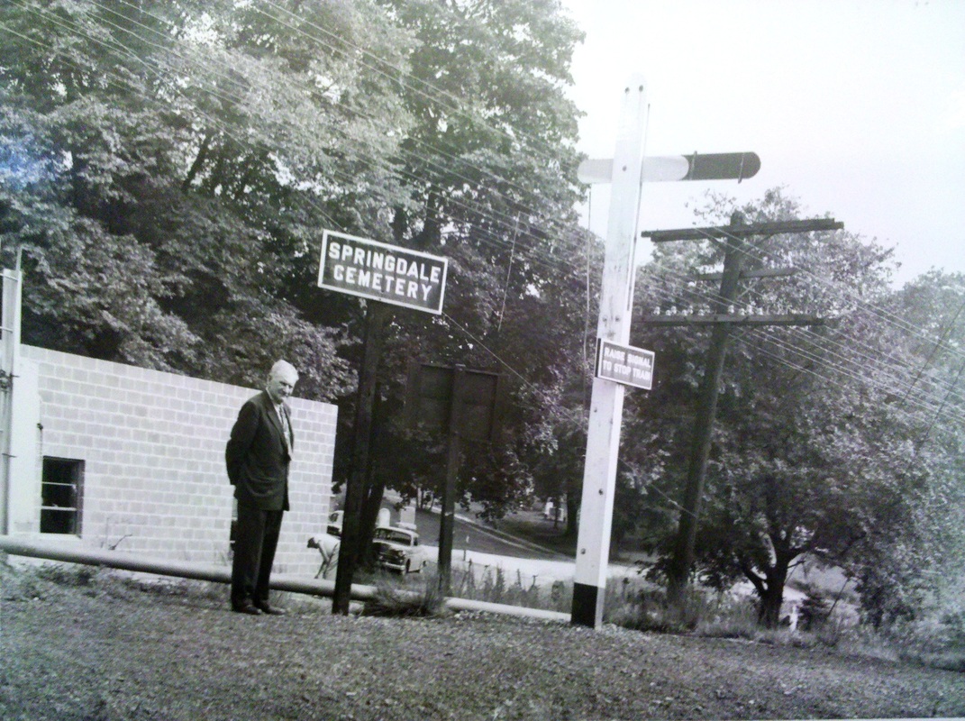
The 1924 PUC photo at [1] looks south toward the shelter from Camp Ave. The structure appears to be considerably smaller, perhaps cut down from the original, and we have designated this as the second depot here. Traffic may have fallen off after the opening of the Stamford Street Rwy to Camp Ave., approved in July, 1903 by the state railroad commissioners. The shot at [2] probably dates to the 1950s by the look of the automobile in the background. The gentleman seems to be waiting for the train and has raised the arm on the post, as instructed by the sign. This simple mechanism was one of many variants we have seen used to signal trains at flag stops like this. The location seems to be still within the cemetery, seen at our red arrow on the 1929 map at [3]. That map already shows the stop up at Camp Ave., though we think that may be confused with the trolley station. The growth of the cemetery to encompass land on both sides of the track by this time is apparent. [REFS: SA/07/16/1903/01; CRC51.1903.27; Stamford Street Rwy, p50][rev122414]
The 1924 PUC photo at [1] looks south toward the shelter from Camp Ave. The structure appears to be considerably smaller, perhaps cut down from the original, and we have designated this as the second depot here. Traffic may have fallen off after the opening of the Stamford Street Rwy to Camp Ave., approved in July, 1903 by the state railroad commissioners. The shot at [2] probably dates to the 1950s by the look of the automobile in the background. The gentleman seems to be waiting for the train and has raised the arm on the post, as instructed by the sign. This simple mechanism was one of many variants we have seen used to signal trains at flag stops like this. The location seems to be still within the cemetery, seen at our red arrow on the 1929 map at [3]. That map already shows the stop up at Camp Ave., though we think that may be confused with the trolley station. The growth of the cemetery to encompass land on both sides of the track by this time is apparent. [REFS: SA/07/16/1903/01; CRC51.1903.27; Stamford Street Rwy, p50][rev122414]
 Robert Gambling photo
SPRINGDALE CEMETERY3 [NYNH&H, c1960]
By the 1960s, according to Bob Gambling who rode the line at the time, no buildings remained in the cemetery and the stop was located at this Camp Ave. ballast patch. The view looks north; the sign at our red arrow seems to say "DO NOT ENTER" rather than SPRINGDALE CEMETERY, which our 2/2/1969 Penn Central timetable locates at 3.5 miles above Stamford and 4.0 miles below New Canaan on the 7.5-mi. branch. A collision, which Penn Central blamed on "apparent man failure on the part of the crew," took place on 8/20/1969 when a three-car northbound train did not take the siding as instructed and collided with a southbound dead-head move of nine cars. Four people died and 35 persons were injured in what was called "Connecticut's worst train accident in more than 40 years." Service at this stop would continue until it was eliminated on 7/17/1972 train schedule, riders being told to use the nearby SPRINGDALE station thereafter, just a half-mile to the south. [REFS: HC/08/21/1969/1A; NYT/08/22/1969/12; HC/08/23/1969/09; HC/09/06/1969/18; NYT/08/07/1971/08; HC/08/08/1971/26A; HC/07/02/1972/74D; HC/07/18/1972/21D][rev122514]
By the 1960s, according to Bob Gambling who rode the line at the time, no buildings remained in the cemetery and the stop was located at this Camp Ave. ballast patch. The view looks north; the sign at our red arrow seems to say "DO NOT ENTER" rather than SPRINGDALE CEMETERY, which our 2/2/1969 Penn Central timetable locates at 3.5 miles above Stamford and 4.0 miles below New Canaan on the 7.5-mi. branch. A collision, which Penn Central blamed on "apparent man failure on the part of the crew," took place on 8/20/1969 when a three-car northbound train did not take the siding as instructed and collided with a southbound dead-head move of nine cars. Four people died and 35 persons were injured in what was called "Connecticut's worst train accident in more than 40 years." Service at this stop would continue until it was eliminated on 7/17/1972 train schedule, riders being told to use the nearby SPRINGDALE station thereafter, just a half-mile to the south. [REFS: HC/08/21/1969/1A; NYT/08/22/1969/12; HC/08/23/1969/09; HC/09/06/1969/18; NYT/08/07/1971/08; HC/08/08/1971/26A; HC/07/02/1972/74D; HC/07/18/1972/21D][rev122514]
Stafford Historical Society
|
|
|
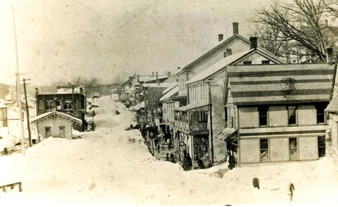
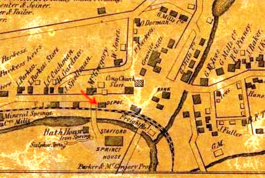
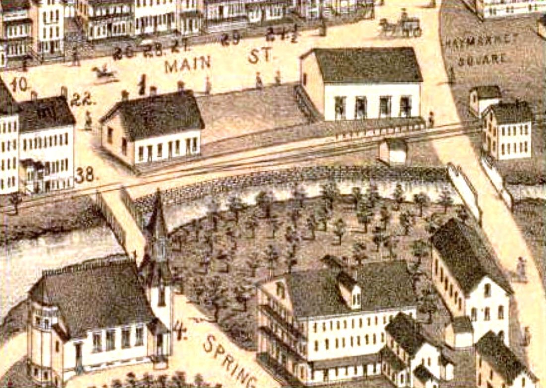
STAFFORD1 [NLW&P, 1850]
Called STAFFORD SPRINGS on some timetables, the first photographic image we have ever seen of this station is at [1], courtesy of our colleague and future TCS webmaster John Roy. The setting is the mounded snows of the Blizzard of 1888, which make the diminutive station on the left even smaller. The depot location is seen on the 1857TC map at [2]. The 1878 Bailey bird's-eye map at [3] shows the passenger station as the building with the locator number '1' over it. This is presumably the brick passenger station authorized by the directors on 9/3/1850, which, with a brick freight depot, cost a total of $3,100. [REFS: R94; W37][rev060818, 071420]
Called STAFFORD SPRINGS on some timetables, the first photographic image we have ever seen of this station is at [1], courtesy of our colleague and future TCS webmaster John Roy. The setting is the mounded snows of the Blizzard of 1888, which make the diminutive station on the left even smaller. The depot location is seen on the 1857TC map at [2]. The 1878 Bailey bird's-eye map at [3] shows the passenger station as the building with the locator number '1' over it. This is presumably the brick passenger station authorized by the directors on 9/3/1850, which, with a brick freight depot, cost a total of $3,100. [REFS: R94; W37][rev060818, 071420]

|

|
|

|

|
STAFFORD2 [CVT, 1893]
The second depot here is spoken of by the railroad commissioners in their 1893 annual report. Today it is owned by the town. The interesting shot at lower right showa a CVT train passing under the Stafford Springs Street Rwy which was certified on 5/18/1908 by the railroad commissioners as safe to operate. This property was one that the NYNH&H latched onto and purchased even before it opened, with Charles Rufus Harte, chief engineer for the Connecticut Co., certifying its value for legal purposes. The train, southbound, is approaching the STAFFORD2 station. [REFS: CRC41.1893.24; HC/08/01/1903/05; HC/01/30/1906/05; HC/12/07/1907/16; CRC56.1908.57; RRC map 640 (02/1907); R94; SL13.2.34][rev041913]
The second depot here is spoken of by the railroad commissioners in their 1893 annual report. Today it is owned by the town. The interesting shot at lower right showa a CVT train passing under the Stafford Springs Street Rwy which was certified on 5/18/1908 by the railroad commissioners as safe to operate. This property was one that the NYNH&H latched onto and purchased even before it opened, with Charles Rufus Harte, chief engineer for the Connecticut Co., certifying its value for legal purposes. The train, southbound, is approaching the STAFFORD2 station. [REFS: CRC41.1893.24; HC/08/01/1903/05; HC/01/30/1906/05; HC/12/07/1907/16; CRC56.1908.57; RRC map 640 (02/1907); R94; SL13.2.34][rev041913]

|

|

Stamford Historical Society
|
STAMFORD1 [NY&NH, 1848]
The 1850 Bradbury & Guild woodcut at left [add072813] shows two cross-gabled buildings the year after the NY&NH opened and the one in the foreground is likely the station. The location, seen on the 1856FC map at middle, is west of the canal, today's Canal St. The image at right one of a set of murals now in the possession of the Stamford Historical Society. The murals once graced the walls of the Fidelity Trust Company main office at 129 Atlantic Street. The bank commissioned the late Stanley J. Rowland, a noted artist, to paint the six Stamford scenes that included this one of the first train station. What Rowland based the station image on is unclear and, though the cross-gable is not in view, the lines of the depot otherwise seem to be correspond to images we have of the early NY&NH depots. No actual photo of this station has yet turned up. The railroad's 1867 annual report says that new depots were being built here and in Norwalk "in place of the old wooden buildings that were considered quite too small and unfit for the business of those places, and which have been removed, one of them being appropriated for freight use." NORWALK1 as freight house is seen standing alongside its successor on the 1875 bird's-eye map for that town. STAMFORD1 may have been converted to use as a locomotive watering facility, seen to the right of STAMFORD2 in the next entry. [REFS: Bradbury & Guild's Rail-Road Charts, no. 2, p78; HDC/01/12/1867/08; NYNHAR 00.1867.11][rev072813]
The 1850 Bradbury & Guild woodcut at left [add072813] shows two cross-gabled buildings the year after the NY&NH opened and the one in the foreground is likely the station. The location, seen on the 1856FC map at middle, is west of the canal, today's Canal St. The image at right one of a set of murals now in the possession of the Stamford Historical Society. The murals once graced the walls of the Fidelity Trust Company main office at 129 Atlantic Street. The bank commissioned the late Stanley J. Rowland, a noted artist, to paint the six Stamford scenes that included this one of the first train station. What Rowland based the station image on is unclear and, though the cross-gable is not in view, the lines of the depot otherwise seem to be correspond to images we have of the early NY&NH depots. No actual photo of this station has yet turned up. The railroad's 1867 annual report says that new depots were being built here and in Norwalk "in place of the old wooden buildings that were considered quite too small and unfit for the business of those places, and which have been removed, one of them being appropriated for freight use." NORWALK1 as freight house is seen standing alongside its successor on the 1875 bird's-eye map for that town. STAMFORD1 may have been converted to use as a locomotive watering facility, seen to the right of STAMFORD2 in the next entry. [REFS: Bradbury & Guild's Rail-Road Charts, no. 2, p78; HDC/01/12/1867/08; NYNHAR 00.1867.11][rev072813]

|
|
Stamford Historical Society
|
STAMFORD2 [NY&NH, 1867]
While the newspapers reported on this station before and after its opening, no definitive celebratory article has yet been found. The railroad commissioners say that the expected completion date was 5/1/1867 but the NY&NH annual report, dated 5/16/1867, said that work was to be finished within the month. Further details describe it, as well as its contemporary cousin in Norwalk as "good and substantial buildings of brick, with slate and tin roofs." Similar in design, they were both handsome two-story structures with Mansard roof, approximately 210 feet by 24 feet. The photo at left may well be ca. 1870. Note the water tanks at each end of the depot, the one on the right possibly STAMFORD1 repurposed. The image at middle [add072913] is from the O.H. Bailey 1875 bird's-eye map [click here] and shows STAMFORD2 between the Consolidated's up and down tracks. Note the spur running down to the canal, which some sources say was to be used by the New Canaan RR for its own boat connections to New York. The NCRR, which opened in 1868 and was leased by the NYNH&H in 1883, also appears to have used STAMFORD2 since its passenger service originated and terminated there. A separate NCRR station in Stamford, however superfluous, was mentioned in an 1868 Courant article that said one was going up at Park and Elm Sts., a seemingly non-existent location that is found neither on the bird's-eye maps of 1875 and 1883 nor at any other likely location along the track. In February, 1897, the Register said that STAMFORD2 was going to be demolished shortly now that successor STAMFORD3 had opened. The shot at right [add072913] shows a trolley on State St. passing by the station some time after the 1894 electrification of the old horse-car line. [REFS: HDC/04/11/1866/02; CR/09/29/1866/01; NYNHAR1867.12; CRC14.1867.13; CC/01/19/1867/01; CH/05/18/1867/02; HDC/01/20/1868/02; HT/04/18/1868/03; CC/05/27/1871/07; NHER/02/08/1897/03; R94: razed 1893 is incorrect][rev081713]
While the newspapers reported on this station before and after its opening, no definitive celebratory article has yet been found. The railroad commissioners say that the expected completion date was 5/1/1867 but the NY&NH annual report, dated 5/16/1867, said that work was to be finished within the month. Further details describe it, as well as its contemporary cousin in Norwalk as "good and substantial buildings of brick, with slate and tin roofs." Similar in design, they were both handsome two-story structures with Mansard roof, approximately 210 feet by 24 feet. The photo at left may well be ca. 1870. Note the water tanks at each end of the depot, the one on the right possibly STAMFORD1 repurposed. The image at middle [add072913] is from the O.H. Bailey 1875 bird's-eye map [click here] and shows STAMFORD2 between the Consolidated's up and down tracks. Note the spur running down to the canal, which some sources say was to be used by the New Canaan RR for its own boat connections to New York. The NCRR, which opened in 1868 and was leased by the NYNH&H in 1883, also appears to have used STAMFORD2 since its passenger service originated and terminated there. A separate NCRR station in Stamford, however superfluous, was mentioned in an 1868 Courant article that said one was going up at Park and Elm Sts., a seemingly non-existent location that is found neither on the bird's-eye maps of 1875 and 1883 nor at any other likely location along the track. In February, 1897, the Register said that STAMFORD2 was going to be demolished shortly now that successor STAMFORD3 had opened. The shot at right [add072913] shows a trolley on State St. passing by the station some time after the 1894 electrification of the old horse-car line. [REFS: HDC/04/11/1866/02; CR/09/29/1866/01; NYNHAR1867.12; CRC14.1867.13; CC/01/19/1867/01; CH/05/18/1867/02; HDC/01/20/1868/02; HT/04/18/1868/03; CC/05/27/1871/07; NHER/02/08/1897/03; R94: razed 1893 is incorrect][rev081713]

|
National Archives
|

National Archives
|
|

|
|
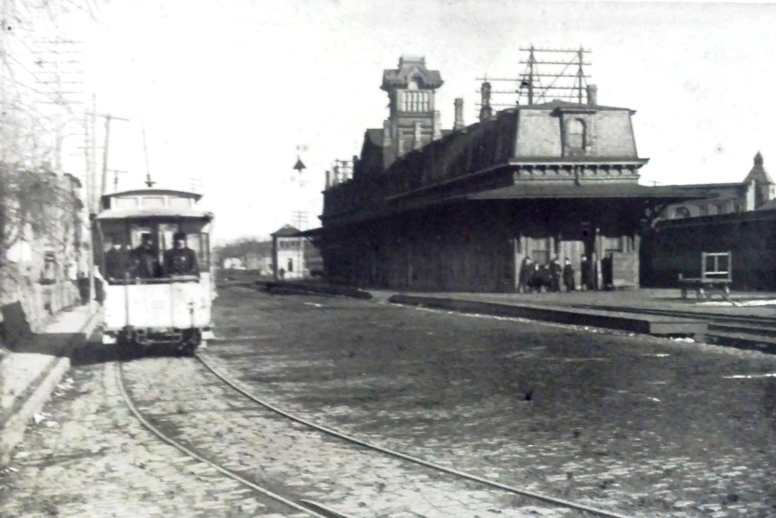
STAMFORD3 [NYNH&H, 1897, WB]
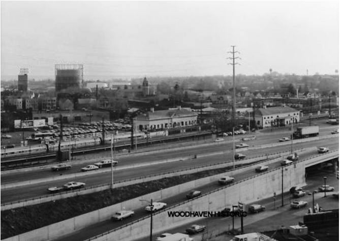
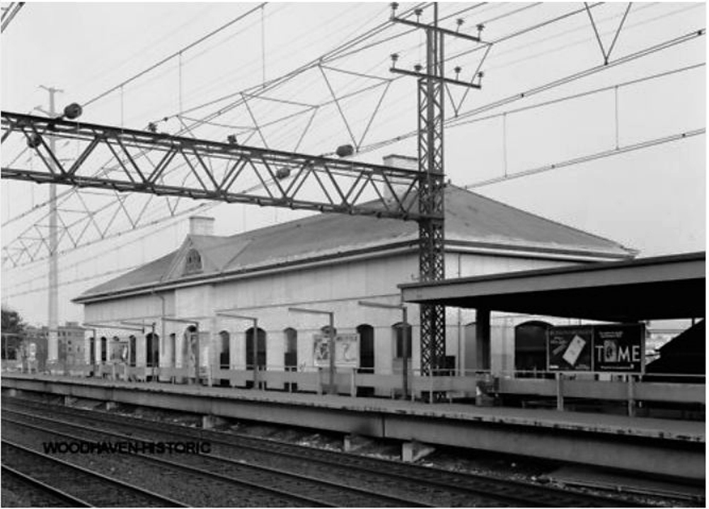
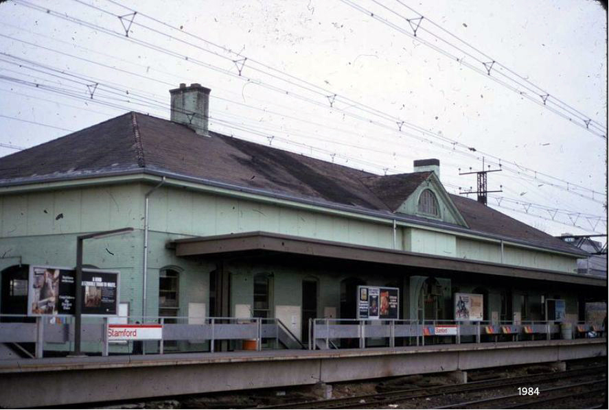
This station stood on the westbound side of the main line and was finished probably just before February, 1897, according the Register. This coincided with the completion of the elevation and four-tracking of the New York Division, except for Bridgeport; ballasting was expected to be done by June. The station was described as a handsome structure built of yellow pressed bricks with a tunnel under the tracks for passengers to access the twin facility on the other side. The work here reportedly cost the NYNH&H $550,000 for the improvements that doubled track capacity and eliminated grade crossings. The card at upper left looks west with this station on the right hand side. The val photos at upper middle and right are dated 1917. This station stood until October, 1983, apparently with STAMFORD4 on the eastbound side used thereafter. Stamford House Wrecking was allowed to pry off and sell the iron cornices and the 12 wood roof trusses were salvaged for the Branford Trolley Museum in East Haven were they were to be installed in a new storage barn. The buff-colored pressed brick, repainted in later days to a pastel green, were deemed of no value and were to be scrapped. A "pick and bucket" operation would be used to take the building down. "We can't explode it or hit it with a wrecking ball because we would have bricks flying onto the tracks and dirt falling into commuters' coffee cups," explained Paul Disario, the project manager. [REFS: NHER/08/05/1895/01; NHER/02/06/1897/03; NHER/02/08/1897/03; NYT/06/05/1983/CN15; NYT/10/02/1983/CN3; R94: opened 1893?; RHA 5/24/55][rev072913]
This station stood on the westbound side of the main line and was finished probably just before February, 1897, according the Register. This coincided with the completion of the elevation and four-tracking of the New York Division, except for Bridgeport; ballasting was expected to be done by June. The station was described as a handsome structure built of yellow pressed bricks with a tunnel under the tracks for passengers to access the twin facility on the other side. The work here reportedly cost the NYNH&H $550,000 for the improvements that doubled track capacity and eliminated grade crossings. The card at upper left looks west with this station on the right hand side. The val photos at upper middle and right are dated 1917. This station stood until October, 1983, apparently with STAMFORD4 on the eastbound side used thereafter. Stamford House Wrecking was allowed to pry off and sell the iron cornices and the 12 wood roof trusses were salvaged for the Branford Trolley Museum in East Haven were they were to be installed in a new storage barn. The buff-colored pressed brick, repainted in later days to a pastel green, were deemed of no value and were to be scrapped. A "pick and bucket" operation would be used to take the building down. "We can't explode it or hit it with a wrecking ball because we would have bricks flying onto the tracks and dirt falling into commuters' coffee cups," explained Paul Disario, the project manager. [REFS: NHER/08/05/1895/01; NHER/02/06/1897/03; NHER/02/08/1897/03; NYT/06/05/1983/CN15; NYT/10/02/1983/CN3; R94: opened 1893?; RHA 5/24/55][rev072913]
National Archives
|
National Archives
|
|
|
|

|
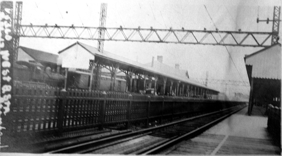
STAMFORD4 [NYNH&H, 1897, EB]
This was the twin station that stood on the eastbound side of the track and presumably was opened early in 1897 like its counterpart across the tracks. The val photos at upper left and middle are dated 1917. The 1983 shot at upper right has this station almost dead center, with the Connecticut Turnpike in the foreground. The view at lower right shows STAMFORD5 going up in the rear of STAMFORD4, which would be razed late in November, 1987 after the new transportation center opened. [REFS: NYT/06/05/1983/CN15; NYT/11/23/1987/B1; R94][rev072913]
This was the twin station that stood on the eastbound side of the track and presumably was opened early in 1897 like its counterpart across the tracks. The val photos at upper left and middle are dated 1917. The 1983 shot at upper right has this station almost dead center, with the Connecticut Turnpike in the foreground. The view at lower right shows STAMFORD5 going up in the rear of STAMFORD4, which would be razed late in November, 1987 after the new transportation center opened. [REFS: NYT/06/05/1983/CN15; NYT/11/23/1987/B1; R94][rev072913]

|
|
STAMFORD5 [MN/ATK, 1987]
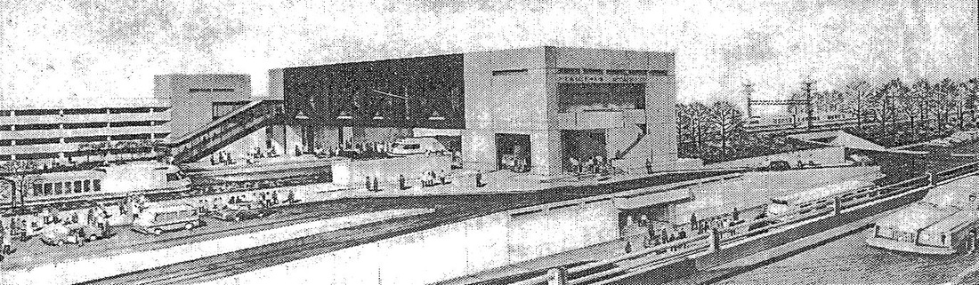
Built of brick and aluminum, this station opened on 11/23/1987 amidst ridicule as a "monument to miscalculation," three years after its first projected opening date and still unfinished. The major reason for the delay was design flaws that necessitated the almost complete demolition and reconstruction of the facility. The 1983 newspaper photo at right shows the projected appearance, later to be recast because of design flaws in the original plans. [REFS: NYT/01/16/1983/54l; NYT/11/23/1987/B1; R94, WP][rev072913]
Built of brick and aluminum, this station opened on 11/23/1987 amidst ridicule as a "monument to miscalculation," three years after its first projected opening date and still unfinished. The major reason for the delay was design flaws that necessitated the almost complete demolition and reconstruction of the facility. The 1983 newspaper photo at right shows the projected appearance, later to be recast because of design flaws in the original plans. [REFS: NYT/01/16/1983/54l; NYT/11/23/1987/B1; R94, WP][rev072913]
Joseph Cerreto Collection
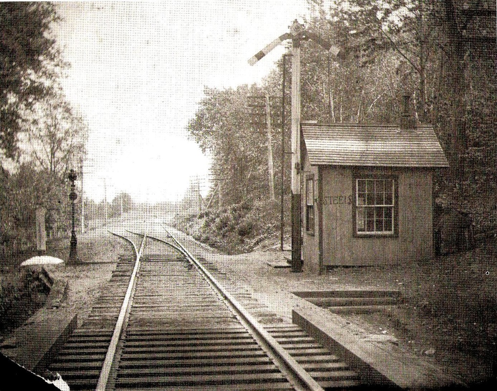
STEELES [NY&NE?, c1885?]
Also spelled STEELS. Switchmen, stationed here and also at CLUB HOUSE to the east, controlled access to and from the section of rail that narrowed from double to single track between these points. It has been noted that this photo probably dates to before 1900 since no tie plates are being used. We do not know if these were 'stations' used by the public. It is more likely that these locations were only on employee timetables for use in controlling train movements. [rev122017]
Also spelled STEELS. Switchmen, stationed here and also at CLUB HOUSE to the east, controlled access to and from the section of rail that narrowed from double to single track between these points. It has been noted that this photo probably dates to before 1900 since no tie plates are being used. We do not know if these were 'stations' used by the public. It is more likely that these locations were only on employee timetables for use in controlling train movements. [rev122017]

|
|
|
Monroe Historical Society
|
Monroe Historical Society
|

|
STEPNEY1 [HRR, 1840]
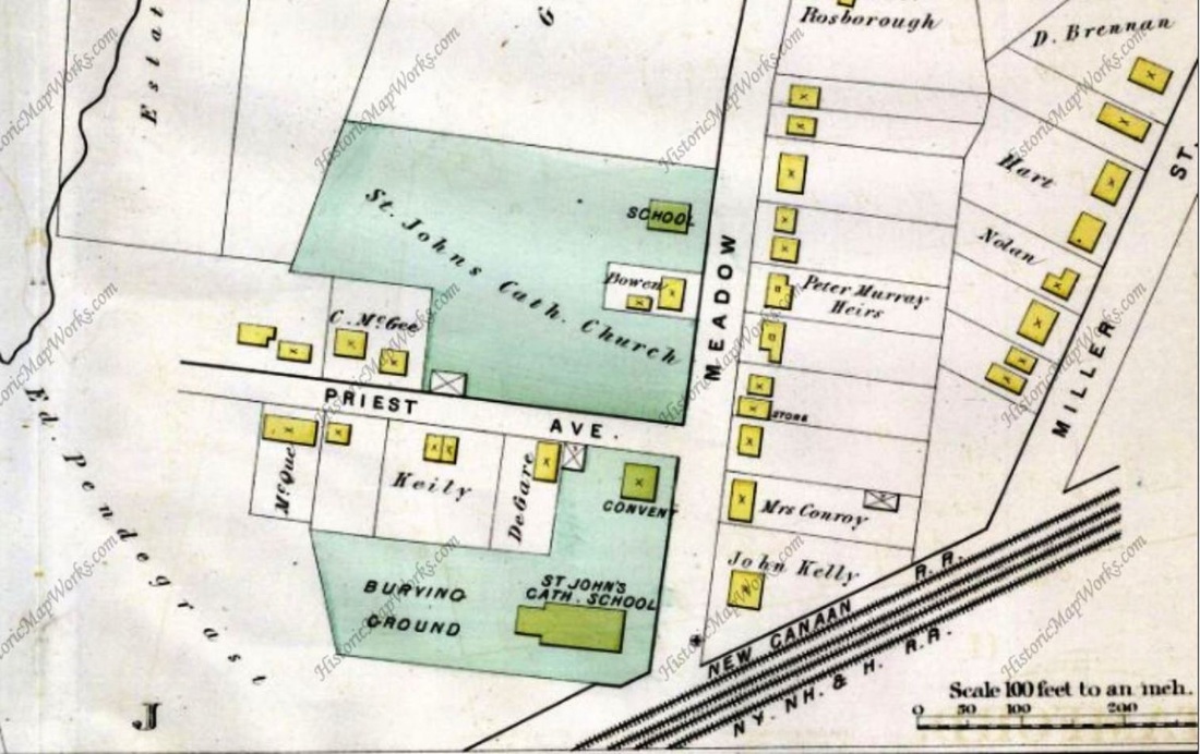
The pre-opening, newspaper timetable of 2/3/1840 at [1] shows this station in the town of Monroe as LEAVENWORTH'S MILLS. Railroad records show that the HRR purchased land from Andrew Leavenworth, namesake property owner and entrepreneur, on 6/12/1839. By the 1850s, the stop is seen under its new name on the Fourth of July broadside at [3]. The 1856FC map at [2] shows the 'Depot' on the east side of the track [right arrow] but a historical description of Monroe in the 3/25/1892 Newtown Bee upholds our long-held assertion that the passenger station was in the building that housed a store and the post office west of the track. "Written several years ago by a boy 15 years old," it says that "It [Monroe] boasts of one railroad, the Housatonic, with a station at Lower Stepney. The depot building also contains a grocery store and post office and, like any country store, is well filled with story tellers and tobacco smoke, especially on rainy Summer days and Winter evenings..." We note that the actual date of the reminiscence must be before 1888 when the NH&D added a second railroad to the town and this fact also adds authenticity to the boy's narrative. The Stepney Depot post office, was established in 1849 and Postmaster Alan Platt, appointed in 1851, is in fact shown to be living in the store/post office on the 1856FC map [left arrow]. The building, shown in the recent shot at [3], pre-dates the railroad and had a succession of owners who wore the hats of storekeeper, station agent, telegraph operator and postmaster, as the Bee said in 1877; long-time agent Stephen French even after his retirement from railroad service still advertised his store business as 'at the Depot.' The structure still stands today at the sharp bend in the road at 38 Maple Dr. and that bay window hanging over the street has always intrigued us. Railroad stations often had such bay windows at street level to give agents a good three-way view of the tracks. The fact that this one is on the second floor may make it purely an architectural ornament, but nevertheless a great train-watching spot in the day! Some sources claim that the store was also a hotel, perhaps meaning that rooms upstairs were rented out, at some point by the hour if you believe the more colorful claims. It is worth noting that other early HRR stations were in hotels at CANAAN, KENT, and MERWINSVILLE. Many thanks once again to Kevin Daly, Monroe's own busy historical bee, for bringing the 1892 article to our attention! [REFS: NBE/07/12/1877/03; NBE/03/25/1892/03; NBE/11/13/1908/01: French's will] [rev123117]
The pre-opening, newspaper timetable of 2/3/1840 at [1] shows this station in the town of Monroe as LEAVENWORTH'S MILLS. Railroad records show that the HRR purchased land from Andrew Leavenworth, namesake property owner and entrepreneur, on 6/12/1839. By the 1850s, the stop is seen under its new name on the Fourth of July broadside at [3]. The 1856FC map at [2] shows the 'Depot' on the east side of the track [right arrow] but a historical description of Monroe in the 3/25/1892 Newtown Bee upholds our long-held assertion that the passenger station was in the building that housed a store and the post office west of the track. "Written several years ago by a boy 15 years old," it says that "It [Monroe] boasts of one railroad, the Housatonic, with a station at Lower Stepney. The depot building also contains a grocery store and post office and, like any country store, is well filled with story tellers and tobacco smoke, especially on rainy Summer days and Winter evenings..." We note that the actual date of the reminiscence must be before 1888 when the NH&D added a second railroad to the town and this fact also adds authenticity to the boy's narrative. The Stepney Depot post office, was established in 1849 and Postmaster Alan Platt, appointed in 1851, is in fact shown to be living in the store/post office on the 1856FC map [left arrow]. The building, shown in the recent shot at [3], pre-dates the railroad and had a succession of owners who wore the hats of storekeeper, station agent, telegraph operator and postmaster, as the Bee said in 1877; long-time agent Stephen French even after his retirement from railroad service still advertised his store business as 'at the Depot.' The structure still stands today at the sharp bend in the road at 38 Maple Dr. and that bay window hanging over the street has always intrigued us. Railroad stations often had such bay windows at street level to give agents a good three-way view of the tracks. The fact that this one is on the second floor may make it purely an architectural ornament, but nevertheless a great train-watching spot in the day! Some sources claim that the store was also a hotel, perhaps meaning that rooms upstairs were rented out, at some point by the hour if you believe the more colorful claims. It is worth noting that other early HRR stations were in hotels at CANAAN, KENT, and MERWINSVILLE. Many thanks once again to Kevin Daly, Monroe's own busy historical bee, for bringing the 1892 article to our attention! [REFS: NBE/07/12/1877/03; NBE/03/25/1892/03; NBE/11/13/1908/01: French's will] [rev123117]

|
|
|
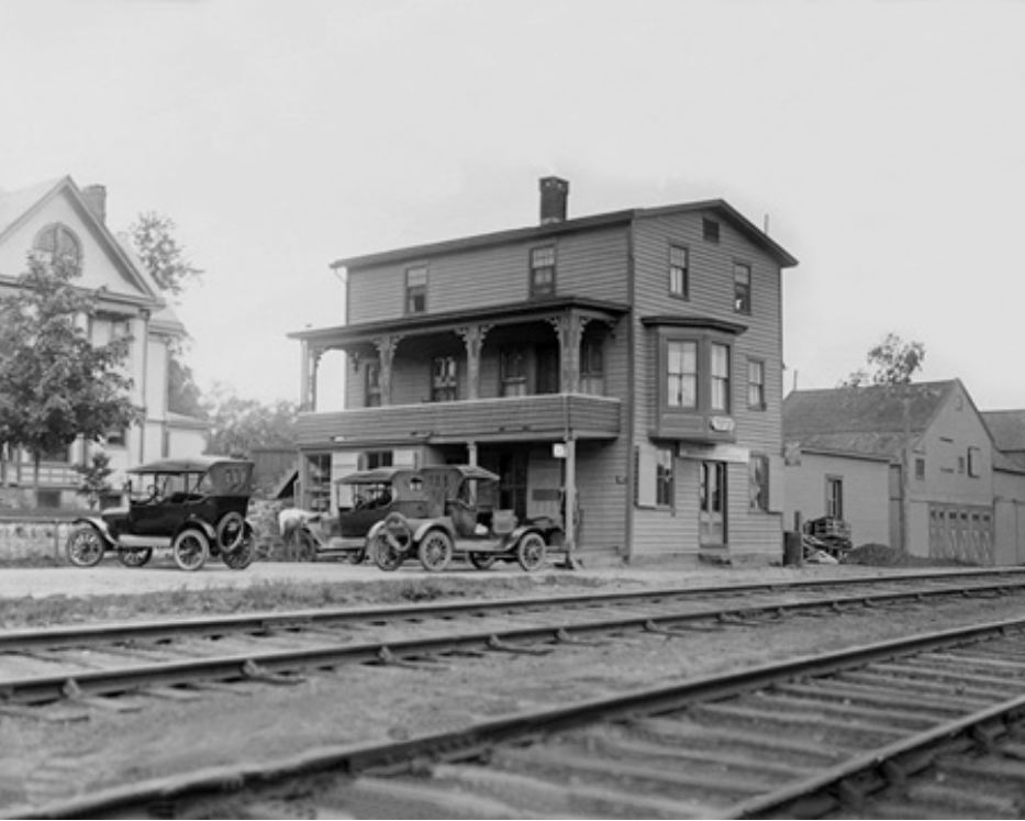
STEPNEY2 [NYNH&H, c1895?]
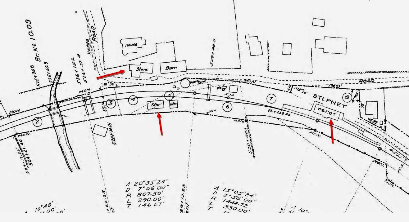
In taking a closer look at this depot and going by John Roy's statement that the 1905 station was erected to replace "a short-lived but smaller structure built around the turn of the century..." also constructed by the NYNH&H, this has to be that earlier depot, opposite the store that served as STEPNEY1. Its location is the same as the old freight depot seen above on the 1856FC map. The NYNH&H leased the HRR in 1892 so STEPNEY2 would have to have been put up in the years following, perhaps 1895. Ten years later, likely owing to the lack of space room at the tight and commercially busy bend on Maple Dr., STEPNEY3 was built a little farther north. As that one was opening around 2/13/1905, the Newtown Bee reported on 2/24 that "... the old freight depot has been razed by parties from New Haven and the debris shipped to that place..." presumably meaning this building and perhaps finally explaining what happened to it. This report puts to rest the late Charlie Grabert's notes that say STEPNEY2 was removed to serve as NEW PRESTON, a claim he does not substantiate and is not corroborated by the dates or station images we have there. The shot at [1] shows STEPNEY2 across from the store. The squared structure behind the station houses the frost-proof water tank the railroad commissioners noted in their 1876 annual report; that may be the spout upright in the center. The image at [2] shows a street-side view of this combination station, with the freight platform on the right. NYNH&H #1771 likely is watering its tender in the shot at [3]. STEPNEY2 looks like it is in disarray, paint peeling, possibly being emptied prior to dismantling in 1905, the date offered on the photo. The 1915 val map snippet at [4] shows all three STEPNEY stations from left to right: the store at the left arrow, the foundation of STEPNEY2 at the middle arrow and STEPNEY3 at the right arrow. It is still a bit of a mystery to us why a STEPNEY2, which was only 10 years old when it was dismantled, could not have been moved a few hundred feet up the track and enlarged; many other station structures, even older, had been refurbished and relocated elsewhere. [REFS: CRC23.1876.8; NBE/02/24/1905/02; CG83??; R96][rev123117]
In taking a closer look at this depot and going by John Roy's statement that the 1905 station was erected to replace "a short-lived but smaller structure built around the turn of the century..." also constructed by the NYNH&H, this has to be that earlier depot, opposite the store that served as STEPNEY1. Its location is the same as the old freight depot seen above on the 1856FC map. The NYNH&H leased the HRR in 1892 so STEPNEY2 would have to have been put up in the years following, perhaps 1895. Ten years later, likely owing to the lack of space room at the tight and commercially busy bend on Maple Dr., STEPNEY3 was built a little farther north. As that one was opening around 2/13/1905, the Newtown Bee reported on 2/24 that "... the old freight depot has been razed by parties from New Haven and the debris shipped to that place..." presumably meaning this building and perhaps finally explaining what happened to it. This report puts to rest the late Charlie Grabert's notes that say STEPNEY2 was removed to serve as NEW PRESTON, a claim he does not substantiate and is not corroborated by the dates or station images we have there. The shot at [1] shows STEPNEY2 across from the store. The squared structure behind the station houses the frost-proof water tank the railroad commissioners noted in their 1876 annual report; that may be the spout upright in the center. The image at [2] shows a street-side view of this combination station, with the freight platform on the right. NYNH&H #1771 likely is watering its tender in the shot at [3]. STEPNEY2 looks like it is in disarray, paint peeling, possibly being emptied prior to dismantling in 1905, the date offered on the photo. The 1915 val map snippet at [4] shows all three STEPNEY stations from left to right: the store at the left arrow, the foundation of STEPNEY2 at the middle arrow and STEPNEY3 at the right arrow. It is still a bit of a mystery to us why a STEPNEY2, which was only 10 years old when it was dismantled, could not have been moved a few hundred feet up the track and enlarged; many other station structures, even older, had been refurbished and relocated elsewhere. [REFS: CRC23.1876.8; NBE/02/24/1905/02; CG83??; R96][rev123117]
|
|

|
|
|
|

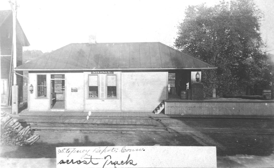
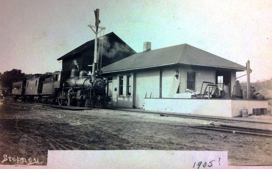
STEPNEY3 [NYNH&H, 1905]
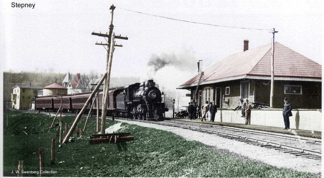
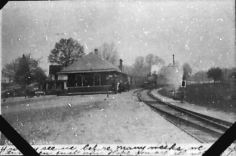
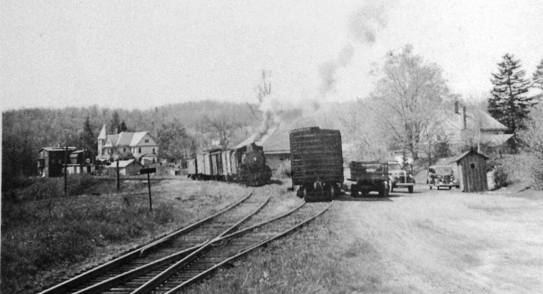
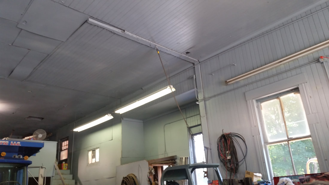
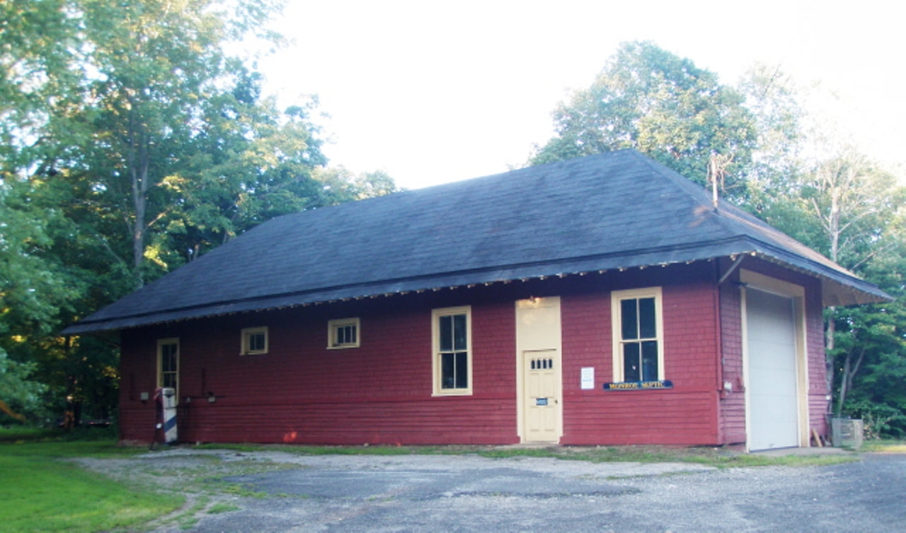
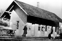
The first intimation we have found of a newer station in the works here comes in 1903 when the Newtown Bee said "... that a new railroad station and freight depot are soon to be erected at Stepney. We trust it may in time, as it has been a long felt need by the public." This station opened on or about 2/13/1905, according to the Bee which said on 2/10 that "wires are being put into the new depot and it now looks as if it would be open to the public by the last of this week..." and on 2/17 that "the new depot was opened to the public, last week." This weekly paper came out on Fridays but was obviously in process in the middle of the week. An article of the 24th said that Station Agent Stephen French, "... a faithful and popular official ... for 22 years in the service of the [rail]road..." had resigned and thus one era ended and another began. We have left Al Weaver's colorization in place to enhance the photo at [1] that shows a train heading for Botsford. If you look closely in the left distance you can see the store with its second-floor bay window projecting over the street. The new water tank that replaced the old one in November, 1906 is beyond the telegraph pole. The photo at [2] shows a train bound for Bridgeport. The newspaper photo at [3] shows a track-side view of the station and ran as part of the lament for the discontinuance of passenger service from Bridgeport to Danbury in 1932. At [4] we see a box car spotted on the house track and a freight engine puffing away with train in tow, possibly in the 1930s. Track was abandoned from Bridgeport in 1940 and service south from BOTSFORD lasted until 1963. A 3/23/1962 CT buildings inventory said that this station and land had been sold. The interior shot at [5] was taken with permission on a 7/11/2014 visit. Aside from the garage door cut into the end, the 55 Maple Dr. structure, seen at [6], looks pretty much the same as it did in 1905. We are at a loss to explain the 1850 date on the nearby historical marker shown at [7] which corresponds neither to the opening of the HRR in 1840 nor to the building of any of the depots here. The narrative is correct and the sentiment well-intentioned. [REFS: NBE/02/10/1905/02; NBE/02/17/1905/02; NBE/03/24/1905/02; CRC53.1905.26; NHAR34.1905.7; NBE/11/06/1906 /02; R96][rev010518]
The first intimation we have found of a newer station in the works here comes in 1903 when the Newtown Bee said "... that a new railroad station and freight depot are soon to be erected at Stepney. We trust it may in time, as it has been a long felt need by the public." This station opened on or about 2/13/1905, according to the Bee which said on 2/10 that "wires are being put into the new depot and it now looks as if it would be open to the public by the last of this week..." and on 2/17 that "the new depot was opened to the public, last week." This weekly paper came out on Fridays but was obviously in process in the middle of the week. An article of the 24th said that Station Agent Stephen French, "... a faithful and popular official ... for 22 years in the service of the [rail]road..." had resigned and thus one era ended and another began. We have left Al Weaver's colorization in place to enhance the photo at [1] that shows a train heading for Botsford. If you look closely in the left distance you can see the store with its second-floor bay window projecting over the street. The new water tank that replaced the old one in November, 1906 is beyond the telegraph pole. The photo at [2] shows a train bound for Bridgeport. The newspaper photo at [3] shows a track-side view of the station and ran as part of the lament for the discontinuance of passenger service from Bridgeport to Danbury in 1932. At [4] we see a box car spotted on the house track and a freight engine puffing away with train in tow, possibly in the 1930s. Track was abandoned from Bridgeport in 1940 and service south from BOTSFORD lasted until 1963. A 3/23/1962 CT buildings inventory said that this station and land had been sold. The interior shot at [5] was taken with permission on a 7/11/2014 visit. Aside from the garage door cut into the end, the 55 Maple Dr. structure, seen at [6], looks pretty much the same as it did in 1905. We are at a loss to explain the 1850 date on the nearby historical marker shown at [7] which corresponds neither to the opening of the HRR in 1840 nor to the building of any of the depots here. The narrative is correct and the sentiment well-intentioned. [REFS: NBE/02/10/1905/02; NBE/02/17/1905/02; NBE/03/24/1905/02; CRC53.1905.26; NHAR34.1905.7; NBE/11/06/1906 /02; R96][rev010518]

|
|
|
STERLING1 [HP&F, 1854]
This stop was established in 1854 when the HP&F opened between Providence and Willimantic. The location in the northwest quadrant of the grade crossing is seen on the 1856WC map at [1]. The first station here was built between the October, 1855 and October, 1856 annual reports. No mention of its fate has been found but it seems to have been replaced in the 1880s by the structure seen in our next entry. Yes, we have no photograph of STERLING1. Interestingly, the shot at [2] has been represented as being Sterling, CT but Lewis H. Benton has the last laugh here. His shot at [3] and his all-important #810 puts it in Sterling, MA as one follows his sequential numbering and geographical wanderings. With the dates he inscribed on some of the photos, it is possible even to narrow the time frame from when he started in 1910 until he stopped ~1935. This one was taken between #742 (7/10/1915) and #819 (10/11/1915), leaning heavily toward early October. The pursuit of Benton has beome rather an obsession with us and has prompted a pending trip to the California State Railroad Museum where the R&LHS collection is said to have many, if not all, his photographs. [REFS: HPFAR6.1855.8; HPFAR7.1856.9][rev013113, 092919]
This stop was established in 1854 when the HP&F opened between Providence and Willimantic. The location in the northwest quadrant of the grade crossing is seen on the 1856WC map at [1]. The first station here was built between the October, 1855 and October, 1856 annual reports. No mention of its fate has been found but it seems to have been replaced in the 1880s by the structure seen in our next entry. Yes, we have no photograph of STERLING1. Interestingly, the shot at [2] has been represented as being Sterling, CT but Lewis H. Benton has the last laugh here. His shot at [3] and his all-important #810 puts it in Sterling, MA as one follows his sequential numbering and geographical wanderings. With the dates he inscribed on some of the photos, it is possible even to narrow the time frame from when he started in 1910 until he stopped ~1935. This one was taken between #742 (7/10/1915) and #819 (10/11/1915), leaning heavily toward early October. The pursuit of Benton has beome rather an obsession with us and has prompted a pending trip to the California State Railroad Museum where the R&LHS collection is said to have many, if not all, his photographs. [REFS: HPFAR6.1855.8; HPFAR7.1856.9][rev013113, 092919]

|
|
Dave Peters Collection
|
|
|
|
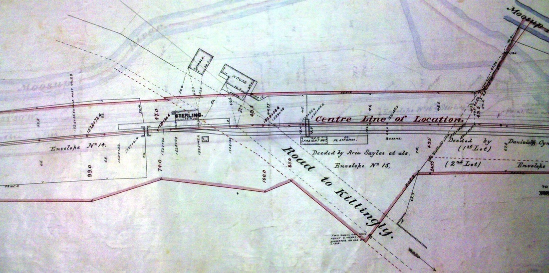
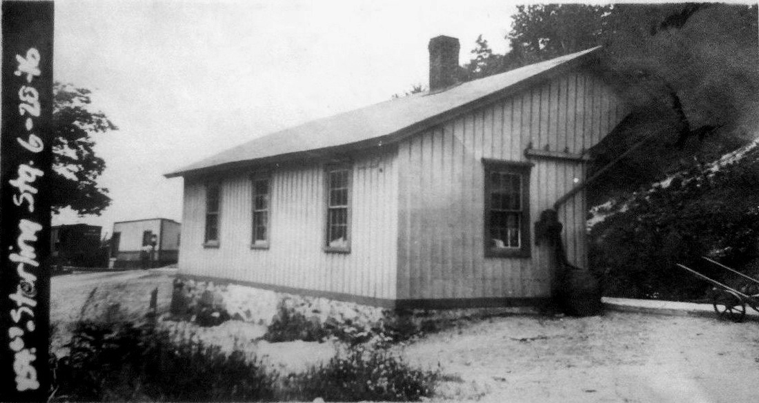
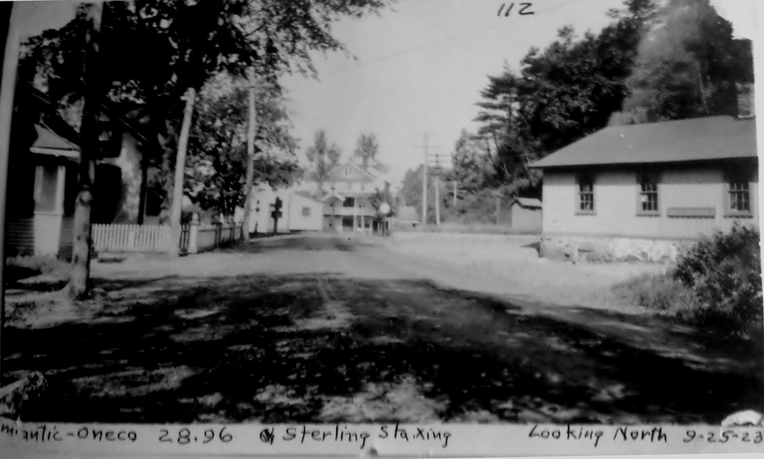
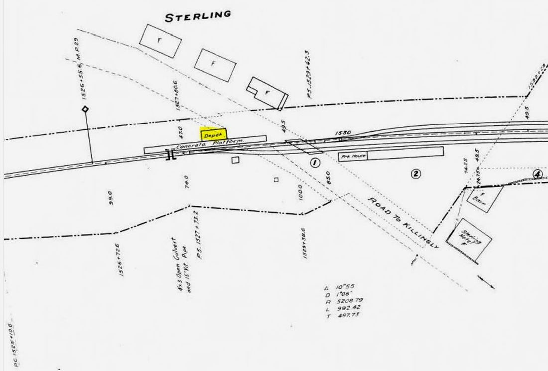
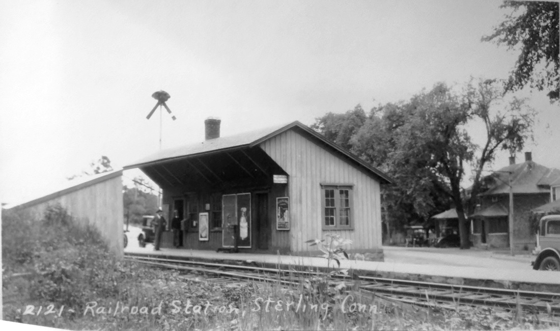
STERLING2 [NYNH&H, c1885?]
The photo at upper left is undated but shows the new depot. The 1886-1889 real estate map at upper middle shows the station now in the southeast quadrant of the grade crossing, with a footprint and location matching the depot in these photos. It probably would had to have been built before 1889 and possibly even before 1886 to have been so depicted on this map. A freight depot was built likely at the same time on the site of STERLING1. The 1915 val map at lower middle shows the layout in that year. The val photo at upper right is dated 6/28/1916 and the PUC shot at lower left was taken on 9/25/1923. The val map at lower middle shows the layout in 1915 and the photo at lower right is a Benton & Drake from the early 1930s. [rev041913]
The photo at upper left is undated but shows the new depot. The 1886-1889 real estate map at upper middle shows the station now in the southeast quadrant of the grade crossing, with a footprint and location matching the depot in these photos. It probably would had to have been built before 1889 and possibly even before 1886 to have been so depicted on this map. A freight depot was built likely at the same time on the site of STERLING1. The 1915 val map at lower middle shows the layout in that year. The val photo at upper right is dated 6/28/1916 and the PUC shot at lower left was taken on 9/25/1923. The val map at lower middle shows the layout in 1915 and the photo at lower right is a Benton & Drake from the early 1930s. [rev041913]
|
|

|
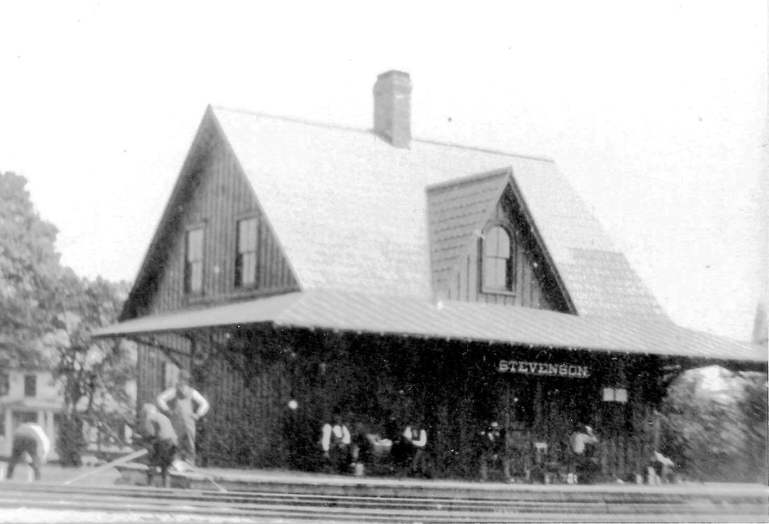
STEVENSON1 [NH&D, 1888; depot 1890]
The Newtown Bee said in April, 1889 that ZOAR BRIDGE, as this locale in the town of Monroe was known before it was named for NH&D Pres. William H. Stevenson out of gratitude for bringing the railroad, was contributing its share of traffic to the new Derby extension but that "some protection from the weather, if only a shed and a platform, would be appreciated..." It went on to say that a comfortable building would probably be erected in the summer. Not so. The Bee then said in November that it had been assured that a station would be built in the fall and "it will be a pretty cottage-like structure, capacious and well arranged and will cost some $700. The double-header side track 600 feet long, was laid last week, ready for the connections... the passenger traffic is already large but will greatly increase when suitable facilities are provided." Again, not so and rumor had it that the NH&D was only going to put up a small depot here. Apparently it took the organization by locals of the Stevenson Station Co. in December, 1889 to assure something fitting to the locale, "... to erect and maintain a station at Monroe on the New Haven & Derby railroad, to be also used as a dwelling house, store and post office; capital stock, $1,000." Fully 17 months after the Extension debuted, STEVENSON1 opened on 6/12/1890 with telegraph instrument and operator ... "and now they have quick communication with the outside world. The grounds around the station are being nicely graded and another switch track is being put in." A chimney fire is thought to have caused STEVENSON1 to burn on 5/19/1905. According to an article in the Stamford Daily Advocate of that day, the 2:00 a.m. down train spotted the flames and blew its whistle to alert the locals who were unable to save the building. Station Agent Goulett, who had until then lived nearby, had just moved a piano and some furniture into the building from his nearby farm, intending to make the station a residence for his family. The various reports give the total loss as $2,000, half for the station which was insured and half for Goulett who was not. His loss included 30 bushels of potatoes in the cellar. For more on this station, see TCS Track 5, MP 5.17-MP 5.20.1. The photo at [1] shows men at work; that is probably Goulett with his arms in a supervisory position. The view at [2] looks railroad west at the station which sat on the north side of the tracks. The shot at [3] is interesting because it shows a photographer with camera and tripod on the platform. Our best guess is that this is from the Hartford Camera Club's 5/30/1890 trip with the depot just about to open officially on 6/12. [REFS: NBE/04/05/1889/04; NBE/11/01/1889/04; NHER/11/18/1889/01; NHER/12/16/1889/01; HC/05/31/1890/05; NBE/02/10/1893/05: Shelton; AES/05/19/1905/13; DEN/05/19/1905/01; STA/05/19/1905 /00; NHJC/05/20/1905/10; HC/05/20/1905/01; NBE/05/26/1905/02][rev011018]
The Newtown Bee said in April, 1889 that ZOAR BRIDGE, as this locale in the town of Monroe was known before it was named for NH&D Pres. William H. Stevenson out of gratitude for bringing the railroad, was contributing its share of traffic to the new Derby extension but that "some protection from the weather, if only a shed and a platform, would be appreciated..." It went on to say that a comfortable building would probably be erected in the summer. Not so. The Bee then said in November that it had been assured that a station would be built in the fall and "it will be a pretty cottage-like structure, capacious and well arranged and will cost some $700. The double-header side track 600 feet long, was laid last week, ready for the connections... the passenger traffic is already large but will greatly increase when suitable facilities are provided." Again, not so and rumor had it that the NH&D was only going to put up a small depot here. Apparently it took the organization by locals of the Stevenson Station Co. in December, 1889 to assure something fitting to the locale, "... to erect and maintain a station at Monroe on the New Haven & Derby railroad, to be also used as a dwelling house, store and post office; capital stock, $1,000." Fully 17 months after the Extension debuted, STEVENSON1 opened on 6/12/1890 with telegraph instrument and operator ... "and now they have quick communication with the outside world. The grounds around the station are being nicely graded and another switch track is being put in." A chimney fire is thought to have caused STEVENSON1 to burn on 5/19/1905. According to an article in the Stamford Daily Advocate of that day, the 2:00 a.m. down train spotted the flames and blew its whistle to alert the locals who were unable to save the building. Station Agent Goulett, who had until then lived nearby, had just moved a piano and some furniture into the building from his nearby farm, intending to make the station a residence for his family. The various reports give the total loss as $2,000, half for the station which was insured and half for Goulett who was not. His loss included 30 bushels of potatoes in the cellar. For more on this station, see TCS Track 5, MP 5.17-MP 5.20.1. The photo at [1] shows men at work; that is probably Goulett with his arms in a supervisory position. The view at [2] looks railroad west at the station which sat on the north side of the tracks. The shot at [3] is interesting because it shows a photographer with camera and tripod on the platform. Our best guess is that this is from the Hartford Camera Club's 5/30/1890 trip with the depot just about to open officially on 6/12. [REFS: NBE/04/05/1889/04; NBE/11/01/1889/04; NHER/11/18/1889/01; NHER/12/16/1889/01; HC/05/31/1890/05; NBE/02/10/1893/05: Shelton; AES/05/19/1905/13; DEN/05/19/1905/01; STA/05/19/1905 /00; NHJC/05/20/1905/10; HC/05/20/1905/01; NBE/05/26/1905/02][rev011018]

|
|
|
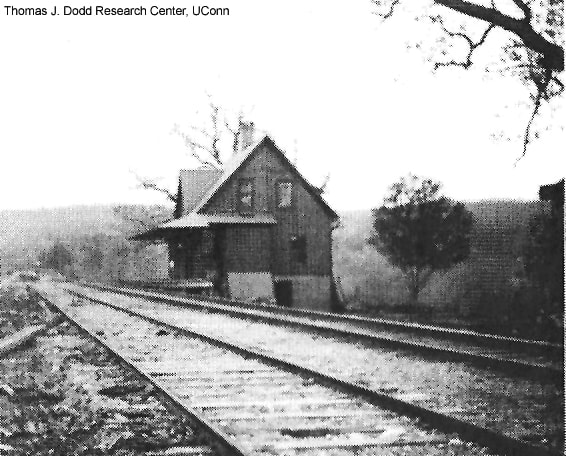
STEVENSON2 [NYNH&H, 1905]
The railroad lost little time in replacing STEVENSON1 and in a very unique way. The Newtown Bee comes to our aid with this report on 8/11/1905: "The foundation for another station to replace the one burned... was begun last week. The station building at Monroe that has been closed the past few years, is to be moved here and placed on the same site of the one burned, but it will be much larger..." and on 8/18 we read that the foundation for the new station "... is nearly completed. [Station Agent] L Goulett has the contract... and has had a large force of men at work on it." The Bee of 9/29/1905 has two relevant articles, the first on p9 saying that the work of rebuilding [our italics throughout] commenced on Monday 9/25. It might ordinarily be thought that this meant replacing the station that was lost but p10 tells us what the carpenters were really doing is piecing together the deconstructed parts of "... the large depot at Monroe [that] has been taken down and was moved here, last week Thursday night [9/21], to take the place of the depot burned a few months ago." The report on 10/20 was that it should be ready in about two weeks. Thus, by early November MONROE2 metamorphosed into STEVENSON2! The val photo at [1] is dated 10/27/1916. Twenty years later local tempers flared here in October, 1937 when the agent, already part-time and visiting for one hour daily to handle the freight business, announced that it was his last day and that the railroad would be closing the station and tearing it down. Shocked locals who recalled earlier days when the station was manned around the clock were told that future freight deliveries would be to BOTSFORD, eight miles away. Passenger service, of course, had ended in 1925. This structure was standing when the 1938 "Status of Structures to be Retired and Removed" was typed and it shows that combination station #4501 was to be disposed of. The final disposition date of STEVENSON2 is unknown. Under successor railroads, service on the Extension lasted until 2011. The 1990s shot at [4] shows a P&W train crossing the Rte 111 bridge just west of the station site. [REFS: NBE/08/18/1905/02; NBE/09/29/1905/02; NBE/10/20/1905/01; NHER/10/15/1937/00; SSRR 1938: yes][rev010418]
The railroad lost little time in replacing STEVENSON1 and in a very unique way. The Newtown Bee comes to our aid with this report on 8/11/1905: "The foundation for another station to replace the one burned... was begun last week. The station building at Monroe that has been closed the past few years, is to be moved here and placed on the same site of the one burned, but it will be much larger..." and on 8/18 we read that the foundation for the new station "... is nearly completed. [Station Agent] L Goulett has the contract... and has had a large force of men at work on it." The Bee of 9/29/1905 has two relevant articles, the first on p9 saying that the work of rebuilding [our italics throughout] commenced on Monday 9/25. It might ordinarily be thought that this meant replacing the station that was lost but p10 tells us what the carpenters were really doing is piecing together the deconstructed parts of "... the large depot at Monroe [that] has been taken down and was moved here, last week Thursday night [9/21], to take the place of the depot burned a few months ago." The report on 10/20 was that it should be ready in about two weeks. Thus, by early November MONROE2 metamorphosed into STEVENSON2! The val photo at [1] is dated 10/27/1916. Twenty years later local tempers flared here in October, 1937 when the agent, already part-time and visiting for one hour daily to handle the freight business, announced that it was his last day and that the railroad would be closing the station and tearing it down. Shocked locals who recalled earlier days when the station was manned around the clock were told that future freight deliveries would be to BOTSFORD, eight miles away. Passenger service, of course, had ended in 1925. This structure was standing when the 1938 "Status of Structures to be Retired and Removed" was typed and it shows that combination station #4501 was to be disposed of. The final disposition date of STEVENSON2 is unknown. Under successor railroads, service on the Extension lasted until 2011. The 1990s shot at [4] shows a P&W train crossing the Rte 111 bridge just west of the station site. [REFS: NBE/08/18/1905/02; NBE/09/29/1905/02; NBE/10/20/1905/01; NHER/10/15/1937/00; SSRR 1938: yes][rev010418]
STILL RIVER [> LANESVILLE AND STILL RIVER]
ICC Collection, National Archives
|

ICC Collection, National Archives
|
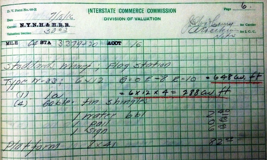
STODDARDS WHARF [NYNH&H, c1900?]
The 7/18/1916 ICC field notes appear to show a 6x12x4-ft gabled structure with a roof of tin shingles, as well as an 8x41-ft platform. The arrangement is shown on the val map at right which says the platform was covered. This was a later stop in the town of Ledyard on the N&W line that was taken over by the NYNH&H in 1898. Our collection shows it first on the 1907 Official List and still on that of 1928, but it no longer appears on our 4/25/1937PTT. We have seen no photographs yet of what the ICC said was a flag stop here in 1916. [rev120312]
The 7/18/1916 ICC field notes appear to show a 6x12x4-ft gabled structure with a roof of tin shingles, as well as an 8x41-ft platform. The arrangement is shown on the val map at right which says the platform was covered. This was a later stop in the town of Ledyard on the N&W line that was taken over by the NYNH&H in 1898. Our collection shows it first on the 1907 Official List and still on that of 1928, but it no longer appears on our 4/25/1937PTT. We have seen no photographs yet of what the ICC said was a flag stop here in 1916. [rev120312]
|
|
|
 Find A Grave
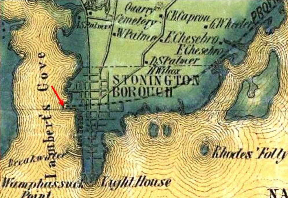
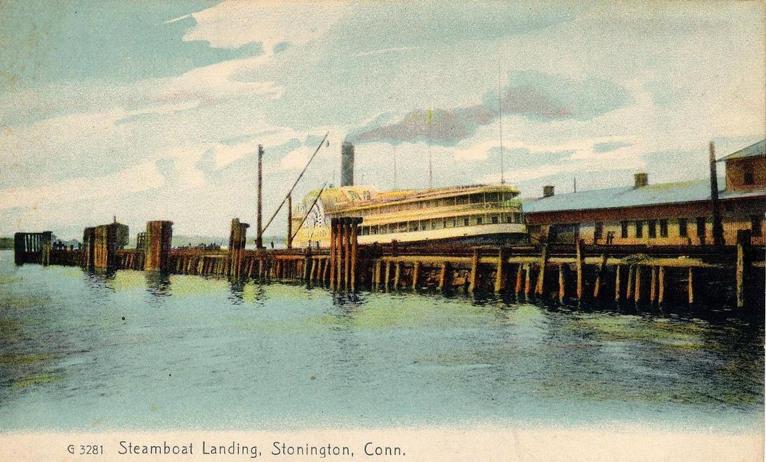
STONINGTON WHARF1 [NYP&B, 1837]
This was at the terminus of the NYP&B at the Stonington Point dock, whence steamboats took passengers and freight to New York. Celebrated civil engineer George Washington Whistler was in charge of the project, later took up residence here, and is buried in Evergreen Cemetery [4]. James McNeil Whistler, his son, is the famed artist who immortalized his mother, George's wife, on canvas. The railroad opened from here to Providence on 11/10/1837 and included the first section of track in the Nutmeg State, though not operated by a Connecticut corporation. The wharf location is seen on the 1854NL map at [1]. The view at [2] is the 1868 Beers map which shows the 1858 extension to Groton Bank diverging at the newly created STONINGTON JUNCTION. The wharf depot and facilities here were abandoned in 1860 for the new ones built opposite New London. The 1866 annual report says that, upon returning here after the 12/29/1865 Groton fire, "the old depot [was] moved up the wharf and fitted up substantially for a car house." The building at our red arrow on the 1879 Bailey bird's-eye map [3] appears to be the structure, however altered subseqently, that served as the first station. The map is from the Boston Public Library. [REFS: CR/11/11/1837/03; NYPBAR 1866, p115 (bd vol); K125][rev122114]
This was at the terminus of the NYP&B at the Stonington Point dock, whence steamboats took passengers and freight to New York. Celebrated civil engineer George Washington Whistler was in charge of the project, later took up residence here, and is buried in Evergreen Cemetery [4]. James McNeil Whistler, his son, is the famed artist who immortalized his mother, George's wife, on canvas. The railroad opened from here to Providence on 11/10/1837 and included the first section of track in the Nutmeg State, though not operated by a Connecticut corporation. The wharf location is seen on the 1854NL map at [1]. The view at [2] is the 1868 Beers map which shows the 1858 extension to Groton Bank diverging at the newly created STONINGTON JUNCTION. The wharf depot and facilities here were abandoned in 1860 for the new ones built opposite New London. The 1866 annual report says that, upon returning here after the 12/29/1865 Groton fire, "the old depot [was] moved up the wharf and fitted up substantially for a car house." The building at our red arrow on the 1879 Bailey bird's-eye map [3] appears to be the structure, however altered subseqently, that served as the first station. The map is from the Boston Public Library. [REFS: CR/11/11/1837/03; NYPBAR 1866, p115 (bd vol); K125][rev122114]
|
|
STONINGTON WHARF2 [NYP&B, 1866]
This new depot was constructed in 1866 as part of the wharf facilities reclaimed here. This was necessary in the wake of the fire at GROTON2 but the NYP&B had already decided to remove its New York boat service back to this port since the change of terminus to Groton had not proven the financial success that had been expected. By July 1, 1866, the new wharf and depot were in service. The 1866 annual report mentions a 57x300-ft structure, "30 feet of which is two-story, the upper floor conveniently fitted up for offices..." The 1868 Beers map of downtown shows the 'Old Depot' and the long new 'Freight and Passenger Depot.' The 1879 Bailey bird's-eye map at [2] gives visual corroboration. Note the full, domed engine house adjacent to the old station. [REFS: MP/12/30/1865/02; NYPBAR 1866, p115 (bd vol)][rev012015]
This new depot was constructed in 1866 as part of the wharf facilities reclaimed here. This was necessary in the wake of the fire at GROTON2 but the NYP&B had already decided to remove its New York boat service back to this port since the change of terminus to Groton had not proven the financial success that had been expected. By July 1, 1866, the new wharf and depot were in service. The 1866 annual report mentions a 57x300-ft structure, "30 feet of which is two-story, the upper floor conveniently fitted up for offices..." The 1868 Beers map of downtown shows the 'Old Depot' and the long new 'Freight and Passenger Depot.' The 1879 Bailey bird's-eye map at [2] gives visual corroboration. Note the full, domed engine house adjacent to the old station. [REFS: MP/12/30/1865/02; NYPBAR 1866, p115 (bd vol)][rev012015]

Edward J. Ozog Collection

|

TCS Collection
|
Edward J. Ozog Collection
|
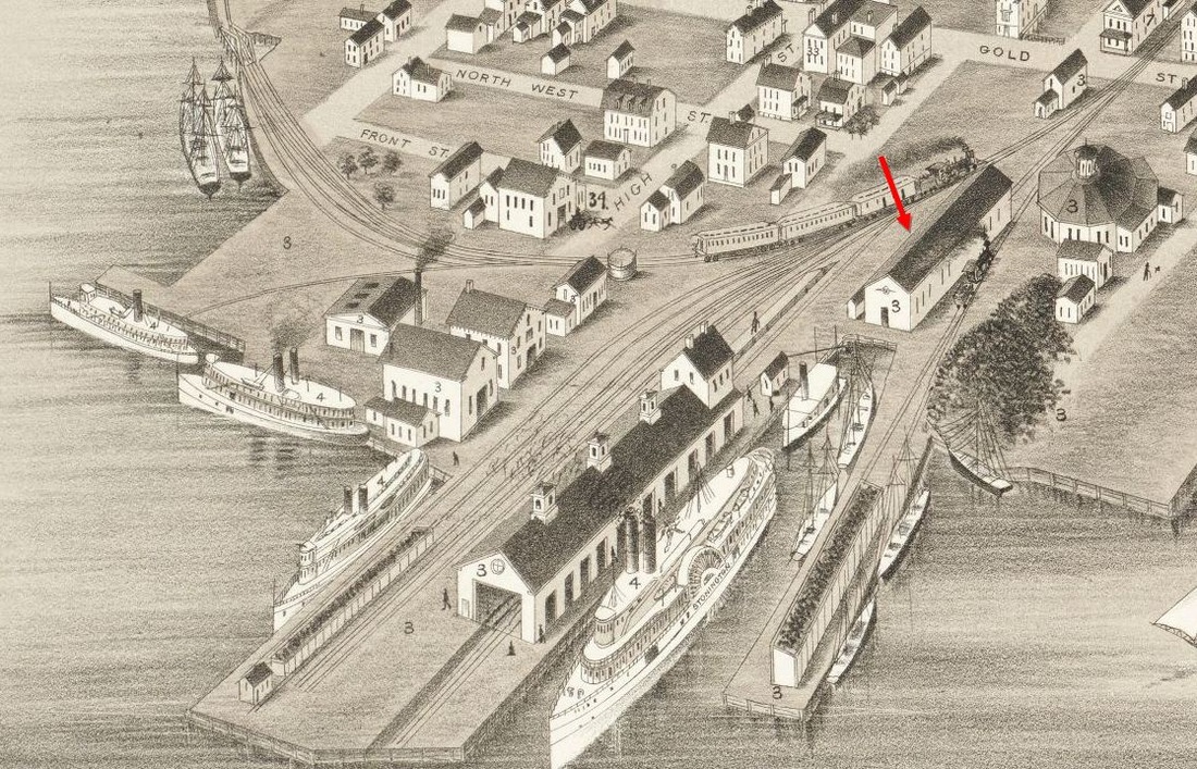
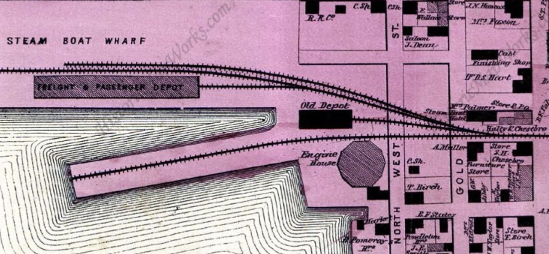
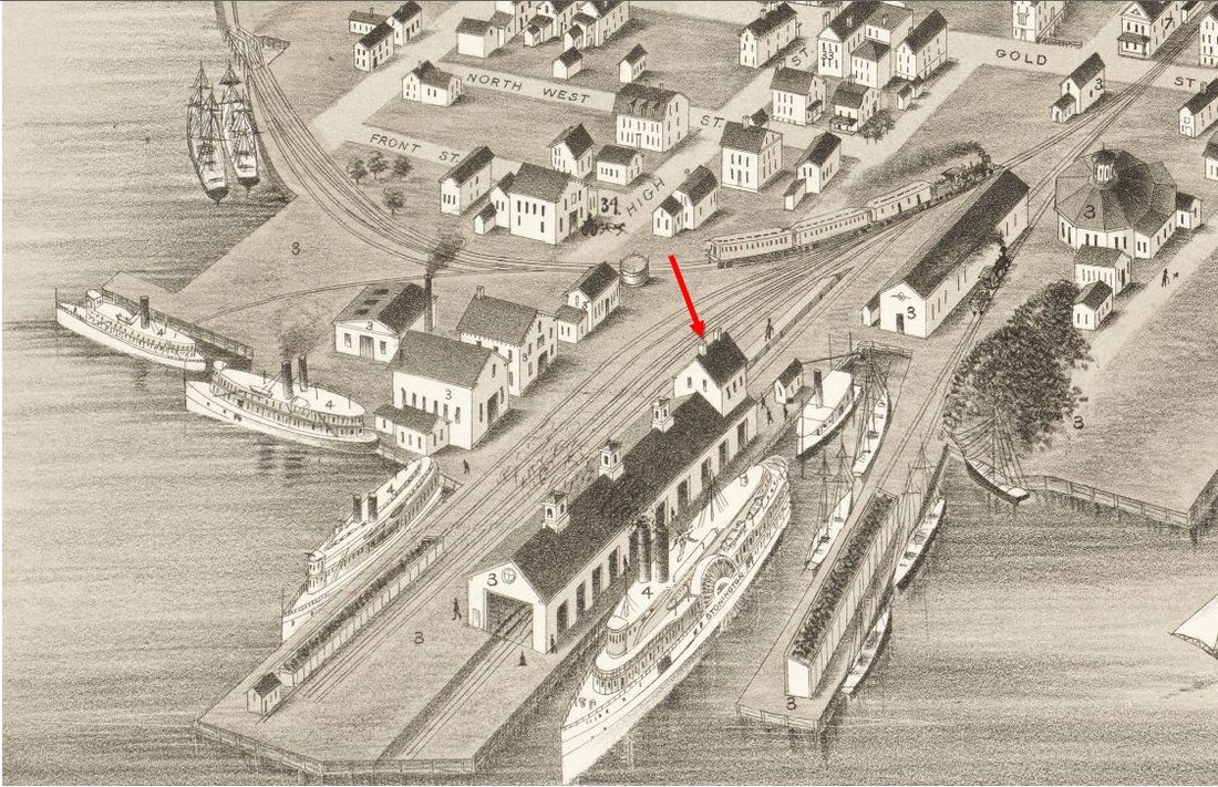
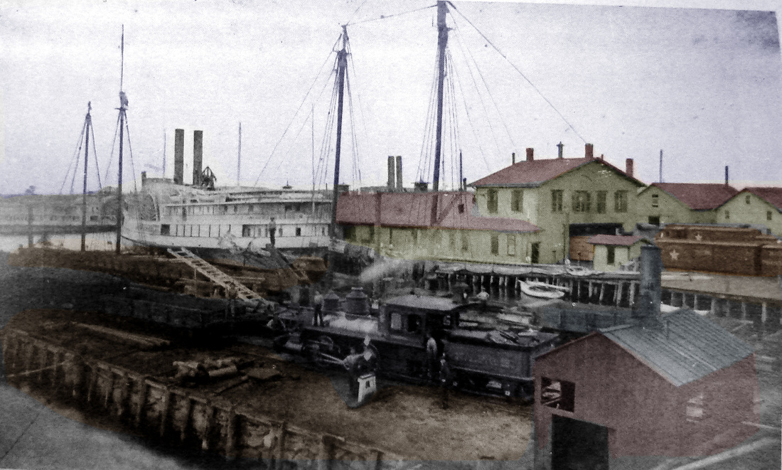
STONINGTON WHARF3 [NYNH&H, 1893]
We can't be completely sure but these images give the appearance of facilities expanded in comparison to those on the Bailey map. The Register reported in 1893 that the railroad "has erected large freight and passenger stations down by the dock..." Whether this meant in that year or in days past is unclear, no mention of any new buildings being found in the annual report of the railroad commissioners or the company itself for 1893 and 1894, but for now we have left this STONINGTON WHARF3 listing in place. The ships at the docks and the bustling activity certainly look more like the early 1890s to us. Boats ceased running from Stonington in 1904 coincident with Pres. Mellen's consolidation of the NYNH&H sea-borne subsidiaries into the New England Navigation Co.; passenger service via boat had been transferred to the Norwich line running out of New London in 1902. Note the NYP&B locomotive working the docks in [5], lettering that indicates a time before or just after the 1893 merger into the NYNH&H. The scene at [6] appears to show the freight yard along the east leg of the Main St. wye. [REFS: NHER/07/31/1893/04; HC/07/12/1902/09; RRG/05/27/1904/ 407; HC/12/09/1904/10][rev071315]
We can't be completely sure but these images give the appearance of facilities expanded in comparison to those on the Bailey map. The Register reported in 1893 that the railroad "has erected large freight and passenger stations down by the dock..." Whether this meant in that year or in days past is unclear, no mention of any new buildings being found in the annual report of the railroad commissioners or the company itself for 1893 and 1894, but for now we have left this STONINGTON WHARF3 listing in place. The ships at the docks and the bustling activity certainly look more like the early 1890s to us. Boats ceased running from Stonington in 1904 coincident with Pres. Mellen's consolidation of the NYNH&H sea-borne subsidiaries into the New England Navigation Co.; passenger service via boat had been transferred to the Norwich line running out of New London in 1902. Note the NYP&B locomotive working the docks in [5], lettering that indicates a time before or just after the 1893 merger into the NYNH&H. The scene at [6] appears to show the freight yard along the east leg of the Main St. wye. [REFS: NHER/07/31/1893/04; HC/07/12/1902/09; RRG/05/27/1904/ 407; HC/12/09/1904/10][rev071315]

|
|

|
|
New London Day
|
|
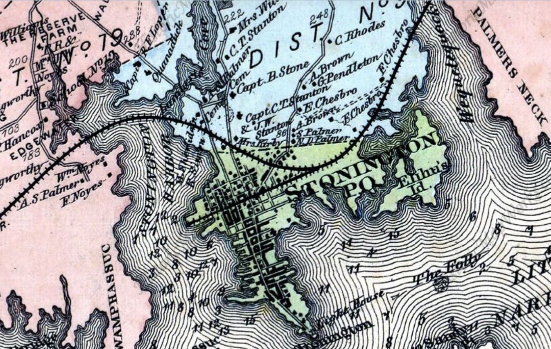
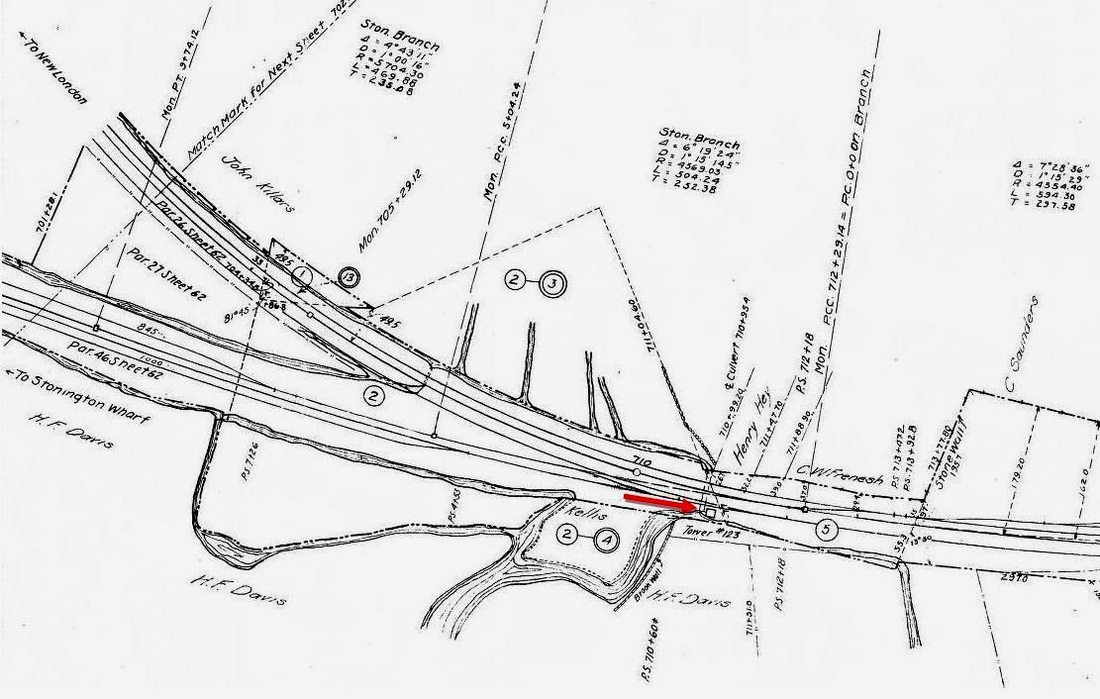
STONINGTON JUNCTION [NYP&B, 1858?]
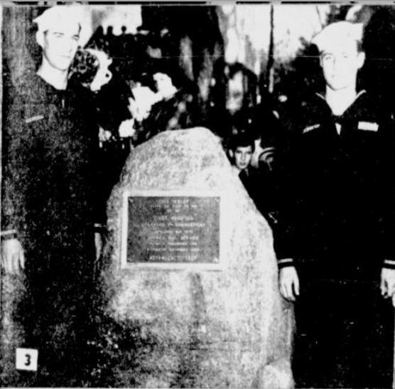
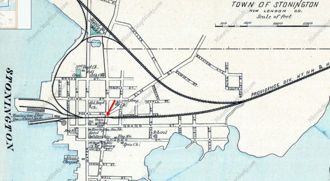
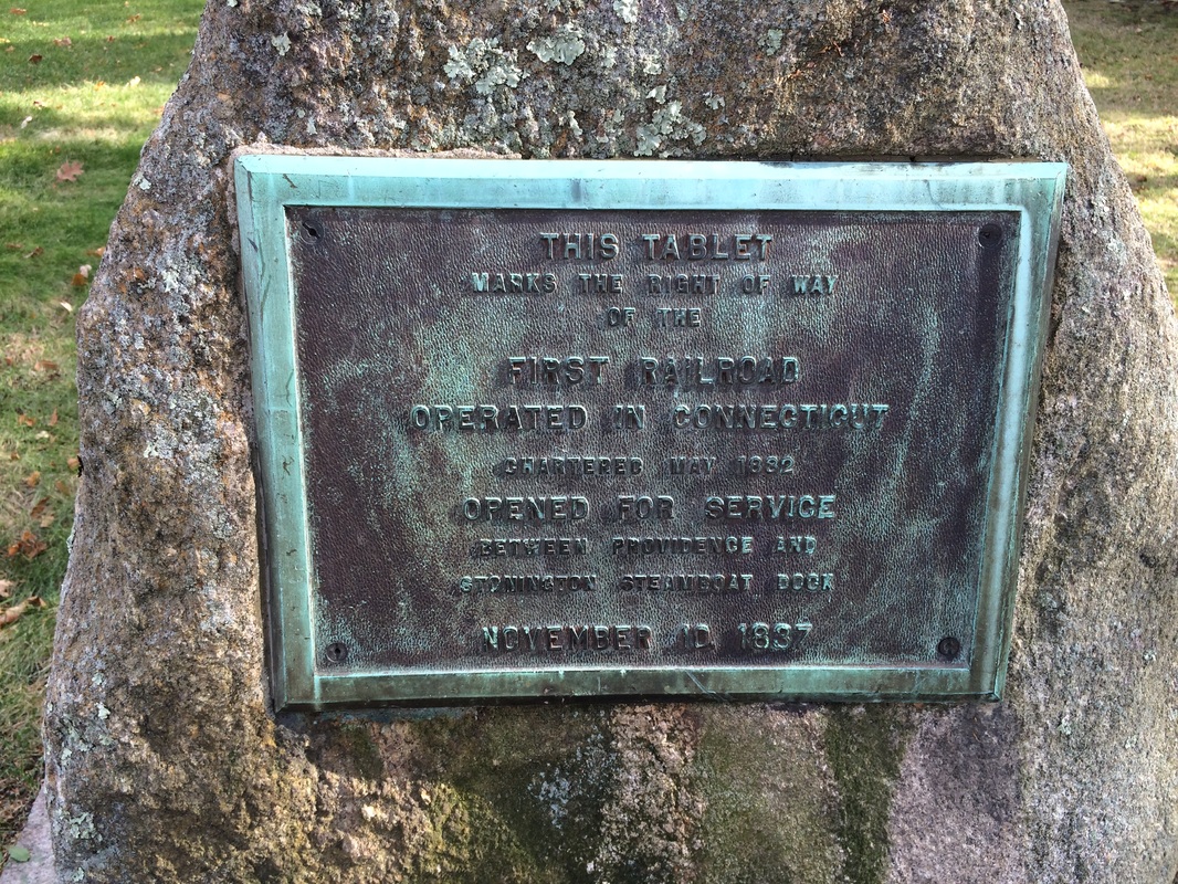
This station probably originated in 1858 about a half mile east of the steamboat dock. There certainly was no real need for a stop here before the junction was created in 1858 with the opening of the new line from this point to Groton Bank. The 1879 Bailey bird's-eye map [1] captures what might well be the depot and timetables in the 1860s and as late as 1881, shown at [2], list it as a passenger stop. From 1837 to 1875, when the Main St. wye connection to the wharf was built, access to the steamboat dock was only from the junction, westbound trains backing out and eastbound trains backing in. After 1875, with entry from both ends, this loop became a convenient arrangement for reversing train directions. SS 123 would stand to guard this junction from 1893 and witness the 7/25/1912 wreck [3] that forced the towerman to jump. The wharf track was abandoned on 9/27/1914 and a new SS 123 erected downtown where it stood south of the track on the east side of Main St. just beyond the STONINGTON2 station. The New London Day reported on 9/28/1914: OLD WHARF LINE OF RAILS TAKEN UP... "The old railroad track from the junction east of the borough to the steamboat dock, crossing Orchard, Main and Water streets, which has been in commission for about half a century, was discontinued on Sunday and the rails were removed. A gang of about 500 workmen was... [also] installing the service of the new interlocking signal tower at the Main St. crossing, the tower of the junction being now permanently abandoned. Hereafter all trains into the freight yards will approach from the west side." The 1915 val map at [4] presents an interesting conflict: it shows SS 123 still at the junction when the newspaper evidence just presented says it was downtown already. We think it is not the first time we have found the ICC efforts not always accurate. The perfunctory 1914 newspaper article misses the date-mark by 22 years and the historical significance of this being part of the first trackage laid in the state, not to mention Mr. Whistler's involvement. In 1937, the main line from the old junction to the steamboat wharf was duly honored with a ceremony and "a bronze tablet set in a boulder" to commemorate the 100th anniversary of railroad service to the town. Owing to the role that the NYP&B played in its history, the NYNH&H had through trains stop here for the observance. The marker was reportedly placed in the cut running by the Second Congregational Church and "faces Main St." The image at [5] shows the tablet flanked by the two local Sea Scouts who presented it and the 1893 map at [6] shows the location. Courtesy of John Roy, the photo at [7] shows the tablet still there today. [REFS: NHER/04/11/1893/01; NLD/09/28/1914/07; HC/10/11/1937/02; HC/10/31/1937 /B8; HC/11/11/1937/15][rev100715]
|
|
|
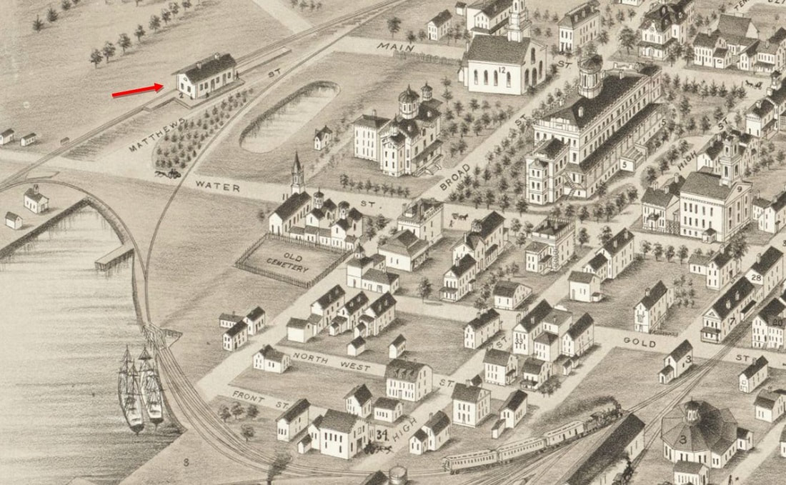
STONINGTON1 [NHNL&S, 1858]
This station was erected at Main and Matthews Sts. when the line from Groton Bank was built; ground was reportedly broken by the NHNL&S on 11/12/1858 on the site of the old Denison salt works. The first train ran through from New York to Boston via the new link and ferry crossing to New London on 12/23/1858. The 1879 Bailey map at [1] shows the station and the larger image at [2] shows 1875 wye curving south and the old main, now the branch track, heading for the wharf. According to the annual report, this new connector, deliberately built from the junction created at the east end of the village, so that the result was "a great decrease in the risk incurred in crossing and recrossing the principal streets of the village," the situation that heretofore existed when trains had to back in and out through town from the old junction. The depot pictured here is presumably the one that burned on 2/11/1897, reported by the Register as follows: "Stonington Station Burned. The Consolidated Railroad's passenger station here was destroyed by fire at 2:30 o'clock this morning, only the west end standing. The fire started in the ticket office from an unknown cause. The discovery was made by the engineer of a passing train who aroused the town with his whistle. The loss on the building is between $2,000 and $3,000; not insured. Private books belonging to Station Agent Crandall and books of the Royal Arcanum, of which Crandall is Secretary, were burned." The Stonington Chronology, a useful compendium of the town's historical events, says: "Feb 11 -- Stonington depot broken into and destroyed by fire. New building constructed by Atwood W. Brayton." Neither the break-in is noted elsewhere nor the role of Brayton, noted local civil engineer, as the rebuilder. The burned station, still sporting its NYP&B compass ornament, is seen at [3]. [REFS: HDC/01/13/1875/04; HDC/05/13/1875/02; NYPBAR 1875, p8; CRC23.1876.21; NHER/02/11/1897/01; HC/02/12/1897/10; SR/02/12/1897/08; NLD/02/12/1897/03; BA51.1898.79; NLD/02/24/1999/C6; William Haynes, Stonington Chronology: Being a Year-by-Year Record of the American Way of Life in a Connecticut Town, 1649-1949. Supplement 1949-1976 by James Boylan. Chester, Connecticut: The Pequot Press, 1976] [rev110815, 112818]
This station was erected at Main and Matthews Sts. when the line from Groton Bank was built; ground was reportedly broken by the NHNL&S on 11/12/1858 on the site of the old Denison salt works. The first train ran through from New York to Boston via the new link and ferry crossing to New London on 12/23/1858. The 1879 Bailey map at [1] shows the station and the larger image at [2] shows 1875 wye curving south and the old main, now the branch track, heading for the wharf. According to the annual report, this new connector, deliberately built from the junction created at the east end of the village, so that the result was "a great decrease in the risk incurred in crossing and recrossing the principal streets of the village," the situation that heretofore existed when trains had to back in and out through town from the old junction. The depot pictured here is presumably the one that burned on 2/11/1897, reported by the Register as follows: "Stonington Station Burned. The Consolidated Railroad's passenger station here was destroyed by fire at 2:30 o'clock this morning, only the west end standing. The fire started in the ticket office from an unknown cause. The discovery was made by the engineer of a passing train who aroused the town with his whistle. The loss on the building is between $2,000 and $3,000; not insured. Private books belonging to Station Agent Crandall and books of the Royal Arcanum, of which Crandall is Secretary, were burned." The Stonington Chronology, a useful compendium of the town's historical events, says: "Feb 11 -- Stonington depot broken into and destroyed by fire. New building constructed by Atwood W. Brayton." Neither the break-in is noted elsewhere nor the role of Brayton, noted local civil engineer, as the rebuilder. The burned station, still sporting its NYP&B compass ornament, is seen at [3]. [REFS: HDC/01/13/1875/04; HDC/05/13/1875/02; NYPBAR 1875, p8; CRC23.1876.21; NHER/02/11/1897/01; HC/02/12/1897/10; SR/02/12/1897/08; NLD/02/12/1897/03; BA51.1898.79; NLD/02/24/1999/C6; William Haynes, Stonington Chronology: Being a Year-by-Year Record of the American Way of Life in a Connecticut Town, 1649-1949. Supplement 1949-1976 by James Boylan. Chester, Connecticut: The Pequot Press, 1976] [rev110815, 112818]
|
|
|
 Stonington Mirror
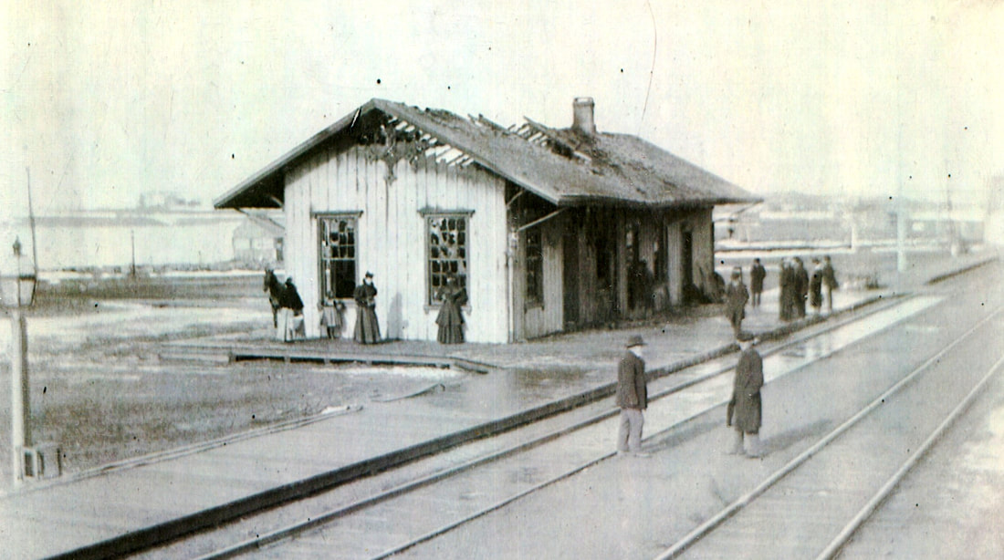
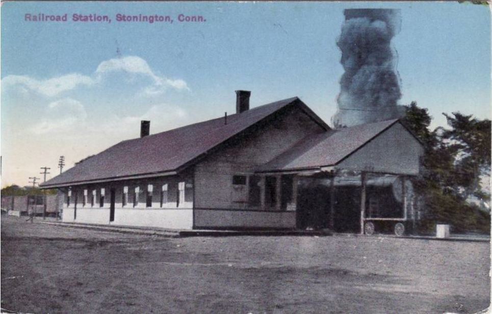
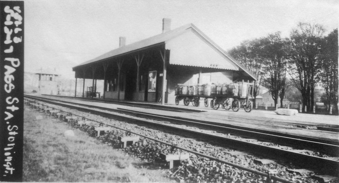
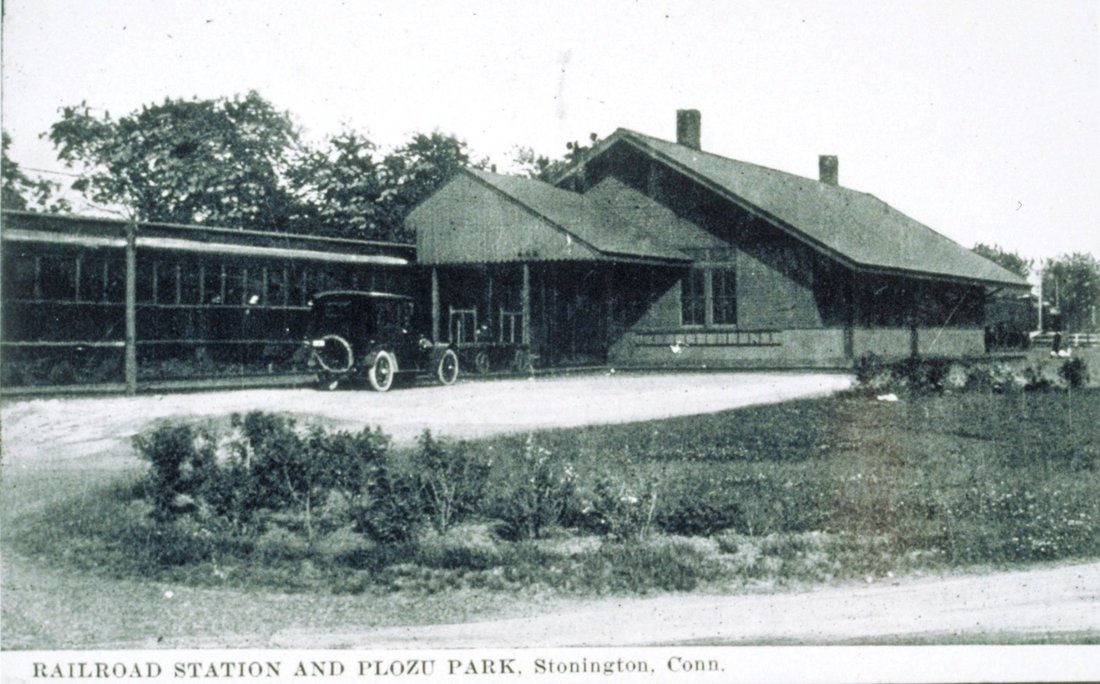
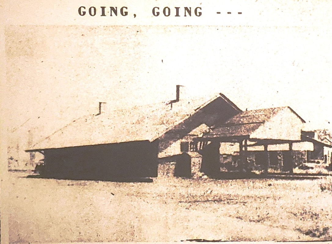
STONINGTON2 [NYNH&H, 1897]
It didn't take long for plans to be drawn up for a new station. The Boston Herald said on 3/18/1897: "Plans are out for the new station at Stonington to take the place of the one recently burned. They show a building 80 feet long and 22 feet wide, and although of wood will be highly ornamented." Based on the early-year announcement of rebuilding plans and a newspaper article of 3/31/1897 which said that much of the framing had been done, we presume completion in April or May, although we find no mention in the annual reports of the railroad commissioners or of the NYNH&H. We are also not sure about the ornamentation but, in a series of Day articles, the newspaper said that Brayton was in charge of the project, "... the toilet rooms are fitted with the latest sanitary devices..., a wash basin is set up in the waiting room... and the new platforms were much wider at 16 feet. Otherwise this looks to us like the standard saltbox design that the railroad was using in the 1890s, which undoubtedly helped with the speed of the rebuild. The coup de grace came when the paper reported that "A handsome new sign arrived here this morning on which is the name 'Stonington' in very large letters of gold. It is to be placed on the new station. The borough has just reason to be proud of all that has been done in this regard and appreciate the fact that the station is an ornament to Stonington." Though the roof of the structure was partially blown off in the 1938 hurricane, STONINGTON2 survived until 1949 when local historian Bob Suppichich says the NYNH&H dismantled it. Sixty years later the glitter had indeed faded. The 7/15/1949 front page of the Stonington Mirror carried a photo, seen at [4], of the old station titled "Going, Going" and with the caption "... The Stonington railroad station is another Borough eyesore which is shortly destined to be eliminated forever. Wreckers began razing the 60 year old building this week to make way for a new station, this bringing to a close the attempts of the Village Improvement Society to have the building painted. The new building will be a three-sided shelter, open on the north side." All the ladies wanted was a paint job? Reaction from the railroad was "Tear it down" in the years after wartime prosperity began to fade. Ironically, Stonington had just celebrated a century of railroad service in 1937 and was just about to celebrate the town's tercentenary in 1949 when their depot was razed. Some anniversary present! To add insult to injury, the NYNH&H announced later in July that service might be reduced from two to one daily stops in the fall, operating losses to blame. The image at [1] may be just after the station opened with the Plozu Park not seen like it is at [3]. The ICC valuation photo at [2] is dated 5/12/1917 and reflects the 9/27/1914 opening of the new concrete SS 123 tower just east of the station to control the interlockings. [REFS: NHER/02/11/1897/01; BH/03/18/1897/08;NLD/03/31/1897/00; NLD/04/02/1897/03; NLD/04/09 /1897/03; NLD/04/15/1897/03; NLD/04/24/1897/03; NLD/04/24/1897/03; NLD/05/13/1897/03; NLD/09/24/ 1914/08; SMI/07/15/1949/01; SMI/07/29/1949/01; SL9.3.10][rev110815,112918]
It didn't take long for plans to be drawn up for a new station. The Boston Herald said on 3/18/1897: "Plans are out for the new station at Stonington to take the place of the one recently burned. They show a building 80 feet long and 22 feet wide, and although of wood will be highly ornamented." Based on the early-year announcement of rebuilding plans and a newspaper article of 3/31/1897 which said that much of the framing had been done, we presume completion in April or May, although we find no mention in the annual reports of the railroad commissioners or of the NYNH&H. We are also not sure about the ornamentation but, in a series of Day articles, the newspaper said that Brayton was in charge of the project, "... the toilet rooms are fitted with the latest sanitary devices..., a wash basin is set up in the waiting room... and the new platforms were much wider at 16 feet. Otherwise this looks to us like the standard saltbox design that the railroad was using in the 1890s, which undoubtedly helped with the speed of the rebuild. The coup de grace came when the paper reported that "A handsome new sign arrived here this morning on which is the name 'Stonington' in very large letters of gold. It is to be placed on the new station. The borough has just reason to be proud of all that has been done in this regard and appreciate the fact that the station is an ornament to Stonington." Though the roof of the structure was partially blown off in the 1938 hurricane, STONINGTON2 survived until 1949 when local historian Bob Suppichich says the NYNH&H dismantled it. Sixty years later the glitter had indeed faded. The 7/15/1949 front page of the Stonington Mirror carried a photo, seen at [4], of the old station titled "Going, Going" and with the caption "... The Stonington railroad station is another Borough eyesore which is shortly destined to be eliminated forever. Wreckers began razing the 60 year old building this week to make way for a new station, this bringing to a close the attempts of the Village Improvement Society to have the building painted. The new building will be a three-sided shelter, open on the north side." All the ladies wanted was a paint job? Reaction from the railroad was "Tear it down" in the years after wartime prosperity began to fade. Ironically, Stonington had just celebrated a century of railroad service in 1937 and was just about to celebrate the town's tercentenary in 1949 when their depot was razed. Some anniversary present! To add insult to injury, the NYNH&H announced later in July that service might be reduced from two to one daily stops in the fall, operating losses to blame. The image at [1] may be just after the station opened with the Plozu Park not seen like it is at [3]. The ICC valuation photo at [2] is dated 5/12/1917 and reflects the 9/27/1914 opening of the new concrete SS 123 tower just east of the station to control the interlockings. [REFS: NHER/02/11/1897/01; BH/03/18/1897/08;NLD/03/31/1897/00; NLD/04/02/1897/03; NLD/04/09 /1897/03; NLD/04/15/1897/03; NLD/04/24/1897/03; NLD/04/24/1897/03; NLD/05/13/1897/03; NLD/09/24/ 1914/08; SMI/07/15/1949/01; SMI/07/29/1949/01; SL9.3.10][rev110815,112918]
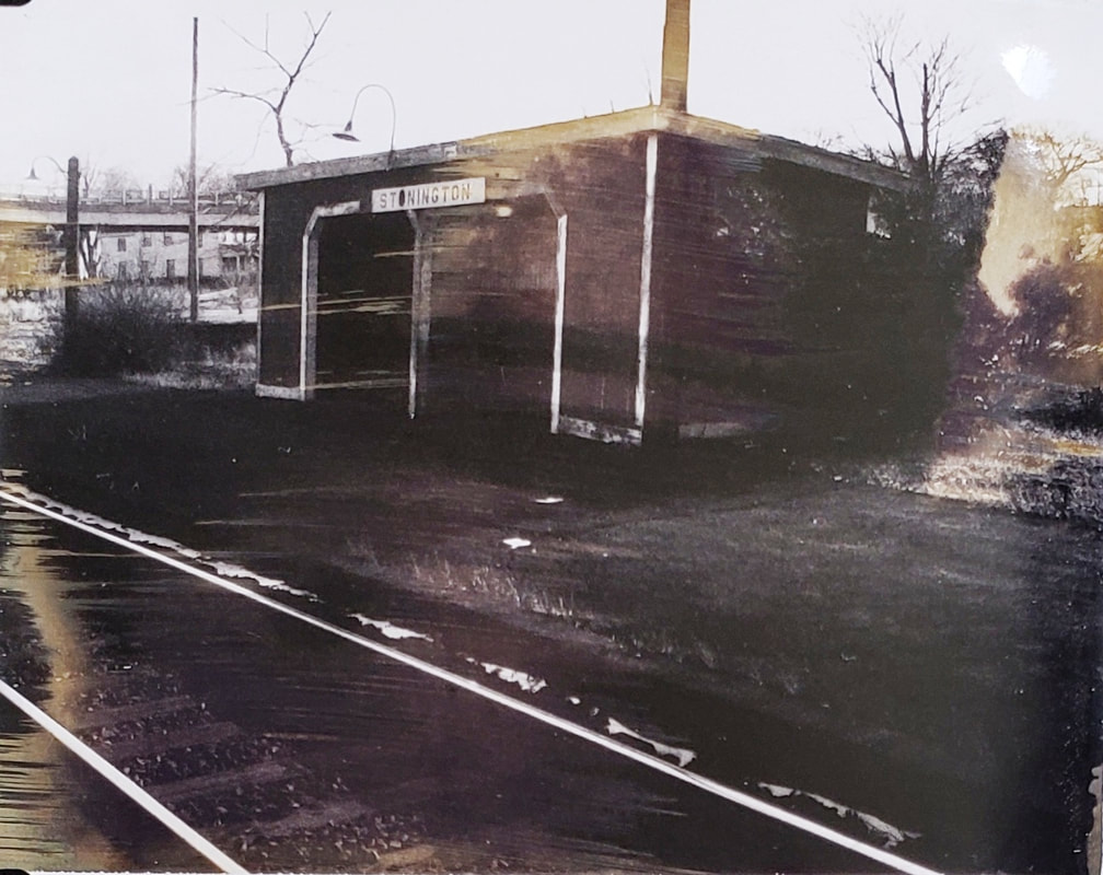
UConn Archives & Spec. Colls.
STONINGTON3 [NYNH&H, 1949]
An interesting article appeared in the Courant in 1973 saying that "the railroad wants to raze shelters and platforms in Stonington, East Lyme, Clinton, Madison and Branford. All are not now in use. Officials say the move has been approved by Amtrak, the national rail passengers corporation. The Shoreline Train Association (STA) is urging the state to buy the sites to keep them for possible return of rail service..." The photo seen here comes from the 1969 NH-PC transfer of real estate assets album. As mentioned in the previous entry, "... The new building will be a three-sided shelter, open on the north side." We could be mistaken but this structure looks to us like it is sitting on the north side of the tracks and the south face of the structure is what is open. [REFS: HC/03/27/1973/13][rev110815, 112818, 080819]
An interesting article appeared in the Courant in 1973 saying that "the railroad wants to raze shelters and platforms in Stonington, East Lyme, Clinton, Madison and Branford. All are not now in use. Officials say the move has been approved by Amtrak, the national rail passengers corporation. The Shoreline Train Association (STA) is urging the state to buy the sites to keep them for possible return of rail service..." The photo seen here comes from the 1969 NH-PC transfer of real estate assets album. As mentioned in the previous entry, "... The new building will be a three-sided shelter, open on the north side." We could be mistaken but this structure looks to us like it is sitting on the north side of the tracks and the south face of the structure is what is open. [REFS: HC/03/27/1973/13][rev110815, 112818, 080819]
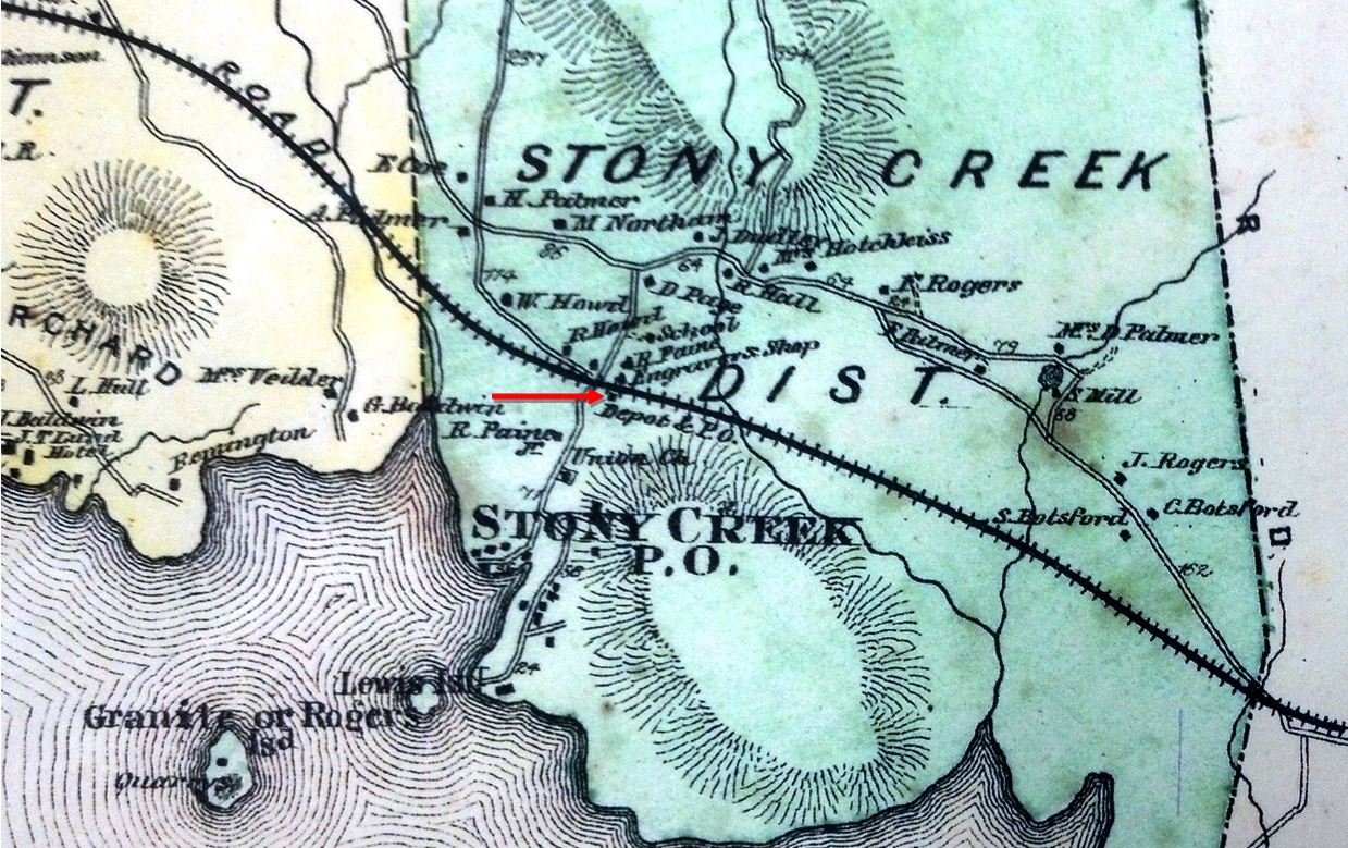
|
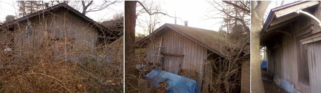
|
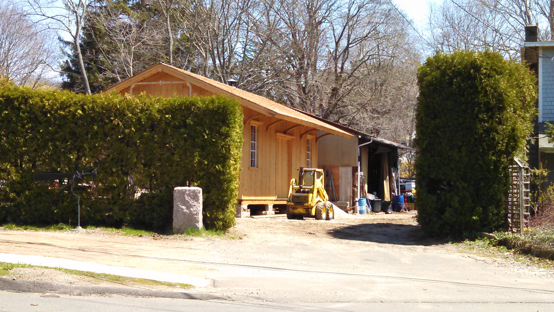
|
|
|
STONY CREEK1 [NH&NL, 1852]
Probably dating to the arrival of the NH&NL in 1852, this original combination passenger and freight depot is still standing off the School St. intersection with Thimble Island Rd. on the railroad's old alignment, in the Stony Creek section of Branford. The 1868 map at [1] shows the location of STONY CREEK1 east of the road and south of the track. STONY CREEK1 was moved west across the road when STONY CREEK2 took its spot in 1883. Then used as the freight station, it also served in 1887 as a makeshift morgue in the murder of Station Agent Charles Ives Way. At some point after its retirement with the 1894 opening of the double-tracked Shore Line, STONY CREEK1 was moved to its third and current location just north of where it stood in 1852. Lee Carlson took the photo at [3] on 4/22/2015; it looks like the property owner was fashioning a facsimile of the depot ahead of the original structure seen behind it. The name of the station and this locale derives from the rock deposits that include the famed pink granite that has been quarried here since the mid-1850s, timing coincidental to the arrival of the railroad and the availability of good transportation. The industry was at its height in the 1890s employing 2,000 workers in several local operations. The old main was left in at the time of the 1894 realignment of the Shore Line to access the quarries and provide a connection with the Stony Creek RR spur which is known today by Quarry Rd. The SCRR, built in 1887 by the Norcross Co., is shown on the 1893 map at [4]. Stone from here went into such projects as the West Point Monument, Grand Central Terminal, and Boston's South Station. For its economic and cultural significance in local history, the Norcross site received an NRHP designation in 2003 [click here]. The image at [5] is from our Track 11 Google Earth map and attempts show the positions of the depots in this village over a century. See LANESVILLE AND STILL RIVER for the only other place we can think of that had more depot relocations than this! [REFS: HDC/08/20/1852/02; HDC/01/13/1859/02; C/09/13/1876/02; NHER/04/06/1883/04; CRC31.1884.20; NHER/12/24/1894/04; NHER/04/10/ 1897/01; H1:340; R96][rev121518]
Probably dating to the arrival of the NH&NL in 1852, this original combination passenger and freight depot is still standing off the School St. intersection with Thimble Island Rd. on the railroad's old alignment, in the Stony Creek section of Branford. The 1868 map at [1] shows the location of STONY CREEK1 east of the road and south of the track. STONY CREEK1 was moved west across the road when STONY CREEK2 took its spot in 1883. Then used as the freight station, it also served in 1887 as a makeshift morgue in the murder of Station Agent Charles Ives Way. At some point after its retirement with the 1894 opening of the double-tracked Shore Line, STONY CREEK1 was moved to its third and current location just north of where it stood in 1852. Lee Carlson took the photo at [3] on 4/22/2015; it looks like the property owner was fashioning a facsimile of the depot ahead of the original structure seen behind it. The name of the station and this locale derives from the rock deposits that include the famed pink granite that has been quarried here since the mid-1850s, timing coincidental to the arrival of the railroad and the availability of good transportation. The industry was at its height in the 1890s employing 2,000 workers in several local operations. The old main was left in at the time of the 1894 realignment of the Shore Line to access the quarries and provide a connection with the Stony Creek RR spur which is known today by Quarry Rd. The SCRR, built in 1887 by the Norcross Co., is shown on the 1893 map at [4]. Stone from here went into such projects as the West Point Monument, Grand Central Terminal, and Boston's South Station. For its economic and cultural significance in local history, the Norcross site received an NRHP designation in 2003 [click here]. The image at [5] is from our Track 11 Google Earth map and attempts show the positions of the depots in this village over a century. See LANESVILLE AND STILL RIVER for the only other place we can think of that had more depot relocations than this! [REFS: HDC/08/20/1852/02; HDC/01/13/1859/02; C/09/13/1876/02; NHER/04/06/1883/04; CRC31.1884.20; NHER/12/24/1894/04; NHER/04/10/ 1897/01; H1:340; R96][rev121518]
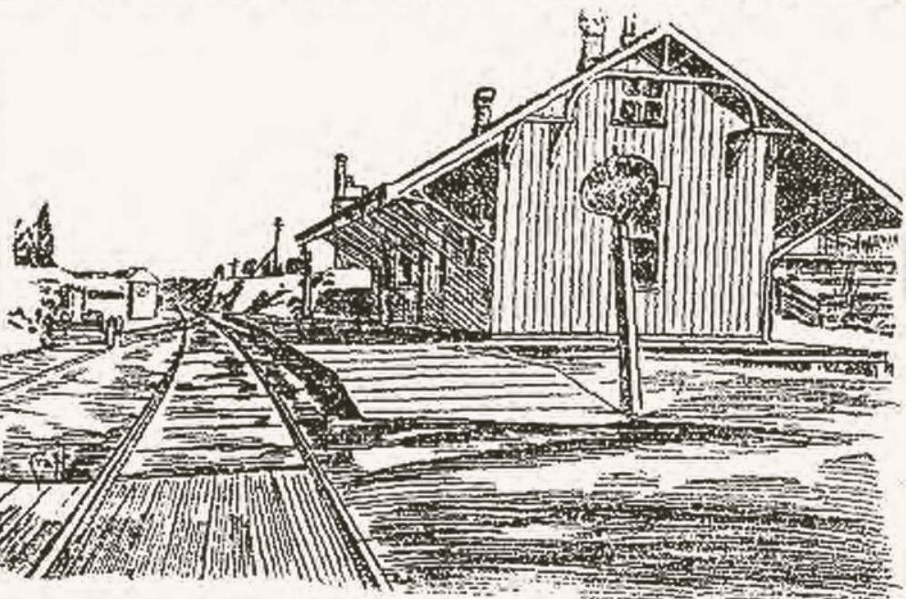
|
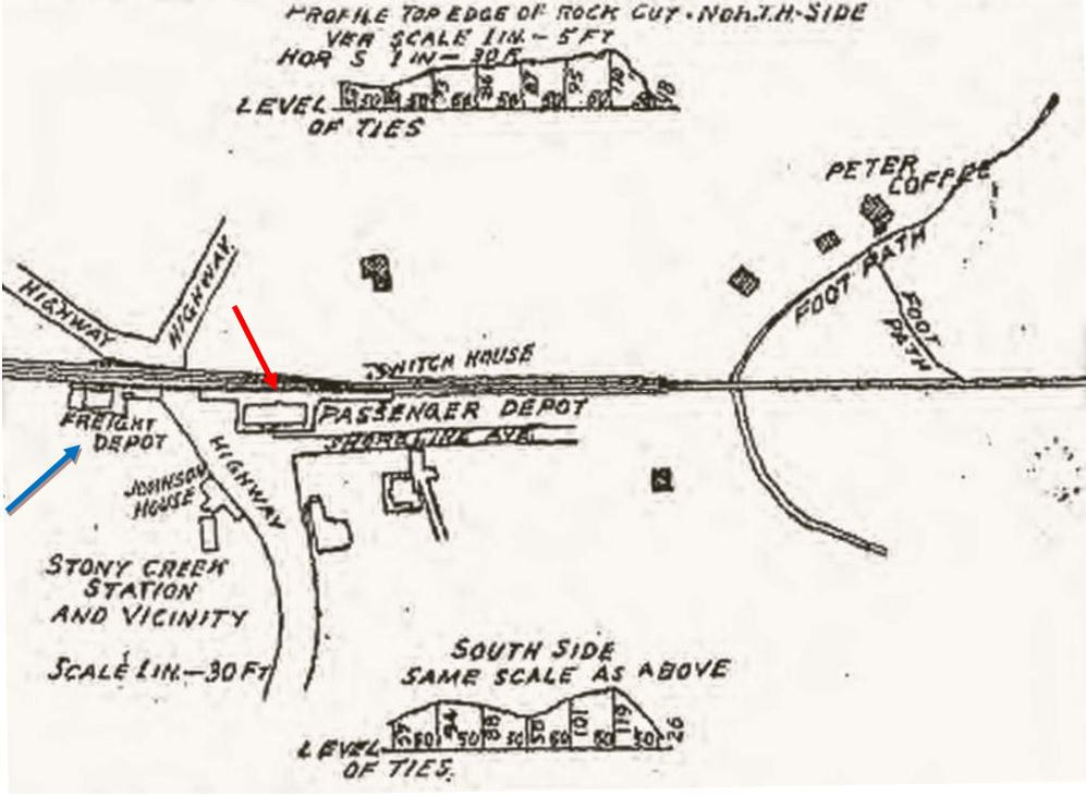
|

|
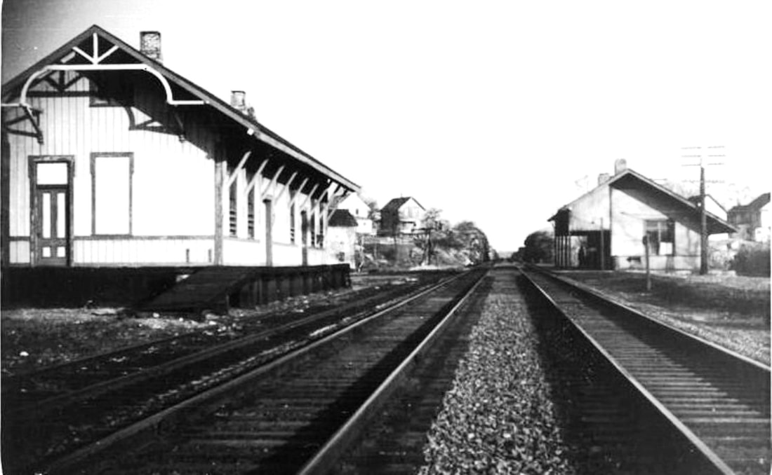
Richard A. Fleischer Collection
|

|
STONY CREEK2 [NYNH&H, 1883]
According to the railroad commissioners, a new passenger station was built here in 1883 at a cost of $2,751. An article in the Register said that the new depot "at last begins to make its appearance" with the lumber having arrived on April 5 and the frame erected the next day. A Register article in June said the new depot was "... now in use [and] is 75x23-ft, with a piazza on all sides, and is furnished in black walnut and yellow pine..." A Register article later in the year credits the prolific William P. Dickerman as the builder, saying that "... few men have built more depots than has Mr. Dickerman." The select construction materials aforementioned and the unique end brackets show an artistry unseen elsewhere. STONY CREEK2 witnessed a shocking event when Station Agent Charles Ives Way was run over by a train and died on the night of 5/9/1887, the eve of his 22nd birthday. The youthful, boyish-faced Way served at FAIR HAVEN and at EAST RIVER (where you can read about his unique rise to notoriety). After his death, the mangled body reposed in STONY CREEK1, then the freight house, until it was brought back to his family for burial. His empty wallet was taken as an indication of robbery and foul play. In a case as notorious as the Stannard and Cramer murders, the NYNH&H even hired a detective, a reporter from the New York World, to go undercover and get evidence. We are fortunate to have the work of the newspaper artist to illustrate the appearance of STONY CREEK2, seen in the eastward looking view at [1] and the map at [2] showing its location where STONY CREEK1 formerly stood [red arrow] before being moved across the street [blue arrow]. The evidence ultimately convicted Peter Coffee, a quarryman, of murdering Way and placing his body on the tracks to mask the crime; Coffee's name purposely appears in the upper left of the map at [2]. He died at the state prison in Wethersfield on 1/15/1889 after only serving a little over a year of a life sentence and maintaining his innocence until the end. Even today, the elements of this case continue to intrigue. The newspaper illustration at [5] appeared on 7/26/1892 and shows the new Shore Line ROW that cut out the meanderings of the old and allowed for the double-tracking. STONY CREEK2 was moved to the north side of the new Shore Line track, likely around June of 1893, and put on a raised platform to serve as the freight house. STONY CREEK2 is seen in an undated photo at [3] and at [4] west of the new salt box-style passenger station. [REFS: HDC/01/13/1859/02; MC/09/13/1876/02; HDC/03/09/1883/00/box??; NHJC/03/28/ 1883/02; NHER/04/06/1883/04; NHER/11/21/1883/01; NHER/12/06/1883/01; CRC31.1884.20; NHER/05/10/ 1887/01; NHER/05/09/1887/01; NYT/05/11/1887/01; NYW/01/20/1888/12; NHER/01/26/1889/01; NHER/07/26/1892/01; R96][rev072713, 121518]
According to the railroad commissioners, a new passenger station was built here in 1883 at a cost of $2,751. An article in the Register said that the new depot "at last begins to make its appearance" with the lumber having arrived on April 5 and the frame erected the next day. A Register article in June said the new depot was "... now in use [and] is 75x23-ft, with a piazza on all sides, and is furnished in black walnut and yellow pine..." A Register article later in the year credits the prolific William P. Dickerman as the builder, saying that "... few men have built more depots than has Mr. Dickerman." The select construction materials aforementioned and the unique end brackets show an artistry unseen elsewhere. STONY CREEK2 witnessed a shocking event when Station Agent Charles Ives Way was run over by a train and died on the night of 5/9/1887, the eve of his 22nd birthday. The youthful, boyish-faced Way served at FAIR HAVEN and at EAST RIVER (where you can read about his unique rise to notoriety). After his death, the mangled body reposed in STONY CREEK1, then the freight house, until it was brought back to his family for burial. His empty wallet was taken as an indication of robbery and foul play. In a case as notorious as the Stannard and Cramer murders, the NYNH&H even hired a detective, a reporter from the New York World, to go undercover and get evidence. We are fortunate to have the work of the newspaper artist to illustrate the appearance of STONY CREEK2, seen in the eastward looking view at [1] and the map at [2] showing its location where STONY CREEK1 formerly stood [red arrow] before being moved across the street [blue arrow]. The evidence ultimately convicted Peter Coffee, a quarryman, of murdering Way and placing his body on the tracks to mask the crime; Coffee's name purposely appears in the upper left of the map at [2]. He died at the state prison in Wethersfield on 1/15/1889 after only serving a little over a year of a life sentence and maintaining his innocence until the end. Even today, the elements of this case continue to intrigue. The newspaper illustration at [5] appeared on 7/26/1892 and shows the new Shore Line ROW that cut out the meanderings of the old and allowed for the double-tracking. STONY CREEK2 was moved to the north side of the new Shore Line track, likely around June of 1893, and put on a raised platform to serve as the freight house. STONY CREEK2 is seen in an undated photo at [3] and at [4] west of the new salt box-style passenger station. [REFS: HDC/01/13/1859/02; MC/09/13/1876/02; HDC/03/09/1883/00/box??; NHJC/03/28/ 1883/02; NHER/04/06/1883/04; NHER/11/21/1883/01; NHER/12/06/1883/01; CRC31.1884.20; NHER/05/10/ 1887/01; NHER/05/09/1887/01; NYT/05/11/1887/01; NYW/01/20/1888/12; NHER/01/26/1889/01; NHER/07/26/1892/01; R96][rev072713, 121518]
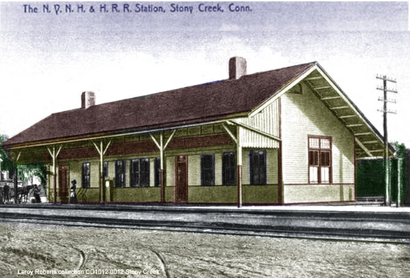
|
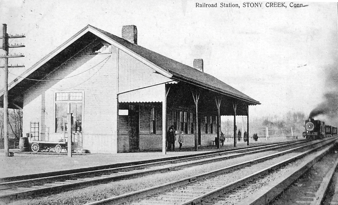
|
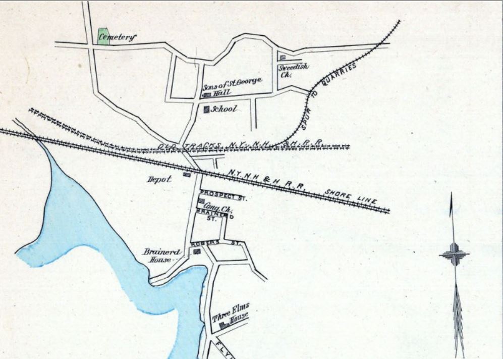
|

|
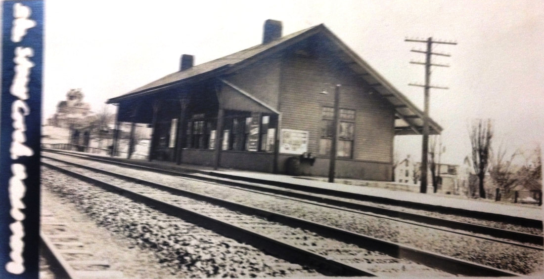
|
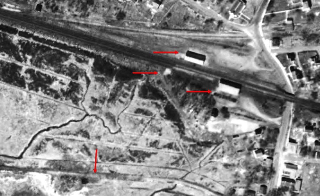
|
STONY CREEK3 [NYNH&H, 1893]
The saltbox-style station, as seen in photos at [1] and [2] stood south of the tracks and show the opposite ends of the structure. The double-tracking of the new Shore Line between PINE ORCHARD and LEETES ISLAND, first opened for use on 6/11/1893, is evident. STONY CREEK3 was likely completed by that date in 1893 and the Hurd map at [3] of that year clearly shows it, but no reference to an actual station opening has been found. The 1915 val map at [4] shows the old right of way curving up to a more northerly route, having been left in place to access the SCRR. The val photo at [5] is undated but others in the area were taken on 9/1/1916. STONY CREEK3 remained in service until early 1948. A Shore Line Times article in December, 1947 says: Railroad Station Sold. In 1899 eleven trains going east and eleven going west stopped at the Stony Creek Railroad Station. Today one train going east and one train going west stopped at the station. Very recently the station has been sold and will be taken down and carted away and only the shed for a shelter will remain on the north side of the tracks..." A Courant article from January, 1948 of that year says that "... the old railroad station has just been torn down, finally succumbing to the inroads of modern motor transportation." Top to bottom arrows on the 1934 aerial map at [6] point to STONY CREEK2 as the freight depot; possibly the Stony Creek tower, SS 90; STONY CREEK3, the passenger station; and at bottom the Branford Electric Rwy curving south to meet the Shore Line Electric Rwy. REFS: NHER/07/26/1892/01; NHER/04/11/1893/01; NHER/06/10/1893/01; SLT/12/11/1947/12; HC/01/25/1948/ SM7; R96][rev121518]
The saltbox-style station, as seen in photos at [1] and [2] stood south of the tracks and show the opposite ends of the structure. The double-tracking of the new Shore Line between PINE ORCHARD and LEETES ISLAND, first opened for use on 6/11/1893, is evident. STONY CREEK3 was likely completed by that date in 1893 and the Hurd map at [3] of that year clearly shows it, but no reference to an actual station opening has been found. The 1915 val map at [4] shows the old right of way curving up to a more northerly route, having been left in place to access the SCRR. The val photo at [5] is undated but others in the area were taken on 9/1/1916. STONY CREEK3 remained in service until early 1948. A Shore Line Times article in December, 1947 says: Railroad Station Sold. In 1899 eleven trains going east and eleven going west stopped at the Stony Creek Railroad Station. Today one train going east and one train going west stopped at the station. Very recently the station has been sold and will be taken down and carted away and only the shed for a shelter will remain on the north side of the tracks..." A Courant article from January, 1948 of that year says that "... the old railroad station has just been torn down, finally succumbing to the inroads of modern motor transportation." Top to bottom arrows on the 1934 aerial map at [6] point to STONY CREEK2 as the freight depot; possibly the Stony Creek tower, SS 90; STONY CREEK3, the passenger station; and at bottom the Branford Electric Rwy curving south to meet the Shore Line Electric Rwy. REFS: NHER/07/26/1892/01; NHER/04/11/1893/01; NHER/06/10/1893/01; SLT/12/11/1947/12; HC/01/25/1948/ SM7; R96][rev121518]

|
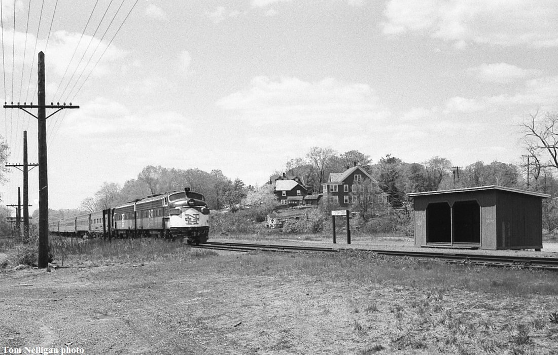
Tom Nelligan photo/NERAIL
|
|
STONY CREEK4 [NYNH&H, 1948]
Working off the previous entry and the article that says "... only the shed for a shelter will remain on the north side of the tracks..." we have to conclude that the shelter was already in place, either being built at this time or possibly earlier as a convenience for passengers taking westbound trains. We were unaware of its existence until a knowledgeable local resident who worked for the NYNH&H told us about it. The photo at [1] showed up in the 1969 NH-PC transfer of real estate assets album. Tom Nelligan took the shot at [2] in June, 1967 showing the New Haven's Boston-bound Colonial passing what he jocularly labels as the 'Stony Creek Union Station.' He says this stop was served at that time by a single weekday New Haven-New London local. That service was taken over by PC as the new operator, as seen in its 2/2/1969 timetable at [3]. The 1965 aerial map at [4] shows the tiny shelter at the lower arrow and the remains of the STONY CREEK3 concrete platform below it; the upper arrow points to the still extant STONY CREEK1 along the original NH&NL ROW. STONY CREEK4 lasted until it was "demolished just after the demise of the Penn Central-operated Amtrak Clamdigger in January 1972," according to our local source. The date may actually be a year later when PC asked for permission to raze other shelters, though it is not mentioned by name with the other stations. Briefly revived Clamdigger service in 1978 seems to have gone station-less here. [REFS: CT aerial map 1965.00094; NH-PC #194; HC/03/27/1973/13][add 110918, rev121518]
Working off the previous entry and the article that says "... only the shed for a shelter will remain on the north side of the tracks..." we have to conclude that the shelter was already in place, either being built at this time or possibly earlier as a convenience for passengers taking westbound trains. We were unaware of its existence until a knowledgeable local resident who worked for the NYNH&H told us about it. The photo at [1] showed up in the 1969 NH-PC transfer of real estate assets album. Tom Nelligan took the shot at [2] in June, 1967 showing the New Haven's Boston-bound Colonial passing what he jocularly labels as the 'Stony Creek Union Station.' He says this stop was served at that time by a single weekday New Haven-New London local. That service was taken over by PC as the new operator, as seen in its 2/2/1969 timetable at [3]. The 1965 aerial map at [4] shows the tiny shelter at the lower arrow and the remains of the STONY CREEK3 concrete platform below it; the upper arrow points to the still extant STONY CREEK1 along the original NH&NL ROW. STONY CREEK4 lasted until it was "demolished just after the demise of the Penn Central-operated Amtrak Clamdigger in January 1972," according to our local source. The date may actually be a year later when PC asked for permission to raze other shelters, though it is not mentioned by name with the other stations. Briefly revived Clamdigger service in 1978 seems to have gone station-less here. [REFS: CT aerial map 1965.00094; NH-PC #194; HC/03/27/1973/13][add 110918, rev121518]
|
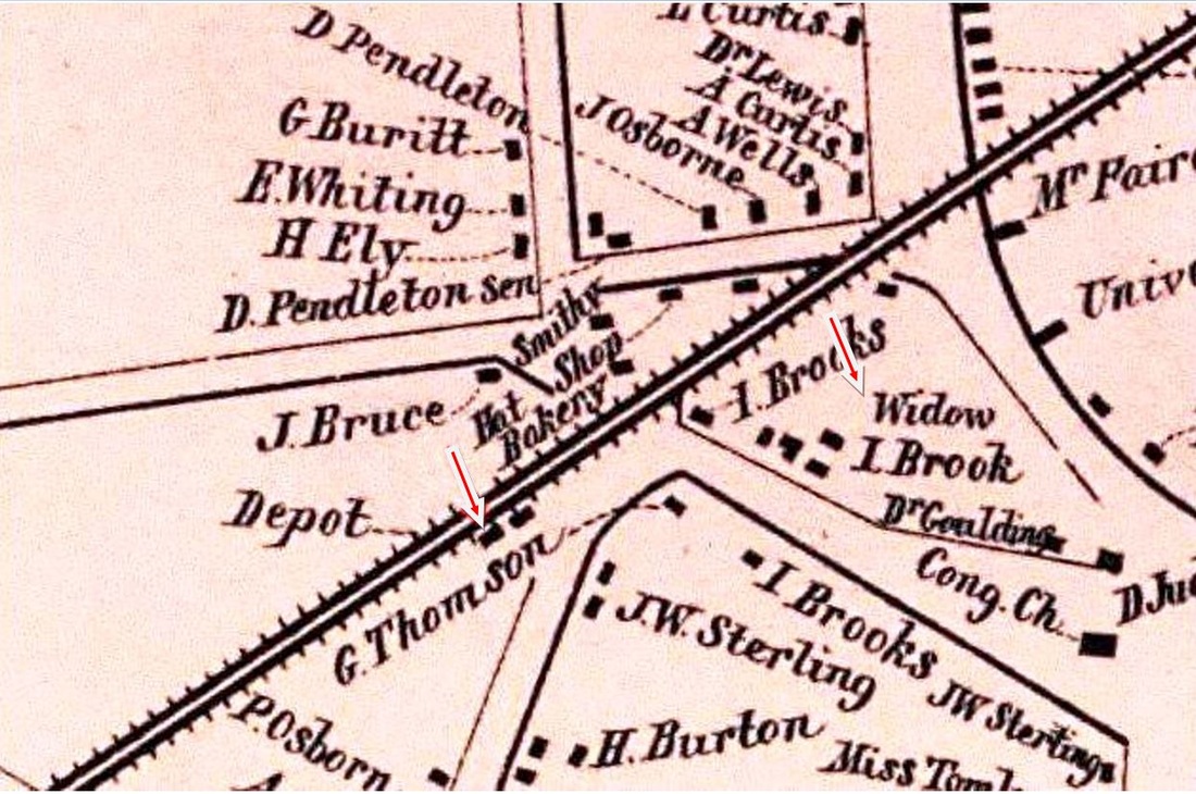
|
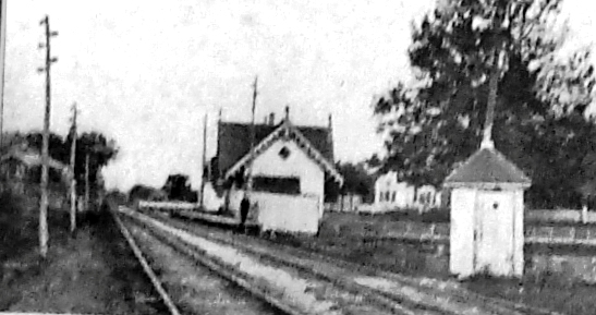
|
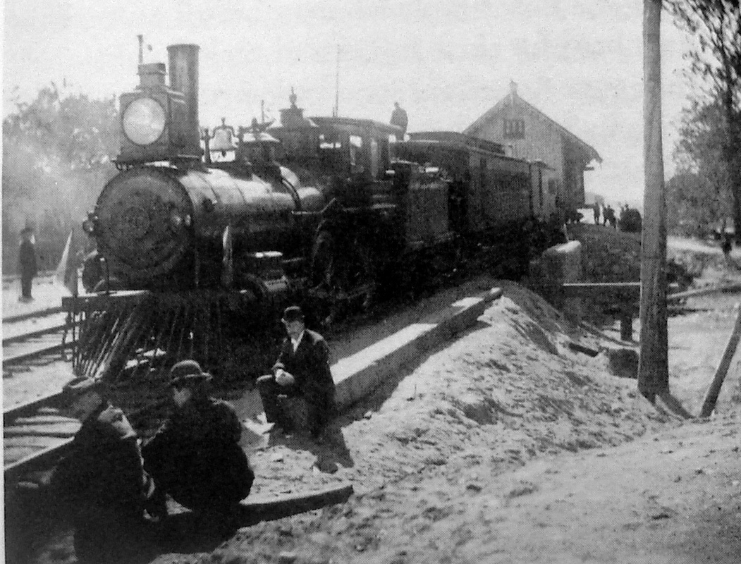
|

|
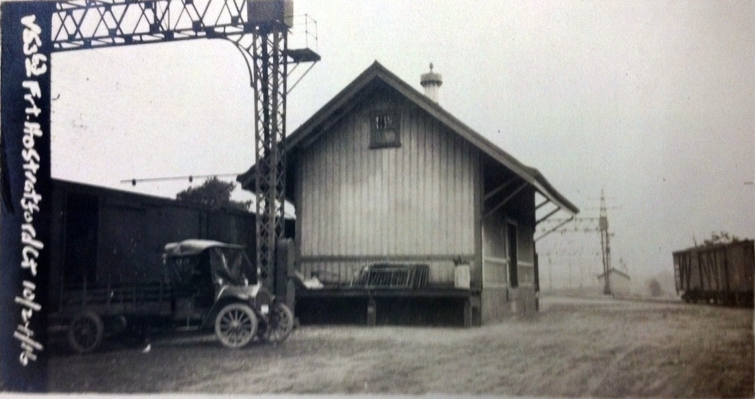
|
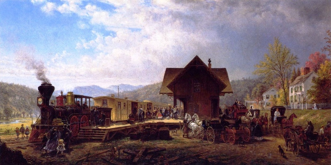
STRATFORD1 [NY&NH, 1848]
Image [1] appears to show this first cross-gabled, Gothic depot in use as a passenger station, making the date prior to 1871 when the next one was built. The location was south of the tracks and west of Main St. on Linden Ave., as seen on the 1856FC map [2]. Photo [3] looks east and dates after the 1858 double-tracking and prior to the new station in 1871. This structure was partially destroyed by a fire in 1882 that probably took out the cross-gable and caused the square window to replace the diamond-shaped one in the west gable. Image [4] shows the depot being moved to a site east of Main St. in 1893. Photo [5] shows this structure as the freight depot in its new location. The wagons are reportedly part of U.S. Army military exercises in 1912 that included an encampment at Tyler City: see Track 1, MP 1.26. Image [6] is the 10/24/1916 val photo. Shot [7] is entitled The 9:45 A.M. Accommodation, Stratford, Connecticut and hangs in the Metropolitan Museum of Art. Edward Lamson Henry painted it in 1867 and, though the mountain background is fanciful and he has taken liberties with some of the depot details, we are assured by the Stratford Historical Society that the homes do correspond to those standing at the time. [rev010914]
Image [1] appears to show this first cross-gabled, Gothic depot in use as a passenger station, making the date prior to 1871 when the next one was built. The location was south of the tracks and west of Main St. on Linden Ave., as seen on the 1856FC map [2]. Photo [3] looks east and dates after the 1858 double-tracking and prior to the new station in 1871. This structure was partially destroyed by a fire in 1882 that probably took out the cross-gable and caused the square window to replace the diamond-shaped one in the west gable. Image [4] shows the depot being moved to a site east of Main St. in 1893. Photo [5] shows this structure as the freight depot in its new location. The wagons are reportedly part of U.S. Army military exercises in 1912 that included an encampment at Tyler City: see Track 1, MP 1.26. Image [6] is the 10/24/1916 val photo. Shot [7] is entitled The 9:45 A.M. Accommodation, Stratford, Connecticut and hangs in the Metropolitan Museum of Art. Edward Lamson Henry painted it in 1867 and, though the mountain background is fanciful and he has taken liberties with some of the depot details, we are assured by the Stratford Historical Society that the homes do correspond to those standing at the time. [rev010914]

|

|
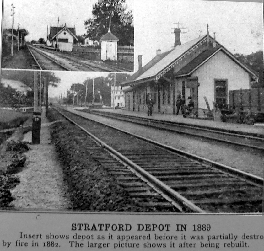
|
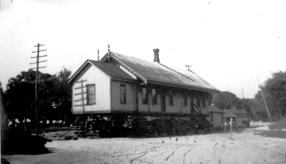
|
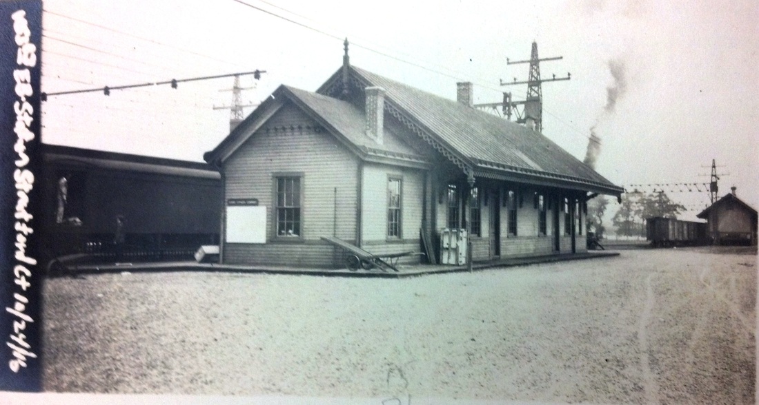
|

|
STRATFORD2 [NYNH&H, 1871]
A 3/1/1871 article in the Palladium tells us that "the New York and New Haven railroad company has concluded to remove the present depot in Stratford to a new foundation, and use it for a freight house, and to erect the new passenger depot on the site of the present one. The new depot will be built somewhat after the plan of the Bridgeport depot, and will be about 70 feet in length." As seen in these photos, this structure was nothing at all like the contemporary station in the Park City, BRIDGEPORT3. A 7/12/1871 article in the Courant does tell us that "the new passenger depot at Stratford on the New York and New Haven road is completed and will be occupied during the present week." This was still at the Linden Ave. location, as seen in image [1] that was taken from the Bailey bird's-eye map of 1882 [click here]. It shows the cross-gabled STRATFORD1, now the freight depot, as well as the new STRATFORD2. Image [2] is probably from the 1880s and [3] reportedly is from 1889, both showing the two structures somewhat closer together than the Bailey snippet. We have been unable to corroborate the 1882 fire mentioned in the captioning but an 11/21/1883 Register article says that well-known contractor William P. Dickerman was about to "build a large addition to the Stratford passenger depot... The present station, although of large size, is not wholly adequate to the wants of patrons of the road." It is unclear if this "addition" refers to the the lower-roofline wing, not particularly large, or to some enlargement of the main depot and nothing is said here of any fire. As early as 1887 surveyors were at work preparing for the four-tracking of the 1890s but the day would not come until 10/01/1893 when the Register reported that both STRATFORD1 and STRATFORD2 were to be jacked up on flat cars "running on both tracks" and to be moved about a third of mile to the east. The job was expected to take a mere two hours! Photo [4] shows workers busy with the project; the station is off the ground! Shot [5] is the 10/24/1916 val photo. Image [6] is a 1950s view. STRATFORD2 serves today as the National Helicopter Museum. [REFS: NYNHAR.1872.11; NHDP/03/01/1871/02; HC/03/03/1871/01; CC/03/11/1871 /04; HDC/07/12/1871/01; NA/07/19/1871/04; NHER/11/21/1883/01; BES/06/13/1887/00; BES/06/24/1887/00; NHER/09/30/1893/04; R97][rev010914]
A 3/1/1871 article in the Palladium tells us that "the New York and New Haven railroad company has concluded to remove the present depot in Stratford to a new foundation, and use it for a freight house, and to erect the new passenger depot on the site of the present one. The new depot will be built somewhat after the plan of the Bridgeport depot, and will be about 70 feet in length." As seen in these photos, this structure was nothing at all like the contemporary station in the Park City, BRIDGEPORT3. A 7/12/1871 article in the Courant does tell us that "the new passenger depot at Stratford on the New York and New Haven road is completed and will be occupied during the present week." This was still at the Linden Ave. location, as seen in image [1] that was taken from the Bailey bird's-eye map of 1882 [click here]. It shows the cross-gabled STRATFORD1, now the freight depot, as well as the new STRATFORD2. Image [2] is probably from the 1880s and [3] reportedly is from 1889, both showing the two structures somewhat closer together than the Bailey snippet. We have been unable to corroborate the 1882 fire mentioned in the captioning but an 11/21/1883 Register article says that well-known contractor William P. Dickerman was about to "build a large addition to the Stratford passenger depot... The present station, although of large size, is not wholly adequate to the wants of patrons of the road." It is unclear if this "addition" refers to the the lower-roofline wing, not particularly large, or to some enlargement of the main depot and nothing is said here of any fire. As early as 1887 surveyors were at work preparing for the four-tracking of the 1890s but the day would not come until 10/01/1893 when the Register reported that both STRATFORD1 and STRATFORD2 were to be jacked up on flat cars "running on both tracks" and to be moved about a third of mile to the east. The job was expected to take a mere two hours! Photo [4] shows workers busy with the project; the station is off the ground! Shot [5] is the 10/24/1916 val photo. Image [6] is a 1950s view. STRATFORD2 serves today as the National Helicopter Museum. [REFS: NYNHAR.1872.11; NHDP/03/01/1871/02; HC/03/03/1871/01; CC/03/11/1871 /04; HDC/07/12/1871/01; NA/07/19/1871/04; NHER/11/21/1883/01; BES/06/13/1887/00; BES/06/24/1887/00; NHER/09/30/1893/04; R97][rev010914]
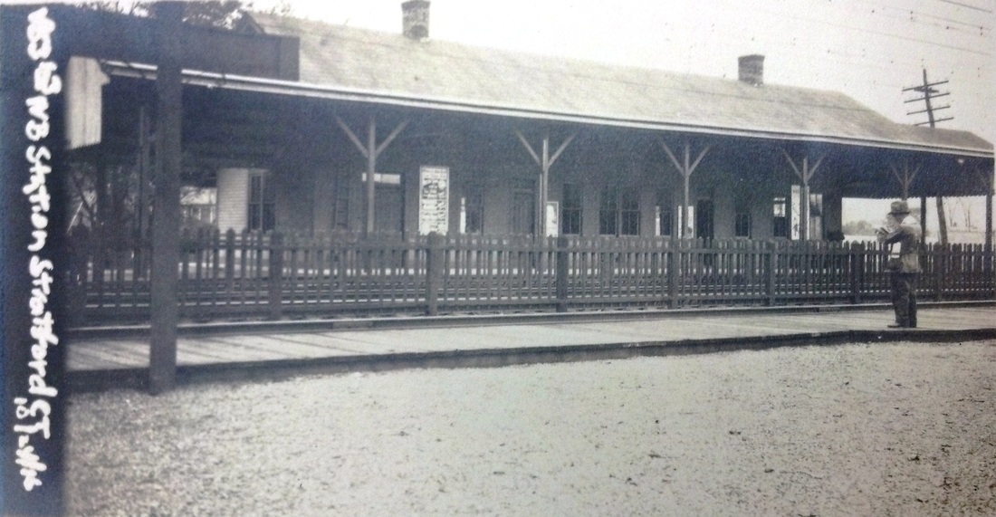
|
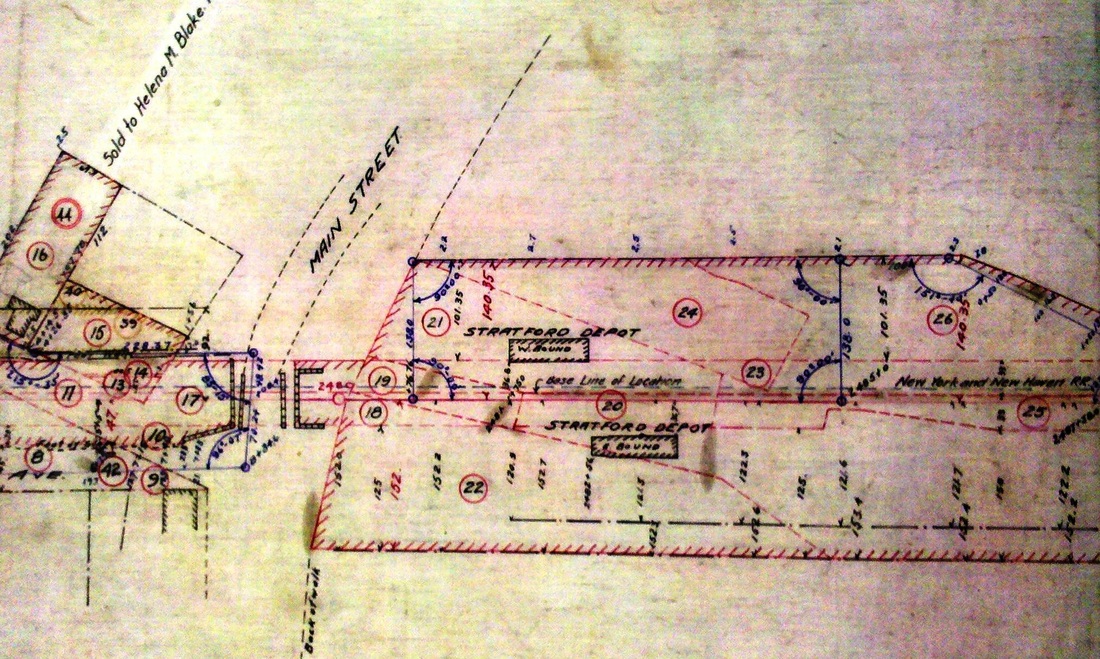
|
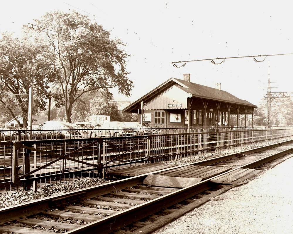
|

Stratford Historical Society
|

|

|
STRATFORD3 [NYNH&H, 1894]
This is the first station to stand on the westbound side, north of the tracks. It was built with the expansion of the New York Division and the four-tracking completed in 1894 from West Haven tower to the Pequonnock River in Bridgeport. Still in railroad use today, the structure also houses a restaurant. Shot [1] is the 10/24/1916 val photo. [2] is from a 1910 railroad real estate atlas. The rest are undated but obviously after the 1914 electrification project. Photo [4] shows a westbound train at the station and the automobiles in [5] date it to the 1950s. The NH block letters on the signboard definitely date the scene to after the McGinnis/Matter era. [REFS: CRC42.1894.17; NHER/09/22/1894/01; NL19.1.4; R97][rev010914]
This is the first station to stand on the westbound side, north of the tracks. It was built with the expansion of the New York Division and the four-tracking completed in 1894 from West Haven tower to the Pequonnock River in Bridgeport. Still in railroad use today, the structure also houses a restaurant. Shot [1] is the 10/24/1916 val photo. [2] is from a 1910 railroad real estate atlas. The rest are undated but obviously after the 1914 electrification project. Photo [4] shows a westbound train at the station and the automobiles in [5] date it to the 1950s. The NH block letters on the signboard definitely date the scene to after the McGinnis/Matter era. [REFS: CRC42.1894.17; NHER/09/22/1894/01; NL19.1.4; R97][rev010914]

|
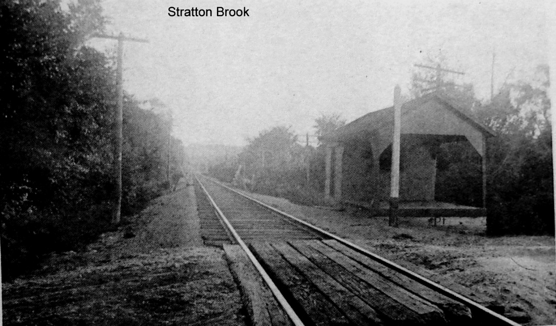
|
STRATTON BROOK [CW, 1871; depot, 1874]
This was an original CW flag stop in the town of Simsbury upon the railroad's opening in 1871. The structure that we see here is probably the one that the newspaper said that the foundation was laid for in 1874, indicating that all that was here previously was a platform of some kind. Interestingly, no structure is listed here by the NY&NE when it was considering a lease of the CW in 1880. This station may also have been known as WEST SIMSBURY, a stop for which we have no other location, and an 1871 article seems to calls it FARMS VILLAGE, 3 miles west of Simsbury. The "large back country" it refers to here was heavily forested at the time and was expected to bring a lot of business to the station. Prominent citizens of "Farmers Village" reportedly fixed up a grove near the station for picnic parties that included a "large substantial dancing platform" with railings, tables, etc. that formally opened on 9/3/1873 and hosted "several hundred, old and young, assembling with a bountiful supply of provisions, and good music." One farmer in 1875 contracted to deliver 22,000 ties to the station for the CW and saw mills and timbering seem to have contributed significantly to industry nearby. The same wooded surroundings also caused this area to be in the news repeatedly for forest fires, as in 1899, 1910 and 1923. The name was changed to STRATTONS per the ICC order of 11/16/1915. The structure reportedly still stood on 10/27/1927 but was gone by 1937. [REFS: WH/05/03/1871/01; HDC/12/14/1871/02; HDC/09/11/1873/01; CWN/11/06/1874/02; WHq/01/29/1875/02; CC/05/01/1875/04; HDC/05/11/1899/05; HDC/04/14/1910/10; HC/04/27/192/01; D21][rev092213]
This was an original CW flag stop in the town of Simsbury upon the railroad's opening in 1871. The structure that we see here is probably the one that the newspaper said that the foundation was laid for in 1874, indicating that all that was here previously was a platform of some kind. Interestingly, no structure is listed here by the NY&NE when it was considering a lease of the CW in 1880. This station may also have been known as WEST SIMSBURY, a stop for which we have no other location, and an 1871 article seems to calls it FARMS VILLAGE, 3 miles west of Simsbury. The "large back country" it refers to here was heavily forested at the time and was expected to bring a lot of business to the station. Prominent citizens of "Farmers Village" reportedly fixed up a grove near the station for picnic parties that included a "large substantial dancing platform" with railings, tables, etc. that formally opened on 9/3/1873 and hosted "several hundred, old and young, assembling with a bountiful supply of provisions, and good music." One farmer in 1875 contracted to deliver 22,000 ties to the station for the CW and saw mills and timbering seem to have contributed significantly to industry nearby. The same wooded surroundings also caused this area to be in the news repeatedly for forest fires, as in 1899, 1910 and 1923. The name was changed to STRATTONS per the ICC order of 11/16/1915. The structure reportedly still stood on 10/27/1927 but was gone by 1937. [REFS: WH/05/03/1871/01; HDC/12/14/1871/02; HDC/09/11/1873/01; CWN/11/06/1874/02; WHq/01/29/1875/02; CC/05/01/1875/04; HDC/05/11/1899/05; HDC/04/14/1910/10; HC/04/27/192/01; D21][rev092213]
SUBMARINE BASE [> NAVY YARD]

|
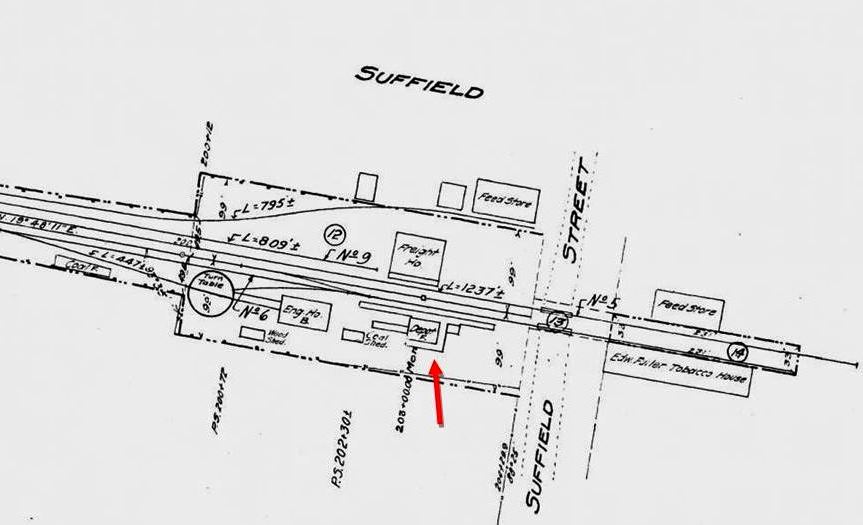
|

|
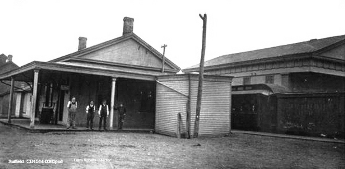
|

|
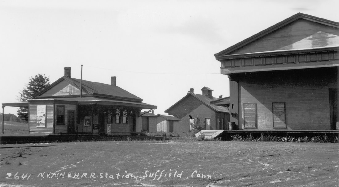
|
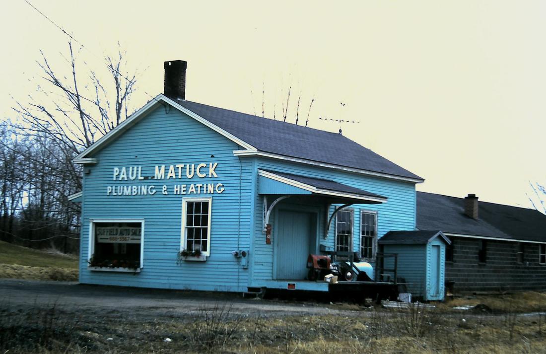 George Ford, Jr. photo
SUFFIELD [WL&S, 1870]
The Windsor Locks & Suffield RR opened on 12/12/1870 when we read that "a pleasant depot building has been erected, with suitable grounds adjoining, on which are a freight house, side tracks, etc., and in a location easy of access from the main street on the hill." Elsewhere we learn that there was a turntable and engine house here, not unexpected for storing and turning trains on this stub-ended line. By early 1871 the branch was reportedly carrying 600 passengers per day to WINDSOR LOCKS via the connection to the H&NH main line. The shot of the passenger depot at [1] is probably ca. 1900. The 1915 val map at [2] shows a tidy yard layout of tracks, railroad structures, plus feed and tobacco storage facilities. The undated Reid postcard at [3] is probably ca. 1919. According to one article there were as many as sixteen trains daily until cutbacks in January, 1909 reduced the number to six, which is the most we have ever seen on a 7/18/1898rev timetable. Competition with the Suffield Street Rwy trolley in 1902 led to mixed-train service with a single combination car for passengers by 1911, perhaps as shown at [4]. A 12/2/1923 timetable shows one daily round trip by that time and passenger service would cease altogether on 1/23/1926 when buses took over; trolley service had already ceased in 1924. The image at [5] shows the facilities on 10/12/1933 with the two-stall engine house in the right foreground. Lewis H. Benton's photo #2641 at [6] dates to June, 1930. Interestingly he shot the reverse view, capturing the north end of the freight house, whose Doric facade betrays its origin as the town's 1835 First Congregational Church. According to an 1870 article in the Massachusetts Spy, "... The old church of the Congregationalists in Suffield will be used as a station for the Hartford and New Haven railroad company on the branch from Windsor Locks to Suffield." The 7/19/1940 SSRR addendum says the passenger station is being retained for use as the freight house and says nothing of the 1835 structure which may have already been sold and moved. While we have heard of church services being held in railroad stations in this state, this is the only use that we know of an ecclesiastical structure as a depot. Skip Ford took the photo at [7] in April, 1970. This building is still standing today but it is inclear if it is the old depot or a replacement built on the old site. [REFS: MSP/01/01/1870/02; BH/02/15/1899/02; BA53.1900.63; SR/07/17/1906/10; HC/01/01/1909/18; HC/03/26/1914/11; HC/05/27/1911/14; SR/05/06/1918/12; HC/07/14/1925/04; SR/01/17/1926/02; HC/04/30/1995/H6; William J. Prendergast, Exploring Connecticut, Pequot Press, 1965, p20][rev010618, 051822, 062423]
The Windsor Locks & Suffield RR opened on 12/12/1870 when we read that "a pleasant depot building has been erected, with suitable grounds adjoining, on which are a freight house, side tracks, etc., and in a location easy of access from the main street on the hill." Elsewhere we learn that there was a turntable and engine house here, not unexpected for storing and turning trains on this stub-ended line. By early 1871 the branch was reportedly carrying 600 passengers per day to WINDSOR LOCKS via the connection to the H&NH main line. The shot of the passenger depot at [1] is probably ca. 1900. The 1915 val map at [2] shows a tidy yard layout of tracks, railroad structures, plus feed and tobacco storage facilities. The undated Reid postcard at [3] is probably ca. 1919. According to one article there were as many as sixteen trains daily until cutbacks in January, 1909 reduced the number to six, which is the most we have ever seen on a 7/18/1898rev timetable. Competition with the Suffield Street Rwy trolley in 1902 led to mixed-train service with a single combination car for passengers by 1911, perhaps as shown at [4]. A 12/2/1923 timetable shows one daily round trip by that time and passenger service would cease altogether on 1/23/1926 when buses took over; trolley service had already ceased in 1924. The image at [5] shows the facilities on 10/12/1933 with the two-stall engine house in the right foreground. Lewis H. Benton's photo #2641 at [6] dates to June, 1930. Interestingly he shot the reverse view, capturing the north end of the freight house, whose Doric facade betrays its origin as the town's 1835 First Congregational Church. According to an 1870 article in the Massachusetts Spy, "... The old church of the Congregationalists in Suffield will be used as a station for the Hartford and New Haven railroad company on the branch from Windsor Locks to Suffield." The 7/19/1940 SSRR addendum says the passenger station is being retained for use as the freight house and says nothing of the 1835 structure which may have already been sold and moved. While we have heard of church services being held in railroad stations in this state, this is the only use that we know of an ecclesiastical structure as a depot. Skip Ford took the photo at [7] in April, 1970. This building is still standing today but it is inclear if it is the old depot or a replacement built on the old site. [REFS: MSP/01/01/1870/02; BH/02/15/1899/02; BA53.1900.63; SR/07/17/1906/10; HC/01/01/1909/18; HC/03/26/1914/11; HC/05/27/1911/14; SR/05/06/1918/12; HC/07/14/1925/04; SR/01/17/1926/02; HC/04/30/1995/H6; William J. Prendergast, Exploring Connecticut, Pequot Press, 1965, p20][rev010618, 051822, 062423]
SUMMIT/CHESHIRE [> EAST SUMMIT]
SUMMIT/NORFOLK [> NORFOLK SUMMIT]
SUMMIT/NORFOLK [> NORFOLK SUMMIT]