Track 4A - NH&D Main Line, New Haven to West Haven
Take a ride on the NH&D main line from the Austin depot in New Haven to the NRR station in Ansonia!
You are now on Track 4A, which runs from New Haven to West Haven.
For a fun, narrated flyover tour of the NH&D main line, click here!
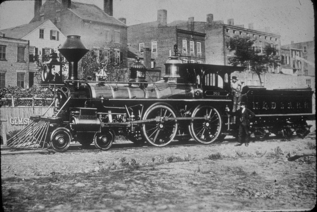
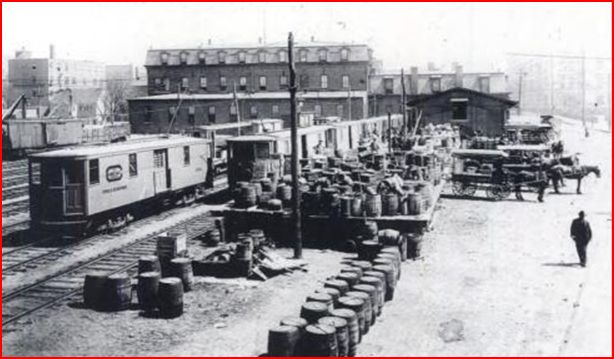
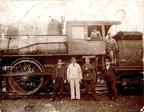
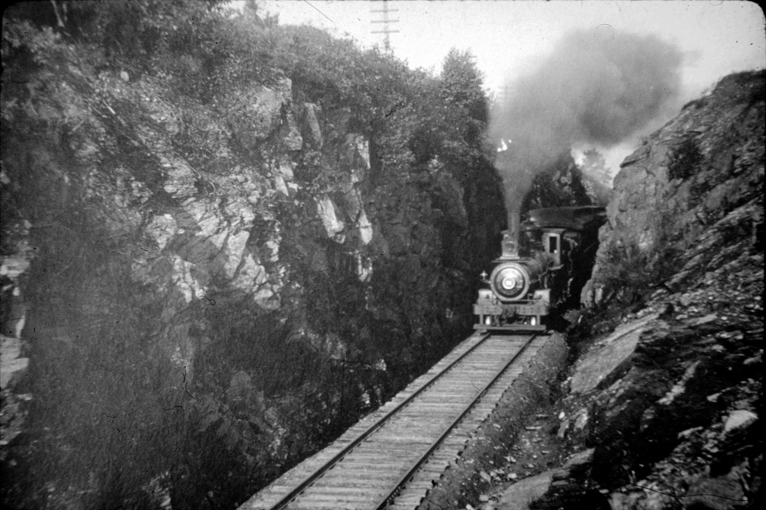
[4.1] The locomotive heading our consist will be NHD&A #1. This 4-4-0 American-type, coal-burning steam engine was produced by Rogers Locomotive Works and was released on February 13, 1871. We are not sure when this shot was taken, but we think it was after a repainting, perhaps after damage due to accidents. See Track 4, MP 3.2.1 for discussion. The scene here is in the Elm City along the track of the New Haven and Northampton RR, also known as the Canal line. Early on, the Derby road used some NH&N trackage and its dock facilities. This location was near the shops of the New Haven Car Co. where the repainting may have been done.
[4.2] Note the 'GEM ST' on the fence above the cowcatcher. This street still exists today off Dixwell Ave. This link should take you there. The engine appears to be facing south and Gem St. is the unpaved road paralleling the track in front of the locomotive. The shot above is from the 1879 bird's-eye map of New Haven [click here]. Gem St. is unlabeled but runs along the track above Goodyear St. seen in the lower left corner.
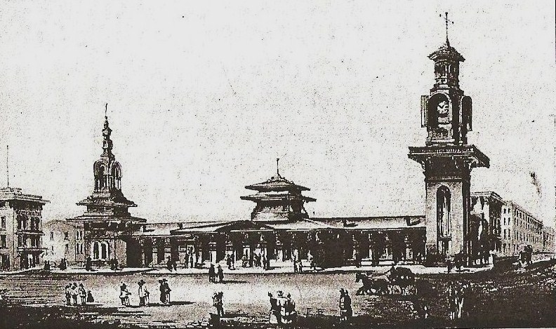
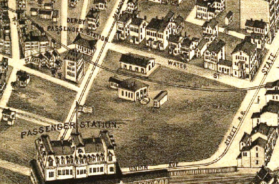
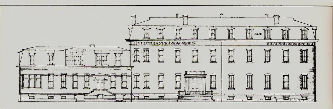
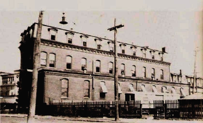
[4.3] Access to the NH&D's first terminus in New Haven was via trackage rights on the Canal road. This was on the westerly of three tracks that sat in the old canal bed under the the Austin depot, pictured above. The depot stood at the corner of Chapel St. (on the right) with the main entrance facing Union St. It was designed by Henry Austin and opened late in 1848.
|

[4.4] This is the same engine as above in what we now think was its appearance as delivered, named the Morris Tyler in honor of the railroad president. It appears to be posing just below the Austin depot. The engine is pointing south and sitting on the westernmost of three tracks where the Derby road actually begins. The NH&D track then curves to the engineer's right to go through Custom House Square.
|
Joe Taylor Collection
|
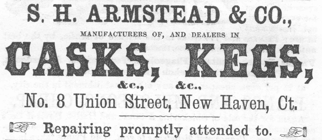
[4.5] The Morris Tyler in the scene above is probably sitting below Fair St. as shown on this shot from the Bailey and Hazen map. S.X. Armstead (S.H. in some city directories), who is advertising his cooperage on the building above the locomotive, had his business at 8 Union St. according to one directory. Many thanks to Joe Taylor, an avid collector of Elm City memorabilia, for supplying what looks like an ad from one of the city directories. The lettering, XON(?), on the fence above the cowcatcher has not yet been explained but the buildings along Union St. appear to be the likely backdrop for the photograph. The large building at the foot of Union St. is the Canal road's 1874 freight house
[4.6] This is reportedly an 1870 Benham city directory map, which actually seems to reflect a slightly later date. Notice the 'new depot' already shown for the planned NYNH&H station at the foot of Meadow St. which would not open until 1875. The NH&D is shown as complete through to the old Austin depot at Chapel and Union Sts. over to the right, but trackage beyond Custom House Square was not installed until just before the NH&D opened in August, 1871. The NH&D track heads west along Silver St.

New Haven Free Public Library
|
|
|
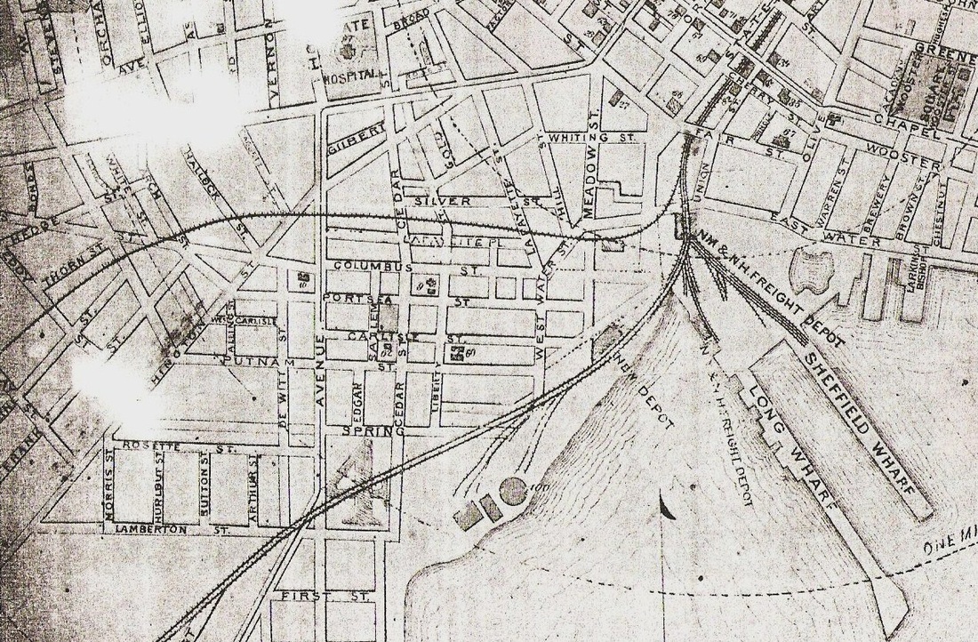
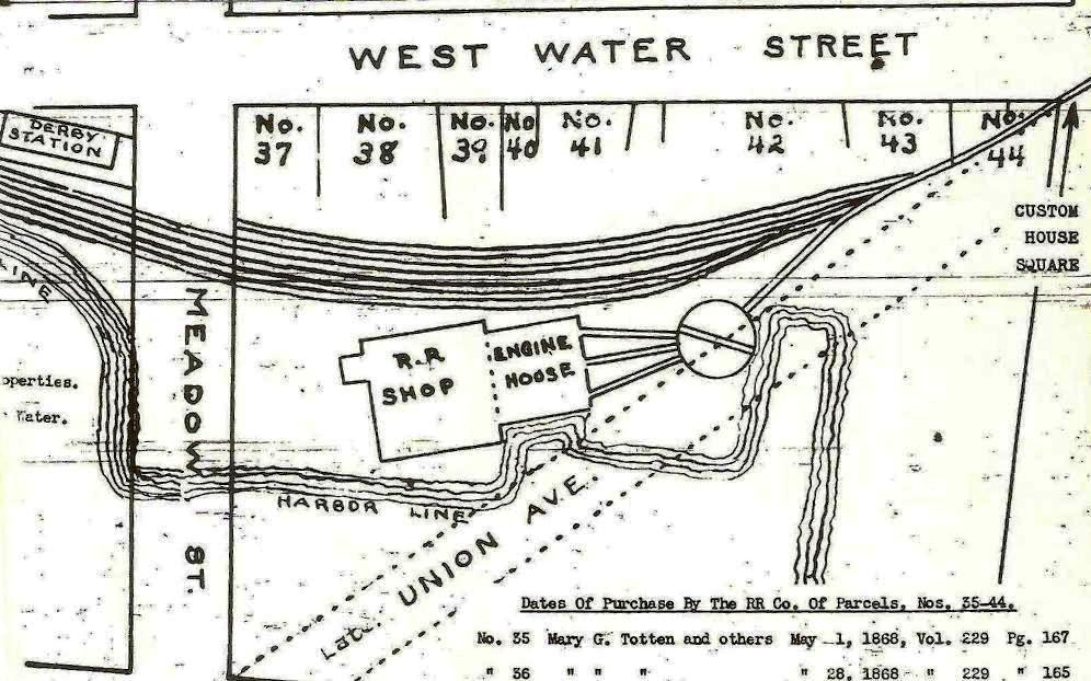
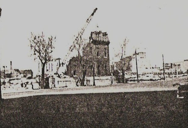
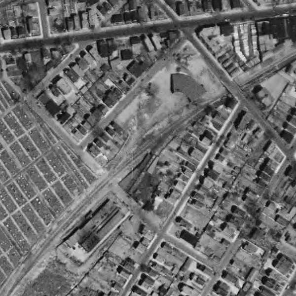
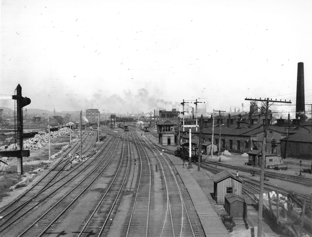
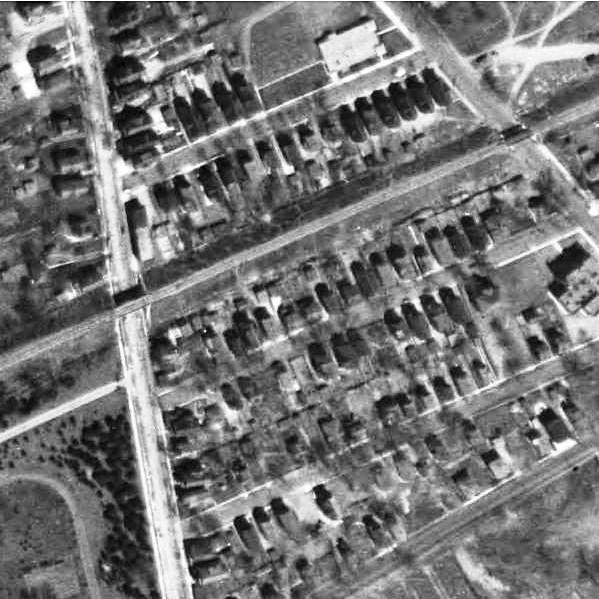
[4.6.1] The shot at [1] appeared in the Register in the 1930s as part of series of photos from bygone days. The single NH&D track is seen crossing the intersection of State and West Water Sts. that was known as Custom House Square, with the corner of the customs building visible at right. The tracks fan out into the small NH&D yard south of West Water St., the photo predating October, 1892 when the ground would be broken for the GOB to be built on the site. The layout corresponds to the real estate map at [2]. To the left is the NH&D three-stall 1873 engine house in front of the car shop. We were thinking that the structure in the center distance, with what appears to be a Mansard roof, is the 1878 NH&D station on the southwest corner of Meadow and West Water, but maps show the building fronting West Water St., not as seen in the photo facing Meadow St. The tall building to the left in photo is on the site where the Hotel Garde would be built in 1894. This photo is the only one we have ever seen of the NH&D's original facilities in New Haven. The shot at [3] is from the 1879 Bailey bird's-eye map which shows the relatively undeveloped site at that time. [rev031616]
Al Lawrence Collection; Copyright NHRHTA
[4.7] This sketch is a front view of the composite NH&D Commerce St. station as it appeared after its debut late in 1888. The two-story wing had been the 1878 NH&D passenger station that stood north of the NH&D track at the southwest corner of Meadow and West Water Sts, (where the NYNH&H's 1947 headquarters building stands today). The 1878 structure was moved across the street to become the NH&D freight office by the end of 1888. We have found an interesting claim in John D. Fassett's UI: History of an Electric Company [p63] that it contracted in January of 1889 with the HRR/NH&D to supply lighting to this depot and freight house for $500 per year. This is corroborated by a Register article that says that the "office, freight house and platforms are lighted at night by numerous incandescent electric lights so business can be carried on with all the conveniences as during the day" [NHER/02/20/1889/01]. If Fassett's 'depot' means the passenger station, then the entire Commerce St. facility was using electricity and was at least in step with the times, and possibly ahead of them, in taking advantage of the technology of the day
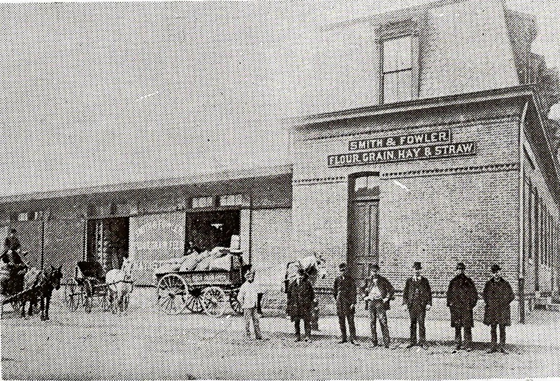
[4.8] This photo ran in the New Haven Register in 1931 as the 107th in its series of pictorial reminiscences that we mentioned above. It shows the two-story freight office, formerly the 1878 NH&D passenger station, rented to Smith and Fowler, grain and feed dealers, to whom the freight depot and probably the platform behind it, were given as well. This was sometime after the NYNH&H takeover of 1892 when the Derby trains went to Union Station instead of here via the West River branch and before the late 1909 use of the south wing for the Conn. Co. trolley express operation, when Smith and Fowler vacated the premises. Previously the express operation had been located on Commerce St. behind the D.M. Welch and Sons grocery store up the street. At the new location adjacent to the RR YMCA, Conn Co. was said to have had more platform and storage space and that its cars would not "conflict" here with the horse-drawn wagons of customers picking up merchandise. See the 1915 valuation map below for the layout at that time

Dodd Center, UConn
[4.9] Here is a front view of the Derby road's Commerce St. station, seen from the corner of Silver St. This building was refitted to open as the NYNH&H's first railroad YMCA on December 28, 1896. [HC/12/30/1896/11; NHDP/12/29/1896/01]. The Courant article carries the texts of the speeches of Vice Pres. Hall and Pres. Clark, the latter of whom said the company's efforts were for the "comfort, rest, amusement and instruction" of the railroad's employees. The annual report for 1897 reported that "twenty bedrooms, six bathrooms, a bowling alley, reading and social rooms were provided at a total cost of $17,800" for the new facility [NHAR26.1897.6]. The plain appearance of the building, the lower-to-the-ground profile, and the lack of a porch at the entrance as seen in later photos would date this shot to the late 1890s or early 1900s.
[4.10] This photo is in the Historical New Haven Digital Collection from Yale [click here] and titled "Railway YMCA Members" with a 1925-1935 date range. To us, the building looks more like the photo above this one than the later view at MP 4.11.2 below. The lower-to-the-street profile and the lack of a porch would seem to argue for pre-1920. The missing plaque may have read New Haven and Derby Railroad Company, perhaps in script herald like the NYNH&H's own. That leads to the exciting possiblity that this could even be around the opening of the new YMCA in 1896. The location seems to be at the entrance to the 1888 wing. The more well-to-do gentlemen may be the board of management [BOM], joined by some regular members and ladies from the women's auxiliary. The YMCA was open to all railroad workers and their families, whether the men were members or not. There is a further possibility that this is the 1889 camera club group seen on Track 5, MP 5.20.2, though no hats or faces yet seem like obvious matches.
Orange Historical Society
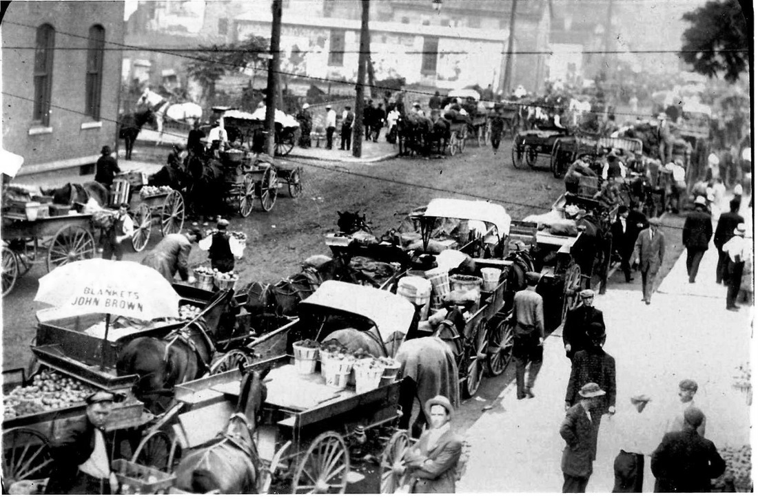
[4.11] New Haven's peripatetic produce market has taken up residence at Silver and Commerce Sts. and business is in full swing here. The white warehouse building in the background sports the same Ringling Bros. circus ad as seen in the next photo. The horse and wagon transportation modality is in evidence and Commerce St. does not appear to be paved yet. The corner of the RR YMCA is visible to the left and this appears to be prior to the backward relocation of the building in 1920. [rev120813]

[4.11.1] This historic shot shows the RR YMCA being moved backward for the widening of Commerce St., renamed South Orange St. to serve as the approach to the new 1920 Union Station. The move was made in May, 1920 [NHER/05/10/1920/01; NHER/05/11/1920/01; NHER/06/01/1920/01]. The YMCA records say that the men were going to sleep at the Silver St. freight house while the work was completed. As with the other construction projects in this area of 'made' land, the discovery of water and quicksand beneath the surface necessitated pilings under the new foundation, perhaps accounting for its higher elevation. As the exterior is seen here, there is no fire escape yet on the south end, though it looks like the triple-paned window on that end has perhaps just been put in. The contractor's name on the banner is John Eichleay, Jr. of Pittsburgh, Pennsylvania. We wonder why someone from so far away was chosen for this job, though perhaps special expertise was needed to move a structure of this size, comprised no less of two buildings that were constructed separately and joined later. The physical operation looks like it is being done with railroad tracks and car-wheel trucks, and perhaps locomotive power in the Silver St. yard. The building was probably jacked up from the cellar beneath with supports under the rails on which it was rolled back, a fairly complicated operation. The New Haven Bureau of Streets appears to have already filled in the old cellar [NHCYB (1921): 116] and the new South Orange St. was paved in April of 1921 [NHER/04/10/1921/01]. This photo was published in the Register the day after the YMCA closed [NHR/05/01/1966/S4/01] but we have been unable to determine either its prior origin or the exact date in May, 1920 of the historic roll-back event. [rev120813]

Dodd Research Center, UConn
|
|
[4.11.2] The photo shows the YMCA with a facelift and an uplift to a higher foundation now calling for more steps, some newly installed porches, and reconfigured doorways. The triple-paned window has been installed on the south front face of the building, similar to the window that replaced the old door on the south end. Roof alterations have also been made there for an emergency exit and fire escape, the need for which was noted in 1922 [BOM: 134]. The script herald plaque at right is now seen by the south entrance. With the newer lampposts also in use, most of this was probably done as part of the 1920 back-shifting and street changes. With the trolley freight operation having been shuffled over to Silver St., the 1878 'Annex' went fully to the YMCA as noted on maps later in the 1920s showing it operating with the entire building. The upstairs space may have been converted to 'rest rooms' for sleeping even earlier. Note the sign, right of center, on the roof of the 1888 wing, visible in the prior photo as well. The inverted, equilateral, Red Triangle was adopted as the YMCA symbol in 1895 and signified the balance of Body, Mind, and Spirit, words that are sometimes seen on the three sides. Interestingly, there is a note in the BOM records that says the roof sign was not put up until 1919, 23 years after the YMCA opened.
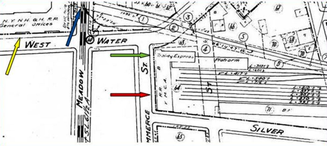
[4.11.3] The RR YMCA and the surrounding area is shown here on the 1915 valuation map, with the Silver St. yard behind it and before the changes of 1920. Click here for the entire map section. Our yellow arrow points to the GOB, the blue arrow to the trolley connection, the red arrow to the Commerce St. depot, now the RR YMCA, and the green arrow to the trolley express wing. The darker dashed lines are the Connecticut Co. tracks on Meadow St. with the old Derby main tied in, not having crossed the street since 1892 through the site where the GOB was built and where the original NH&D facilities had been located. See Track 6, MP 6.6 for the events of 1892. The 1878 Derby passenger station, now the south wing of the Commerce St. structure, once stood above the word 'Water' in West Water St.
Google Books
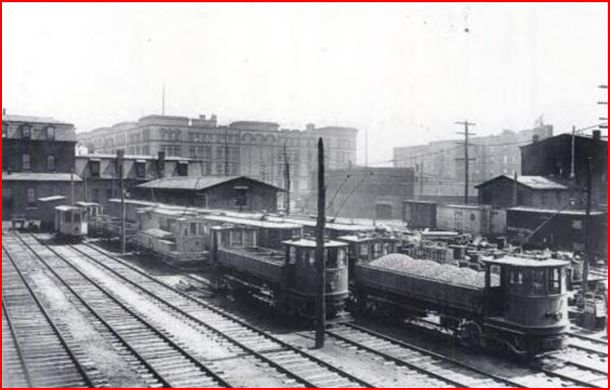
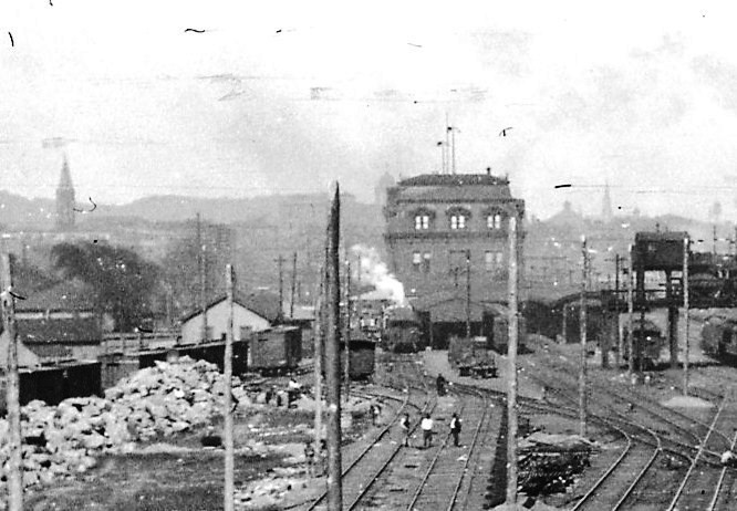
[4.12] This photograph appeared in a 1912 city-planning pamphlet called Railroad Station Approach and Harbor Front Improvements. Click here for full document from Google Books. The view looks out to the Silver St. yard from the upper level of the RR YMCA. Note the Conn. Co. trolley express cars on the left-most track, where they are lined up along the old NH&D freight platform. This crowded scene is probably not unlike the busy final days of the NH&D/HRR operation, twenty years earlier, when 50 passenger and freight trains were coming into the Derby terminal most weekdays.
Branford Electric Railway Association
|
Branford Electric Railway Association
|
[4.12.1] These photos appear in New Haven Streetcars [p.25], another of the wonderful Images of America series books put out by Arcadia Press. This was a Branford Electric Railway Association project. The Consolidated Railway Co., not to be confused with the NYNH&H itself, was created in 1904 as its streetcar holding company. By 1907 it was reorganized as the Connecticut Co. with the old Trolley Express Co. renamed as the Conn. Co. Express Dept. This system served 57 freight stations around the state. Seen here are rear views of the headquarters at the 1878 NH&D station and the Silver Street yard. The left photo shows the GOB towering in the background, with boxcars to the right on the old NH&D main. The second photo shows the street side with merchandise arrayed on the platform and horse-drawn wagons being loaded. These shots are prior to the roll-back of the YMCA in 1920 and possibly go back to 1905 for the upper, and 1907 for the lower photo, based on the Conn. Co. logo seen on the cars.
[4.13] This is an eastward-looking view of the rear of the RR YMCA with the Silver St. yard behind it. The negative has been corrected from the reversed printing in our original NH&D history published in 1981 [SL12.4.13]. There is a glimpse of the GOB across the street around the north end of the structure. The single story extension on the back, possibly the train-access area for passengers in the NH&D/HRR era, was converted into the YMCA's bowling alley. The Connecticut Co. car parallel to the rear of the building dates the shot to ca. 1920 or later, after the structure was moved backward. See MP 4.14 below and Track 6, MP 6.8.

Robert Lingane Collection
|
|
[4.14] The aerial map shot shows the new alignment of Commerce St. as the approach to the 1920 station, which is just out of view in the lower right. It also shows how the old NH&D freight wing has been moved west to make room for the backward shifting of the YMCA. The space left in between was cleverly used to run a track along the back of the YMCA curving around with ladder tracks to reach Silver St. and Freight House C. The trolley express operation was relocated to these quarters possibly as early as 1914 before the street changes. The old NH&D freight house wing and platform were subsequently used for warehousing produce. The val photo at left, dated 4/15/1927, shows the space between the two-story 1878 portion of the YMCA and the freight house with the 'Produce' sign to the left.

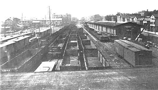
[4.15] A 1/31/1933 view of the east end of Freight House C in the Silver St. yard. Notice how the yard tracks have been dead-ended farther west and the ladder tracks come around the back of the YMCA and fan out to the freight house.
[4.16] A 1925 view of the west end of Freight House C in the Silver St. yard. Note the end-door opening on the Conn. Co. trolley express car to facilitate freight loading.
[4.16.1] This photo captured the demolition of the RR YMCA, probably shortly after it closed on April 30, 1966. The view looks north from West Water St. The Silver St. freight yard went at the same time. The 1966 Register article that appeared the day after the YMCA closed was entitled "End of the Line for Railroad 'Y'" and subtitled "Doomed by Revelopment." [NHR/05/01/1966/S4/01]

ICC Collection/ National Archives
|
ICC Collection/ National Archives
|
|
|
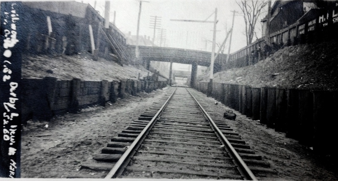
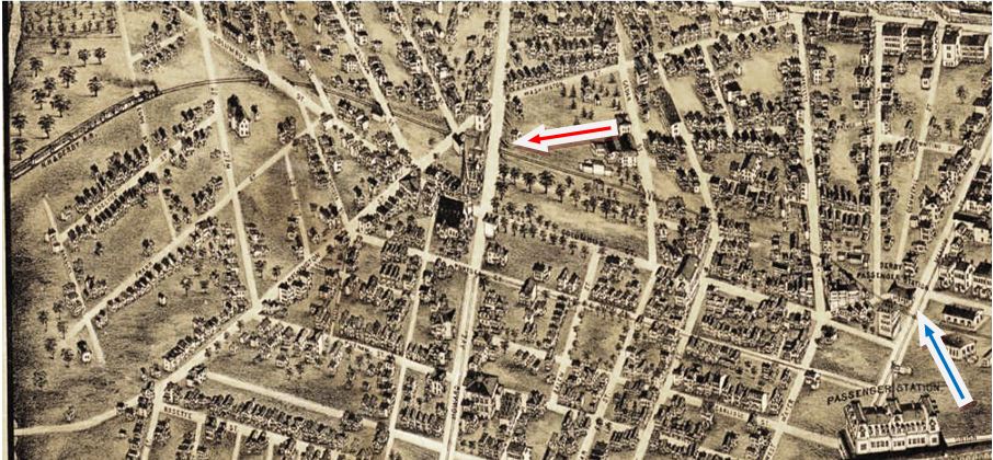
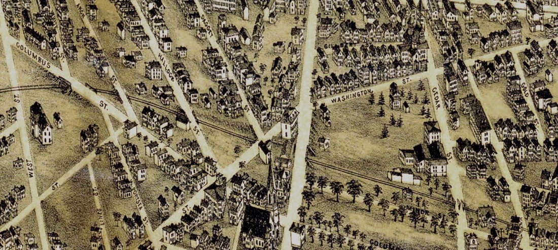
[4.16.2] These 1917 val photos show the Derby line bridges about a half mile west of the GOB, which was mile post 0+0 for the Berkshire Division when it was established in 1892. The NH&D track was then severed at Meadow St. as part of the changes when the NYNH&H took over the HRR and its leased lines. While passenger trains thereafter used the West River Connector to get into Union Station, the NH&D line from the West River was used to access the busy Silver St. yard. At what appear to be MP .52 and .65, the photographer is in the vicinity of Howard Ave., which is approximately a half mile west of the GOB. The bridges undoubtedly date back to the 1870s and 1880s when they were constructed by the NH&D. The retaining walls in the val photos were likely reinforced later by the NYNH&H. The lower images are from the 1879 Bailey bird's-eye map of New Haven. The shot at left shows the NH&D 1878 depot at the blue arrow and the Howard Ave. overpass at the red arrow. The zoom shot at lower right shows the Cedar, Howard, Washington/Daggett, Arch, Hallock, and Columbus street bridges over the railroad tracks. [add120512]
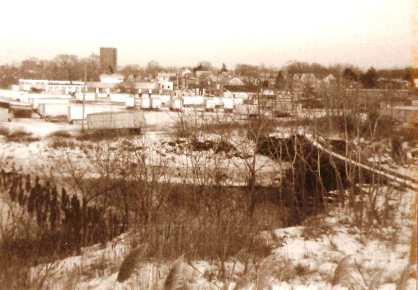
[4.16.3] This is a street-level shot of the Howard Ave. bridge over the NH&D ROW, looking east toward the Cedar St. and Liberty St. bridges and the Silver St. yard. The yard and the old NH&D station were not all that long gone when we took this shot in the late 1970s. It looks like chain-link fence has already replaced the older railings between the buldings. A few years later, when Conrail would not clean up the trash in the cut below these bridges, the city bought the right of way from the Boulevard to Cedar St. for $5,000, and filled and capped most of it at a cost of $300,000. Lee H.S. and public housing were built on some of the resulting land [NHR/09/27/1980/??; NHR/01/23/1981/??].
|

|
|
William N. Quinn Collection
|

|
|
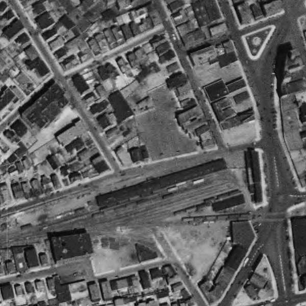
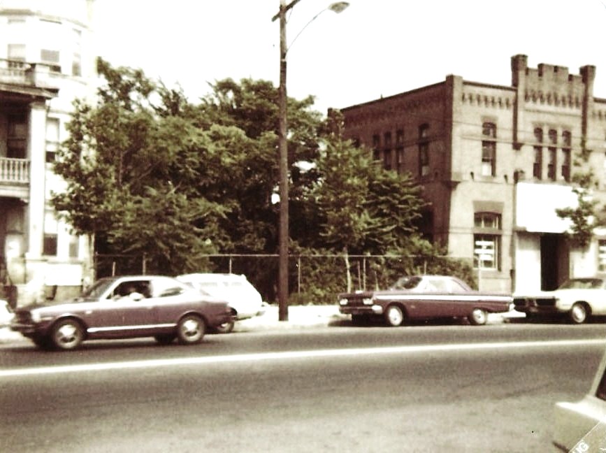
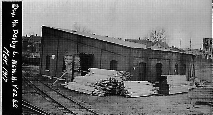
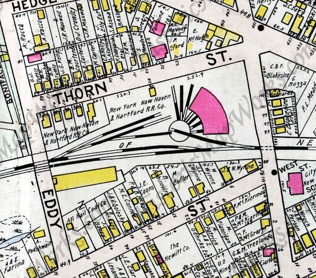
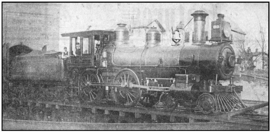
[4.17] Pursuant to the stipulation in the sale agreement that the NH&D confine its operations to the west of Meadow St. and with the increase in business that followed the HRR lease, the NH&D built a roundhouse at Thorn and West Sts. in New Haven. Work was reported to have begun late in 1889 when the Derby road asked the city to remove drains on the property so they would not interfere with the construction. The facility was put up as a four-stall structure, as evidenced by the 1911 map at middle left. By the June, 1915 val map at lower middle, it has become a six-stall facility. Though we have not yet seen mention of this renovation in newspaper accounts or company records, the March, 1917 front and back val photos in the top row bear this out. The image at left shows the rear view from West St., the facade that was kept as the front of the subsequent structure: see below. The shot at lower left shows engineer Thomas Quinn on the turntable in HRR No. 33. The number is seen on the side of the headlamp. The engine appears to have just emerged from the last stall, the south corner of the roundhouse visible behind the tender. The fireman is Harry Merwin in the photo that likely dates to between early 1890 when this roundhouse opened and 1892 when the HRR was leased by the NYNH&H. The same image appears in Lines West, with the engine mislabeled as No. 39 in the caption. At lower right is the 1934 aerial map view of the roundhouse site. The level, rectangular plots seen above the track on the left are the eastern portion of St. Bernard's Cemetery.
Courtesy of Mary A. Hoyt
|

Courtesy of Mary A. Hoyt
|

Courtesy of Mary A. Hoyt
|
[4.18] These unique and rare artifacts are a treasure trove of information about NH&D/HRR operations in 1890! They are the prized possessions of Mary A. Hoyt, granddaughter of Harry Merwin, the fireman who is pictured in the cab in the photo at lower left in the previous entry. Assuming the conductor's report correlates with that photo, this is the same No. 33 locomotive seen in our previous entry and engineer Tom Quinn is standing to Merwin's left. The hats and their features do appear to be a match for both of them. On the ground are the remaining four crew members: H. S. Beers, conductor, whose name appears appropriately ahead of the others on page 1 of the report and who is probably seen on the right; J. Hovey, baggageman, probably with the white outfit; and M. Quinn and W. Marshall, brakemen, with their matching uniforms, on either side of Hovey. Of these men, only Herbert S. Beers is familiar to us, pictured also on Track 5, MP 5.17.1 though seemingly bearded there. Interior pages 2 and 3 show that this crew and this engine will be operating six trains in the course of Thursday, June 26, 1890. It is exciting to think that this assortment of passenger, baggage, smokers, and one combination car listed on page 4 are a 10-car consist that will travel back and forth all day and. With 50 trains per day coming into New Haven by this time, this larger consist may have been an exception to the three-car locals often pictured on the Derby line. Note that some of the cars are NH&D, some HRR, and there is a single NYNH&H passenger car, no. 396, being handed over at Derby (Jct.) from its Naugatuck Division for delivery to New Haven. The interior pages of the report show the train roster and activity for the day, alternating through the three westbound trains on the left and the three eastbound trains on the right. Train 5 is the crew's first run of the day, leaving New Haven at 8:10 a.m. and arriving in Ansonia at 8:40, making all stops. The consist leaves as train 20 at 9:08, arriving back in New Haven at 9:38. Next out it is train 15 leaving at 10:00 and arriving at 10:26 in Ansonia, turning around as train 24 at 11:42, making all stops and arriving in New Haven at 12:15 p.m. With probably a break for lunch, the crew leaves New Haven as train 23 at 1:43 making stops at Derby (Jct.), Shelton and Stevenson, arriving at Botsford at 3:50, returning at 4:57 as train 18 and arriving back in New Haven at 5:53. It is worth noting that this is an all-passenger train, which the NH&D began running in the Housatonic era, and the figures at the bottom of each column may be the numbers of passengers carried, train 23 being empty and train 15 perhaps carrying 2 children represented by the small underlined numeral. Conductor Beers notes that train 18 was delayed, perhaps meaning by engine No. 18 at Botsford, on the main line from Bridgeport. Many thanks to Mary Hoyt for her permission to showcase these priceless materials on TCS. The data here is also entered on Track 3, MP 3.6.2 where we have rosters of personnel and equipment.
|
|

|
|
|
|
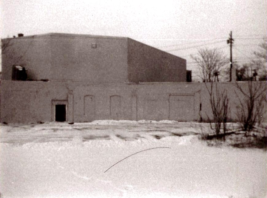
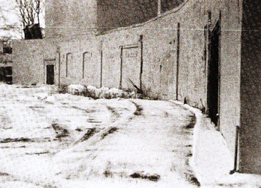
[4.19] The first four photos were taken in the 1980s and the last two in 2012 on a recent visit to PJ's Construction Co., the current tenant in this commercial structure. While we had previously thought that the entire roundhouse had been preserved, only the rear wall was retained as the front of a newer building and it has been masked by a more recent addition ahead of that also. The top shots show the front of the building as it used to look and the middle shots show the West St. overpass. That flimsy structure looks more like an 1871 NH&D bridge than something in 1980. The lower left shot looks toward the filled-in bridge where the ROW once continued east. In the interior shot at lower right, a bricked-in window in the concave 1890 rear wall, that is now within the present structure, can be seen.

C. Dunn Collection
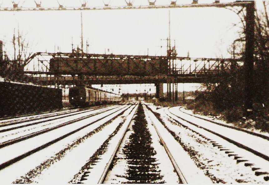
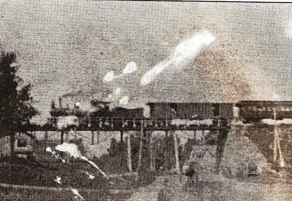
[4.20] This is most likely an eastbound train on the NH&D's 1871 West River trestle heading into New Haven, at a pretty good clip judging by the snow being kicked up! If the direction of travel is correct, this picture predates the NYNH&H's 1892 West River branch [NHER/10/27/1892/03] that would curve to the south (engineer's right), just about where the train is, cross to the river's east side and thence along it and into Union Station. Closer scrutiny of the engine might give us a better idea, but this looks like the Housatonic era, 1888-1892, with the train headed for the new NH&D station on Commerce St.
[4.21] In the foreground are the pilings for the trestle that the train is on in the shot above. This was abandoned on January 15, 1938, along with the line from just west of here to Orange center. The trestle still standing was the NYNH&H's 1892 connector to Union Station. Track to reach the rendering company that was located just west of the river was left in place possibly as late as the 1970s, but was presumed gone when this picture was taken in 1978. On September 26, 2001, the trestle seen here, which had collapsed into the river at some point later, was removed through the activist efforts of New Haven mayoral candidate Joel Schiavone.
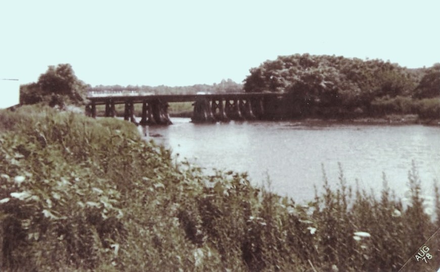
|
|
[4.21.1] Two more views of the West River crossing from the early 1980s. The one on the left looks south, with high tide covering the pilings for the 1871 NH&D trestle. We must have been standing on the bluff to the west to take the right 'aerial' shot which looks back toward downtown New Haven. The pilings are visible in the river as is the 1892 trestle curving south to go to Union Station. In the far distance, the 1969 Knights of Columbus tower can be seen on the left and to its right is the NYNH&H's 1947 headquarters building.
The West River Branch
This detour will briefly take us off the NH&D main and back to the Meadow Street Union Station via the 1.66-mile connector that the NYNH&H put into use late in 1892.
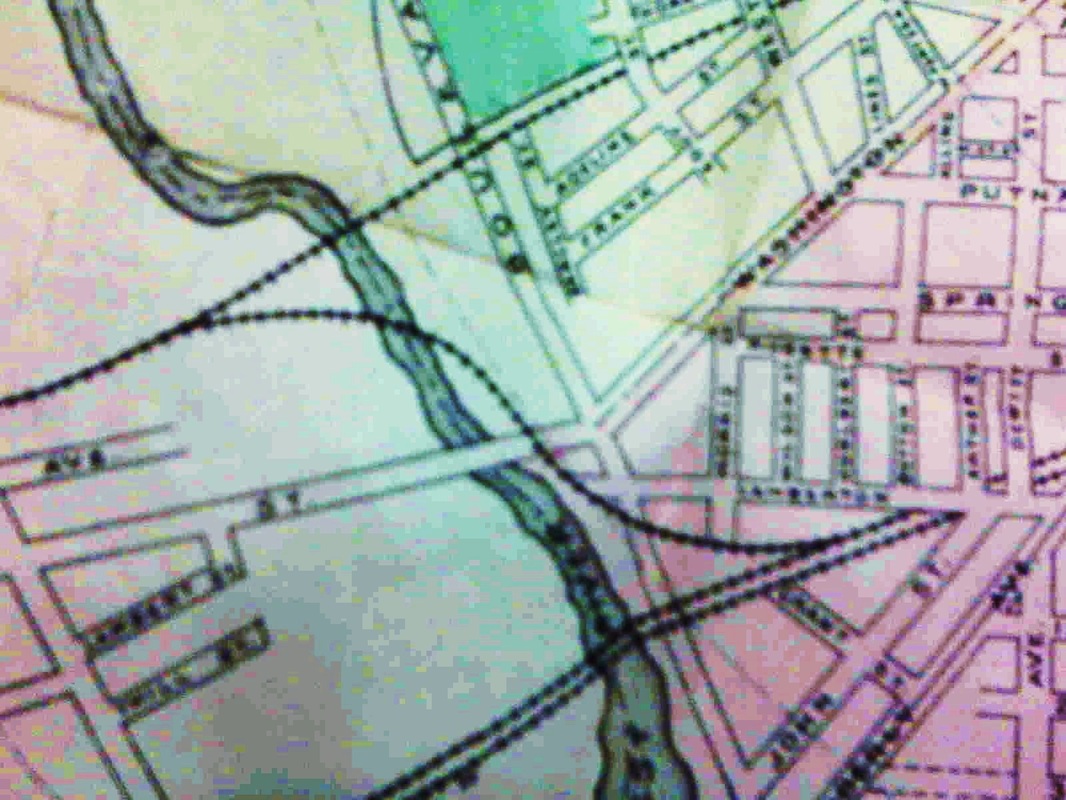
[4.22] The 1892 New Haven city directory map shows the West River Branch connector installed by the Consolidated late that year to bring trains from the newly inaugurated Berkshire Division into Union Station. The Derby line track to the east was cut back to Meadow St. at the same time. The east leg of the wye was added here soon after to give better access to the Derby terminal yards along Silver St.
Max Miller Collection
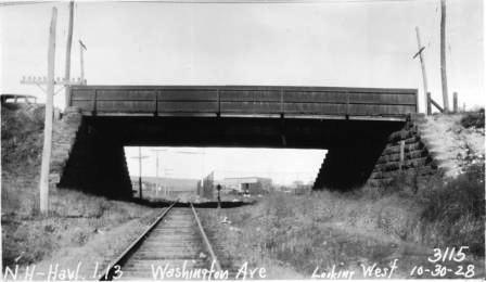
[4.22.1] This shot shows the Washington Ave. bridge in New Haven, a point located in the middle of the map above. The bridge was ordered by the railroad commissioners in 1892 [RRC31.493+] when the West River Branch was opened, though we think it was not built immediately. These photos were taken with the annual inspections the PUC performed as they took over the duties of the old Board of Railroad Commissioners in 1911. By the 1920s, these tours included the taking of pictures in all four directions at each public railroad crossing and examining all the bridges for structural condition and height. Some pictures show the commissioners using a 'story stick' to measure the clearance to make sure it conformed with commission specifications. The photos were pasted into notebooks that were later discarded and ultimately came into the hands of Max Miller, to whom we owe an inestimable debt of thanks for recognizing their significance and preserving them. The notebooks also contain crossing diagrams and bridge information that was updated when changes were made by the railroad, often per order of the commissioners to address safety concerns.

[4.22.2] This photo, though murky, shows trains on the Derby tracks at the west end of the 1875 New Haven Union Station. This is sometime after the 1894 opening of the 'Yellow Building,' the new General Office Building, which is visible to the far left, and appears to be prior to the 1913 electrification that would put poles, later catenary towers, into the picture as seen in the next item.
Copyright NHRHTA
|
Copyright NHRHTA
|
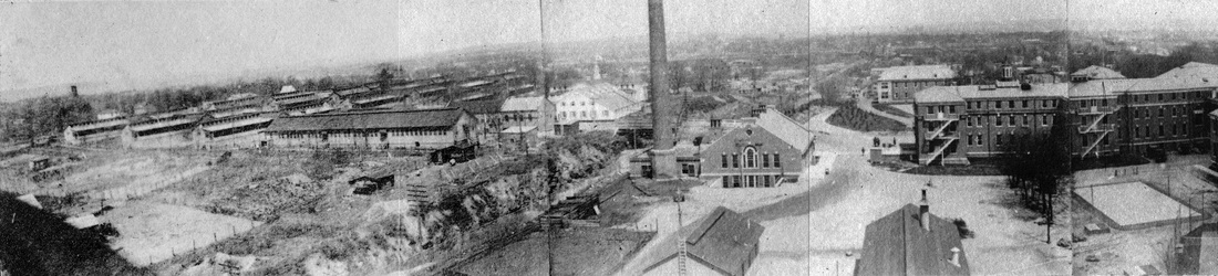
[4.23] In this panoramic photo of the west end of the Meadow St. station, the tip of the General Office Bldg., which opened on January 1, 1894, can be seen all the way over to the left, beneath the white semaphore signal blade. The wooden poles being put up in the photo's foreground are thought to be for wiring prior to the catenary towers that would complete the electrification of the New York Division. That would probably date this photograph to 1913. The photo on the right is a close-up, showing where the pocket tracks on either side of the platform were designated as the terminus for Derby locals and Berkshire line trains.
[4.24] This is the view going west out of Union Station toward the West River Branch, which is the right-most, fifth track in this 1978 shot. A New Haven-bound Metro-North train approaches on track 4. The bridge over the tracks was a pedestrian footbridge connecting Grant and Morris Sts.
Back on the NH&D Main Line...
[4.25] Resuming the Derby main at the West River going toward Ansonia, we cross into what was the town of Orange until its West Haven borough was made an independent township in 1921. Merwin's slaughterhouse was located just west of the river and Merwin's siding was the scene of a serious wreck in 1912.

[4.26] The arrow shows the location of the accident on this 1892 USGS topographic map. The map also reflects the completion of the wye with the east leg installed allowing trains to back from here into Union Station or vice versa to reverse direction. This was apparently easier than running the engines through the yard downtown and turning them there. The June 4, 1911 timetable lists 12 daily and eight Sunday trains each way, including the two daily Berkshire line trains each way between Pittsfield and New Haven.
William N. Quinn Collection
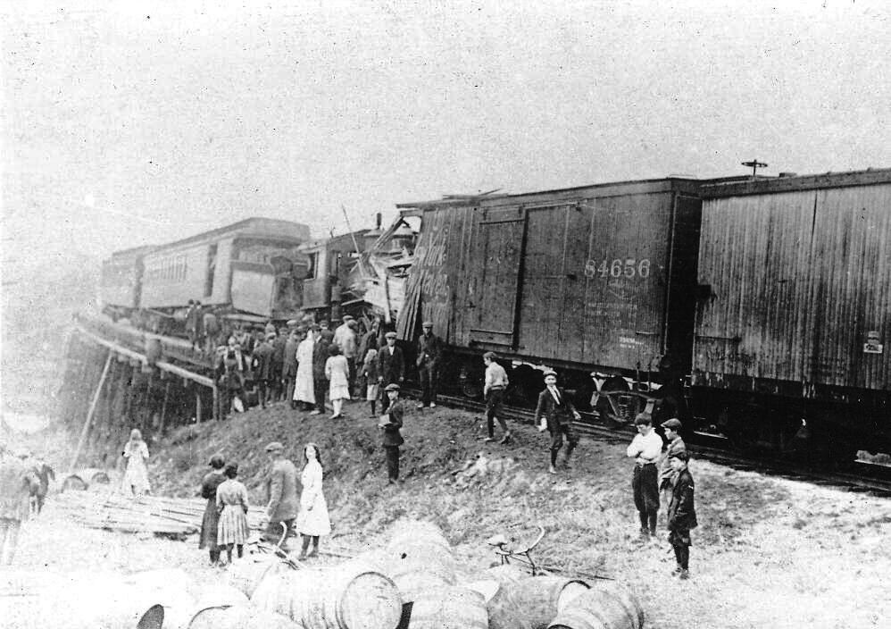
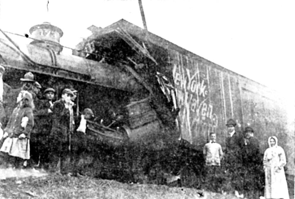
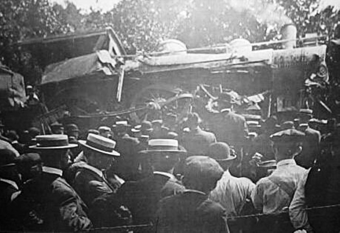
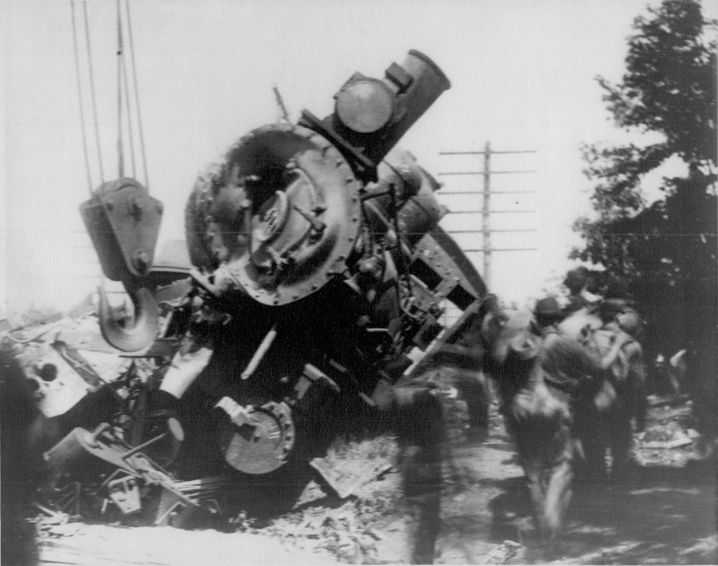
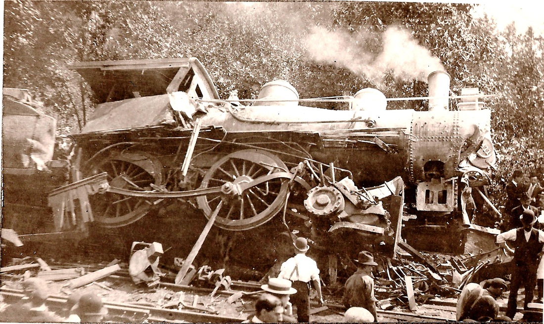
[4.27] Engineer Thomas Quinn, whom we have already met, was in the cab when a string of boxcars was backed out of the siding onto the main in front of him. He is credited with saving the lives of his passengers by sticking to his brake lever in this accident on October 14, 1912. See NHRHTA Bulletin #11 (February, 2003), for a New Haven Register story by William J. Prendergast about Thomas Quinn through the eyes of his son, William N. Quinn, who supplied these photographs.
[4.28] The caption for this picture in Lines West says that a string of boxcars was backed out onto the main in front of the morning local from Derby to New Haven. On closer inspection, it appears that the 1731 is coming off the West River trestle, which would make this the morning local to Derby, not to New Haven. Looking at the valuation map below, the only way the 1731 could have hit the rear of the box-car string in this manner is if the 1731 was going toward Derby.

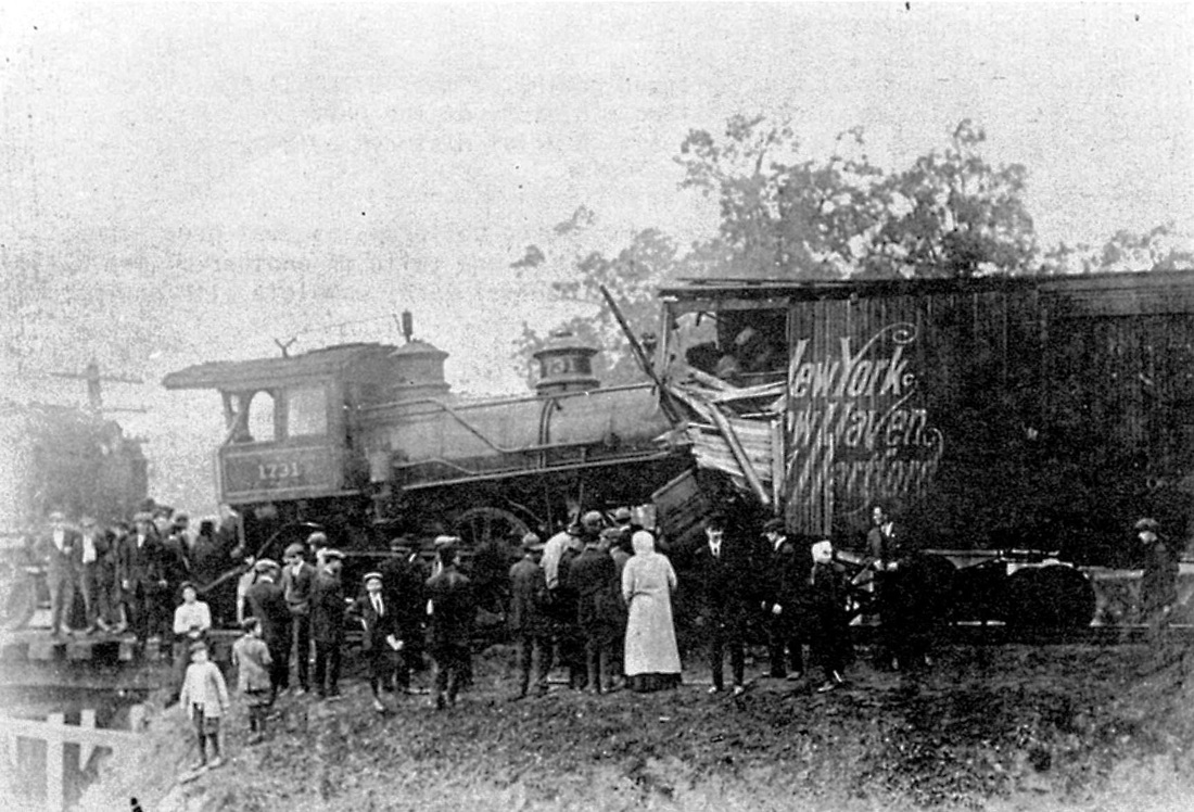
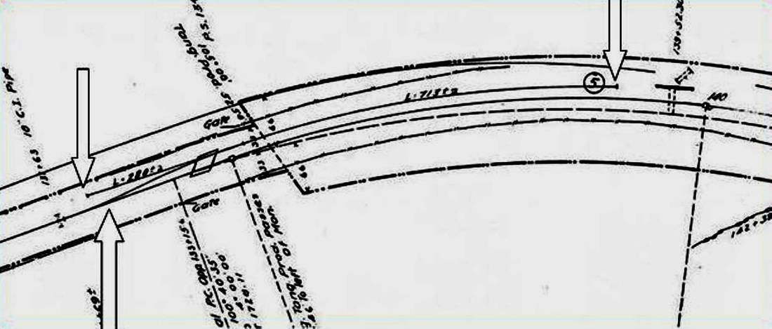
[4.29] The right arrow on the 1915 valuation map is the siding switch where the boxcars were backed out. Click here for the entire map section. The Merwin's plant, south of the Derby main, appears to have evolved into the New Haven Rendering Co. by 1915, if that was not its official name all along. The left arrow is at the point of impact at the river trestle as shown in the first picture. The fact that the long trestle is straight behind the Derby local must mean that it was backed out to the West River wye to reverse direction and it proceeded forward across the river. The short distance to the point of impact argues for poor visibility that morning.
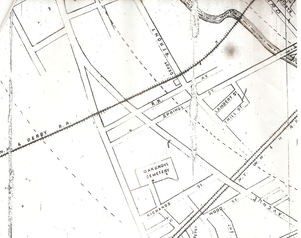
[4.30] This map is from the 1891 Price & Lee New Haven city directory. It shows the depot for West Haven, also known as Allingtown, at the northwest corner of Front and Railroad Aves. The line was elevated at this point and the station was presumably at street level. No photos of this station have been identified. The NYNH&H shows as double track on lower part of map. By the middle of 1892, the NH&D track would also be labeled as NYNH&H and would belong to the Consolidated with its takeover of the Housatonic RR and its leased lines.

 New Haven Register
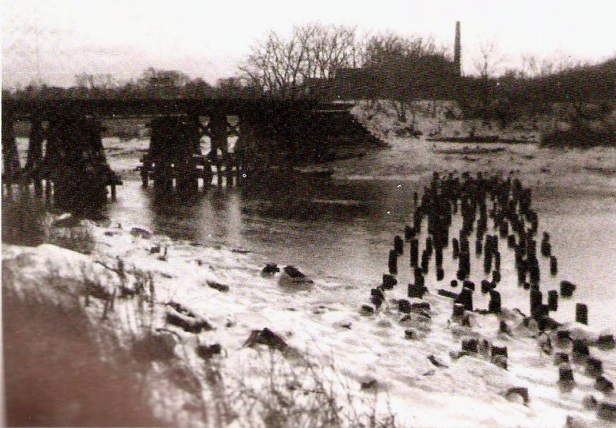
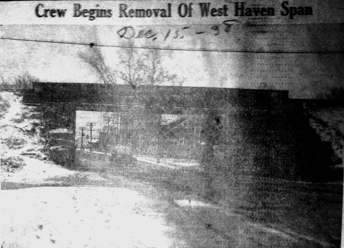
[4.30.1] We found this Register photo clipping in a scrapbook at the Orange Historical Society. The portion of the Derby line from the West River to Orange center was abandoned effective 6/13/1938 and this shows that the salvage operation was begun by the end of the year. This poor newspaper image is the only shot we have ever seen of any bridge over First Ave., this being a standard NYNH&H steel bridge probably put in with the 1909 upgrade of this busy line. Obviously we would like to have not only a better shot of this, but any of the earlier bridges that the NH&D put up. We can probably assume from this that not only were the rails taken up at this time, but also the embankment that filled in the original trestle work was removed from here to Campbell Ave. leaving the great concrete bridge there 'marooned' until it came down on 8/6/1953. See below at MP 4.35. [rev012616]
[4.31] This shot corresponds to the view on the map above. It shows the crossings of both First Ave. on the right and Campbell Ave. on the left. The filling of the old trestlework under the line was probably done prior to the 1892 lease and, if not, was finished thereafter by the Consolidated along with the improvements of 1909 (see below). That work most likely took out whatever remained of the station at Front Ave. where no signs are seen by this time. Passenger service on the line ended in 1925. The northeast corner of the VA hospital property is seen on the lower left.
West Haven Historical Society
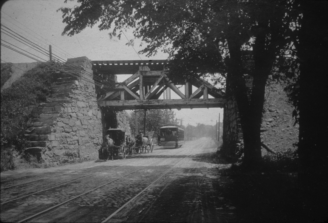
[4.32] An early NHD&A engine crossing what was then variously called Fourth Ave, Allingtown Rd., or West Haven Road. By 1874, the thoroughfare would be known officially as Campbell Ave. to honor the British army adjutant who saved the life of a West Haven minister only to be shot later himself during the British invasion of West Haven in 1779. Note the primitive early construction on opening in 1871 with the rough-hewn stone abutment and spindly wooden trestle. One can't be completely sure but this train is probably heading to New Haven having just come through the Allingtown cut and onto trestlework that extended almost all the way to the West River. The bridge would be upgraded later and the trestlework filled in.
[4.32.1] This is the later bridge over West Haven Rd., now Campbell Ave. There are solid stone abutments on both sides of the road, a sturdy wooden truss bridge, and filled embankments replacing the trestle work. Comparing the electrical wires in the shot below, the buggies and the trolley are likely heading south, making this a view to the north. This bridge may have been built in 1875-1876 when the NH&D spent nearly $24,000 for infrastructure improvements including bridges [CRC 23.1876.208]. New abutments, "at the Allingtown highway bridge," likely the ones seen here, were put up in 1881 [CRC29.1882.34]. The overhead trolley wire indicates that this scene is after the New Haven and West Haven Horse RR went electric in July of 1892 [NHER/07/07/1892/01], about the same time as the double-tracking [NHER/11/25/1892/04], so this shot has to be between then and the 1909 bridge replacement by the NYNH&H. A spokesman at the Shore Line Trolley Museum [click here] says the streetcar looks like a ca. 1901 Brill, 12-bench, two-truck, open car similar to the museum's 15-bench #614. A clearer look at the signboard on the car might narrow the 1901-1909 time frame somewhat further.
Morgan Dunnigan Collection
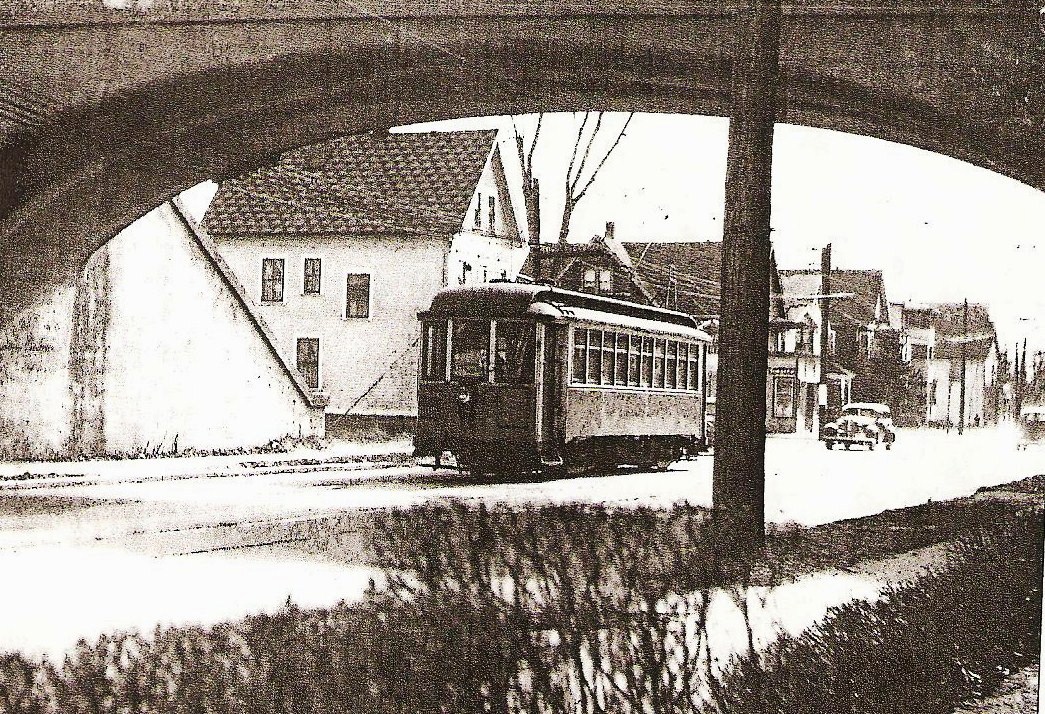
[4.32.2] Many thanks to Ellen and the gang at Marshall's Garage for contacting Morgan Dunnigan so we could have this historic photo. Work is being completed on the impressive concrete bridge in September of 1909. The older truss bridge has been removed and, if you look closely under the arch, you can see the temporary fly-around bridge standing on wooden pilings just behind it. Note also the 'Slow' sign above what is probably the roofline of a construction car on the new bridge and the busy workers on the flat car to the right. The view looks north up a still-primitive Campbell Ave. that carries the double-tracked trolley line, operated since June 1, 1907 by the Connecticut Co. These upgrades to the busy Derby line came at a time when there were still a dozen or so daily passenger trains each way, including two to Pittsfield on the Berkshire Division. Additionally, NYNH&H Symbol Book No. 4, in effect June 5, 1910, shows a single weekday, way freight leaving New Haven at 9:15 p.m., arriving at Derby about 10.00 p.m., leaving Derby at about 10.15 p.m. and arriving back at New Haven about 10.45 p.m. Thanks to Richard Fleischer for the freight traffic info.

C. Dunn Collection
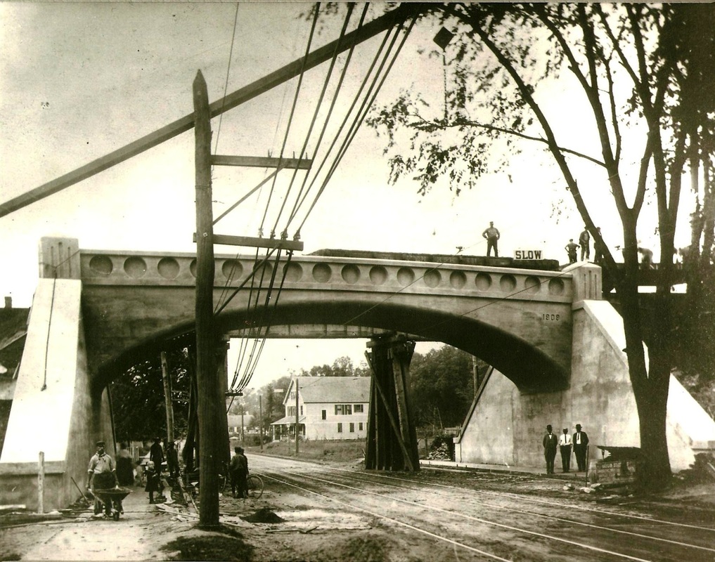
[4.33] The Art Deco pattern in this beautiful structure is akin in design to the Merritt Parkway bridges created by George Dunkelberger [click here] and the bridge was apparently photogenic enough to make it onto a postcard. The immaculate appearance here makes it look like this was was taken just after completion around October 1, 1909. There is nothing to indicate that this structure was designed anywhere other than in the railroad's engineering department. This view looks north. Interestingly, we have learned that it was the borough of West Haven that had initiated the request for a new bridge so that the road could be widened and sidewalks put in. The other reason for the "fine looking concrete span over Campbell Ave," was that a longer distance could be covered with the arch and without the need for central support columns in the middle of the street. The borough also may have desired that this bridge be an ornamental gateway to the downtown and was happily served by a structure that was both utilitarian and beautiful. Thus, it was so ordered by the railroad commissioners who apportioned the cost equally between the railroad, the Connecticut Co. for the trolley line passing beneath, and the borough. Each share was $6,700, apparently agreeable to all parties. An attempt to spread the borough's cost over the entire town of Orange, of which West Haven was still a part, was expected to be roundly defeated at a town meeting. We have not found yet the upshot of that effort. The Register reported that the clearance height for the trolley cars was 21 feet, "considerably greater than the old span" and the width of the span was 61 feet. Cement sidewalks and high gutters were also part of the project to prevent water from collecting at what was called "one of the worst spots in Campbell avenue during a storm." [rev011516]
John K. Koella Photo
[4.34] This is a view looking south with Connecticut Co. streetcar #861 approaching on Sunday, February 2, 1947, about a year before trolley service ended in Connecticut, with the New Haven area the last bastion. The house with the four windows still stands in 2015 on the east side of Campbell Ave. across from Marshall's Garage. This photo appears in New Haven Streetcars [p45]. Our thanks to BERA and to Mr. Koella for permission to use this photograph.
Copyright NHRHTA, Inc
|
|
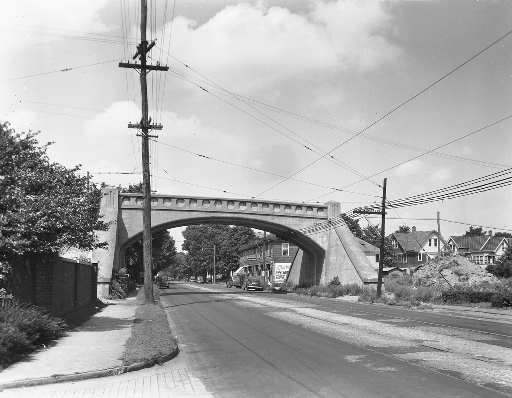
[4.35] After the Derby line was abandoned from West Haven to Orange in 1938, the track was pulled up and the embankments were removed, leaving the bridge still standing. It was probably left to avoid the cost of demolition, but it also still served to carry Maybrook dispatcher wires over Campbell Ave. The image on the left [add012616], probably from the 1940s, looks north to show the beautiful structure as a bridge to nowhere. On the east side of the street, there is a pile of earth that might possibly have been left over from the removal of the embankment fill. On the west side of the street one can see the driveway to the VA hospital in the foreground as well as the brick wall bordering its property. The wall would have to be cut back to the south and the telephone pole moved for to construct a driveway into Marshall's Garage when it opened at 990 Campbell Ave. The shot at right is from a 1955 Chamber of Commerce booklet; it clearly shows the marooned bridge [red arrow] as well as the original garage [blue arrow] building that the Curb Reporter for the West Haven Town Crier says was up in April, 1953. The new auto facility sat behind the big "white bridge" that was now deemed a traffic hazard for customers accessing the business. The garage, incidentally had to relocate here from 838 Campbell Ave. because of the coming construction of the Connecticut Turnpike. [REFS: WHTC/04/02/1953/16; WHTC/04/23/1953/13][rev012516]
Marshall's Garage
|

West Haven Historical Society
|

|
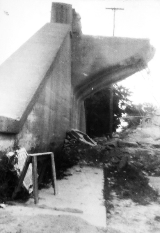
[4.35.1] The photos at [1] and [2] both show the west abutment in the course of the demolition; the first looks south. It sat, according to Marshall (Jr.) himself, smack dab in the middle of the photo [add012616] at [3] that now shows the newer front building on the property; the NH&D once passed right overhead! By summer, 1953, West Haven's "big brass" had decided that the bridge should come down because of "several near crashes." involving garage customers. Campbell Ave. was then blocked off from First Ave. to Spring St. for the work that was paid for by Marshall's. The newspaper said that a "power shovel, equipped with a two-ton ball" began to batter the center of the doomed bridge at 9:00 am on July 28, 1953, with the project supervised by Caesar Canestri, head of the Eastern Construction Co. Information relayed from Mr. Canestri indicates that the work was done, not with a wrecking ball, but with jackhammers and controlled blasting under the supervision of an expert from the dynamite company. A power shovel cleaned up the debris which fell onto the sand that had been spread below to protect the street. The old gas-powered shovel looked like the one Mike Mulligan used in the popular 1939 children's story. The work was completed in early August, the Curb Reporter noting the many people were snapping pictures sure to become "valuable momentos." Other than the ones here, none have turned up and no coverage at all of this notable event has been found in the Register. Someone out there has to have some! An interesting offshoot of the bridge demolition was the sponsoring by Marshall (Sr.) of a race car Mr. Canestri saw at the garage and its driver, Frank Belbusti, whom we once interviewed in Woodbridge. Those were the glory days of the West Haven Speedway, which was located at the east corner of Rock St. and Savin Ave., along today's Captain Thomas Blvd. So the sad passing of the 'Great Concrete Bridge' was at least the start of a happy association for these men. Thanks to Dan Shine, historian for the First Congregational Church of West Haven, for this information and the contact with Mr. Belbusti. Dan's articles currently appear as the Historian's Corner in the West Haven Voice. [rev012516]
TCS Collection
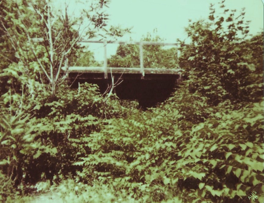
[4.35.2] This shot shows the 50-ft-deep Allingtown cut, just west of Campbell Ave, the scene of landslides, fallen boulders, and stalled NH&D engines on the westbound up-grade in the early days. After grueling lessons in photography, astronomy, and locomotive technology, we think it is virtually certain that the train is eastbound. When we flipped the negative horizontally, the knuckle on the coupler was, incorrectly, on the engineer's left. As seen here, the train could still be traveling west except that the sun in our northern hemisphere can only be in the southern sky, casting the locomotive's shadow perpendicularly to the north. Of course, in the words of the old 1930s radio show, only "The Shadow knows..." for sure! The pole line is probaby not as good a clue as we first thought. The photo at MP 4.47.1 shows pole lines on both sides of the NH&D track ca. 1900 and we know that SNET and AT&T lines ran on opposite sides of the NH&D: see Track 6, MP 6.5.1. The engine number seems to read 98. The widest date range of the shot is from 1900 to September of 1904, the former being the date when automatic couplers began to appear on locomotives and the latter when NYNH&H engines were renumbered, the #98 becoming the #1796. The cowcatcher on this locomotive has been replaced by a foot board, indicating it was a yard engine that may not have routinely pulled Derby line passenger trains. That makes this shot doubly interesting, unique, and historic.
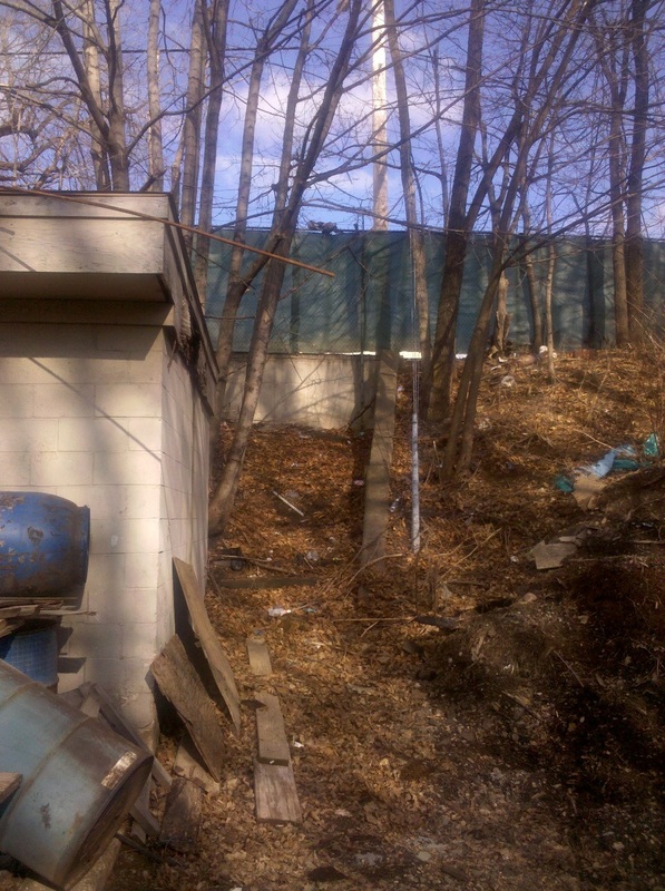
[4.35.3] With the embankments cut down to ground level, the land just west of the 'Great Concrete Bridge' on Campbell Ave. became the site of Marshall's Garage. The scene looked like this ca. 1980 and still does pretty much today. Beyond the parked trucks, the eastern end of the Allingtown cut is visible in the distance and the level of the ridge shows where the track once was. The right of way enters the VA hospital property at that point.
[4.36] The Derby line is running through the VA hospital property, just to the left (north) of the power plant smokestack. There is a bridge in the center over the track to facilitate access to the upper part of the property. The structures seen there are temporary wards built in 1919-1920 for soldiers returning from The Great War, WWI. This view looks east toward Campbell Ave. In the Derby road's early years, there was a tuberculosis sanitarium here and it is said that passengers would close the windows on the trains as they were coming through here for fear of contracting the illness.
[4.37] This shot shows the area just west of the VA hospital property in West Haven. The Allingtown siding is barely visible at this magnification. The switch was just east of the big curve. The siding was the scene of a famous wreck on September 15, 1907 involving engineer Phil Blakeslee, author of Lines West. [REFS: HC/09/16/1907/01; NHER/09/16,17/1907/01; SR/09/16/1907/09][rev032316].
C. Dunn Collection
|
C. Dunn Collection
|
|
[4.38] This is the #1411, Phil Blakeslee's engine, which was taking the Allingtown siding when struck by the down train from Ansonia that had failed to slow up for the meet. Engineer Johnson in the #1792 was killed; it is likely that he forgot about the Sunday-only train ahead of him and that brakes applied at the last minute were unable to stop his train. Blakeslee, though badly injured in in a 1905 wreck at NORTH KENT, was not seriously hurt this time and continued to work until 1947. He published Lines West in 1951. The best account of this accident [click here] is in The New York Times. The #1792 was scrapped immediately. The #1411 was rebuilt and served until it was retired in February, 1924. [REFS: NYT/09/16/1907/02; HC/03/31/1905/01][rev032316, new photo at [2]]
[4.39] This is the Allingtown siding from the valuation maps. Click here for entire map section. The entrance to this double-dead-ended siding was from the east at the upward-pointing arrow. Blakeslee's engine was taking the siding here when it was struck behind the boiler head. The downward-pointing arrows show the dead ends of the siding. Apparently, meets here required the train that took the siding from the east had to back out to take the main again.

[4.39.1] This New Haven-era concrete culvert stood behind the housing unit on the west side of Glade St. in 1980 and is probably still there today. The infamous curve is visible here, just beyond the hospital property and the Allingtown siding. The NH&D is turning north and heading for the Boston Post Rd, known as Milford Tpke. when the Derby road opened.
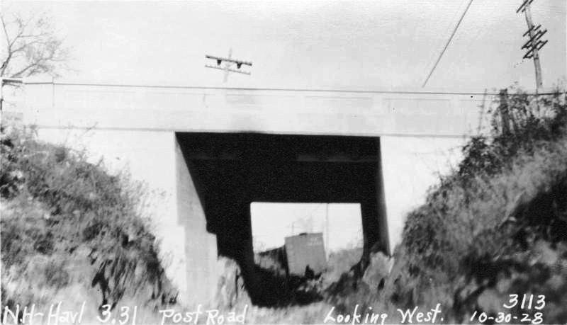
4.40] A perusal of PUC Docket 3554 and PUC Map 632 at the Connecticut State Library has explained a number of things about this mile point 3.31 bridge that carried Milford Tpke., today's Boston Post Rd., over the NH&D line. This was built probably in 1921 as shown by the 7/9/1920 construction plans with revisions on 1/3/1921. The plans called for "malleable iron posts" as the guard rails. Never quite sure whether this was a grade crossing previously, which would have been unlikely on the main road from Boston to New York, we now learn that there was an earlier wood plank bridge here that sat on "rubble masonary abutments." This earlier bridge likely dated back to 1871 or to NH&D improvements in the 1880s. Due to increased traffic by 1920, the highway department saw the need for an upgrade. The old abutments were strengthened with concrete walls and the planks were replaced by a concrete slab for the roadway which was raised slightly for a 16-ft track clearance. Our previous 1926 dating of this construction was based on a road-widening project in 1925-1926 - a temporary bridge mentioned in the Courant [HC/07/30/1926/06] may or may not have been in use here - and also on the the fact that we saw '1926' etched into the concrete side walls of the bridge as late as 1980. It is quite plausible that the side walls replaced the iron posts with the widening in 1926.
|

|
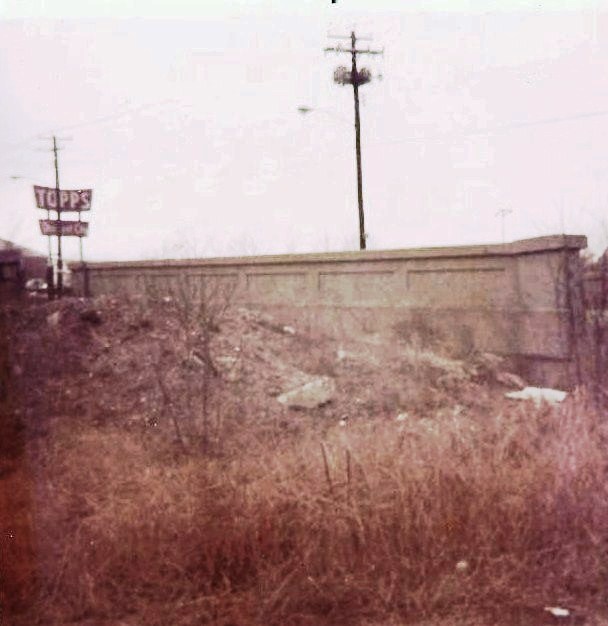
[4.40.1] This is the same view looking north, railroad west, ca. 1980. The box culvert is seen filled on this side. The bridge walls etched with '1926' have come down since the culvert ends have been capped and paved over. The sign for the Topps department store, which older residents will undoubtedly remember, is visible in the photo. That building, on the north side of the Post Rd., is still in commercial use today.
|
|
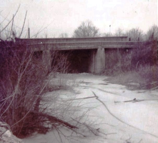
[4.40.2] Two more views of the Post Rd. culvert, but looking south, railroad east, both also taken in the late 1970s or early 1980s. It was also noticed recently that the northern portal of this bridge the looks much wider than that of the box culvert seen in the photo of the southern portal just above. It now seems likely that this was part of the 1925-1926 widening of the Post Rd. when freight service was still available on the Derby line. If this were not all buried now, it would be fascinating to walk under the old tunnel, something we regret not doing back in 1980, if it was even passable then.
Max Miller Collection
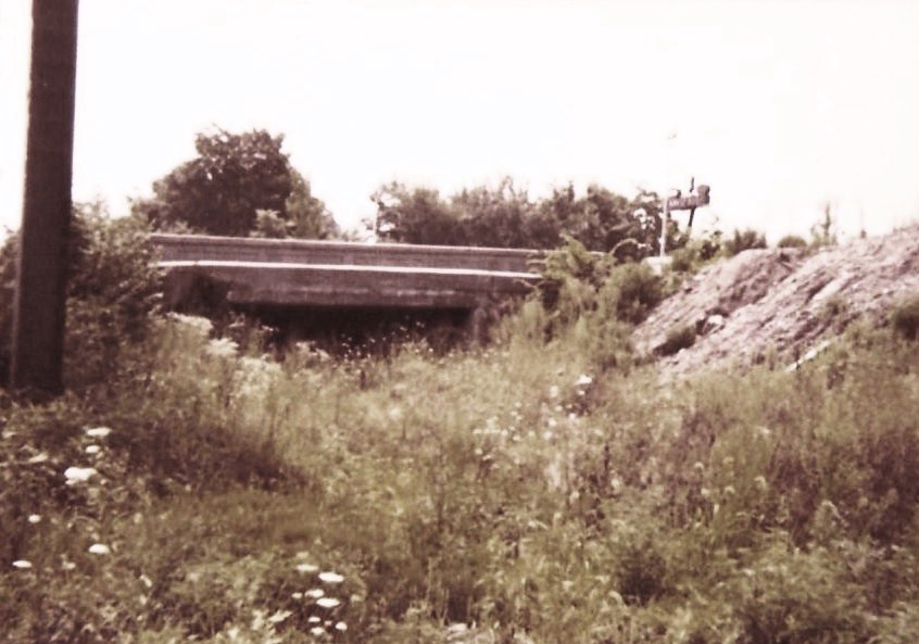
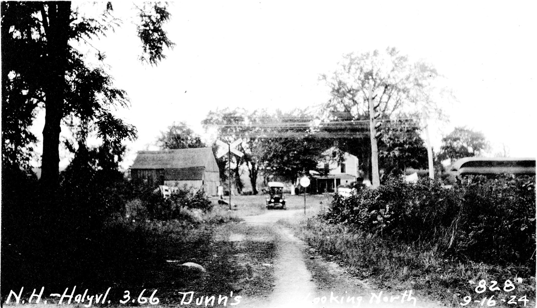
.40.3] Using the 3.31 mileage designation for the Post Rd. bridge, it would put Dunn's crossing at 3.66 above the Post Rd. Comparing this photo with the map below, the road even appears to bend to the right where the old automobile is sitting. This was the meeting point of Farwell St. and Fresh Meadow Rd., as seen on the map.
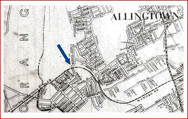
[4.40.4] This map from the 1925 Price and Lee New Haven city directory shows the area. Dunn's crossing is indicated by the blue arrow at the jog where Farwell St. and Fresh Meadow Rd. meet. Note the advisement on the far left saying that this railroad line goes to Derby, Danbury, Waterbury, and Winsted. Passenger service would end shortly. Additionally the crossing of the Post. Rd. is correctly indicated as passing under the road, an accuracy of detail not always seen on these maps.
Click here to continue on Track 4B...
Click here to continue on Track 4B...