Track 12: CT Passenger Stations, TI-V
See TCS Home Page links for information, abbreviations, and sources.
Use Track 11 map link to locate stations, rail and trolley lines, and POIs.
Use Track 11 map link to locate stations, rail and trolley lines, and POIs.
TIN BRIDGE [> MILL RIVER JUNCTION]
TOLLAND AND WILLINGTON [> WEST WILLINGTON]
TOLLAND AND WILLINGTON [> WEST WILLINGTON]
National Archives
|
|
|
|
|
|
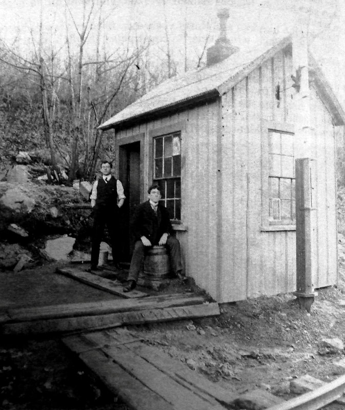
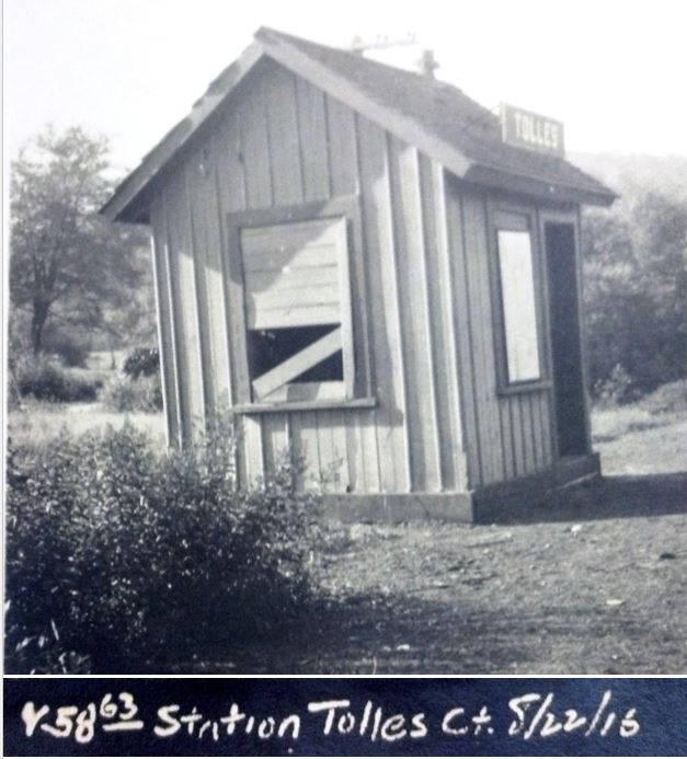
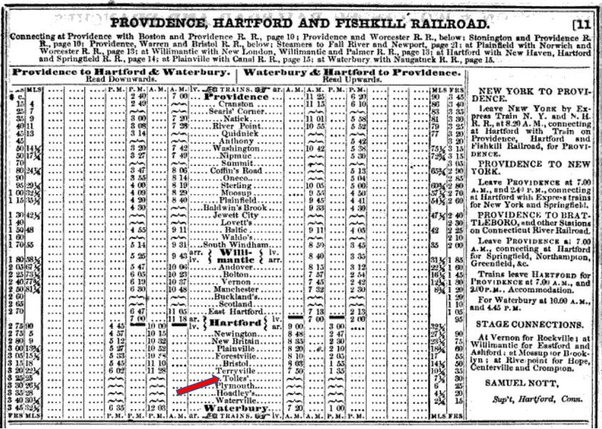
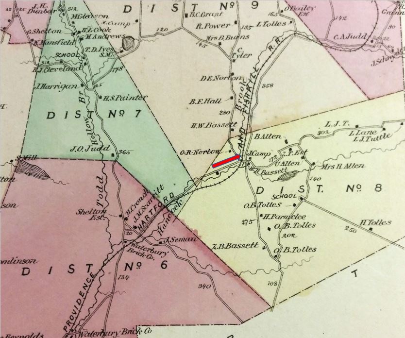
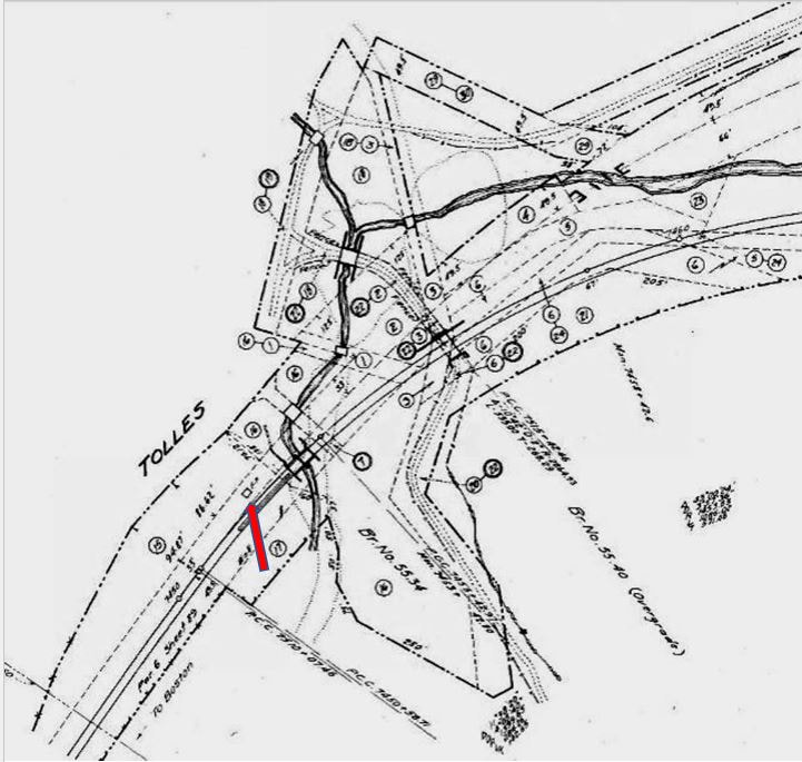
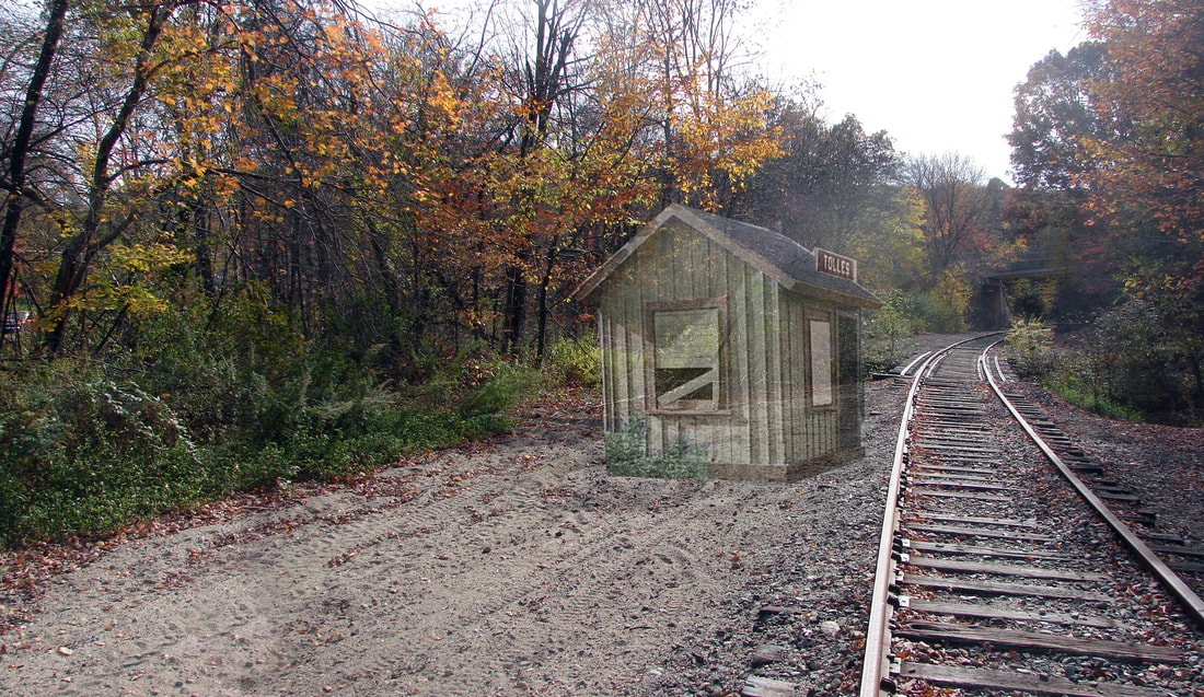
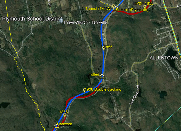
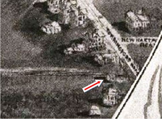
TOLLES [HP&F, 1855]
Assuming the pronunciation of this station name is as might be expected, it reminds us of For Whom the Bell Tolls, arguably Hemingway's greatest work. In railroad context, this stop in the southeasterly section of the town of Plymouth was most certainly established in 1855 when the HP&F extended its line from Bristol to Waterbury. It appears at least by 1858 in the Snow's Pathfinder Railway Guide timetable, seen at [2]. A horrific accident a quarter mile west of here on 5/10/1873 was caused by a broken rail and took the lives of Conductor George Bradley and, perhaps ironically, Section Master A. M. Butts who was responsible for track maintenance here. Also injured were several of the latter's men and a passenger, all of whom were in the freight train's caboose. The Waterbury Daily American editorial asked "Who is responsible for this?" and accused the railroad of causal negligence and skimping on inspections to increase stockholder dividends. The paper said even the ties were rotten! By 1878 the moribund HP&F was taken over by the NY&NE which was subsumed completely into the NYNH&H in 1898. Aside from this incident, there seems to be little to know about this minor station and photos are rare. We have doctored the 8/22/1916 valuation shot at [1] to better fit the presentation here. The 1874 map at [3], oddly enough, does not show the usual tick mark at the station site to which our red arrow points but it shows several Tolles family names nearby, apparently giving the station its designation in the custom of the day. Note that the timetable and the map misname the railroad as the PH&F, also seen elsewhere and likely a common misnomer for the HP&F. The tiny depot stood on the east side of the line as seen on the 6/30/1915 after the double-tracking of 1906-1910. This massive project straightened curves, eliminated grade crossings, leveled terrain, relocated highways and rechannelled waterways. The work culminated with the opening of the Terryville Tunnel on 1/28/1911. Just west (compass south) of the tunnel, the new line diverged at the exact point where the tiny TOLLES depot stood. The red arrow at right points to the overgrade highway bridge on the new alignment; a newer bridge spans today's South Eagle St. on the line that is in use in 2022 by Pan Am Southern. Al Weaver's south-looking ghost photo at [5] shows what the station would have looked like today in the still-extant clearing. The bridge just past the depot is for Hancock Brook which parallels the Highland Division on much of its route to Waterbury. The snippet at [6] is from our Track 11 Google Earth map and shows the station location today. The undated photo at [7] presumably shows the operator and a friend, prior to the improvements of 1910. Oddly, the depot looks to have originally been perpendicular to the track; the 1915 val map shows it parallel. Note also the flag stop pole in the foreground. The val photo at [1] showed the structure boarded up in 1916, perhaps indicating that it was no longer an agency station. Timetables in 1917 and 1923 still show TOLLES as a flag stop for weekday and Sunday trains but it is likely that the deep passenger-service cuts of 1925 doomed it. According to Karr, the last bell tolled for all passenger service from Hartford to Waterbury in 1959. Actually the last train ran on 1/22/1960. [REFS: PTT107 (2/1858), p11; WDA/05/10/1873/02,03; Form 220 TT (4/1/1917): yes; Form 220 TT (12/2/1923): yes; Form 200 TT (11/18/1928): no; HC/04/10/1939/01; HC/01/20/1960/04; HC/01/23/1960/6A; D134; K84, 85][rev041922, 042923]
Assuming the pronunciation of this station name is as might be expected, it reminds us of For Whom the Bell Tolls, arguably Hemingway's greatest work. In railroad context, this stop in the southeasterly section of the town of Plymouth was most certainly established in 1855 when the HP&F extended its line from Bristol to Waterbury. It appears at least by 1858 in the Snow's Pathfinder Railway Guide timetable, seen at [2]. A horrific accident a quarter mile west of here on 5/10/1873 was caused by a broken rail and took the lives of Conductor George Bradley and, perhaps ironically, Section Master A. M. Butts who was responsible for track maintenance here. Also injured were several of the latter's men and a passenger, all of whom were in the freight train's caboose. The Waterbury Daily American editorial asked "Who is responsible for this?" and accused the railroad of causal negligence and skimping on inspections to increase stockholder dividends. The paper said even the ties were rotten! By 1878 the moribund HP&F was taken over by the NY&NE which was subsumed completely into the NYNH&H in 1898. Aside from this incident, there seems to be little to know about this minor station and photos are rare. We have doctored the 8/22/1916 valuation shot at [1] to better fit the presentation here. The 1874 map at [3], oddly enough, does not show the usual tick mark at the station site to which our red arrow points but it shows several Tolles family names nearby, apparently giving the station its designation in the custom of the day. Note that the timetable and the map misname the railroad as the PH&F, also seen elsewhere and likely a common misnomer for the HP&F. The tiny depot stood on the east side of the line as seen on the 6/30/1915 after the double-tracking of 1906-1910. This massive project straightened curves, eliminated grade crossings, leveled terrain, relocated highways and rechannelled waterways. The work culminated with the opening of the Terryville Tunnel on 1/28/1911. Just west (compass south) of the tunnel, the new line diverged at the exact point where the tiny TOLLES depot stood. The red arrow at right points to the overgrade highway bridge on the new alignment; a newer bridge spans today's South Eagle St. on the line that is in use in 2022 by Pan Am Southern. Al Weaver's south-looking ghost photo at [5] shows what the station would have looked like today in the still-extant clearing. The bridge just past the depot is for Hancock Brook which parallels the Highland Division on much of its route to Waterbury. The snippet at [6] is from our Track 11 Google Earth map and shows the station location today. The undated photo at [7] presumably shows the operator and a friend, prior to the improvements of 1910. Oddly, the depot looks to have originally been perpendicular to the track; the 1915 val map shows it parallel. Note also the flag stop pole in the foreground. The val photo at [1] showed the structure boarded up in 1916, perhaps indicating that it was no longer an agency station. Timetables in 1917 and 1923 still show TOLLES as a flag stop for weekday and Sunday trains but it is likely that the deep passenger-service cuts of 1925 doomed it. According to Karr, the last bell tolled for all passenger service from Hartford to Waterbury in 1959. Actually the last train ran on 1/22/1960. [REFS: PTT107 (2/1858), p11; WDA/05/10/1873/02,03; Form 220 TT (4/1/1917): yes; Form 220 TT (12/2/1923): yes; Form 200 TT (11/18/1928): no; HC/04/10/1939/01; HC/01/20/1960/04; HC/01/23/1960/6A; D134; K84, 85][rev041922, 042923]
TOPSTONE [> SANFORD]
|

|

|
|
|
|

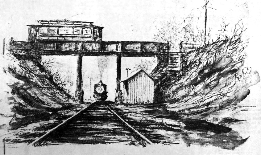
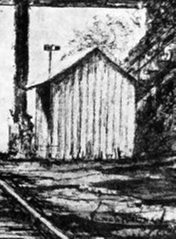
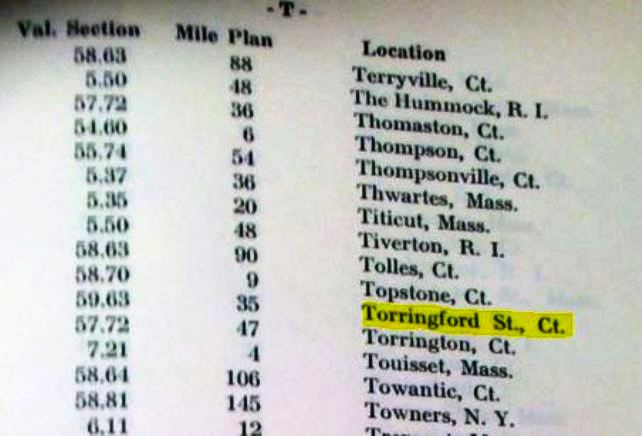
TORRINGFORD STREET [CNE, c1903]
The exact origins of this station in the town of Winchester are unclear. The rationale seems to have been to allow riders to switch between CNE trains and the trolleys of the Torrington & Winchester Street Rwy, which began operating on 6/29/1897, without going all the way into Winsted. The snippets at [1] and [2] are from the 1908 Bailey bird's-eye map of Winsted and show what is perhaps the only contemporary rendering of this depot. Once again we owe thanks to Mr. B. who, if he stopped sketching a single inch sooner, would not have preserved this image! The station stood in the southwest quadrant of the crossing that was eliminated by the overgrade highway bridge, the location marked by the red arrow on the 1893 map at [3] The items at [4] and [5] are from a sketch by Victor G. Westman, showing a westbound train and a depot that corresponds pretty well to the structure on the map. The sketch appeared with an article that Bob Adams wrote in 1977. Adams said the shelter-type structure was open on the east and north sides and had the flag mechanism seen in the sketch. This stop is not on Official List #33 of August, 1907 but it appears in ICC Valuation Order #3 [1919], excerpted at [6]. Adams says it debuted around June 15, 1908 but we found an article that pushes the date back to 1903 when the Springfield Republican reported that John Feeley was killed by an eastbound freight train on the CNE 1/4 mile east of Winsted "where the railroad connects with the Torrington & Winchester street railway." Feeley was reportedly lying on the platform with his head toward the tracks when struck by the pilot truck of the passing locomotive. We are assuming that 'platform' meant a station was in place by that time. Adams says there were two bridges here, the wooden one for the road and a steel girder structure for the trolley, with stairs, seen in the sketch at [4] and possibly visible in the map image, leading down to the station. Adams says that the stop did not appear on public timetables but was handled instead by a note on the train schedules, by which he seems to have meant employee timetables. Train 2 east and Train 13 west, the first in the morning and last at night, reportedly provided the service, as shown in the 1916 ETT snippet posted at [7]. The last of these listings he claims was 6/17/1923 when light patronage was being further eroded by buses and improved highways. We can't help but wonder if this is one more instance of CNE potential being overlooked or squandered by an indifferent NYNH&H and whether ridership wouldn't have been enhanced if this stop was better served and listed on public schedules. [REFS: SR/03/19/1903/10; CNE ETT69 (9/24/1916); NMRA Bulletin, June 1977, p20+][rev020318]
The exact origins of this station in the town of Winchester are unclear. The rationale seems to have been to allow riders to switch between CNE trains and the trolleys of the Torrington & Winchester Street Rwy, which began operating on 6/29/1897, without going all the way into Winsted. The snippets at [1] and [2] are from the 1908 Bailey bird's-eye map of Winsted and show what is perhaps the only contemporary rendering of this depot. Once again we owe thanks to Mr. B. who, if he stopped sketching a single inch sooner, would not have preserved this image! The station stood in the southwest quadrant of the crossing that was eliminated by the overgrade highway bridge, the location marked by the red arrow on the 1893 map at [3] The items at [4] and [5] are from a sketch by Victor G. Westman, showing a westbound train and a depot that corresponds pretty well to the structure on the map. The sketch appeared with an article that Bob Adams wrote in 1977. Adams said the shelter-type structure was open on the east and north sides and had the flag mechanism seen in the sketch. This stop is not on Official List #33 of August, 1907 but it appears in ICC Valuation Order #3 [1919], excerpted at [6]. Adams says it debuted around June 15, 1908 but we found an article that pushes the date back to 1903 when the Springfield Republican reported that John Feeley was killed by an eastbound freight train on the CNE 1/4 mile east of Winsted "where the railroad connects with the Torrington & Winchester street railway." Feeley was reportedly lying on the platform with his head toward the tracks when struck by the pilot truck of the passing locomotive. We are assuming that 'platform' meant a station was in place by that time. Adams says there were two bridges here, the wooden one for the road and a steel girder structure for the trolley, with stairs, seen in the sketch at [4] and possibly visible in the map image, leading down to the station. Adams says that the stop did not appear on public timetables but was handled instead by a note on the train schedules, by which he seems to have meant employee timetables. Train 2 east and Train 13 west, the first in the morning and last at night, reportedly provided the service, as shown in the 1916 ETT snippet posted at [7]. The last of these listings he claims was 6/17/1923 when light patronage was being further eroded by buses and improved highways. We can't help but wonder if this is one more instance of CNE potential being overlooked or squandered by an indifferent NYNH&H and whether ridership wouldn't have been enhanced if this stop was better served and listed on public schedules. [REFS: SR/03/19/1903/10; CNE ETT69 (9/24/1916); NMRA Bulletin, June 1977, p20+][rev020318]
|

|
|
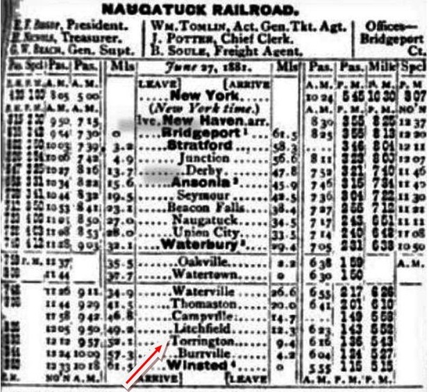
TORRINGTON1 [NRR, 1849; opened as WOLCOTTVILLE]
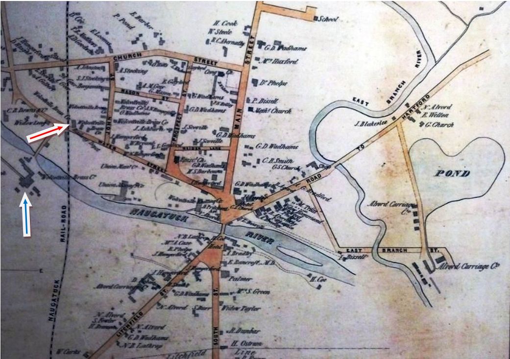
From the NRR's opening in 1849 until 1881, this stop in the town of Torrington was called WOLCOTTVILLE, a name that derived from Frederick Wolcott, one of the village's earliest industrialists who constructed a woolen mill in 1813. We have no photo of the first station but assume that it was the standard early NRR depot like NAUGATUCK1 at [1] or the somewhat larger DERBY1 at [2]. As seen on the 1852 map at [3], this station [red arrow] was located in the northeast quadrant of the Water St. grade crossing where there was convenient access for the metal-working plants in the village, including the Wolcottville, later Coe, brass mill [blue arrow]. Whatever its appearance, the Courant said that this station was "entirely consumed" by fire early in the morning of 3/2/1869 and "nothing was saved of any account but the safe." TORRINGTON1 was described as a combination station with the freight portion on the north end where the suspected arson fire began and with the ticket office and passenger rooms in the south part. [REFS: HDC/03/03/1869/03; HDC/03/19/1869/02][rev122913, rev092321, 052022]
From the NRR's opening in 1849 until 1881, this stop in the town of Torrington was called WOLCOTTVILLE, a name that derived from Frederick Wolcott, one of the village's earliest industrialists who constructed a woolen mill in 1813. We have no photo of the first station but assume that it was the standard early NRR depot like NAUGATUCK1 at [1] or the somewhat larger DERBY1 at [2]. As seen on the 1852 map at [3], this station [red arrow] was located in the northeast quadrant of the Water St. grade crossing where there was convenient access for the metal-working plants in the village, including the Wolcottville, later Coe, brass mill [blue arrow]. Whatever its appearance, the Courant said that this station was "entirely consumed" by fire early in the morning of 3/2/1869 and "nothing was saved of any account but the safe." TORRINGTON1 was described as a combination station with the freight portion on the north end where the suspected arson fire began and with the ticket office and passenger rooms in the south part. [REFS: HDC/03/03/1869/03; HDC/03/19/1869/02][rev122913, rev092321, 052022]
|

|
Torrington Historical Society
|
|
|
|
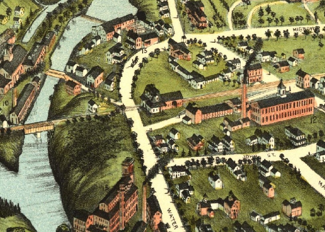
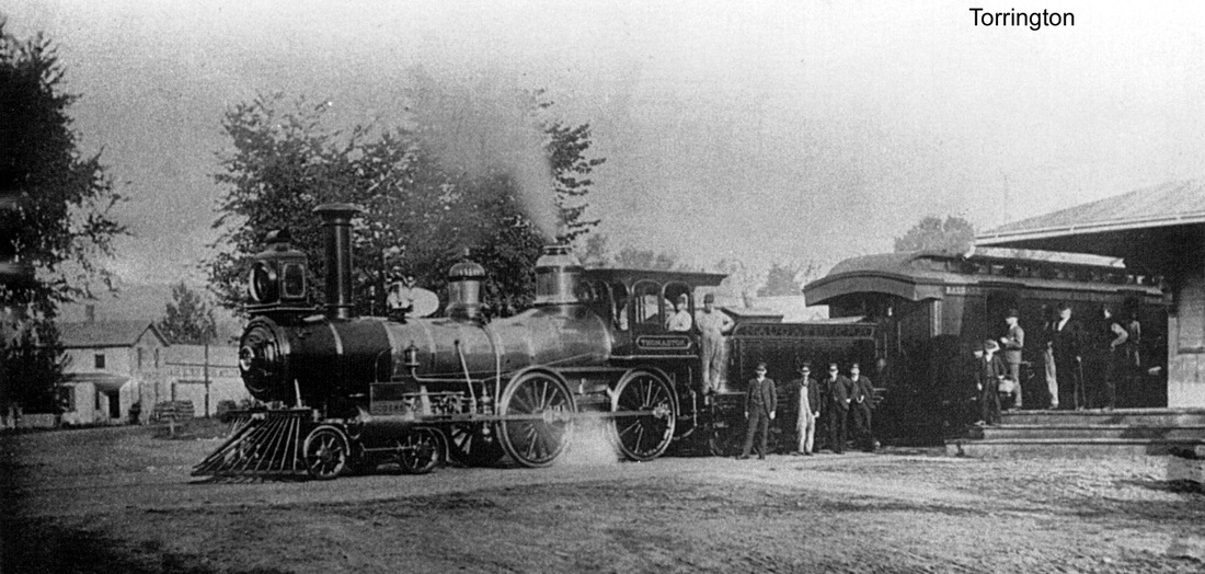
TORRINGTON2 [NRR, 1870]
This station probably dates to early 1870 though we cannot find a specific mention of its opening in the newspapers. A September, 1869 Courant article does read as follows: "Drawings have been completed of the new depot in Wolcottville. The building is to be 41 feet front and 95 feet deep, with an eight foot platform extending across the front and side, to be used as a passenger and freight depot. The passenger end of the building will have a French roof, surmounted with a balustrade and flagstaff. The upper rooms are to be used for railroad and telegraph offices. The rear end extends along the side of the track, and is of sufficient capacity for the accommodation of the large freight business which is done at that station." According to R&LHS notes at the Baker Library, the Bridgeport architectural firm of Lambert and Bunnell was paid $150 on 2/14/1870 for the plans. Various views are seen at [1-3] with the two-story facade facing Water St. The 1875 bird's-eye map of Wolcottville at [4] shows the depot from O.H. Bailey's perspective. This stop was dubbed TORRINGTON in March, 1881, apparently to follow the renaming of the post office. Interestingly, Orsamus R. Fyler, later a state railroad commissioner, was the postmaster under the old and new names when the transition was made. The 6/27/1881 timetable at [5] is probably the first to reflect the change, which was said by the Connecticut Western News, perhaps facetiously, to have caused "... no little inconvenience. It takes a newspaper five days to travel from Thomaston to Torrington, whereas, it could go to Wolcottville in half an hour. On the cars when 'Torrington' is called out, the passengers start, look around in a puzzled way, and ask, 'Is this Wolcottville?' Torringtonians think now that a 'change' isn't what it's cracked up to be." The timetable at [5] is dated 6/27/1881. The 1884 image at [6] looks west and shows the Thomaston about to lead a train south. As preparations were being made in 1898 for the new depot, the old one was maligned for its shortcomings much like we have seen elsewhere: "The little depot in use, with its queer style of architecture, soon to be done away with, was built during the war and has had no change of account since, but has consumed hogsheads of paint in the effort to make it presentable, while the inconveniences to which its location has subjected people in getting off the cars, have been almost unbearable. Under the new arrangements the freight track will run right through in such a way as to clear the room for the comfort of passengers in getting on or alighting from trains." [REFS: HDC/03/03/1869/03; HDC/03/19/1869/02; HDC/09/30/1869/04; B1014 (1870); HDC/05/15/1871/01; CRC18.1870.19; HDC/03/23/1881/03; CWN/04/13/1881/02; TR/10/22/1897/00; D94; R99][rev122913, 092321, 042923]
This station probably dates to early 1870 though we cannot find a specific mention of its opening in the newspapers. A September, 1869 Courant article does read as follows: "Drawings have been completed of the new depot in Wolcottville. The building is to be 41 feet front and 95 feet deep, with an eight foot platform extending across the front and side, to be used as a passenger and freight depot. The passenger end of the building will have a French roof, surmounted with a balustrade and flagstaff. The upper rooms are to be used for railroad and telegraph offices. The rear end extends along the side of the track, and is of sufficient capacity for the accommodation of the large freight business which is done at that station." According to R&LHS notes at the Baker Library, the Bridgeport architectural firm of Lambert and Bunnell was paid $150 on 2/14/1870 for the plans. Various views are seen at [1-3] with the two-story facade facing Water St. The 1875 bird's-eye map of Wolcottville at [4] shows the depot from O.H. Bailey's perspective. This stop was dubbed TORRINGTON in March, 1881, apparently to follow the renaming of the post office. Interestingly, Orsamus R. Fyler, later a state railroad commissioner, was the postmaster under the old and new names when the transition was made. The 6/27/1881 timetable at [5] is probably the first to reflect the change, which was said by the Connecticut Western News, perhaps facetiously, to have caused "... no little inconvenience. It takes a newspaper five days to travel from Thomaston to Torrington, whereas, it could go to Wolcottville in half an hour. On the cars when 'Torrington' is called out, the passengers start, look around in a puzzled way, and ask, 'Is this Wolcottville?' Torringtonians think now that a 'change' isn't what it's cracked up to be." The timetable at [5] is dated 6/27/1881. The 1884 image at [6] looks west and shows the Thomaston about to lead a train south. As preparations were being made in 1898 for the new depot, the old one was maligned for its shortcomings much like we have seen elsewhere: "The little depot in use, with its queer style of architecture, soon to be done away with, was built during the war and has had no change of account since, but has consumed hogsheads of paint in the effort to make it presentable, while the inconveniences to which its location has subjected people in getting off the cars, have been almost unbearable. Under the new arrangements the freight track will run right through in such a way as to clear the room for the comfort of passengers in getting on or alighting from trains." [REFS: HDC/03/03/1869/03; HDC/03/19/1869/02; HDC/09/30/1869/04; B1014 (1870); HDC/05/15/1871/01; CRC18.1870.19; HDC/03/23/1881/03; CWN/04/13/1881/02; TR/10/22/1897/00; D94; R99][rev122913, 092321, 042923]
|

|
|
|

|
|
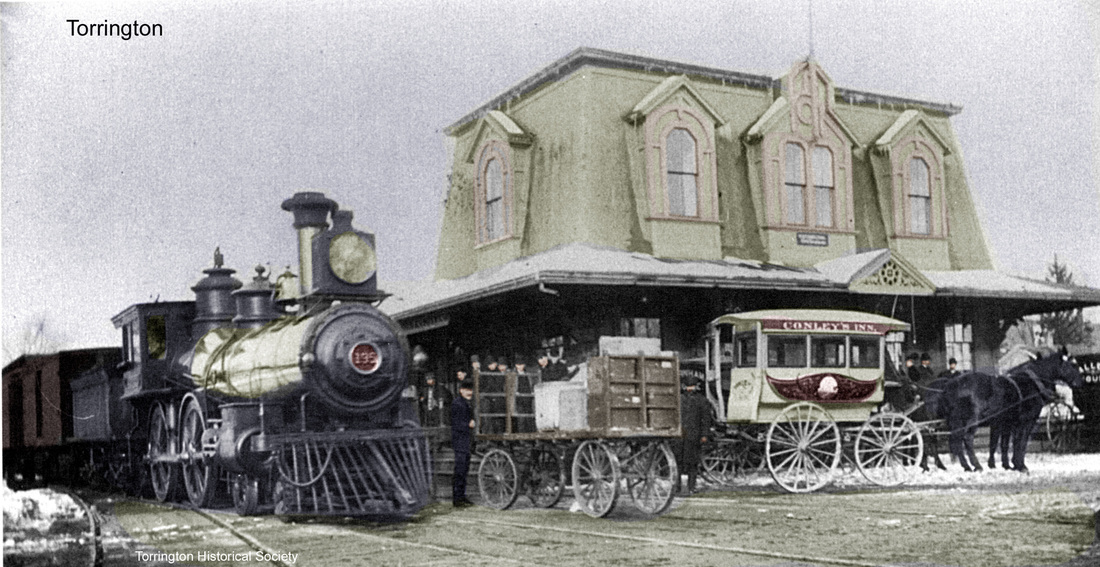
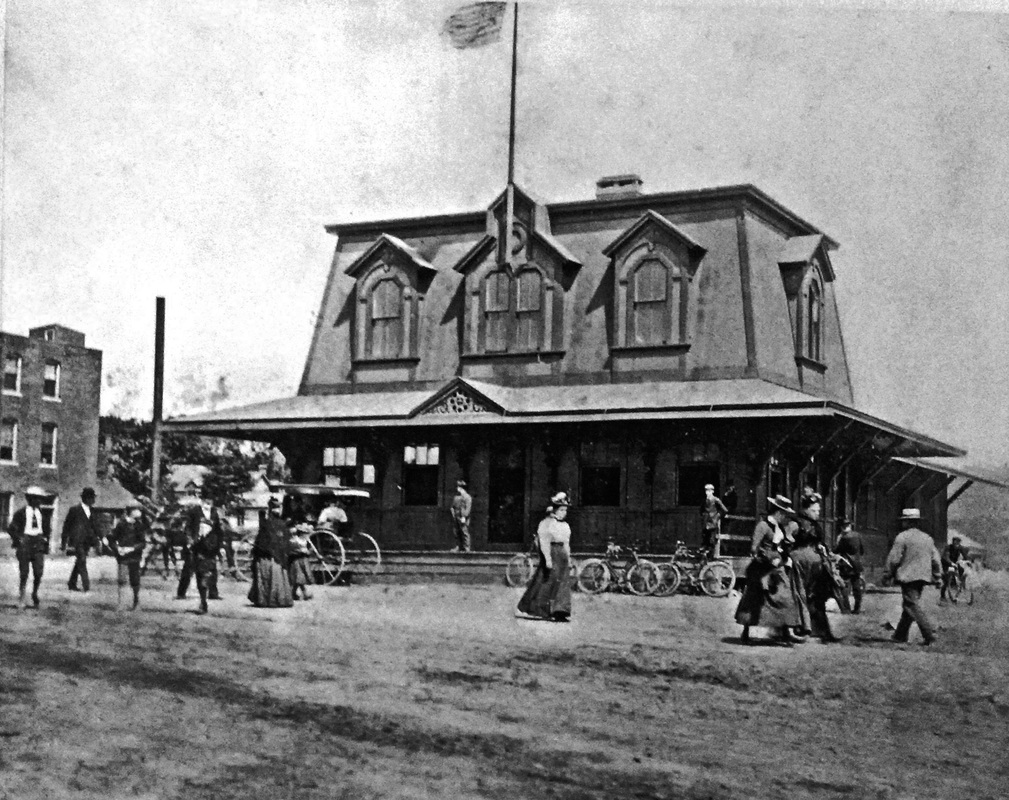
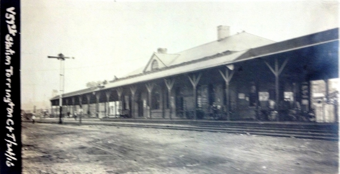
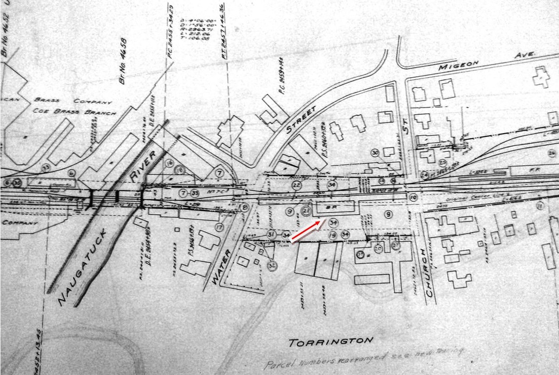
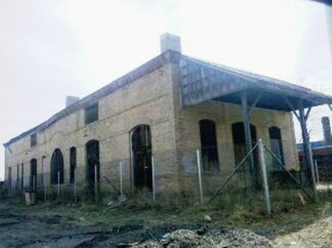
TORRINGTON3 [NYNH&H, 1898]
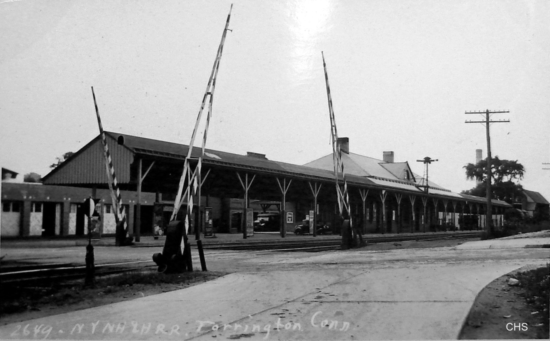
The station seems to have debuted in mid-1898 but once again we have found no specific reference to the opening date. A Torrington Register article titled "New Station at Last, Torrington's Hopes Realized" said on 10/22/1897 that, with assurances from Mr. Charles F. Brooker, president of Coe Brass Co. and a NYNH&H director, work was to begin right away. It continued by saying that "the new depot is to be one not simply suited for the present, but is to be built of the size and style looking forward to the future, the future that all see for this rapidly growing town. The depot is to be on the general style and plan of that in the city of Stamford, built of yellow brick with a slate roof. It will be a handsome structure, worthy of the town and one we can all be proud of." The new brick passenger and freight structures, now separate and more convenient for all, were built midway between Water and Church Sts., expressly to alleviate trains standing on the former thoroughfare. According to the paper, the new trackage through the redesigned station area was to be first used on 6/19/1898 and, though the old station was still standing and about to be torn down, one has to assume that service was in place at the new structure by that date. Passenger service ended on 12/3/1958 and, with freight service to Winsted lasting until 1963, the tracks from a point north of the station were taken up in that year. The subject of sporadic preservation efforts over the years, the 113-year-old station lost its battle for survival on 1/4/2011, over the cries of some that it was not saved and the relief of others that an eyesore was gone. It seems a shame that some way was not found to rehab it and put it to good use. The val photo at [1] is dated 7/24/1916. The view at [2] is likely of the north end of the station in horse-and-buggy days. The 6/30/1915 val map at [3] shows the complex network of tracks at the station which is indicated by our red arrow. The shot at [4] is Lewis H. Benton's #2649 taken in June, 1930. The 3/20/2010 photos at [5] and [6] are the last we got to take. [REFS: NHER/10/19/1897/11; TR/10/22/1897/00; TR/06/17/1898/03; CRC46.1898.19; HC/11/30/1966/30E; TR/07/22/2006/B1; TR/01/04/2011/A1; TR/01/05/2011/A1; TR/01/07/2011/A1; R99; D95][rev122913, 092321, 042923]
The station seems to have debuted in mid-1898 but once again we have found no specific reference to the opening date. A Torrington Register article titled "New Station at Last, Torrington's Hopes Realized" said on 10/22/1897 that, with assurances from Mr. Charles F. Brooker, president of Coe Brass Co. and a NYNH&H director, work was to begin right away. It continued by saying that "the new depot is to be one not simply suited for the present, but is to be built of the size and style looking forward to the future, the future that all see for this rapidly growing town. The depot is to be on the general style and plan of that in the city of Stamford, built of yellow brick with a slate roof. It will be a handsome structure, worthy of the town and one we can all be proud of." The new brick passenger and freight structures, now separate and more convenient for all, were built midway between Water and Church Sts., expressly to alleviate trains standing on the former thoroughfare. According to the paper, the new trackage through the redesigned station area was to be first used on 6/19/1898 and, though the old station was still standing and about to be torn down, one has to assume that service was in place at the new structure by that date. Passenger service ended on 12/3/1958 and, with freight service to Winsted lasting until 1963, the tracks from a point north of the station were taken up in that year. The subject of sporadic preservation efforts over the years, the 113-year-old station lost its battle for survival on 1/4/2011, over the cries of some that it was not saved and the relief of others that an eyesore was gone. It seems a shame that some way was not found to rehab it and put it to good use. The val photo at [1] is dated 7/24/1916. The view at [2] is likely of the north end of the station in horse-and-buggy days. The 6/30/1915 val map at [3] shows the complex network of tracks at the station which is indicated by our red arrow. The shot at [4] is Lewis H. Benton's #2649 taken in June, 1930. The 3/20/2010 photos at [5] and [6] are the last we got to take. [REFS: NHER/10/19/1897/11; TR/10/22/1897/00; TR/06/17/1898/03; CRC46.1898.19; HC/11/30/1966/30E; TR/07/22/2006/B1; TR/01/04/2011/A1; TR/01/05/2011/A1; TR/01/07/2011/A1; R99; D95][rev122913, 092321, 042923]

Tom Derwin Collection, NHRHTA.
|
|
|
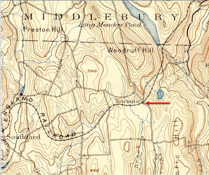
TOWANTIC1 [NY&NE, 1881]
This was another of the Leman Oatman 1881 NY&NE stations, this being of the smaller variety like MILL PLAIN. This depot in the town of OXFORD burned in 1894 and was replaced with an almost identical one. The location is shown a little right of center at our arrow on the 1893 topographic map. [REFS: NBE/11/17/1880/03: tin roof contract given. [rev010918, 042122]
This was another of the Leman Oatman 1881 NY&NE stations, this being of the smaller variety like MILL PLAIN. This depot in the town of OXFORD burned in 1894 and was replaced with an almost identical one. The location is shown a little right of center at our arrow on the 1893 topographic map. [REFS: NBE/11/17/1880/03: tin roof contract given. [rev010918, 042122]

Dave Peters Collection
|
Max Miller Collection
|
|
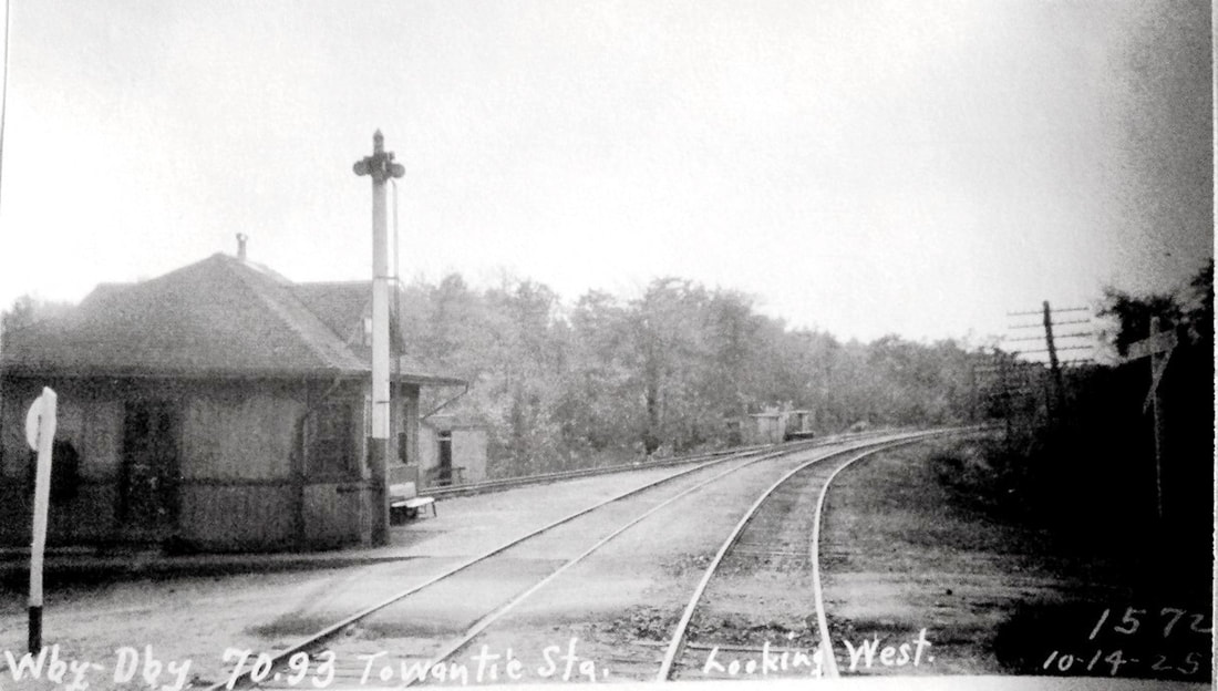
TOWANTIC2 [NY&NE, 1894]
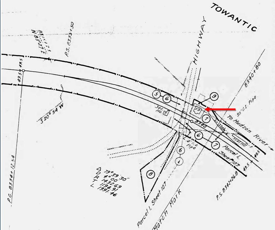
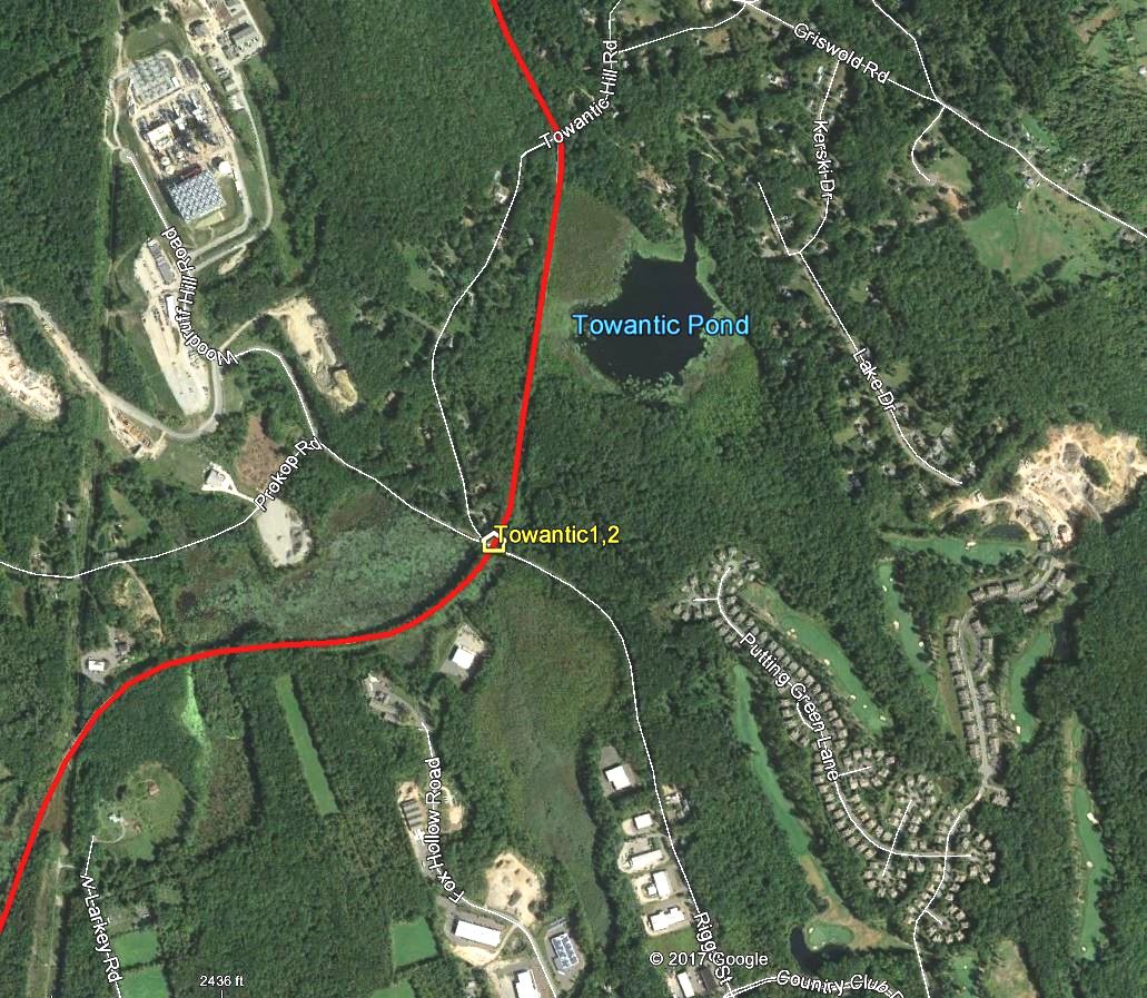
This station has a different foundation and there seems to be a horizontal break in the exterior finish, making it appear as the new one that the railroad commissioners mentioned in their 1894 annual report. Otherwise it seems identical to the preceding station. Note the locomotives double-heading in front of the station in the ICC valuation rear shot at [1], the 8/31/1916 date assuring us that this is the second station. The 10/14/1925 PUC inspection photo [2] looks west. The 1915 val map at [3] shows the layout of the station grounds; the [FP=framed, i.e. wooden, passenger] depot stood in the southwest quadrant of the grade crossing at our red arrow. The snippet at [4] is from our Track 11 Google Earth map and shows the intersection of Riggs St. with Towantic Hill and Woodruff Hill Rds. [REFS: CRC42.1894.22; HC/05/28/1904/07; D136] [rev010918, 042923]
This station has a different foundation and there seems to be a horizontal break in the exterior finish, making it appear as the new one that the railroad commissioners mentioned in their 1894 annual report. Otherwise it seems identical to the preceding station. Note the locomotives double-heading in front of the station in the ICC valuation rear shot at [1], the 8/31/1916 date assuring us that this is the second station. The 10/14/1925 PUC inspection photo [2] looks west. The 1915 val map at [3] shows the layout of the station grounds; the [FP=framed, i.e. wooden, passenger] depot stood in the southwest quadrant of the grade crossing at our red arrow. The snippet at [4] is from our Track 11 Google Earth map and shows the intersection of Riggs St. with Towantic Hill and Woodruff Hill Rds. [REFS: CRC42.1894.22; HC/05/28/1904/07; D136] [rev010918, 042923]
Connecticut Historical Society
|
|
|
|
|
|
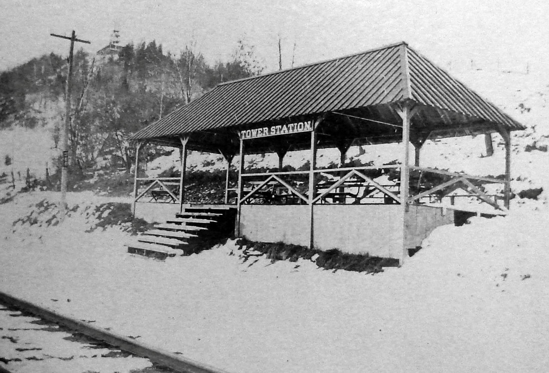
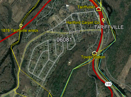
TOWER STATION [CNE&W, 1889 ]
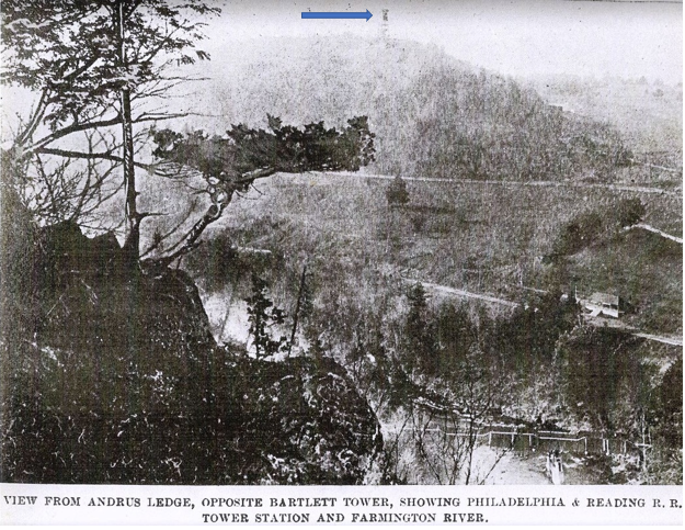
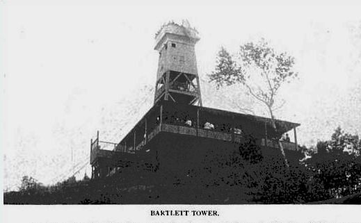
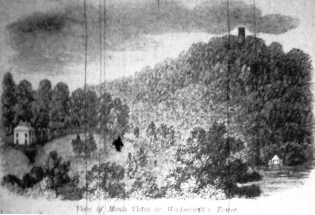
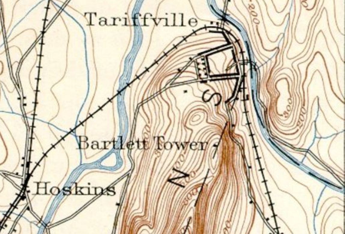
This station in the town of Simsbury, just above the Bloomfield line, was built in 1889 by Matthew H. Bartlett. to give visitors easy access to his tower and recreational facilities on Talcott Mountain. An interesting article in Connecticut Magazine says lookout structures there dated back to the 1830s but that the fourth tower seen at [3] was the tallest at 70 feet high. Bartlett had built the first of his two towers in 1867, and when it was sold in 1889, he felt as though he needed to build a new one bigger, better and taller so as not to deprive the public of the wonderful views toward Hartford, Newgate Prison, and southward as far as Prospect, CT. The railroad took good advantage of this tourist destination from the start. The CW had opened late in 1871 and early in the next season was offering joint fares that included admission to the tower, leaving passengers at SIMSBURY to complete the journey by coach or carriage to the old tower which had such amenities as a telescope, 'lunching' tables, hammocks, swings, croquet, piano, bowling alleys, and dance pavilion. Presumably the new one had much the same or better. The new one was easier to access from TARIFFVILLE and trains began seasonal stops from April to October in 1889 at Bartlett's TOWER STATION. A 6/16/1890 CNE&W timetable has a footnote saying that "Trains Nos. 21 and 14 will stop at Bartlett's Tower for 15 or more passengers," smaller parties detraining at TARIFFVILE and journeying by carriage. At first Bartlett only built a platform but by May, 1891 the newspaper reported that he had added a roof, as seen in the photo at [1] ahead of the tower atop the mountain. The westward view at [2] shows the station in the lower foreground from Andrus Ledge across the river in East Granby. The undated view at [3] shows people enjoying the view at the several levels the tower offered. The woodcut at [4] shows Bartlett's first tower. The 1892 topographic map at [5] shows this station as Bartlett Tower. Conveyance from TOWER STATION up the mountain was available for those "not wishing to walk," a trek that was pretty long and steep. Bartlett retired from public life in 1899, selling the tower in 1898 to Mrs. Antoinette Eno Wood, scion of a well-known local family, who made it into a private family retreat, although serving tea to occasional group visits that she entertained. Even as the tower was being closed to the public and the battle to complete the Tariffville Extension was being fought, the Springfield Republican was extolling visits to the tower from which the Massachusetts city could be seen. The tower burned on 3/24/1936 in a fire that could be seen for miles; all that remains today is a chimney. Neither it nor its predecessors on Talcott Mountain should be confused with the 150-ft Heublein Tower that stands today. Coincidentally it was built in 1914 a few miles south at the location of Bartlett's first tower and, adding more irony, Bartlett died on December 14th in that same year at the age of 81. The location of TOWER STATION is seen at [6] on the snippet from our Track 11 Google Earth map. [REFS: HDC/09/02/1879/04; HC/04/15/1889/08; HC/08/04/1889/08; HC/04/28/1891/06; HC/05/12/1891/06; CM1.180 (1895); HC/01/27/1898/03; SR/04/05/1899/05; HC/10/12/1903/08; HC/10/04/1914/X3; HC/12/15/1914/04; HC/05/25/1936/01] [rev051716, 040819, 111719, 042823]
This station in the town of Simsbury, just above the Bloomfield line, was built in 1889 by Matthew H. Bartlett. to give visitors easy access to his tower and recreational facilities on Talcott Mountain. An interesting article in Connecticut Magazine says lookout structures there dated back to the 1830s but that the fourth tower seen at [3] was the tallest at 70 feet high. Bartlett had built the first of his two towers in 1867, and when it was sold in 1889, he felt as though he needed to build a new one bigger, better and taller so as not to deprive the public of the wonderful views toward Hartford, Newgate Prison, and southward as far as Prospect, CT. The railroad took good advantage of this tourist destination from the start. The CW had opened late in 1871 and early in the next season was offering joint fares that included admission to the tower, leaving passengers at SIMSBURY to complete the journey by coach or carriage to the old tower which had such amenities as a telescope, 'lunching' tables, hammocks, swings, croquet, piano, bowling alleys, and dance pavilion. Presumably the new one had much the same or better. The new one was easier to access from TARIFFVILLE and trains began seasonal stops from April to October in 1889 at Bartlett's TOWER STATION. A 6/16/1890 CNE&W timetable has a footnote saying that "Trains Nos. 21 and 14 will stop at Bartlett's Tower for 15 or more passengers," smaller parties detraining at TARIFFVILE and journeying by carriage. At first Bartlett only built a platform but by May, 1891 the newspaper reported that he had added a roof, as seen in the photo at [1] ahead of the tower atop the mountain. The westward view at [2] shows the station in the lower foreground from Andrus Ledge across the river in East Granby. The undated view at [3] shows people enjoying the view at the several levels the tower offered. The woodcut at [4] shows Bartlett's first tower. The 1892 topographic map at [5] shows this station as Bartlett Tower. Conveyance from TOWER STATION up the mountain was available for those "not wishing to walk," a trek that was pretty long and steep. Bartlett retired from public life in 1899, selling the tower in 1898 to Mrs. Antoinette Eno Wood, scion of a well-known local family, who made it into a private family retreat, although serving tea to occasional group visits that she entertained. Even as the tower was being closed to the public and the battle to complete the Tariffville Extension was being fought, the Springfield Republican was extolling visits to the tower from which the Massachusetts city could be seen. The tower burned on 3/24/1936 in a fire that could be seen for miles; all that remains today is a chimney. Neither it nor its predecessors on Talcott Mountain should be confused with the 150-ft Heublein Tower that stands today. Coincidentally it was built in 1914 a few miles south at the location of Bartlett's first tower and, adding more irony, Bartlett died on December 14th in that same year at the age of 81. The location of TOWER STATION is seen at [6] on the snippet from our Track 11 Google Earth map. [REFS: HDC/09/02/1879/04; HC/04/15/1889/08; HC/08/04/1889/08; HC/04/28/1891/06; HC/05/12/1891/06; CM1.180 (1895); HC/01/27/1898/03; SR/04/05/1899/05; HC/10/12/1903/08; HC/10/04/1914/X3; HC/12/15/1914/04; HC/05/25/1936/01] [rev051716, 040819, 111719, 042823]
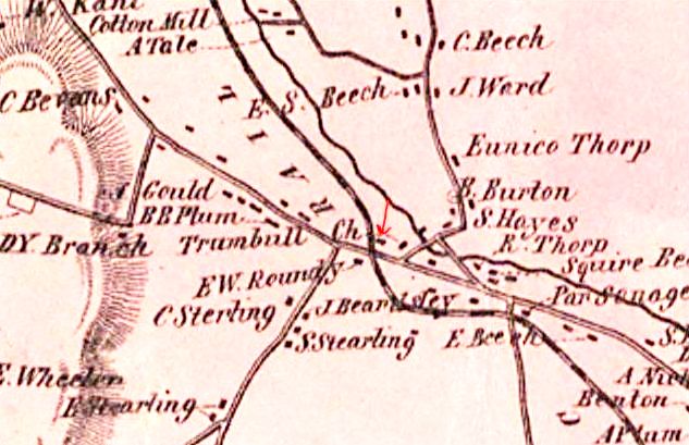
TRUMBULL1 [HRR, 1840]
This station was originally a flag stop called TRUMBULL CHURCH and likely dates back to the 1840 opening of the HRR. It appears as TRUMBULL on an 1849 broadside. A retrospective Bridgeport Post article in 1936 said that there was only a platform here on the west side of the track to start with, later augmented by a small shanty. The block at the red arrow on the 1856FC map may be the shanty, then on the east side of the track. [REFS: C56]
This station was originally a flag stop called TRUMBULL CHURCH and likely dates back to the 1840 opening of the HRR. It appears as TRUMBULL on an 1849 broadside. A retrospective Bridgeport Post article in 1936 said that there was only a platform here on the west side of the track to start with, later augmented by a small shanty. The block at the red arrow on the 1856FC map may be the shanty, then on the east side of the track. [REFS: C56]

Copyright Trumbull Historical Society
TRUMBULL2 [HRR, 1880?]
The rare photo is courtesy of the Trumbull Historical Society and shows the second station probably after 1889 when, according to the Register, the name was simplified to TRUMBULL. This stop does not show up on timetables and RRM maps until 1882. Some newspaper articles said this structure was to be retained as a freight depot but it appears to have come down upon the building of the new combination freight and passenger station that is seen in our next entry. [REFS: 1851,1858,1871,1875TT; NHJC/07/21/1877/02; 1883TT; RRM1882; NHER/05/31/1889/04; NHER/08/16/1889/04; NBE/02/24/1905/02; BEP/02/23/1936/??][rev042823]
The rare photo is courtesy of the Trumbull Historical Society and shows the second station probably after 1889 when, according to the Register, the name was simplified to TRUMBULL. This stop does not show up on timetables and RRM maps until 1882. Some newspaper articles said this structure was to be retained as a freight depot but it appears to have come down upon the building of the new combination freight and passenger station that is seen in our next entry. [REFS: 1851,1858,1871,1875TT; NHJC/07/21/1877/02; 1883TT; RRM1882; NHER/05/31/1889/04; NHER/08/16/1889/04; NBE/02/24/1905/02; BEP/02/23/1936/??][rev042823]
National Archives
|
|
|
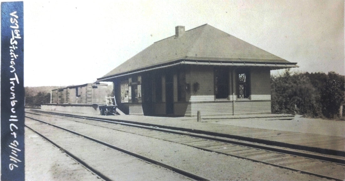
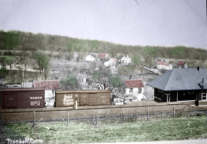
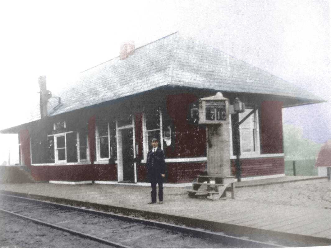
TRUMBULL3 [NYNH&H, 1905]
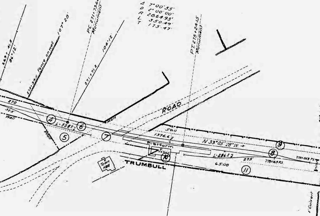
The railroad commissioners reported in 1905 that a new station had been built here. This combination station stood just north of the location of the old one. A May Bee article, has many valuable details about the ongoing construction and plans. The contract was let to A.H. Milkins of Norwalk. Measuring 22x57 feet, the depot was to clapboarded on the outside up as far as the windows and shingled the rest of the way, a detail which is born out in the photos. The 25x21-ft freight room was to be on the north side with a door on the east side so teams could drive right up for loading and unloading. Measurements in the station showed the baggage room at 10x10, the waiting room 21x31, the office 13x10 at the bay window on the west side; interior of Southern pine; platform 280 feet long, 8-14 feet in width; roof eaves to overhang all the way around. The depot was completed by 6/16/1905 when the Bee reported that "Trumbull people feel quite flattered over the compliment paid to them by the Railroad Company in the form of so substantial and artistic a depot. Evidently the company at least has faith in the future of Trumbull. Not a little credit for this is due to Mr. Beach, the station agent, under whose administrations Trumbull has obtained freight and express conveniences, which have so increased the business of their departments as to warrant the present enlargement. It is rumored, also, that Trumbull is to have a regular telegraph office." The ICC valuation photo at [1] is dated 9/11/1916 and looks north. The photo at [2] is an eastward view ca. 1920 with box cars on the house track; Al Weaver's colorization brings out the details. Agent Beach stands proudly in the shot at [3]; the Dutch clock says the last northbound train passed at 7:10. The 6/30/1915 ICC valuation map at [4] shows the layout of the grounds, north being to the right. Passenger service was discontinued in 1932 and track from Bridgeport to the Monroe line was torn up in 1940, around which time TRUMBULL3 was sold. The Bridgeport Post reported with feigned horror that the depot was to be moved and possibly used as a hot dog stand. We do not yet know if that was its fate. [REFS: NBE/05/05/1905/03; NBE/05/19/1905/03; NBE/06/16/1905/03; CRC53.1905.26; K56; NHAR34.1905.7; BEP/02/23/1936][rev123017, 021322, 042823]
The railroad commissioners reported in 1905 that a new station had been built here. This combination station stood just north of the location of the old one. A May Bee article, has many valuable details about the ongoing construction and plans. The contract was let to A.H. Milkins of Norwalk. Measuring 22x57 feet, the depot was to clapboarded on the outside up as far as the windows and shingled the rest of the way, a detail which is born out in the photos. The 25x21-ft freight room was to be on the north side with a door on the east side so teams could drive right up for loading and unloading. Measurements in the station showed the baggage room at 10x10, the waiting room 21x31, the office 13x10 at the bay window on the west side; interior of Southern pine; platform 280 feet long, 8-14 feet in width; roof eaves to overhang all the way around. The depot was completed by 6/16/1905 when the Bee reported that "Trumbull people feel quite flattered over the compliment paid to them by the Railroad Company in the form of so substantial and artistic a depot. Evidently the company at least has faith in the future of Trumbull. Not a little credit for this is due to Mr. Beach, the station agent, under whose administrations Trumbull has obtained freight and express conveniences, which have so increased the business of their departments as to warrant the present enlargement. It is rumored, also, that Trumbull is to have a regular telegraph office." The ICC valuation photo at [1] is dated 9/11/1916 and looks north. The photo at [2] is an eastward view ca. 1920 with box cars on the house track; Al Weaver's colorization brings out the details. Agent Beach stands proudly in the shot at [3]; the Dutch clock says the last northbound train passed at 7:10. The 6/30/1915 ICC valuation map at [4] shows the layout of the grounds, north being to the right. Passenger service was discontinued in 1932 and track from Bridgeport to the Monroe line was torn up in 1940, around which time TRUMBULL3 was sold. The Bridgeport Post reported with feigned horror that the depot was to be moved and possibly used as a hot dog stand. We do not yet know if that was its fate. [REFS: NBE/05/05/1905/03; NBE/05/19/1905/03; NBE/06/16/1905/03; CRC53.1905.26; K56; NHAR34.1905.7; BEP/02/23/1936][rev123017, 021322, 042823]
TUCKER [> WEST CHESHIRE]
|
|
|
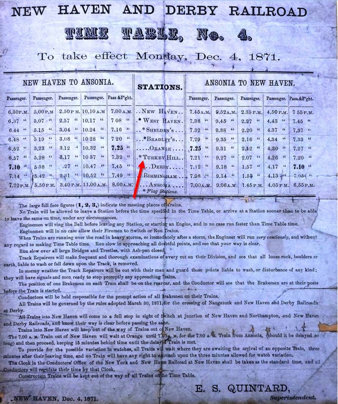
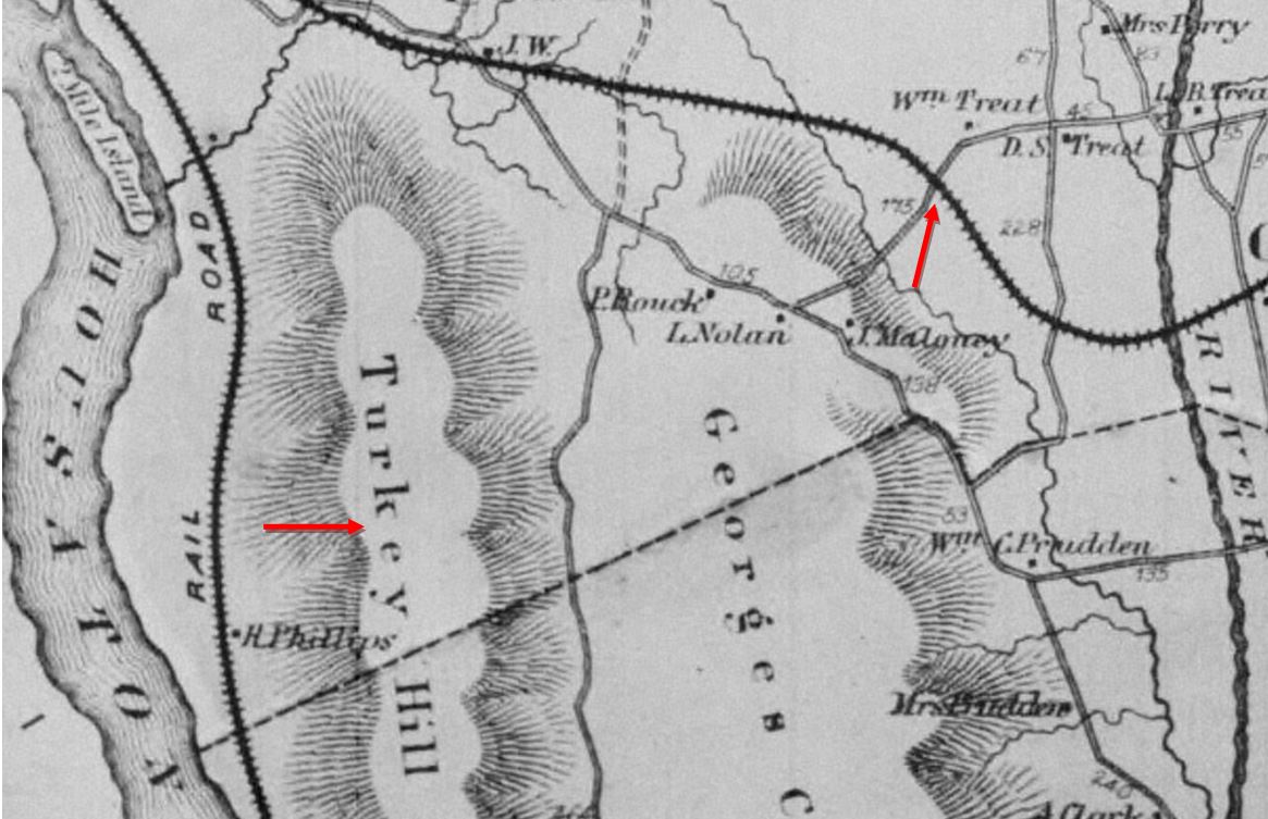
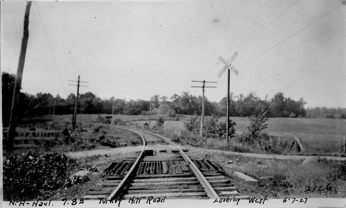
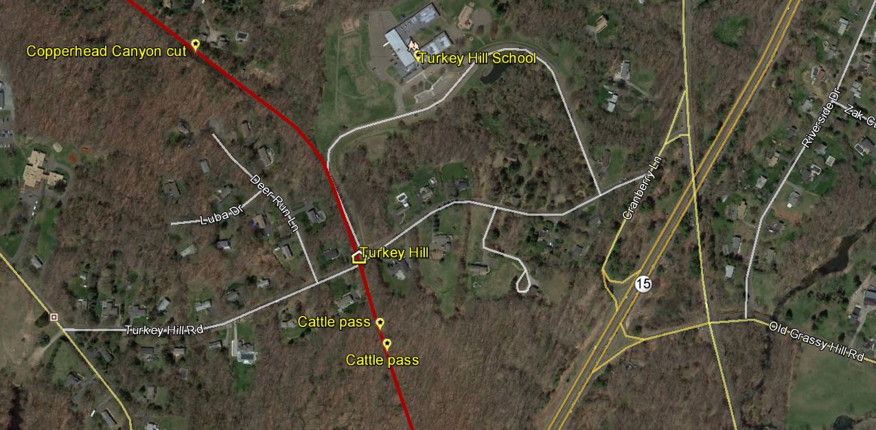
TURKEY HILL [NH&D, 1871]
This was an NH&D flag stop in the town of Orange on the railroad's opening in 1871. It appears to have been eliminated ca. 1882. It has always been of interest that the 1868 Beers Atlas of New Haven County has the NH&D ROW already laid out and seeming to be in existence three years before the railroad was completed. Better if it had been labeled 'Proposed' but nevertheless the image at [1] shows the line and our red arrows indicate both the namesake hill and the flag stop location. The 6/27/1927 PUC photo at [2] looks west at the crossing. Today, the Turkey Hill School exit driveway utilizes the old NH&D ROW, as seen on the Track 11 Google Earth map snippet at [3]. The 12/4/1871 timetable at [4] shows the stop as five minutes west of Orange Center. There may have been a small shed here or just a platform or nothing at all. [REFS: PL4.1.38 (Jan. 1883): no][rev052217, 021322]
This was an NH&D flag stop in the town of Orange on the railroad's opening in 1871. It appears to have been eliminated ca. 1882. It has always been of interest that the 1868 Beers Atlas of New Haven County has the NH&D ROW already laid out and seeming to be in existence three years before the railroad was completed. Better if it had been labeled 'Proposed' but nevertheless the image at [1] shows the line and our red arrows indicate both the namesake hill and the flag stop location. The 6/27/1927 PUC photo at [2] looks west at the crossing. Today, the Turkey Hill School exit driveway utilizes the old NH&D ROW, as seen on the Track 11 Google Earth map snippet at [3]. The 12/4/1871 timetable at [4] shows the stop as five minutes west of Orange Center. There may have been a small shed here or just a platform or nothing at all. [REFS: PL4.1.38 (Jan. 1883): no][rev052217, 021322]
|

|
|
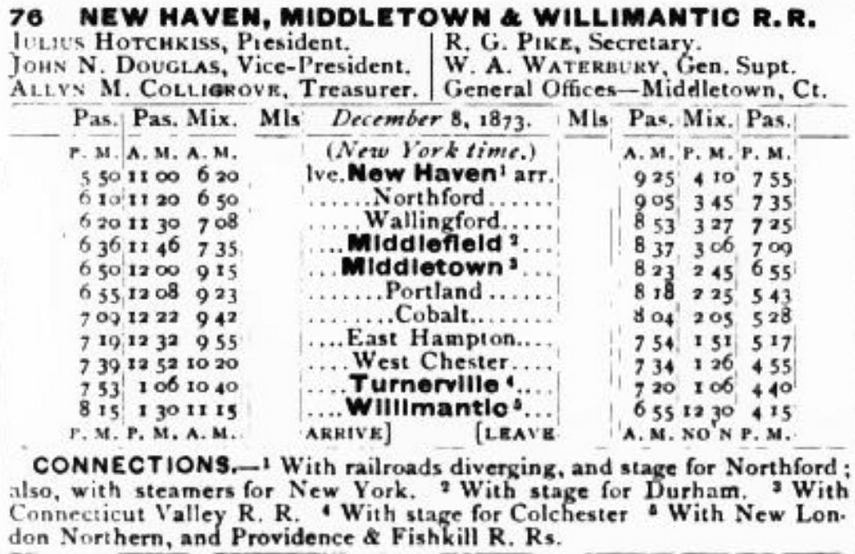
TURNERVILLE1 [NHM&W, 1873]
This stop in the town of Hebron was established by the NHM&W when the road was completed from Middletown to Willimantic in 1873. In their 1880 annual report, the railroad commissioners say that complaint had been made about the platform here needing repair "... but in the uncertainty and delay attending the proposed erection of a new depot, nothing of importance has yet been done there." 'New depot' has to mean a completely new building because a September, 1885 newspaper article tells us that "An old building belonging to village namesake P.W. Turner of Turnerville at the Air Line terminus of the Colchester Branch railroad, and used as a depot, and also by the owner as a store, was burned on Friday afternoon...," which puts the fire date at 9/25/1885. So TURNERVILLE1 was in Turner's store. As seen at [1] in our next entry, the store stood just west of TURNERVILE2 and was rebuilt there . Phineas W. Turner, of course, owned the village and the silk mill which was the area's major employer. He was one of the foremost advocates of the railroad and also an NHM&W director. A "cheap temporary" station was used until the village's first actual depot could be built in the next year. The 1855 Colton map of Connecticut at [1] shows town of Hebron at the center and the planned New York & Boston RR running through it 18 years prior to the opening of the road as the NHM&W. The 1867 map at [2] shows the small village, the silk mill and North Pond which powered the mill. The body of water is known today as Amston Lake. The 12/8/1873 timetable at [3] was issued just after the railroad's opening and shows TURNERVILLE between WEST CHESTER (sic) and WILLIMANTIC. [REFS: CRC27.1880.28; HDC/09/28/1885/04; NHAR14.1886.11; K91][rev121620, 122721]
This stop in the town of Hebron was established by the NHM&W when the road was completed from Middletown to Willimantic in 1873. In their 1880 annual report, the railroad commissioners say that complaint had been made about the platform here needing repair "... but in the uncertainty and delay attending the proposed erection of a new depot, nothing of importance has yet been done there." 'New depot' has to mean a completely new building because a September, 1885 newspaper article tells us that "An old building belonging to village namesake P.W. Turner of Turnerville at the Air Line terminus of the Colchester Branch railroad, and used as a depot, and also by the owner as a store, was burned on Friday afternoon...," which puts the fire date at 9/25/1885. So TURNERVILLE1 was in Turner's store. As seen at [1] in our next entry, the store stood just west of TURNERVILE2 and was rebuilt there . Phineas W. Turner, of course, owned the village and the silk mill which was the area's major employer. He was one of the foremost advocates of the railroad and also an NHM&W director. A "cheap temporary" station was used until the village's first actual depot could be built in the next year. The 1855 Colton map of Connecticut at [1] shows town of Hebron at the center and the planned New York & Boston RR running through it 18 years prior to the opening of the road as the NHM&W. The 1867 map at [2] shows the small village, the silk mill and North Pond which powered the mill. The body of water is known today as Amston Lake. The 12/8/1873 timetable at [3] was issued just after the railroad's opening and shows TURNERVILLE between WEST CHESTER (sic) and WILLIMANTIC. [REFS: CRC27.1880.28; HDC/09/28/1885/04; NHAR14.1886.11; K91][rev121620, 122721]
Roy Tennant photo
|
New Haven Museum
|
|
|

|
|
 Al Lawrence Collection
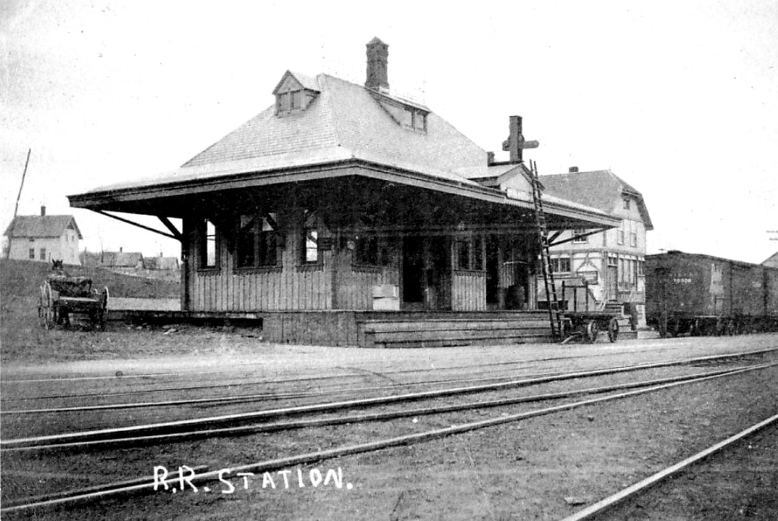
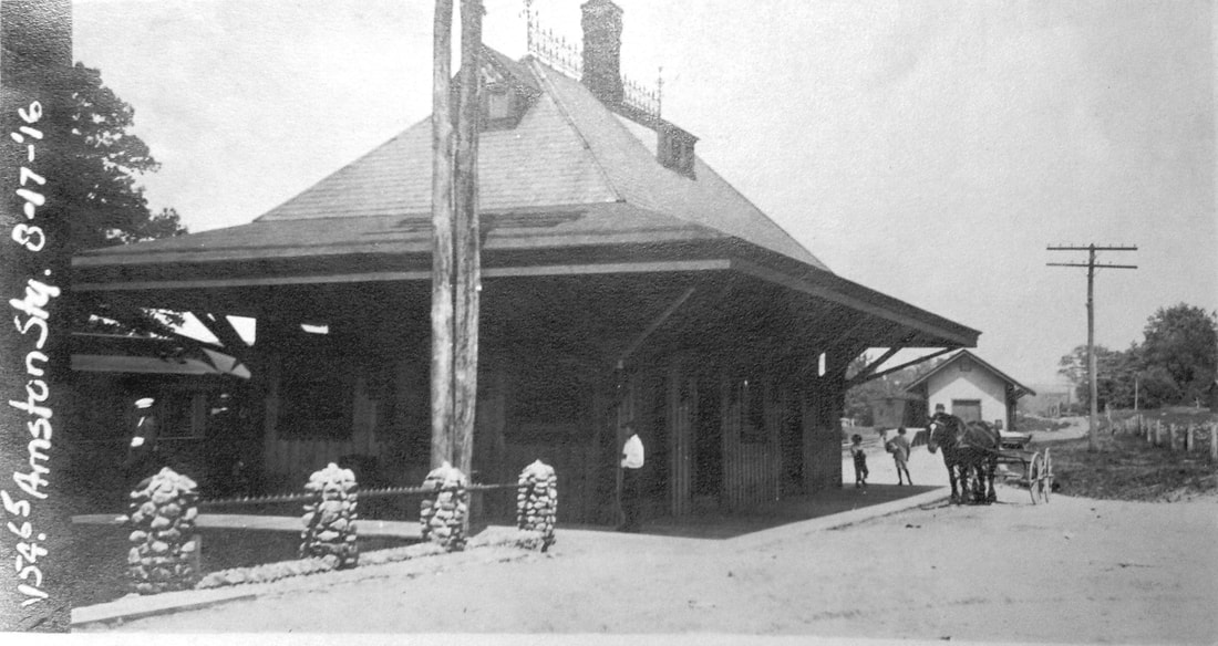
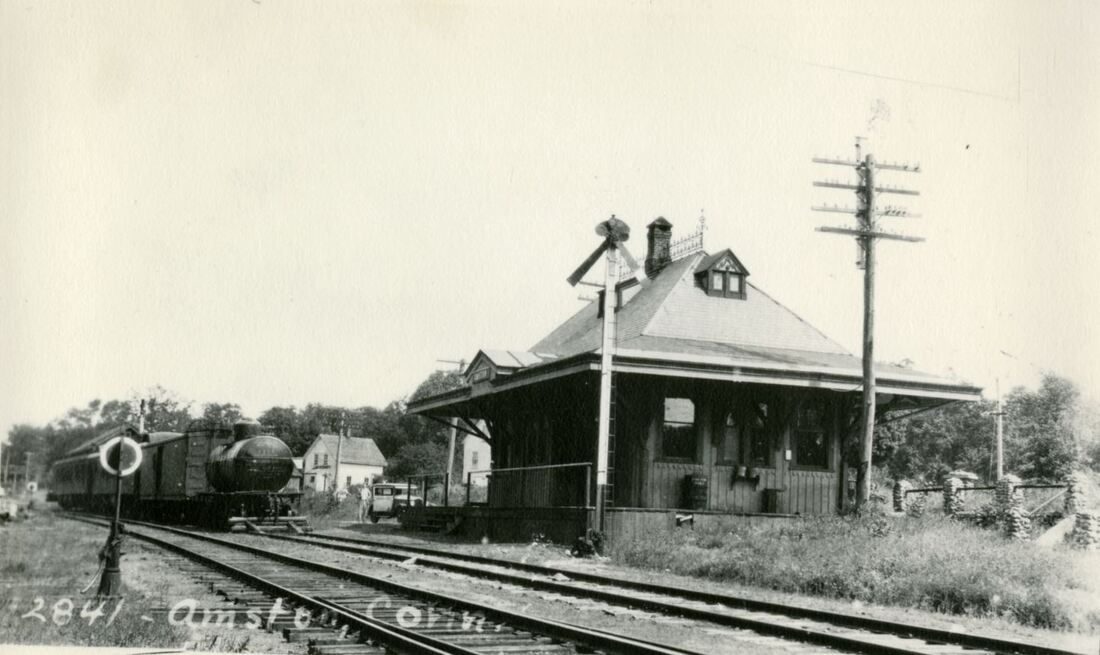
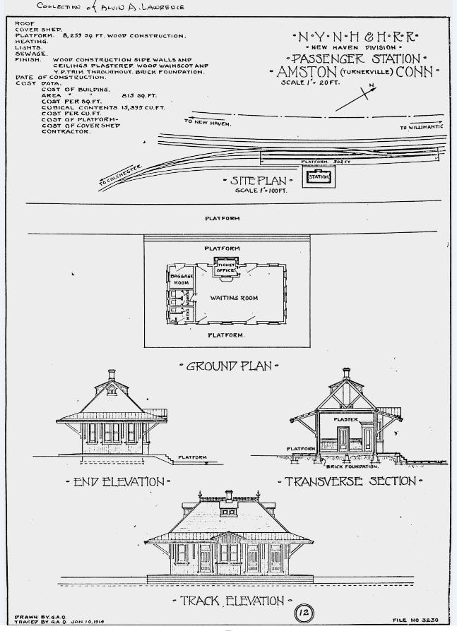
TURNERVILLE2 [NYNH&H, 1886; later AMSTON]
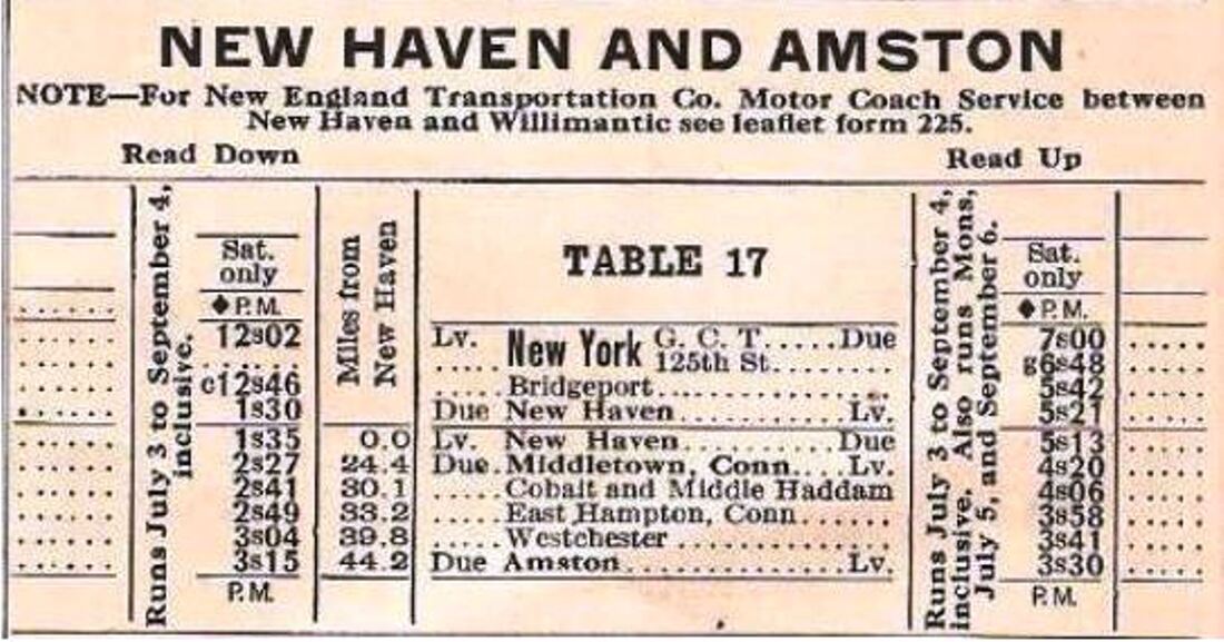
The railroad commissioners tell us in their 1886 annual report, issued in January, 1887, that "... a new and tasteful passenger station has been erected at Turnerville at a cost of about $4,000, and also a new freight house at the same place." The station that served the village was stylish and architecturally distinctive, a close copy of EAST NORWALK1 which was built in 1885. The photo at [1] looks southwestward, with the general store beyond the depot. Note the station's undersized dormers matching front/back and side/side only, the front-facing gable breaking the roof line in the center and the old wooden order board. The image at [2] is from the NY&BAL 1886 Index Map atlas and shows the new station. The renaming as AMSTON came in 1913 after the purchase of the entire village in the previous year by New York industrialist Charles M. Ams for the purpose of manufacturing automobiles here. The post office name was changed as well, the Courant saying however, without further explanation, that the railroad requested it and the village "blushingly" acceded. The energetic Ams was involved in many industrial ventures in the tri-state area, one of them the Max-Ams plant in Bridgeport; his son was named Max! Reportedly consisting of 30 houses, two small factories, a general store and a hotel, the village that Ams was about to revitalize was said to be "deserted" at the time by one newspaper. The 8/17/1916 val photo at [3] looks eastward with the freight house in the distance. The image at [4] is Lewis H. Benton's photo #2841 taken on 9/7/1931, the exact date verified in accomplice Irving Drake's hand on another copy we have of this print. Drake and his auto are seen in the middle distance in the Benton photo. By this time and certainly before, a signal mast has replaced the old roof-top order board. The image at [5] is of the #1392 on the point of a two-coach summer train that ran in the 1930s. Table 17 from our 4/25/1937 Form 200 at [6] shows the train originating at Grand Central Terminal. Great Depression aside, vacationers were still coming up to what might be called the Central Connecticut Lakes District. With Pocotopaug and Amston Lakes and others as far away as Moodus within reach, summer cottages that rented by the week were plentiful. By 1937 when it is likely seen here, it was a Saturday-only run, unnumbered in the timetable and thus requiring Extra flags. The straight-up smoke indicates that the engine is at a standstill and we can see the engineer looking to the rear for the signal to back up to the Colchester wye for the return trip to GCT. The last timetable appearance is 8/25/1937 and this photo may be of the final run on 9/6/1937. Our 1938 building inventory does not show AMSTON, likely meaning that the station had already been disposed of; the photo at [5] may well be the last ever taken. While the factory plans never came to fruition, Ams opened an ornithological research center and preserve. "Amston, Where Birds of a Feather Flock Together" was the title of one 1919 news article. Ams died on 5/26/1930. A real estate consortium purchased the old North Pond from his estate and today the lake association claims the waters are still pristine because motorized craft are forbidden on it. The snippet at [7] is the 1/10/1914 tracing of the architectural plan. A copy of this tracing was in the papers of the late Ed Sweeney of Norwood, MA and supplied to us by long-time TCS contributor Richard Fleischer of Newton Centre, MA. [REFS: CRC34.1886.11; NHAR15.1886.10; SUN/10/25/1912/03; NMB/12/06/1912/06; NMB/05/21/1913/08; BEF/08/24/1916/02; NMB/01/29/1917/09; HC/04/13/1919/X3; HC/10/23/1921/10; LWTT6/29/1914rev: first to show AMSTON; NYT/05/27/1930/25; HC/07/01/1931/15; SSRR 10/20/1938: no AMSTON; K92-93][rev042013, 121620, 092221, 103021, 042122]
The railroad commissioners tell us in their 1886 annual report, issued in January, 1887, that "... a new and tasteful passenger station has been erected at Turnerville at a cost of about $4,000, and also a new freight house at the same place." The station that served the village was stylish and architecturally distinctive, a close copy of EAST NORWALK1 which was built in 1885. The photo at [1] looks southwestward, with the general store beyond the depot. Note the station's undersized dormers matching front/back and side/side only, the front-facing gable breaking the roof line in the center and the old wooden order board. The image at [2] is from the NY&BAL 1886 Index Map atlas and shows the new station. The renaming as AMSTON came in 1913 after the purchase of the entire village in the previous year by New York industrialist Charles M. Ams for the purpose of manufacturing automobiles here. The post office name was changed as well, the Courant saying however, without further explanation, that the railroad requested it and the village "blushingly" acceded. The energetic Ams was involved in many industrial ventures in the tri-state area, one of them the Max-Ams plant in Bridgeport; his son was named Max! Reportedly consisting of 30 houses, two small factories, a general store and a hotel, the village that Ams was about to revitalize was said to be "deserted" at the time by one newspaper. The 8/17/1916 val photo at [3] looks eastward with the freight house in the distance. The image at [4] is Lewis H. Benton's photo #2841 taken on 9/7/1931, the exact date verified in accomplice Irving Drake's hand on another copy we have of this print. Drake and his auto are seen in the middle distance in the Benton photo. By this time and certainly before, a signal mast has replaced the old roof-top order board. The image at [5] is of the #1392 on the point of a two-coach summer train that ran in the 1930s. Table 17 from our 4/25/1937 Form 200 at [6] shows the train originating at Grand Central Terminal. Great Depression aside, vacationers were still coming up to what might be called the Central Connecticut Lakes District. With Pocotopaug and Amston Lakes and others as far away as Moodus within reach, summer cottages that rented by the week were plentiful. By 1937 when it is likely seen here, it was a Saturday-only run, unnumbered in the timetable and thus requiring Extra flags. The straight-up smoke indicates that the engine is at a standstill and we can see the engineer looking to the rear for the signal to back up to the Colchester wye for the return trip to GCT. The last timetable appearance is 8/25/1937 and this photo may be of the final run on 9/6/1937. Our 1938 building inventory does not show AMSTON, likely meaning that the station had already been disposed of; the photo at [5] may well be the last ever taken. While the factory plans never came to fruition, Ams opened an ornithological research center and preserve. "Amston, Where Birds of a Feather Flock Together" was the title of one 1919 news article. Ams died on 5/26/1930. A real estate consortium purchased the old North Pond from his estate and today the lake association claims the waters are still pristine because motorized craft are forbidden on it. The snippet at [7] is the 1/10/1914 tracing of the architectural plan. A copy of this tracing was in the papers of the late Ed Sweeney of Norwood, MA and supplied to us by long-time TCS contributor Richard Fleischer of Newton Centre, MA. [REFS: CRC34.1886.11; NHAR15.1886.10; SUN/10/25/1912/03; NMB/12/06/1912/06; NMB/05/21/1913/08; BEF/08/24/1916/02; NMB/01/29/1917/09; HC/04/13/1919/X3; HC/10/23/1921/10; LWTT6/29/1914rev: first to show AMSTON; NYT/05/27/1930/25; HC/07/01/1931/15; SSRR 10/20/1938: no AMSTON; K92-93][rev042013, 121620, 092221, 103021, 042122]
|
|
New Haven Museum
|
|
|
|
 Richard Paddock Collection
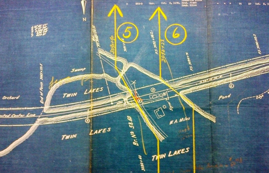
TWIN LAKES1 [CW, 1871; depot 1872]
According to Dick Paddock in one of his Lakeville Journal articles, the creation of this flag stop was due to Frederick Miles whose 'contract' with the railroad was affirmed by his son William in 1923 when the NYNH&H was cutting back service. At that time it was noted that Salisbury land records mention a 'flag station' as part of an arbitrated compensation for Miles's land in 1870 and the CW stock subscription book shows 50 shares purchased by Miles in December of 1868 "on the express condition that a flag station for passengers be maintained on my farm in Salisbury." It is assumed that Miles, by having a stop on his property, intended to profit from the tourism that the railroad was expected to bring or possibly in some other commercial way. Miles, farmer, grocer, owner of the Copake Iron Works and U.S. congressman was no stranger to business or politics. The railroad was apparently in agreement on the business potential even here in such a remote place. An article in the Winsted Herald in October, 1872 said that the CW had "erected at the Twin Lakes station, a much larger and finer depot than was generally supposed would be put there." While the NY&NE's 1880 appraisal of CW assets put the value of this structure at a mere $250 plus $350 for the adjacent picnic pavilion, the investment was sufficient and tourists did come. The allure of the CW's scenic route brought the Hartford Camera Club for one of their Memorial Day excursions on 5/30/1892. Riders snapped views at Satan's Kingdom along the way and were entertained at the lake cottage of R.S. Delamater, noted Hartford photographer. TWIN LAKES1 burned on 6/18/1901, sparks from the 10:37 a.m. train thought to have ignited the roof and resulting in total destruction. Few photos of TWIN LAKES1 are to be found. The shot at [1] shows a credit to H. Miles, likely a relation to the 'landlord,' and a timely date of 1900, just a year before the fire. This depot had neither a canopy nor an agent's bay, as seen in both [1] and [2]. The image at [3] is from the CW Index Map book and shows the planned location amidst the 'twin' lakes, Washining and Washinee. The view at [4] shows the locomotive State Line, flanked by locals, ca. 1871 on the trestle. The westward shot at [5] shows the depot on the north side of the track midway through the lakes. The photo at [6] shows locomotive no. 7, likely PR&NE in the 1890s, traversing the wooded environs of the area. The image at [7] is a stereocard view of the west trestle; both wooden structures were largely filled later in but still prone to occasional sinkage and fires. [REFS: HDC/12/21/1871/02; CWN/08/02/1872/02; WH/10/25/1872/03; DC/10/16/1874/02; NYNE/CW1880; HC/05/31/1892/05; CWN/06/20/1901/03; LJ/06/22/1901/05; LJ/11/19/2009/00; A36; D44; N3.91; Richard Paddock, Rail Tales, p86-89][rev052317]
According to Dick Paddock in one of his Lakeville Journal articles, the creation of this flag stop was due to Frederick Miles whose 'contract' with the railroad was affirmed by his son William in 1923 when the NYNH&H was cutting back service. At that time it was noted that Salisbury land records mention a 'flag station' as part of an arbitrated compensation for Miles's land in 1870 and the CW stock subscription book shows 50 shares purchased by Miles in December of 1868 "on the express condition that a flag station for passengers be maintained on my farm in Salisbury." It is assumed that Miles, by having a stop on his property, intended to profit from the tourism that the railroad was expected to bring or possibly in some other commercial way. Miles, farmer, grocer, owner of the Copake Iron Works and U.S. congressman was no stranger to business or politics. The railroad was apparently in agreement on the business potential even here in such a remote place. An article in the Winsted Herald in October, 1872 said that the CW had "erected at the Twin Lakes station, a much larger and finer depot than was generally supposed would be put there." While the NY&NE's 1880 appraisal of CW assets put the value of this structure at a mere $250 plus $350 for the adjacent picnic pavilion, the investment was sufficient and tourists did come. The allure of the CW's scenic route brought the Hartford Camera Club for one of their Memorial Day excursions on 5/30/1892. Riders snapped views at Satan's Kingdom along the way and were entertained at the lake cottage of R.S. Delamater, noted Hartford photographer. TWIN LAKES1 burned on 6/18/1901, sparks from the 10:37 a.m. train thought to have ignited the roof and resulting in total destruction. Few photos of TWIN LAKES1 are to be found. The shot at [1] shows a credit to H. Miles, likely a relation to the 'landlord,' and a timely date of 1900, just a year before the fire. This depot had neither a canopy nor an agent's bay, as seen in both [1] and [2]. The image at [3] is from the CW Index Map book and shows the planned location amidst the 'twin' lakes, Washining and Washinee. The view at [4] shows the locomotive State Line, flanked by locals, ca. 1871 on the trestle. The westward shot at [5] shows the depot on the north side of the track midway through the lakes. The photo at [6] shows locomotive no. 7, likely PR&NE in the 1890s, traversing the wooded environs of the area. The image at [7] is a stereocard view of the west trestle; both wooden structures were largely filled later in but still prone to occasional sinkage and fires. [REFS: HDC/12/21/1871/02; CWN/08/02/1872/02; WH/10/25/1872/03; DC/10/16/1874/02; NYNE/CW1880; HC/05/31/1892/05; CWN/06/20/1901/03; LJ/06/22/1901/05; LJ/11/19/2009/00; A36; D44; N3.91; Richard Paddock, Rail Tales, p86-89][rev052317]
|
|

|
Max Miller Collection
|
National Archives
|

|
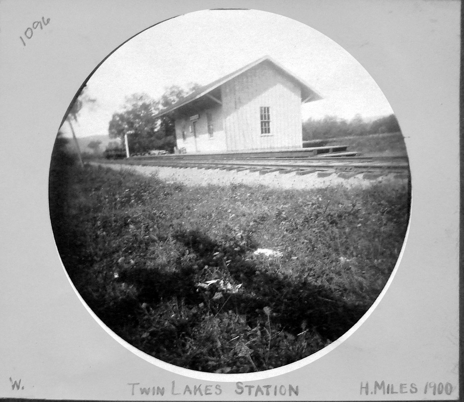
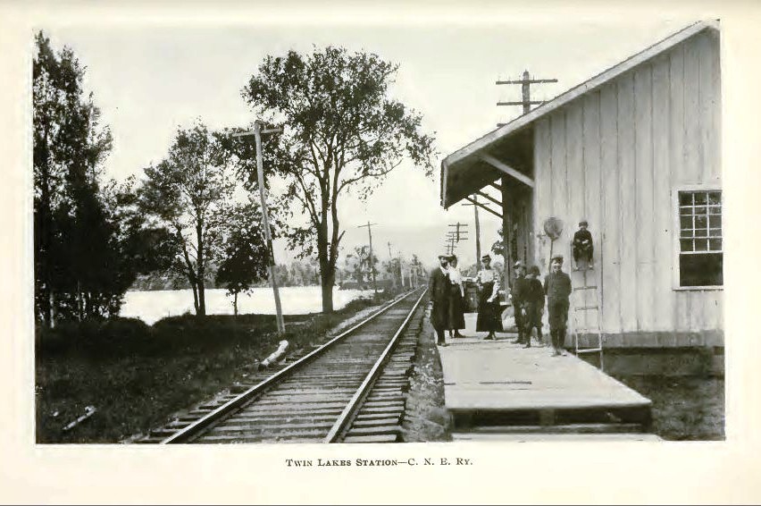
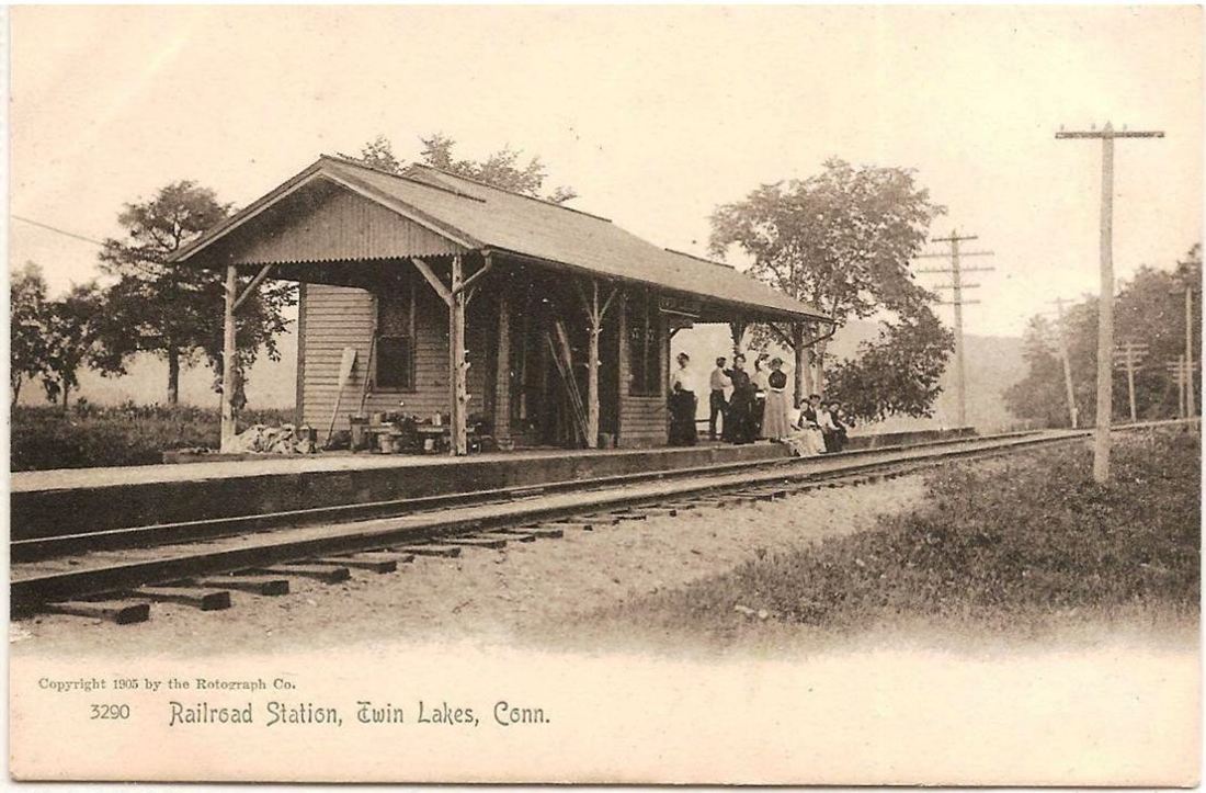
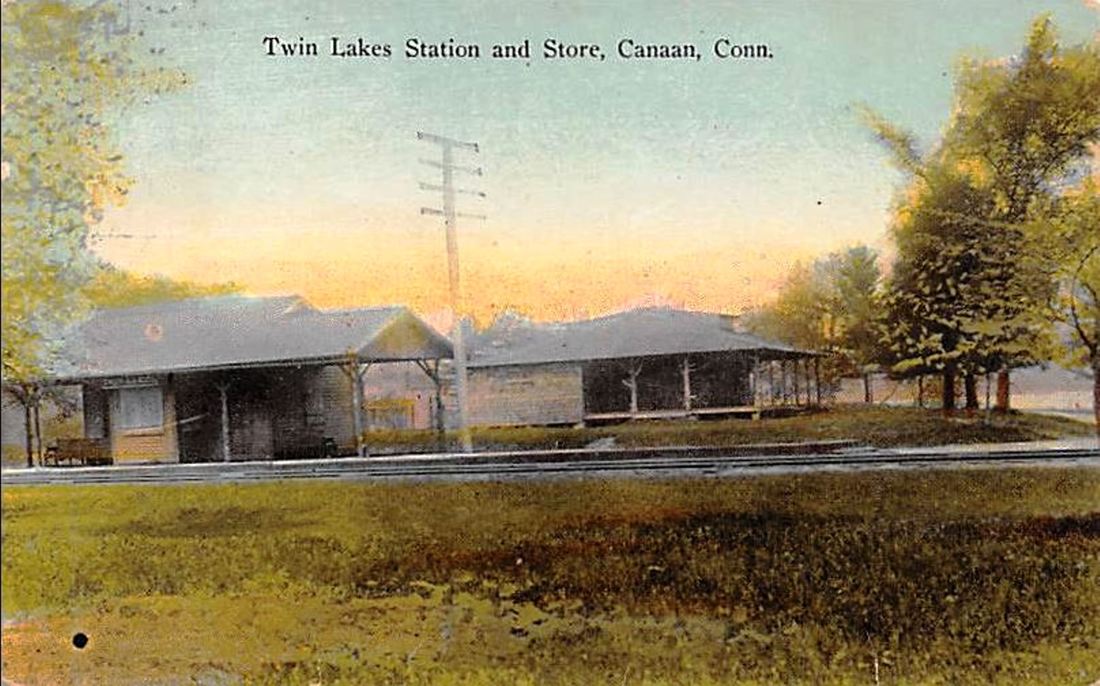
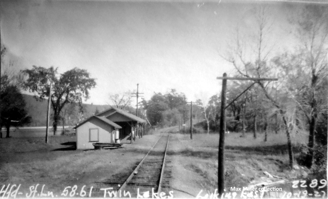
TWIN LAKES2 [CNE, 1901]
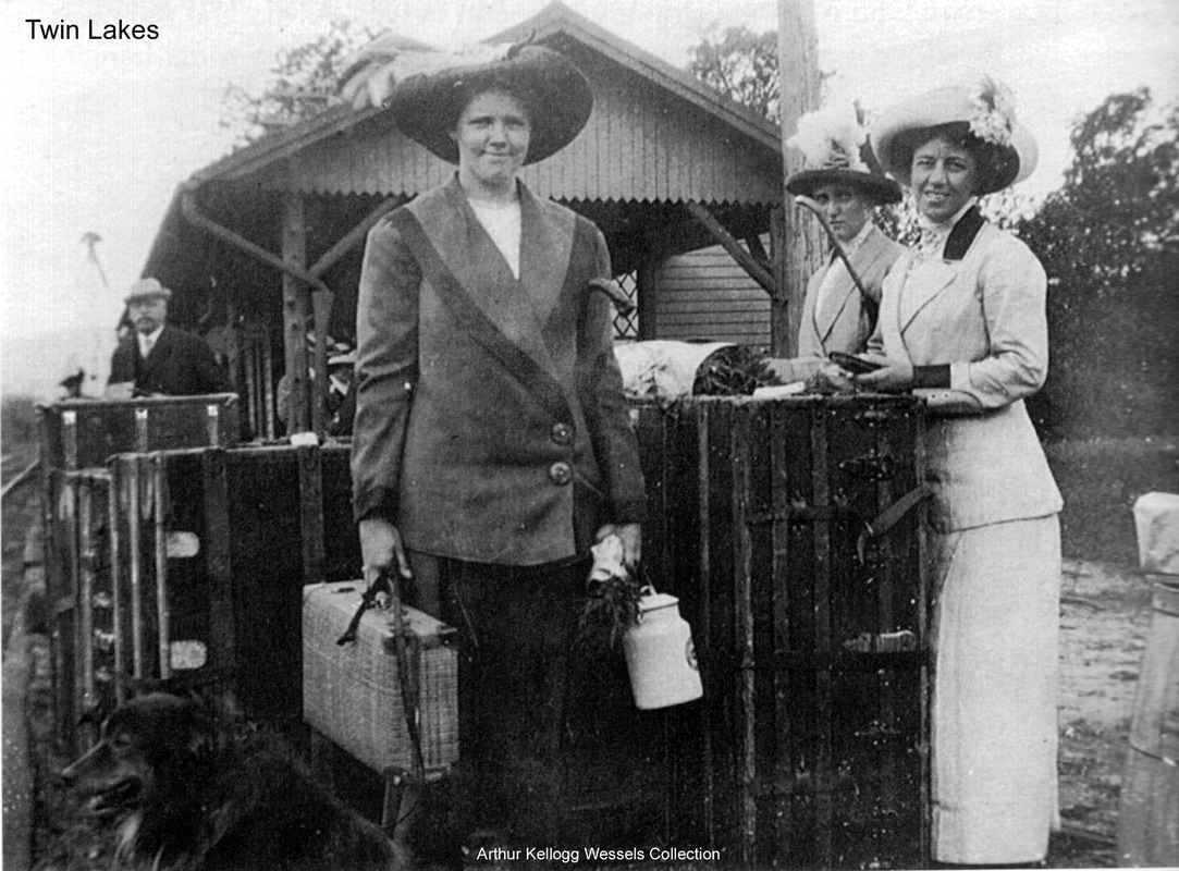
Work began on 7/16/1901 to build TWIN LAKES2. It was completed by 10/31/1901 and subsequently mentioned in the state railroad commission report in December of the year. One copy of the view on the postcard at [1] carries an incorrect date of 1905. Note the fancy diamond-paned windows which starkly contrast with the unfinished tree limbs, branch stubs and all, supporting the covershed! This latter feature would carry over to the bungalow-style store building seen in the postcard at [2]. A seasonal post office was established in this rustic structure in 1909 on the petition of the Twin Lakes Association and lasted until 1942. The shot at [3] shows a westbound train on the causeway, pulling into TWIN LAKES2. The 10/19/1927 PUC shot at [4] looks east, with a section house ahead of the depot and ties piled up as a bumper at the end of the house track. The edited, later copy of the 1916 val map at [5] shows the layout of the grounds and property then owned by W. A. Miles, Frederick's son. The stop signal shown on the map is not seen in the PUC photo, likely due to the end of passenger service in 1927. Lewis H. Benton photo #2665 at [6], taken in June, 1930, shows a rather desolate scene, with station roof intact but sagging. In its early 1900s heyday, this flag stop saw much summer traffic. Margaret and Antoinette Kellogg of Philadelphia are seen in [7] arriving for a stay. In perhaps the most phantasmagorical piece that ever appeared in the Connecticut Western News, a 1906 article recorded the vision of a clairvoyant who foresaw the NYNH&H getting control of all the lake property and by 1911 creating an Electric Park, with amusement rides, trolley service from surrounding points and staged train wrecks between "freight locomotives that have outlived their usefulness... caused to crash together, under a full head of steam, on a track specially built for this purpose." Though the NYNH&H was then gobbling up everything in sight and such rail-crash spectacles took place elsewhere, nothing like this was in the cards here. So opposed to any change were locals who opposed a steam tourist train on the line from Lakeville to Canaan when that segment was up for abandonment in the 1960s. The president of the Twin Lakes Association, Atty. Catherine G. Roraback, and her counterpart at The Salisbury Association, Abbot K. Hamilton, maintained that the new Connecticut Western Railroad Co. would violate zoning ordinances "because of its entertainment nature," would create problems of "dirt and noise" (though oil was to be burned, not coal), endanger property values and "become a detriment to one of Connecticut's most beautiful areas." This is a sad, ironic commentary from a community that owed its creation to the coming of the Iron Horse. The last freight train ran in 1965. Nimke has a 1937 photo of TWIN LAKES2. The 1938 SSRR list says that it was rented as the post office at that time. Its fate thereafter is yet unknown to us. [REFS: CWN/07/18/1901/03; CWN/07/19/1906/01 (pt1); CWN/07/26/1906/01 (pt2); LJ/07/20/1901/01; CRC49.1901.23; HC/04/24/1963/23B; A36; D45; N3.91][rev010518, 042823]
Work began on 7/16/1901 to build TWIN LAKES2. It was completed by 10/31/1901 and subsequently mentioned in the state railroad commission report in December of the year. One copy of the view on the postcard at [1] carries an incorrect date of 1905. Note the fancy diamond-paned windows which starkly contrast with the unfinished tree limbs, branch stubs and all, supporting the covershed! This latter feature would carry over to the bungalow-style store building seen in the postcard at [2]. A seasonal post office was established in this rustic structure in 1909 on the petition of the Twin Lakes Association and lasted until 1942. The shot at [3] shows a westbound train on the causeway, pulling into TWIN LAKES2. The 10/19/1927 PUC shot at [4] looks east, with a section house ahead of the depot and ties piled up as a bumper at the end of the house track. The edited, later copy of the 1916 val map at [5] shows the layout of the grounds and property then owned by W. A. Miles, Frederick's son. The stop signal shown on the map is not seen in the PUC photo, likely due to the end of passenger service in 1927. Lewis H. Benton photo #2665 at [6], taken in June, 1930, shows a rather desolate scene, with station roof intact but sagging. In its early 1900s heyday, this flag stop saw much summer traffic. Margaret and Antoinette Kellogg of Philadelphia are seen in [7] arriving for a stay. In perhaps the most phantasmagorical piece that ever appeared in the Connecticut Western News, a 1906 article recorded the vision of a clairvoyant who foresaw the NYNH&H getting control of all the lake property and by 1911 creating an Electric Park, with amusement rides, trolley service from surrounding points and staged train wrecks between "freight locomotives that have outlived their usefulness... caused to crash together, under a full head of steam, on a track specially built for this purpose." Though the NYNH&H was then gobbling up everything in sight and such rail-crash spectacles took place elsewhere, nothing like this was in the cards here. So opposed to any change were locals who opposed a steam tourist train on the line from Lakeville to Canaan when that segment was up for abandonment in the 1960s. The president of the Twin Lakes Association, Atty. Catherine G. Roraback, and her counterpart at The Salisbury Association, Abbot K. Hamilton, maintained that the new Connecticut Western Railroad Co. would violate zoning ordinances "because of its entertainment nature," would create problems of "dirt and noise" (though oil was to be burned, not coal), endanger property values and "become a detriment to one of Connecticut's most beautiful areas." This is a sad, ironic commentary from a community that owed its creation to the coming of the Iron Horse. The last freight train ran in 1965. Nimke has a 1937 photo of TWIN LAKES2. The 1938 SSRR list says that it was rented as the post office at that time. Its fate thereafter is yet unknown to us. [REFS: CWN/07/18/1901/03; CWN/07/19/1906/01 (pt1); CWN/07/26/1906/01 (pt2); LJ/07/20/1901/01; CRC49.1901.23; HC/04/24/1963/23B; A36; D45; N3.91][rev010518, 042823]
Orange Historical Society
|

|
|
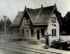
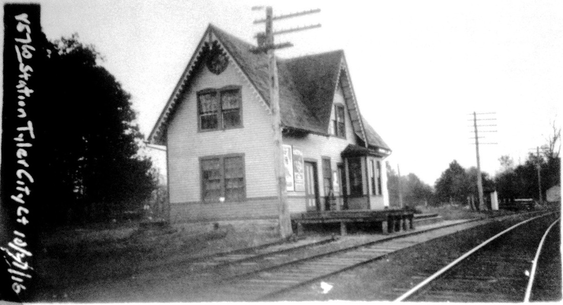
TYLER CITY [NH&D, 1872]
This website's namesake station was built in the town of Orange in 1872 and presented to the NH&D on condition that trains always stop there. They did until 1925 when passenger service ended, with freight shipments probably continuing until 1937. The structure was burned by Fourth of July "celebrants" at 4:00 A.M. on the morning of 7/5/1936. See Track 1 for more.
This website's namesake station was built in the town of Orange in 1872 and presented to the NH&D on condition that trains always stop there. They did until 1925 when passenger service ended, with freight shipments probably continuing until 1937. The structure was burned by Fourth of July "celebrants" at 4:00 A.M. on the morning of 7/5/1936. See Track 1 for more.

|
|

|
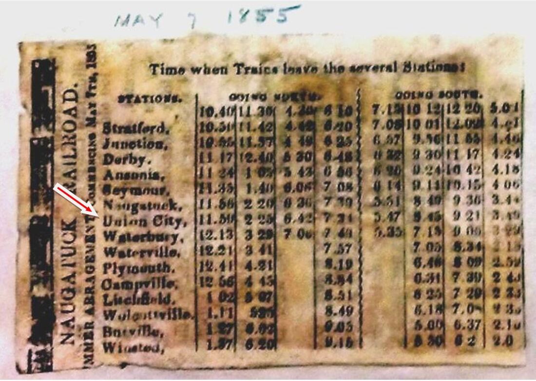
UNION CITY/N1 [NRR, 1855]
There was no railroad stop here in the town of NAUGATUCK between 1849 when the NRR opened and a January, 1855 timetable we have, but by May, 1855, the image at [4] lists the station. This manufacturing district in the town of Naugatuck is first spoken of in the Courant in 1856. In 1858 John Howard Whittemore and Bronson Beecher Tuttle teamed up to build a foundry for the production of malleable iron products that were far superior to their older cast iron counterparts [click here]. Their successful venture would eventually employ much of the area labor force at a location that was undoubtedly chosen for its adjacency to the railroad, thereby creating the need for a station. This 'city' was north of the central borough and the name also applied to some of the area east of the Naugatuck River, as it still does today. The 1877 Bailey bird's-eye map of Naugatuck at [1] and enlargement at [2] does not identify a station per se, but shows a structure that corresponds to the 1868 map at [3]. The name of the locale seems to derive from the reverence for the U. S. federal union of states, possibly in anticipation of the coming Civil War, and appears in many geographic names of the era. J.H. Whittemore would become a NYNH&H director and a generous benefactor to the borough of Naugatuck where the public library is named for one of his sons. It was through the industrialist's influence that the NAUGATUCK3 station came to fruition. Tuttle and Whittemore Iron Works was reorganized many times and survives today as the Eastern Company [click here] but is no longer headquartered in the Union City section of Naugatuck. [REFS: HDC/01/26/1856/02; C92][rev030513, 061922, 042923]
There was no railroad stop here in the town of NAUGATUCK between 1849 when the NRR opened and a January, 1855 timetable we have, but by May, 1855, the image at [4] lists the station. This manufacturing district in the town of Naugatuck is first spoken of in the Courant in 1856. In 1858 John Howard Whittemore and Bronson Beecher Tuttle teamed up to build a foundry for the production of malleable iron products that were far superior to their older cast iron counterparts [click here]. Their successful venture would eventually employ much of the area labor force at a location that was undoubtedly chosen for its adjacency to the railroad, thereby creating the need for a station. This 'city' was north of the central borough and the name also applied to some of the area east of the Naugatuck River, as it still does today. The 1877 Bailey bird's-eye map of Naugatuck at [1] and enlargement at [2] does not identify a station per se, but shows a structure that corresponds to the 1868 map at [3]. The name of the locale seems to derive from the reverence for the U. S. federal union of states, possibly in anticipation of the coming Civil War, and appears in many geographic names of the era. J.H. Whittemore would become a NYNH&H director and a generous benefactor to the borough of Naugatuck where the public library is named for one of his sons. It was through the industrialist's influence that the NAUGATUCK3 station came to fruition. Tuttle and Whittemore Iron Works was reorganized many times and survives today as the Eastern Company [click here] but is no longer headquartered in the Union City section of Naugatuck. [REFS: HDC/01/26/1856/02; C92][rev030513, 061922, 042923]

|

|
UNION CITY/N2 [NRR, 1880s]
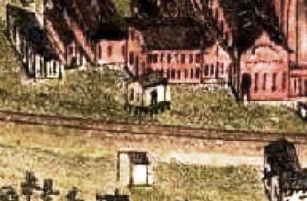
Not on the Bailey 1877 map, we speculate that the second station was put up in the 1880s and is seen in this snip from the 1906 Hughes & Bailey map. With small gables on each of the four sides of the hipped roof, this station may also reflect the Whittemore munificence. It appears we have been fortunate once again to have Bailey back in town in 1906, just prior to the building of the next station here in 1907, so we have this unique image preserved. We hope at some point to find a photograph that would provide corroboration. The fate of this station is unknown but it may have fallen with the double-tracking project completed by 1908. [REFS: HC/01/20/1908/12][rev061922]
Not on the Bailey 1877 map, we speculate that the second station was put up in the 1880s and is seen in this snip from the 1906 Hughes & Bailey map. With small gables on each of the four sides of the hipped roof, this station may also reflect the Whittemore munificence. It appears we have been fortunate once again to have Bailey back in town in 1906, just prior to the building of the next station here in 1907, so we have this unique image preserved. We hope at some point to find a photograph that would provide corroboration. The fate of this station is unknown but it may have fallen with the double-tracking project completed by 1908. [REFS: HC/01/20/1908/12][rev061922]
|
|
|
|
|

|
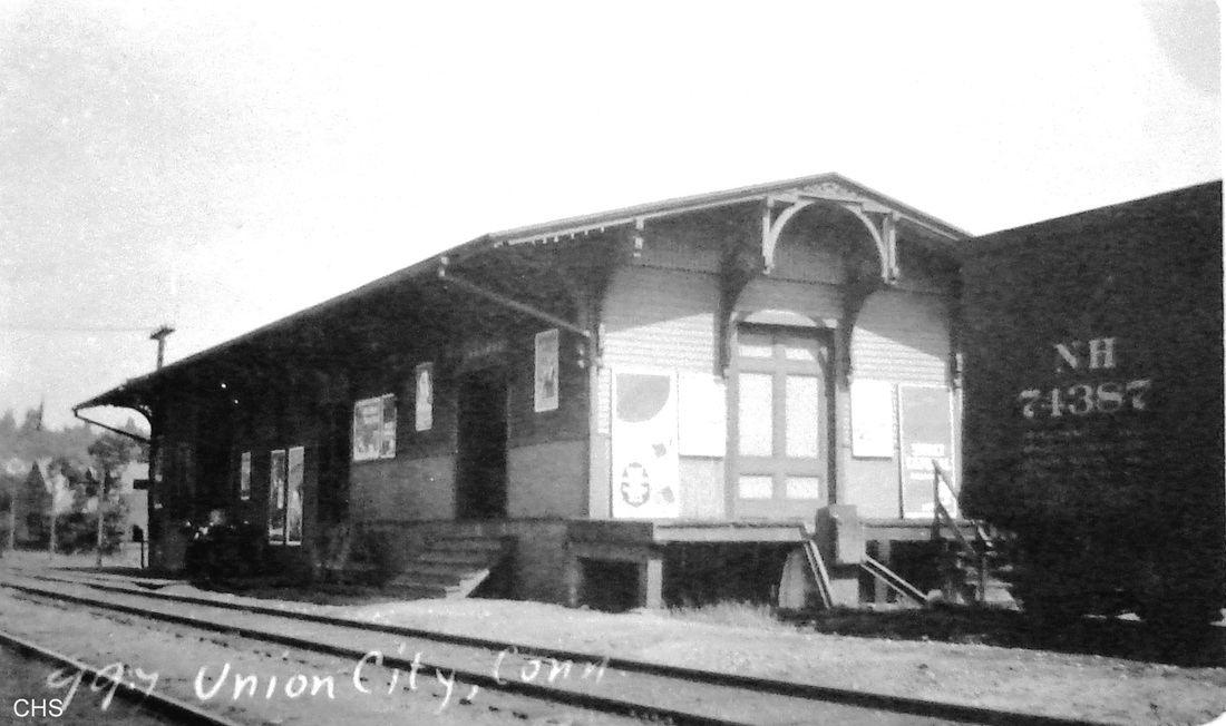
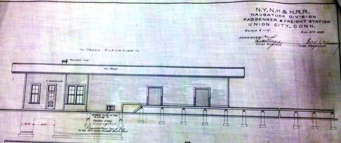
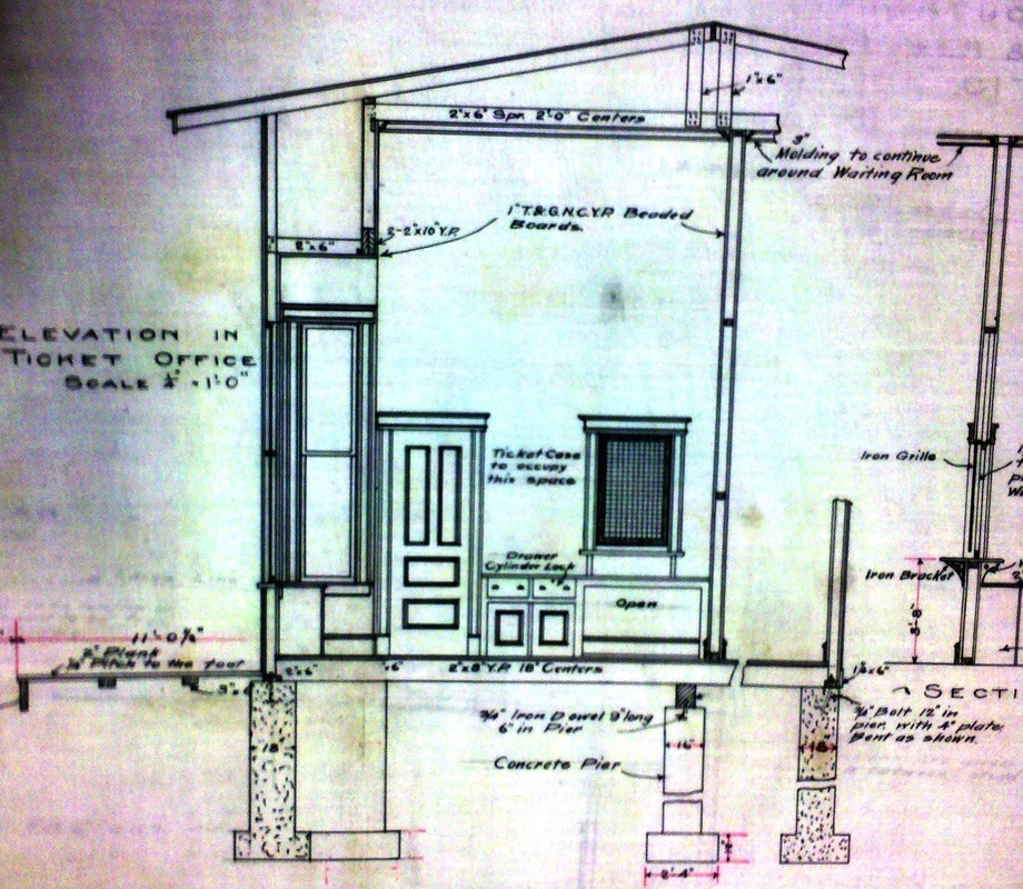
UNION CITY/N3 [NYNH&H, 1907]
The plans for the third station here on the NRR, controlled since April, 1887 by the NYNH&H, are dated 11/9/1906 and construction was probably completed in 1907 in conjunction with the double-tracking. This functional combination station neatly served both the passenger and freight needs of this busy industrial section of Naugatuck. The unusual bracket work on the ends of the structure gave it a distinctive look and is a detail not shown on any of the building plans we have. The val photo at [1] is dated 7/2/1917 and the PUC shot at [2] dates to 4/27/1924, The photo at [3] is Lewis H. Benton's #997 from August, 1917. The 1938 SSRR list shows this station as rented for $300 per year. It was reportedly torn down in the winter of 1968. [REFS: HC/06/03/1907/17][rev010518, 112320, 061922]
The plans for the third station here on the NRR, controlled since April, 1887 by the NYNH&H, are dated 11/9/1906 and construction was probably completed in 1907 in conjunction with the double-tracking. This functional combination station neatly served both the passenger and freight needs of this busy industrial section of Naugatuck. The unusual bracket work on the ends of the structure gave it a distinctive look and is a detail not shown on any of the building plans we have. The val photo at [1] is dated 7/2/1917 and the PUC shot at [2] dates to 4/27/1924, The photo at [3] is Lewis H. Benton's #997 from August, 1917. The 1938 SSRR list shows this station as rented for $300 per year. It was reportedly torn down in the winter of 1968. [REFS: HC/06/03/1907/17][rev010518, 112320, 061922]
|
|
|
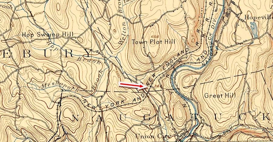
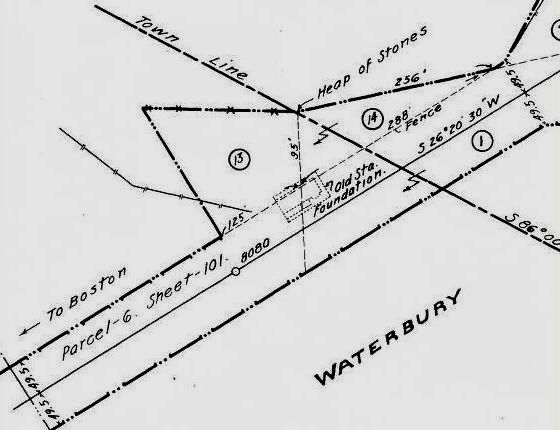
UNION CITY/W [NY&NE, 1881]
We have labeled this entry with the '/W' to distinguish this stop from the NRR line. The image at [1] purportedly is this station and it does looks similar to some of the Leman Oatman stations, e.g. TOWANTIC, elsewhere along the NY&NE's 1881 extension to the Hudson River. There are, however, some interesting differences like the eyelet roof feature which is unseen elsewhere and what looks to be a separate freight house behind the passenger station. Also contraindicating the image is the 1915 val map at [2] that shows a footprint more akin to combination stations like SOUTHFORD at [3]. This stop was also known as HOP BROOK and there was almost an immediate call for it to be moved to Bradleyville Rd., today's Rte. 63, on the west side of the ravine. A newspaper article said that the move would have made the station more accessible to Naugatuck and surrounding towns and would have made the building of a road, today's Spring St., up from Union City proper unnecessary. Our red arrow on the 1892 topo map shows the location. At the elevation of the stone arch over over Rte. 63, as seen below, it would not have been easy to make a station accessible at that level, which was perhaps the reason that the railroad commissioners denied the request. The area north and east of this station would later be the home of the Bristol Co. complex. That extensive property stretched to the river and the NRR line, which served it from the PLATTS MILL stop. Curiously and coincidentally, another potential union was in the offing at Union City when an 1887 Register article said that a projected extension of the NH&D was going to meet the NY&NE here to provide a parallel freight route for the Naugatuck Valley and competing passenger service to Boston. That project never came to fruition but the substantial size of this off-the-beaten path station may reflect the grander intentions never realized here. Abandonment of this station as well as BRADLEYS in Middlebury was permitted by special act of the state legislature in 1899 in return for the creation of a new OSBORNTOWN stop, shortly thereafter renamed ALLERTON FARMS. This timing coincided with the final bow of the NY&NE which completely disappeared into the NYNH&H in 1898. A 1901 Courant article mentions a robbery at this station which was apparently still open then and exactly when it closed thereafter is unclear. [REFS: NHER/05/14/1881/01; NHER/08/03/1881/04; CRC30.1883.35; NHER/12/31/1887/01; HC/11/05/1898/10; 1899 Conn. Spec. Act 405; HC/11/28/1901/01; C306; RAM??][rev040116, 112320]
We have labeled this entry with the '/W' to distinguish this stop from the NRR line. The image at [1] purportedly is this station and it does looks similar to some of the Leman Oatman stations, e.g. TOWANTIC, elsewhere along the NY&NE's 1881 extension to the Hudson River. There are, however, some interesting differences like the eyelet roof feature which is unseen elsewhere and what looks to be a separate freight house behind the passenger station. Also contraindicating the image is the 1915 val map at [2] that shows a footprint more akin to combination stations like SOUTHFORD at [3]. This stop was also known as HOP BROOK and there was almost an immediate call for it to be moved to Bradleyville Rd., today's Rte. 63, on the west side of the ravine. A newspaper article said that the move would have made the station more accessible to Naugatuck and surrounding towns and would have made the building of a road, today's Spring St., up from Union City proper unnecessary. Our red arrow on the 1892 topo map shows the location. At the elevation of the stone arch over over Rte. 63, as seen below, it would not have been easy to make a station accessible at that level, which was perhaps the reason that the railroad commissioners denied the request. The area north and east of this station would later be the home of the Bristol Co. complex. That extensive property stretched to the river and the NRR line, which served it from the PLATTS MILL stop. Curiously and coincidentally, another potential union was in the offing at Union City when an 1887 Register article said that a projected extension of the NH&D was going to meet the NY&NE here to provide a parallel freight route for the Naugatuck Valley and competing passenger service to Boston. That project never came to fruition but the substantial size of this off-the-beaten path station may reflect the grander intentions never realized here. Abandonment of this station as well as BRADLEYS in Middlebury was permitted by special act of the state legislature in 1899 in return for the creation of a new OSBORNTOWN stop, shortly thereafter renamed ALLERTON FARMS. This timing coincided with the final bow of the NY&NE which completely disappeared into the NYNH&H in 1898. A 1901 Courant article mentions a robbery at this station which was apparently still open then and exactly when it closed thereafter is unclear. [REFS: NHER/05/14/1881/01; NHER/08/03/1881/04; CRC30.1883.35; NHER/12/31/1887/01; HC/11/05/1898/10; 1899 Conn. Spec. Act 405; HC/11/28/1901/01; C306; RAM??][rev040116, 112320]
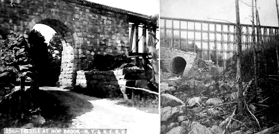
The engineering feat known as the Hop Brook trestle stood just west of the NY&NE's UNION CITY station. The composite image shows what the entire structure looked like, though the culvert for the brook is about 50 feet below the road level shown here. The beautiful stone culvert is approximately 250 feet long, 20 feet tall and almost as wide. It reportedly had been built by the BH&E in 1869 "at an enormous expense," at which time a Courant item commented that "the embankment now building at Hop Brook, near Waterbury, is the highest of any on the line of the Boston, Hartford and Erie railroad, and the whole work on the line between Waterbury and Southford is the hardest on the road." It would remain unused until 1881 when the trestle, stretching 300 feet across the ravine and 90 feet in the air, was completed for the opening of the NY&NE west to the Hudson River. The Georgia pine wooden latticework was filled in 1897. The arch over the roadway stood 25 feet tall but, only 16.5 feet wide at the base and it necessitated one-way vehicular traffic that became increasingly dangerous. The 'New England Arch' was taken down in 1940, shortly after the NY&NE line from Waterbury to Southbury was abandoned in 1937. The culvert over the brook is, thankfully, still intact today just south of the Hop Brook Dam. [REFS: HDC/07/30/1868/02; HC/09/22/1868/04; HDC/08/12/1869/04; BJ/08/11/1880/04; DN/07/27/1881/01; CRC45.1897.23; K84; NL20.3.11][rev040116]
UNION VILLAGE [> MANCHESTER1]
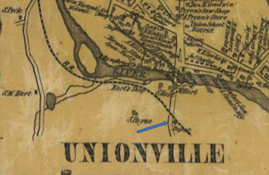
|
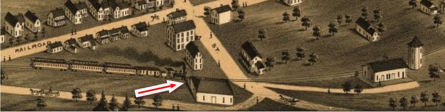
|
UNIONVILLE1 [NH&H, 1850]
The NH&N opened the Collinsville branch and established a stop for this village in the town of Farmington in 1850. The location is shown to be east of Bridge St. on the 1855HC map at left. The 1878 Bailey bird's-eye map image at right shows a train heading east past the freight depot at the red arrow and about to stop at UNIONVILLE2. With early railroads known for recycling structures, we wondered if the freight station had not served as UNIONVILLE1 earlier and was possibly moved across the street when the second station was built. No actual photo of the first station here has yet been found and its fate is otherwise unknown. It is likely among the "old and inconvenient passenger depot buildings" that the railroad commissioners said in their 1875 annual report had been replaced by the NH&N. [REFS: RF/09/04/1849/02]
The NH&N opened the Collinsville branch and established a stop for this village in the town of Farmington in 1850. The location is shown to be east of Bridge St. on the 1855HC map at left. The 1878 Bailey bird's-eye map image at right shows a train heading east past the freight depot at the red arrow and about to stop at UNIONVILLE2. With early railroads known for recycling structures, we wondered if the freight station had not served as UNIONVILLE1 earlier and was possibly moved across the street when the second station was built. No actual photo of the first station here has yet been found and its fate is otherwise unknown. It is likely among the "old and inconvenient passenger depot buildings" that the railroad commissioners said in their 1875 annual report had been replaced by the NH&N. [REFS: RF/09/04/1849/02]
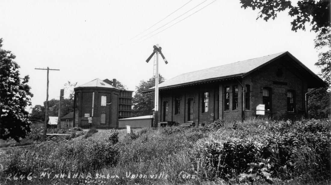
|

Dave Peters Collection
|
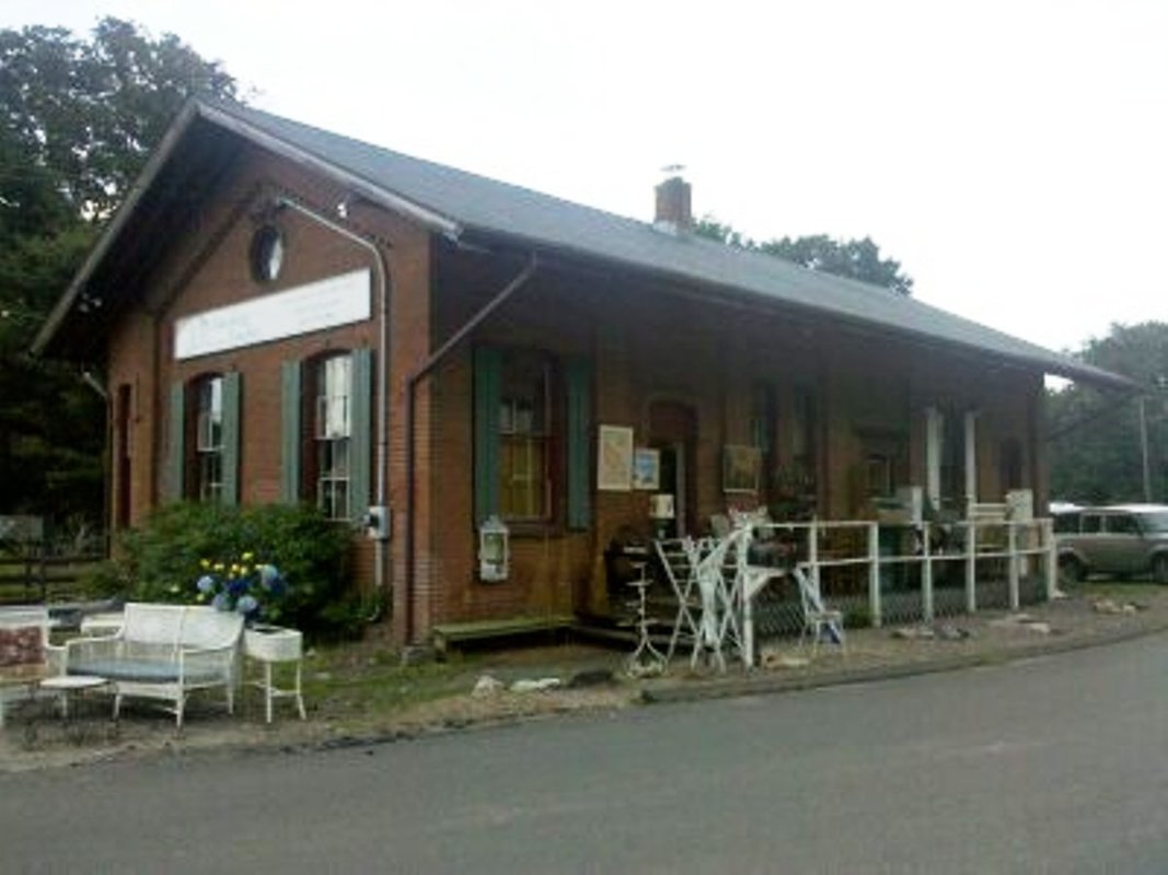
|
UNIONVILLE2 [NH&N, 1875]
This depot is mentioned in both the railroad commissioners annual report issued in May, 1876 and the NH&N's report to the stockholders in January, 1876. It would appear to have been built between May and December, 1875, leaning toward later in the year. The photo at [1] is Lewis H. Benton's from June, 1930. The ICC vakuation shot at [2] is dated 9/26/1916. The 2010 photo at right shows this station, which had a full basement, as an antiques and collectibles shop at that time. It is still extant today in 2023. The 1938 SSRR retained list shows this as being retired but kept for railroad service. [REFS: CRC22.1875.6; CR/01/01/1876/02; CRC23.1876.17; D114+; R100][rev010518, 042823]
This depot is mentioned in both the railroad commissioners annual report issued in May, 1876 and the NH&N's report to the stockholders in January, 1876. It would appear to have been built between May and December, 1875, leaning toward later in the year. The photo at [1] is Lewis H. Benton's from June, 1930. The ICC vakuation shot at [2] is dated 9/26/1916. The 2010 photo at right shows this station, which had a full basement, as an antiques and collectibles shop at that time. It is still extant today in 2023. The 1938 SSRR retained list shows this as being retired but kept for railroad service. [REFS: CRC22.1875.6; CR/01/01/1876/02; CRC23.1876.17; D114+; R100][rev010518, 042823]

Gunn Memrial Library and Museum
|
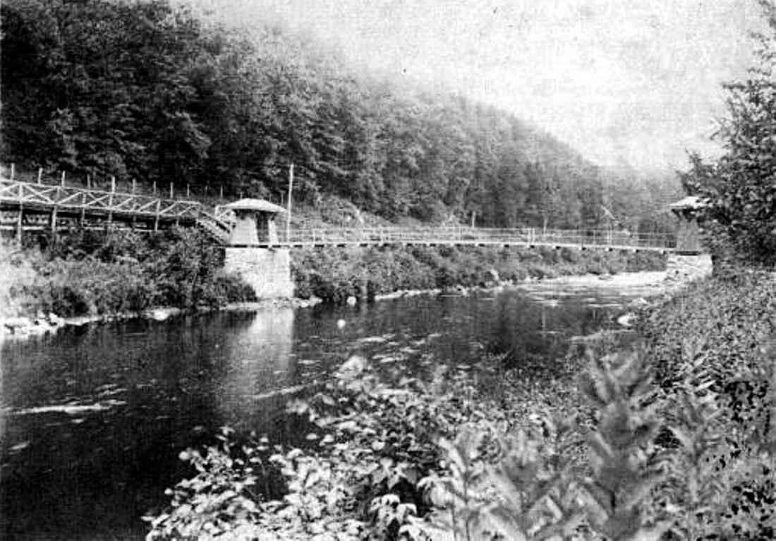
Estella West Collection
|

|
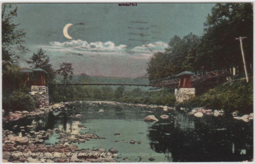
|
|

|
VALLEY STATION [SRR, 1879?; first depot 1893?]
This flag stop was in the town of Washington in today's Steep Rock Preserve that also contains the Shepaug Tunnel which we deal with at JUDDS BRIDGE. An interesting August, 1879 news article says that a Shepaug train last week "... had on board a strange party, consisting of 80 small children from three to twelve years of age... neatly and plainly dressed... from the various charitable institutions in New York City, and were sent by the New York Evening Post Fresh Air Fund. Their destination was Washington where they will remain two weeks. A matron accompanied them." The ubiquitous Bee sheds further light, saying in 1893 that... "The new depot on the Shepaug, a mile below Washington, where the children for the Vacation home leave the cars, has been named Valley Station. The small station building has been painted and the grounds nicely graded. It is presumably the work of Mr. Van Ingen. He and many of the city sojourners here take the train and leave it at this depot. There is a town bridge across the Shepaug at this point..." So we have to assume that trains were stopping here at least from 1879, though this station is not on an 1884 timetable. Unless we are missing it, the 'small station building' is not apparent in the few historical photos we have. They only show the suspension bridge and a platform, which is what most claim is all that ever stood here. The bridge from the trackside platform on the west bank of the Shepaug leads directly to a gateway road to the mansion up on the hill, the summer home of wealthy New York City wool importer Edward Hook Van Ingen. In 1893, he was building Holiday House on his property to accommodate visitors and came back from Europe in late June "to oversee the opening of the Vacation house which is now ready for the reception of guests." E.H. was roundly eulogized upon his death in 1920 as philanthropist and benefactor to the town. We speculate the following: the 1879 kids stayed somewhere in Washington, perhaps here on the property E.H. bought in 1881 and on which he later constructed the Holiday House in 1893, building the platform and suspension bridge at the same time. Coincidentally, a 1902 news article rumors that a suspension is to be built here to replace one submerged "that has done duty for the last eight years." Is it the new or the old one we see in the pix? A research trip to the Gunn Memorial Library and Museum, which Van Ingen funded and donated to the town, may answer any outstanding questions in this mystery mosaic. Regarding the the Fresh Air Fund movement, it was begun in many cities by businesses, churches and charities in 1877 to bring urban children and working moms out for vacations. Destinations from NYC were all over the Northeast and the railroads provided special cars to facilitate the trips. Litchfield and Washington, CT may have been among the first towns to offer this kind of hospitality.
IMAGES: [1] Northeastward view, platform on the west side of river; [2] northwestward view [3] card postmarked 8/19/19 looks southward, beautiful crescent moon shines on the bridge; [4] 6/30/1915 val map shows Valley Bridge Station, footbridge; [5] later historical photo with suspension bridge removed; [6] replicates [5]. Enlarge to see western abutment, the eastern still standing out of sight to the right. [7] Track 12 Google Earth map snippet. REFERENCES: CWN/08/06/1879/02; NBE/03/31/1881/03; NBE/03/24/1893/08; NBE/06/30/1893/07; NBE/07/28/1893/09; NBE/10/24/1902/09; Brady unpaged typescript; Cooper, p12, says stop came in 1893; TCS REVISIONS: 7/01/2015, 6/24/2022, 042923]
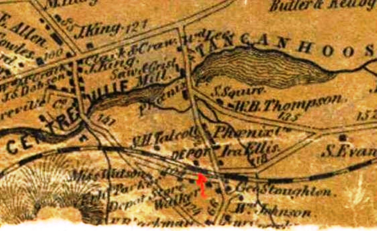
VERNON1 [HP&F, 1849]
Though the community here is called Centreville on the 1857TC map, Tancanhoosen (sic) Lake identifies this location as the stop on the HP&F that was known as VERNON from the opening of the railroad. A newspaper article from the Courant said the freight depot here burned on 6/29/1855 but the Boston Press and Post said that it was the passenger and freight depots. Inasmuch as the early HP&F stations were probably combination affairs, both papers may be correct. No news coverage of the rebuilding has been found but it is assumed that it took place later in the year. [REFS: 1851TT; HPFAR6.1855.8; HDC/06/29/1855/02; BPP/07/02/1855/04]
Though the community here is called Centreville on the 1857TC map, Tancanhoosen (sic) Lake identifies this location as the stop on the HP&F that was known as VERNON from the opening of the railroad. A newspaper article from the Courant said the freight depot here burned on 6/29/1855 but the Boston Press and Post said that it was the passenger and freight depots. Inasmuch as the early HP&F stations were probably combination affairs, both papers may be correct. No news coverage of the rebuilding has been found but it is assumed that it took place later in the year. [REFS: 1851TT; HPFAR6.1855.8; HDC/06/29/1855/02; BPP/07/02/1855/04]
VERNON2 [HP&F, 1855]
This is a bit speculative but the next station looks far too substantial to date back to 1855 when VERNON1 burned, so we think there was an intervening depot before VERNON3 was put up.
This is a bit speculative but the next station looks far too substantial to date back to 1855 when VERNON1 burned, so we think there was an intervening depot before VERNON3 was put up.

|
vernondepot.com
|

|
vernondepot.com
VERNON3 [NYNH&H, c1890?]
The image at [1] is from the 1895 Bailey aero view map of Rockville, Talcottville and Vernon. Click here for the LOC panoramic map collection and look under Connecticut. The snippet seems to show this third station in place by now, with an exact build date undiscovered by us as of yet. The style matches FAIRFIELD2 and MILFORD2 that were built in the 1880s. The shot at [2] dates to 7/13/1934. The undated view at [3] shows an eastbound train with its conductor running ahead on some urgent business. At extreme right is the water tank and the Rockville Branch track. Click here for the informative VernonDepot website with more about this station and locale. It says the railroad closed the station on 12/31/1930 but our 2/8/1932 timetable still shows this as a passenger stop. The 1938 SSRR list says this station has been sold to A. Balchunas for $35.00 on 7/31/1939 The 3/15/1939 SSRR addendum says the passenger and coal house are occupied by the U.S. Geodetic Survey! More research obviously needs to be done here to clarify the build date and possibly the raze date and the events in between. [rev010818, 042823]
The image at [1] is from the 1895 Bailey aero view map of Rockville, Talcottville and Vernon. Click here for the LOC panoramic map collection and look under Connecticut. The snippet seems to show this third station in place by now, with an exact build date undiscovered by us as of yet. The style matches FAIRFIELD2 and MILFORD2 that were built in the 1880s. The shot at [2] dates to 7/13/1934. The undated view at [3] shows an eastbound train with its conductor running ahead on some urgent business. At extreme right is the water tank and the Rockville Branch track. Click here for the informative VernonDepot website with more about this station and locale. It says the railroad closed the station on 12/31/1930 but our 2/8/1932 timetable still shows this as a passenger stop. The 1938 SSRR list says this station has been sold to A. Balchunas for $35.00 on 7/31/1939 The 3/15/1939 SSRR addendum says the passenger and coal house are occupied by the U.S. Geodetic Survey! More research obviously needs to be done here to clarify the build date and possibly the raze date and the events in between. [rev010818, 042823]
Max Miller Collection
|

|
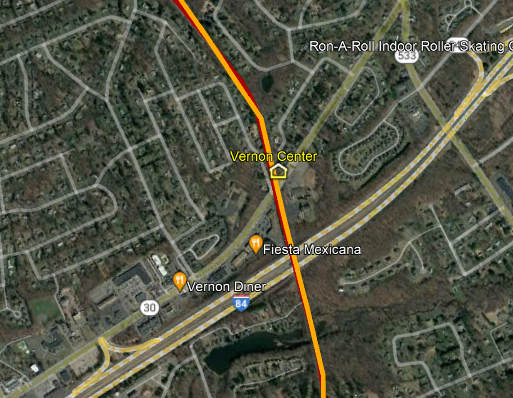
|
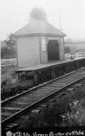
VERNON CENTER [NYNH&H, c1900?]
Station in the town of Vernon on the Rockville Branch about a mile above VERNON. It is seen at [1] in the the 9/25/1923 PUC inspection photo a little left of center. The 6/30/1915 ICC valuation map at [2] shows the location in the northeast quadrant of the grade crossing on today's Rte. 30. This is also shown at [3] on the snippet from our Track 11 Google Earth map. The ICC valuation photo at [4] is dated 8/7/1916. [rev042923]
Station in the town of Vernon on the Rockville Branch about a mile above VERNON. It is seen at [1] in the the 9/25/1923 PUC inspection photo a little left of center. The 6/30/1915 ICC valuation map at [2] shows the location in the northeast quadrant of the grade crossing on today's Rte. 30. This is also shown at [3] on the snippet from our Track 11 Google Earth map. The ICC valuation photo at [4] is dated 8/7/1916. [rev042923]
VERNON JUNCTION [> WEST STREET]
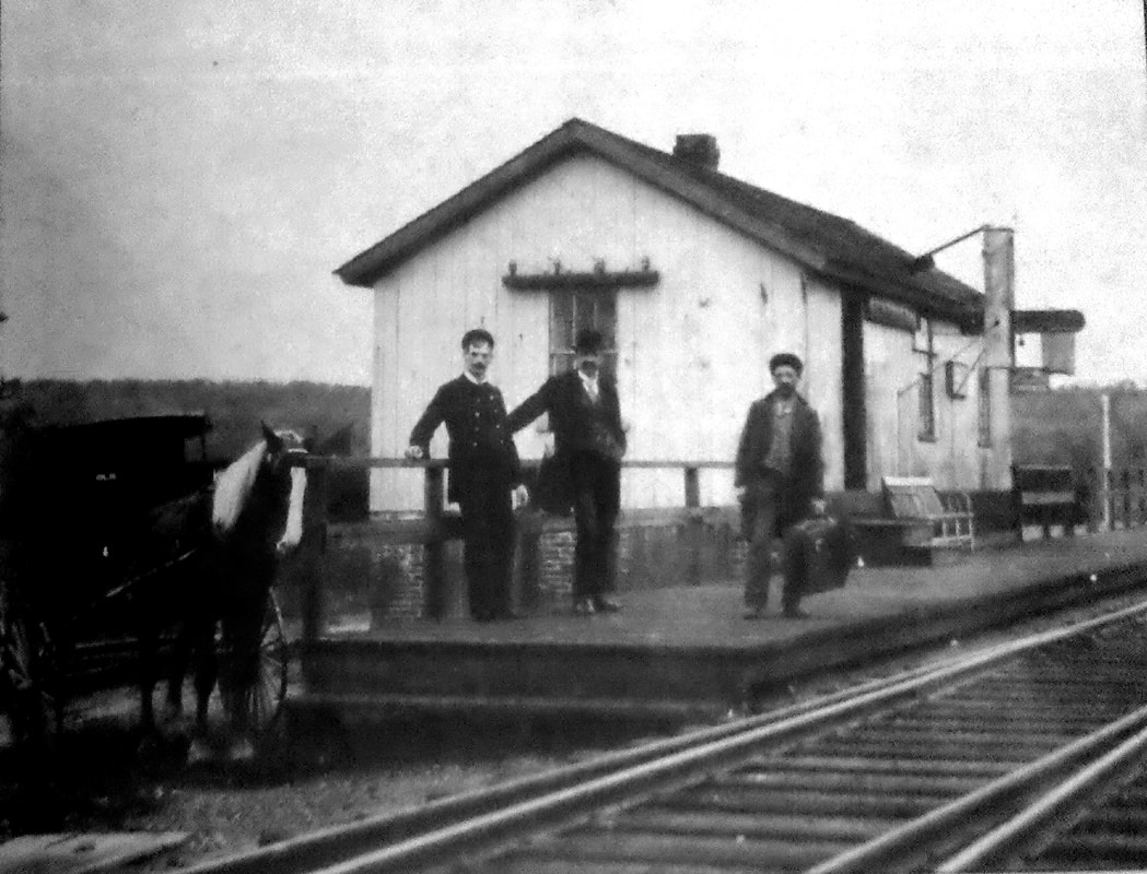
|

|
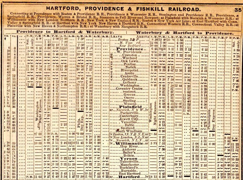
|

VERSAILLES1 [NY&NE, ca. 1872]
This station was in the town of Sprague which was incorporated from Lisbon and Franklin in 1861. The NY&NE annual report of December, 1880 said that a new station had been built in the past year. That may have actually been a replacement for a stop called LOVETTS, one mile west of here, and the first to carry the name VERSAILLES. Coincidentally the last mention we have seen of LOVETTS is on HP&F ETT #102 (9/18/1872). Eastern Connecticut is famed for its mills and this town and village are good examples. The town was named for William S. Sprague of Cranston, RI who began to build the "largest mill on the Western Continent" at BALTIC. in 1856. In 1880 the Sayles woolen mill and the entire village were purchased by L.M. Heery of West Chelmsford, MA with the intention of restarting the mill after nearly a year of suspended operation. We have seen elsewhere, e.g. TURNERVILLE/AMSTON and WAUREGAN, that mills and the surrounding villages were often purchased by entrepreneurs lock, stock and barrel, creating 'company towns' in the process. The photo at [1] looks to be Civil War era based on the style of dress of the young man on the left. The 1868 map at [2] shows several mills along the Little and Shetucket Rivers, some noted for their production of paper. The 1876 timetable at [3] has VERSAILLES but no LOVETTS. The 1892 topo map at [4] shows the exact placement of the VERSAILLES station at our blue arrow. The old LOVETTS location is at the red arrow. Many thanks to Jason at the New Britain Public Library for reference assistance with Connecticut Place Names, a valuable work which delves into the history of location names in the state. The origin of the name here would seem to be the palace at Versailles but CPN only says the village was known as Eagleville "... until the railroad station was named Versailles." Further research is needed to make the connection between this place and the famed French palace. [REFS: HC/03/13/1879/04; HC/01/21/1800/04; NYNEAR5.1880.12; C175; CPN545, 546][rev092121, 042823]
This station was in the town of Sprague which was incorporated from Lisbon and Franklin in 1861. The NY&NE annual report of December, 1880 said that a new station had been built in the past year. That may have actually been a replacement for a stop called LOVETTS, one mile west of here, and the first to carry the name VERSAILLES. Coincidentally the last mention we have seen of LOVETTS is on HP&F ETT #102 (9/18/1872). Eastern Connecticut is famed for its mills and this town and village are good examples. The town was named for William S. Sprague of Cranston, RI who began to build the "largest mill on the Western Continent" at BALTIC. in 1856. In 1880 the Sayles woolen mill and the entire village were purchased by L.M. Heery of West Chelmsford, MA with the intention of restarting the mill after nearly a year of suspended operation. We have seen elsewhere, e.g. TURNERVILLE/AMSTON and WAUREGAN, that mills and the surrounding villages were often purchased by entrepreneurs lock, stock and barrel, creating 'company towns' in the process. The photo at [1] looks to be Civil War era based on the style of dress of the young man on the left. The 1868 map at [2] shows several mills along the Little and Shetucket Rivers, some noted for their production of paper. The 1876 timetable at [3] has VERSAILLES but no LOVETTS. The 1892 topo map at [4] shows the exact placement of the VERSAILLES station at our blue arrow. The old LOVETTS location is at the red arrow. Many thanks to Jason at the New Britain Public Library for reference assistance with Connecticut Place Names, a valuable work which delves into the history of location names in the state. The origin of the name here would seem to be the palace at Versailles but CPN only says the village was known as Eagleville "... until the railroad station was named Versailles." Further research is needed to make the connection between this place and the famed French palace. [REFS: HC/03/13/1879/04; HC/01/21/1800/04; NYNEAR5.1880.12; C175; CPN545, 546][rev092121, 042823]
VERSAILLES2 [NYNH&H, 1899]
This listing is based on the railroad commissioners' report of 1899 that says "new small station buildings have been erected at Scotland and Versailles." We do not yet know why a new station was required. Fire is the usual suspect. [REFS: CRC47.1899.31]
This listing is based on the railroad commissioners' report of 1899 that says "new small station buildings have been erected at Scotland and Versailles." We do not yet know why a new station was required. Fire is the usual suspect. [REFS: CRC47.1899.31]
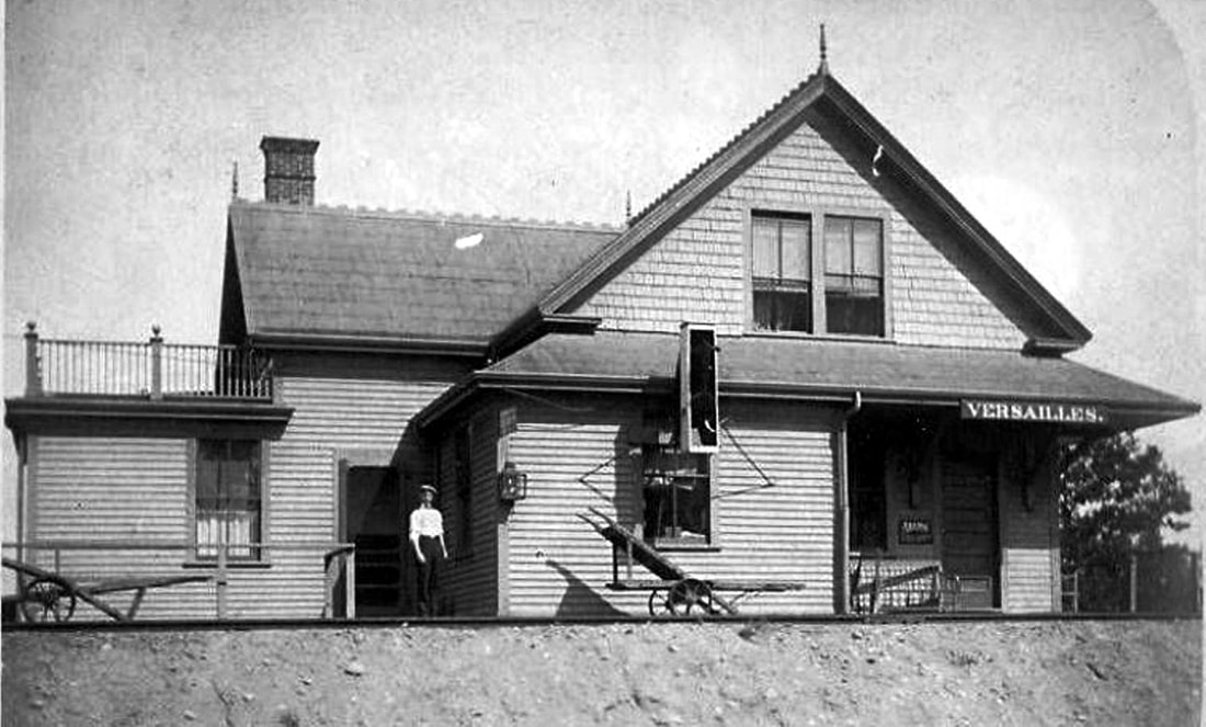
|
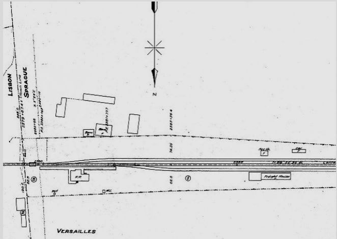
|

National Archives
|

|

|
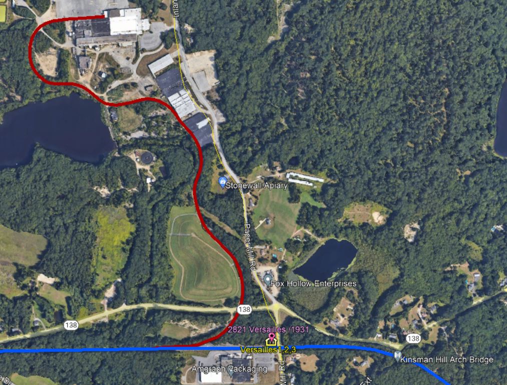
|
 Al Lawrence Collection
VERSAILLES3 [NYNH&H, 1905]
The earliest shot we have of this station is the 1910 view seen at [1]. The resident agent is posing for the photographer and we cannot fail to notice the old-style, slant-back baggage cart. The architectural plans we have in our collection carry a date of October, 1904 and, according to the railroad's annual report of December, 1905, this station was built during that calendar year. No mention of the fate of the preceding station or the construction of this one has been found either in the railroad commissioners' reports or in the newspapers. The 6/30/1915 ICC valuation map at [2] shows the layout of the grounds with both the passenger station and the freight depot which was a little farther west. The ICC valuation photo at [3] is dates to June, 1917. The shot at [4] is Lewis H. Benton's #2821 taken on 9/6/1931, that date inscribed by fellow photographer Irving N. Drake. He is posing in the left foreground in front of the station with his sedan, which carried the duo to locations across New England, at right. While Karr says passenger service was discontinued from Willimantic to Plainfield in 1927 or 1928, the shot at [5], which the NHRHTA Photo Archive dates to 10/7/1956, shows Budd car #24 (manufactured in 1952) doing the honors with what may be a young student just having disembarked. Was this some kind of special local train, perhaps in school service? The image at [6] is a snippet from our Track 11 Google Earth map, showing the ca. 1916 spur to the factory owned in later days by the Federal Paper Board Co. which once kept this station a busy place. After a number of subsequent owners operations ceased in 2014 and the spur track was removed. A 2/7/1969 Penn Central inventory labeled this former passenger station as "Freight house (Former dwelling)" and valued it at $5,000 plus $1,000 for the contents. Unanswered questions here are why this unusual residential-style station was built with interior appointments reportedly quite ornate and, of course, when and under what circumstances it came down. The 2/18/1910 tracing at [7] shows residential quarters on both the upper and lower levels, making it more house than depot and unlike any station floor plan we have seen elsewhere. The copy of this architectural drawing was found in the papers of the late Ed Sweeney of Norwood, MA and forwarded to us by long-time TCS contributor Richard Fleischer of Newton Centre, MA. Whatever its fate, a photo submission that won a Hartford Times contest in 1968 is captioned as follows: "The old railroad station at Versailles rests quietly in a state of dignified decline, symbol perhaps of another era and a silent testimonial of the current plight of the New Haven Railroad." We could not have said it better! Many thanks to Maureen at the Hartford History Center for her assistance in tracking this down for us. [REFS: NHAR34.1905.7; K84; HTI/02/12/1968/D1][rev020318, 091621, 042923]
The earliest shot we have of this station is the 1910 view seen at [1]. The resident agent is posing for the photographer and we cannot fail to notice the old-style, slant-back baggage cart. The architectural plans we have in our collection carry a date of October, 1904 and, according to the railroad's annual report of December, 1905, this station was built during that calendar year. No mention of the fate of the preceding station or the construction of this one has been found either in the railroad commissioners' reports or in the newspapers. The 6/30/1915 ICC valuation map at [2] shows the layout of the grounds with both the passenger station and the freight depot which was a little farther west. The ICC valuation photo at [3] is dates to June, 1917. The shot at [4] is Lewis H. Benton's #2821 taken on 9/6/1931, that date inscribed by fellow photographer Irving N. Drake. He is posing in the left foreground in front of the station with his sedan, which carried the duo to locations across New England, at right. While Karr says passenger service was discontinued from Willimantic to Plainfield in 1927 or 1928, the shot at [5], which the NHRHTA Photo Archive dates to 10/7/1956, shows Budd car #24 (manufactured in 1952) doing the honors with what may be a young student just having disembarked. Was this some kind of special local train, perhaps in school service? The image at [6] is a snippet from our Track 11 Google Earth map, showing the ca. 1916 spur to the factory owned in later days by the Federal Paper Board Co. which once kept this station a busy place. After a number of subsequent owners operations ceased in 2014 and the spur track was removed. A 2/7/1969 Penn Central inventory labeled this former passenger station as "Freight house (Former dwelling)" and valued it at $5,000 plus $1,000 for the contents. Unanswered questions here are why this unusual residential-style station was built with interior appointments reportedly quite ornate and, of course, when and under what circumstances it came down. The 2/18/1910 tracing at [7] shows residential quarters on both the upper and lower levels, making it more house than depot and unlike any station floor plan we have seen elsewhere. The copy of this architectural drawing was found in the papers of the late Ed Sweeney of Norwood, MA and forwarded to us by long-time TCS contributor Richard Fleischer of Newton Centre, MA. Whatever its fate, a photo submission that won a Hartford Times contest in 1968 is captioned as follows: "The old railroad station at Versailles rests quietly in a state of dignified decline, symbol perhaps of another era and a silent testimonial of the current plight of the New Haven Railroad." We could not have said it better! Many thanks to Maureen at the Hartford History Center for her assistance in tracking this down for us. [REFS: NHAR34.1905.7; K84; HTI/02/12/1968/D1][rev020318, 091621, 042923]
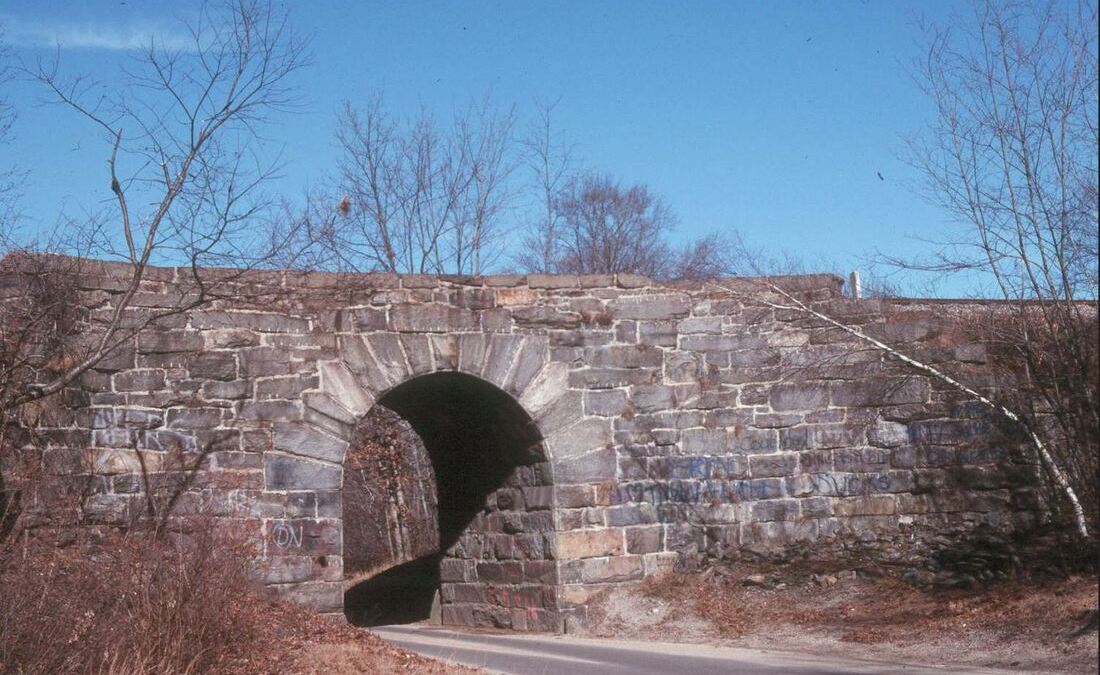
Bridgehunter.com
|
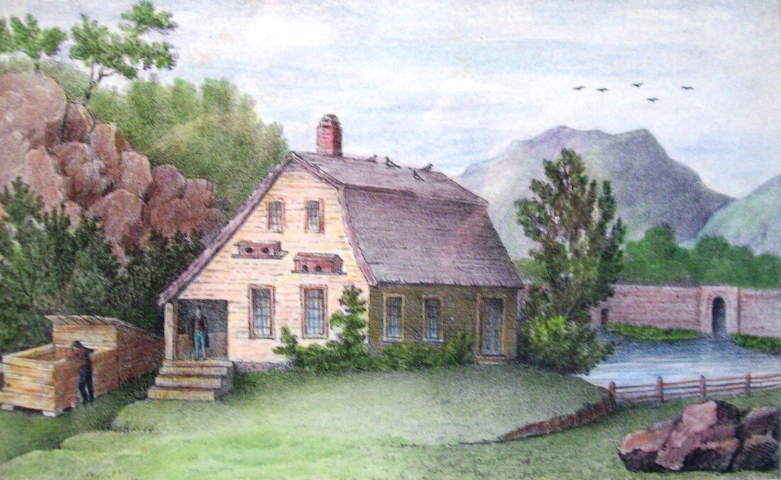
|
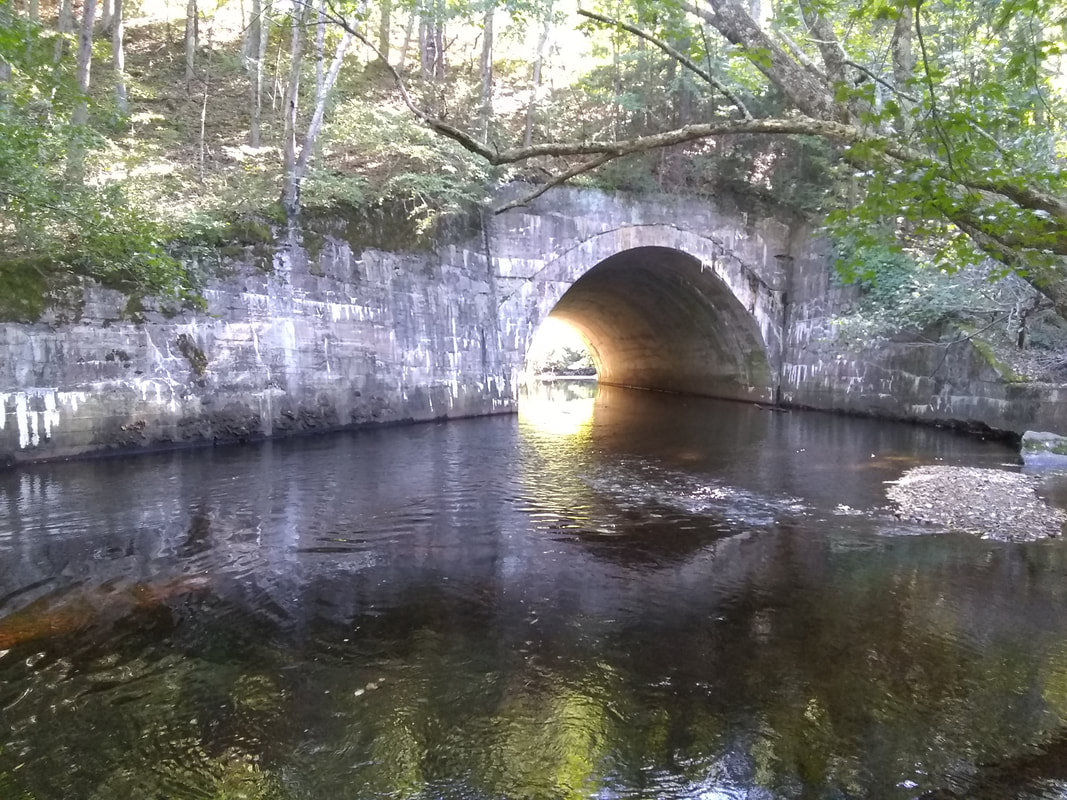
|
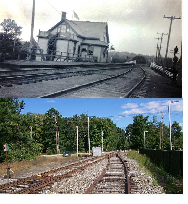
We could not help noticing the mention on the GE map of the Kinsman Hill Road arch bridge. Notice in the photo at [1] the curved wing walls which we think date this structure to the 1854 opening of the HP&F. A similar structure of that era once existed on the Canal line at Granby. One of our contributors also provided the image at [2] which is an artist's rendition of another culvert just to the west over a Shetucket River tributary. His 9/19/21 photo is at [3]. Some beautiful and historic railroad construction to be seen here! His final contribution is the lower shot at [4] in a composite with the 1917 ICC valuation photo showing the station site looking east to the aptly named Paper Mill Rd. [rev022422, 042923].