Track 12: CT Passenger Stations, H-HA
See TCS Home Page links for notes, abbreviations, and sources.
Use Track 11 map link to locate stations, rail and trolley lines, and POIs.
Use Track 11 map link to locate stations, rail and trolley lines, and POIs.
HADDAM1 [CV, 1871]
This station was up on the CV's opening day in 1871. It burned in 1914. We have no photo as of yet.
This station was up on the CV's opening day in 1871. It burned in 1914. We have no photo as of yet.

Dave Peters Collection
|

|
HADDAM2 [NYNH&H, 1914]
This station was built in 1914 after HADDAM1 burned. HADDAM2 was later sold and moved. The photo on the right is a c1930 Benton and Drake. [REFS: HDC/08/25/1871/02; NHAR44.1915.10]
This station was built in 1914 after HADDAM1 burned. HADDAM2 was later sold and moved. The photo on the right is a c1930 Benton and Drake. [REFS: HDC/08/25/1871/02; NHAR44.1915.10]
HADLYME1 [CV, 1871; depot, 1884]
According to Max Miller, this stop in the town of CHESTER was established at the opening of the CV in 1871 but there was no station until HADLYME1 was built in 1884. The station burned in 1903.
According to Max Miller, this stop in the town of CHESTER was established at the opening of the CV in 1871 but there was no station until HADLYME1 was built in 1884. The station burned in 1903.

|

|
HADLYME2 [NYNH&H, 1903][rev090319]

Lee Carlson photo
|

Lee Carlson photo
|
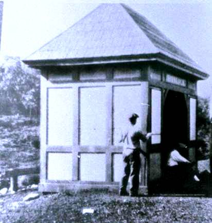
HADLYME3 [VRR, 2009]
This structure, built by the Friends of the Valley Railroad, debuted on 7/18/2009. VRR passengers who use the flag stop here to catch the ferry to Gillette Castle now have some place to be shielded from the elements. The depot is a post and beam, mortise and tenon structure that uses no nails in the framing. It stands in the same spot as HADLYME2 and was modeled on SOUTH BRITAIN. The No. 97 is headed north in the shot to the right. Max Miller did the signboard with his usual precision. Thanks to Lee Carlson and the FVRR for the work, the photos, and the info, all of which make this railroad the great success it is today. [rev010318]
This structure, built by the Friends of the Valley Railroad, debuted on 7/18/2009. VRR passengers who use the flag stop here to catch the ferry to Gillette Castle now have some place to be shielded from the elements. The depot is a post and beam, mortise and tenon structure that uses no nails in the framing. It stands in the same spot as HADLYME2 and was modeled on SOUTH BRITAIN. The No. 97 is headed north in the shot to the right. Max Miller did the signboard with his usual precision. Thanks to Lee Carlson and the FVRR for the work, the photos, and the info, all of which make this railroad the great success it is today. [rev010318]
|

|
|
|
HAMDEN PLAINS [NH&N, 1848]
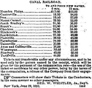
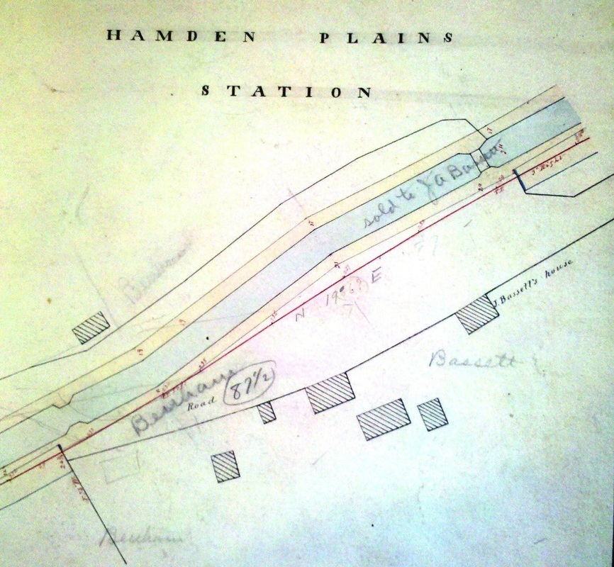
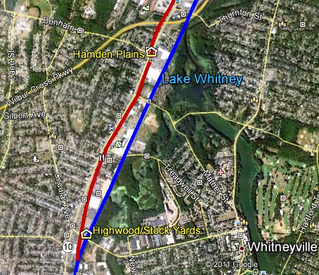
This stop was four miles north of the Austin depot in New Haven on the Canal line, according to 1851 and 1858 timetables and it is no longer seen by 1871. The 1852 snippet at upper left lists it during the period when the NH&N was leased by the NY&NH, with the son of legendary railroad builder George Washington Whistler acting as superintendent with his office in New York City. The 1852NH map at left center shows the location. According to the records of the railroad commissioners in RG 041 at CSL, a letter dated 5/5/1877 from G.S. Benham complains about the removal of planking that he would like to have restored "from an old highway crossing (near the site of Hamden Plains station discontinued)..." The map at right center is from an early real estate atlas found at the New Haven Museum, which has a number of these rare and valuable NYNH&H-predecessor property books. It still shows the canal, a piece of it sold to a Mr. J.A. Bassett. The red line is the track which crosses to the west side of the road that would be named Dixwell Ave. at a later date. We assume that the discontinued station stood at the crossing where the planking once was. Comparing all this evidence, we think that this location was at Benham Ave. where we have placed it on the snippet from our CTTRAXMAP at right. We have no picture yet of whatever station structure served here as HAMDEN PLAINS. [REFS: 1851TT; HDC/07/08/1852/01; PTT197.1858.15; PTT380.1871.18; RRC24.44 (6/8/1877)][rev102213]
This stop was four miles north of the Austin depot in New Haven on the Canal line, according to 1851 and 1858 timetables and it is no longer seen by 1871. The 1852 snippet at upper left lists it during the period when the NH&N was leased by the NY&NH, with the son of legendary railroad builder George Washington Whistler acting as superintendent with his office in New York City. The 1852NH map at left center shows the location. According to the records of the railroad commissioners in RG 041 at CSL, a letter dated 5/5/1877 from G.S. Benham complains about the removal of planking that he would like to have restored "from an old highway crossing (near the site of Hamden Plains station discontinued)..." The map at right center is from an early real estate atlas found at the New Haven Museum, which has a number of these rare and valuable NYNH&H-predecessor property books. It still shows the canal, a piece of it sold to a Mr. J.A. Bassett. The red line is the track which crosses to the west side of the road that would be named Dixwell Ave. at a later date. We assume that the discontinued station stood at the crossing where the planking once was. Comparing all this evidence, we think that this location was at Benham Ave. where we have placed it on the snippet from our CTTRAXMAP at right. We have no picture yet of whatever station structure served here as HAMDEN PLAINS. [REFS: 1851TT; HDC/07/08/1852/01; PTT197.1858.15; PTT380.1871.18; RRC24.44 (6/8/1877)][rev102213]
HAMPTON1 [BH&E, 1872; opens as RAWSON; depot, c1873]
This stop was established in the town of the same name in 1872 when the BH&E opened the line between PUTNAM and WILLIMANTIC. Apparently, there was no station structure here at the beginning and the railroad commissioners ordered one early in 1873. We have not found a photograph yet but the commissioners were called upon late in 1875 to act on the complaints of residents about the poor condition of the passenger accommodations here. The petition said that the "shanty" was about eight feet square, had broken windows, no stove, and roof so leaky "that it is but little use to go into said building for protection." As late as 1877, the commissioners were suggesting that MECHANICSVILLE1 could be brought here but there is no evidence that the transfer was ever completed. [REFS: RRC8.388 (10/27/1873); RRC26.3 (1/5/1876)][rrd012223]
This stop was established in the town of the same name in 1872 when the BH&E opened the line between PUTNAM and WILLIMANTIC. Apparently, there was no station structure here at the beginning and the railroad commissioners ordered one early in 1873. We have not found a photograph yet but the commissioners were called upon late in 1875 to act on the complaints of residents about the poor condition of the passenger accommodations here. The petition said that the "shanty" was about eight feet square, had broken windows, no stove, and roof so leaky "that it is but little use to go into said building for protection." As late as 1877, the commissioners were suggesting that MECHANICSVILLE1 could be brought here but there is no evidence that the transfer was ever completed. [REFS: RRC8.388 (10/27/1873); RRC26.3 (1/5/1876)][rrd012223]

|

|
|
HAMPTON2 [NY&NE, 1894]
The railroad commissioners said in their December, 1894 annual report that new depots had been built here and at TOWANTIC within the calendar year. While they say that the other was a replacement for one that burned, they say nothing about the circumstances that required a new structure here. There is the strong possibility that the earlier deficient structure was finally replaced because it is hard to imagine that the NY&NE could get away with 20 more years of inadequate facilities here. More research would be needed to prove that there was an additional depot here from say 1880 to 1894. Glossing over that speculation at this time, the image at [1] is HAMPTON2 ca. 1900 according to the date given on one copy we have. The undated shot at [2] shows a busy location with what is probably the daily milk train stopping for the region's dairy product. The PUC inspection photo at [3] is from the 1920s but unfortunately the last digit of the date has been cut off on all the copies we have. The name of this station was changed to RAWSON possibly in 1915 with the ICC directive to eliminate names that might be confused with other locations by train crews. [REFS: CRC42.1894.22][rev060513, 012223]
The railroad commissioners said in their December, 1894 annual report that new depots had been built here and at TOWANTIC within the calendar year. While they say that the other was a replacement for one that burned, they say nothing about the circumstances that required a new structure here. There is the strong possibility that the earlier deficient structure was finally replaced because it is hard to imagine that the NY&NE could get away with 20 more years of inadequate facilities here. More research would be needed to prove that there was an additional depot here from say 1880 to 1894. Glossing over that speculation at this time, the image at [1] is HAMPTON2 ca. 1900 according to the date given on one copy we have. The undated shot at [2] shows a busy location with what is probably the daily milk train stopping for the region's dairy product. The PUC inspection photo at [3] is from the 1920s but unfortunately the last digit of the date has been cut off on all the copies we have. The name of this station was changed to RAWSON possibly in 1915 with the ICC directive to eliminate names that might be confused with other locations by train crews. [REFS: CRC42.1894.22][rev060513, 012223]
HANCOCK [HP&F, 1855]
This stop in the town of Plymouth was established in 1855 when the HP&F extended its line from Bristol to Waterbury. This looks like a more modern structure that may have been preceded by an earlier one. [REFS: D134]
This stop in the town of Plymouth was established in 1855 when the HP&F extended its line from Bristol to Waterbury. This looks like a more modern structure that may have been preceded by an earlier one. [REFS: D134]
|
|
|
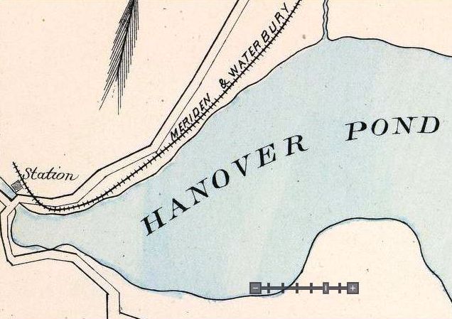
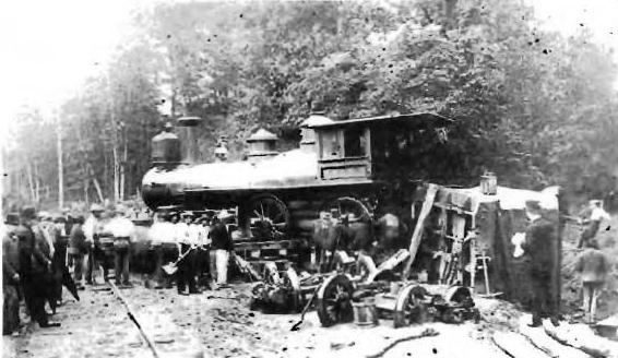
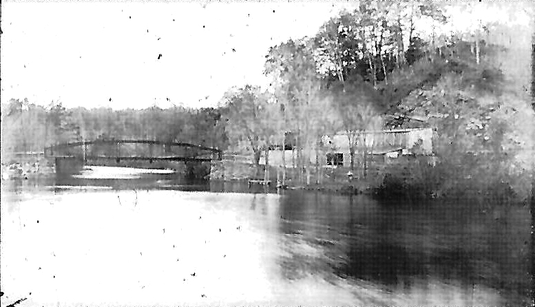
HANOVER [M&W, c1890]
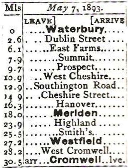
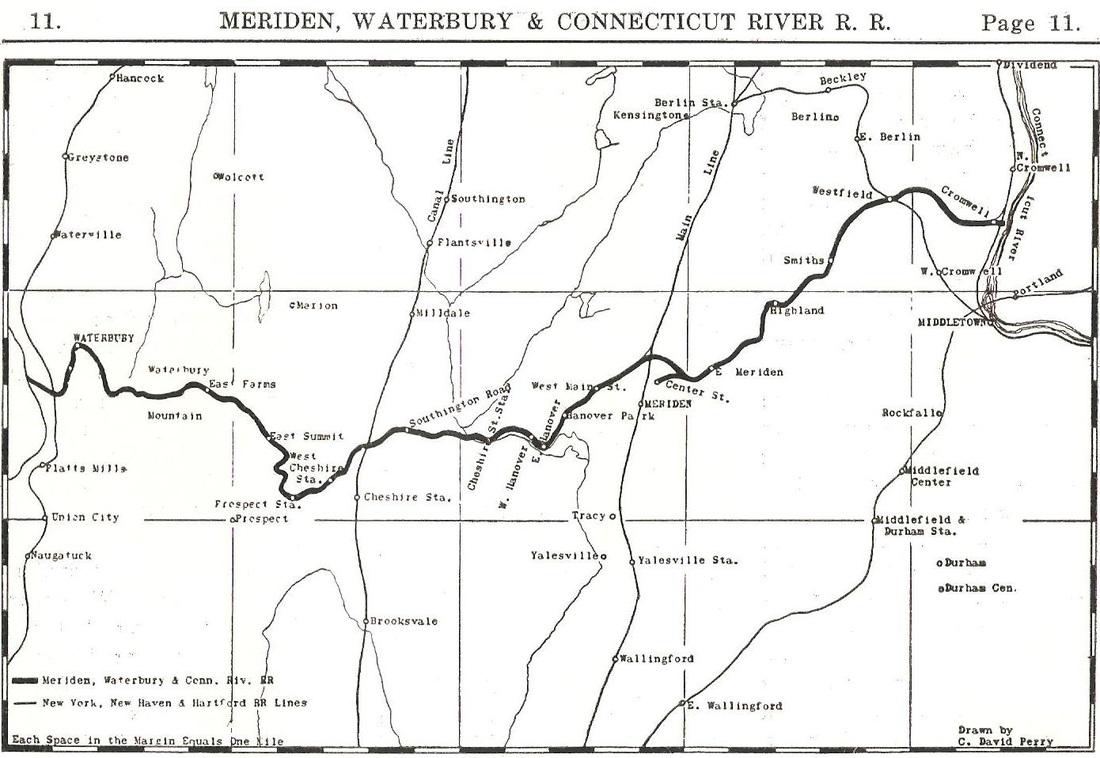
This MERIDEN stop was not an original station in 1888 when the M&W opened between Meriden and Waterbury. The location is seen in the lower left corner of the 1893 Hurd's Connecticut atlas map at [1] and the timetable of that same year at [4] also lists the station by that time. Snow's map, shown in our next listing, designates this stop as EAST HANOVER, with an otherwise undocumented WEST HANOVER as well. The 1915 val map [not shown] does not even indicate an abandoned station here by that time. This location was also known as RED BRIDGE. Though we have not seen that name on any timetable, a serious wreck [2] on 8/10/1888 put this spot and the line, newly christened as the MW&CR, in the news. The lenticular pony truss seen in the photo at [3] reportedly came in 1891. It was purchased from the Berlin Iron Bridge Co. and perpetuated the Red Bridge name that came from the color of its wooden predecessor. The structure, now closed to traffic, has an NRHP designation and is well preserved today. In the photo, you can see a box car parked on a siding at the cutlery factory that was located here. [REFS: HC/10/27/1891/06; HC/01/24/1910/03; S11,29][rev070315, 121218]
This MERIDEN stop was not an original station in 1888 when the M&W opened between Meriden and Waterbury. The location is seen in the lower left corner of the 1893 Hurd's Connecticut atlas map at [1] and the timetable of that same year at [4] also lists the station by that time. Snow's map, shown in our next listing, designates this stop as EAST HANOVER, with an otherwise undocumented WEST HANOVER as well. The 1915 val map [not shown] does not even indicate an abandoned station here by that time. This location was also known as RED BRIDGE. Though we have not seen that name on any timetable, a serious wreck [2] on 8/10/1888 put this spot and the line, newly christened as the MW&CR, in the news. The lenticular pony truss seen in the photo at [3] reportedly came in 1891. It was purchased from the Berlin Iron Bridge Co. and perpetuated the Red Bridge name that came from the color of its wooden predecessor. The structure, now closed to traffic, has an NRHP designation and is well preserved today. In the photo, you can see a box car parked on a siding at the cutlery factory that was located here. [REFS: HC/10/27/1891/06; HC/01/24/1910/03; S11,29][rev070315, 121218]
|
|
Phil Wooding Collection
|
HANOVER PARK [NYNH&H, c1900]
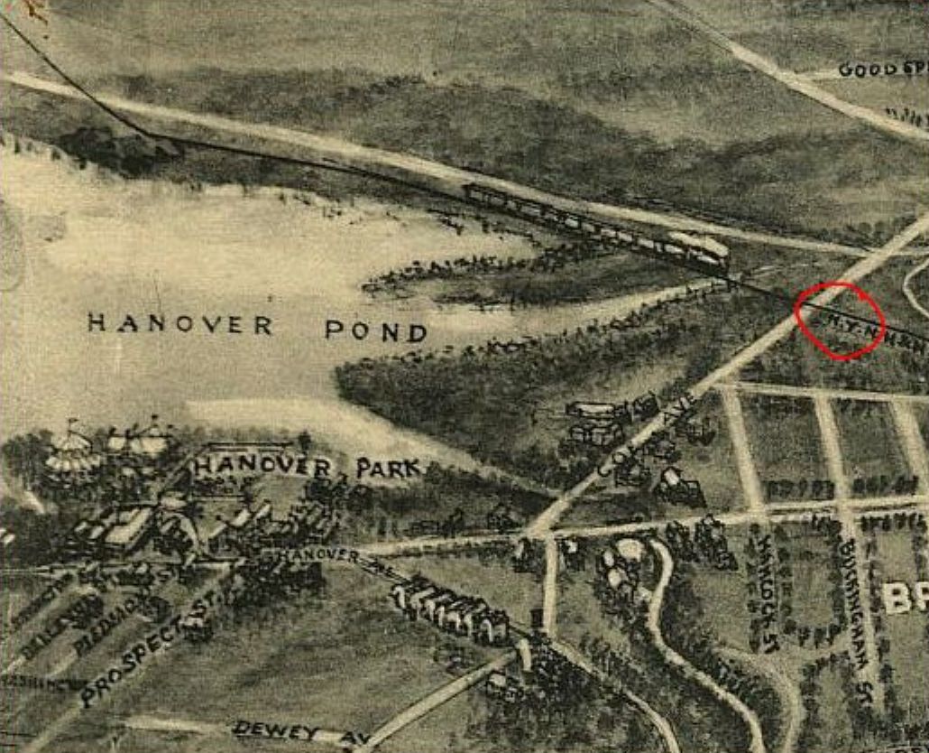
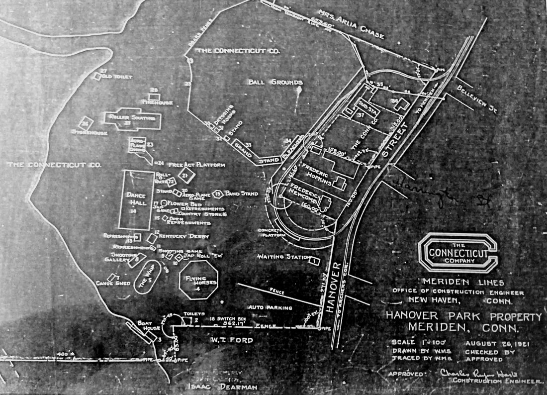
This stop was one mile west of the MW&CR's West Main St. station in MERIDEN. No stop is seen here upon the opening of the railroad in 1888 but it appears as HANOVER on a 1900 NYNH&H timetable, as HANOVER PARK in the 1907 ABC Pathfinder guide, and as indicated on Snow's map at [1]. The park facility itself was one of the many in the state that were created or subsequently operated by railroads and trolley companies to increase ridership and profits, especially on the less busy weekend days. This one was the property of the Meriden Street Rwy and it was later acquired by the Connecticut Co. A popular destination, it saw picnics and boating, baseball games and athletic events, and, in the 1930s, dance marathons. There was reportedly only a platform here, which is not seen either on the 1915 val map or on the 1918 Bailey aero view at [2]. Rail service ended on this line on 6/24/1917 though trolleys and buses continued to bring people to the park until the 1940s. The Connecticut Company map of the facilities at [3] is dated 8/26/1921 and signed by Construction Engineer Charles Rufus Harte. Harte was also a engineering and transportation historian who took a special interest in the Farmington Canal and captured many of the structures of his day on film. [REFS: HC/06/27/1896/03; Hill, 1.88; S14,29][rev032113, 110420]
This stop was one mile west of the MW&CR's West Main St. station in MERIDEN. No stop is seen here upon the opening of the railroad in 1888 but it appears as HANOVER on a 1900 NYNH&H timetable, as HANOVER PARK in the 1907 ABC Pathfinder guide, and as indicated on Snow's map at [1]. The park facility itself was one of the many in the state that were created or subsequently operated by railroads and trolley companies to increase ridership and profits, especially on the less busy weekend days. This one was the property of the Meriden Street Rwy and it was later acquired by the Connecticut Co. A popular destination, it saw picnics and boating, baseball games and athletic events, and, in the 1930s, dance marathons. There was reportedly only a platform here, which is not seen either on the 1915 val map or on the 1918 Bailey aero view at [2]. Rail service ended on this line on 6/24/1917 though trolleys and buses continued to bring people to the park until the 1940s. The Connecticut Company map of the facilities at [3] is dated 8/26/1921 and signed by Construction Engineer Charles Rufus Harte. Harte was also a engineering and transportation historian who took a special interest in the Farmington Canal and captured many of the structures of his day on film. [REFS: HC/06/27/1896/03; Hill, 1.88; S14,29][rev032113, 110420]
HANOVER/NEWTOWN > NEWTOWN/N
|
National Archives
|
|
Litchfield Historical Society
|

|
|

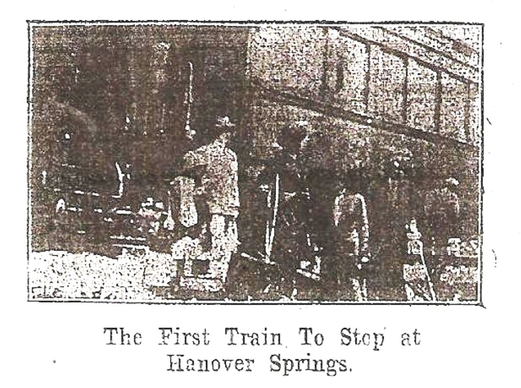
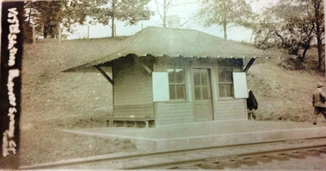
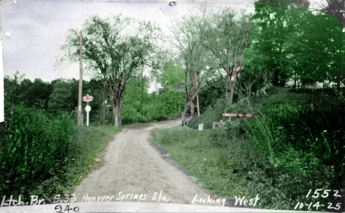
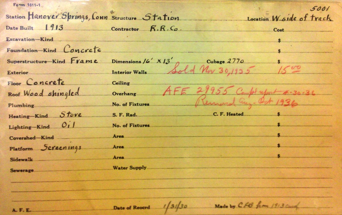
HANOVER SPRINGS [NYNH&H, 1912; depot, 1913]
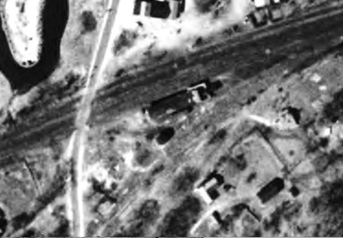
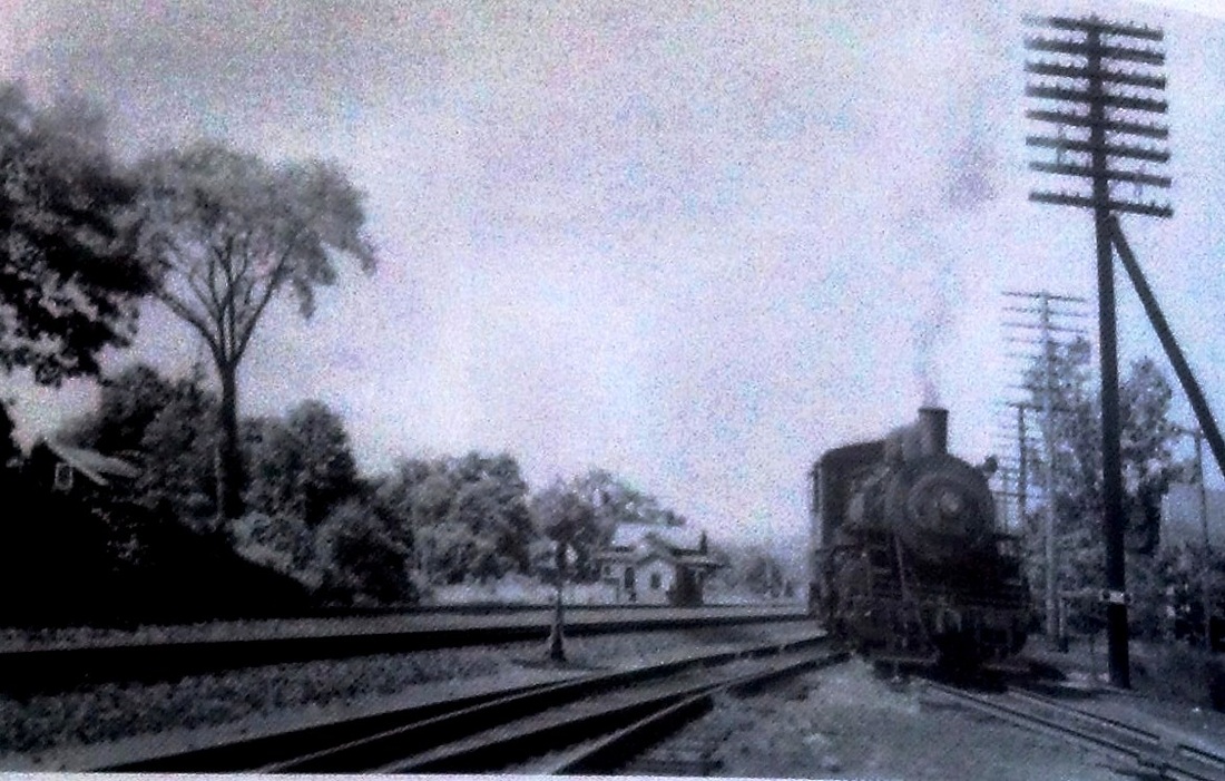
This station was in far northern part of NEWTOWN, 3.39 miles above HAWLEYVILLE, a point which made it the first stop on the Litchfield Branch. Service to what was originally called Mulligan's Crossing began in 1912 and timber was on the ground in April, 1913 for a structure. The Bridgeport Evening Farmer elaborated, saying that "... Mulligan's Crossing is a new station on the Shepaug and Litchfield branch of the Highland Division of the New York, New Haven & Hartford railroad. This new station is in the Hanover district, Newtown, and is for the benefit of the colony of New Yorkers in that vicinity. Pond Brook, a famous trout stream nearby, is, seemingly, the center of attraction for the new settlement of bungalow dwellers in this neck of land." It also corroborates the build date and extols the impact of the railroad on local prosperity, saying that "Railroads are prime factors in opening new countries or assisting in bringing back abandoned communities back into active settlements. In May of 1913, the New York, New Haven and Hartford Road, seeing the advantages in giving Hanover Springs a stop and station on the Litchfield Branch passing through all these properties, did so. When this stop was made at Hanover Springs it brought the farms one hour nearer Greater New York." The comments are especially significant about the reclamation of farms when they were abandoned for urban life and factory jobs in the late 1800s. Edwin Storrs' Shoreliner article echoes the rediscovery of rural retreat and the cottagers' call for a station here so that they would not have to drive to Hawleyville to take the train back to New York City. The other 'creation story' is that tea-bag impressario William Abel Upham requested the stop for easy access from Hanover to the old curtain factory across from the HAWLEYVILLE station that he purchased in 1916 and converted to Upham Food Products. Carrying the rural and comestibles theme further, the locale would be closely associated for the next several years with Paul Pierce, pure-food promoter, advocate of a local farm-loan association, and editor of the National Food Magazine which he published from his nearby home. The build date on the NYNH&H real estate card is, in fact, 1913, with this neat 13x16x10 feet having a granolithic floor and was fronted by a crushed-stone platform. The cars also records the sale of this structure on 11/30/1935 per AFE #29955 and its removal in October, 1936; sale price: $15.00. A coincidental 1936 article in the Bridgeport Post noted that this station had been sold to J.J. Coffey, Jr. of 99 White St., Danbury who planned to move it along the Housatonic River and remodel it into a summer residence. We would love to know if it is still standing and where. Many thanks to all the folks at the Cyrenius H. Booth Library Reference Desk for their research assistance! What would we do without our libraries and historical societies?
IMAGES: [1] Photo from September, 1914 Newtown Bee article, first train stopping here presumably in 1912; [2] 10/9/1916 valuation photo; [3] 10/14/1925 PUC shot colorized by Al Weaver; [4] 1935-updated real estate card; [5] reportedly 1940 but must be prior to 1936 removal; [6] Al Weaver's overlay of 06/30/1915 valuation map; [7] ca 2010 photo showing concrete curbing still in ground. Location now Lake Lilinoah Boat Launch area.
REFERENCES: Form220LWTTrev7/2/1912: no; Form220 LWTTrev6/29/14: yes; NBE/04/18/1913/02; BEF/04/21/1913/15; NBE/09/25/1914/01,03,14; BEF/09/29/1914/05; BEF/01/21/1916/19; BP/02/01/1936/18; D158; IOA Newtown, ch. 8; SL11.1.26.
TCS REVISIONS:12/29/2017, 6/17/2022.

|
|
|
Max Miller Collection
|

|
|
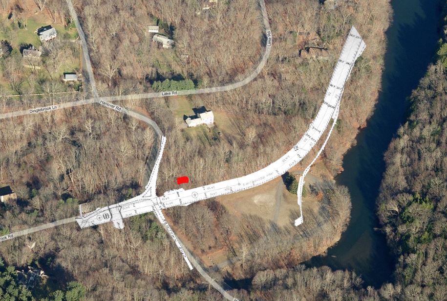
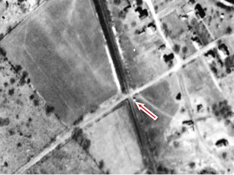
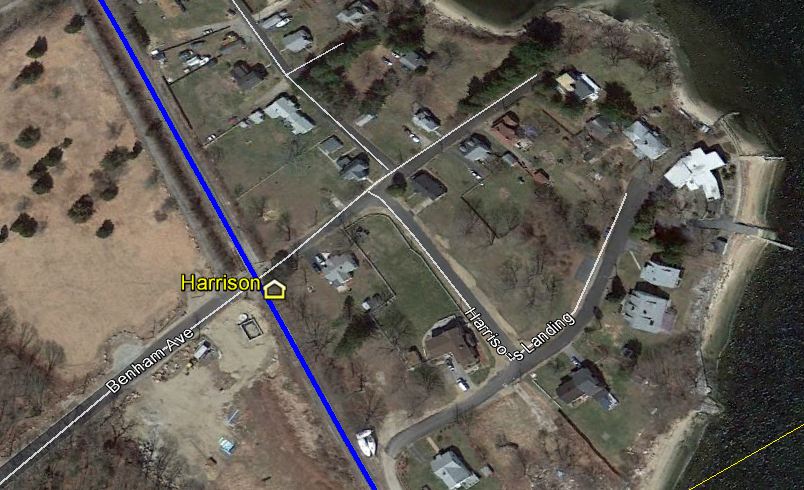
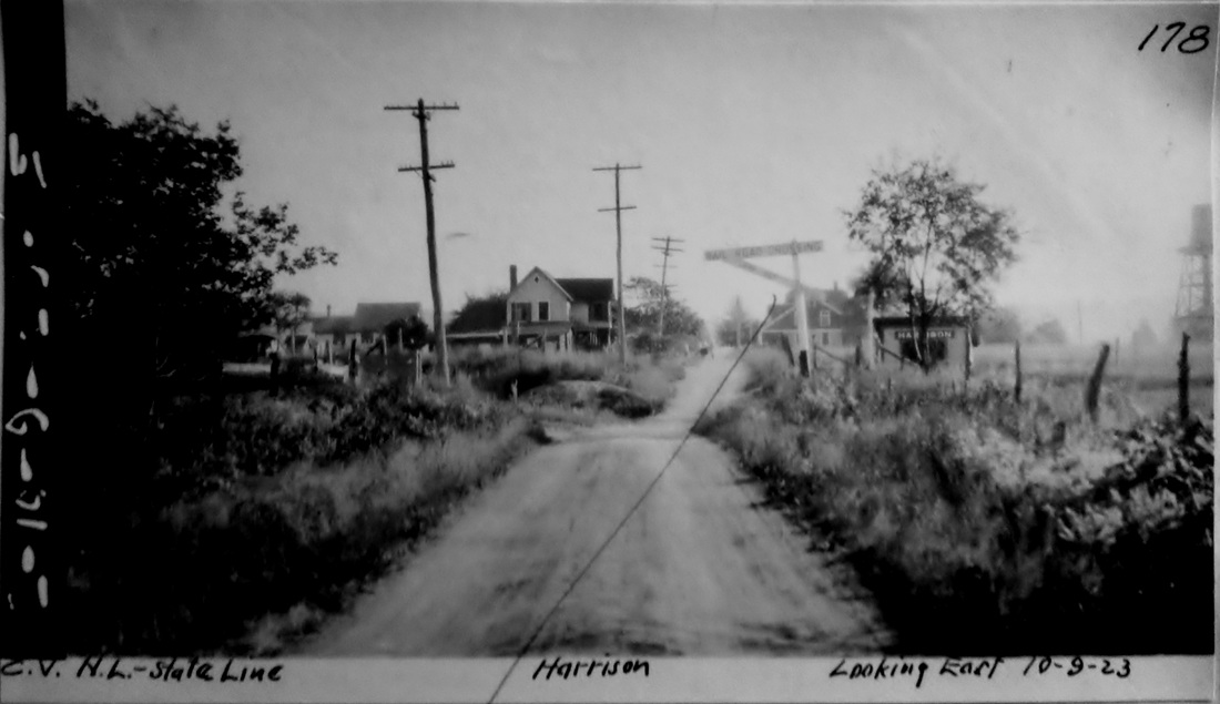
HARRISON [CVT, c1882]
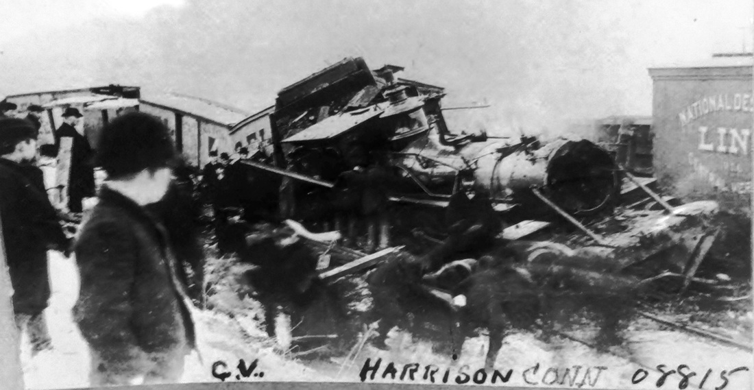
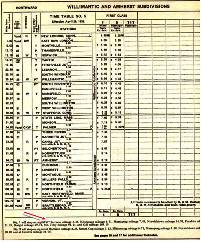
The first reference to this station in the town of WATERFORD is a Courant article in late 1882 and it appears on the RRMs from 1881 to 1912, though it escaped inclusion on the 1883 NLN atlas. A 1900 CVT timetable and the RAM maps show it as being two miles above New London. Image [1] gives us a look at the side and back benches inside this spartan accommodation that stood in the southeast quadrant of the grade crossing. Image [2] shows the outline from the 1934 aerial map and [3] pinpoints it on our Track 11 map. Shot [4] is a 10/9/1923 PUC photo and [5] is a 1930s Lewis H. Benton image that captures 'chauffeur' Irving N. Drake peeking out. Trains were signalled to stop by raising the red ball that is seen over the shelter. This location saw its share of excitement during the famed collegiate rowing competitions on the Thames River. Those meets for a time included teams other than the top-billed Yale and Harvard race; the Cornell team was actually headquartered here at Harrison's Landing, seen at the foot of Benham St. on the present-day map [3]. Sometimes referred to as MAMACOKE for the adjacent cove, this was the southern end of the four mile course that began at BARTLETTS. This station was in the news in 1892 for a fatal, head-on collision of two trains about 1,000 feet south of HARRISON. The NLN's Norwich operator, Thomas K. Carroll, 20 years of age and serving both as telegrapher and switchman on 11-hour shifts for $1.50 per night, was blamed for being asleep and missing the passage of the southbound train. The railroad was censured both for overburdening the operator and for positioning a car carrying four valuable horses and their attendants, en route to the races at Poquonnock, immediately behind the engine. All were killed in the crash which may be pictured in image [6]. Passenger service on this CVT line ended in 1947 and how long this station was in use is unclear. ETT #5 (4//26/1936) at [7] left still shows it as a flag stop at that time but an 11/4/1944 schedule shows all the flag stops eliminated at least by then. [REFS: NLDC/0713/1857/02; HDC/11/15/1882/04; NHER/09/13/1883/01; NHER/10/14/1892/01; NHER/10/21/1892/04; NYH/10/15/1892/10; NYHT/10/15/ 1892/01; NYT/10/21/1892/03; K101][rev020914]
The first reference to this station in the town of WATERFORD is a Courant article in late 1882 and it appears on the RRMs from 1881 to 1912, though it escaped inclusion on the 1883 NLN atlas. A 1900 CVT timetable and the RAM maps show it as being two miles above New London. Image [1] gives us a look at the side and back benches inside this spartan accommodation that stood in the southeast quadrant of the grade crossing. Image [2] shows the outline from the 1934 aerial map and [3] pinpoints it on our Track 11 map. Shot [4] is a 10/9/1923 PUC photo and [5] is a 1930s Lewis H. Benton image that captures 'chauffeur' Irving N. Drake peeking out. Trains were signalled to stop by raising the red ball that is seen over the shelter. This location saw its share of excitement during the famed collegiate rowing competitions on the Thames River. Those meets for a time included teams other than the top-billed Yale and Harvard race; the Cornell team was actually headquartered here at Harrison's Landing, seen at the foot of Benham St. on the present-day map [3]. Sometimes referred to as MAMACOKE for the adjacent cove, this was the southern end of the four mile course that began at BARTLETTS. This station was in the news in 1892 for a fatal, head-on collision of two trains about 1,000 feet south of HARRISON. The NLN's Norwich operator, Thomas K. Carroll, 20 years of age and serving both as telegrapher and switchman on 11-hour shifts for $1.50 per night, was blamed for being asleep and missing the passage of the southbound train. The railroad was censured both for overburdening the operator and for positioning a car carrying four valuable horses and their attendants, en route to the races at Poquonnock, immediately behind the engine. All were killed in the crash which may be pictured in image [6]. Passenger service on this CVT line ended in 1947 and how long this station was in use is unclear. ETT #5 (4//26/1936) at [7] left still shows it as a flag stop at that time but an 11/4/1944 schedule shows all the flag stops eliminated at least by then. [REFS: NLDC/0713/1857/02; HDC/11/15/1882/04; NHER/09/13/1883/01; NHER/10/14/1892/01; NHER/10/21/1892/04; NYH/10/15/1892/10; NYHT/10/15/ 1892/01; NYT/10/21/1892/03; K101][rev020914]
|

|
|
|
|
|
HARTFORD1 [H&NH, 1839]
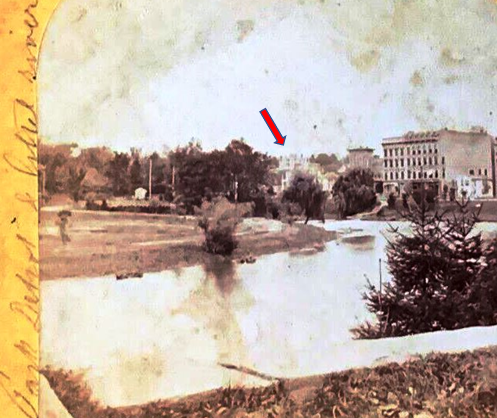
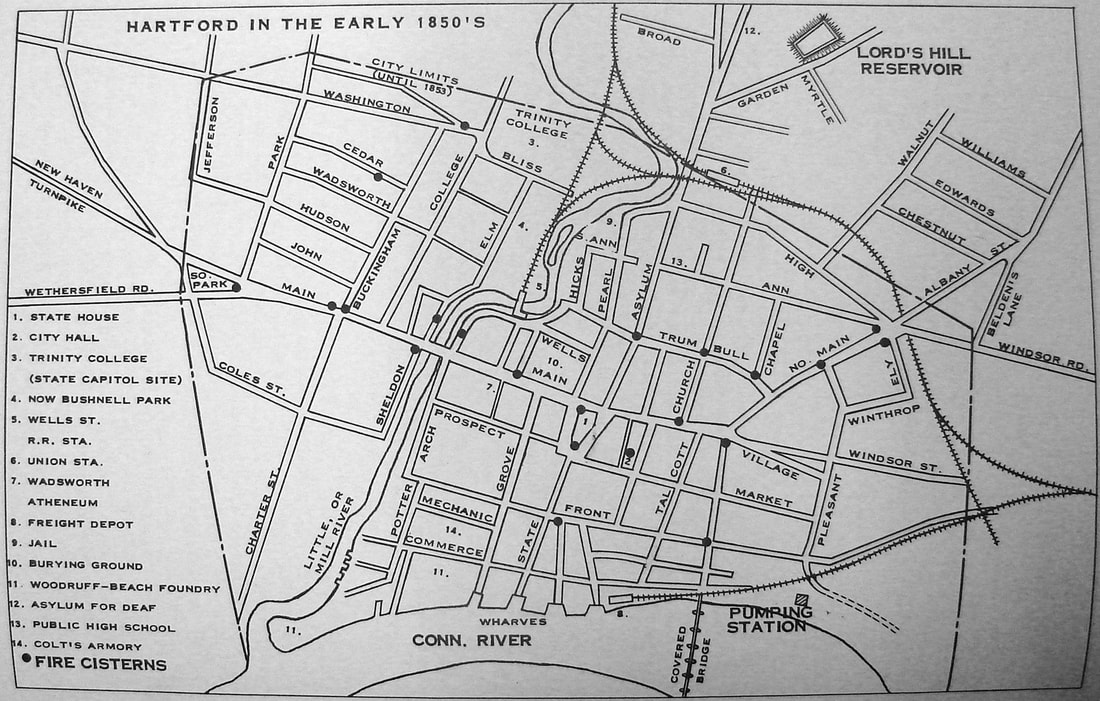
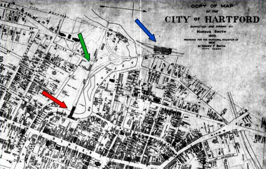
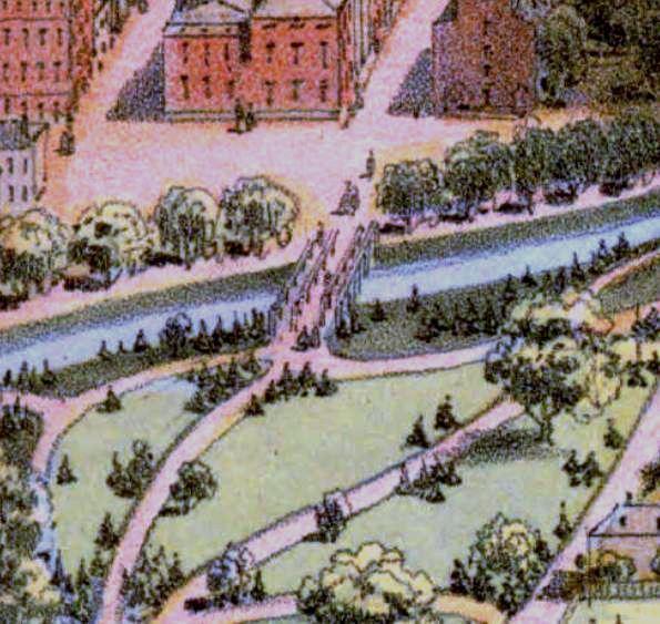
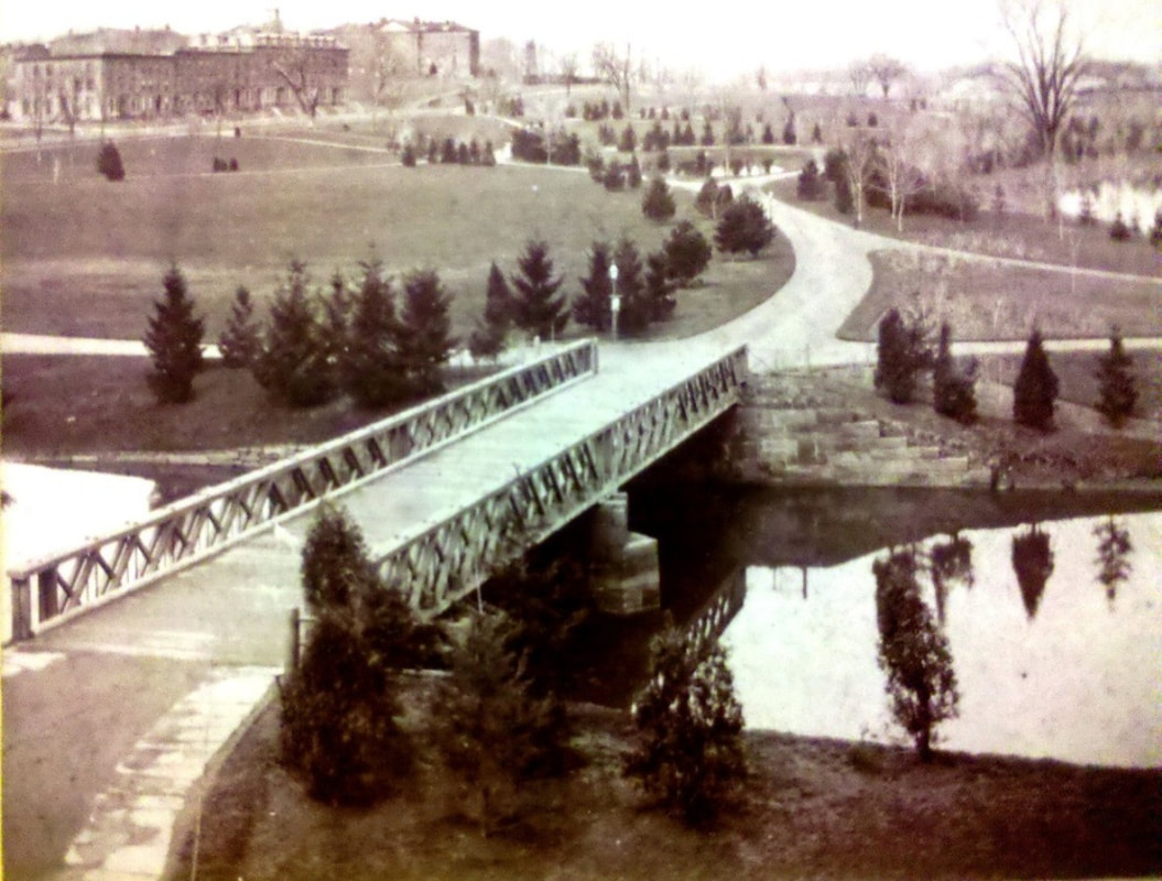
An early 1840 Courant article heralded the opening of the first station in the state capital and described it as a 60x187-ft, two-story brick structure, with an address given by the 1840GHD as 42 Mill St. A very detailed 1901 article said this depot was open for the arrival of the first train from the south on 12/13/1839 and describes the station as "an unpretentious structure... barnlike in appearance... wooden... closed in by clapboarding" and high enough in the shed part to allow passenger cars to enter. The front on Mill St. was two stories high, with a waiting room and ticket office on the first floor and railroad offices above. According to the 1839 annual report, the cost of the engine house and depot buildings, a little farther to the west, was $6,000. The image as [1] is taken from a stereograph of the 1850s. The handwriting on the left edge says "Park Depot & hotel river." Our red arrow points to what we think might be the first depot of which no other image seems to exist. Al Weaver colorized the idyllic pastoral representation at [2] which is from an 1895 periodical article. It shows the tail end of a coach on a train that is heading west from the station and about to pass the buildings of the original Trinity College standing where the state capitol is today. The 1840 article also noted the 60x225-ft bridge over the river behind the station with four tracks, two each to serve passengers and freight shipments. The map at [3] shows the layout prior to the creation of Hartford Park, today's Bushnell Park, in the area west of HARTFORD1, the title to the roadbed passing from the H&NH to the city as of 4/1/1856. In the map we see the smaller triangular 1839 track wye that enabled trains arriving from the south to pull up to Asylum St, back into the HARTFORD1 terminus, and depart the station in the opposite direction. The outer, larger wye track was built to go directly to the new 1850 Union Station, HARTFORD2. The red arrow on the map at [5], also pre-park, points to HARTFORD1, here labeled as the Welles St station in the map key. At the green arrow are the H&NH roundhouse and shops. The blue arrow points to HARTFORD2 and the larger wye to serve the track now going through the station. Recent research has clarified that the HARTFORD1 structure lasted to until 1859-1860 when it was sold and dismantled for its usable building materials. Where the four-track bridge had once crossed the river, a new Mulberry St. structure was built as an eastern entrance to the park. The snippet at [5] from John Bachmann's 1864 bird's-eye map shows the new bridge. It appears in the ca. 1880 stereo card at [6] that the original stone piers and abutments which once supported the railroad bridge were retained for the new one. Flood control projects in the 1930s buried the Park River; all that is left is a plaque commemorating the location of the first railroad station. Bushnell Park is still thought to be the first publicly funded municipal park in the country for which the famed landscape designer Frederick Law Olmstead was tapped for the original plan. The park was renamed for Rev. Dr. Horace Bushnell in 1876 to honor him for his efforts promoting the purchase of the land as a public space. The park, still an Insurance City gem, received an NRHP designation on 10/22/1970. [REFS: HNHAR4.1839.5; HDC/01/02/1840/02; HNHAR6.1841.5; HDC/01/01/1846/02; CRC4.1857.8; HDC/09/16/1847/02; SR/09/12/1850/02; HDC/07/27/1858/02; HDC/09/30/1858/02; HDC/10/09/1858/02; HDC/07/06/1859/02; HDC/01/05/1860/02; HDC/02/16/1876/02; Connecticut Magazine, v1 (1895), p68-69; HC/08/03/1901/09; HC/04/13/1930/E1; SL31.3.11][rev123113, 0514019, 012323]
An early 1840 Courant article heralded the opening of the first station in the state capital and described it as a 60x187-ft, two-story brick structure, with an address given by the 1840GHD as 42 Mill St. A very detailed 1901 article said this depot was open for the arrival of the first train from the south on 12/13/1839 and describes the station as "an unpretentious structure... barnlike in appearance... wooden... closed in by clapboarding" and high enough in the shed part to allow passenger cars to enter. The front on Mill St. was two stories high, with a waiting room and ticket office on the first floor and railroad offices above. According to the 1839 annual report, the cost of the engine house and depot buildings, a little farther to the west, was $6,000. The image as [1] is taken from a stereograph of the 1850s. The handwriting on the left edge says "Park Depot & hotel river." Our red arrow points to what we think might be the first depot of which no other image seems to exist. Al Weaver colorized the idyllic pastoral representation at [2] which is from an 1895 periodical article. It shows the tail end of a coach on a train that is heading west from the station and about to pass the buildings of the original Trinity College standing where the state capitol is today. The 1840 article also noted the 60x225-ft bridge over the river behind the station with four tracks, two each to serve passengers and freight shipments. The map at [3] shows the layout prior to the creation of Hartford Park, today's Bushnell Park, in the area west of HARTFORD1, the title to the roadbed passing from the H&NH to the city as of 4/1/1856. In the map we see the smaller triangular 1839 track wye that enabled trains arriving from the south to pull up to Asylum St, back into the HARTFORD1 terminus, and depart the station in the opposite direction. The outer, larger wye track was built to go directly to the new 1850 Union Station, HARTFORD2. The red arrow on the map at [5], also pre-park, points to HARTFORD1, here labeled as the Welles St station in the map key. At the green arrow are the H&NH roundhouse and shops. The blue arrow points to HARTFORD2 and the larger wye to serve the track now going through the station. Recent research has clarified that the HARTFORD1 structure lasted to until 1859-1860 when it was sold and dismantled for its usable building materials. Where the four-track bridge had once crossed the river, a new Mulberry St. structure was built as an eastern entrance to the park. The snippet at [5] from John Bachmann's 1864 bird's-eye map shows the new bridge. It appears in the ca. 1880 stereo card at [6] that the original stone piers and abutments which once supported the railroad bridge were retained for the new one. Flood control projects in the 1930s buried the Park River; all that is left is a plaque commemorating the location of the first railroad station. Bushnell Park is still thought to be the first publicly funded municipal park in the country for which the famed landscape designer Frederick Law Olmstead was tapped for the original plan. The park was renamed for Rev. Dr. Horace Bushnell in 1876 to honor him for his efforts promoting the purchase of the land as a public space. The park, still an Insurance City gem, received an NRHP designation on 10/22/1970. [REFS: HNHAR4.1839.5; HDC/01/02/1840/02; HNHAR6.1841.5; HDC/01/01/1846/02; CRC4.1857.8; HDC/09/16/1847/02; SR/09/12/1850/02; HDC/07/27/1858/02; HDC/09/30/1858/02; HDC/10/09/1858/02; HDC/07/06/1859/02; HDC/01/05/1860/02; HDC/02/16/1876/02; Connecticut Magazine, v1 (1895), p68-69; HC/08/03/1901/09; HC/04/13/1930/E1; SL31.3.11][rev123113, 0514019, 012323]
Connecticut Historical Society
|
Connecticut Historical Society
|
Connecticut Historical Society
|
|
|
HARTFORD2 [H&NH/HP&F, 1850]
Here are views of the mammoth second station that could easily be described as a monument to transportation and reportedly was then the largest building in Hartford. At a cost of $60,000, it was built jointly by the H&NH and the HP&F, the arrival of the latter on 12/1/1849 prompting the need for expanded rail facilities. An article in the Boston Evening Transcript stating that "the splendid new depot at Hartford is now completed" complements a note in the Courant that gives 4/24/1850 as when "trains will leave the new Station House on Asylum street." HARTFORD2 is seen in its full 360x94-ft profile at [1] on John Bachmann's 1864 map and in the distance in the idyllic portrait at [2]. That pleasant pastoral scene in Bushnell Park was created by closing HARTFORD1 and eliminating the trackage and facilities along the river down to Mill St. We do not know who painted the beautiful image at [3] but it was hanging at the Connecticut Historical Society when we took the photo. The image at [4] is from the 1877 Bailey bird's-eye map and shows a rare, westward view of Union Place, with the CW's 1871 track coming in from the northwest at Spruce St. The CV would also begin to use this station in 1873 from their junction to the north via HP&F trackage along which many other railroad structures can be seen. The interesting view at [5] probably dates to the early 1880s and was found in Charles W. Burpee's 1928 History of Hartford County [1:489] and has the Adams Express Co. structure on Asylum St. in front of the station. This was probably added in 1876 and is shown on the 1885 Sanborn fire insurance map [SL31.3.11]. The gate tender's shanty is at the far left in this shot. This station was remodeled in 1876 and demolished on 5/30/1887 in advance of the the building of the 1889 station, HARTFORD8. [REFS: HDC/04/23/1850/02; BET/04/26/1850/02; HDC/04/13/1876/02; CRC24.1877.20; HDC/08/10/1877/02; HDC/05/30/1887/02; HC/08/03/1901/09][rev032113, 051419; 010823]
Here are views of the mammoth second station that could easily be described as a monument to transportation and reportedly was then the largest building in Hartford. At a cost of $60,000, it was built jointly by the H&NH and the HP&F, the arrival of the latter on 12/1/1849 prompting the need for expanded rail facilities. An article in the Boston Evening Transcript stating that "the splendid new depot at Hartford is now completed" complements a note in the Courant that gives 4/24/1850 as when "trains will leave the new Station House on Asylum street." HARTFORD2 is seen in its full 360x94-ft profile at [1] on John Bachmann's 1864 map and in the distance in the idyllic portrait at [2]. That pleasant pastoral scene in Bushnell Park was created by closing HARTFORD1 and eliminating the trackage and facilities along the river down to Mill St. We do not know who painted the beautiful image at [3] but it was hanging at the Connecticut Historical Society when we took the photo. The image at [4] is from the 1877 Bailey bird's-eye map and shows a rare, westward view of Union Place, with the CW's 1871 track coming in from the northwest at Spruce St. The CV would also begin to use this station in 1873 from their junction to the north via HP&F trackage along which many other railroad structures can be seen. The interesting view at [5] probably dates to the early 1880s and was found in Charles W. Burpee's 1928 History of Hartford County [1:489] and has the Adams Express Co. structure on Asylum St. in front of the station. This was probably added in 1876 and is shown on the 1885 Sanborn fire insurance map [SL31.3.11]. The gate tender's shanty is at the far left in this shot. This station was remodeled in 1876 and demolished on 5/30/1887 in advance of the the building of the 1889 station, HARTFORD8. [REFS: HDC/04/23/1850/02; BET/04/26/1850/02; HDC/04/13/1876/02; CRC24.1877.20; HDC/08/10/1877/02; HDC/05/30/1887/02; HC/08/03/1901/09][rev032113, 051419; 010823]
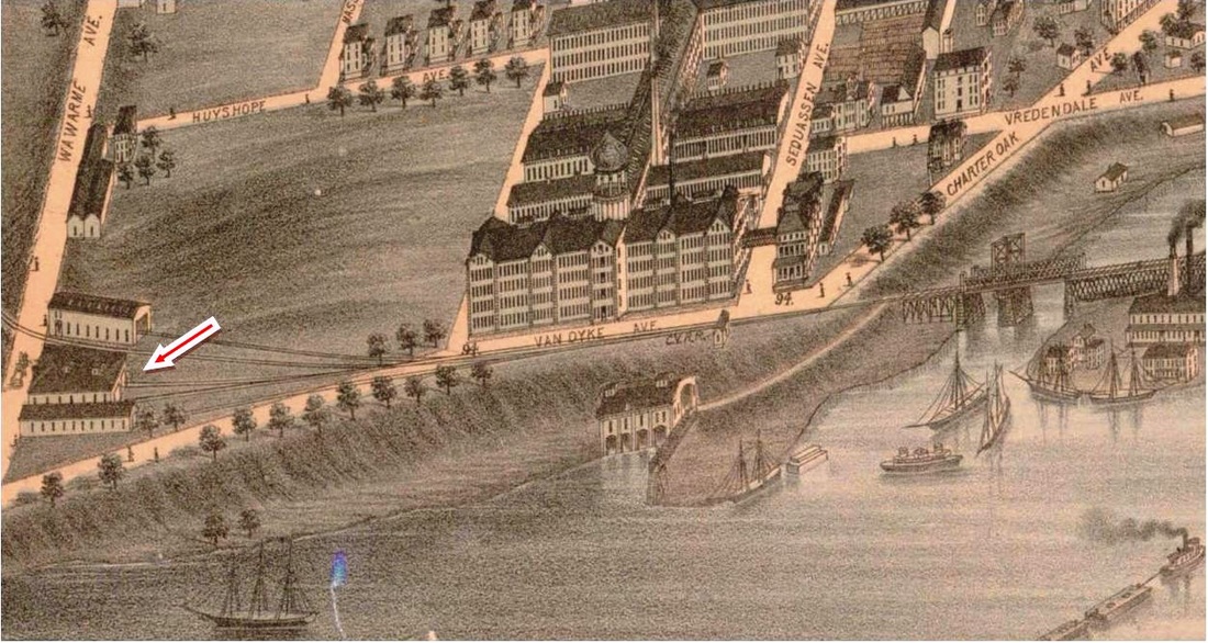
HARTFORD3 [CV, 1871]
This was the temporary CV station, called COLTS or DYKE, which apparently stood in front of the firearms factory at first. It was removed afterward and is seen as the middle building at the red arrow in the complex to the far left. The depot was described as being 163x32 feet in size and having three tracks going inside. Once the State St. terminus was established farther north early in 1872, the intention was to relocate the COLTS structure to the south dyke area and to use it as a car house in what became the the CV's first operations base in Hartford at Wawarme and Van Dyke Aves. Even though COLTS was not a timetable stop in later days, special trains continued to depart from here, as in August, 1872 when a Fenwick-bound excursion did so. This location was a still a NYNH&H freight station at least until 1925 and the spur to Brainard Airport and the Hartford produce terminal, installed in 1919 [RCM], still leaves the former CV main here today. This and the next shot are from the O.H. Bailey 1877 bird's-eye map of Hartford. [REFS: HDC/08/01/1871/02; HDC/10/03/1871/02; HC/01/13/1872/02; HDC/08/28/1872/02][rev010314]
This was the temporary CV station, called COLTS or DYKE, which apparently stood in front of the firearms factory at first. It was removed afterward and is seen as the middle building at the red arrow in the complex to the far left. The depot was described as being 163x32 feet in size and having three tracks going inside. Once the State St. terminus was established farther north early in 1872, the intention was to relocate the COLTS structure to the south dyke area and to use it as a car house in what became the the CV's first operations base in Hartford at Wawarme and Van Dyke Aves. Even though COLTS was not a timetable stop in later days, special trains continued to depart from here, as in August, 1872 when a Fenwick-bound excursion did so. This location was a still a NYNH&H freight station at least until 1925 and the spur to Brainard Airport and the Hartford produce terminal, installed in 1919 [RCM], still leaves the former CV main here today. This and the next shot are from the O.H. Bailey 1877 bird's-eye map of Hartford. [REFS: HDC/08/01/1871/02; HDC/10/03/1871/02; HC/01/13/1872/02; HDC/08/28/1872/02][rev010314]
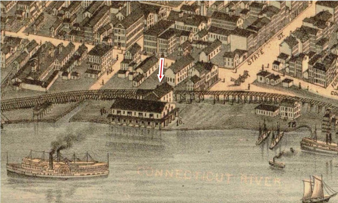
HARTFORD4 [CV, 1872]
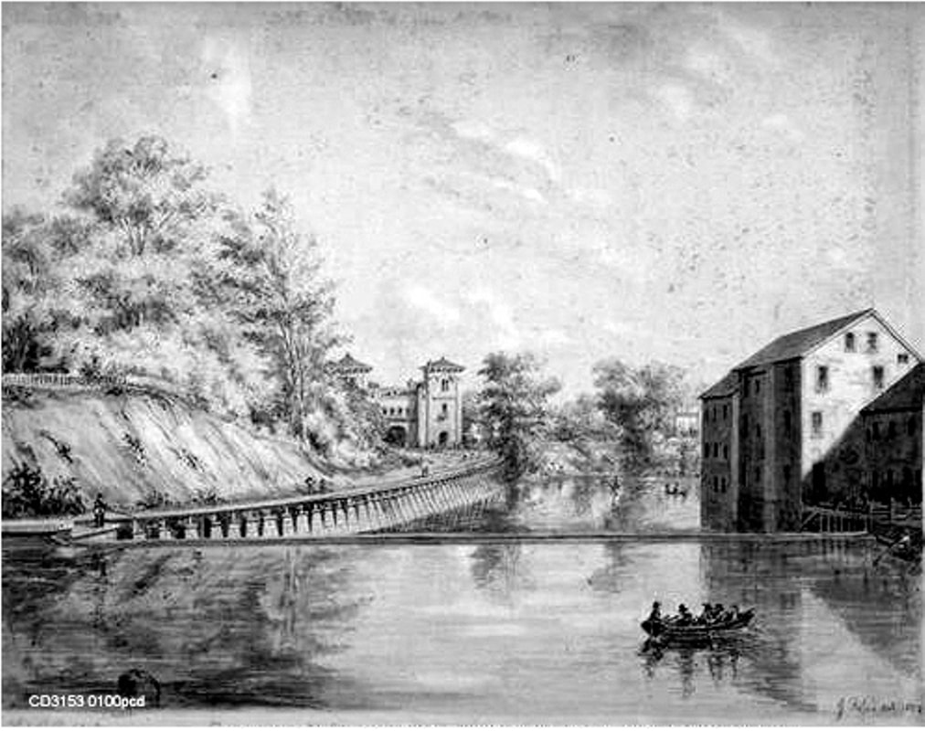
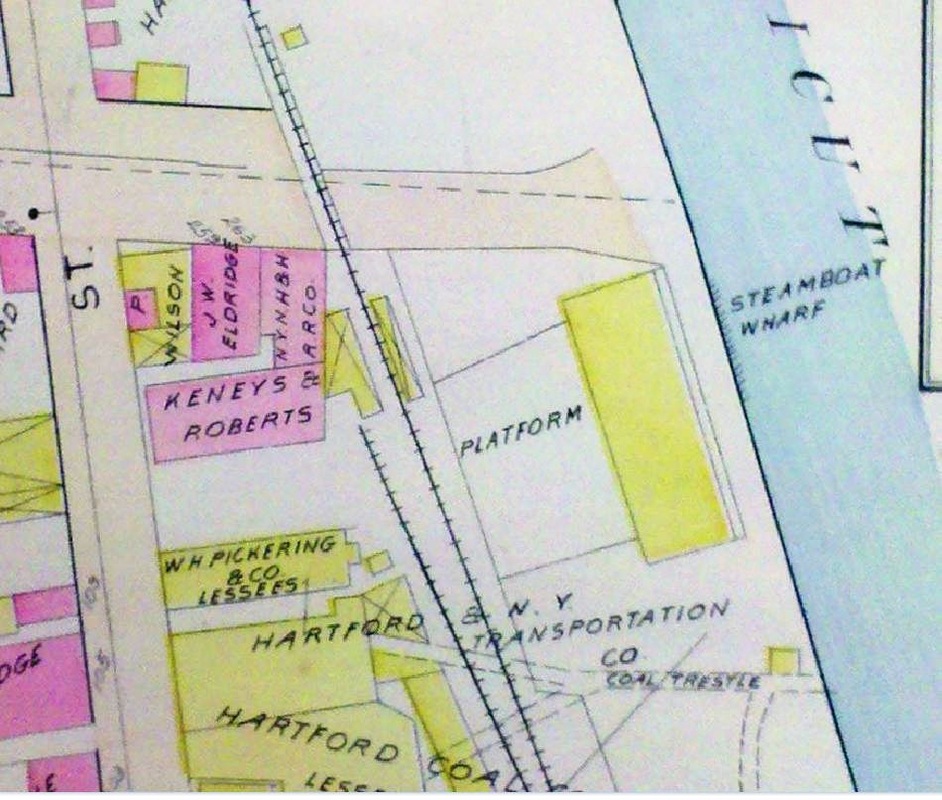
The depot at the steamboat dock, first used by the CV when it reached this point in January, 1872, is seen at locator number 16 on the map. The Hartford Weekly Times tells us that the railroad commissioners completed a 1/10/1872 inspection of the new trackage, which was mostly on pilings from Colt's Dyke to here, and noted "every post being morticed into the timbers which sustain the track bed." And further that "a very neat depot has been made at the foot of State street, by cutting the old freight house of the Hartford and New York Steamboat Company in two, and turning the halves side by side. There are large and convenient rooms for ladies and gentlemen, with a commodious ticket office between. They are warmed and ventilated, and easy of access from the foot of State street, two short flights of broad stairs leading from the street direct to the depot platform, which is built thus high to avoid the floods of Spring. In a few days trains will be running regularly to the State street depot." The side-by-side composition of the structure was either changed by the time Mr. Bailey was sketching for his map or it just was not that apparent from the outside. We do not see the stairs to the street either but we do note a passenger platform along the track to the left of the red arrow that points to the station building. The artist does realistically portray the pilings over the meadow south of the depot and the trestle supports to the north on this elevated portion of the CV. Many thanks to CNE rail historian Craig Michaelsen for sending us the HWT article! [REFS: HDC/01/13/1872/02; HWT/01/13/1872/02; HDC/03/24/1873/02; HDC/06/07/1873/02] [rev010314]
The depot at the steamboat dock, first used by the CV when it reached this point in January, 1872, is seen at locator number 16 on the map. The Hartford Weekly Times tells us that the railroad commissioners completed a 1/10/1872 inspection of the new trackage, which was mostly on pilings from Colt's Dyke to here, and noted "every post being morticed into the timbers which sustain the track bed." And further that "a very neat depot has been made at the foot of State street, by cutting the old freight house of the Hartford and New York Steamboat Company in two, and turning the halves side by side. There are large and convenient rooms for ladies and gentlemen, with a commodious ticket office between. They are warmed and ventilated, and easy of access from the foot of State street, two short flights of broad stairs leading from the street direct to the depot platform, which is built thus high to avoid the floods of Spring. In a few days trains will be running regularly to the State street depot." The side-by-side composition of the structure was either changed by the time Mr. Bailey was sketching for his map or it just was not that apparent from the outside. We do not see the stairs to the street either but we do note a passenger platform along the track to the left of the red arrow that points to the station building. The artist does realistically portray the pilings over the meadow south of the depot and the trestle supports to the north on this elevated portion of the CV. Many thanks to CNE rail historian Craig Michaelsen for sending us the HWT article! [REFS: HDC/01/13/1872/02; HWT/01/13/1872/02; HDC/03/24/1873/02; HDC/06/07/1873/02] [rev010314]
Connecticut Historical Society
|
|
|
|
|
Conn. Historical Society
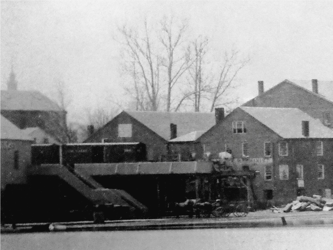
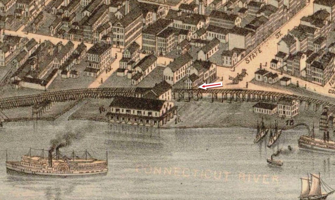
HARTFORD5 [CV, 1873]
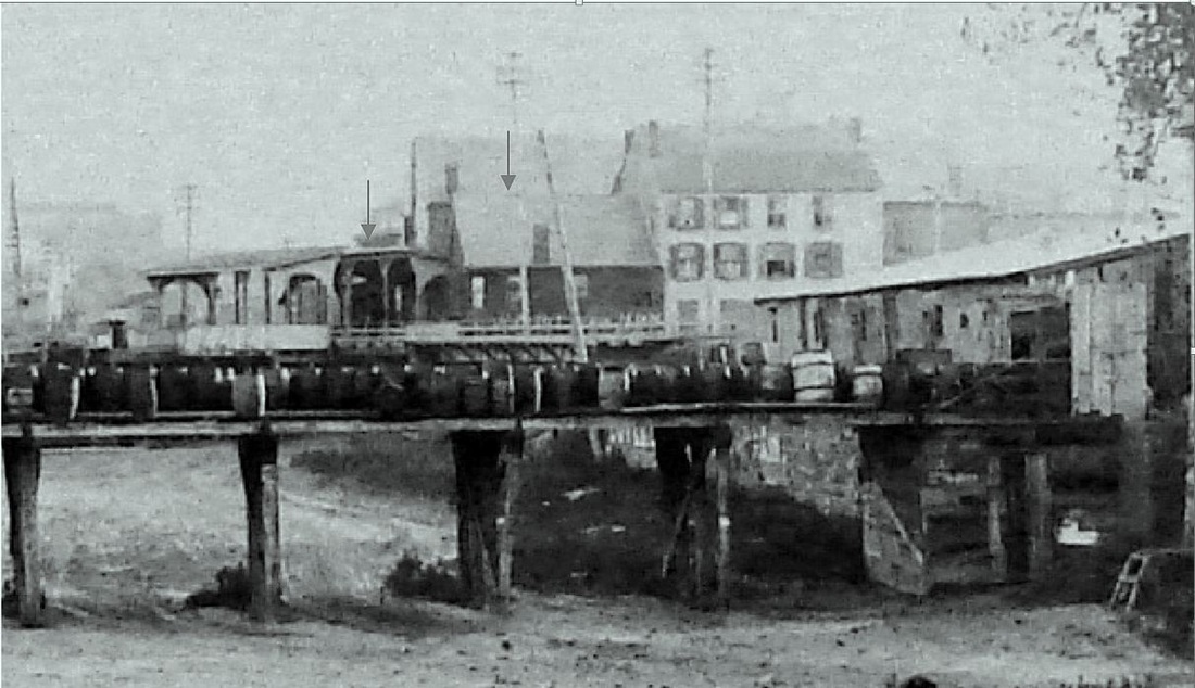
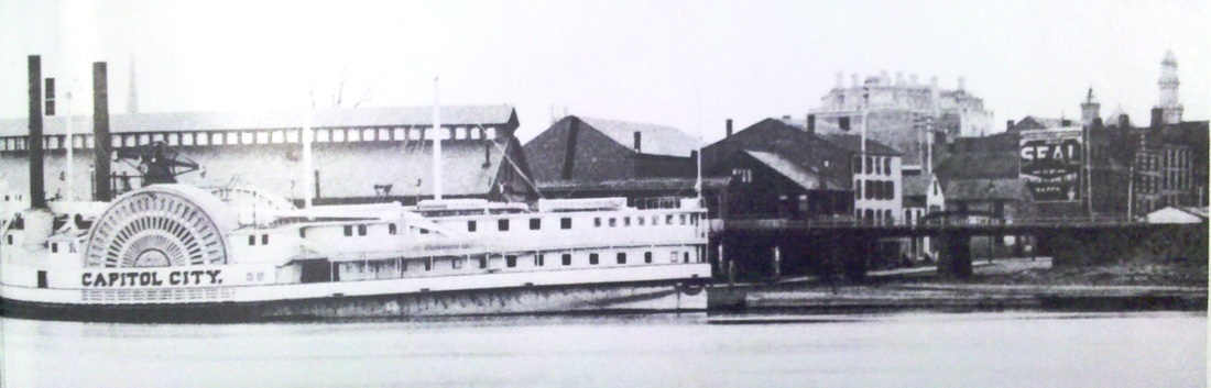
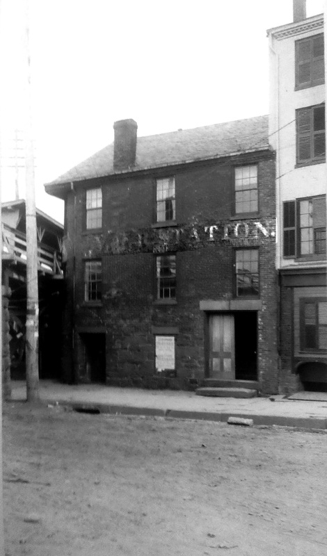
The photo at [1] shows the building that would become the CV depot for the next four decades, seemingly prior to its conversion in 1873 when the Middletown Constitution said "The Valley railroad company are cleaning out and remodeling the old brick building at the foot of State street and fitting it up for use as a temporary depot." Perhaps even more dramatic is that the photo shows box cars sitting on a trestle that dead-ends at State St. because a May, 1872 Courant article says that "a large number of workmen are engaged in the extension of the Valley road northward from its present depot. The track over State street will be supported by handsomely finished buttresses of Portland stone." Since we know that the CV reached State St. in January, 1872 and that by May of that same year they were building farther north to the junction with the HP&F/H&NH, we have a neatly delineated time frame for this historic photograph. CV trains would run to Union Station from 1872 until March, 1876, at which time, the railroad commissioners said that the CV had "abandoned" Union Station in favor of building a passenger depot at the foot of State St. While the 'abandonment' was reported correctly, the building never took place since the Courant said in 1907 that the old brick structure, which dated back to 1835, had been used as the CV depot "for nearly forty years." The article went on to say that the landmark, whose street-level tavern was frequented in the old days by Commodore Vanderbilt when he sailed ships to Hartford, had been torn down "several weeks ago," putting that event around April 3, 1907 when the new State St. station, HARTFORD11, opened. The demolition was said to be no great loss, since the depot's "dark and gloomy room" reportedly saw few patrons by that time. The 1877 Bailey map at [2] shows the building at the red arrow and the 1880 map at [3] shows the layout of the property that is prematurely attributed to the NYNH&H, which would not control the CV until 1882. The photo at [4] shows the building and the canopies [gray arrows] on both sides of the elevated track and the image at [5] captures the Capitol City at the steamboat dock. The photo at [6], perhaps ca. 1900, shows 'CVRR Station' in faded lettering. [REFS: HDC/05/10/1872/02; CR/09/28/1872/03; MC/06/04/1873/02; HDC/06/07/1873/02; HDC/06/09/1873/02; MC/06/11/1873/02; HDC/12/23/1873/02; HDC/03/13/1876/02; CRC23.1876.4; HDC/05/19/1880/02; HC/04/23/1907/03; HC/05/15/1907/15; K98] [rev010314, rrd051419, rev012723]
The photo at [1] shows the building that would become the CV depot for the next four decades, seemingly prior to its conversion in 1873 when the Middletown Constitution said "The Valley railroad company are cleaning out and remodeling the old brick building at the foot of State street and fitting it up for use as a temporary depot." Perhaps even more dramatic is that the photo shows box cars sitting on a trestle that dead-ends at State St. because a May, 1872 Courant article says that "a large number of workmen are engaged in the extension of the Valley road northward from its present depot. The track over State street will be supported by handsomely finished buttresses of Portland stone." Since we know that the CV reached State St. in January, 1872 and that by May of that same year they were building farther north to the junction with the HP&F/H&NH, we have a neatly delineated time frame for this historic photograph. CV trains would run to Union Station from 1872 until March, 1876, at which time, the railroad commissioners said that the CV had "abandoned" Union Station in favor of building a passenger depot at the foot of State St. While the 'abandonment' was reported correctly, the building never took place since the Courant said in 1907 that the old brick structure, which dated back to 1835, had been used as the CV depot "for nearly forty years." The article went on to say that the landmark, whose street-level tavern was frequented in the old days by Commodore Vanderbilt when he sailed ships to Hartford, had been torn down "several weeks ago," putting that event around April 3, 1907 when the new State St. station, HARTFORD11, opened. The demolition was said to be no great loss, since the depot's "dark and gloomy room" reportedly saw few patrons by that time. The 1877 Bailey map at [2] shows the building at the red arrow and the 1880 map at [3] shows the layout of the property that is prematurely attributed to the NYNH&H, which would not control the CV until 1882. The photo at [4] shows the building and the canopies [gray arrows] on both sides of the elevated track and the image at [5] captures the Capitol City at the steamboat dock. The photo at [6], perhaps ca. 1900, shows 'CVRR Station' in faded lettering. [REFS: HDC/05/10/1872/02; CR/09/28/1872/03; MC/06/04/1873/02; HDC/06/07/1873/02; HDC/06/09/1873/02; MC/06/11/1873/02; HDC/12/23/1873/02; HDC/03/13/1876/02; CRC23.1876.4; HDC/05/19/1880/02; HC/04/23/1907/03; HC/05/15/1907/15; K98] [rev010314, rrd051419, rev012723]

Connecticut Historical Society
HARTFORD6 [NYNH&H, 1887]
The structure at the red arrow looks likely to have been what was used on the NYNH&H side of Union Place in 1888 and 1889 with after the demolition of HARTFORD2 that began on 5/30/1887. This temporary station was reportedly built with trusses from the old Adams Express shed [see above: HARTFORD2, photo 5] and it was expected to open on 5/22/1887. The CHS image shows the work site probably just after the demolition of the old depot was completed, with steam hammers already pounding pilings into the ground for the new station, HARTFORD8, that would open on 5/2/1889. Pass-around tracks were built east and west of the site while construction was going on. HARTFORD6 was demolished on 5/6/1889 with locomotives helping to pull it down. [REFS: HDC/04/26/1887/02; HDC/05/18/1887/02; HDC/05/30/1887/02; HDC/05/07/1889/08]
The structure at the red arrow looks likely to have been what was used on the NYNH&H side of Union Place in 1888 and 1889 with after the demolition of HARTFORD2 that began on 5/30/1887. This temporary station was reportedly built with trusses from the old Adams Express shed [see above: HARTFORD2, photo 5] and it was expected to open on 5/22/1887. The CHS image shows the work site probably just after the demolition of the old depot was completed, with steam hammers already pounding pilings into the ground for the new station, HARTFORD8, that would open on 5/2/1889. Pass-around tracks were built east and west of the site while construction was going on. HARTFORD6 was demolished on 5/6/1889 with locomotives helping to pull it down. [REFS: HDC/04/26/1887/02; HDC/05/18/1887/02; HDC/05/30/1887/02; HDC/05/07/1889/08]
Connecticut Historical Society
HARTFORD7 [NY&NE, 1887]
We did not even know there was a separate NY&NE temporary station while HARTFORD8 was being built until we found some articles in the Courant. So when we looked at this photo again and realized that there was nothing here at the red arrow before HARTFORD2 was torn down, it seemed likely that this is HARTFORD7, shared by the CW that came in from just where the curve swings off to the upper right in the distance. An article in May said "The temporary station in Spruce street for the use of the New England and Connecticut Western roads is being erected as rapidly as possible." A fire in the temporary depot in December, 1887 is noted in the paper which says repairs had been made. [REFS: HDC/05/26/1887/02; HDC/12/01/1887/08; BA42.1889.00: fire on 12/2/1887][rev123112, rrd051419]
We did not even know there was a separate NY&NE temporary station while HARTFORD8 was being built until we found some articles in the Courant. So when we looked at this photo again and realized that there was nothing here at the red arrow before HARTFORD2 was torn down, it seemed likely that this is HARTFORD7, shared by the CW that came in from just where the curve swings off to the upper right in the distance. An article in May said "The temporary station in Spruce street for the use of the New England and Connecticut Western roads is being erected as rapidly as possible." A fire in the temporary depot in December, 1887 is noted in the paper which says repairs had been made. [REFS: HDC/05/26/1887/02; HDC/12/01/1887/08; BA42.1889.00: fire on 12/2/1887][rev123112, rrd051419]
|
|
|
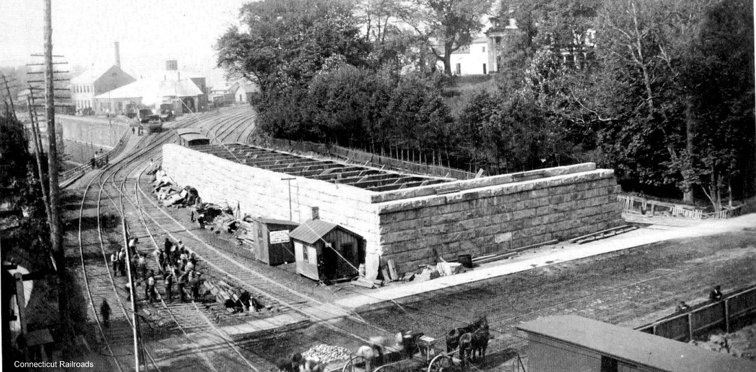
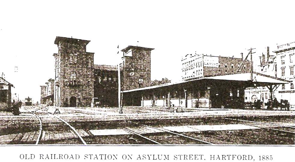
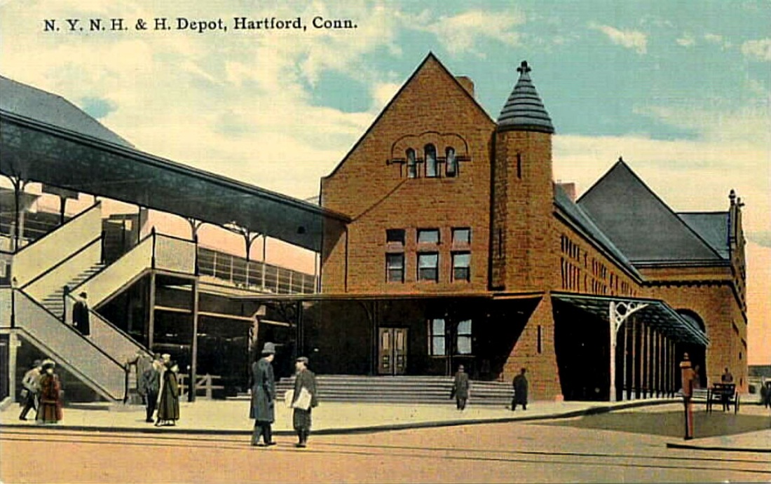
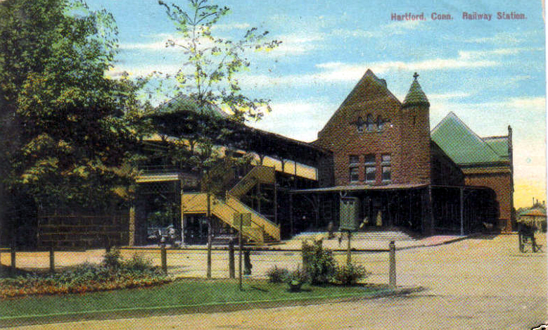
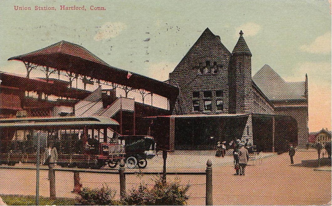
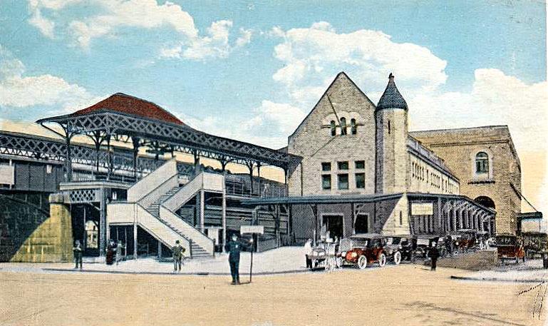
HARTFORD8 [NYNH&H, 1889]
The building of this elevated station was a result of the city's insistence on the elimination of the dangerous, multi-track grade crossing on Asylum St. Construction began on 4/18/1887, it went into partial use on 5/5/1889 and it opened officially on 7/1/1889. The photo at lower left shows the elevation work for the tracks from the west underway prior to May, 1889 when some Consolidated trains first began to run into the new station. The postcard at [3] reportedly dates to 1912. Note the high, cross-gabled roof over the central part of the station in the distance on the east side of the building. In the distance in the construction shot at [4] are the old H&NH engine house and shops.
The building of this elevated station was a result of the city's insistence on the elimination of the dangerous, multi-track grade crossing on Asylum St. Construction began on 4/18/1887, it went into partial use on 5/5/1889 and it opened officially on 7/1/1889. The photo at lower left shows the elevation work for the tracks from the west underway prior to May, 1889 when some Consolidated trains first began to run into the new station. The postcard at [3] reportedly dates to 1912. Note the high, cross-gabled roof over the central part of the station in the distance on the east side of the building. In the distance in the construction shot at [4] are the old H&NH engine house and shops.
|
|
|
|

Edward J. Ozog Collection
|

|
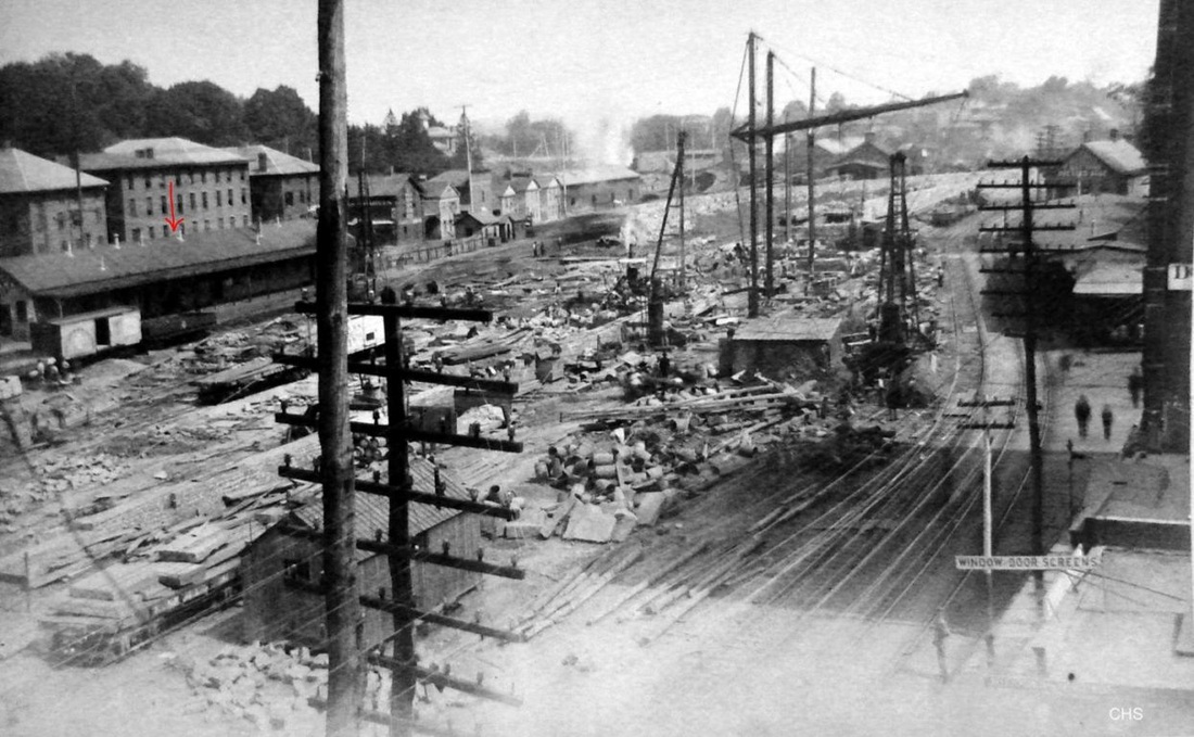
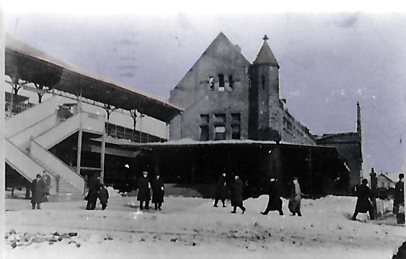
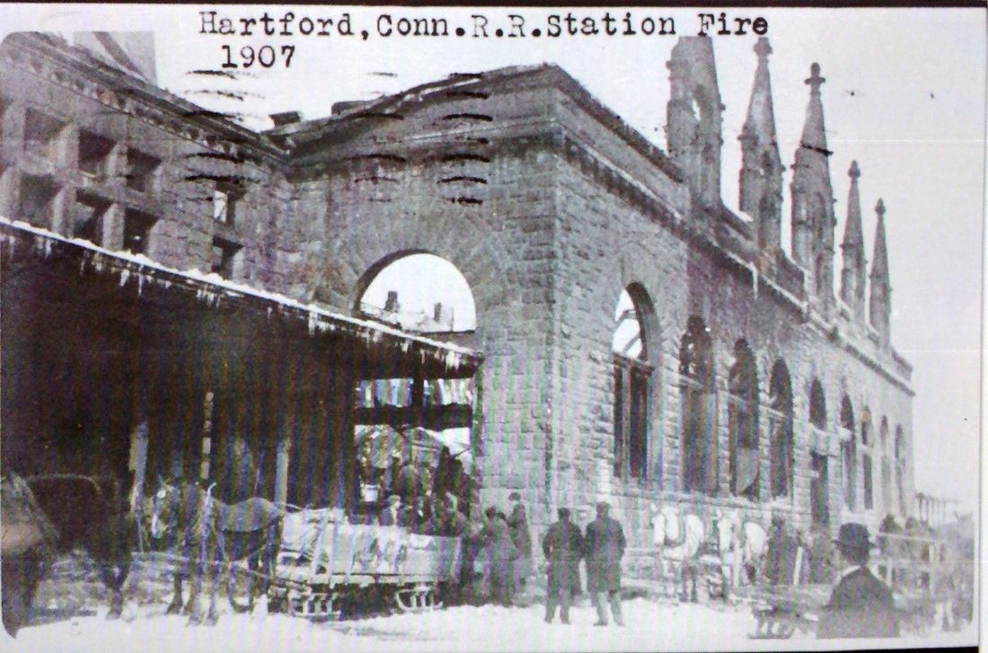
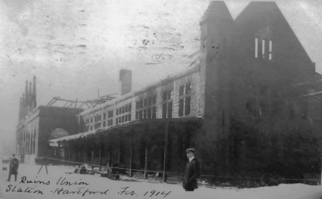
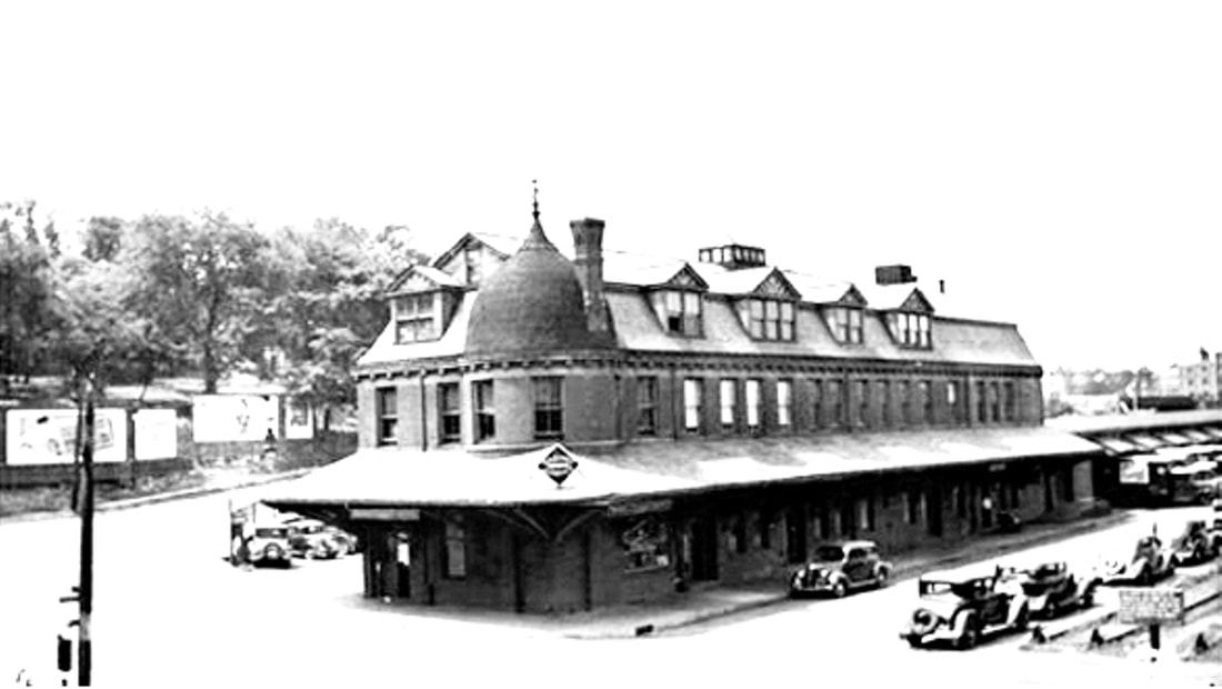
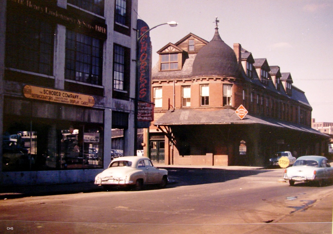
A fire on 2/21/1914, caused by an overturned oil stove in the Adams Express Co. office, necessitated an expensive and extensive rebuild for HARTFORD8. Three fire photos are seen on the top row in the lower group; 1907 date is in error. A temporary station, HARTFORD11 [see below] was begun immediately on the Spruce St. (west) side of the damaged station to be used by southbound passengers and opened on 2/24. The street-level restaurant, with only smoke and water damage, was to be used for northbound passengers while it was decided what to do after the fire. Disliked for its limitations and the “mazes of [the] ancient structure" that were said to be a "labyrinth to the uninitiated,” the station was never a popular building. A group from Hartford visited President Mellen to discuss plans for reconstructing it in a better manner and perhaps choosing a new location entirely. Mellen reportedly said that in his opinion the “Hartford railroad station was the worst abortion on the road between New York and Boston” but, in spite of this sentiment, the NYNH&H decided to rebuild using the walls of the old structure, which were deemed sound. Interestingly, the newspapers mentioned the need for the old station plans, said to have been imported from Hanover, Germany ca. 1880, to be found down in New Haven to see what had to be changed to meet the current Hartford building code. Apparently this was done and the station was rebuilt, with the former cross-gabled roof replaced by a flat, steel fireproof covering instead, noticeable in the photo at bottom left, with an image of the burned-out structure just above it. Though the station reopened officially on 9/27/1915, it should be noted that all train service continued in the interim, even using the tracks on the eastbound side immediately after the fire was put out. The paper noted that the Valley, Connecticut Western (CNE) and Connecticut Central trains were still terminating here at Union Station, by now all as branches of the NYNH&H. The card at [4] looks north and the image at [5] shows the interior. The shot as [6] looks east at the covered walkways up to the elevated station. Comparing the rebirth to the of the phoenix rising in Classical mythology, the Courant said it was pleased with the changes and invited New Haven people up to see the new station here and compare it to their old "antique," NEW HAVEN4, that would not be replaced until 1920. The teasing sentiment showed that the rivalry between the old capital cities that dated back to the 1700s was still in vogue over two centuries later. [REFS: HDC/04/18/1887/03; HDC/05/02/1889/08; CRC38.1890.52; HC/02/22/1914/01,10; HC/02/23/1914/02; HC/03/14/1914/04; HC/09/27/1915/05][rev090512, rrd051419, rev012723]

|
|
|
HARTFORD9 [H&CW, 1889]
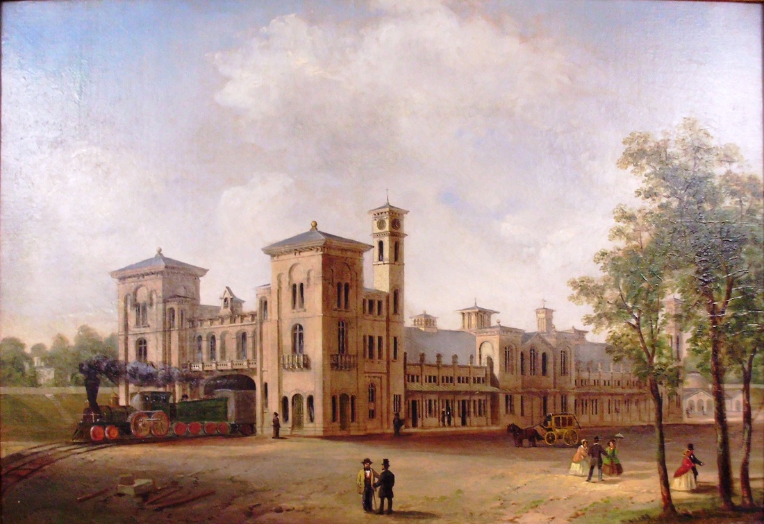
This station was in some ways the result of the elevated level of the new HARTFORD8 station. While there was still a track connection further to the north, HC&W access to Union Station was impractical, unnecessary and, with the landlord being the NYNH&H, expensive. The HC&W, therefore, decided to build a depot of its own at Spruce and Church Sts., northwest of the new Union Station. The $16,000 contract was let on 3/4/1889 and the station opened on the scheduled date of July 1, though still somewhat incomplete. The architect was Brooks W. Lincoln and the builder was H.W. Fox & Co. of Hartford. The handsome, two-story structure had space for the company's offices on the upper level. The building sported a Turkish-style minaret in the southeast corner and the gambrel roof was punctuated by dormers, altogether a uniquely stylish station and railroad headquarters. The H&CW's next annual meeting took place in the new station where the lease to the CNE&W was approved on 3/14/1890. References to a Walnut St. station, that street being on the northern and eastern boundary of the railroad's property, appear to mean this depot, though it was a good distance away from that street. Under the NYNH&H, this station was given over the Railway Express Agency use in the 1920s and continued in that capacity until 1961. A Courant newspaper article then said that REA service was being transferred to East Hartford's former NETCo facility, which coincidentally had no rail spur, truck pickups being made from the Morgan St. freight house. The old station surrendered to the wrecker's ball thereafter, since it "was in the path of the new East-West Highway" that we know today as I-84. The image at [1] shows CNE #8 on the street side of the station. The photo at [2] looks to be from the 1930s and the shot at [3] from the 1950s just prior to the razing. [REFS: HC/08/17/1888/05; HC/03/05/1889/05; NHER/03/06/1889/04; HC/07/01/1889/01; HWT/07/03/1889/08; NHER/12/14/1889/01; HC/03/15/1890/01; HC/08/31/1961/20A][rev110815, rrd051419, rev012723]
This station was in some ways the result of the elevated level of the new HARTFORD8 station. While there was still a track connection further to the north, HC&W access to Union Station was impractical, unnecessary and, with the landlord being the NYNH&H, expensive. The HC&W, therefore, decided to build a depot of its own at Spruce and Church Sts., northwest of the new Union Station. The $16,000 contract was let on 3/4/1889 and the station opened on the scheduled date of July 1, though still somewhat incomplete. The architect was Brooks W. Lincoln and the builder was H.W. Fox & Co. of Hartford. The handsome, two-story structure had space for the company's offices on the upper level. The building sported a Turkish-style minaret in the southeast corner and the gambrel roof was punctuated by dormers, altogether a uniquely stylish station and railroad headquarters. The H&CW's next annual meeting took place in the new station where the lease to the CNE&W was approved on 3/14/1890. References to a Walnut St. station, that street being on the northern and eastern boundary of the railroad's property, appear to mean this depot, though it was a good distance away from that street. Under the NYNH&H, this station was given over the Railway Express Agency use in the 1920s and continued in that capacity until 1961. A Courant newspaper article then said that REA service was being transferred to East Hartford's former NETCo facility, which coincidentally had no rail spur, truck pickups being made from the Morgan St. freight house. The old station surrendered to the wrecker's ball thereafter, since it "was in the path of the new East-West Highway" that we know today as I-84. The image at [1] shows CNE #8 on the street side of the station. The photo at [2] looks to be from the 1930s and the shot at [3] from the 1950s just prior to the razing. [REFS: HC/08/17/1888/05; HC/03/05/1889/05; NHER/03/06/1889/04; HC/07/01/1889/01; HWT/07/03/1889/08; NHER/12/14/1889/01; HC/03/15/1890/01; HC/08/31/1961/20A][rev110815, rrd051419, rev012723]

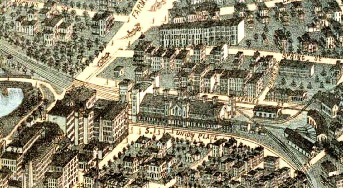
HARTFORD10 [NY&NE, 1893]
This was the NY&NE station on Spruce St. It was built on land still owned by the company after disagreements over rent and access at the NYNH&H's HARTFORD8 surfaced and alienated the two roads. A May, 1893 newspaper article said the exterior was almost complete, the outside walls covered with metal shingles or plates "called the Cartwright roofing, and painted brown." Additionally, it is described as a two-story structure with a large waiting room and ticket office on the "platform floor," i.e. track level, and baggage and express department at street level serviced from above by a freight elevator. The restaurant was to be run by "Parker" as was done for the NY&NE in Boston, Putnam, and Willimantic. The 1893 NY&NE annual report said it cost $8,500 and, somewhat cryptically, that it was "of a temporary nature, but is convenient and will serve all necessary purposes for some time to come." We have yet to find a photo of this station, but the Sanborn map posted here at least shows the footprint of the structure. The Consolidated objected to this move by the NY&NE, claiming that the wooden structure would be a fire hazard. Ironically, the NYNH&H's own brownstone station would be gutted by fire in 1914. [REFS: NYNEAR18.1894.8; DEN/01/03/1893/04; HC/04/25/1893/01; HC/05/09/1893/02; HC/10/08/1895/01]
This was the NY&NE station on Spruce St. It was built on land still owned by the company after disagreements over rent and access at the NYNH&H's HARTFORD8 surfaced and alienated the two roads. A May, 1893 newspaper article said the exterior was almost complete, the outside walls covered with metal shingles or plates "called the Cartwright roofing, and painted brown." Additionally, it is described as a two-story structure with a large waiting room and ticket office on the "platform floor," i.e. track level, and baggage and express department at street level serviced from above by a freight elevator. The restaurant was to be run by "Parker" as was done for the NY&NE in Boston, Putnam, and Willimantic. The 1893 NY&NE annual report said it cost $8,500 and, somewhat cryptically, that it was "of a temporary nature, but is convenient and will serve all necessary purposes for some time to come." We have yet to find a photo of this station, but the Sanborn map posted here at least shows the footprint of the structure. The Consolidated objected to this move by the NY&NE, claiming that the wooden structure would be a fire hazard. Ironically, the NYNH&H's own brownstone station would be gutted by fire in 1914. [REFS: NYNEAR18.1894.8; DEN/01/03/1893/04; HC/04/25/1893/01; HC/05/09/1893/02; HC/10/08/1895/01]

Hartford Courant
|
|

|
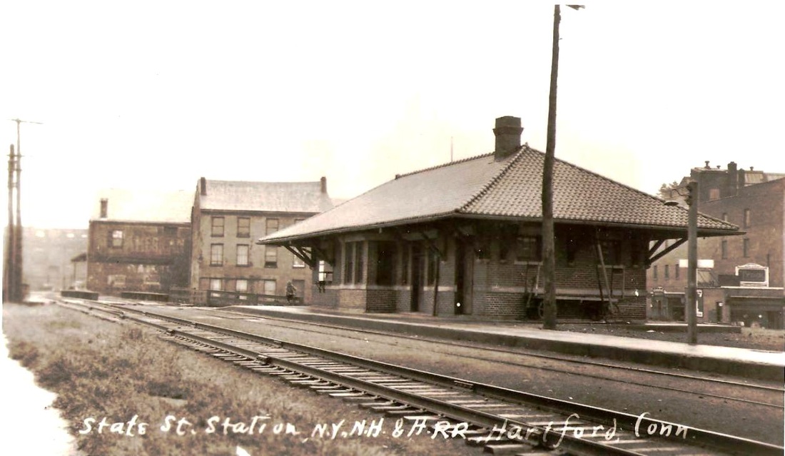
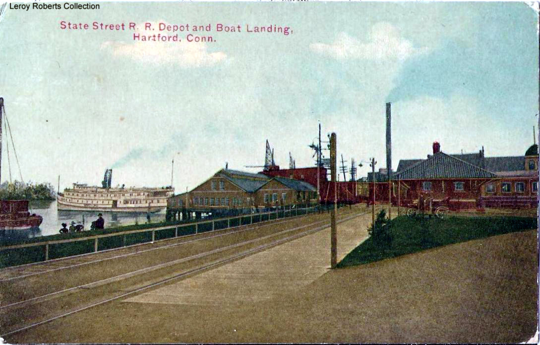
HARTFORD11 [NYNH&H, 1907]
This station would replace HARTFORD5 at the foot of State St. It came about as part of the improvements underway in 1905 which included the creation of the Connecticut Boulevard that began here and ran along the river up to the new 1908 Bulkeley Bridge that crossed the river to East Hartford. The newspaper reported that the new 69x21-ft depot had a brick and granite exterior, a red tile roof, and an eight-foot overhang all around. Inside were men's and women's waiting rooms with a small baggage room on the north end. Since this structure sat at a higher elevation after the old CV trestle work had been filled in, a stairway led up from State St. up to the station which figured as something of gateway on the boardwalk that also ran north to Riverside Park. All these new amenities contributed to increased use of this station now that the dreary old HARTFORD5 was gone. The postcard above highlights the closeness of rail access to the steamboats. Water transportation, also largely controlled by the NYNH&H by the early 1900s, was still important for freight and passenger service and Hartford continued to greatly overshadow all the other Connecticut ports including New Haven where Long Wharf was already in decline. Another round of highway improvements in the form of a State St. bridge to East Hartford would doom this station, which was still standing in 1955. Dunn Bros., an East Hartford contractor, was the low bidder for the demolition work, reportedly offering to do the job for $460. Passenger service on the Valley branch had ceased in 1933 according to Karr so the station structure, however handsome when built, had languished unused for 20 years by the time the wrecker's ball swung. The Courant newspaper photo at [1] appears to look east. The view on the card at [2] looks north. The ICC valuation photo at [3] looks to be dated 8/16/1917. The image at [4] is Lewis H. Benton's number 2149, taken in 1928, likely on 6/24. [REFS: NHAR36.1907.5; HC/05/15/1907/15; HC/05/31/1907/04; HC/05/11/1955/02; K98][rev032113, 051419, 012723]
This station would replace HARTFORD5 at the foot of State St. It came about as part of the improvements underway in 1905 which included the creation of the Connecticut Boulevard that began here and ran along the river up to the new 1908 Bulkeley Bridge that crossed the river to East Hartford. The newspaper reported that the new 69x21-ft depot had a brick and granite exterior, a red tile roof, and an eight-foot overhang all around. Inside were men's and women's waiting rooms with a small baggage room on the north end. Since this structure sat at a higher elevation after the old CV trestle work had been filled in, a stairway led up from State St. up to the station which figured as something of gateway on the boardwalk that also ran north to Riverside Park. All these new amenities contributed to increased use of this station now that the dreary old HARTFORD5 was gone. The postcard above highlights the closeness of rail access to the steamboats. Water transportation, also largely controlled by the NYNH&H by the early 1900s, was still important for freight and passenger service and Hartford continued to greatly overshadow all the other Connecticut ports including New Haven where Long Wharf was already in decline. Another round of highway improvements in the form of a State St. bridge to East Hartford would doom this station, which was still standing in 1955. Dunn Bros., an East Hartford contractor, was the low bidder for the demolition work, reportedly offering to do the job for $460. Passenger service on the Valley branch had ceased in 1933 according to Karr so the station structure, however handsome when built, had languished unused for 20 years by the time the wrecker's ball swung. The Courant newspaper photo at [1] appears to look east. The view on the card at [2] looks north. The ICC valuation photo at [3] looks to be dated 8/16/1917. The image at [4] is Lewis H. Benton's number 2149, taken in 1928, likely on 6/24. [REFS: NHAR36.1907.5; HC/05/15/1907/15; HC/05/31/1907/04; HC/05/11/1955/02; K98][rev032113, 051419, 012723]
Dave Peters Collection
|

|
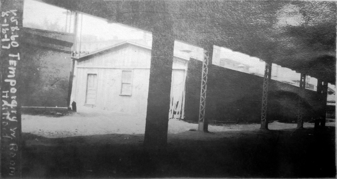
HARTFORD12 [NYNH&H, 1914]
With its 1917 date and marked as 'Temporary W[estbound] room, Hartford', this must have been the structure used when HARTFORD8 was out of commission after the 2/21/1914 fire. Work started the day of the fire for the building that was put up on the Spruce St. side of the tracks and it was opened within two days of the conflagration. It is hard to imagine that this nondescript structure would still be standing in a busy downtown area two years after HARTFORD8 reopened on 9/27/1915, but the 8/16/1917 ICC valuation photo proves that it was. Perhaps, it served some freight or express purpose in the meantime. The image at right appeared in the newspaper when the temporary station was being put up. [REFS: HC/02/23/1914/01][rev051419, 012723]
With its 1917 date and marked as 'Temporary W[estbound] room, Hartford', this must have been the structure used when HARTFORD8 was out of commission after the 2/21/1914 fire. Work started the day of the fire for the building that was put up on the Spruce St. side of the tracks and it was opened within two days of the conflagration. It is hard to imagine that this nondescript structure would still be standing in a busy downtown area two years after HARTFORD8 reopened on 9/27/1915, but the 8/16/1917 ICC valuation photo proves that it was. Perhaps, it served some freight or express purpose in the meantime. The image at right appeared in the newspaper when the temporary station was being put up. [REFS: HC/02/23/1914/01][rev051419, 012723]
HARWINTON [> LITCHFIELD1]
|
|
Newtown Historical Society
|
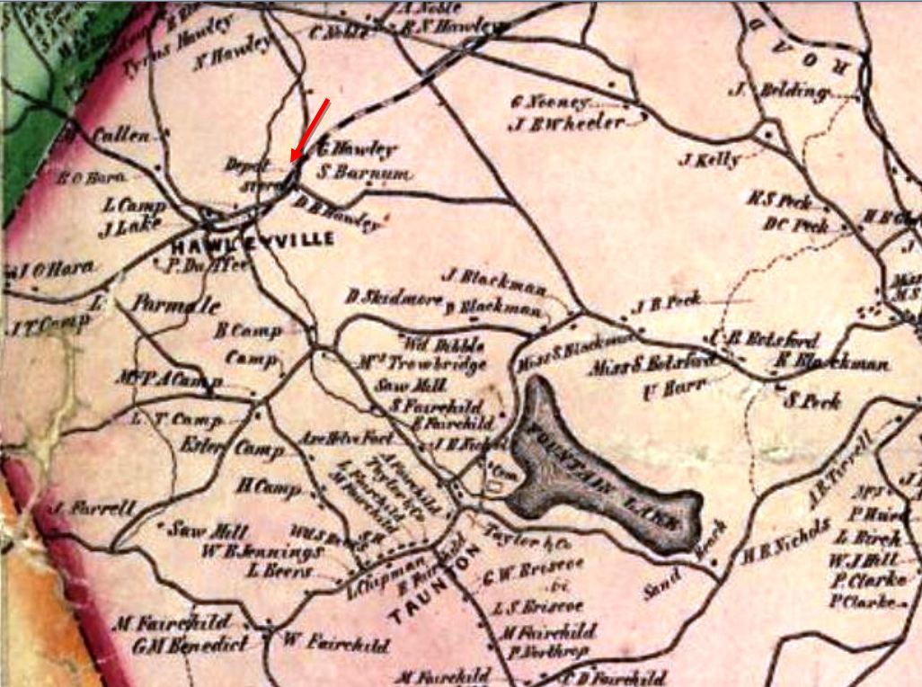
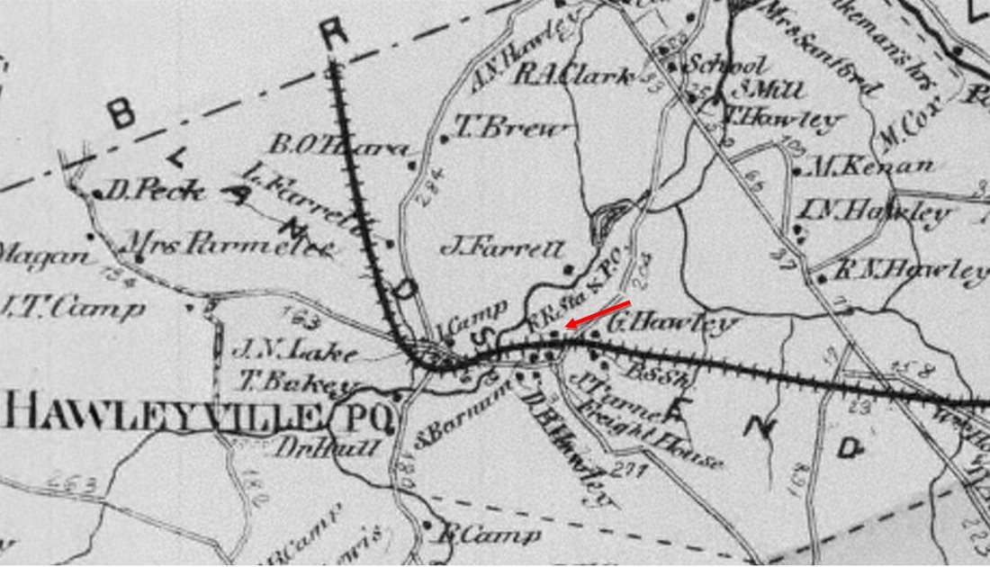
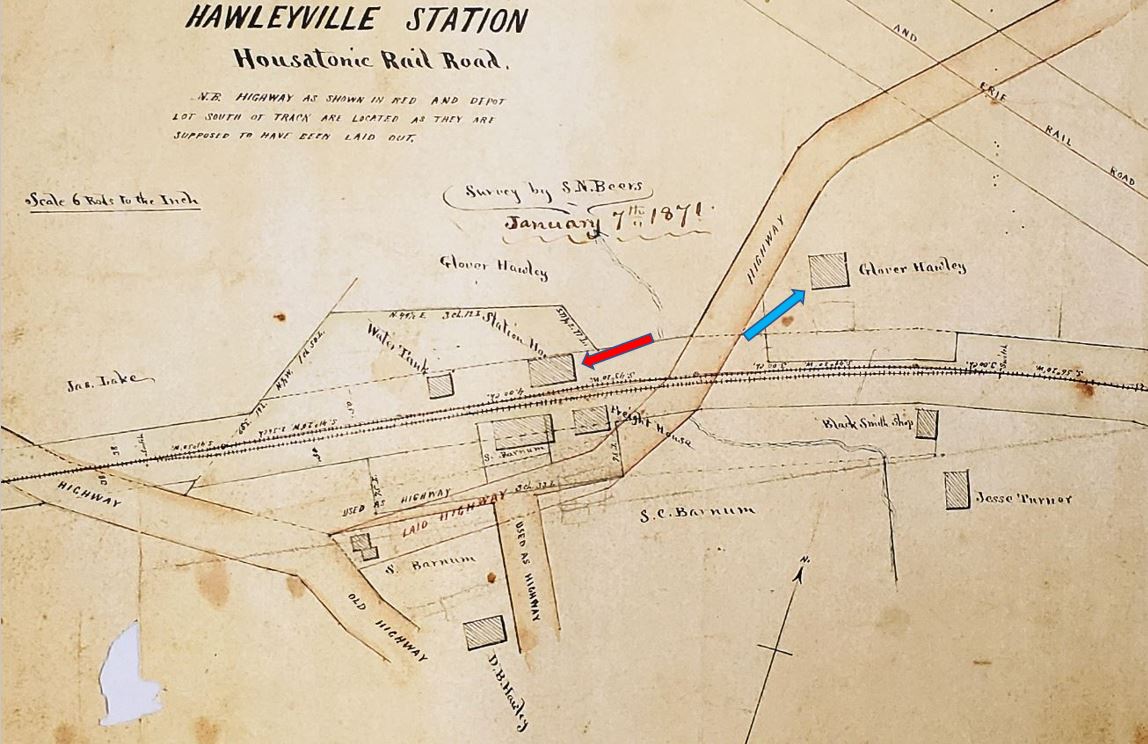
HAWLEYVILLE1 [HRR, 1840]
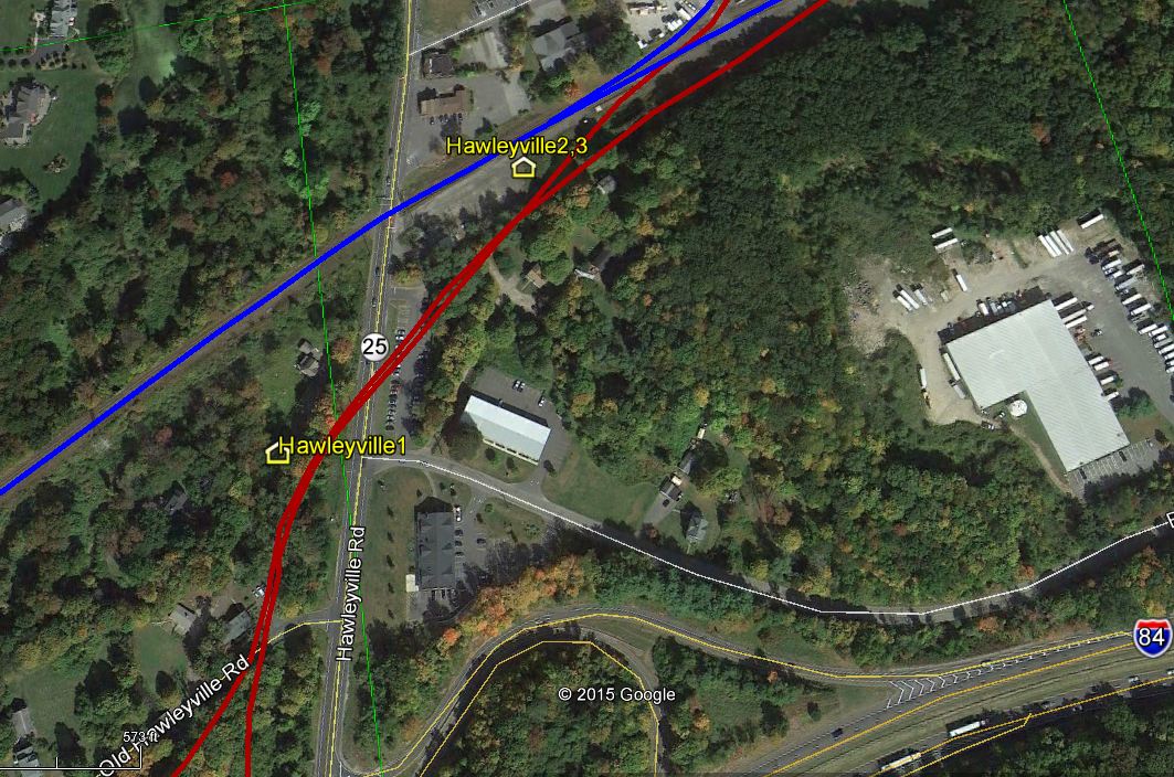
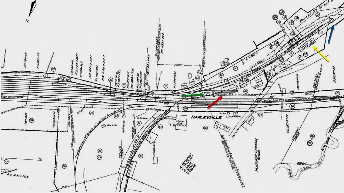
The 1840 opening schedule shows this stop in the town of Newtown listed as LAND'S END which harkens back to the early settlers acknowledging this as the end of their allotted property. As the 1856FC map at [1] shows, the first station here was west of today's Rte. 25 and stood on the north side of the original HRR track. This location is a few hundred feet south of today's railroad line which the NY&NE put through in 1881. By 1867 the Beers map at [2] shows a freight house south of the track. The best detail is given in the recently found 1/7/1871 map at [3]. The passenger station is at our red arrow and a square water tank stands just to the west. R&LHS records at the Baker Library show that Abel Drew received $25.00 on 6/25/1840 for building the tank; he may have also constructed the depot buildings. The Litchfield Republican newspaper is the first we have found to indicate a structure, saying that Gov. Seymour and "his associate State Officers... were met at the Rail road depot at Hawleyville" in 1850 to attend to funeral of Hiram Weed, secretary of the state. Glover Hawley, a prominent local resident, owned land that both the HRR and the later BH&E would purchase for railroad use. According to Beers, he was one of the "warmest supporters" of the railroad and he "piloted the surveyors through this part of the town, and gave the right of way over a quarter of a mile through his farm, also the land for the necessary depot buldings..." The 'gave' is undoubtedly euphemistic: R&LHS notes say he received $550 for a deed to "land & buildings" in 1856, perhaps for some HRR expansion at that time. We have no photo yet of HAWLEYVILLE1 which the maps show stood across the street from Hawley's house [3, blue arrow]. Perhaps it was due to him that such purpose-built structures were erected here, whereas elsewhere, e.g. STEPNEY, MERWINSVILLE, and CANAAN, the early HRR rented passenger space. Exactly how long this depot complex was in use is unclear; by 1881 all of the railroads would be sharing HAWLEYVILLE3. The Track 11 Google Earth snippet at [4] shows where HAWLEYVILLE1 stood. One of Hawley's initial conditions was that the stop be named after his family and so it came to be that the locale has been known as such for 170 years. [REFS: LR/06/20/1850/02; J.H. Beers, Commemorative Biographical Record of Fairfield County, Connecticut (1899), p1291; B774; rev080515, 060622]
The 1840 opening schedule shows this stop in the town of Newtown listed as LAND'S END which harkens back to the early settlers acknowledging this as the end of their allotted property. As the 1856FC map at [1] shows, the first station here was west of today's Rte. 25 and stood on the north side of the original HRR track. This location is a few hundred feet south of today's railroad line which the NY&NE put through in 1881. By 1867 the Beers map at [2] shows a freight house south of the track. The best detail is given in the recently found 1/7/1871 map at [3]. The passenger station is at our red arrow and a square water tank stands just to the west. R&LHS records at the Baker Library show that Abel Drew received $25.00 on 6/25/1840 for building the tank; he may have also constructed the depot buildings. The Litchfield Republican newspaper is the first we have found to indicate a structure, saying that Gov. Seymour and "his associate State Officers... were met at the Rail road depot at Hawleyville" in 1850 to attend to funeral of Hiram Weed, secretary of the state. Glover Hawley, a prominent local resident, owned land that both the HRR and the later BH&E would purchase for railroad use. According to Beers, he was one of the "warmest supporters" of the railroad and he "piloted the surveyors through this part of the town, and gave the right of way over a quarter of a mile through his farm, also the land for the necessary depot buldings..." The 'gave' is undoubtedly euphemistic: R&LHS notes say he received $550 for a deed to "land & buildings" in 1856, perhaps for some HRR expansion at that time. We have no photo yet of HAWLEYVILLE1 which the maps show stood across the street from Hawley's house [3, blue arrow]. Perhaps it was due to him that such purpose-built structures were erected here, whereas elsewhere, e.g. STEPNEY, MERWINSVILLE, and CANAAN, the early HRR rented passenger space. Exactly how long this depot complex was in use is unclear; by 1881 all of the railroads would be sharing HAWLEYVILLE3. The Track 11 Google Earth snippet at [4] shows where HAWLEYVILLE1 stood. One of Hawley's initial conditions was that the stop be named after his family and so it came to be that the locale has been known as such for 170 years. [REFS: LR/06/20/1850/02; J.H. Beers, Commemorative Biographical Record of Fairfield County, Connecticut (1899), p1291; B774; rev080515, 060622]
|
|
|
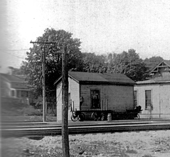
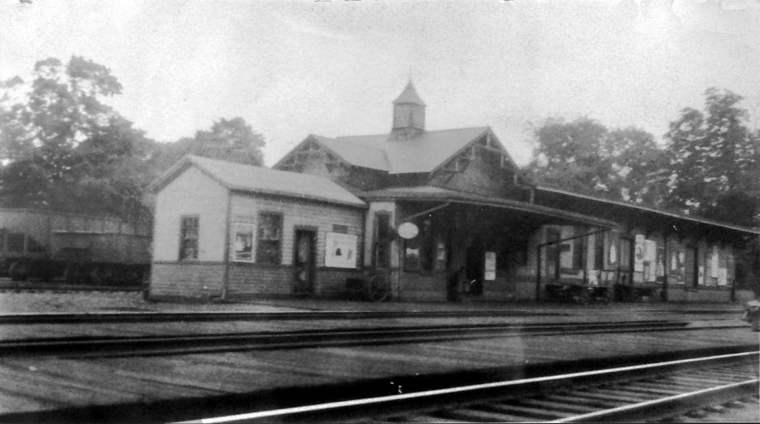
HAWLEYVILLE2 [SRR, 1872]
We think the small gabled structure at [1] is the 1872 Shepaug depot. The SRR opened for through service on 7/1/1872, including a six-mile link between here and Bethel that was built jointly with the D&N and operated by the latter company. Newspapers closest to home are the most reliable for local events and a key article from the Newtown Bee was reported on 7/6/1881 in the Danbury News. It says: "The old Shepaug building has been moved upon its new pins, where it will be freshened up for a baggage and freight room. The foundations for the new part, which will be the depot proper and contain the waiting rooms, are already well along, and we shall have our depot, apparently, in time for the opening of the line, which is still an uncertain date though near at hand." The image at [1] is from a larger photo which shows baggage carts in front of HAWLEYVILLE2. The shot at [2] shows the full union station, HAWLEYVILLE3, at a later date. The 1931 photo at [3] shows the rear of the building where the D&N met the SRR and intersected with the HRR as well. This building, later the telegraph office, would stand until at least 1947 with the rest of the union station. [REFS: CC/01/13/1872/04; WH/06/07/1872/02; SR/08/18/1880/05; NBE/11/17/1880/03: tin roof contract given; DN/12/01/1880/04; NHER/03/14/1881/04; DN/07/06/1881/00; HDC/07/23/1881/02; DN/07/27/1881/01; P35,39][rev022015]
We think the small gabled structure at [1] is the 1872 Shepaug depot. The SRR opened for through service on 7/1/1872, including a six-mile link between here and Bethel that was built jointly with the D&N and operated by the latter company. Newspapers closest to home are the most reliable for local events and a key article from the Newtown Bee was reported on 7/6/1881 in the Danbury News. It says: "The old Shepaug building has been moved upon its new pins, where it will be freshened up for a baggage and freight room. The foundations for the new part, which will be the depot proper and contain the waiting rooms, are already well along, and we shall have our depot, apparently, in time for the opening of the line, which is still an uncertain date though near at hand." The image at [1] is from a larger photo which shows baggage carts in front of HAWLEYVILLE2. The shot at [2] shows the full union station, HAWLEYVILLE3, at a later date. The 1931 photo at [3] shows the rear of the building where the D&N met the SRR and intersected with the HRR as well. This building, later the telegraph office, would stand until at least 1947 with the rest of the union station. [REFS: CC/01/13/1872/04; WH/06/07/1872/02; SR/08/18/1880/05; NBE/11/17/1880/03: tin roof contract given; DN/12/01/1880/04; NHER/03/14/1881/04; DN/07/06/1881/00; HDC/07/23/1881/02; DN/07/27/1881/01; P35,39][rev022015]

|

|
|
|
Max Miller Collection
|
|
 J.W. Swanberg Collection
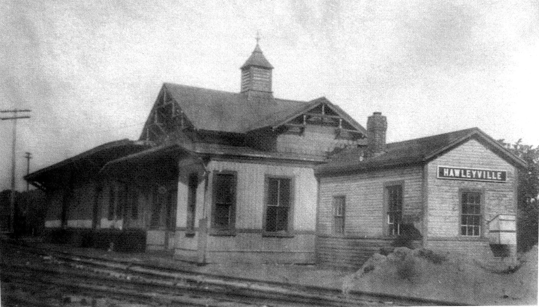
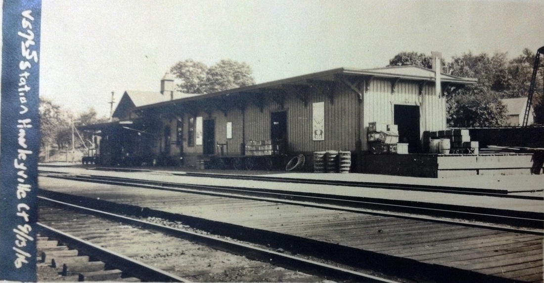
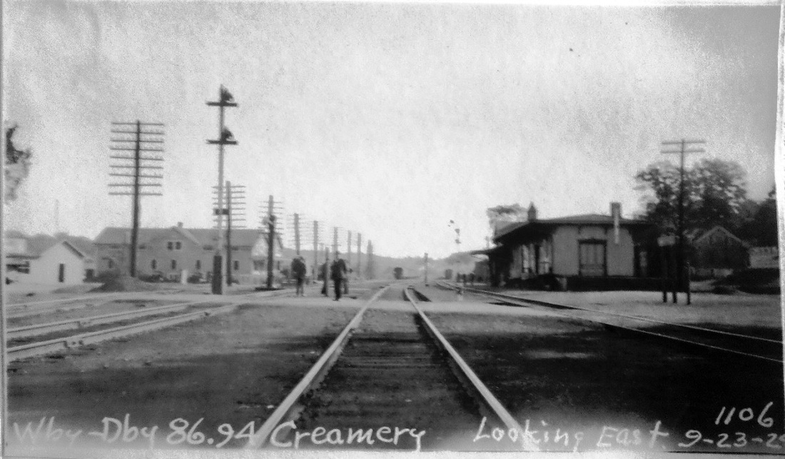
HAWLEYVILLE3 [NY&NE/HRR/D&N/SRR, 1881]
The unique view of this station at [1] is the only one we have seen, momentarily at least, without the freight house attached on the western end. Since NY&NE rail is already in front of it, the scene likely dates to between late 1880, when track layers were only three miles west of Hawleyville, and 7/25/1881 when the first NY&NE train ran. The Register reported in March, 1881 that locals were delighted that their village was now the junction of the HRR, SRR/D&N and the NY&NE. It goes on to say that "a union depot is to be built on the triangle to accommodate each road. The Courant's report of the 7/22/1881 railroad commissioners' inspection says that "the Shepaug's depot has been taken and doubled in size to accommodate its business and that of the New York & New England..." The Danbury News on 7/23/1881 said that the depot here "is formed with the Shepaug building with a new addition in course of completion. It stands between three roads roads centering there, and will furnish accommodation to all." The Journal Courier reported on 9/20/1881 that "the union depot at Hawleyville has been completed and is now used by all passenger trains on the New York & New England, Shepaug and Housatonic roads. Twenty-two regular trains now pass through Hawleyville daily." The NY&NE paid $4507.20 for the new depot, according to various R&LHS documents at the Baker Library. The cost was apportioned as 1/3 NY&NE, 1/3 HRR, 1/6 SRR and 1/6 D&N; the HRR paid $1502.40 on 3/10/1882 for its share. Great excitement accompanied the NY&NE's 1881 success in doing what its BH&E predecessor had been trying to accomplish since 1868. The Register said that "Property has risen higher than mining stocks and some cannot be bought for love or money." The Courant had already quipped in 1879 that "the New England railroad... will build the link from Waterbury to Fishkill at once and make a trunk line from Liverpool to China!... Hawleyville is to be a transfer point of some kind..." Good-natured municipal ribbing perhaps but, for its size, this village would see up to 150 daily trains at its height ca. 1900. By 1932, all passenger service had ended and the railroad, rather abruptly, closed this station. A Bee editorial remonstrated and asked Pres. John F. Pelley how he was going to draw his $100,000 per year salary by closing junctions and branches, the railroad's arms, legs, fingers and toes! You will rue the day! A better way to counter bus competition (the railroad had already begun to fight with NETCO) would be "to create a new department which should strive to get back some of the freight and passenger business you have lost." A cogent and cold social commentary from communities who faced the loss, likely unavoidable, of the economic benefit the railroad had brought.
IMAGES: [1] shot late 1880 to 7/25/1881; [2] southwest view with coach on Bethel line behind the station; [3] 1915 val map, track layout: arrows point to H2 (green), now the telegraph office, H3 (red), H1 site (blue), the creamery (yellow) where dairy products from all of Litchfield County were processed. Note orientation of map is north at bottom. [4] 9/13/1916 val photo, southeast view of the freight end of the depot; [5] 9/23/1924 PUC inspection photo; [6] 1934 aerial photo, entire station still standing; [7] NYNH&H #372 leads a freight up the Shepaug line on 8/2/1947, only the passenger portion of the depot remains. Demise date of freight portion: 1940-1947, passenger portion: 1947 to 1954, based on other J. W. Swanberg photos.
REFERENCES: CC/11/07/1868/01; HDC/11/20/1868/04; HDC/01/03/1870/04; HDC/04/12/1879/04; HDC/08/17/1880/02; SR/08/18/1880/05; DN/12/01/1880/04; NHJC/03/04/1881/03; NHER/03/14/1881/04; NHER/04/14/1881/04; HDC/07/23/1881/02; DN/07/27/1881/01; CWN/08/30/1882/02; NHJC/09/20/1881/02; NBE/11/03/1911/01; NBE/01/08/1932/01: some train service discontinued; NBE/09/02/1932/01; D57,141,159; B834,846; NL6.4.8; SL11.1.22; SL12.1.25.
TCS REVISIONS: 2/19/2018, 6/20/2022.
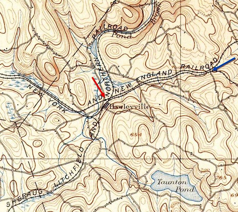
|

|
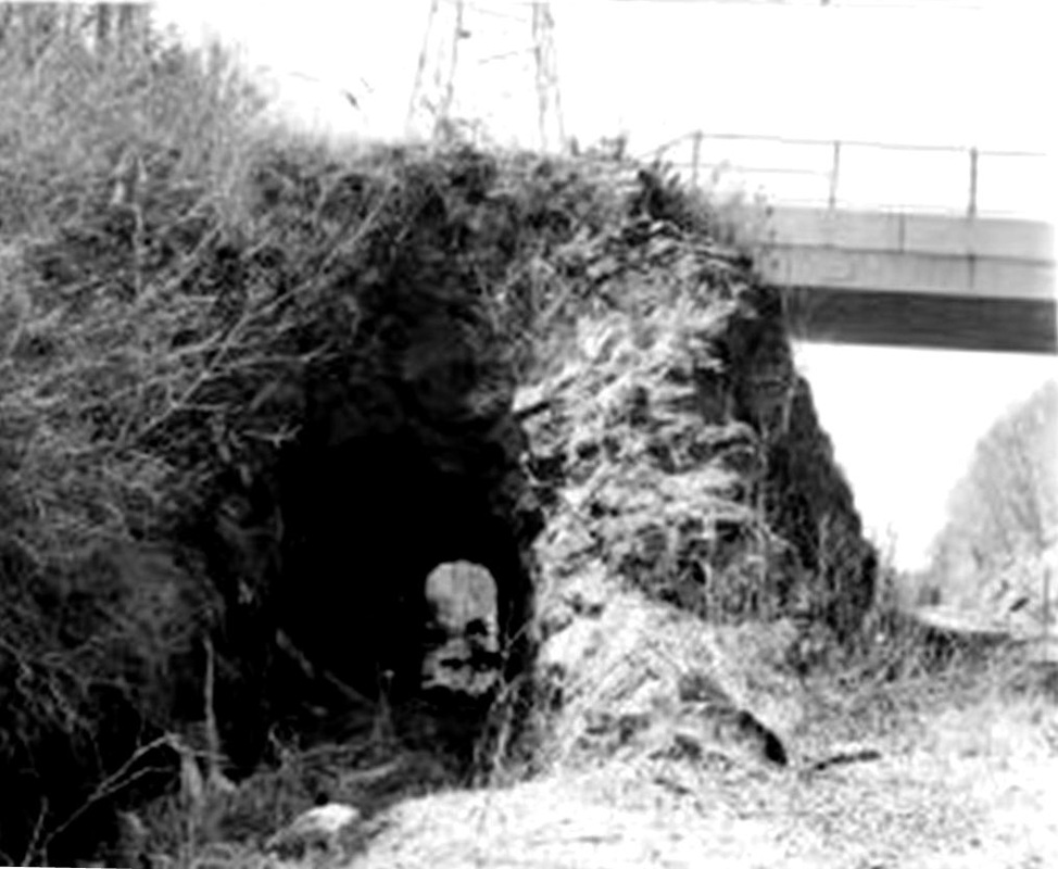
|
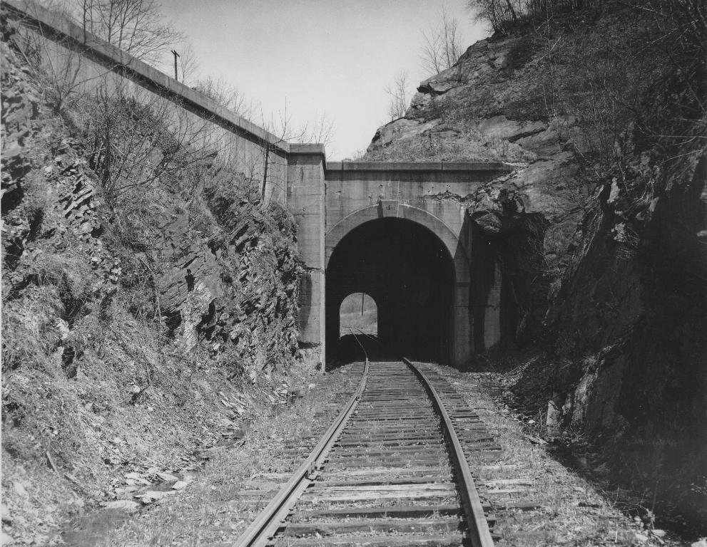
Copyright, NHRHTA
|
 T.J. Donahue photo, John Garafalo Coll.
The history of this railroad village is enhanced by the two tunnels that were built to reach it. The first was the 200-ft HRR bore, an impressive engineering feat in 1839 that received scant mention in the newspapers of the day. This first tunnel was joined by another when the BH&E drilled through the mountain in 1870, as reported in the Courant which said the new tunnel was cut wide enough for a double track, was twice the length of the HRR's and 27 feet lower than the old one. Unused for a decade, it was in the news in 1880 again as the NY&NE was completing the BH&E's dream of reaching the Hudson River, the Courant then reporting the dimensions to be 380 feet in length, 26 feet in width and 20 feet in height. The 1892 topo map at [1] shows the 1881 NY&NE line paralleling the 1840 HRR (unlabeled). Contrary to claims elsewhere, there was no shared track from Hawleyville at our red arrow to the tunnels at our blue arrow -- these were two, independent, competing lines. The ca. 1908 shot at [2] shows a Bridgeport-bound train emerging from the east portal of the HRR tunnel; the NY&NE's is out of sight in the ravine to the right with its telegraph line surmounting the rocks. The photo at [3] essentially duplicates the view at [3], but looking west through the HRR tunnel. The old tunnel was abandoned in 1911 upon the completion of the new, double-tracked Maybrook line which replaced the old ROWs. The NY&NE tunnel would be reinforced with concrete by the NYNH&H as part of the reconfiguration, as seen at [4], and it was in service until 1948 when the Hawleyville-Southbury portion of the NY&NE was abandoned. The 1963 image at [5] shows the Parmalee Hill Rd. and bridge effectively made into a triple crossing over the HRR tunnel barely seen at far right, the NY&NE tunnel far below, and the new Maybrook line which for which rock was cut away completely above the tunnels. The Maybrook line has been cut back to Track 2 in the 1950s and only ties remaining for Track 1. Both bores will be extant til the end of time. [REFS: SL32.1.36][rev071822]

HAYDENS1 [H&NH, 1844; depot, c1855?]
The 1855HC map indicates that this stop in the town of WINDSOR was at least here by that date; it probably does not go back to the opening of the Hartford-Springfield line in 1844. What shelter or platform first served here is not known but the the stop is mentioned in periodicals back to 1858. It does not appear on timetables or lists that we have seen before 1880. The eponymous Hayden surname derives from William Hayden who came to Windsor with the second wave of English colonists in 1639 and whose descendants populated the area around the station which was named for the family. [REFS: GED1858; BA23.1870.00 (4/2/1869); NYT/04/09/1871/01; HDC/04/10/1871/02; NA/07/09/1873/03; CRC22.1875.35; PTH380. 1871.17][rev072816]
The 1855HC map indicates that this stop in the town of WINDSOR was at least here by that date; it probably does not go back to the opening of the Hartford-Springfield line in 1844. What shelter or platform first served here is not known but the the stop is mentioned in periodicals back to 1858. It does not appear on timetables or lists that we have seen before 1880. The eponymous Hayden surname derives from William Hayden who came to Windsor with the second wave of English colonists in 1639 and whose descendants populated the area around the station which was named for the family. [REFS: GED1858; BA23.1870.00 (4/2/1869); NYT/04/09/1871/01; HDC/04/10/1871/02; NA/07/09/1873/03; CRC22.1875.35; PTH380. 1871.17][rev072816]
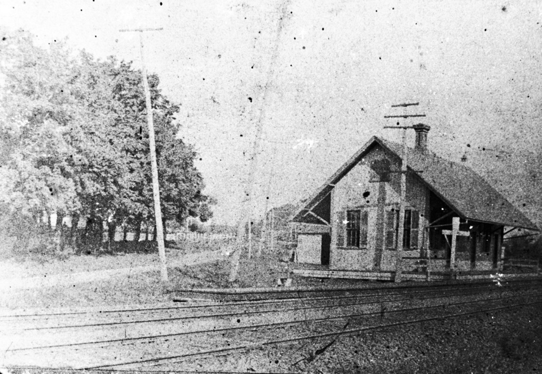
Julius Ruscavage Collection,
Windsor Historical Society
|

|

|
HAYDENS2 [NYNH&H, 1874]
Articles in the 1874 Courant said in March that "it is proposed to establish a railway station at Hayden's crossing," though it is a line in an article about the HRR, but in November the officers of the NYNH&H were making "the necessary surveys and plans for the building." The railroad commissioners corroborate in their annual report of May, 1875 that the NYNH&H had built a new depot at this location. HAYDENS is on an 1880 list of stations and the first timeteable we have that lists it is 1894. A visit to the Windsor Historical Society [click here] proved fruitful recently with the able help of Archivist Michelle Tom who produced the photo of HAYDENS2 seen at [1]. The location on the 1869 Baker & Tilden map at [2] is incorrect as proved by the photo which shows the depot on the north side of Hayden Station Rd. Note the half dozen Hayden residences in the immediate area. The 1893 topo map at [3] does not distinguish the side of the track on which the station stood but does put it north of the fork. HAYDENS2 burned on 1/20/1904. The fire was discovered by a resident from across the street and Station Agent Walter Foye was notified. The building was reportedly so full of smoke that it was impossible to save any contents. The lack of available water supply doomed the building thought to have been set afire by a passing locomotive. [REFS: HDC/03/02/1874/04; HDC/11/14/1874/02 verify; HDC/11/17/1874/02; CR/11/21/1874/03; CRC22.1875.35 recheck; CRC23.1876.253; 1883TT: no; 1894TT: yes; HC/01/21/1904/09][rev072816]
Articles in the 1874 Courant said in March that "it is proposed to establish a railway station at Hayden's crossing," though it is a line in an article about the HRR, but in November the officers of the NYNH&H were making "the necessary surveys and plans for the building." The railroad commissioners corroborate in their annual report of May, 1875 that the NYNH&H had built a new depot at this location. HAYDENS is on an 1880 list of stations and the first timeteable we have that lists it is 1894. A visit to the Windsor Historical Society [click here] proved fruitful recently with the able help of Archivist Michelle Tom who produced the photo of HAYDENS2 seen at [1]. The location on the 1869 Baker & Tilden map at [2] is incorrect as proved by the photo which shows the depot on the north side of Hayden Station Rd. Note the half dozen Hayden residences in the immediate area. The 1893 topo map at [3] does not distinguish the side of the track on which the station stood but does put it north of the fork. HAYDENS2 burned on 1/20/1904. The fire was discovered by a resident from across the street and Station Agent Walter Foye was notified. The building was reportedly so full of smoke that it was impossible to save any contents. The lack of available water supply doomed the building thought to have been set afire by a passing locomotive. [REFS: HDC/03/02/1874/04; HDC/11/14/1874/02 verify; HDC/11/17/1874/02; CR/11/21/1874/03; CRC22.1875.35 recheck; CRC23.1876.253; 1883TT: no; 1894TT: yes; HC/01/21/1904/09][rev072816]
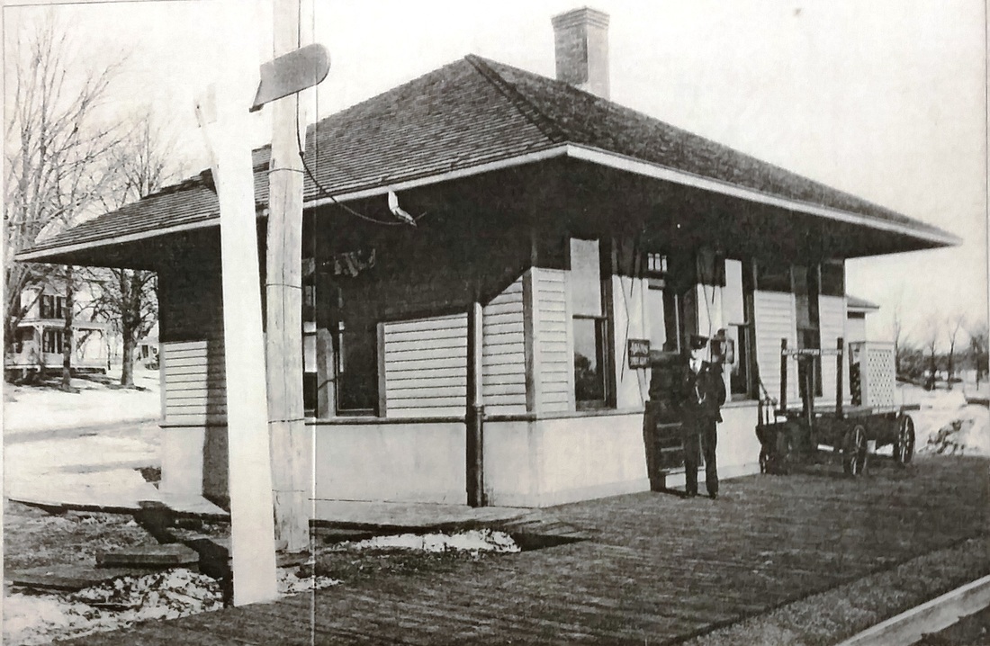
|
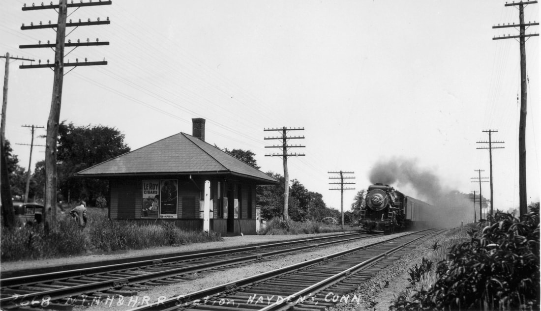
Richard A. Fleischer Collection
|

Max Miller Collection
|
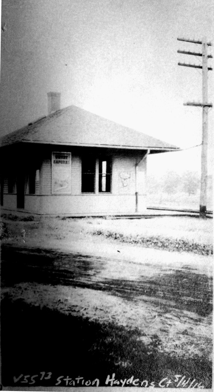
HAYDENS3 [NYNH&H, 1904]
This third depot was built to replace the one that burned in 1904; no actual notice has been found for its completion. The photo at [1] probably dates to the 1920s. The paddle is down to signal the train, presumably for a waiting passenger. A smartly uniformed station agent appears to be on duty at what was mostly only a flag stop. The shot at [2] is a Lewis H. Benton, ca. June, 1930, with a southbound train bearing down on the station; Irving Drake and his sedan are hiding in the bushes in the right foreground. The northward-looking PUC photo at [3] is dated 9/26/1924. The ICC val photo at [4] dates to 8/4/1916. [REFS: CRC52.1904.21][rev072816]
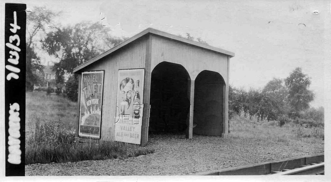
HAYDENS4 [NYNH&H, 1934?]
Just received this photo of last station here, thanks to George (Skip) Ford. This PUC shot is dated 7/13/1934, which is when this structure may have been put up and the old one taken down due to dwindling patronage and probable attempts by the near-bankrupt NYNH&H to save taxes by reducing the footprint of its structures or razing them completely. It is similar to ones seen elsewhere on the system, notably on the Shore Line. By our rev12/10/1950TT, only one morning down-train and one evening up-train were stopping here. In 1950 the NYNH&H asked the PUC for permission to abandon "seven little-used stations" in various parts of the state, this being one of them. Somewhere before the 9/28/1952TT, this stop was eliminated. Arizona senator Carl Hayden, scion of the local family, remarked at the time that it was "a damned shame" when the railroad closed this stop. A boulder and a tablet reportedly commemorate the family, its namesake locale and the nearby train station that once served it. [REFS: HC/12/29/1950/04; HC/12/29/1968/3B][add032619]
Just received this photo of last station here, thanks to George (Skip) Ford. This PUC shot is dated 7/13/1934, which is when this structure may have been put up and the old one taken down due to dwindling patronage and probable attempts by the near-bankrupt NYNH&H to save taxes by reducing the footprint of its structures or razing them completely. It is similar to ones seen elsewhere on the system, notably on the Shore Line. By our rev12/10/1950TT, only one morning down-train and one evening up-train were stopping here. In 1950 the NYNH&H asked the PUC for permission to abandon "seven little-used stations" in various parts of the state, this being one of them. Somewhere before the 9/28/1952TT, this stop was eliminated. Arizona senator Carl Hayden, scion of the local family, remarked at the time that it was "a damned shame" when the railroad closed this stop. A boulder and a tablet reportedly commemorate the family, its namesake locale and the nearby train station that once served it. [REFS: HC/12/29/1950/04; HC/12/29/1968/3B][add032619]
HAYSTACK [> WEST NORFOLK]
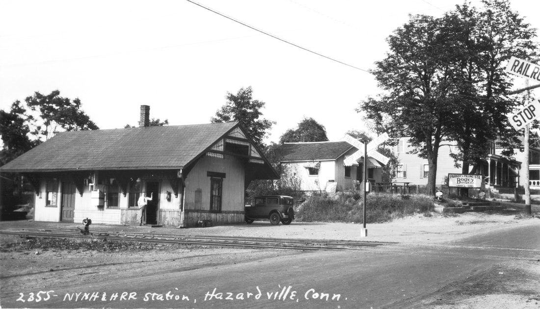
Richard A. Fleischer Collection
|

|
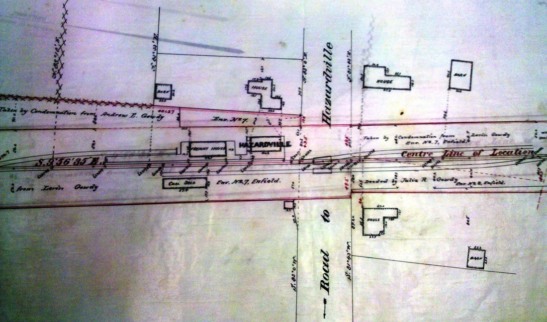
|
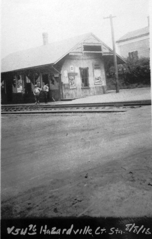
HAZARDVILLE [CC, 1876]
This station was established by the Connecticut Central RR in the eastern section of ENFIELD and was also known as SCITICO for the village in which it was actually located. Image [1] is Lewis H. Benton's photo #2355 shot in June, 1919 with Irving Drake at the depot door and his sedan parked in the rear. Interestingly, it is the surname of Augustus Hazard for which the village is named, not the hazardous gunpowder he produced here. The massive operation, though it languished after the Civil War, probably required the construction of a separate freight depot in contrast to the combination stations built elsewhere on the line. That structure is seen behind the passenger station in view [2], which was taken on a 10/12/1933 PUC inspection trip. Image [3] is an 1888 NY&NE real estate map and [4] is an 8/8/1916 val photo. According to the SSRR addenda (3/27/1939, 6/15/1939) an offer of $40 was made and it was removed on 5/25/1939. [REFS: HWT/08/14/1875/02; HDC/09/08/1875/04; HDC/01/07/1876/02; HDC/01/08/ 1876/02; CRC23.1876 .48; HC/11/12/1968/26C][rev010318]
This station was established by the Connecticut Central RR in the eastern section of ENFIELD and was also known as SCITICO for the village in which it was actually located. Image [1] is Lewis H. Benton's photo #2355 shot in June, 1919 with Irving Drake at the depot door and his sedan parked in the rear. Interestingly, it is the surname of Augustus Hazard for which the village is named, not the hazardous gunpowder he produced here. The massive operation, though it languished after the Civil War, probably required the construction of a separate freight depot in contrast to the combination stations built elsewhere on the line. That structure is seen behind the passenger station in view [2], which was taken on a 10/12/1933 PUC inspection trip. Image [3] is an 1888 NY&NE real estate map and [4] is an 8/8/1916 val photo. According to the SSRR addenda (3/27/1939, 6/15/1939) an offer of $40 was made and it was removed on 5/25/1939. [REFS: HWT/08/14/1875/02; HDC/09/08/1875/04; HDC/01/07/1876/02; HDC/01/08/ 1876/02; CRC23.1876 .48; HC/11/12/1968/26C][rev010318]