Track 12: CT Passenger Stations, CL-CR
See TCS Home Page links for notes, abbreviations, and sources.
Use Track 11 map link to locate stations, rail and trolley lines, and POIs.
See TCS Home Page links for notes, abbreviations, and sources.
Use Track 11 map link to locate stations, rail and trolley lines, and POIs.
|
|
|
CLARKS CORNER1 [BH&E, 1872; opens as GOSHEN]
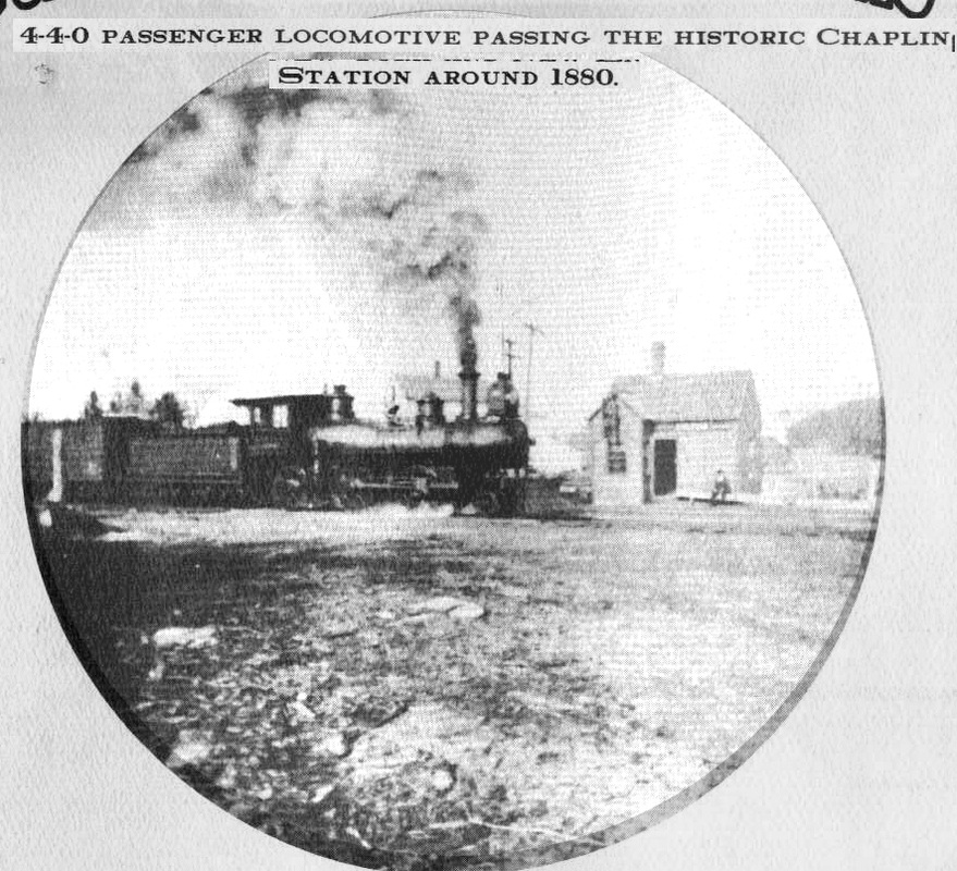
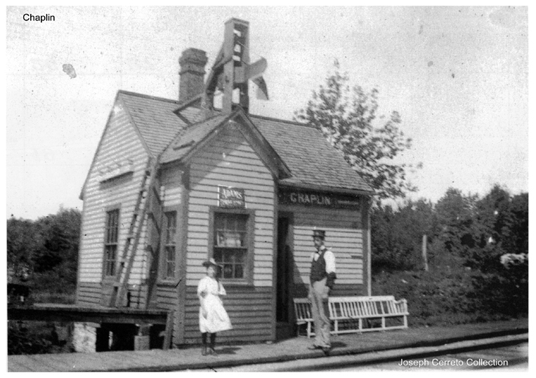
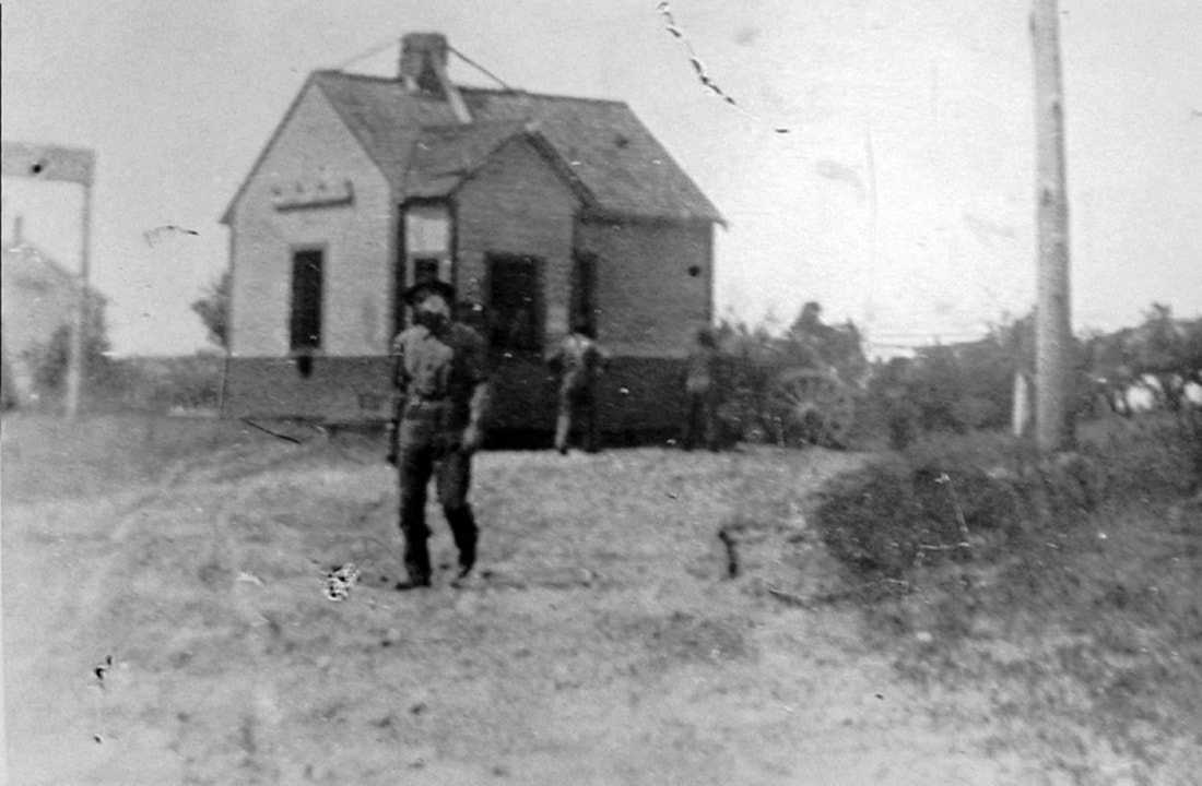
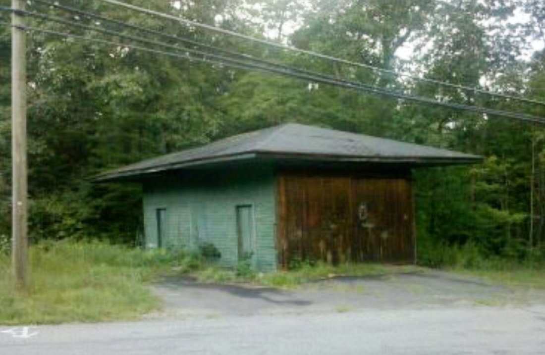
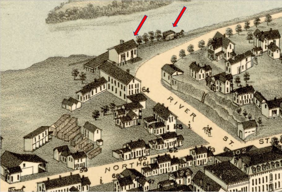
This stop in the town of Hampton, about eight miles east of Willimantic, was on the Chaplin border and hence alternately known as such in [1]. The 1895 photo at [2] shows Stationmaster Elmer Claslin Jewett who would later purchase this station and move it [3] to his property when CLARKS CORNER2 was built in 1901. The shot at [4] shows the depot to the left of Jewett's home. The attractive little structure was moved in 1991 to the Connecticut Eastern Railroad Museum [click here]. The signboard says CHAPLIN. Any attempt to follow an evolution in the names here is in our opinion an exercise in frustration without precedent! [REFS: HC/09/01/1957/6A; K:110; R41][rev020918]
This stop in the town of Hampton, about eight miles east of Willimantic, was on the Chaplin border and hence alternately known as such in [1]. The 1895 photo at [2] shows Stationmaster Elmer Claslin Jewett who would later purchase this station and move it [3] to his property when CLARKS CORNER2 was built in 1901. The shot at [4] shows the depot to the left of Jewett's home. The attractive little structure was moved in 1991 to the Connecticut Eastern Railroad Museum [click here]. The signboard says CHAPLIN. Any attempt to follow an evolution in the names here is in our opinion an exercise in frustration without precedent! [REFS: HC/09/01/1957/6A; K:110; R41][rev020918]

|
|
|
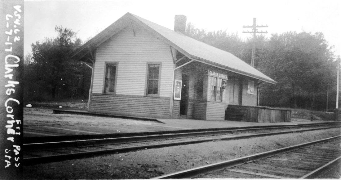
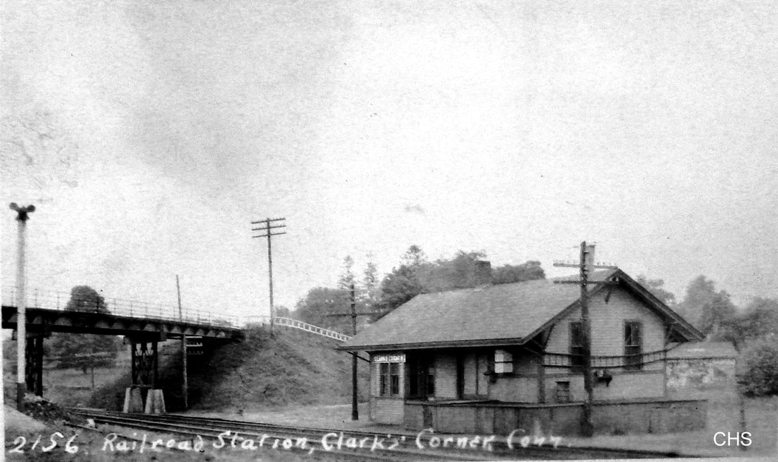
CLARKS CORNER2 [NYNH&H, 1901]
The 6/19/1901 image at [1] shows both the old and the new station, the latter it claims built in May, 1901 and the old one yet to be moved. Stationmaster Jewett stands to the right. The val photo at [2] is dated 6/7/1917. The Lewis H. Benton shot #2156 at [3] was taken in 1928, late June or early July. The NYNH&H continued to call this stop CLARKS CORNER, the village name which alternated with the others, until it drops off timetables between 1937 and 1939. [REFS: CRC47.1899.30; CRC48.1900.21][rev020918]
The 6/19/1901 image at [1] shows both the old and the new station, the latter it claims built in May, 1901 and the old one yet to be moved. Stationmaster Jewett stands to the right. The val photo at [2] is dated 6/7/1917. The Lewis H. Benton shot #2156 at [3] was taken in 1928, late June or early July. The NYNH&H continued to call this stop CLARKS CORNER, the village name which alternated with the others, until it drops off timetables between 1937 and 1939. [REFS: CRC47.1899.30; CRC48.1900.21][rev020918]
CLARKVILLE [> GRIFFINS]

CLARKSVILLE [NYP&B, c1840?]
This stop in the town of STONINGTON was reportedly established early on by the NYP&B which opened in 1837. We finally found the station on this 1893 map a half century later but have never seen it on any timetable. While it is often the case that depots that we know of do not show up on maps, this is an example of the reverse. We need to check further. [NHER/05/19/1900/01: wreck here one mile south of Westerly]
This stop in the town of STONINGTON was reportedly established early on by the NYP&B which opened in 1837. We finally found the station on this 1893 map a half century later but have never seen it on any timetable. While it is often the case that depots that we know of do not show up on maps, this is an example of the reverse. We need to check further. [NHER/05/19/1900/01: wreck here one mile south of Westerly]
|
|

|

CLAYTONS [HP&F, c1872]
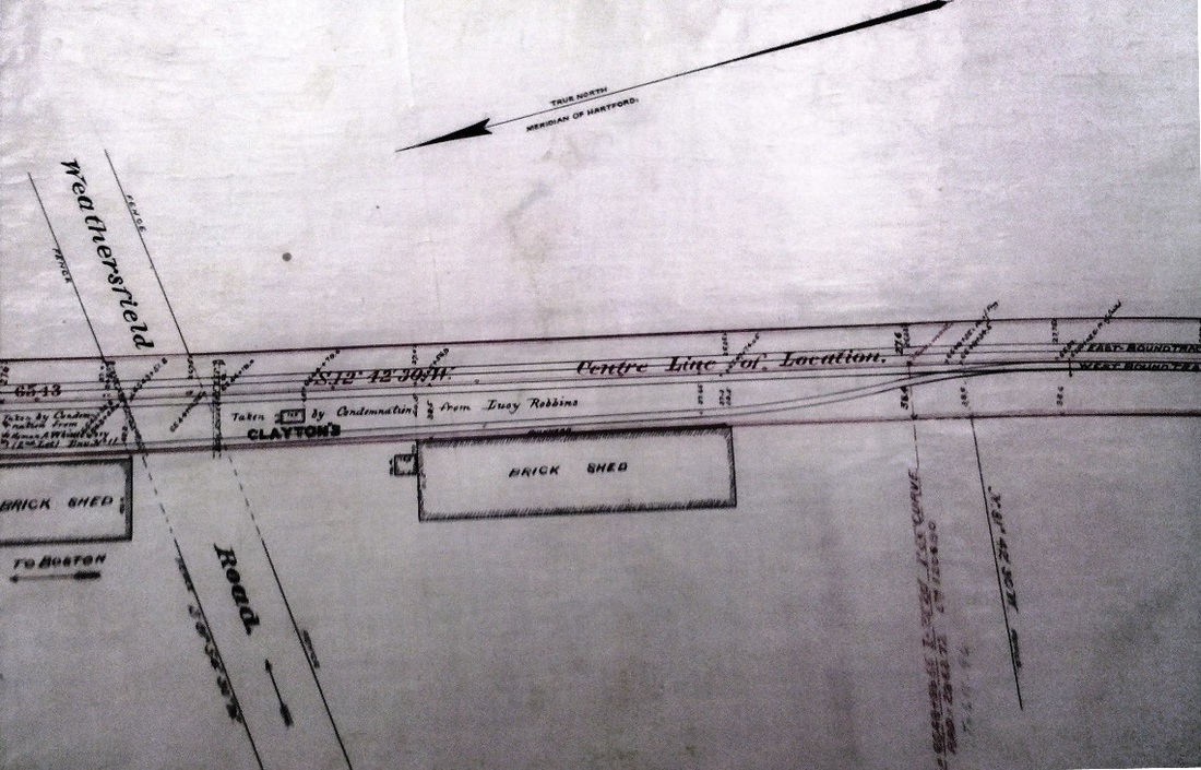
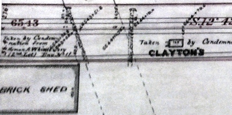
According to timetables, this Newington flag stop made its debut around 1872. The images at [1] and [2] are from an 1886 NY&NE property map revised to 1889. The map shows what appears to be an 8x16-ft structure standing in the southwest quadrant of the Wethersfield Rd. crossing, today's Rte. 175. The adjacent brickyards made this a freight as well as a passenger stop and the siding here was long enough for some train meets. Understandably, this heavily trafficked grade crossing was the site of numerous accidents, both with steam trains and third-rail electric cars while they were in use from Hartford to Bristol. The brickyard sheds were said to have made visibility bad for both the trains and the public. The 1893 map at [3] shows the proximity to the junction at NEWINGTON, but puts the tick mark, incorrectly, north of the grade crossing. Interestingly, this otherwise obscure point was where the Hartford & Harlem line was to intersect with the NY&NE. That incarnation of the parallel scheme to challenge the Consolidated was never built but the railroad commissioners collection [RG 041] at CSL has numerous, detailed maps of the projected right of way from Greenwich to New Haven and northward from there. The shot at [4] is the 1915 val map showing the siding and the sheds, then owned by the Murray Bros., but there is no station structure here by that time. [REFS: PTH107.1858.10: no; PTH380.1871.10: no; HPF ETT 9/18/1872: yes; HDC/11/20/1882/02; HDC/03/02/1883/02; HDC/07/03/1883/02; NHER/07/09/1883/02; NHER/01/19/1891/04; HC/08/08/1898/03; HC/09/20/1898/03; HC/08/07/1900/03; HC/02/06/1990/??; SL28.1.9 NYNE1889; RAM08][rev011918]
According to timetables, this Newington flag stop made its debut around 1872. The images at [1] and [2] are from an 1886 NY&NE property map revised to 1889. The map shows what appears to be an 8x16-ft structure standing in the southwest quadrant of the Wethersfield Rd. crossing, today's Rte. 175. The adjacent brickyards made this a freight as well as a passenger stop and the siding here was long enough for some train meets. Understandably, this heavily trafficked grade crossing was the site of numerous accidents, both with steam trains and third-rail electric cars while they were in use from Hartford to Bristol. The brickyard sheds were said to have made visibility bad for both the trains and the public. The 1893 map at [3] shows the proximity to the junction at NEWINGTON, but puts the tick mark, incorrectly, north of the grade crossing. Interestingly, this otherwise obscure point was where the Hartford & Harlem line was to intersect with the NY&NE. That incarnation of the parallel scheme to challenge the Consolidated was never built but the railroad commissioners collection [RG 041] at CSL has numerous, detailed maps of the projected right of way from Greenwich to New Haven and northward from there. The shot at [4] is the 1915 val map showing the siding and the sheds, then owned by the Murray Bros., but there is no station structure here by that time. [REFS: PTH107.1858.10: no; PTH380.1871.10: no; HPF ETT 9/18/1872: yes; HDC/11/20/1882/02; HDC/03/02/1883/02; HDC/07/03/1883/02; NHER/07/09/1883/02; NHER/01/19/1891/04; HC/08/08/1898/03; HC/09/20/1898/03; HC/08/07/1900/03; HC/02/06/1990/??; SL28.1.9 NYNE1889; RAM08][rev011918]
|
|
|

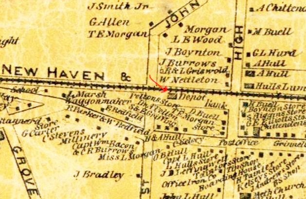
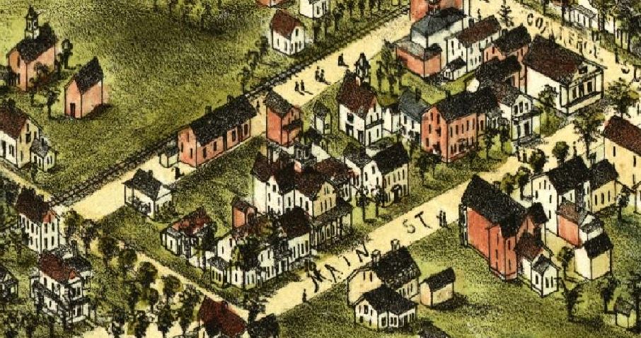
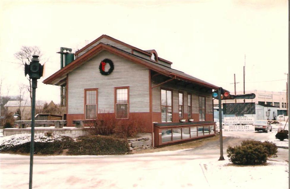
CLINTON1 [NH&NL, 1852]
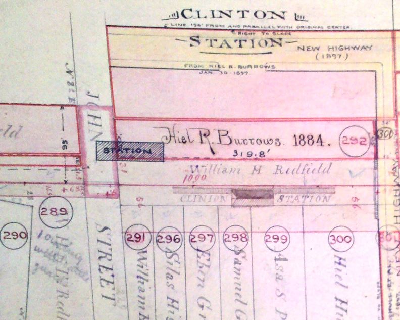
The snippet at [1] is from the 1859MC map and shows this station south of the tracks and just east of John St. The image at [2] from the 1881 O.H. Bailey bird's-eye map of Clinton shows the physical appearance of the depot, which was used for both passengers and freight. On 11/7/1897, with CLINTON2 about to open, this combination station was moved about 700 feet west for use solely as a freight house, which usage lasted until the 1950s. It still stands today in 2015 on part of the 1852 original ROW left in place when the Shore Line was double-tracked and straightened here in 1891. The photo at [3] was taken in the 1980s and we snapped the shot at [4] on 2/15/2012. The 160-year-old stucture was still looking pretty spiffy at that time! [REFS: R41][rev011918]
The snippet at [1] is from the 1859MC map and shows this station south of the tracks and just east of John St. The image at [2] from the 1881 O.H. Bailey bird's-eye map of Clinton shows the physical appearance of the depot, which was used for both passengers and freight. On 11/7/1897, with CLINTON2 about to open, this combination station was moved about 700 feet west for use solely as a freight house, which usage lasted until the 1950s. It still stands today in 2015 on part of the 1852 original ROW left in place when the Shore Line was double-tracked and straightened here in 1891. The photo at [3] was taken in the 1980s and we snapped the shot at [4] on 2/15/2012. The 160-year-old stucture was still looking pretty spiffy at that time! [REFS: R41][rev011918]
|
New Haven Museum
|
|
|
|
Richard A. Fleischer Collection
|
 NHRHTA, Inc.
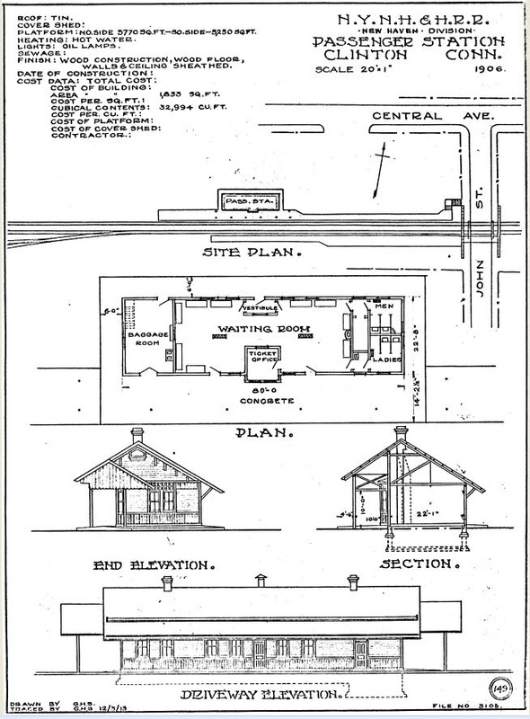
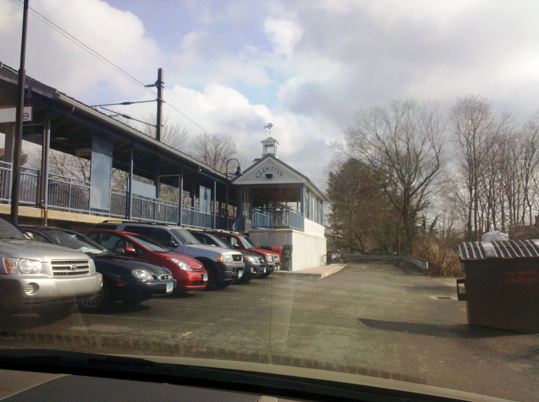
CLINTON2 [NYNH&H, 1897]
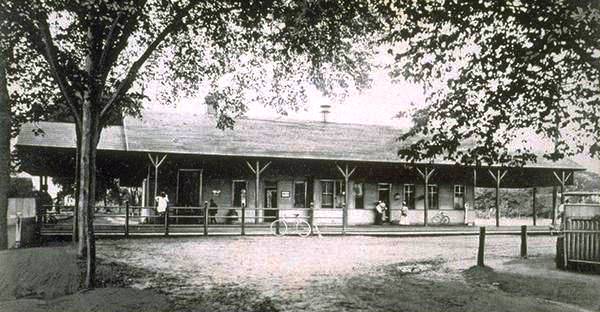
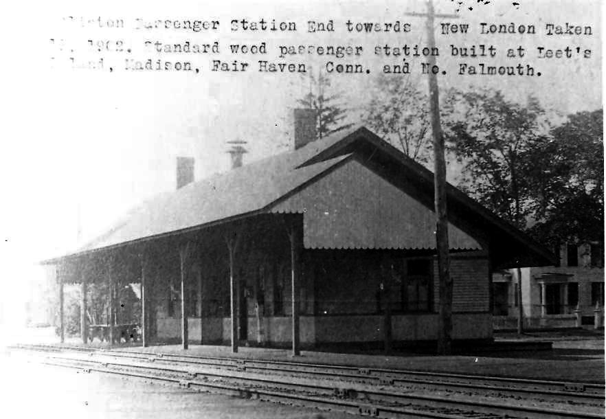
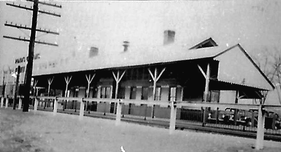
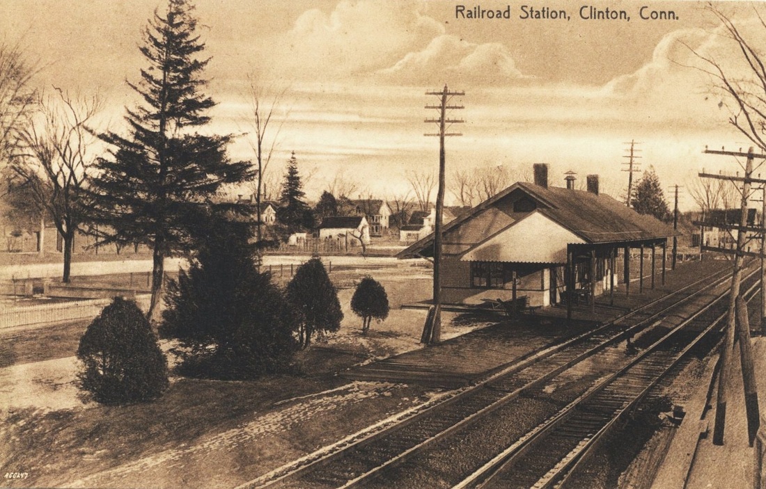
This 23x80-ft station opened on 11/19/1897 on the north side of the tracks and was to be painted in "a cream or buff color, with dark trimmings and red sash." The tracks were raised for nearly a mile to eliminate four grade crossings as part of the improvement project with a new station which was said to be "the model depot of the division outside of Branford [see the beautiful, turreted BRANFORD3] between New Haven and New London." The 1914 postcard at [1] shows the completed work, with the High (today Hull) St. 'tunnel' in the right foreground, the stairway up to the eastbound track, and the park-like grounds in which the station sat. The 1892 real estate atlas at [2] shows the location of both the old and new stations, the latter astride the old grade crossing at John St. which was dead-ended at that time. The view at [3] looks south and shows the rear of the depot. The item at [4] is dated 1902 and contains the valid comment that this station was of a pattern used at some nearby locations. The saltbox style was indeed utilized by the NYNH&H "as the new standard pattern of stations on the Shore Line" in this period. The photo at [5] shows the Pond's factory, Chesebrough-Pond's after 1955 and defunct as of 2012 after 124 years of operation in town, just west of the station. The card at [6] is a northeasterly view. The tracing sheet at [7] mislabels Hull St. as John St. This depot possibly came down as early as 1960 when C-P bought the railroad property to the east of its complex for parking, including "the old railroad station and freight handling building," according to a late 1959 Courant article. If the latter reference meant CLINTON1, it must have been sold off separately because our previous entry shows it still extant today. [REFS: NHER/08/12/1897/02; HWT/11/01/1897/01; HDC/11/22/1897/11; CRC45.1897.21; HC/10/09/1959/14; NLD/12/24/2012/00; R41][rev113015, 111518]
This 23x80-ft station opened on 11/19/1897 on the north side of the tracks and was to be painted in "a cream or buff color, with dark trimmings and red sash." The tracks were raised for nearly a mile to eliminate four grade crossings as part of the improvement project with a new station which was said to be "the model depot of the division outside of Branford [see the beautiful, turreted BRANFORD3] between New Haven and New London." The 1914 postcard at [1] shows the completed work, with the High (today Hull) St. 'tunnel' in the right foreground, the stairway up to the eastbound track, and the park-like grounds in which the station sat. The 1892 real estate atlas at [2] shows the location of both the old and new stations, the latter astride the old grade crossing at John St. which was dead-ended at that time. The view at [3] looks south and shows the rear of the depot. The item at [4] is dated 1902 and contains the valid comment that this station was of a pattern used at some nearby locations. The saltbox style was indeed utilized by the NYNH&H "as the new standard pattern of stations on the Shore Line" in this period. The photo at [5] shows the Pond's factory, Chesebrough-Pond's after 1955 and defunct as of 2012 after 124 years of operation in town, just west of the station. The card at [6] is a northeasterly view. The tracing sheet at [7] mislabels Hull St. as John St. This depot possibly came down as early as 1960 when C-P bought the railroad property to the east of its complex for parking, including "the old railroad station and freight handling building," according to a late 1959 Courant article. If the latter reference meant CLINTON1, it must have been sold off separately because our previous entry shows it still extant today. [REFS: NHER/08/12/1897/02; HWT/11/01/1897/01; HDC/11/22/1897/11; CRC45.1897.21; HC/10/09/1959/14; NLD/12/24/2012/00; R41][rev113015, 111518]
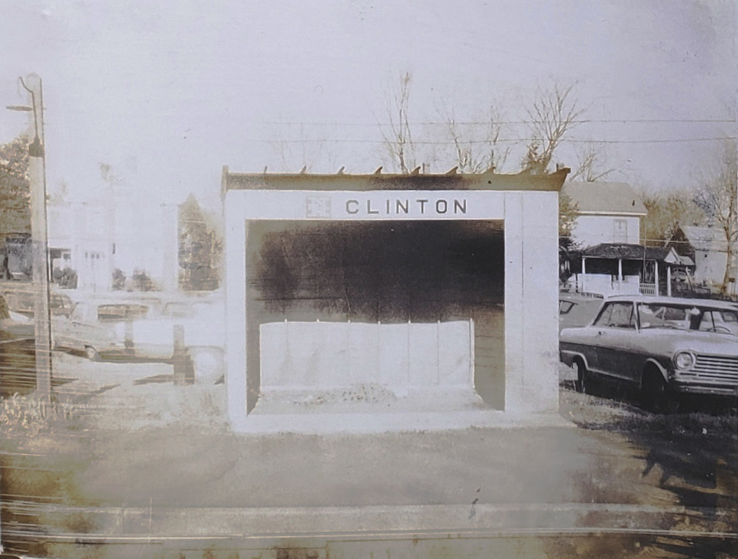
CLINTON3 [NYNH&H, 1960]
The 1959 article cited above also stated that, as part of the agreement, C-P would "provide a right-of-way from Central Avenue to the new passenger shelter on the southeast corner of the property..." [and] a protective fence around that portion of the property retained by the railroad." A Courant article in 1973 said that Penn Central intended "to sell or raze shelters and platforms at Stonington, East Lyme, Clinton, Madison and Branford. A recently obtained album has this photo of CLINTON3 in 1969 under Penn Central ownership, having been transferred from the NYNH&H. The album has been donated to UConn Archives & Special Collectiions. [REFS: HC/04/20/1958/9D; HC/06/27/1958/8D HC/10/09/1959/14A; HC/06/12/1960/6B3; HC/03/27/1973/13][rev111118, 080619, 122121]
The 1959 article cited above also stated that, as part of the agreement, C-P would "provide a right-of-way from Central Avenue to the new passenger shelter on the southeast corner of the property..." [and] a protective fence around that portion of the property retained by the railroad." A Courant article in 1973 said that Penn Central intended "to sell or raze shelters and platforms at Stonington, East Lyme, Clinton, Madison and Branford. A recently obtained album has this photo of CLINTON3 in 1969 under Penn Central ownership, having been transferred from the NYNH&H. The album has been donated to UConn Archives & Special Collectiions. [REFS: HC/04/20/1958/9D; HC/06/27/1958/8D HC/10/09/1959/14A; HC/06/12/1960/6B3; HC/03/27/1973/13][rev111118, 080619, 122121]
 Lee Carlson photo
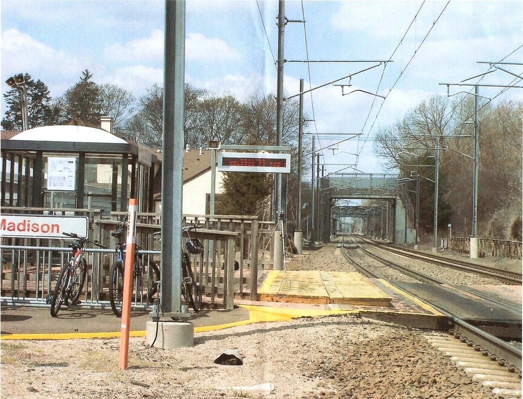
CLINTON4 [SLE, 1990]
These small plexiglass stations were erected for the start of Shore Line East service on 5/29/1990. We have copied MADISON3 here as an example of one of these structures. [REFS: NYT/05/27/1990/XX3][rev120215]
These small plexiglass stations were erected for the start of Shore Line East service on 5/29/1990. We have copied MADISON3 here as an example of one of these structures. [REFS: NYT/05/27/1990/XX3][rev120215]
|

|
Wikipedia
|
CLINTON5 [SLE, 2005]
According to Wikipedia, the new station here opened on 7/25/2005. The old Chesebrough-Pond's complex is seen in [3], recently reported to be in the works to become a recreation complex. [REFS: NHR/01/25/2015/00][rev120215]
According to Wikipedia, the new station here opened on 7/25/2005. The old Chesebrough-Pond's complex is seen in [3], recently reported to be in the works to become a recreation complex. [REFS: NHR/01/25/2015/00][rev120215]
CLINTONVILLE [> NORTHFORD]

CLUB HOUSE [NY&NE, c1880]
The switch shanty marked the start of single track from here in BOLTON eastward to STEELES. In later NYNH&H days, a nearby recreational cottage was used by railroad officials, hence the name of this location. The precise origins of this point are something we would like to find more about. This was not a regular passenger stop that we know of but we have yet to check all our timetables.
The switch shanty marked the start of single track from here in BOLTON eastward to STEELES. In later NYNH&H days, a nearby recreational cottage was used by railroad officials, hence the name of this location. The precise origins of this point are something we would like to find more about. This was not a regular passenger stop that we know of but we have yet to check all our timetables.
|
|
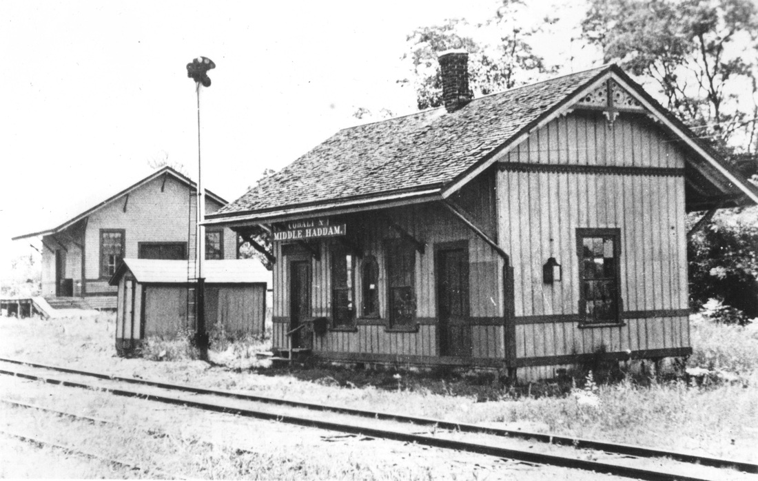
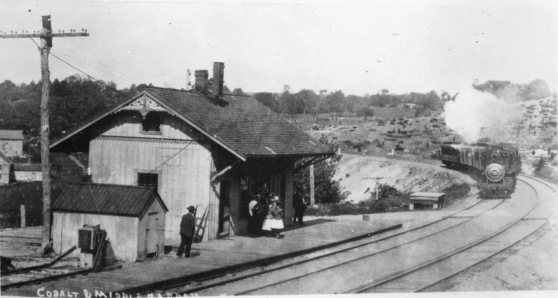
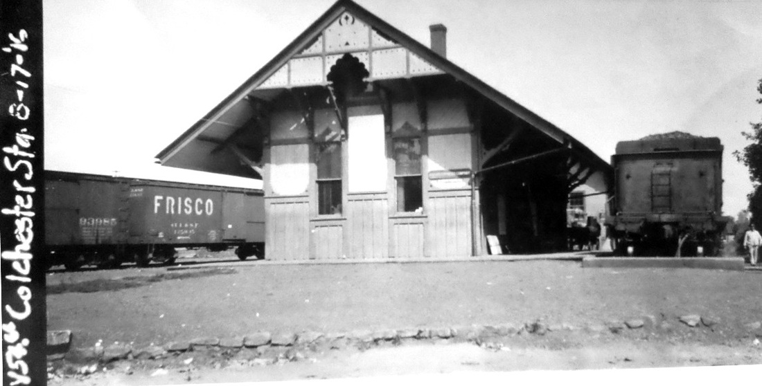
COBALT AND MIDDLE HADDAM [NHM&W, 1873]
This stop in the town of EAST HAMPTON was established by the NHM&W in 1873. The train is headed east in the photo on the right. [REFS: HC/10/12/1903/15: new depot planned at Portland/Paconset at Colchester Tpke and Marlborough St.]
This stop in the town of EAST HAMPTON was established by the NHM&W in 1873. The train is headed east in the photo on the right. [REFS: HC/10/12/1903/15: new depot planned at Portland/Paconset at Colchester Tpke and Marlborough St.]
|

|

|
COLCHESTER [CRR, 1877]
The 7/19/1940 SSRR addendum says this station was sold on 11/20/1939 and would remain on railroad land. [REFS: R42][rev010518]
The 7/19/1940 SSRR addendum says this station was sold on 11/20/1939 and would remain on railroad land. [REFS: R42][rev010518]
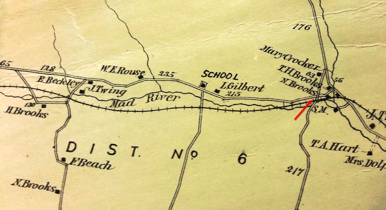
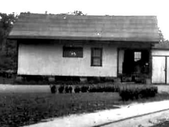
COLEBROOK1 [CW, 1872]
This stop was not on the opening day list in the Courant but by April, 1872 the Winsted Herald said that the new CW milk train had inaugurated stops at BROOKS, as this one was known locally for the nearby families of that name, and SUMMIT, later known as NORFOLK SUMMIT. As such, BROOKS appears on ETT#6 (6/5/1872). The 1880 NY&NE appraisal of CW properties said the small station here was in fair condition and worth $225, which we assume makes it proportionately smaller than the 20x32-ft depot at GRANTS valued at $350. We have found no picture of COLEBROOK1 yet. The location is seen at our red arrow on the 1874 Beers map. [REFS: HDC/12/21/1871/02; WH/04/05/1872/02; HC/06/10/1874/03][rev021418]
This stop was not on the opening day list in the Courant but by April, 1872 the Winsted Herald said that the new CW milk train had inaugurated stops at BROOKS, as this one was known locally for the nearby families of that name, and SUMMIT, later known as NORFOLK SUMMIT. As such, BROOKS appears on ETT#6 (6/5/1872). The 1880 NY&NE appraisal of CW properties said the small station here was in fair condition and worth $225, which we assume makes it proportionately smaller than the 20x32-ft depot at GRANTS valued at $350. We have found no picture of COLEBROOK1 yet. The location is seen at our red arrow on the 1874 Beers map. [REFS: HDC/12/21/1871/02; WH/04/05/1872/02; HC/06/10/1874/03][rev021418]
|
|
|
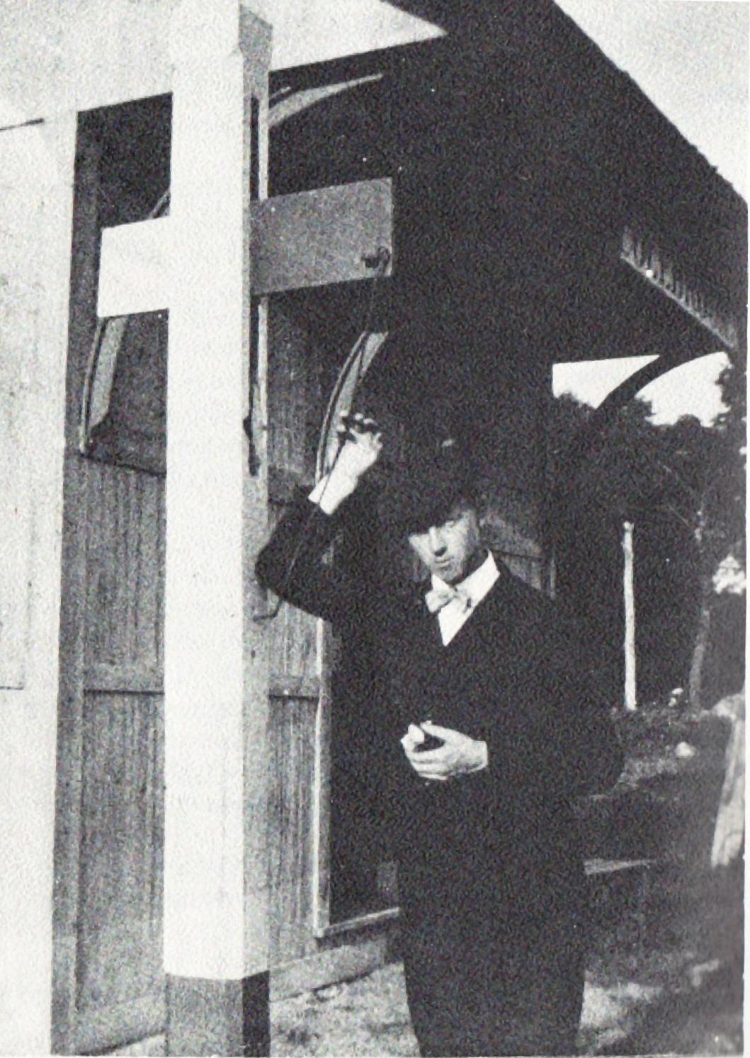
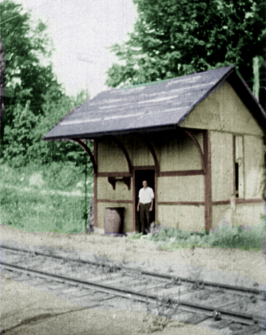
COLEBROOK2 [CNE, 1899]
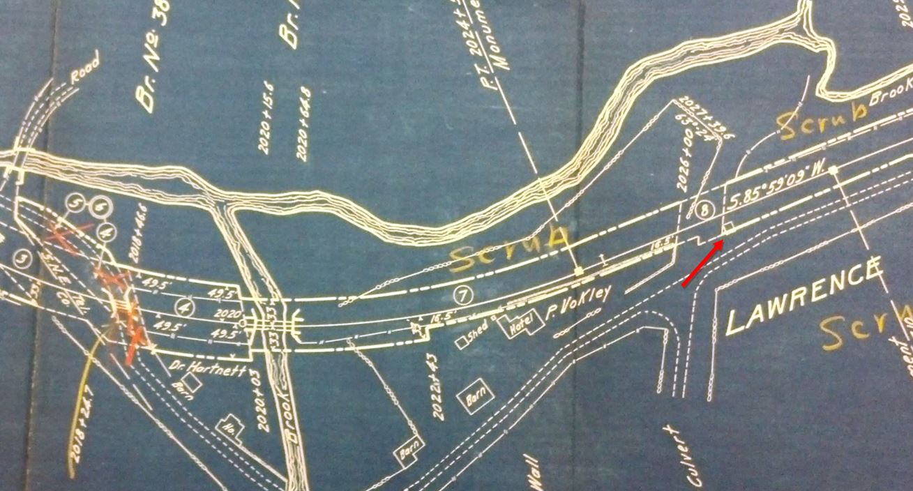
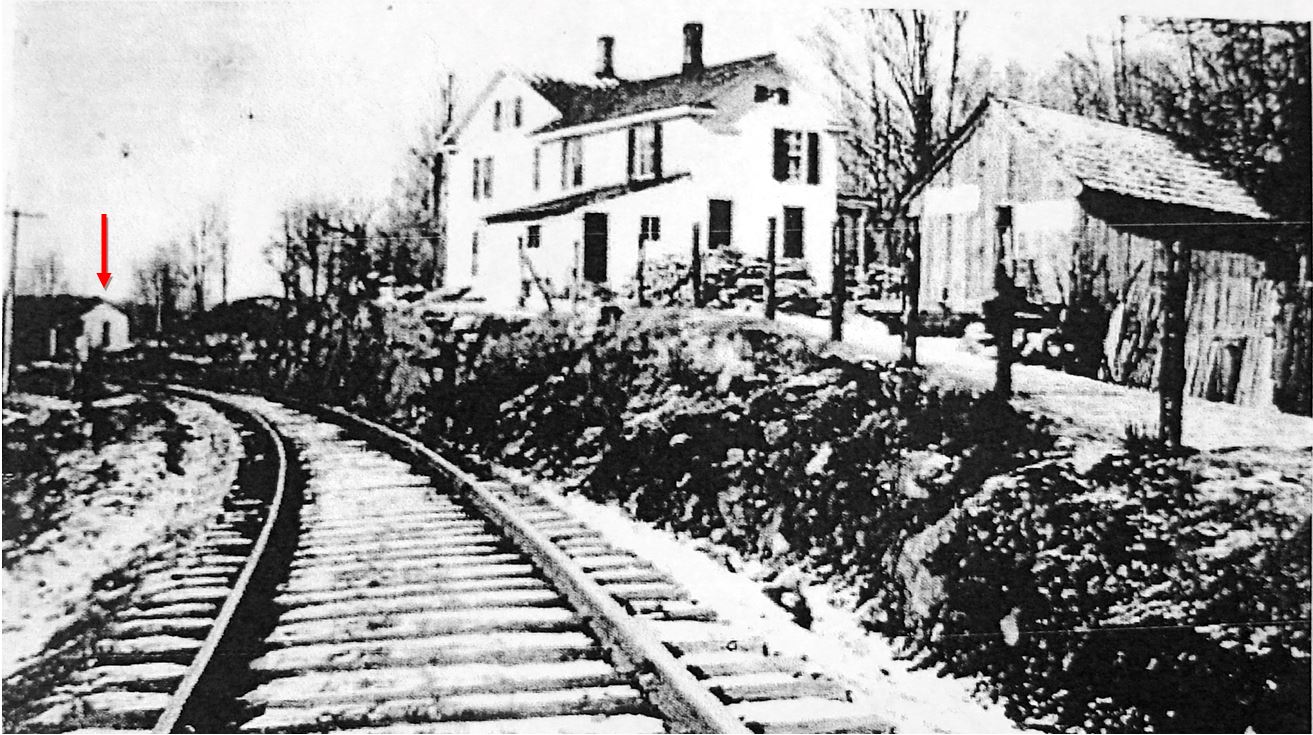
In 1899, the Courant said Superintendent Martin had removed the old depot that had been built by local residents presumably in the early 1870s and had replaced it as he promised with a new one which was roundly praised. The sturdy, sizeable structure with the curved braces must be the replacement seen in these photos. The dapper young man with the half-eaten apple at [1] has pulled the flag-stop mechanism down to let the next train know he is waiting; the name COLEBROOK is visible on the signboard. This station would be renamed per the ICC safety order in 1915 as LAWRENCE for the farm and ice-harvesting operation run in the vicinity by a gentleman of that name. Al Weaver's colorization of the image at [2] brings out the fact that the stop signal has been changed to one with the flag high in the air for better visibility. The identity of the young man in the doorway is unknown but he and the photographer may have been making the rounds of CNE stations on a motorcycle seen in other photos of the era. The 1916 val map at [3] shows the station at our red arrow. The view at [4] shows the shelter in the distance past the large home, probably belonging to Norman Brooks. [REFS: HC/10/11/1899/08; D32; N3.55][rev021418]
In 1899, the Courant said Superintendent Martin had removed the old depot that had been built by local residents presumably in the early 1870s and had replaced it as he promised with a new one which was roundly praised. The sturdy, sizeable structure with the curved braces must be the replacement seen in these photos. The dapper young man with the half-eaten apple at [1] has pulled the flag-stop mechanism down to let the next train know he is waiting; the name COLEBROOK is visible on the signboard. This station would be renamed per the ICC safety order in 1915 as LAWRENCE for the farm and ice-harvesting operation run in the vicinity by a gentleman of that name. Al Weaver's colorization of the image at [2] brings out the fact that the stop signal has been changed to one with the flag high in the air for better visibility. The identity of the young man in the doorway is unknown but he and the photographer may have been making the rounds of CNE stations on a motorcycle seen in other photos of the era. The 1916 val map at [3] shows the station at our red arrow. The view at [4] shows the shelter in the distance past the large home, probably belonging to Norman Brooks. [REFS: HC/10/11/1899/08; D32; N3.55][rev021418]

|
|
|
|

|
|
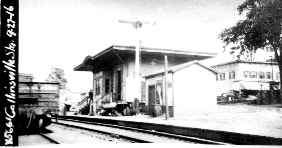
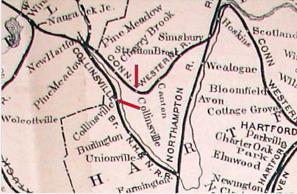
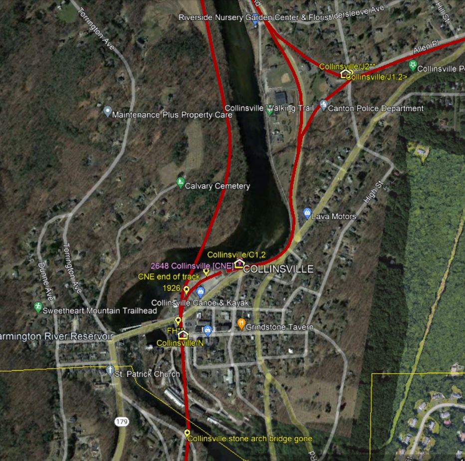
COLLINSVILLE/N [NH&N, 1850]
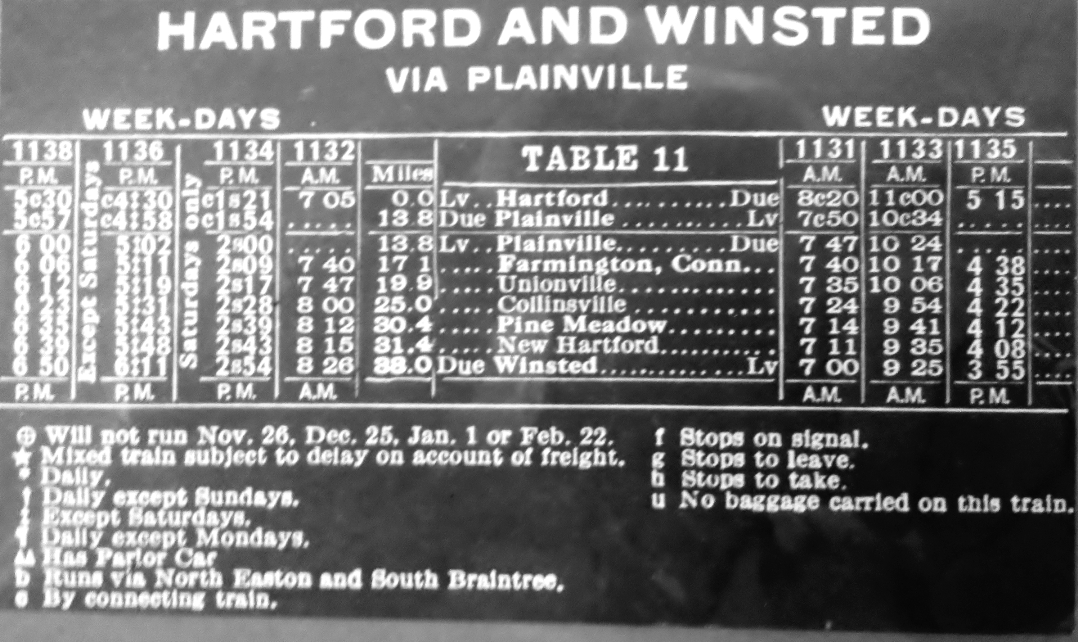
This station in the town of CANTON was designed in a somewhat whimsical style by Henry Austin, noted New Haven architect who is known for the city hall building we still have in the Elm City today as well as many other landmark structures in the state. This depot was one of the trio of Canal road stations that he designed. The others were the much larger and more ornate Elm City 1848 Union Station, our NEW HAVEN3, and the simple PLAINVILLE1 for the other Canal road terminus in 1850. According to the annual report for 1850, trains were running to this station by February of that year and it would be the terminus of this NH&N branch until it was extended to PINE MEADOW in 1870, later to NEW HARTFORD in 1876. The image at [1] shows the layout here in 1868, with the station at the red arrow. The extensive buildings of the Collins Co., the well-known maker of cutting tools and the village's major employer and namesake, are to the south. In fact, Samuel Collins was instrumental in getting the Canal line to build the branch to service his factory and donated the land for the railroad station. The image at [2] is from the 1878 Bailey birds-eye map. The station's actual appearance agrees with the architect's rendering at [3]. The cupola, still seen on the roof in 1878, is gone in later photographs. By 1889, the "unsightly, inconvenient and unclean" conditions here prompted a petition to the railroad commissioners for a new depot, which they recommended but were not empowered by statute to order. A Courant article said repairs were underway here in 1904 and that a "bay window will also be added on the side facing the track." It is seen on the 9/27/1916 valuation photo at [4]. The 3/10/1924 PUC photo at [5] apparently shows the street side of the station. When service on the CNE was being curtailed, trains from Hartford to Winsted began using an NY&NE/Canal line routing via Plainville to Pine Meadow, where they regained CNE trackage. The 12/7/1925 schedule at [6] shows this routing, which made COLLINSVILLE/N the first and last station to serve passengers in this community. Formerly it was thought that this depot was carried away by the floods of 1955 but a Fortune magazine article shows photographs of the station site bereft of station in January, 1946. The photographer was none other than Walker Evans! Local speculation is that the end of CNE passenger service in 1927 opened the door for the Collins Co. to purchase the land for its flourishing business. Land records and/or newspapers would have to be consulted to verify that. Thanks to Bill Volovski of Collinsville for bringing this to our attention. [REFS: NHNAR14.1850.5; RRC24.155 (11/11/1889); HDC/06/28/1904/15; D18][rev090319, 021320]
This station in the town of CANTON was designed in a somewhat whimsical style by Henry Austin, noted New Haven architect who is known for the city hall building we still have in the Elm City today as well as many other landmark structures in the state. This depot was one of the trio of Canal road stations that he designed. The others were the much larger and more ornate Elm City 1848 Union Station, our NEW HAVEN3, and the simple PLAINVILLE1 for the other Canal road terminus in 1850. According to the annual report for 1850, trains were running to this station by February of that year and it would be the terminus of this NH&N branch until it was extended to PINE MEADOW in 1870, later to NEW HARTFORD in 1876. The image at [1] shows the layout here in 1868, with the station at the red arrow. The extensive buildings of the Collins Co., the well-known maker of cutting tools and the village's major employer and namesake, are to the south. In fact, Samuel Collins was instrumental in getting the Canal line to build the branch to service his factory and donated the land for the railroad station. The image at [2] is from the 1878 Bailey birds-eye map. The station's actual appearance agrees with the architect's rendering at [3]. The cupola, still seen on the roof in 1878, is gone in later photographs. By 1889, the "unsightly, inconvenient and unclean" conditions here prompted a petition to the railroad commissioners for a new depot, which they recommended but were not empowered by statute to order. A Courant article said repairs were underway here in 1904 and that a "bay window will also be added on the side facing the track." It is seen on the 9/27/1916 valuation photo at [4]. The 3/10/1924 PUC photo at [5] apparently shows the street side of the station. When service on the CNE was being curtailed, trains from Hartford to Winsted began using an NY&NE/Canal line routing via Plainville to Pine Meadow, where they regained CNE trackage. The 12/7/1925 schedule at [6] shows this routing, which made COLLINSVILLE/N the first and last station to serve passengers in this community. Formerly it was thought that this depot was carried away by the floods of 1955 but a Fortune magazine article shows photographs of the station site bereft of station in January, 1946. The photographer was none other than Walker Evans! Local speculation is that the end of CNE passenger service in 1927 opened the door for the Collins Co. to purchase the land for its flourishing business. Land records and/or newspapers would have to be consulted to verify that. Thanks to Bill Volovski of Collinsville for bringing this to our attention. [REFS: NHNAR14.1850.5; RRC24.155 (11/11/1889); HDC/06/28/1904/15; D18][rev090319, 021320]
Canton Historical Society
|
|
|
COLLINSVILLE/J1 [CW, 1872]
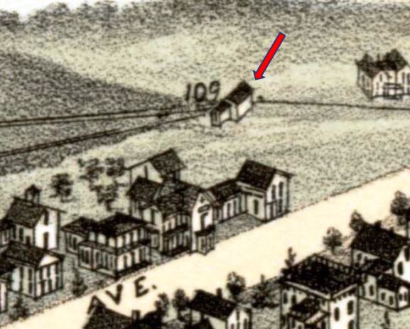
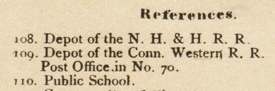
This station was the first of two at the junction, this one in place soon just after the CW opened in 1871. The '/J' is our designation for the stations here. The RRM at [2] shows two dots for this village. The one to the left is for COLLINSVILLE/N on the Canal line where the actual village was and the one at the red arrow shows where the CW line passed, about a half mile above the village center. On the opening of the CW late in 1871, the paper said that, in spite of the small inconvenience of having to go the half mile north to take the train, there was rejoicing now that "we can go direct to Hartford without the detentions as heretofore by the south route [via Plainville on the Canal line]." It continued by saying that "The completion of the short branch road to our village will be a great accommodation to our citizens, and add much to the business of the road." That branch, as we will see, did not come until early 1875 and to ameliorate the situation the Herald reported a few days later in January, 1872 that "The Conn. Western has engaged Joseph B. Dewey [as station agent] to convey passengers from our village to their road at the Y, half a mile, without additional cost. Jenison Grow carries the express [mail and small packages] to and from the above road." In addition, it said that "The Conn. Western R. R. Co. have purchased of S.V. Woodbridge, the building for many years occupied as a shoemaker's shop on North street, and have removed it to the Y half-a-mile mile above our village, where it is to be used this winter as a waiting room for passengers. This building is about 14x20 and was originally used as a whip and cigar shop, [a Westfield, Mass. venture] and has since been used alternately as a lawyer's office, shoemaker's shop, and more recently as a market." The "winter" proved to be a decade of discontent! The 1880 NY&NE appraisal of CW property said there was a station here to serve both passengers and freight valued at $100, the same value as the small structure at CHERRY BROOK. The old shop was still in use as the depot in 1882, when the newspaper said "that they couldn't add any more panes [make any more repairs?] to the old wreck" and later that "It's a shame for any road to have on its line even a flag station so mean in appearance as the little coop called a depot by the H. and Conn. western railroad company." We had discounted the image of the station on the 1878 Bailey bird's-eye map at [3] many years ago because it did not jibe with the photos understood to be COLLINSVILLE/J2 that we once thought were of the first station here. And now we know why. Mr. Bailey sketched the shoemaker-shop-turned-depot seen at locator number 109 and in the index image at [4] which shows the two stations. Bailey's representation matches the shape and even the orientation of the building. It is seen with signboard and trackside platform in the photo at [1], which we found purely by chance at the Canton Historical Society and immediately brought to their attention. The paper made a comment prior to the opening of this station's replacement, COLLINSVILLE/J2, that "the new passenger depot of the Hartford & Conn. Western will be entered from the south end, and not a broadside on passengers as heretofore." Apparently the door that we see was the only one and the building was positioned this way for access to the track, the closeness of which created some danger. When the "beautiful upper and lower depots" were newly completed in 1886, the CWN said that "old upper depot was bought by Wm. L. Shook and torn down," presumably, as was often done, for the lumber and other salvageable materials. [REFS: HDC/12/21/1871/02; WH/12/29/1871/02; WH/01/05/1872/02; CW/NYNE1880; WH/07/06/1882/00; WH/08/17/1882 /00; WH/10/26/1882/00; WH/11/23/1882/00; WH/03/26/1886/02; CWN/07/14/1886/02][rev100301, 112318, 090319, 070222]
This station was the first of two at the junction, this one in place soon just after the CW opened in 1871. The '/J' is our designation for the stations here. The RRM at [2] shows two dots for this village. The one to the left is for COLLINSVILLE/N on the Canal line where the actual village was and the one at the red arrow shows where the CW line passed, about a half mile above the village center. On the opening of the CW late in 1871, the paper said that, in spite of the small inconvenience of having to go the half mile north to take the train, there was rejoicing now that "we can go direct to Hartford without the detentions as heretofore by the south route [via Plainville on the Canal line]." It continued by saying that "The completion of the short branch road to our village will be a great accommodation to our citizens, and add much to the business of the road." That branch, as we will see, did not come until early 1875 and to ameliorate the situation the Herald reported a few days later in January, 1872 that "The Conn. Western has engaged Joseph B. Dewey [as station agent] to convey passengers from our village to their road at the Y, half a mile, without additional cost. Jenison Grow carries the express [mail and small packages] to and from the above road." In addition, it said that "The Conn. Western R. R. Co. have purchased of S.V. Woodbridge, the building for many years occupied as a shoemaker's shop on North street, and have removed it to the Y half-a-mile mile above our village, where it is to be used this winter as a waiting room for passengers. This building is about 14x20 and was originally used as a whip and cigar shop, [a Westfield, Mass. venture] and has since been used alternately as a lawyer's office, shoemaker's shop, and more recently as a market." The "winter" proved to be a decade of discontent! The 1880 NY&NE appraisal of CW property said there was a station here to serve both passengers and freight valued at $100, the same value as the small structure at CHERRY BROOK. The old shop was still in use as the depot in 1882, when the newspaper said "that they couldn't add any more panes [make any more repairs?] to the old wreck" and later that "It's a shame for any road to have on its line even a flag station so mean in appearance as the little coop called a depot by the H. and Conn. western railroad company." We had discounted the image of the station on the 1878 Bailey bird's-eye map at [3] many years ago because it did not jibe with the photos understood to be COLLINSVILLE/J2 that we once thought were of the first station here. And now we know why. Mr. Bailey sketched the shoemaker-shop-turned-depot seen at locator number 109 and in the index image at [4] which shows the two stations. Bailey's representation matches the shape and even the orientation of the building. It is seen with signboard and trackside platform in the photo at [1], which we found purely by chance at the Canton Historical Society and immediately brought to their attention. The paper made a comment prior to the opening of this station's replacement, COLLINSVILLE/J2, that "the new passenger depot of the Hartford & Conn. Western will be entered from the south end, and not a broadside on passengers as heretofore." Apparently the door that we see was the only one and the building was positioned this way for access to the track, the closeness of which created some danger. When the "beautiful upper and lower depots" were newly completed in 1886, the CWN said that "old upper depot was bought by Wm. L. Shook and torn down," presumably, as was often done, for the lumber and other salvageable materials. [REFS: HDC/12/21/1871/02; WH/12/29/1871/02; WH/01/05/1872/02; CW/NYNE1880; WH/07/06/1882/00; WH/08/17/1882 /00; WH/10/26/1882/00; WH/11/23/1882/00; WH/03/26/1886/02; CWN/07/14/1886/02][rev100301, 112318, 090319, 070222]

|

|

|
|
|
|

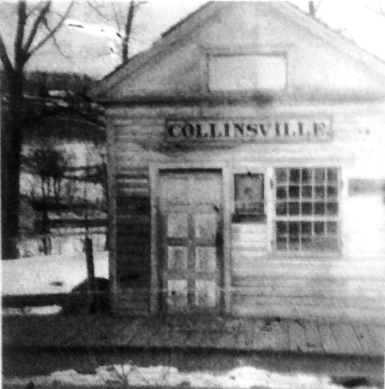
COLLINSVILLE/J2 [H&CW, 1886]
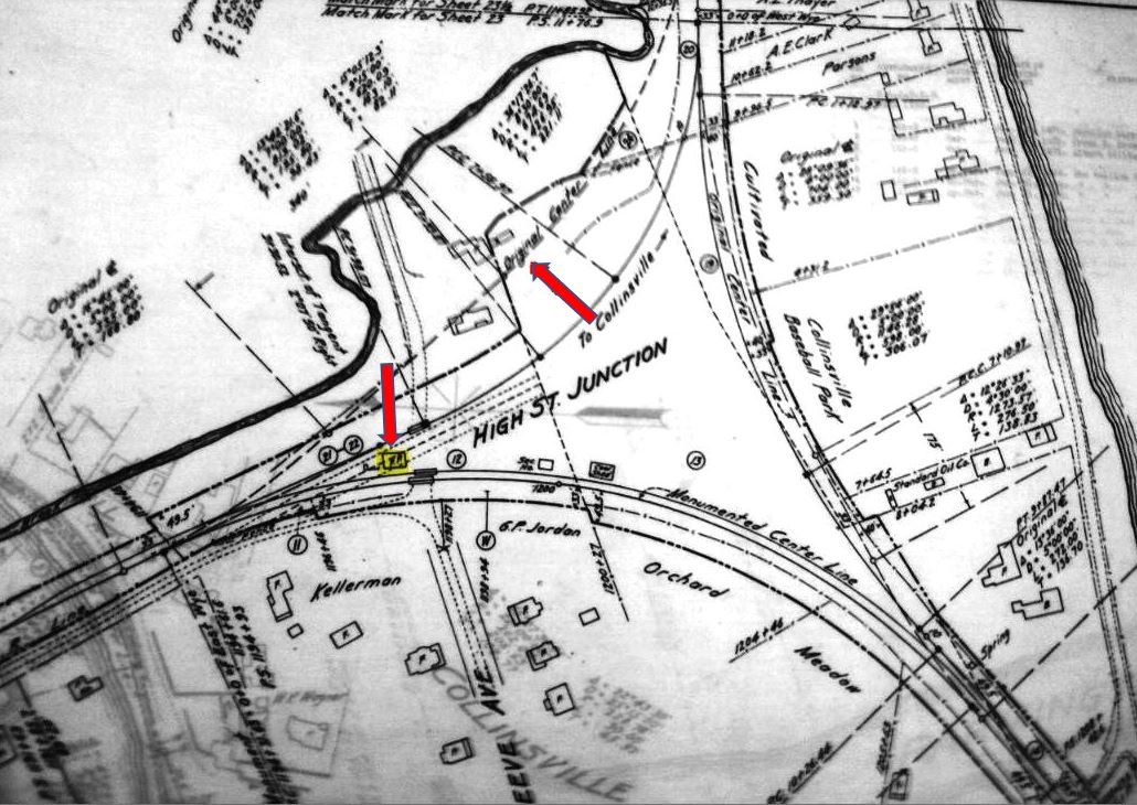
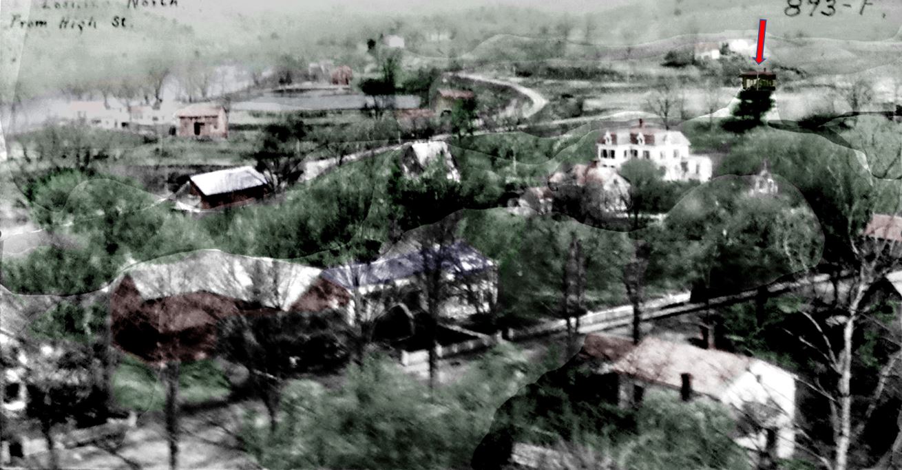
After over a decade of continual public complaint about the condition of all the village railroad stations, the Winsted Herald said in March, 1886 that "It is now confidently expected that there will be a new upper and lower passenger depot on the Hartford & Connecticut Western railroad" and a week later the newspaper reported that "several workmen are rapidly pushing forward the work." By the end of April, the news was that "the most noticeable improvements hereabouts are the new lower and upper depots of the Hartford and C.W.R.R. which our citizens and the traveling public will appreciate." The profile of this new 'upper depot' structure is similar to the Austin station, COLLINSVILLE/N1, and may have been deliberately designed to mirror it, especially since this was the timetable stop and the town's official railroad depot where people took the 'real' train, not the horse car seen in our next entry. The image at [1] is probably from the early 1900s or earlier when the horse and wagon went down to the station to retrieve freight. The photo at [2] shows the junction looking west on 10/27/1927 in what may be an edited PUC shot; the single line curving south into Collinsville and the main line and passing siding curving north to follow the Farmington River up to Satan's Kingdom and Pine Meadow. The shot at [3] shows the depot moved south, having been purchased by the town in April, 1930 to be used as a storage facility; passenger service ended in 1927. The mid-roof peaks are still visible but now the building is fitted up with garage doors and refuse pipes are seen on the ground. Nimke [3-115] dates this photo to the late 1930s or early 1940s. The valuation map at [4] shows the arrangement in 1916. Called HIGH STREET JUNCTION as of 1915, the depot is highlighted in yellow and the red arrow points to the original line of the wye track to the village center. The undated aerial photo at [5] looks northwest, with the Collinsville wye stretched out along the river. The red arrow points to where Al Weaver has placed it in the wye. Although forlorn, the 20x32-ft building with 6- to 10-ft overhanging eaves, still stands at 9 Dyer Ave. in 2022 after 130+ years, as seen at [6]. The peaks have been cut off to create a simple hipped roof. The red arrows on the 1893 map at [7] show the three locations: COLLINSVILLE/J1,J2 [top], COLLINSVILLE/C1,C2 [middle], and COLLINSVILLE/N [bottom]. A town preservation effort in 2022 is set to restore this station and move it a short distance to the nearby Farmington River Trail, which follows the right of way of the old CW, later the CNE, to Canton Center. This is very exciting news! [REFS: HDC/12/21/1871/02; HDC/05/19/1873/01; HDC/06/04/1873/03; HDC/07/29/1873/04; HDC/05/20/1874/04; WH/03/12/1886/02; WH/03/19/1886/02; WH/04/30/1886/02; CWN/07/14/1886/02; HDC/09/16/1896/08; SR/10/08/1902/12; HDC/04/23/1910/11; FVH/04/24/1930/01; RRM228; D22; R60][rev100212, 112618, 090319, 063022]
After over a decade of continual public complaint about the condition of all the village railroad stations, the Winsted Herald said in March, 1886 that "It is now confidently expected that there will be a new upper and lower passenger depot on the Hartford & Connecticut Western railroad" and a week later the newspaper reported that "several workmen are rapidly pushing forward the work." By the end of April, the news was that "the most noticeable improvements hereabouts are the new lower and upper depots of the Hartford and C.W.R.R. which our citizens and the traveling public will appreciate." The profile of this new 'upper depot' structure is similar to the Austin station, COLLINSVILLE/N1, and may have been deliberately designed to mirror it, especially since this was the timetable stop and the town's official railroad depot where people took the 'real' train, not the horse car seen in our next entry. The image at [1] is probably from the early 1900s or earlier when the horse and wagon went down to the station to retrieve freight. The photo at [2] shows the junction looking west on 10/27/1927 in what may be an edited PUC shot; the single line curving south into Collinsville and the main line and passing siding curving north to follow the Farmington River up to Satan's Kingdom and Pine Meadow. The shot at [3] shows the depot moved south, having been purchased by the town in April, 1930 to be used as a storage facility; passenger service ended in 1927. The mid-roof peaks are still visible but now the building is fitted up with garage doors and refuse pipes are seen on the ground. Nimke [3-115] dates this photo to the late 1930s or early 1940s. The valuation map at [4] shows the arrangement in 1916. Called HIGH STREET JUNCTION as of 1915, the depot is highlighted in yellow and the red arrow points to the original line of the wye track to the village center. The undated aerial photo at [5] looks northwest, with the Collinsville wye stretched out along the river. The red arrow points to where Al Weaver has placed it in the wye. Although forlorn, the 20x32-ft building with 6- to 10-ft overhanging eaves, still stands at 9 Dyer Ave. in 2022 after 130+ years, as seen at [6]. The peaks have been cut off to create a simple hipped roof. The red arrows on the 1893 map at [7] show the three locations: COLLINSVILLE/J1,J2 [top], COLLINSVILLE/C1,C2 [middle], and COLLINSVILLE/N [bottom]. A town preservation effort in 2022 is set to restore this station and move it a short distance to the nearby Farmington River Trail, which follows the right of way of the old CW, later the CNE, to Canton Center. This is very exciting news! [REFS: HDC/12/21/1871/02; HDC/05/19/1873/01; HDC/06/04/1873/03; HDC/07/29/1873/04; HDC/05/20/1874/04; WH/03/12/1886/02; WH/03/19/1886/02; WH/04/30/1886/02; CWN/07/14/1886/02; HDC/09/16/1896/08; SR/10/08/1902/12; HDC/04/23/1910/11; FVH/04/24/1930/01; RRM228; D22; R60][rev100212, 112618, 090319, 063022]
|
|
|
|
|
|
COLLINSVILLE/C1 [CW, 1874]
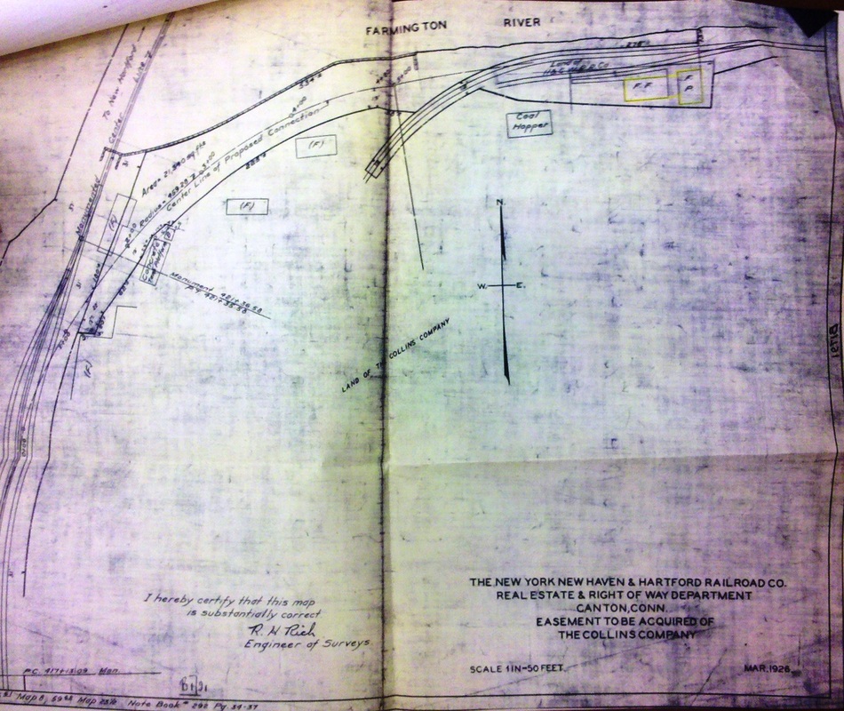
The stations designated '/C' are the ones that stood in the village center at River and Bridge Sts. The fact that the wye is mentioned in reports about the opening of the road shows that the railroad intended from the start to build a spur from the junction. On 11/15/1873, the Connecticut Courant quoted a Winsted paper saying that the 'Y' into Collinsville would be completed in two weeks, all trains thereafter would run down to the village, and passenger trains would back down and come out head first. The CWN reported on 12/26/1873 that "... the branch of the Conn. Western rail road from the Y to Collinsville is now completed past the old hotel..." As it turned out, it was only used initially for freight trains because in the middle of 1874 people were still complaining about having to take the open carriage up to the junction. By December, 1874, the paper said "the road is now ready and the new depot built." The rare photos at [1] and [2] are parts of a composite, the first showing this station at the River St. location with a horse car standing beside it and the second an interior shot of the depot. The hand-written captioning says, in part, that the station was "Made over from stable at Old Hotel... It was later used for freight only." The image at [3] is from the 1878 Bailey map. Like COLLINSVILLE/J1 above, we had thought the artist erred because the image did not match the east-west orientation and roof line of the station we have now listed as COLLINSVILLE/C2. And the photo again proves why: Bailey was sketching COLLINSVILLE/C1 and caught the horse car in action to boot! And, interestingly, there is no locator number and no listing in the map key for this structure. Why? The only reason we can offer is because it was not thought of as a real town depot like the one at the junction. The photo at [4] shows this station as the freight depot in 1934. The spur that we see dead-ending here would later be lengthened to connect with the Canal line. Nimke says this was done some time between 1905 and 1910 but the 1916 val map at [5] shows the spur from the junction still dead-ending here. An April, 1926 article we dug out of the Farmington Valley Herald finally answered this nagging question when it reported that "Work is underway connecting the tracks of the [Northampton] Branch railroad and the Central New England in Collinsville. That is something that should have been done long ago as by doing this at least six miles of tracks can be discontinued and for the last mile and a half into New Hartford the tracks have always been side by side." The March, 1926 map at [6] shows the proposed connection. The newspaper's point is well taken, especially in light of the fact that a 1925 article said that Canton customers were being served by a freight from Winsted that went in reverse all the way back to Pine Meadow to then switch over to the Canal line and serve customers down to Plainville! Canton, of course, was still a money-maker for the railroad, especially with the Gra-Rock Co. there being the third-largest beverage producer in the nation. In 1927, it reportedly turned out 21,000,000 bottles of products like spring water, said in 1914 to be "the purest water that nature has ever produced," plus soft drinks and flavorings. ICC permission was granted in 1932 to abandon service from .25 miles east of High Street Jct. to Pine Meadow but trackage was left in place, the wye still being used for the turning of trains. All track was abandoned in 1938 and pulled up by 9/28/1939. It is unclear when Gra-Rock stopped getting service but by 1928 it had purchased the National Machine Co. plant in Wethersfield to expand and consolidate operations there. [REFS: WH/02/07/1873/03; HDC/11/11/1873/04; CC/11/15/1873/04; HDC/11/19/1873/04; CWN/07/17/1874/02; CWN/11/06/1874/02; HDC/11/25/1874/04; CWN/12/11/1874/02; CWN/01/08/1875/02; WH/01/08/1875/02; WH/01/15/1875/02; WH/01/22/1875/02; CWN/01/29/1875/02; HDC/09/16/1896/08; HC/08/02/1914/13; FVH/06/18/1925/07; FVH/04/22/1926/03; HC/06/24/1928/B7; HC/06/30/1932/07; 187 ICC 361 (1932); 228 ICC 193 (1938); N3.27; Canton, Connecticut, 1806-2006, p58][rev113018, 121718, 090319, 063022]
The stations designated '/C' are the ones that stood in the village center at River and Bridge Sts. The fact that the wye is mentioned in reports about the opening of the road shows that the railroad intended from the start to build a spur from the junction. On 11/15/1873, the Connecticut Courant quoted a Winsted paper saying that the 'Y' into Collinsville would be completed in two weeks, all trains thereafter would run down to the village, and passenger trains would back down and come out head first. The CWN reported on 12/26/1873 that "... the branch of the Conn. Western rail road from the Y to Collinsville is now completed past the old hotel..." As it turned out, it was only used initially for freight trains because in the middle of 1874 people were still complaining about having to take the open carriage up to the junction. By December, 1874, the paper said "the road is now ready and the new depot built." The rare photos at [1] and [2] are parts of a composite, the first showing this station at the River St. location with a horse car standing beside it and the second an interior shot of the depot. The hand-written captioning says, in part, that the station was "Made over from stable at Old Hotel... It was later used for freight only." The image at [3] is from the 1878 Bailey map. Like COLLINSVILLE/J1 above, we had thought the artist erred because the image did not match the east-west orientation and roof line of the station we have now listed as COLLINSVILLE/C2. And the photo again proves why: Bailey was sketching COLLINSVILLE/C1 and caught the horse car in action to boot! And, interestingly, there is no locator number and no listing in the map key for this structure. Why? The only reason we can offer is because it was not thought of as a real town depot like the one at the junction. The photo at [4] shows this station as the freight depot in 1934. The spur that we see dead-ending here would later be lengthened to connect with the Canal line. Nimke says this was done some time between 1905 and 1910 but the 1916 val map at [5] shows the spur from the junction still dead-ending here. An April, 1926 article we dug out of the Farmington Valley Herald finally answered this nagging question when it reported that "Work is underway connecting the tracks of the [Northampton] Branch railroad and the Central New England in Collinsville. That is something that should have been done long ago as by doing this at least six miles of tracks can be discontinued and for the last mile and a half into New Hartford the tracks have always been side by side." The March, 1926 map at [6] shows the proposed connection. The newspaper's point is well taken, especially in light of the fact that a 1925 article said that Canton customers were being served by a freight from Winsted that went in reverse all the way back to Pine Meadow to then switch over to the Canal line and serve customers down to Plainville! Canton, of course, was still a money-maker for the railroad, especially with the Gra-Rock Co. there being the third-largest beverage producer in the nation. In 1927, it reportedly turned out 21,000,000 bottles of products like spring water, said in 1914 to be "the purest water that nature has ever produced," plus soft drinks and flavorings. ICC permission was granted in 1932 to abandon service from .25 miles east of High Street Jct. to Pine Meadow but trackage was left in place, the wye still being used for the turning of trains. All track was abandoned in 1938 and pulled up by 9/28/1939. It is unclear when Gra-Rock stopped getting service but by 1928 it had purchased the National Machine Co. plant in Wethersfield to expand and consolidate operations there. [REFS: WH/02/07/1873/03; HDC/11/11/1873/04; CC/11/15/1873/04; HDC/11/19/1873/04; CWN/07/17/1874/02; CWN/11/06/1874/02; HDC/11/25/1874/04; CWN/12/11/1874/02; CWN/01/08/1875/02; WH/01/08/1875/02; WH/01/15/1875/02; WH/01/22/1875/02; CWN/01/29/1875/02; HDC/09/16/1896/08; HC/08/02/1914/13; FVH/06/18/1925/07; FVH/04/22/1926/03; HC/06/24/1928/B7; HC/06/30/1932/07; 187 ICC 361 (1932); 228 ICC 193 (1938); N3.27; Canton, Connecticut, 1806-2006, p58][rev113018, 121718, 090319, 063022]
|
Canton Historical Society
|
Archives & Special Collections, UConn
|
|

Robert Lingane Collection
|
|
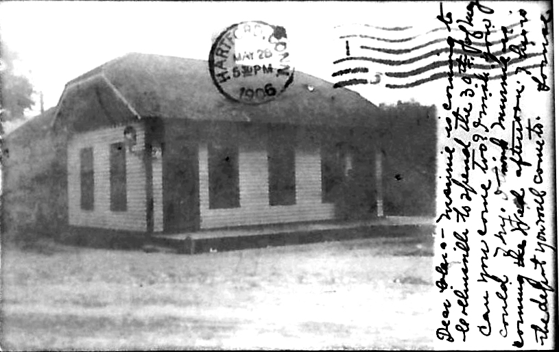
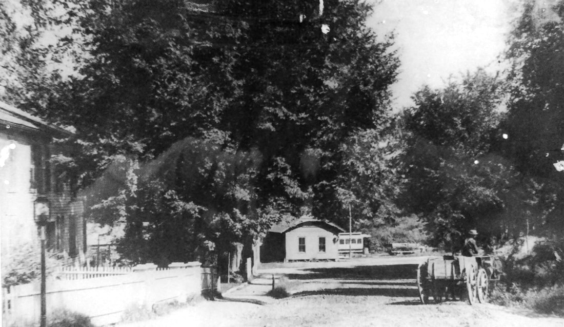
COLLINSVILLE/C2 [H&CW, 1886]
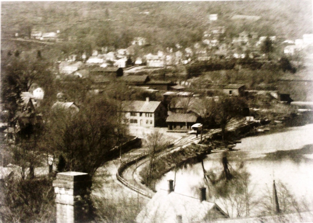
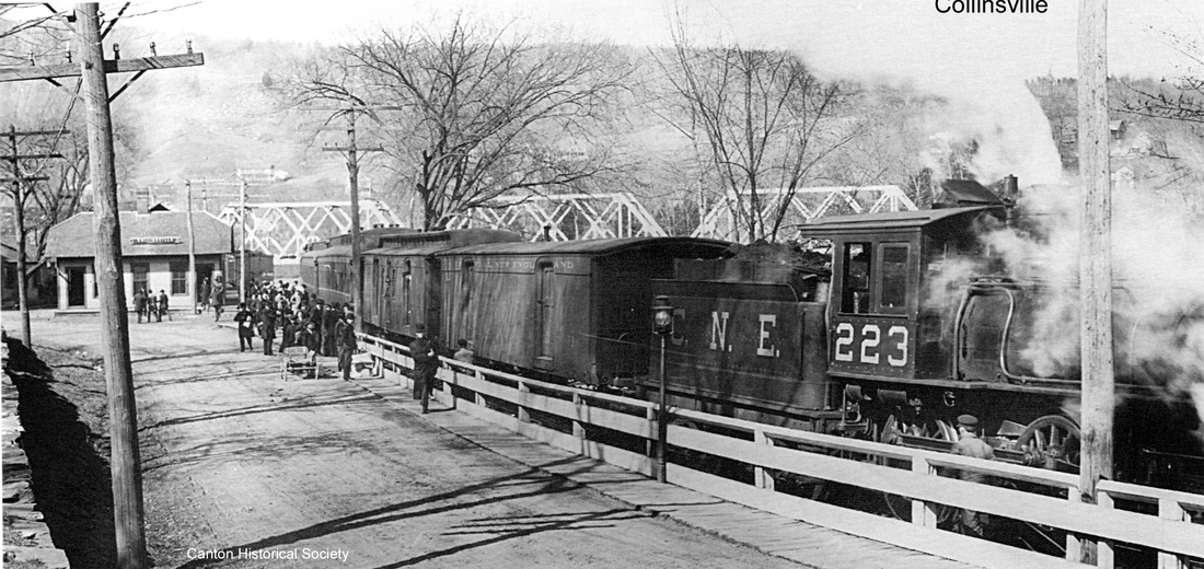
This station was built in 1886 at the same time as COLLINSVILLE/J2, its cousin to the north. The card at [1] is postmarked 1906 and is the earliest close-up view we have been able to date with certainty. The photo at [2] is a wonderful aerial view of this station, again showing the horse car. The image at [3], another fortunate find, has a caption date (not shown) of 1871. That date must apply to the opening of the CW because but is not correct for the scene because, as shown above, the spur that the horse car is sitting on was not completed until late 1874 and this station was built in 1886. Immediately after this station's predecessor, COLLINSVILLE/C1, was fashioned from the old hotel stable, the "long-expected horse car" to replace the open carriage arrived in January, 1875 and the Mills Brothers "put a large horse on the track to draw the horse car." Dewey had been succeeded as station agent in March, 1873 by Franklin M. Mills, who died in 1910 after nearly forty years with the railroad. Like his predecessor, Mills did the driving at first. When the shuttling back and forth and the hectic pace of tending to two stations became too much, the CW permitted Mills to hire his brother, Washburn G. (Will) Mills, to take the reins. The horse car service was always well-patronized, even by locals not intending to take the train, and why not? No fares were ever charged and kids just hung on for the ride, the latter often scolded by Will for their unruly behavior! The uniquely colorful horse-car arrangement lasted until the then-PR&NE laid heavier rail and began backing passenger trains down to 'the lower depot.' This appears to have started in December, 1893, when the Winsted Herald said that "the P.R. & N.E. run trains into Collinsville and this pleases the people of that place more than the through passengers." This debut of steam banished the venerable horse car, reportedly to the West Winsted engine house, and timetables thereafter show two stops here: this station as COLLINSVILLE, plus the one at the wye now called COLLINSVILLE JUNCTION and the junction now mostly listed as a flag stop. Once the village got steam passenger service to the lower depot, any attempts to cut it back were met with objection from the public. The photo at [4] shows steam service on the spur and dates after 1907 when the 223 was renumbered as such by the CNE. The 4/12/1934 valuation photo at [5] looks westward, showing COLLINSVILLE/C1 as the freight house behind COLLINSVILLE/C2. CNE passenger service ended in 1927. These buildings were all destroyed in the 1955 floods, thus erasing much of the structural evidence of this village's railroad history. The snippet at [6] is from our Track 12 Google Earth map and shows all the locations in this 'railroad town' which is among the most fascinating in the state
[REFS: HDC/05/20/1874/04; HDC/06/13/1874/04; WH/12/29/1893/03; HDC/09/16/1896/08; CNE ETT16 (11/17/1898); HDC/08/25/1905/14; HDC/09/29/1905/14; HDC/09/11/1907/13; HDC/06/14/1907/15; HDC/06/25/1907/18; Fisher, SL128; K115; N3.27][rev120212, 112818, 063022]
COLLINSVILLE JUNCTION [> COLLINSVILLE/J1,2]
COLTS DYKE [> HARTFORD3]
COLUMBIA JUNCTION [> AIR LINE JUNCTION]
COLTS DYKE [> HARTFORD3]
COLUMBIA JUNCTION [> AIR LINE JUNCTION]

|

|
|
CONNECTICUT RIVER1
[NH&NL, 1852]
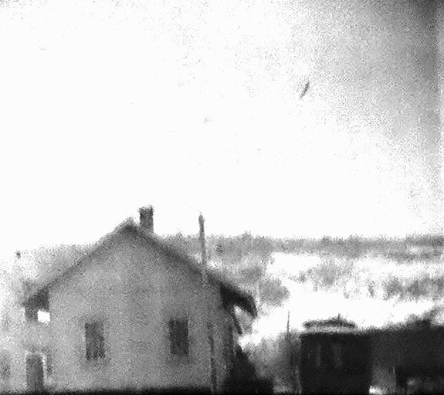
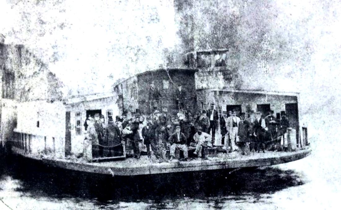
As seen on the 1859MC map at [1] and the real estate atlas at [2], this was an original station in Old Saybrook on the NH&NL, whose first train ran to here on 6/30/1852. The depot was located on the river's western bank at the ferry terminus where boats carried trains to Old Lyme until a bridge was built in 1870. The first train passed over the completed structure on 6/4/1870. Estimates were that the bridge would save 15 to 20 minutes over the crossing by boat. The Shaumpishus, pictured at [3], carried passengers and railroad cars to locomotives waiting on the opposite shore and was put out of business when the bridge opened. According to the newspaper, a large party went out on a special train from New Haven on 6/11/1870 "and fired a cork salute in celebration of the event." The article went on to say, perhaps pointedly, that "Nobody from Hartford was invited." Perhaps the reason was the controversy that surrounded the construction of this bridge which was not built to the highest standards. The railroad commissioners rather lamely reported that they had issued no certificate of suitability to operate trains over the new structure since "no application was made to them on the part of the company before opening the bridge to public travel." In light of the Norwalk drawbridge disaster of 1853, which was the direct cause for the creation of the Board of Railroad Commissioners, this would seem to amount to negligence on their part, though they were limited by statute as to what they could order. A scant two years later, the newspaper said important changes were being made to the right of way between here and the LYME station on the opposite bank. The length of the curved approach on both sides of the river was being shortened and "a new pier is being built on the Lyme side of the river." Lingering concerns about the bridge finally caused an investigation by the railroad commissioners. This included the hiring, seemingly extraordinary for the times, of a "submarine engineer and diver," George W. Fuller, whose report was dated 9/27/1875. It said that the east abutment was in "a very unsafe condition" and the west abutment was "never properly constructed" and "in a very dangerous condition." The commissioners communicated this information and some corrective steps were taken by the railroad which did not think things were as bad as Fuller said. A February 1872 newspaper schedule reveals that this stop had more uses than just boarding the ferry. Carriages met trains at this first station west of the river to bring them to inland towns like Essex, Deep River and Chester. [REFS: NLDC/07/03/1852/02; PTH107.1858.13; HDC/07/31/1863/02; HDC/04/21/1870/04; HDC/05/20/1870/04; HDC/06/06/1870/03; NLD/06/11/1870/01; HDC/06/13/1870/02; PEP/06/13/1870/03; NHJC/02/24/1872/04; MC/08/28/1872/02; MC/10/23/1872/02; DC/05/05/1876/02; CRC23.1876. 21,40+][rev022413, 111518, 103120]
[NH&NL, 1852]
As seen on the 1859MC map at [1] and the real estate atlas at [2], this was an original station in Old Saybrook on the NH&NL, whose first train ran to here on 6/30/1852. The depot was located on the river's western bank at the ferry terminus where boats carried trains to Old Lyme until a bridge was built in 1870. The first train passed over the completed structure on 6/4/1870. Estimates were that the bridge would save 15 to 20 minutes over the crossing by boat. The Shaumpishus, pictured at [3], carried passengers and railroad cars to locomotives waiting on the opposite shore and was put out of business when the bridge opened. According to the newspaper, a large party went out on a special train from New Haven on 6/11/1870 "and fired a cork salute in celebration of the event." The article went on to say, perhaps pointedly, that "Nobody from Hartford was invited." Perhaps the reason was the controversy that surrounded the construction of this bridge which was not built to the highest standards. The railroad commissioners rather lamely reported that they had issued no certificate of suitability to operate trains over the new structure since "no application was made to them on the part of the company before opening the bridge to public travel." In light of the Norwalk drawbridge disaster of 1853, which was the direct cause for the creation of the Board of Railroad Commissioners, this would seem to amount to negligence on their part, though they were limited by statute as to what they could order. A scant two years later, the newspaper said important changes were being made to the right of way between here and the LYME station on the opposite bank. The length of the curved approach on both sides of the river was being shortened and "a new pier is being built on the Lyme side of the river." Lingering concerns about the bridge finally caused an investigation by the railroad commissioners. This included the hiring, seemingly extraordinary for the times, of a "submarine engineer and diver," George W. Fuller, whose report was dated 9/27/1875. It said that the east abutment was in "a very unsafe condition" and the west abutment was "never properly constructed" and "in a very dangerous condition." The commissioners communicated this information and some corrective steps were taken by the railroad which did not think things were as bad as Fuller said. A February 1872 newspaper schedule reveals that this stop had more uses than just boarding the ferry. Carriages met trains at this first station west of the river to bring them to inland towns like Essex, Deep River and Chester. [REFS: NLDC/07/03/1852/02; PTH107.1858.13; HDC/07/31/1863/02; HDC/04/21/1870/04; HDC/05/20/1870/04; HDC/06/06/1870/03; NLD/06/11/1870/01; HDC/06/13/1870/02; PEP/06/13/1870/03; NHJC/02/24/1872/04; MC/08/28/1872/02; MC/10/23/1872/02; DC/05/05/1876/02; CRC23.1876. 21,40+][rev022413, 111518, 103120]
|
|
|
ICC Collection / National Archives
|

|
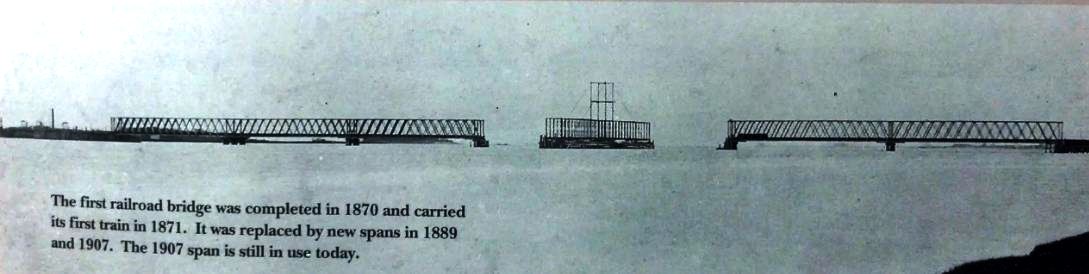
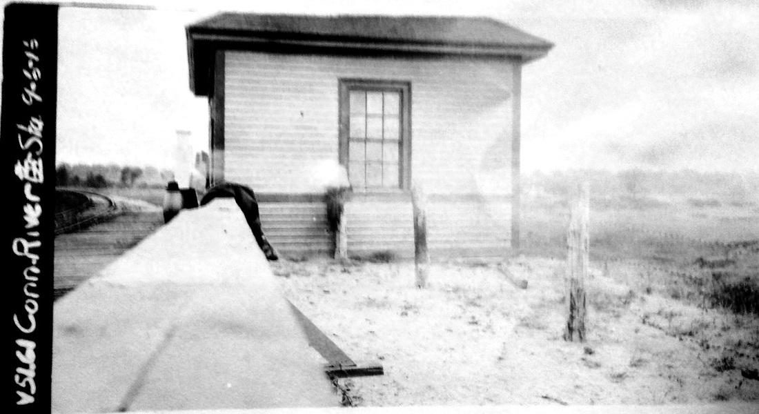
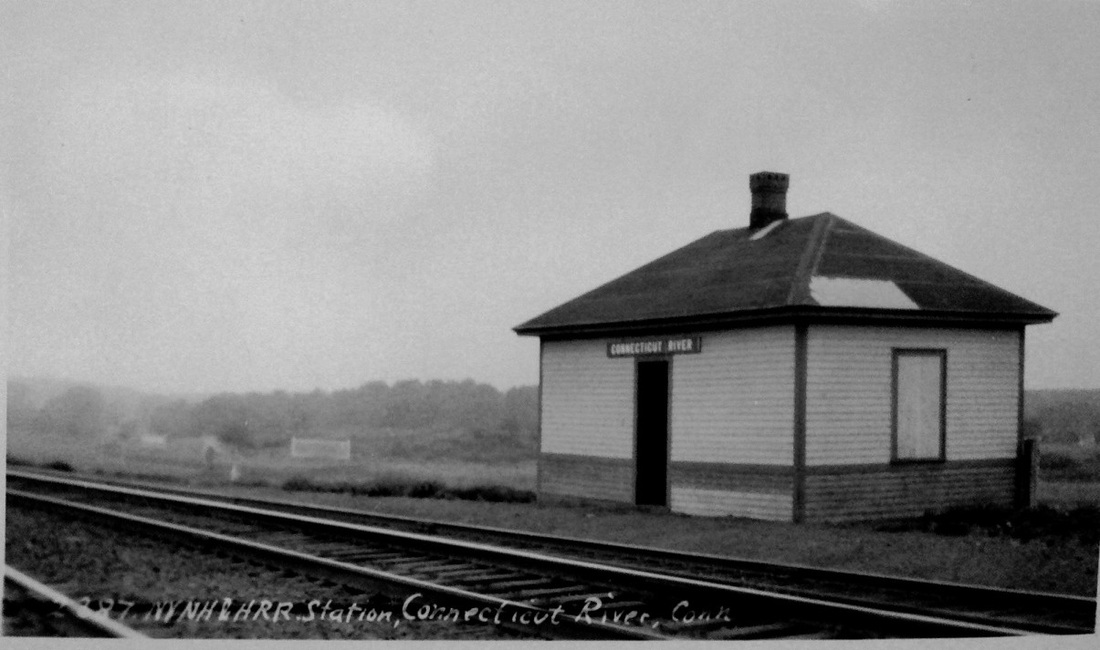
CONNECTICUT RIVER2 [NYNH&H, 1887]
The 9/6/1916 val photo station at [1] is presumably the one built in 1887, as reported by the railroad commissioners. The shot at [2] is Lewis H. Benton #2387 taken in June, 1929, likely on the 23rd. The depot's location is seen in the 1915 val map at [5] where it sits north of the the new ROW to the 1907 bridge. In their report for that year, the commissioners say that "on May 6, 1907, the New York, New Haven & Hartford Railroad Company, having established a new station on the changed location of the Shore Line Division of its railroad at Connecticut River, in the town of Old Saybrook, we authorized the abandonment of the station on the old location." Since this language has been proven elsewhere to mean abandoning the location and not necessarily the building, we infer a slight move of the 1887 structure rather than the building of a new depot. The 1934 aerial map at [5] shows a train, with a smoke plume drifting northward, approaching this station. We assume it not is stopping as our 12/2/1923PTT already does not list CONNECTICUT RIVER and neither do any subsequent timetables we have seen. The shot at [3] looks east and shows tracks still leading to the 1889 bridge north of the larger 1907 structure, which appears to be under construction. It is still in use in 2018. [REFS: CRC35.1887.17; RRC38.26 (5/6/1907)][rev022413, 111518]
The 9/6/1916 val photo station at [1] is presumably the one built in 1887, as reported by the railroad commissioners. The shot at [2] is Lewis H. Benton #2387 taken in June, 1929, likely on the 23rd. The depot's location is seen in the 1915 val map at [5] where it sits north of the the new ROW to the 1907 bridge. In their report for that year, the commissioners say that "on May 6, 1907, the New York, New Haven & Hartford Railroad Company, having established a new station on the changed location of the Shore Line Division of its railroad at Connecticut River, in the town of Old Saybrook, we authorized the abandonment of the station on the old location." Since this language has been proven elsewhere to mean abandoning the location and not necessarily the building, we infer a slight move of the 1887 structure rather than the building of a new depot. The 1934 aerial map at [5] shows a train, with a smoke plume drifting northward, approaching this station. We assume it not is stopping as our 12/2/1923PTT already does not list CONNECTICUT RIVER and neither do any subsequent timetables we have seen. The shot at [3] looks east and shows tracks still leading to the 1889 bridge north of the larger 1907 structure, which appears to be under construction. It is still in use in 2018. [REFS: CRC35.1887.17; RRC38.26 (5/6/1907)][rev022413, 111518]

|

|
|
COOKS [HP&F, c1872]
This stop was in the town of Plainville just before the border with New Britain, about two miles east of the former and three miles west of the latter. It seems to have been named such for Cooks Gap, the break in the trap rock vein that runs north and south through central Connecticut. This stop reportedly first appears on timetables in 1872. A letter written to the railroad commissioners on 11/23/1882 says that "Charles Brooks, fireman, while leaning out of cab window, was struck by car on siding at Cooks Station, and was somewhat injured; although not seriously." In late 1892 a derailment here caused several hours of delay, one of its victims being the NY&NE's crack new Long Island & Eastern States Express westbound to Oyster Bay and Brooklyn, NY. Although the commissioners include this stop in a list of "Principal railway stations in Connecticut" in their 1883 annual report, placing it 11.7 miles from Hartford, little is known about its use for passenger service and we have no photo of what structure, if any, stood at this location. The 1915 val map snippet at [1] is unhelpfully inverted with north at the bottom, thereby putting east to the left. It does show the siding crossing the highway into the Connecticut Quarries Co. The blue pin on the 1966 topo map at [2] shows where the siding leaves the main line, as it still does today to go across Rte 372. The snippet at [3] is from our Track 11 Google Earth map and shows the trackage still in place. The stone business here likely kept the siding filled with cars. The quarry operation became part of the Blakeslee family's New Haven Trap Rock conglomerate and still exists today as a Tilcon property, the major part of which here lies south of I-84. [REFS: CRC30.1883.62; C306][rev110320]
This stop was in the town of Plainville just before the border with New Britain, about two miles east of the former and three miles west of the latter. It seems to have been named such for Cooks Gap, the break in the trap rock vein that runs north and south through central Connecticut. This stop reportedly first appears on timetables in 1872. A letter written to the railroad commissioners on 11/23/1882 says that "Charles Brooks, fireman, while leaning out of cab window, was struck by car on siding at Cooks Station, and was somewhat injured; although not seriously." In late 1892 a derailment here caused several hours of delay, one of its victims being the NY&NE's crack new Long Island & Eastern States Express westbound to Oyster Bay and Brooklyn, NY. Although the commissioners include this stop in a list of "Principal railway stations in Connecticut" in their 1883 annual report, placing it 11.7 miles from Hartford, little is known about its use for passenger service and we have no photo of what structure, if any, stood at this location. The 1915 val map snippet at [1] is unhelpfully inverted with north at the bottom, thereby putting east to the left. It does show the siding crossing the highway into the Connecticut Quarries Co. The blue pin on the 1966 topo map at [2] shows where the siding leaves the main line, as it still does today to go across Rte 372. The snippet at [3] is from our Track 11 Google Earth map and shows the trackage still in place. The stone business here likely kept the siding filled with cars. The quarry operation became part of the Blakeslee family's New Haven Trap Rock conglomerate and still exists today as a Tilcon property, the major part of which here lies south of I-84. [REFS: CRC30.1883.62; C306][rev110320]
Dave Peters Collection
|

|
COOPER [D&N/HRR, c1885]
Cornwall says that this was a flag stop in RIDGEFIELD for all trains but does not say when it was established. The first mention we find is in the 1885 GHD. It is unclear whether it preexisted as a non-timetable stop or it was a late addition by the D&N or an early one by the HRR on whose 12/2/1889 passenger fare schedule it first appears. It, like FLORIDA, is never shown on the RRMs. Train service was discontinued on this branch in 1925 and replaced with New England Transportation buses that may have stopped here. [REFS: 1885GHD; NH1907, 1911, 1923TT; SL17.4.28]
Cornwall says that this was a flag stop in RIDGEFIELD for all trains but does not say when it was established. The first mention we find is in the 1885 GHD. It is unclear whether it preexisted as a non-timetable stop or it was a late addition by the D&N or an early one by the HRR on whose 12/2/1889 passenger fare schedule it first appears. It, like FLORIDA, is never shown on the RRMs. Train service was discontinued on this branch in 1925 and replaced with New England Transportation buses that may have stopped here. [REFS: 1885GHD; NH1907, 1911, 1923TT; SL17.4.28]
|

|
|
|

|

|
|
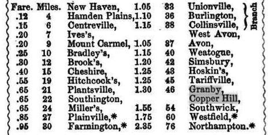
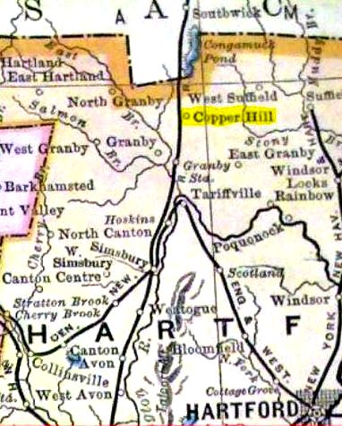
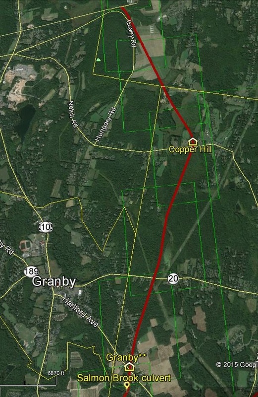
COPPER HILL [NH&N, 1854]
This was a little-known flag stop in the town of Granby for passengers on the Canal line that opened through here in 1854. The first and only real mention of a structure comes in 1855 with an ad for a farm known as the "... Viets Tavern Stand, opposite the Old New Gate Prison and Copper Mine, in East Granby... pleasantly situated... 1 mile from Copper Hill depot..." The mine, worked since 1706 had morphed into a prison during the Revolutionary War until the jail was moved to Wethersfield in 1827. With the property reportedly in litigation thereafter, it was not until 1872 that a reopening of the mine was spoken of and a post office debuted as well, industry and mail both served by the railroad. We have no image of the station here and only only travel guide listings for this stop. Newspapers, however, referred to the location in an 1884 accident which derailed the locomotive and three cars. The 1857 Green's Register at [1] appears to have it listed as a separate stop above GRANBY. The 1869 map at [2] shows the GRANBY station at the red arrow, the location of the COPPER HILL stop at the blue arrow, and the old mine property at the purple arrow. The 1888RAM map [4] indicates the location, though it is not shown as a railroad station, but it is listed as one of two stations in the town of Granby until at least 1899, when more copper closer to the railroad was discovered and a spur to the site was spoken of. The ad in the 1895 inaugural issue of Connecticut Magazine [5] says Canal line trains will be stopping here in season and touts the tourism potential for visitors coming to the old prison. The 1915 val map at [6] shows nothing at Copper Hill Rd. by that time but that the NH&N came to something of a fork here, which is more obvious on our Track 11 Google Earth map snippet at [7]. Ultimately it took the northwesterly route purchased in 1853 by Joseph Sheffield's Farmington Valley R.R., as seen in the val map property listings at [3]. The 1849 ROW to the northeast may well have led to Springfield as the H&NH had feared and engendered the controversy that delayed the opening of the Canal line to Westfield in 1854. [REFS: HDC/01/29/1872/02; WH/02/02/1872/02; NA/02/07/1872/04; NHER/01/30/1884/01; HDC/02/02/1884/04; RAM1893; NHER/09/29/1899/02; HWT/10/02/1899/07; CWN/11/09/1899/10; RAM1899][rev011915]
This was a little-known flag stop in the town of Granby for passengers on the Canal line that opened through here in 1854. The first and only real mention of a structure comes in 1855 with an ad for a farm known as the "... Viets Tavern Stand, opposite the Old New Gate Prison and Copper Mine, in East Granby... pleasantly situated... 1 mile from Copper Hill depot..." The mine, worked since 1706 had morphed into a prison during the Revolutionary War until the jail was moved to Wethersfield in 1827. With the property reportedly in litigation thereafter, it was not until 1872 that a reopening of the mine was spoken of and a post office debuted as well, industry and mail both served by the railroad. We have no image of the station here and only only travel guide listings for this stop. Newspapers, however, referred to the location in an 1884 accident which derailed the locomotive and three cars. The 1857 Green's Register at [1] appears to have it listed as a separate stop above GRANBY. The 1869 map at [2] shows the GRANBY station at the red arrow, the location of the COPPER HILL stop at the blue arrow, and the old mine property at the purple arrow. The 1888RAM map [4] indicates the location, though it is not shown as a railroad station, but it is listed as one of two stations in the town of Granby until at least 1899, when more copper closer to the railroad was discovered and a spur to the site was spoken of. The ad in the 1895 inaugural issue of Connecticut Magazine [5] says Canal line trains will be stopping here in season and touts the tourism potential for visitors coming to the old prison. The 1915 val map at [6] shows nothing at Copper Hill Rd. by that time but that the NH&N came to something of a fork here, which is more obvious on our Track 11 Google Earth map snippet at [7]. Ultimately it took the northwesterly route purchased in 1853 by Joseph Sheffield's Farmington Valley R.R., as seen in the val map property listings at [3]. The 1849 ROW to the northeast may well have led to Springfield as the H&NH had feared and engendered the controversy that delayed the opening of the Canal line to Westfield in 1854. [REFS: HDC/01/29/1872/02; WH/02/02/1872/02; NA/02/07/1872/04; NHER/01/30/1884/01; HDC/02/02/1884/04; RAM1893; NHER/09/29/1899/02; HWT/10/02/1899/07; CWN/11/09/1899/10; RAM1899][rev011915]

|
|
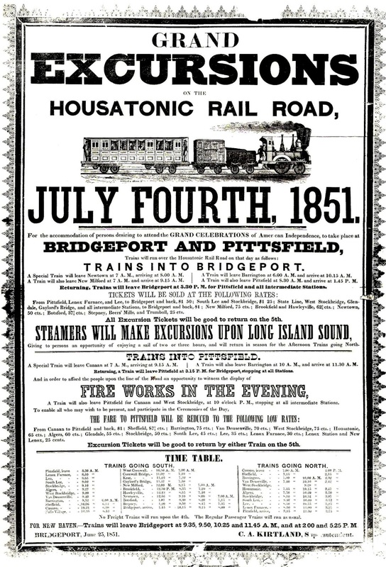
CORNWALL BRIDGE1 [HRR, c1842]
The station in the town of Cornwall takes its name from the bridge crossing the Housatonic River. The first depot is seen on the 1854LC map and the listing is found on the 1851 broadside. There is an 1847 newspaper reference to a first depot when it was said that a branch to Litchfield was being considered from this station at that time. Based on this, we assume that there was a CORNWALL BRIDGE1 from when the HRR completed its track to the Massachusetts state line in 1842. [REFS: RF/05/18/1847/01]
The station in the town of Cornwall takes its name from the bridge crossing the Housatonic River. The first depot is seen on the 1854LC map and the listing is found on the 1851 broadside. There is an 1847 newspaper reference to a first depot when it was said that a branch to Litchfield was being considered from this station at that time. Based on this, we assume that there was a CORNWALL BRIDGE1 from when the HRR completed its track to the Massachusetts state line in 1842. [REFS: RF/05/18/1847/01]
Connecticut Historical Society
|
|
National Archives
|
|
Max Miller Collection
|
Bob Gambling photo
|
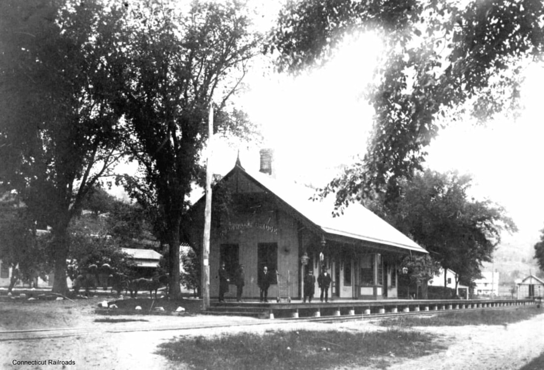
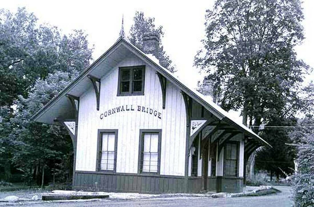
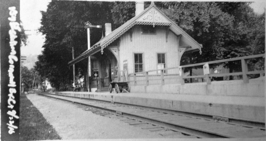
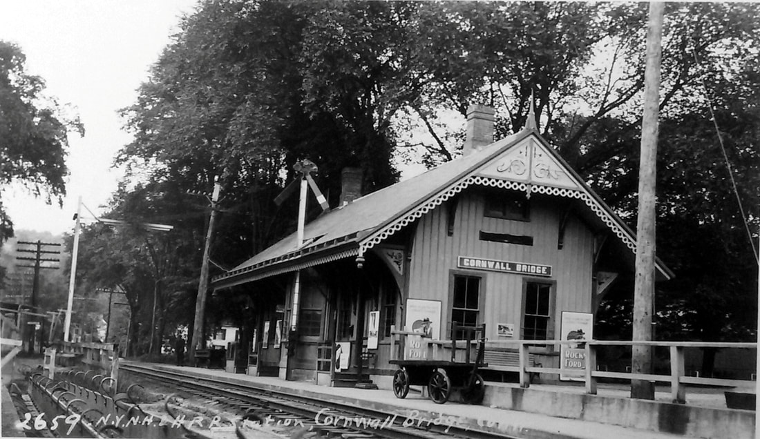
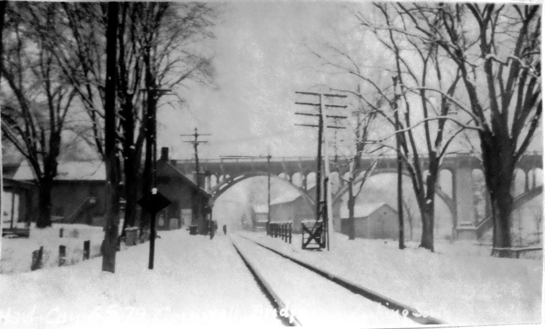
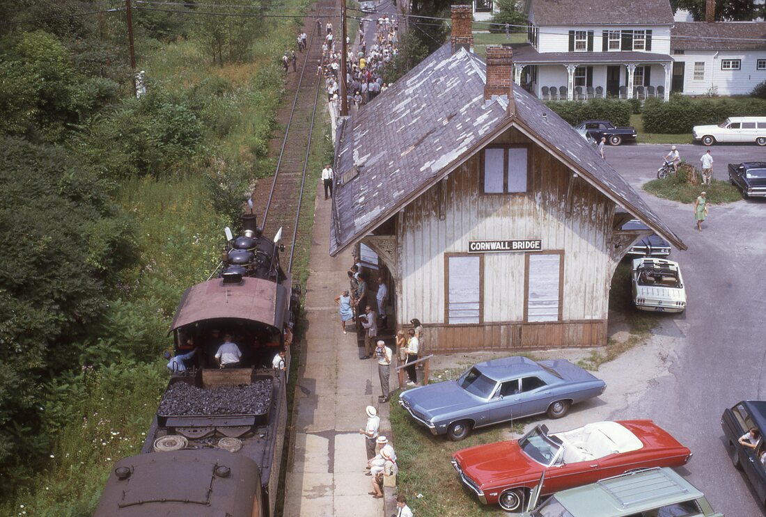
CORNWALL BRIDGE2 [HRR, 1884]
The Connecticut Western News said in April, 1873 that the HRR would "soon erect a new depot" here and that they had bought a large tract of land near the first station to put in new side tracks and "make other improvements to keep pace with the increasing business of the station." The Courant also said at the time that a new structure was in the offing, but it was not until 1884 that the News said a new depot, under contractor Charles Beers of Bridgeport, was "progressing finely and what an ornament and convenience it will be to the many passengers who patronize the road from this station." The depot still stands today on the east side of the track and just north of the beautiful concrete arch highway bridge, of which the newspaper said "... will be not only the longest concrete arch bridge in Connecticut but [also] the largest all concrete grade crossing elimination project in New England" when it opened late in 1931. The shot at [1] looks southeasterly and may date to the 1880s. The view at [2] highlights the HRR's signature Victorian style and embellishments: tall gable roof, curved station lettering, finials, ornate brackets and overhanging eaves; the peak gingerbread and and the ornamental eave trim seen in other photos is absent. Note that the agent's bay is on the street side, not the track side, a detail verified by the 1915 val map at [7]; it makes us think that the track was realigned at some point though the map shows no evidence of that. The north-looking val photo at [3] is dated 9/22/1916. Lewis H. Benton took a similar shot [4], his no. 2569, in June, 1930. The south-looking shot at [5] was taken by the PUC some time after the concrete bridge was completed in 1931 and we can see the depot up ahead on the left. Some time between our 10/8/1962 and 4/30/1967 timetables a changeover to buses took place and trains ceased stopping here. Bob Gambling rode the steam-diesel fan trip that ran from Grand Central Terminal to Canaan on Sunday 8/4/1968 in conjunction with the Old Railroad Days celebration in that town. He took the northward-looking photo at [6] from the bridge showing CVRA no. 97. The station roof is also showing its age and the Penn Central takeover on 1/1/1969 would put an end to these trips. Service on the old HRR would continue under PC until 5/1/1971 but this was not a stop. The March, 1990 NHRHTA newsletter included a real estate ad that said "A circa 1883 Railroad Station tastefully renovated into a fine 3 bedroom residence. This unique property has been unspoiled by time and features mellowed antique moldings and woodwork throughout. Scenic Housatonic River views. This rare Cornwall offering is perfect for those who want the charm of bygone days when quality was not an option." The price at the time was $224,000. [REFS: CWN/04/11/1873/02; HDC/04/15/1873/04; CWN/05/14/1884/02; HC/02/06/1930/06; SAD/02/06/1930/07; SAD/02/08/1932/04; HC/04/23/1972/44A1; NL18.2.4; R43; Trains, July, 1968][rev031319]
The Connecticut Western News said in April, 1873 that the HRR would "soon erect a new depot" here and that they had bought a large tract of land near the first station to put in new side tracks and "make other improvements to keep pace with the increasing business of the station." The Courant also said at the time that a new structure was in the offing, but it was not until 1884 that the News said a new depot, under contractor Charles Beers of Bridgeport, was "progressing finely and what an ornament and convenience it will be to the many passengers who patronize the road from this station." The depot still stands today on the east side of the track and just north of the beautiful concrete arch highway bridge, of which the newspaper said "... will be not only the longest concrete arch bridge in Connecticut but [also] the largest all concrete grade crossing elimination project in New England" when it opened late in 1931. The shot at [1] looks southeasterly and may date to the 1880s. The view at [2] highlights the HRR's signature Victorian style and embellishments: tall gable roof, curved station lettering, finials, ornate brackets and overhanging eaves; the peak gingerbread and and the ornamental eave trim seen in other photos is absent. Note that the agent's bay is on the street side, not the track side, a detail verified by the 1915 val map at [7]; it makes us think that the track was realigned at some point though the map shows no evidence of that. The north-looking val photo at [3] is dated 9/22/1916. Lewis H. Benton took a similar shot [4], his no. 2569, in June, 1930. The south-looking shot at [5] was taken by the PUC some time after the concrete bridge was completed in 1931 and we can see the depot up ahead on the left. Some time between our 10/8/1962 and 4/30/1967 timetables a changeover to buses took place and trains ceased stopping here. Bob Gambling rode the steam-diesel fan trip that ran from Grand Central Terminal to Canaan on Sunday 8/4/1968 in conjunction with the Old Railroad Days celebration in that town. He took the northward-looking photo at [6] from the bridge showing CVRA no. 97. The station roof is also showing its age and the Penn Central takeover on 1/1/1969 would put an end to these trips. Service on the old HRR would continue under PC until 5/1/1971 but this was not a stop. The March, 1990 NHRHTA newsletter included a real estate ad that said "A circa 1883 Railroad Station tastefully renovated into a fine 3 bedroom residence. This unique property has been unspoiled by time and features mellowed antique moldings and woodwork throughout. Scenic Housatonic River views. This rare Cornwall offering is perfect for those who want the charm of bygone days when quality was not an option." The price at the time was $224,000. [REFS: CWN/04/11/1873/02; HDC/04/15/1873/04; CWN/05/14/1884/02; HC/02/06/1930/06; SAD/02/06/1930/07; SAD/02/08/1932/04; HC/04/23/1972/44A1; NL18.2.4; R43; Trains, July, 1968][rev031319]
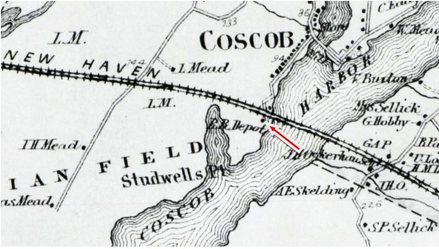
Copyright NHRHTA
COS COB1 [NY&NH, c1852]
This station in the town of GREENWICH was also called COS COB BRIDGE for its location west of the span over its namesake harbor. This stop is not on the 1849TT or the 1851TT, but it is listed in an 1852 newspaper ad showing commutation rates on the NY&NH and Canal lines. The 1868 Beers map shows the location on the south side of the track. We do not have a photo of this first depot, which may have looked like GREENWICH1, NORWALK1, and other early NY&NH cross-gabled structures. [REFS: HDC/07/08/1852/01; CR/07/10/1858/04; GHD1858][rev011713]
This station in the town of GREENWICH was also called COS COB BRIDGE for its location west of the span over its namesake harbor. This stop is not on the 1849TT or the 1851TT, but it is listed in an 1852 newspaper ad showing commutation rates on the NY&NH and Canal lines. The 1868 Beers map shows the location on the south side of the track. We do not have a photo of this first depot, which may have looked like GREENWICH1, NORWALK1, and other early NY&NH cross-gabled structures. [REFS: HDC/07/08/1852/01; CR/07/10/1858/04; GHD1858][rev011713]

Copyright NHRHTA
|
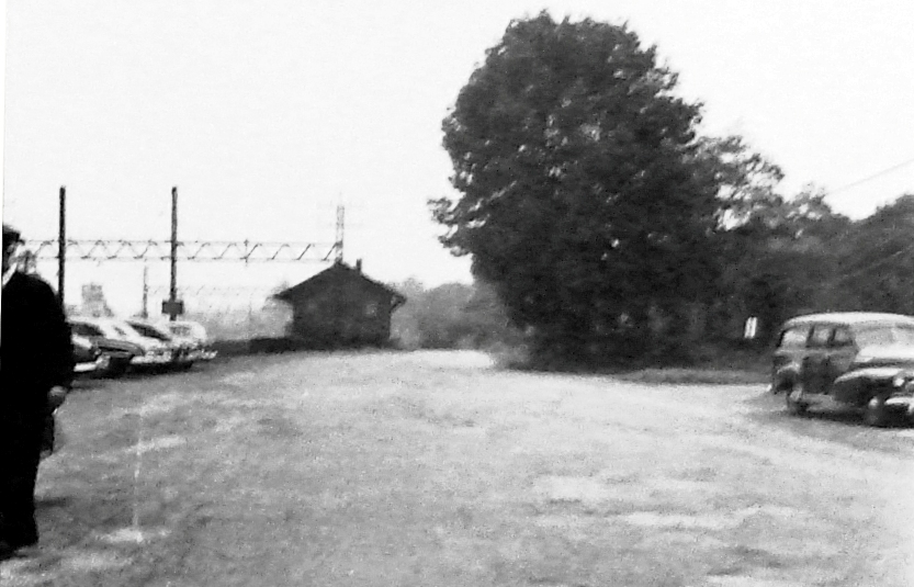
Connecticut Historical Society
|
COS COB2 [NY&NH, 1871]
The Danbury News said in 1871 that the NYNH&H was building a new depot here, this one on the north side of the main line, double-tracked since 1859. What happened to the first structure is not mentioned, but fire caused by sparks from a passing locomotive is the usual suspect. The design and ornate bracket work of COS COB2 makes it look identical to GREENWICH2 built in 1873. The structure, as seen here this westward view, is in use as the freight station and would be torn down in 1955 with the construction of the Connecticut Turnpike that would cross overhead. COS COB3, its replacement, is out of sight behind and to the photographer's right. [REFS: DN/11/15/1871/02; NHER/04/01/1880/01][rev 011713]
The Danbury News said in 1871 that the NYNH&H was building a new depot here, this one on the north side of the main line, double-tracked since 1859. What happened to the first structure is not mentioned, but fire caused by sparks from a passing locomotive is the usual suspect. The design and ornate bracket work of COS COB2 makes it look identical to GREENWICH2 built in 1873. The structure, as seen here this westward view, is in use as the freight station and would be torn down in 1955 with the construction of the Connecticut Turnpike that would cross overhead. COS COB3, its replacement, is out of sight behind and to the photographer's right. [REFS: DN/11/15/1871/02; NHER/04/01/1880/01][rev 011713]
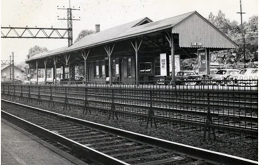
UConn Archives & Special Colls.
|

|
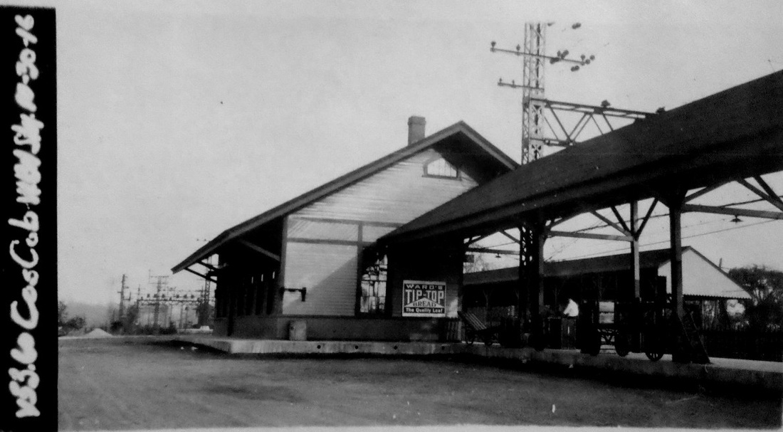
|
COS COB3 [NYNH&H, 1894]
The August, 1954 photo of the westbound station at left is attributed to Charlie Gunn. COS COB2, now the freight house, is in the distance. The 1913 map shows the location of this station on the north side of the tracks. We know from the picture below that COS COB4 was on the other side of the tracks but the map omits it. The Cos Cob power plant is marked on the map by the circle to the right on the edge of the harbor. This saltbox style station was built with the four-tracking of 1894 and received an NRHP designation in 1989. The val photo at right is dated 10/30/1916.
The August, 1954 photo of the westbound station at left is attributed to Charlie Gunn. COS COB2, now the freight house, is in the distance. The 1913 map shows the location of this station on the north side of the tracks. We know from the picture below that COS COB4 was on the other side of the tracks but the map omits it. The Cos Cob power plant is marked on the map by the circle to the right on the edge of the harbor. This saltbox style station was built with the four-tracking of 1894 and received an NRHP designation in 1989. The val photo at right is dated 10/30/1916.
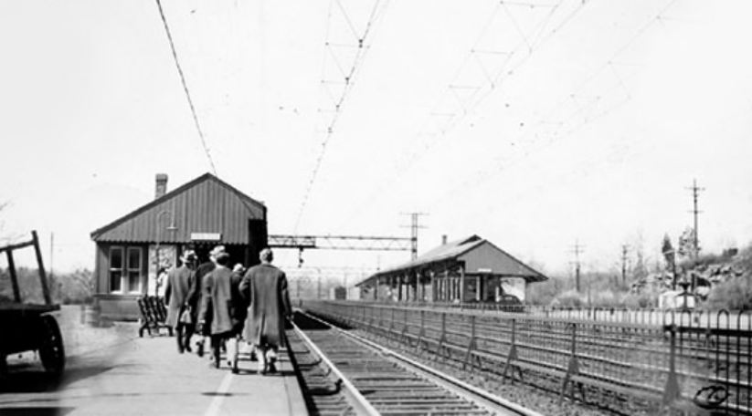
UConn Archives & Special Colls.
|

|
COS COB4 [NYNH&H, 1894]
This was the eastbound station, probably also built ca. 1894 with the four-tracking project. The dimunitive structure is seen at the blue arrow on the 1915 val map at right, with COS COB3 at the red arrow. Smaller facilities on the New Haven-bound side were typical, harking back to the NY&NH that was built primarily to bring people to the Empire State. Most of the early stations were on the north or westbound side of the track from the beginning. In the photo at left dated April 7, 1946, everybody is looking west for the train that will soon take them to points east. [REFS: R44][rev011713]
This was the eastbound station, probably also built ca. 1894 with the four-tracking project. The dimunitive structure is seen at the blue arrow on the 1915 val map at right, with COS COB3 at the red arrow. Smaller facilities on the New Haven-bound side were typical, harking back to the NY&NH that was built primarily to bring people to the Empire State. Most of the early stations were on the north or westbound side of the track from the beginning. In the photo at left dated April 7, 1946, everybody is looking west for the train that will soon take them to points east. [REFS: R44][rev011713]

www.iridetheharlemline.com
COS COB5 [MN, 2000?]
Newer eastbound platform.
Newer eastbound platform.
New Haven Museum
COTTAGE GROVE1 [CW, 1873]
This stop in the town of Bloomfield was not an original one on the CW. The newspaper said in 1873 that this was to be a new station and that the frame was being put up on that very day by the Cottage Grove Co. This investment group hoped to develop the location, four miles from Hartford, as a new residential and manufacturing center and an important suburb of the capital city, akin in many ways to Tyler City, our website namesake covered on Track 1. In addition, the CW did a large excursion business for those wishing to visit the grove for which the area was named. Excluding the cost of repairs needed, the frame structure was in 'good' condition and valued at $450 in the NY&NE's 1880 lease appraisal. Compared to the substantial BLOOMFIELD passenger depot valued at $1500 and the smaller SCOTLAND/NORTH BLOOMFIELD at $250, COTTAGE GROVE1 must have been a medium-sized structure and more than just a small shelter. The blue arrow on the real-estate atlas map shows the location to be east of the track and north of the site of the second station. We have no photo of COTTAGE GROVE1 and we do not know what necessitated its replacement in 1903. [REFS: HDC/06/03/1873/04; HDC/09/17/1873/04][rev010718]
This stop in the town of Bloomfield was not an original one on the CW. The newspaper said in 1873 that this was to be a new station and that the frame was being put up on that very day by the Cottage Grove Co. This investment group hoped to develop the location, four miles from Hartford, as a new residential and manufacturing center and an important suburb of the capital city, akin in many ways to Tyler City, our website namesake covered on Track 1. In addition, the CW did a large excursion business for those wishing to visit the grove for which the area was named. Excluding the cost of repairs needed, the frame structure was in 'good' condition and valued at $450 in the NY&NE's 1880 lease appraisal. Compared to the substantial BLOOMFIELD passenger depot valued at $1500 and the smaller SCOTLAND/NORTH BLOOMFIELD at $250, COTTAGE GROVE1 must have been a medium-sized structure and more than just a small shelter. The blue arrow on the real-estate atlas map shows the location to be east of the track and north of the site of the second station. We have no photo of COTTAGE GROVE1 and we do not know what necessitated its replacement in 1903. [REFS: HDC/06/03/1873/04; HDC/09/17/1873/04][rev010718]
|

|

ICC Collection / National Archives
|
COTTAGE GROVE2 [CNE, 1903]
We do not have a picture of this station. Built in 1903 together with one at NORTH BLOOMFIELD, later called BARNARDS and seen at left, we might infer that they looked the same. Both, in fact, are described as "waiting rooms" in the ICC field notes and have a similar footprint on the val maps, this one shown at right with 'Flag Stop' marked. The structure stands in the southwest quadrant of the farm-road grade crossing. The middle photo is from Nimke, who says it was taken on 10/23/1925, and looks south (railroad east) toward the Tobey Rd. grade crossing. COTTAGE GROVE2 would have stood in the left foreground, perhaps just behind the photographer. [REFS: CRC51.1903.22; HC/11/14/1903/05; SL23.4.7: CNE 1912TT][rev022413]
We do not have a picture of this station. Built in 1903 together with one at NORTH BLOOMFIELD, later called BARNARDS and seen at left, we might infer that they looked the same. Both, in fact, are described as "waiting rooms" in the ICC field notes and have a similar footprint on the val maps, this one shown at right with 'Flag Stop' marked. The structure stands in the southwest quadrant of the farm-road grade crossing. The middle photo is from Nimke, who says it was taken on 10/23/1925, and looks south (railroad east) toward the Tobey Rd. grade crossing. COTTAGE GROVE2 would have stood in the left foreground, perhaps just behind the photographer. [REFS: CRC51.1903.22; HC/11/14/1903/05; SL23.4.7: CNE 1912TT][rev022413]
COUCHS [D&N, c1875]
This was a stop in Ridgefield, according to Cornwall, at MP 14, about a mile above BRANCHVILLE and a mile below SANFORDS. [REFS: SL17.4.25]
This was a stop in Ridgefield, according to Cornwall, at MP 14, about a mile above BRANCHVILLE and a mile below SANFORDS. [REFS: SL17.4.25]
|
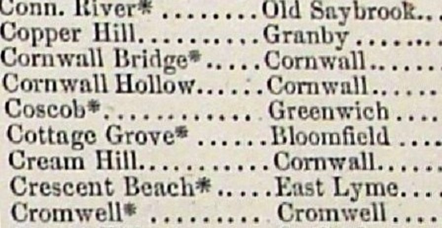
|
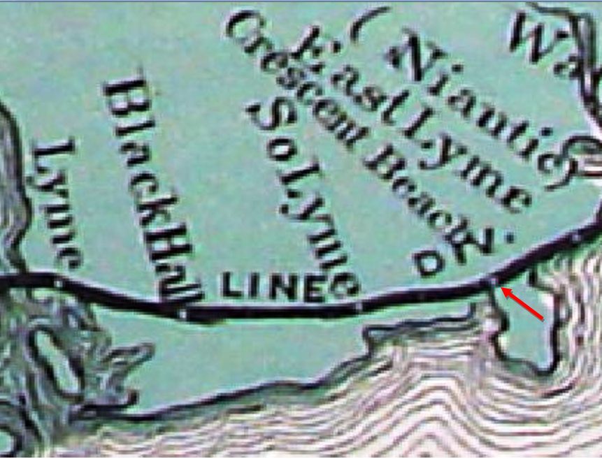
|
CRESCENT BEACH1 [NYNH&H, 1873]
The first reference to this stop in the town of East Lyme is found in the Palladium in March, 1873 which said that "... a new depot is to be erected by the Shore Line railroad company on the land of H. Cruttenden, Crescent Beach, Niantic. In a tourist-oriented ad placed by Mr. C. himself he says that "... The new depot at Crescent Beach will be completed by July 1st." Middletown's Constitution newspaper reported by the end of July that "... a new station has been established on the Shore Line road, called Crescent Beach. It is about a mile west of Niantic (East Lyme)."Our arrow on the 1868 map at [1] shows the future location of the station and the sparsely populated area. The stop is shown in the first GHD gazetteer in 1879 at [2] but, perhaps because of its seasonal status, does not appear on the RRMs (first was in 1876) until 1884, as seen at [3]. A July, 1883 article said that eight daily trains were stopping here at that time. In 1884, we learn from the Register that "The Consolidated road has removed the Crescent Beach (Niantic) depot on the Shore Line division and sold it to the bathers here for a bath house. It has already been removed to the shore for its new patrons. A new and more ornamental station will be erected on its site, one that will be larger and better suited for the patrons of this growing summer resort." We have no photo of this diminutive first station. [REFS: NHDP/03/17/1873/04; HDC/04/28/1873/01; MC/07/30/1873/02; HDC/06/08/1883/02 NHER/07/16/1883/04; NHER/07/31/1883/04; NHER/06/12/1884/01; NHER/06/23/1884/01][add 012422]
The first reference to this stop in the town of East Lyme is found in the Palladium in March, 1873 which said that "... a new depot is to be erected by the Shore Line railroad company on the land of H. Cruttenden, Crescent Beach, Niantic. In a tourist-oriented ad placed by Mr. C. himself he says that "... The new depot at Crescent Beach will be completed by July 1st." Middletown's Constitution newspaper reported by the end of July that "... a new station has been established on the Shore Line road, called Crescent Beach. It is about a mile west of Niantic (East Lyme)."Our arrow on the 1868 map at [1] shows the future location of the station and the sparsely populated area. The stop is shown in the first GHD gazetteer in 1879 at [2] but, perhaps because of its seasonal status, does not appear on the RRMs (first was in 1876) until 1884, as seen at [3]. A July, 1883 article said that eight daily trains were stopping here at that time. In 1884, we learn from the Register that "The Consolidated road has removed the Crescent Beach (Niantic) depot on the Shore Line division and sold it to the bathers here for a bath house. It has already been removed to the shore for its new patrons. A new and more ornamental station will be erected on its site, one that will be larger and better suited for the patrons of this growing summer resort." We have no photo of this diminutive first station. [REFS: NHDP/03/17/1873/04; HDC/04/28/1873/01; MC/07/30/1873/02; HDC/06/08/1883/02 NHER/07/16/1883/04; NHER/07/31/1883/04; NHER/06/12/1884/01; NHER/06/23/1884/01][add 012422]

CRESCENT BEACH2 [NYNH&H, 1887]
Also called CRESCENT BEACH AND BLACK POINT because it served the trackside community as well as the one down at the point of the peninsula. We assume that the image shows the second, the "new and more ornamental station" and not the first station. Per the previous entry, it stood on the same site as the first station, south of the still-single track and east of Black Point Rd. The railroad commissioners said in their 1888 report covering the previous year that ... a flag station has been located at Crescent Beach." A flag stop without a structure? Could it be that, after the removal of CRESCENT BEACH1, this stop was without a depot for the 1884, 1885 and 1886 seasons? A Register article in June, 1886 said that "a new station has been promised by the Consolidated road at Black Point, Niantic, in view of the growth of the place as a summer resort." This growth was due mostly to the efforts to establish a Baptist meeting grounds and there are numerous newspaper articles about the religious community's investment in land sold by Cruttenden, "one of the sharpest and by no means the most liberal of men you will meet." To their dismay, the faithful found that the clever Mr. C. had sold beach rights to others so that the "exclusive right to an exclusive baptistery," i.e. Long Island Sound(!), which was "large enough to baptize all the Baptists in the state, if necessary," was not to be had. In spite of grumblings and rumors of malaria and mosquitos in the "swamp land at Crescent Beach," a tabernacle for religious worship was erected. That building, reportedly looking "... more like a big skating rink than anything else...," was expected to be dedicated by a mass Sunday school meeting on 7/8/1884. Said to have a capacity of 1,500 people, it subsequently became a venue for religious services, temperance conventions, and other gatherings. While appreciated at first, a Courant article in 1891 already had complaints that "something that we have long needed here is a desirable depot. The building at present is but a poor apology for one. There is certainly enough travel to warrant the railroad people to put up a building that will so much cover one from the sun and the rain and nothing more. A meeting of those interested has been held and a committee appointed to confer with the railroad officials." While the reporter's wording is a little convoluted, the residents clearly wanted a more substantial depot for their burgeoning cottage community. The double-tracking of the Shore Line had just been completed in August, 1891 and may have added to the fever, if not the necessity, of changes here. [REFS: NHER/06/14/1886/04; NHER/07/23/1886/02; NHER/04/16/1888/04; HC/04/16/1888/06; CRC36.1888.19; HC/07/21/1891/05; BH/08/25/1891/02; 1871, 1875, 1886, 1894TT][rev022215, 012422]
Also called CRESCENT BEACH AND BLACK POINT because it served the trackside community as well as the one down at the point of the peninsula. We assume that the image shows the second, the "new and more ornamental station" and not the first station. Per the previous entry, it stood on the same site as the first station, south of the still-single track and east of Black Point Rd. The railroad commissioners said in their 1888 report covering the previous year that ... a flag station has been located at Crescent Beach." A flag stop without a structure? Could it be that, after the removal of CRESCENT BEACH1, this stop was without a depot for the 1884, 1885 and 1886 seasons? A Register article in June, 1886 said that "a new station has been promised by the Consolidated road at Black Point, Niantic, in view of the growth of the place as a summer resort." This growth was due mostly to the efforts to establish a Baptist meeting grounds and there are numerous newspaper articles about the religious community's investment in land sold by Cruttenden, "one of the sharpest and by no means the most liberal of men you will meet." To their dismay, the faithful found that the clever Mr. C. had sold beach rights to others so that the "exclusive right to an exclusive baptistery," i.e. Long Island Sound(!), which was "large enough to baptize all the Baptists in the state, if necessary," was not to be had. In spite of grumblings and rumors of malaria and mosquitos in the "swamp land at Crescent Beach," a tabernacle for religious worship was erected. That building, reportedly looking "... more like a big skating rink than anything else...," was expected to be dedicated by a mass Sunday school meeting on 7/8/1884. Said to have a capacity of 1,500 people, it subsequently became a venue for religious services, temperance conventions, and other gatherings. While appreciated at first, a Courant article in 1891 already had complaints that "something that we have long needed here is a desirable depot. The building at present is but a poor apology for one. There is certainly enough travel to warrant the railroad people to put up a building that will so much cover one from the sun and the rain and nothing more. A meeting of those interested has been held and a committee appointed to confer with the railroad officials." While the reporter's wording is a little convoluted, the residents clearly wanted a more substantial depot for their burgeoning cottage community. The double-tracking of the Shore Line had just been completed in August, 1891 and may have added to the fever, if not the necessity, of changes here. [REFS: NHER/06/14/1886/04; NHER/07/23/1886/02; NHER/04/16/1888/04; HC/04/16/1888/06; CRC36.1888.19; HC/07/21/1891/05; BH/08/25/1891/02; 1871, 1875, 1886, 1894TT][rev022215, 012422]
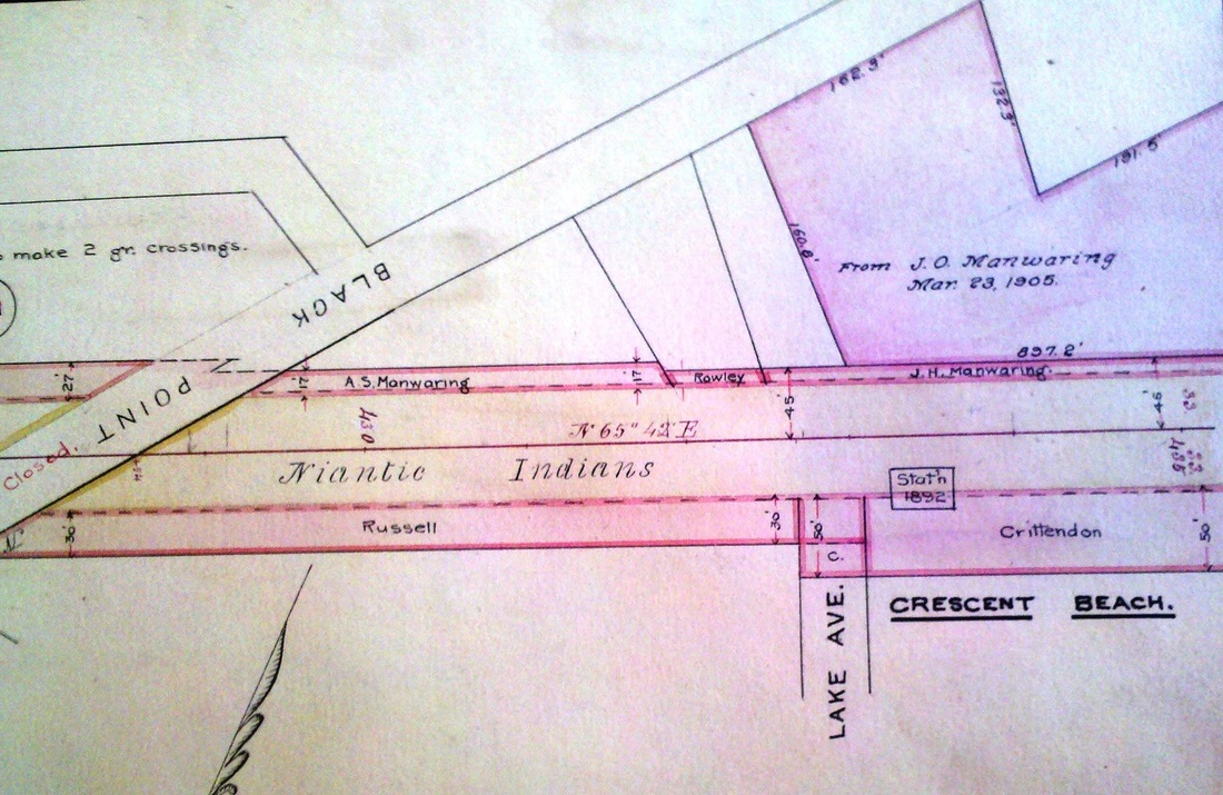
|
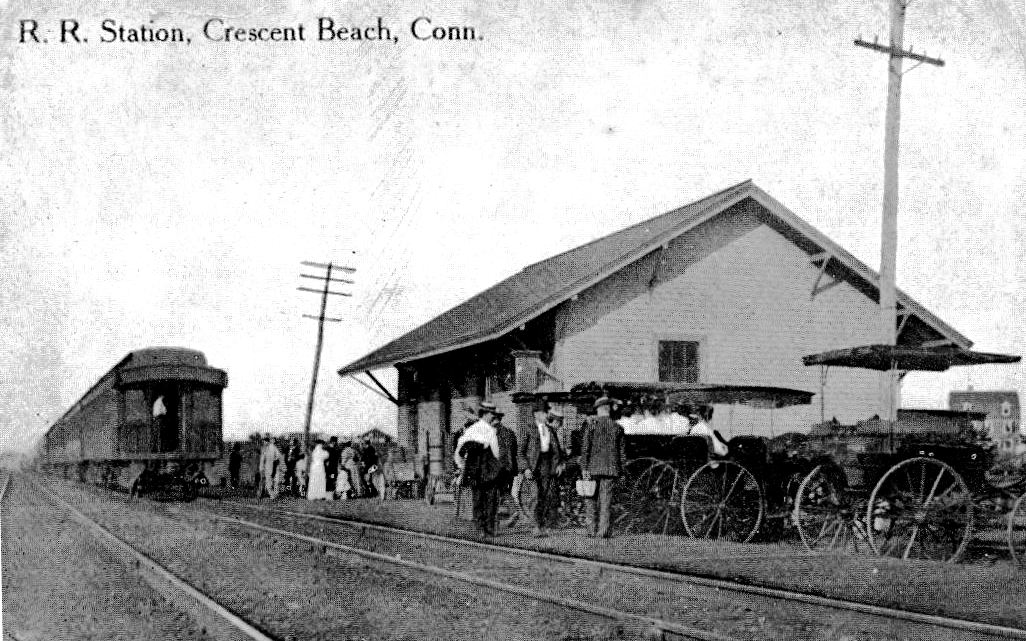
|
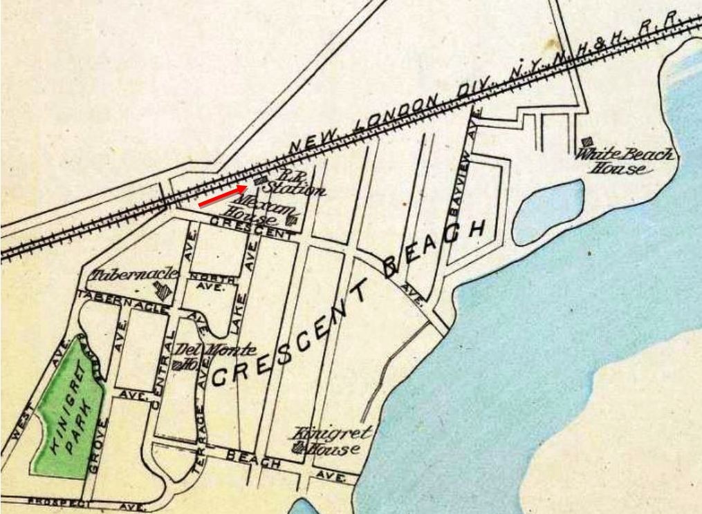
|
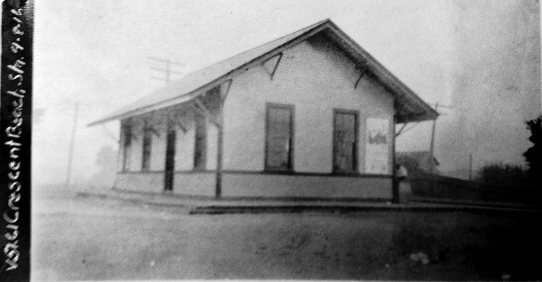
|
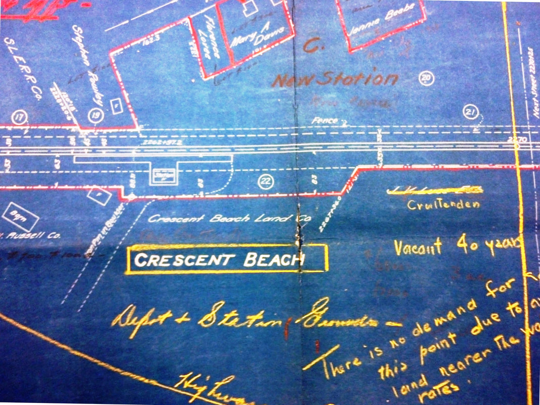
National Archives
|
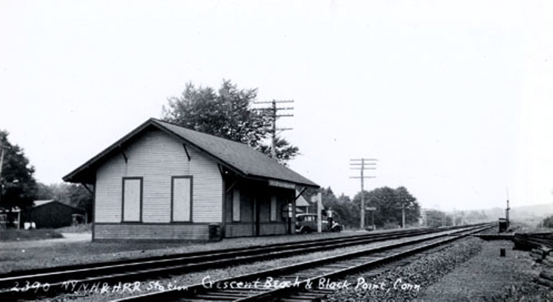
|
CRESCENT BEACH3 [NYNH&H, 1892]
The structure seen here opened on 8/6/1892. The newspaper reported this as "a red letter day in the history of Crescent Beach" with a large and enthusiastic audience at The Tabernacle celebrating "the completion of the beautiful and roomy new railroad station." The real estate map at [1] corroborates the date and shows the land still owned by our old friend Mr. C., here spelled Crittenden. Newspaper articles say that railroad was amenable to building a new station if the land was donated. Previously we assume it was rented. Private interests, villages and municipalities had done so often in the past, e.g. our namesake TYLER CITY, but here seasonal residents were "... busy collecting funds with which to purchase a site on which the Consolidated railroad will erect a depot." The card image at [2] is postmarked 1908 and shows a busy scene looking east at the station which was built on the south side of the newly double-tracked line. The red arrow shows the location on the 1893 Hurd map at [3]. Steamers were also docking down at the shore and bringing day-trippers as well as summer residents. A baseball team, a casino where the Crescent Beach Orchestra played, and regattas sponsored by the yacht club were big draws; a steel pier was even in the offing in 1906. Trolley service from Niantic opened in 1912 and brought yet more people to this popular resort. According to a 1914 timetable, as many as eight weekday and Saturday trains were stopping here, plus two on Sundays, during the summer season from 6/21 to 9/6. The val photo at [4] shows the depot on 9/8/1916. The date of the val map at [5], marked up for real estate purposes, is not known. It is in agreement with the other maps showing the station at the head of Lake St. on property owned now by the Crescent Beach Land Co. Likely a victim of the Great Depression along with SOUND VIEW and other seasonal Shore Line stations, this was a Saturday-only flag stop for one eastbound train by 1932 when the Middletown Press reported that the NYNH&H was to petition on 1/14/1933 to discontinue stopping at the depot, "which has not been used for a number of years and at which only mail has been thrown off once a day during the summer months. The station has been boarded up for some years after about all the windows had been broken. Removal of the station would improve the property and do away with a fire hazard..." Lewis H. Benton's photo #2390 at [6] dates to 6/23/29 and is likely the last image we have of the boarded-up depot. Fellow photographer and the duo's driver Irving N. Drake is seen at center next to his sedan. This station does not appear on the October, 1938 SSRR list making it likely that it was torn down in the aftermath of the infamous September 21st hurricane. The snippet at [7[ from our Track 11 Google Earth map and shows the location today. The association of property owners is still in existence today, owing their origins to the good railroad service of the last two centuries. One relic of Crescent Beach's religious history is found in the street aptly named Tabernacle Ave. [REFS: HC/07/23/1892/03; HC/08/09/1892/03; NHER/05/13/1899/01; NHER/07/17/1900/01; HC/08/29/1906/14; HC/07/26/1912/17; LWTT rev6/29/1914; NLD/11/14/1931/04: depot's toilet door found on beach with a burgled slot machine on it; Form 200TT 2/8/1932; MP/12/12/1932/08; HC/01/14/1933/06; Status of Stations to be Retired and Removed, October, 1938][rev071715; 012422]
The structure seen here opened on 8/6/1892. The newspaper reported this as "a red letter day in the history of Crescent Beach" with a large and enthusiastic audience at The Tabernacle celebrating "the completion of the beautiful and roomy new railroad station." The real estate map at [1] corroborates the date and shows the land still owned by our old friend Mr. C., here spelled Crittenden. Newspaper articles say that railroad was amenable to building a new station if the land was donated. Previously we assume it was rented. Private interests, villages and municipalities had done so often in the past, e.g. our namesake TYLER CITY, but here seasonal residents were "... busy collecting funds with which to purchase a site on which the Consolidated railroad will erect a depot." The card image at [2] is postmarked 1908 and shows a busy scene looking east at the station which was built on the south side of the newly double-tracked line. The red arrow shows the location on the 1893 Hurd map at [3]. Steamers were also docking down at the shore and bringing day-trippers as well as summer residents. A baseball team, a casino where the Crescent Beach Orchestra played, and regattas sponsored by the yacht club were big draws; a steel pier was even in the offing in 1906. Trolley service from Niantic opened in 1912 and brought yet more people to this popular resort. According to a 1914 timetable, as many as eight weekday and Saturday trains were stopping here, plus two on Sundays, during the summer season from 6/21 to 9/6. The val photo at [4] shows the depot on 9/8/1916. The date of the val map at [5], marked up for real estate purposes, is not known. It is in agreement with the other maps showing the station at the head of Lake St. on property owned now by the Crescent Beach Land Co. Likely a victim of the Great Depression along with SOUND VIEW and other seasonal Shore Line stations, this was a Saturday-only flag stop for one eastbound train by 1932 when the Middletown Press reported that the NYNH&H was to petition on 1/14/1933 to discontinue stopping at the depot, "which has not been used for a number of years and at which only mail has been thrown off once a day during the summer months. The station has been boarded up for some years after about all the windows had been broken. Removal of the station would improve the property and do away with a fire hazard..." Lewis H. Benton's photo #2390 at [6] dates to 6/23/29 and is likely the last image we have of the boarded-up depot. Fellow photographer and the duo's driver Irving N. Drake is seen at center next to his sedan. This station does not appear on the October, 1938 SSRR list making it likely that it was torn down in the aftermath of the infamous September 21st hurricane. The snippet at [7[ from our Track 11 Google Earth map and shows the location today. The association of property owners is still in existence today, owing their origins to the good railroad service of the last two centuries. One relic of Crescent Beach's religious history is found in the street aptly named Tabernacle Ave. [REFS: HC/07/23/1892/03; HC/08/09/1892/03; NHER/05/13/1899/01; NHER/07/17/1900/01; HC/08/29/1906/14; HC/07/26/1912/17; LWTT rev6/29/1914; NLD/11/14/1931/04: depot's toilet door found on beach with a burgled slot machine on it; Form 200TT 2/8/1932; MP/12/12/1932/08; HC/01/14/1933/06; Status of Stations to be Retired and Removed, October, 1938][rev071715; 012422]
|

|
|
|
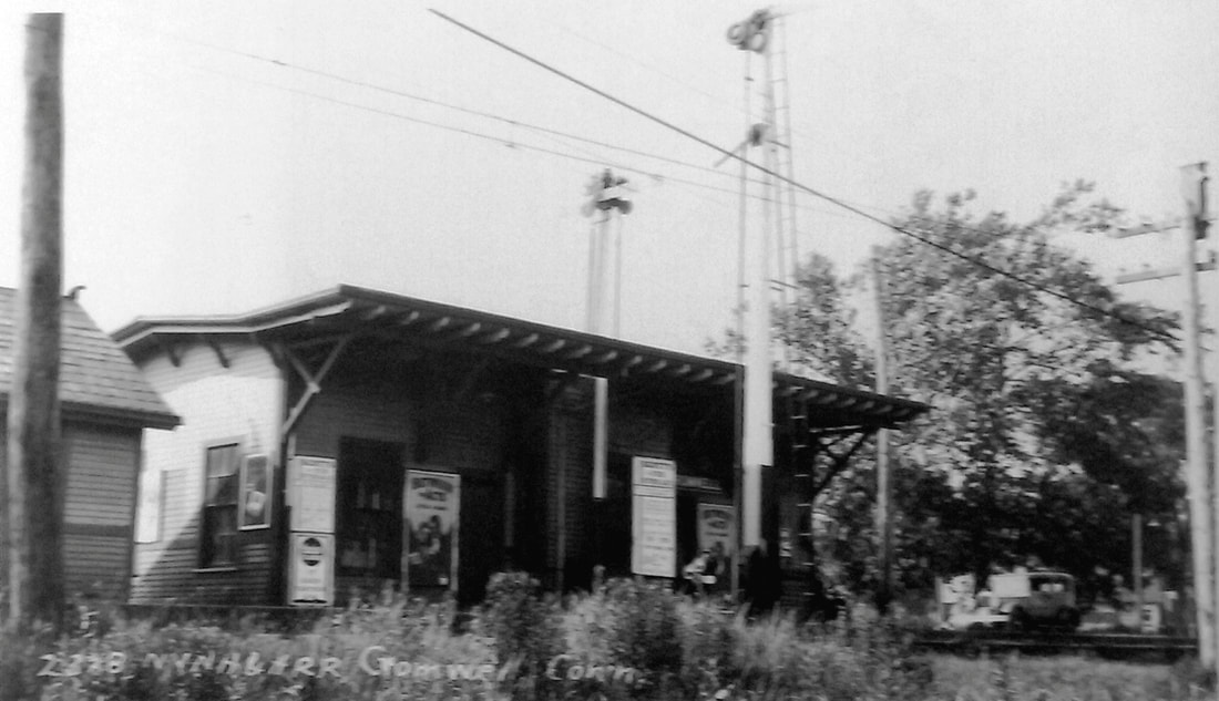
|
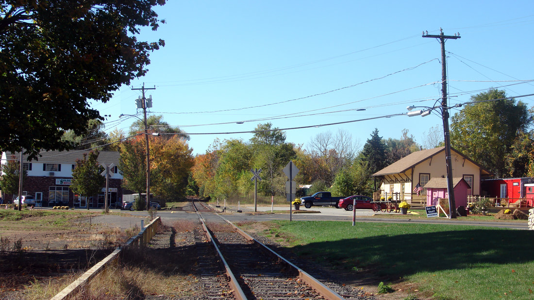
|
CROMWELL/V [CV, 1871]
This station was an original stop on the CV which opened in 1871. It is seen on 6/17/1915 in the ICC valuation photo at [1] in its relocated position to the south. The original location is shown by the red arrow on the 1874 Beers map at [2]. The railroad commissioners reported in 1890 that this station was abandoned, meaning in this case that the location on Wall St. was surrendered and the station was moved. Other sources corroborate that it was relocated 600 feet to the south, just below the railroad's diagonal crossing of what is Rte. 99 today. The commissioners also noted the "erection of a new depot building," which must have been the freight structure seen in the distance at [1]. This was a common practice when business grew to a point where convenience and safety dictated separate facilities for passengers. We have highlighted the station in yellow on the 6/30/1915 val map at [3]. The Hartford-Middletown interurban opened in 1909, leaving the CV tracks from Middletown and swinging onto its own right of way on Rte. 99. This is seen as the heavy dashed line on the val map. The image at [4] shows a locomotive shoving cars south toward the station and freight house beyond, likely in the 1920s. A net of trolley wire is strung overhead as the interurban line curbs to the north. Seen at [5] is Lewis H. Benton's photo no. 2378 taken in June, 1929 when working his way north on the line. His transportation, Irving Drake's car, is visible at right; Fellow photographer Drake, typically mugging it up for the camera, is nowhere to be seen. The 3/15/1939 addendum to SSRR list says the agent was being transferred to the freight house after 5/1 and the 7/19/1940 update says it was sold on 2/14/1940. According to Max Miller with a slight variance in the date of 2/9/1940, it was sold to Monnes Dairy Farm and dismantled, the wood being used to construct a tool shed. Today the view south shows only the extant freight station which was set back from the track by real-estate business owners Glen and Beth Johnson. It is flanked by a caboose and period freight cars on a special siding that was put in by A.J. Belliveau, owner of the current Central New England RR which he reincarnated; see our entry at GRIFFINS. When the MW&CR Ghost Tour took the couple up on their offer for us to stop there on 4/9/2017, it was old home week for A.J, Bill Sample, Max Miller and others aboard. A lot of history was relived and created on that special day! The snippet from our Track 11 Google Earth maps shows the layout here today. The trolley line is orange. Also noted is the fact that this station served as SS F-282 to protect the traffic interchange. [REFS: CRC38.1890.39; RRC14.118 (5/20/1890); ATVL, p19][rev010518, 062822]
This station was an original stop on the CV which opened in 1871. It is seen on 6/17/1915 in the ICC valuation photo at [1] in its relocated position to the south. The original location is shown by the red arrow on the 1874 Beers map at [2]. The railroad commissioners reported in 1890 that this station was abandoned, meaning in this case that the location on Wall St. was surrendered and the station was moved. Other sources corroborate that it was relocated 600 feet to the south, just below the railroad's diagonal crossing of what is Rte. 99 today. The commissioners also noted the "erection of a new depot building," which must have been the freight structure seen in the distance at [1]. This was a common practice when business grew to a point where convenience and safety dictated separate facilities for passengers. We have highlighted the station in yellow on the 6/30/1915 val map at [3]. The Hartford-Middletown interurban opened in 1909, leaving the CV tracks from Middletown and swinging onto its own right of way on Rte. 99. This is seen as the heavy dashed line on the val map. The image at [4] shows a locomotive shoving cars south toward the station and freight house beyond, likely in the 1920s. A net of trolley wire is strung overhead as the interurban line curbs to the north. Seen at [5] is Lewis H. Benton's photo no. 2378 taken in June, 1929 when working his way north on the line. His transportation, Irving Drake's car, is visible at right; Fellow photographer Drake, typically mugging it up for the camera, is nowhere to be seen. The 3/15/1939 addendum to SSRR list says the agent was being transferred to the freight house after 5/1 and the 7/19/1940 update says it was sold on 2/14/1940. According to Max Miller with a slight variance in the date of 2/9/1940, it was sold to Monnes Dairy Farm and dismantled, the wood being used to construct a tool shed. Today the view south shows only the extant freight station which was set back from the track by real-estate business owners Glen and Beth Johnson. It is flanked by a caboose and period freight cars on a special siding that was put in by A.J. Belliveau, owner of the current Central New England RR which he reincarnated; see our entry at GRIFFINS. When the MW&CR Ghost Tour took the couple up on their offer for us to stop there on 4/9/2017, it was old home week for A.J, Bill Sample, Max Miller and others aboard. A lot of history was relived and created on that special day! The snippet from our Track 11 Google Earth maps shows the layout here today. The trolley line is orange. Also noted is the fact that this station served as SS F-282 to protect the traffic interchange. [REFS: CRC38.1890.39; RRC14.118 (5/20/1890); ATVL, p19][rev010518, 062822]
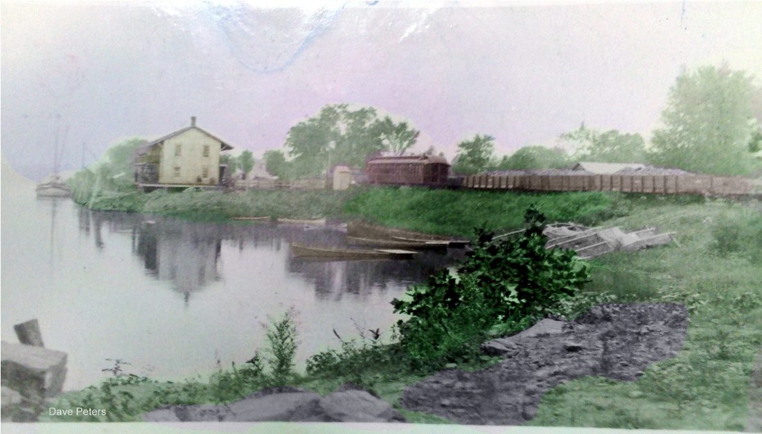
|

|
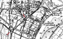
|
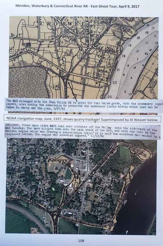
|
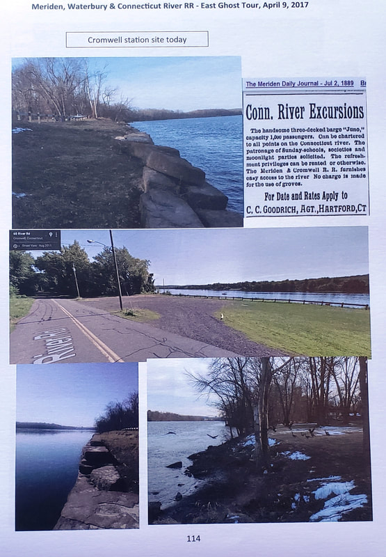
|
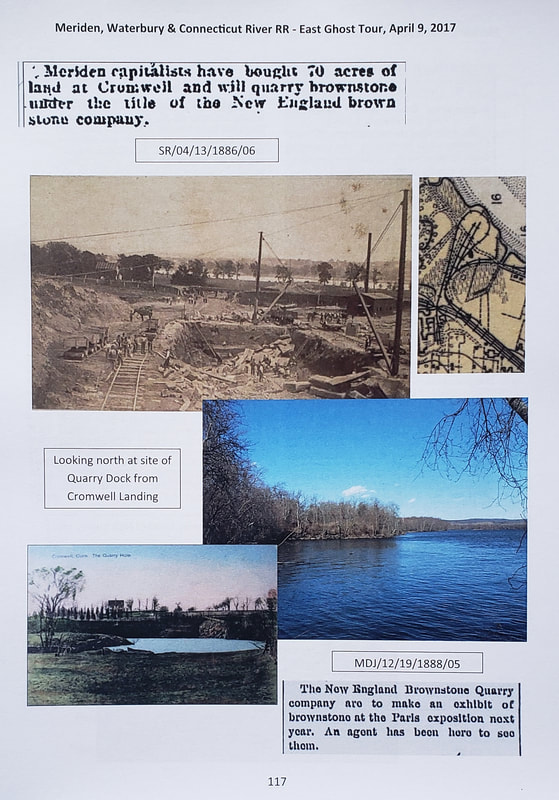
|
|
CROMWELL/M [M&C, 1885]
This was the 1885 station on the Meriden & Cromwell RR at the Connecticut River terminus. The M&C crossed under the CV just south of the CV station and hooked around to the river landing where brownstone was quarried, boats were built, coal was received, and vessels docked for river cruises to exotic locations to the south. The little railroad that couldn't do it, did it, until captured by the New Haven through surrogates. The Westfield-Cromwell portion of the line was out of service as of 1899 and the track removed in 1903, then sending traffic from WESTFIELD to MIDDLETOWN on the newly created Middletown, Meriden & Waterbury RR. We do not know the fate of this depot. The view at [1], colorized by Al Weaver to bring out details, looks south at the depot in an idyllic setting beyond the cove. The shot at [2] shows an M&C combination car taking passengers behind one of the road's first locomotives; we cannot see the number but shot must date from 1885 to 1888 when the M&C became the Meriden, Waterbury & Connecticut River RR after its extension to the Brass city in the latter year. The 1900 NOAA map at [3] shows the CROMWELL/V station at the upper arrow and the M&C undercrossing at the lower arrow. Our MW&CR Ghost Train Tour reached here on 4/9/2017 and the grounds and extant vestiges were examined. We have reproduced the relevant pages at [4] - [7]. They should be self-explanatory with the captions. [rev 062822]
This was the 1885 station on the Meriden & Cromwell RR at the Connecticut River terminus. The M&C crossed under the CV just south of the CV station and hooked around to the river landing where brownstone was quarried, boats were built, coal was received, and vessels docked for river cruises to exotic locations to the south. The little railroad that couldn't do it, did it, until captured by the New Haven through surrogates. The Westfield-Cromwell portion of the line was out of service as of 1899 and the track removed in 1903, then sending traffic from WESTFIELD to MIDDLETOWN on the newly created Middletown, Meriden & Waterbury RR. We do not know the fate of this depot. The view at [1], colorized by Al Weaver to bring out details, looks south at the depot in an idyllic setting beyond the cove. The shot at [2] shows an M&C combination car taking passengers behind one of the road's first locomotives; we cannot see the number but shot must date from 1885 to 1888 when the M&C became the Meriden, Waterbury & Connecticut River RR after its extension to the Brass city in the latter year. The 1900 NOAA map at [3] shows the CROMWELL/V station at the upper arrow and the M&C undercrossing at the lower arrow. Our MW&CR Ghost Train Tour reached here on 4/9/2017 and the grounds and extant vestiges were examined. We have reproduced the relevant pages at [4] - [7]. They should be self-explanatory with the captions. [rev 062822]