Track 12: CT Passenger Stations, D
See TCS Home Page links for notes, abbreviations, and sources.
Use Track 11 map link to locate stations, rail and trolley lines, and POIs.
See TCS Home Page links for notes, abbreviations, and sources.
Use Track 11 map link to locate stations, rail and trolley lines, and POIs.
Danbury Museum & Historical Society
|
Danbury Museum & Historical Society
|

|
DANBURY1 [D&N, 1852]
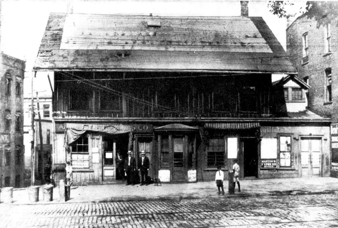
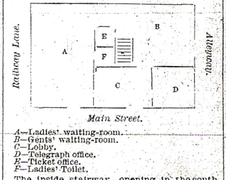
This station stood where the post office is today at 265 Main St., with the rear end of the property reaching all the way to Ives St. The location is shown on the 1856FC map. See Track 10, MP 10.1.3 for more. The railroad commissioners reported in 1884 that the station had been remodeled and improved and it served until 1903 when DANBURY5 opened. The floor plan at lower left shows what the new arrangement was to look like with a new separate waiting room for ladies made possible by moving the Adams Express office elsewhere on the station property. DANBURY1 was razed in 1914: see Track 10, MP 10.7.1. [REFS: DN/03/28/1883/??; CRC31.1884.14][rev060418]
This station stood where the post office is today at 265 Main St., with the rear end of the property reaching all the way to Ives St. The location is shown on the 1856FC map. See Track 10, MP 10.1.3 for more. The railroad commissioners reported in 1884 that the station had been remodeled and improved and it served until 1903 when DANBURY5 opened. The floor plan at lower left shows what the new arrangement was to look like with a new separate waiting room for ladies made possible by moving the Adams Express office elsewhere on the station property. DANBURY1 was razed in 1914: see Track 10, MP 10.7.1. [REFS: DN/03/28/1883/??; CRC31.1884.14][rev060418]
|

|
DANBURY2 [NYH&N, 1869]
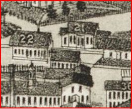
This depot is a bit of an enigma. No photos have been found. The snippet on the left is from the 1883 Bailey bird's-eye map and the smaller structure in front of DANBURY3 and DANBURY4 [locator nos. 21 and 22] may be the elusive station, though it appears larger than we thought. The representation on the 1875 map at the right may be better and may show the NYH&N station, a much smaller structure than the other, at the red arrow. It would be later moved to where the yellow arrow points. [rev112815]
This depot is a bit of an enigma. No photos have been found. The snippet on the left is from the 1883 Bailey bird's-eye map and the smaller structure in front of DANBURY3 and DANBURY4 [locator nos. 21 and 22] may be the elusive station, though it appears larger than we thought. The representation on the 1875 map at the right may be better and may show the NYH&N station, a much smaller structure than the other, at the red arrow. It would be later moved to where the yellow arrow points. [rev112815]

|
|
DANBURY3 [NY&NE, 1881]
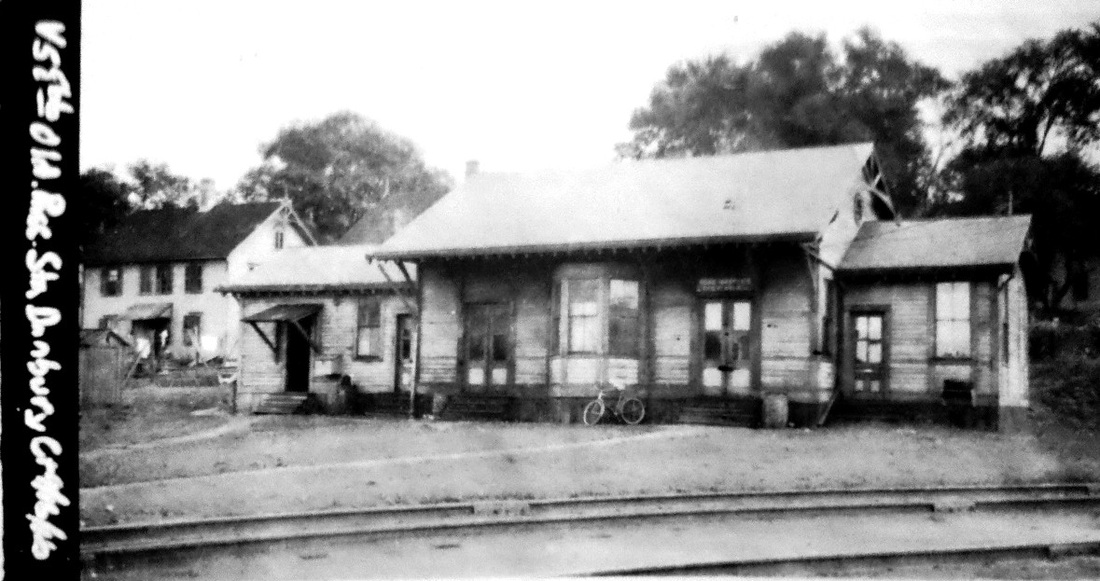
This was among the stations designed and built for the NY&NE by Leman Oatman of Hartford and completed by June of 1881. It is atypical in every way when compared to both the larger stations like SOUTHFORD and the smaller structures like MILL PLAIN. The wings, in particular, are unseen anywhere else. Perhaps the narrowness of the parcel here argued for a more lateral, trackside structure. The only comparable station might be the addition to the 1855 HP&F depot in the Brass City that created WATERBURY4. DANBURY3 would be moved to make room for the 1907 double-tracking of the Maybrook line and would later be sold to Leahy Fuel on whose property it still stands today across from DANBURY5. [REFS: HDC/06/21/1881/02; NL23.1.7; NL23.2.10]
This was among the stations designed and built for the NY&NE by Leman Oatman of Hartford and completed by June of 1881. It is atypical in every way when compared to both the larger stations like SOUTHFORD and the smaller structures like MILL PLAIN. The wings, in particular, are unseen anywhere else. Perhaps the narrowness of the parcel here argued for a more lateral, trackside structure. The only comparable station might be the addition to the 1855 HP&F depot in the Brass City that created WATERBURY4. DANBURY3 would be moved to make room for the 1907 double-tracking of the Maybrook line and would later be sold to Leahy Fuel on whose property it still stands today across from DANBURY5. [REFS: HDC/06/21/1881/02; NL23.1.7; NL23.2.10]

|

|
|
DANBURY4 [HRR, 1882]
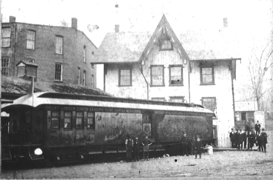
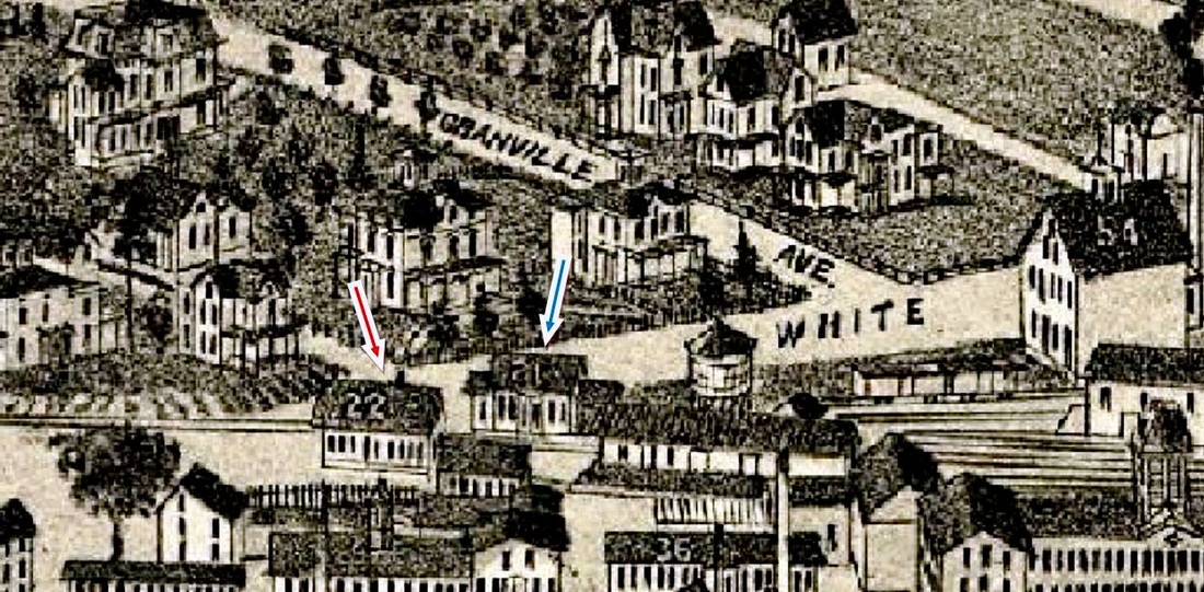
This station took the place of DANBURY2 which had been inherited from the NYH&N at its White St. terminus and characterized by the railroad commissioners as "old and inconvenient" in their 1883 annual report. As seen here at left, it is BROOKFIELD JUNCTION2 after the HRR moved it there in 1889. See B stations and Track 10, MP 10.4.6 for more. No photos have been yet found of this station in its original location, though the shot at middle of DANBURY3, which sat across the track, shows the corner of the DANBURY4 in the extreme left. The Burleigh bird's-eye map of 1884 shows DANBURY4 at the red arrow and DANBURY3 at the blue arrow. [REFS: CRC30.1883.19][rev112815]
This station took the place of DANBURY2 which had been inherited from the NYH&N at its White St. terminus and characterized by the railroad commissioners as "old and inconvenient" in their 1883 annual report. As seen here at left, it is BROOKFIELD JUNCTION2 after the HRR moved it there in 1889. See B stations and Track 10, MP 10.4.6 for more. No photos have been yet found of this station in its original location, though the shot at middle of DANBURY3, which sat across the track, shows the corner of the DANBURY4 in the extreme left. The Burleigh bird's-eye map of 1884 shows DANBURY4 at the red arrow and DANBURY3 at the blue arrow. [REFS: CRC30.1883.19][rev112815]

|
|
|
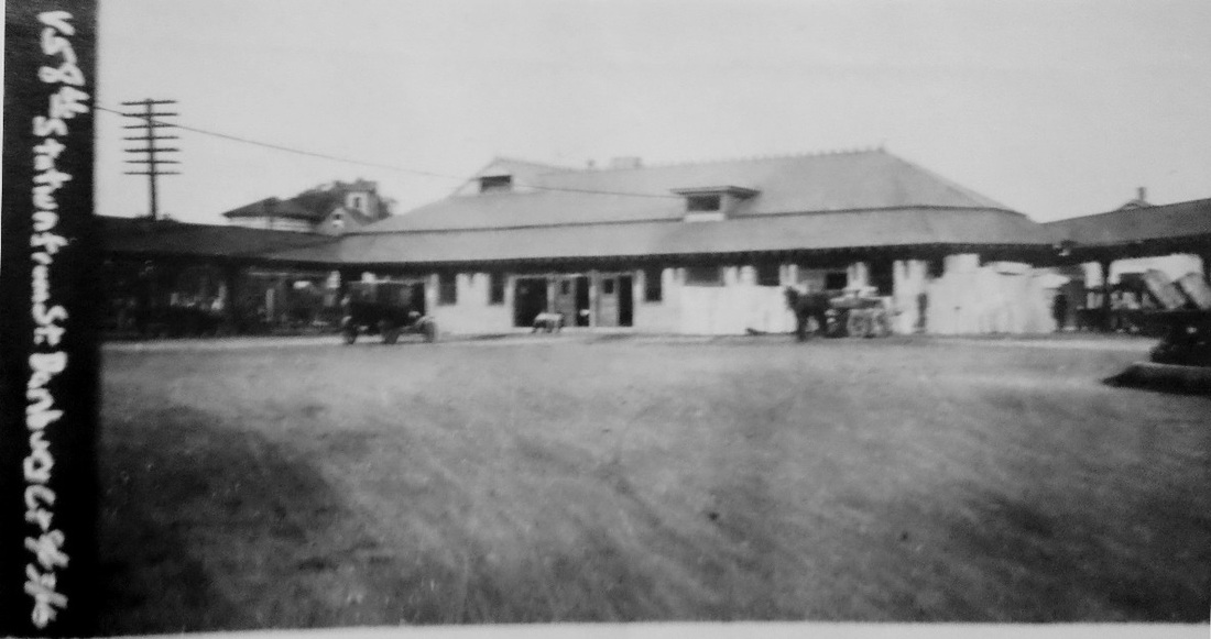
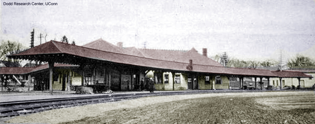
DANBURY5 [NYNH&H, 1903]
This 'union station' was opened on 7/13/1903 by the NYNH&H to bring all its passenger train operations into one location, thereby eliminating DANBURY1 and DANBURY3. After DANBURY5 closed and was taken out of railroad service, it reopened in 1995 as the Danbury Railway Museum and is a popular railfan destination today. [REFS: CRC51.1903.19][rev012919]
This 'union station' was opened on 7/13/1903 by the NYNH&H to bring all its passenger train operations into one location, thereby eliminating DANBURY1 and DANBURY3. After DANBURY5 closed and was taken out of railroad service, it reopened in 1995 as the Danbury Railway Museum and is a popular railfan destination today. [REFS: CRC51.1903.19][rev012919]

DANBURY6 [MN, 1996]
Killingly Historical Society
|

|

|
DANIELSON1 [N&W, 1840]
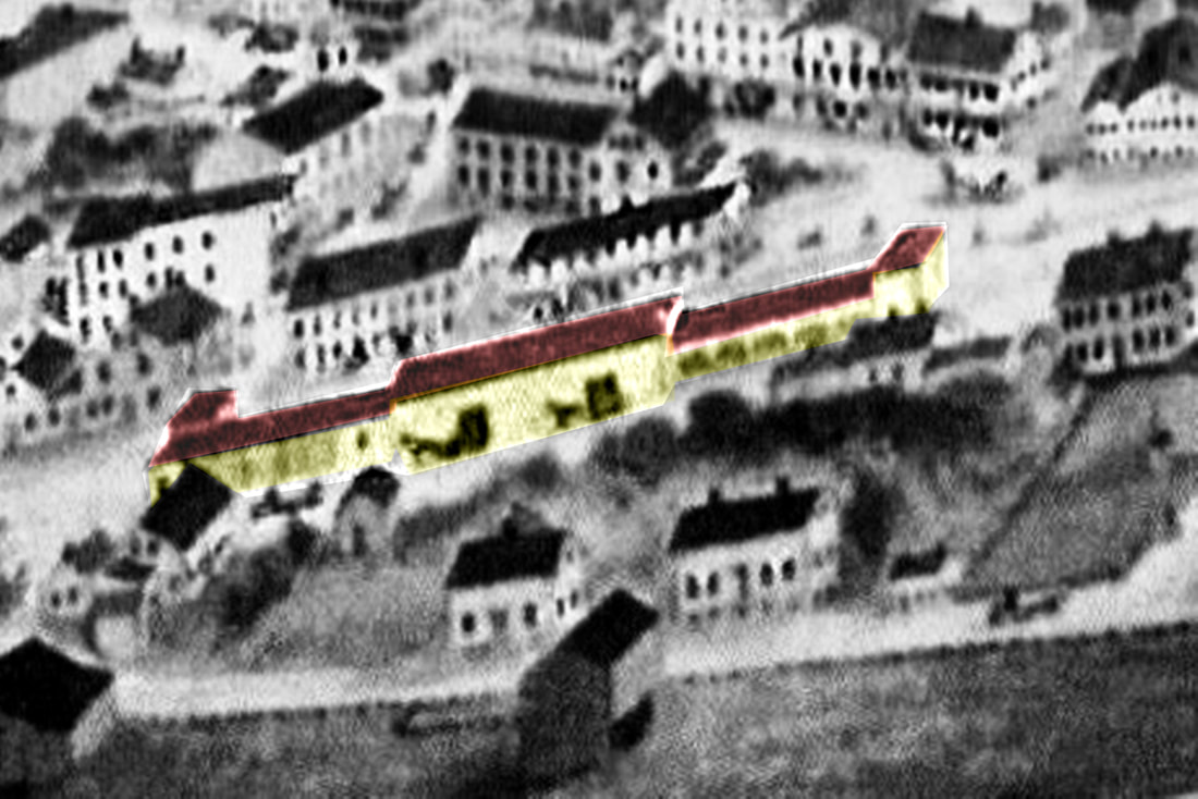
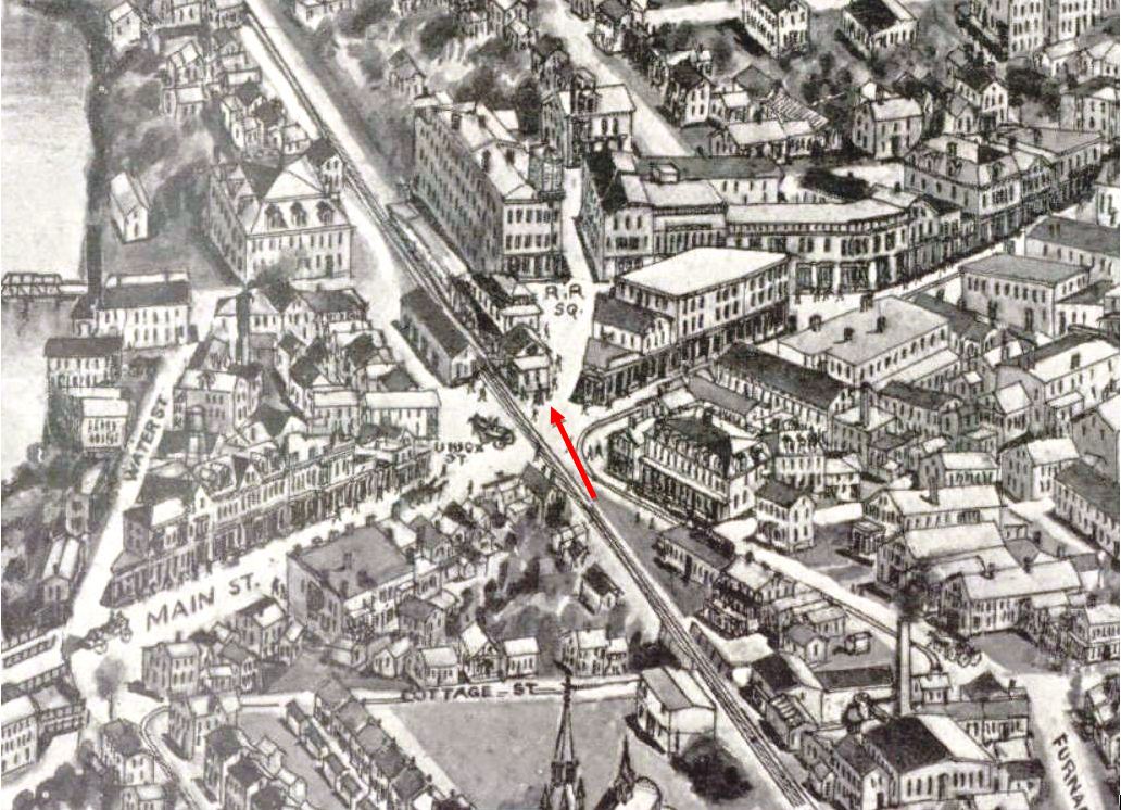
This station in the town of Killingly was first called DANIELSONVILLE and also known as West Killingly for which the post office was later named. The stop was established by the N&W in 1840 and we have a reference to a depot structure as early as a 1/15/1840 article in the Norwich Chronicle. The image at [1] is from the 1864 Albert Conant bird's-eye view of the borough from the west and actually shows both DANIELSON1 and DANIELSON2. As H.V. Arnold explains the buildings seen in this rendering, the first passenger station stood on the west side of the track and "two long sheds projected from either end of the depot and terminated in square-built towers which housed the water tanks. The sheds were for storing wood... for there were no coal-burning engines on the road until 1861... The railroad buildings were clapboarded and painted a brown color." Al Weaver has colorized the station for clarity; the passenger station built in 1839-1840, is in the center. The location is seen on the 1856WC map at [2]. The 1851 timetable at [3] shows DANIELSON to be almost exactly half way between ALLYNS POINT and WORCESTER. An ideal place for water and wood refueling, the boat train made this its sole stop on the express run between the two termini. This station became the freight depot in 1860 when DANIELSON2 debuted. [REFS: NC/01/15/1840/00; HDC/08/07/1854/02; Q145; Henry Vernon Arnold, Bird's-eye View of Danielson Borough: An Explanation... (1926), p14][rev020519]
This station in the town of Killingly was first called DANIELSONVILLE and also known as West Killingly for which the post office was later named. The stop was established by the N&W in 1840 and we have a reference to a depot structure as early as a 1/15/1840 article in the Norwich Chronicle. The image at [1] is from the 1864 Albert Conant bird's-eye view of the borough from the west and actually shows both DANIELSON1 and DANIELSON2. As H.V. Arnold explains the buildings seen in this rendering, the first passenger station stood on the west side of the track and "two long sheds projected from either end of the depot and terminated in square-built towers which housed the water tanks. The sheds were for storing wood... for there were no coal-burning engines on the road until 1861... The railroad buildings were clapboarded and painted a brown color." Al Weaver has colorized the station for clarity; the passenger station built in 1839-1840, is in the center. The location is seen on the 1856WC map at [2]. The 1851 timetable at [3] shows DANIELSON to be almost exactly half way between ALLYNS POINT and WORCESTER. An ideal place for water and wood refueling, the boat train made this its sole stop on the express run between the two termini. This station became the freight depot in 1860 when DANIELSON2 debuted. [REFS: NC/01/15/1840/00; HDC/08/07/1854/02; Q145; Henry Vernon Arnold, Bird's-eye View of Danielson Borough: An Explanation... (1926), p14][rev020519]

Killingly Historical Society
|
|
|
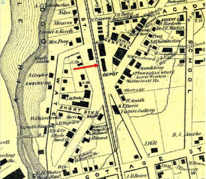
DANIELSON2 [N&W, 1860]
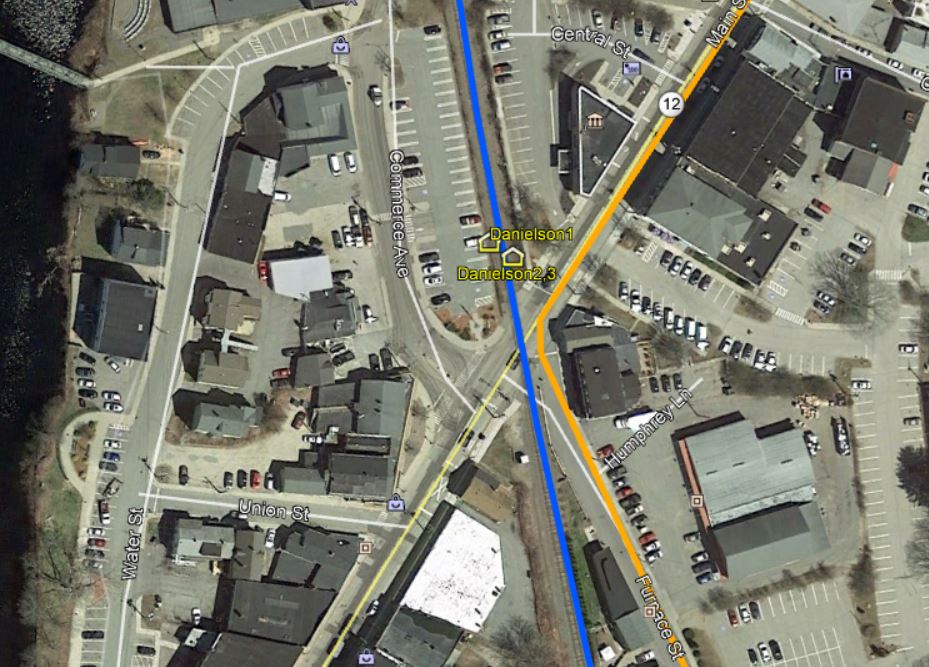
Again according to Arnold, Sylvanus Gleason became station agent in 1858 and was instrumental in making changes to the station grounds and structures, so in 1860... "a substantial two-story depot was erected where the removed freight house [slightly to the north?] had stood. It was not clapboarded, but sheathed outside with flooring material painted a drab color and sanded over. Below the upper story windows a porch roof protected the platforms on the track side and the south end." Al WEaver's colorization makes these details quite clear in the image at [1]. The structure, now on the east side of the tracks, has the covershed on the west and south sides just as Arnold describes. The 1869 map at [2] verifies the relocation of the passenger depot. Arnold claims this depot burned in June, 1876 but the newspapers say it was at midnight on 3/9/1876 when all the adjacent railroad structures went up in flames. Gleason himself, then retired and "living in Washington [RI?]" was said to own the depot buildings and to have suffered a loss of $20,000. This apparently is another interesting example of private ownership of structures that railroads used by gift or lease, in many cases reverting back to the original owner when train service ended, e.g. ORANGE on the NH&D. The snippet from our Track 11 Google Earth map shows the active rail today in blue and the former trolley line, which ran from 1902 to 1920, in orange. [REFS: BT/03/09/1876/02; NA/03/10/1876/02; CRC24.1877.26; Arnold, p14-16][rev012819]
Again according to Arnold, Sylvanus Gleason became station agent in 1858 and was instrumental in making changes to the station grounds and structures, so in 1860... "a substantial two-story depot was erected where the removed freight house [slightly to the north?] had stood. It was not clapboarded, but sheathed outside with flooring material painted a drab color and sanded over. Below the upper story windows a porch roof protected the platforms on the track side and the south end." Al WEaver's colorization makes these details quite clear in the image at [1]. The structure, now on the east side of the tracks, has the covershed on the west and south sides just as Arnold describes. The 1869 map at [2] verifies the relocation of the passenger depot. Arnold claims this depot burned in June, 1876 but the newspapers say it was at midnight on 3/9/1876 when all the adjacent railroad structures went up in flames. Gleason himself, then retired and "living in Washington [RI?]" was said to own the depot buildings and to have suffered a loss of $20,000. This apparently is another interesting example of private ownership of structures that railroads used by gift or lease, in many cases reverting back to the original owner when train service ended, e.g. ORANGE on the NH&D. The snippet from our Track 11 Google Earth map shows the active rail today in blue and the former trolley line, which ran from 1902 to 1920, in orange. [REFS: BT/03/09/1876/02; NA/03/10/1876/02; CRC24.1877.26; Arnold, p14-16][rev012819]
Killingly Historical Society
|
|
|
|
Max Miller Collection
|
Killingly Historical Society
|
 Killingly Historical Society
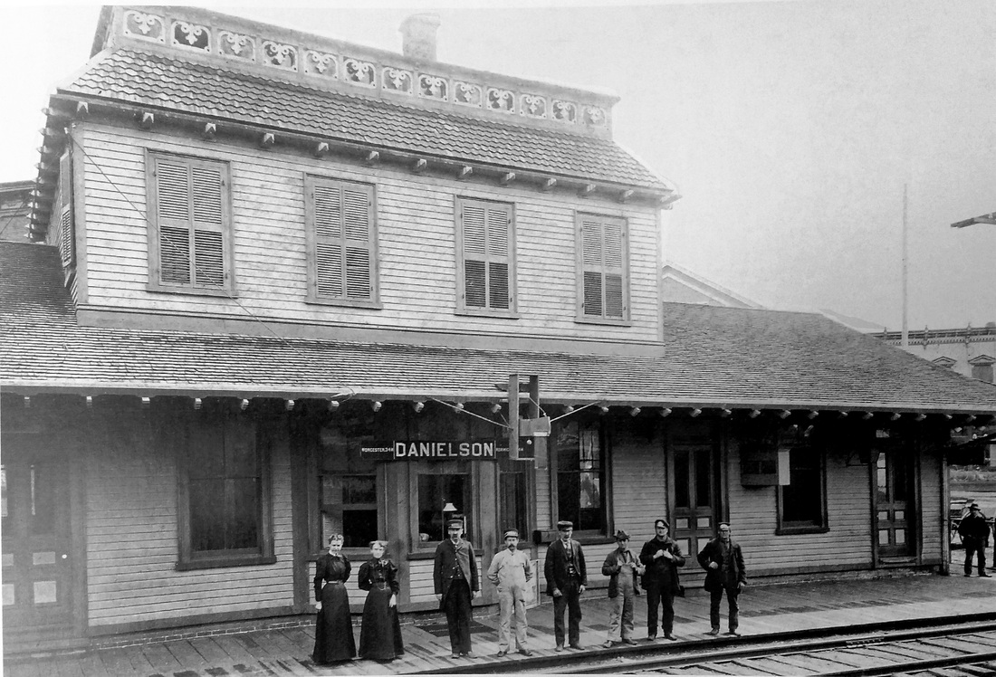
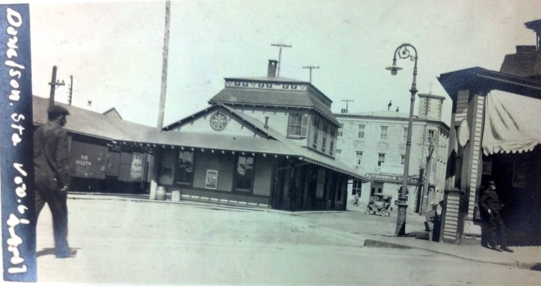
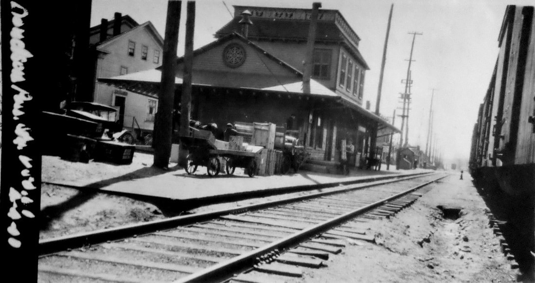
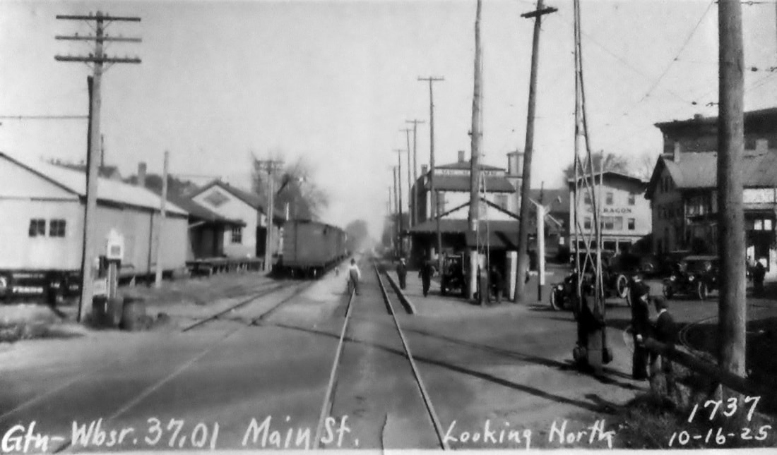
DANIELSON3 [N&W, 1877]
After the 3/9/1876 fire that took the previous station, the N&W built a new depot here that the railroad commissioners report was nearly complete in January, 1877. The NY&NE was leasing the N&W at the time and apparently did not feel as though it was their responsibility and thus provided no assistance and, according to Farnham, that position was later upheld in court. In the meantime, however, a letter to Railroad Commissioner Henry Hammond complained in August, 1876 of the absence of a passenger station that town officials said they were entitled to have had three months ago. The shot at [1] is from the 1900s and shows the new station, with its distinctive second-story dormer, standing like its predecessor on the east side of the tracks. The rather distinctive "wedding cake" architecture has yet to be explained to us, as do the porthole windows (stained glass?) in the north and south eaves. The snippet at [2] is from the Bailey map of 1913. The Providence & Danielson street railway line to the right of our arrow is also seen. The railroad station itself seems to be larger with an additional baggage room on the south end. The val photos at [3] and [4] are dated 4/4/1917 and look north and south respectively. The northward PUC shot at [5] was taken on 10/14/1923; if you look at the extreme lower right, you can see the trolley track. We do not yet know when and under what circumstances DANIELSON3 met its fate; 'Doodlebug' passenger service was eliminated on the N&W line in 1928. The historical society has just shared a photo of the depot in the winter of 1933, perhaps the last image we have of this station. The shot at [7] shows it was no longer standing on 6/9/1952 behind the "Budd Car Reception Committee" when service was resumed by the NYNH&H. The stop did not make it into Amtrak in May, 1971 when the new corporate entity declined to include the N&W in its system. [REFS: RRL: 8/2/1876; CRC24.1877.26; B389; K108; Q145] [rev020519]
After the 3/9/1876 fire that took the previous station, the N&W built a new depot here that the railroad commissioners report was nearly complete in January, 1877. The NY&NE was leasing the N&W at the time and apparently did not feel as though it was their responsibility and thus provided no assistance and, according to Farnham, that position was later upheld in court. In the meantime, however, a letter to Railroad Commissioner Henry Hammond complained in August, 1876 of the absence of a passenger station that town officials said they were entitled to have had three months ago. The shot at [1] is from the 1900s and shows the new station, with its distinctive second-story dormer, standing like its predecessor on the east side of the tracks. The rather distinctive "wedding cake" architecture has yet to be explained to us, as do the porthole windows (stained glass?) in the north and south eaves. The snippet at [2] is from the Bailey map of 1913. The Providence & Danielson street railway line to the right of our arrow is also seen. The railroad station itself seems to be larger with an additional baggage room on the south end. The val photos at [3] and [4] are dated 4/4/1917 and look north and south respectively. The northward PUC shot at [5] was taken on 10/14/1923; if you look at the extreme lower right, you can see the trolley track. We do not yet know when and under what circumstances DANIELSON3 met its fate; 'Doodlebug' passenger service was eliminated on the N&W line in 1928. The historical society has just shared a photo of the depot in the winter of 1933, perhaps the last image we have of this station. The shot at [7] shows it was no longer standing on 6/9/1952 behind the "Budd Car Reception Committee" when service was resumed by the NYNH&H. The stop did not make it into Amtrak in May, 1971 when the new corporate entity declined to include the N&W in its system. [REFS: RRL: 8/2/1876; CRC24.1877.26; B389; K108; Q145] [rev020519]
Darien Historical Society
|

|
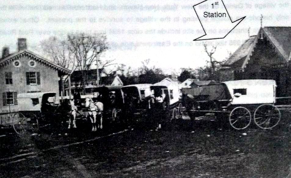
DARIEN1 [NY&NH, 1848, EB]
The stop was established in 1848 by the NY&NH. The first depot here, seen in the photo at left [add070113] was a cross-gabled Gothic structure like GREENWICH1, MILFORD1 and virtually all the other original stations on the line. The location, on the eastbound side of the line that was double-tracked in 1859, is seen on the 1874 map. [REFS: R46 says 1885 fire took saltbox depot(?)][rev070113]
The stop was established in 1848 by the NY&NH. The first depot here, seen in the photo at left [add070113] was a cross-gabled Gothic structure like GREENWICH1, MILFORD1 and virtually all the other original stations on the line. The location, on the eastbound side of the line that was double-tracked in 1859, is seen on the 1874 map. [REFS: R46 says 1885 fire took saltbox depot(?)][rev070113]
|

C. Dunn Collection
|
Dave Peters Collection
|
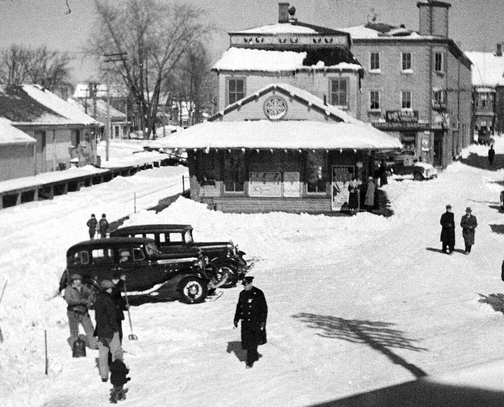
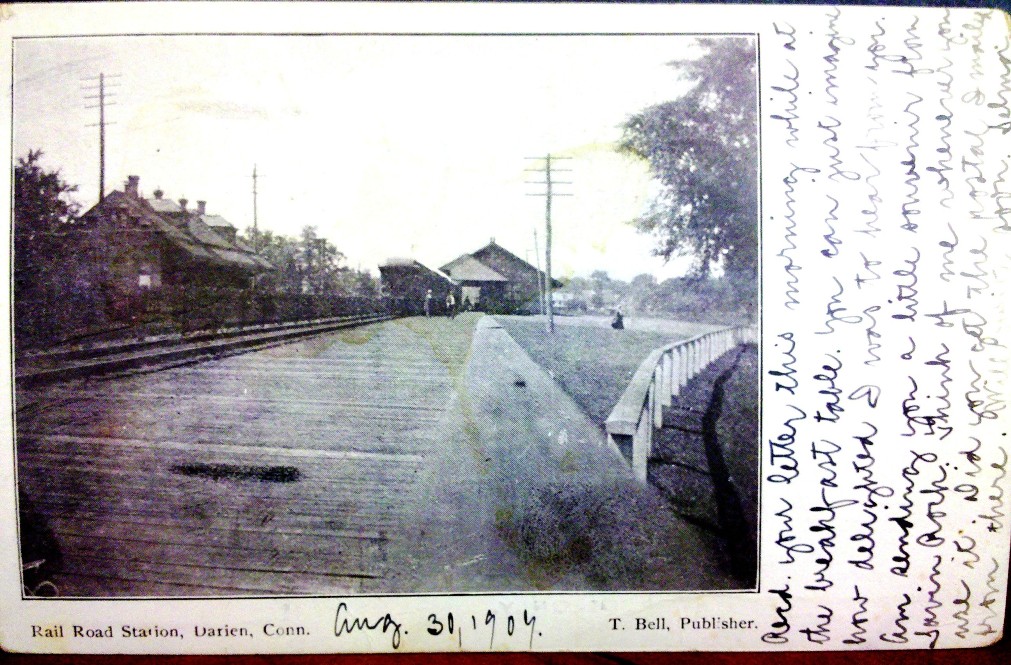
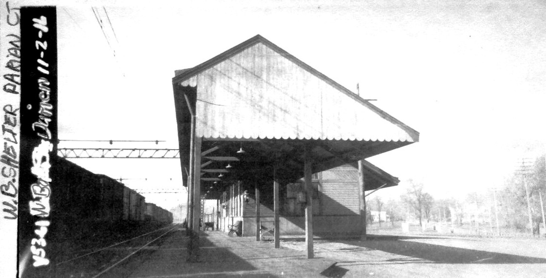
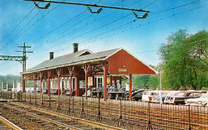
DARIEN2 [NYNH&H, 1885, EB]
The new depot is seen at left in a 1907 post card and in the 11/2/1916 val photo at right, as well as a side view in the middle shot. The Register reported in June, 1885 that a replacement depot was being built for the burned-out DARIEN1. With the exception of the dormers added here, the new brick station was similar to others of the period, FAIRFIELD2 and MILFORD2, and cost $6,800. As reported in the Stamford Advocate in a "Fifty Years Ago" item, DARIEN2 also burned in a 3/6/1935 fire that did $20,000 worth of damage and caused the railroad to shut down power to the tracks. The station was torn down and replaced by a small brick building that is seen below as DARIEN4. [REFS: NHER/06/03/1885/01; NHAR14.1886.11; NL17.8.10; R46][rev100312]
The new depot is seen at left in a 1907 post card and in the 11/2/1916 val photo at right, as well as a side view in the middle shot. The Register reported in June, 1885 that a replacement depot was being built for the burned-out DARIEN1. With the exception of the dormers added here, the new brick station was similar to others of the period, FAIRFIELD2 and MILFORD2, and cost $6,800. As reported in the Stamford Advocate in a "Fifty Years Ago" item, DARIEN2 also burned in a 3/6/1935 fire that did $20,000 worth of damage and caused the railroad to shut down power to the tracks. The station was torn down and replaced by a small brick building that is seen below as DARIEN4. [REFS: NHER/06/03/1885/01; NHAR14.1886.11; NL17.8.10; R46][rev100312]

|
|
iridetheharlemline.com
|

|
|
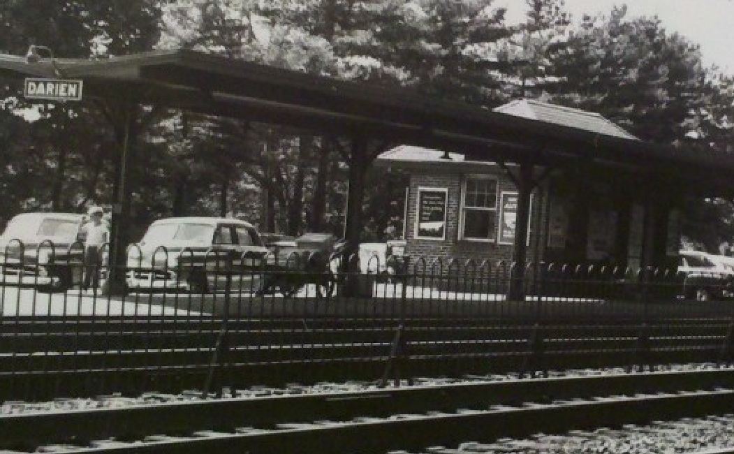
DARIEN3 [NYNH&H, c1896, WB]
This the saltbox structure, refurbished in 2002, is still standing on the westbound side of the tracks. We are inclined to think that DARIEN3 was built ca. 1896. John Roy puts the build date between 1870 and 1885 and he says there was a somewhat larger saltbox on the eastbound side. We are unaware of any other locations on the New York line that had depots on both sides of the tracks before the four-tracking of the 1890s. [REFS: R46]
This the saltbox structure, refurbished in 2002, is still standing on the westbound side of the tracks. We are inclined to think that DARIEN3 was built ca. 1896. John Roy puts the build date between 1870 and 1885 and he says there was a somewhat larger saltbox on the eastbound side. We are unaware of any other locations on the New York line that had depots on both sides of the tracks before the four-tracking of the 1890s. [REFS: R46]
|

|
DARIEN4 [NYNH&H, 1935, EB]
This small brick station replaced DARIEN2 on the eastbound side in 1935 and was razed in 2002 with the station renovation project here. [REFS: R46]
This small brick station replaced DARIEN2 on the eastbound side in 1935 and was razed in 2002 with the station renovation project here. [REFS: R46]

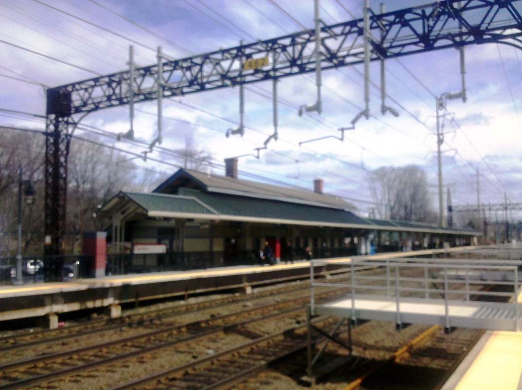
DARIEN5 [MN, 2002, EB]
|
|

|
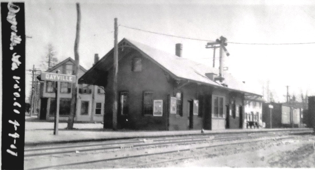
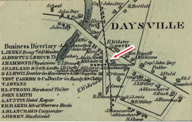
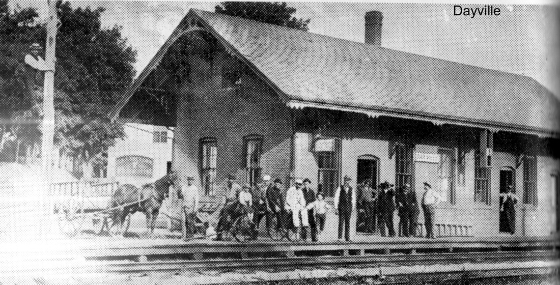
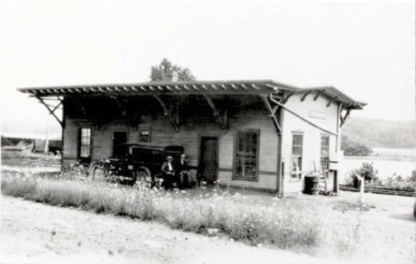
DAYVILLE [N&W, 1840]
This station, also called DAYSVILLE, is seen on the 1856WC map and in several photos. The stop was established in the town of Killingly by the N&W in 1840. This is the only station we have found pictured at this location, though it is possible that there was an earlier one here. The 1938 SSRR list has this station still owned by the railroad but up for retirement and removal. [REFS: Q530-l][rev010318, 122022]
This station, also called DAYSVILLE, is seen on the 1856WC map and in several photos. The stop was established in the town of Killingly by the N&W in 1840. This is the only station we have found pictured at this location, though it is possible that there was an earlier one here. The 1938 SSRR list has this station still owned by the railroad but up for retirement and removal. [REFS: Q530-l][rev010318, 122022]

|
|

|
DEEP RIVER [CV, 1871]
The map is from the 1874 Middlesex County atlas, when this village was within the township of Saybrook, not to be confused with Old Saybrook to the south; Deep River would become an independent town in 1947. This classic CV passenger station was up for the opening of the CV in 1871, a replacement planned in 1905 was never built. The 1938 SSRR list says this station has been sold. Max Miller says it was razed in January, 1939. The 1890 freight house here still stands in 2018. [REFS: R47; HDC/08/25/1871/02; HC/08/17/1905/12; ATVL, p35][rev011218]
The map is from the 1874 Middlesex County atlas, when this village was within the township of Saybrook, not to be confused with Old Saybrook to the south; Deep River would become an independent town in 1947. This classic CV passenger station was up for the opening of the CV in 1871, a replacement planned in 1905 was never built. The 1938 SSRR list says this station has been sold. Max Miller says it was razed in January, 1939. The 1890 freight house here still stands in 2018. [REFS: R47; HDC/08/25/1871/02; HC/08/17/1905/12; ATVL, p35][rev011218]
|

|
Jack Vagnini Collection
|

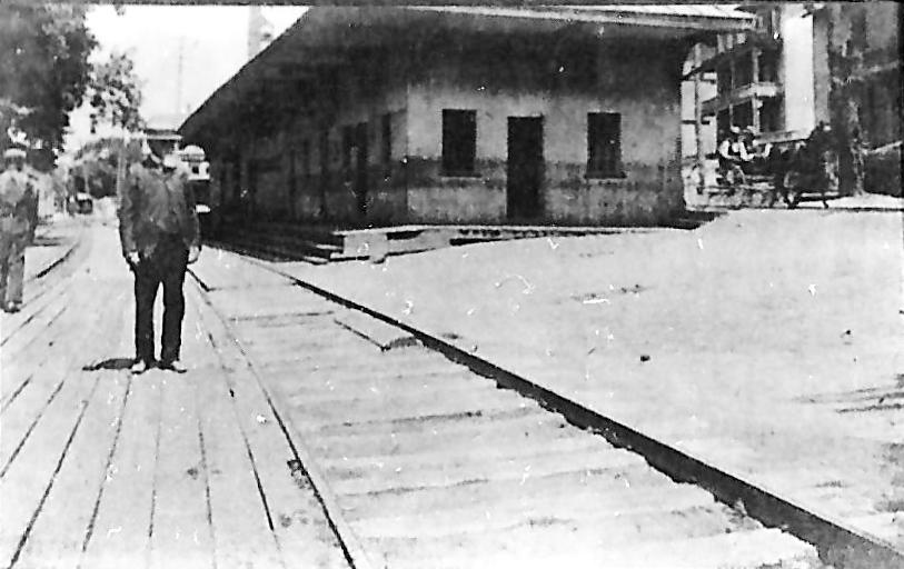
DERBY1 [NRR, 1849]
This was the NRR's original Derby station located east of Naugatuck River at the end of the causeway and bridge that led to Birmingham, today's downtown Derby. This stop was renamed EAST DERBY by the NYNH&H in 1896, when BIRMINGHAM2 was named DERBY. EAST DERBY was abandoned on 8/12/1904 "... after taking the steps required by statute applicable to such cases, said company having provided and opened a new station for the use of the public on the new line of its railroad." The new station was, of course, DERBY3 which opened late in 1903. The man in the foreground in the northward-looking photo at [1] is William Blakeman, long-time resident and merchant. The team in background belongs to W. M. Bradley. The view at [2] looks south from the causeway; note the box cars spotted below the depot. The image at [3] captures the railing of the bridge which is more or less today's Rte 34 crossing of the Naugatuck River. The view at [4] looks north and may date to the 1880s judging by the simple dress style. Note the dangerously curved house track in front of the station! [REFS: HC/06/26/1896/11; HC/06/30/1904/03; RRC20.311 (8/12/1904); CRC52.1904.08][rev121614, 111918, 110520, 111320]
This was the NRR's original Derby station located east of Naugatuck River at the end of the causeway and bridge that led to Birmingham, today's downtown Derby. This stop was renamed EAST DERBY by the NYNH&H in 1896, when BIRMINGHAM2 was named DERBY. EAST DERBY was abandoned on 8/12/1904 "... after taking the steps required by statute applicable to such cases, said company having provided and opened a new station for the use of the public on the new line of its railroad." The new station was, of course, DERBY3 which opened late in 1903. The man in the foreground in the northward-looking photo at [1] is William Blakeman, long-time resident and merchant. The team in background belongs to W. M. Bradley. The view at [2] looks south from the causeway; note the box cars spotted below the depot. The image at [3] captures the railing of the bridge which is more or less today's Rte 34 crossing of the Naugatuck River. The view at [4] looks north and may date to the 1880s judging by the simple dress style. Note the dangerously curved house track in front of the station! [REFS: HC/06/26/1896/11; HC/06/30/1904/03; RRC20.311 (8/12/1904); CRC52.1904.08][rev121614, 111918, 110520, 111320]
DERBY2
This was BIRMINGHAM2 that was renamed DERBY in 1893 when the 5.3-sq. mile borough of Birmingham was incorporated as the town of Derby.

|
|
Tom Nelligan photo
|
 Jack Vagnini Collection
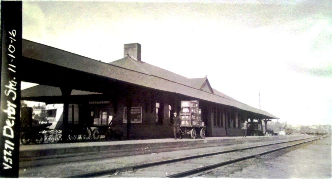
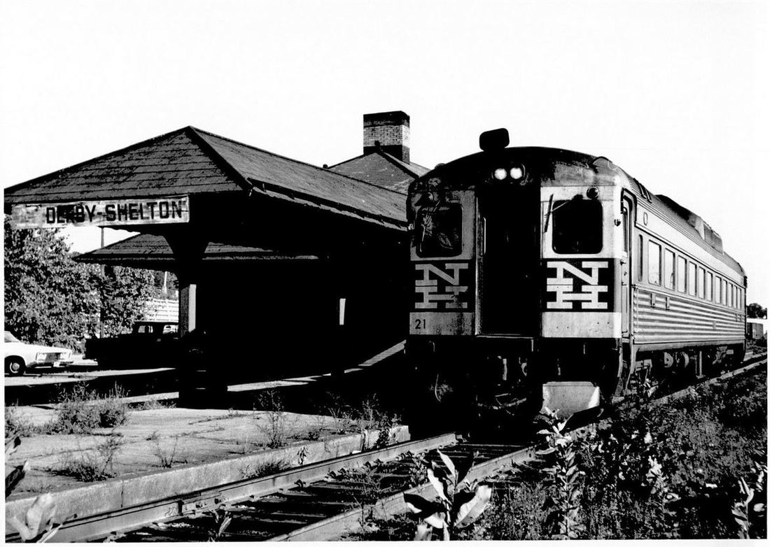
DERBY3 [NYNH&H, 1903]
This station opened on 10/18/1903 to replace DERBY2. The architectural drawing at [4] is dated 10/1902 for this station that had been long in the planning. The circled '190' at bottom center makes it look like this came from a book of architectural plans in the railroad's real estate office. The view at [1] looks pretty clean and was possibly taken right around the 1903 opening. The ICC valuation photo at [2] is dated 11/10/1916. Tom Nelligan took the photo at [3] of RDC-1, #21, on 9/3/1967. See Track 4C, MP 4.63.3+ for much more. [REFS: CRC51.1903.20][rev111918, 101320, 040123]
This station opened on 10/18/1903 to replace DERBY2. The architectural drawing at [4] is dated 10/1902 for this station that had been long in the planning. The circled '190' at bottom center makes it look like this came from a book of architectural plans in the railroad's real estate office. The view at [1] looks pretty clean and was possibly taken right around the 1903 opening. The ICC valuation photo at [2] is dated 11/10/1916. Tom Nelligan took the photo at [3] of RDC-1, #21, on 9/3/1967. See Track 4C, MP 4.63.3+ for much more. [REFS: CRC51.1903.20][rev111918, 101320, 040123]
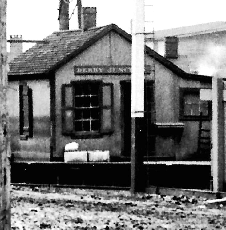
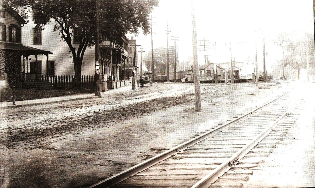
DERBY JUNCTION1 [NH&D, 1871]
A small station was located here where the NH&D met and crossed the NRR on the east bank of the Housatonic River just below its confluence with the Naugatuck River. It is unclear as to how much interchange of passengers and freight took place here from 1871 until the hostile NRR was browbeaten into pooling freight with the Derby road in 1880. At that time, a newer station was built and this one was moved a little south and repurposed. The stop was called DERBY on the NH&D timetables until 1889. [rev121514]
A small station was located here where the NH&D met and crossed the NRR on the east bank of the Housatonic River just below its confluence with the Naugatuck River. It is unclear as to how much interchange of passengers and freight took place here from 1871 until the hostile NRR was browbeaten into pooling freight with the Derby road in 1880. At that time, a newer station was built and this one was moved a little south and repurposed. The stop was called DERBY on the NH&D timetables until 1889. [rev121514]
|
|
|
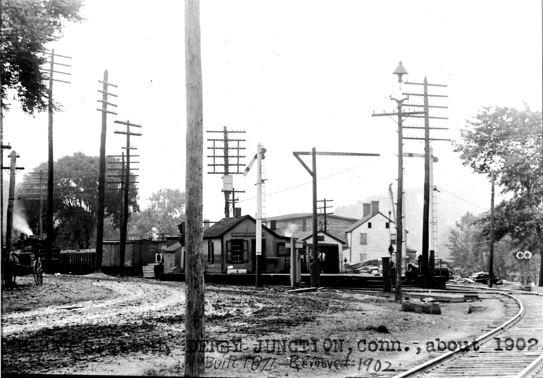
DERBY JUNCTION2 [NH&D, 1880]
This station was built early in 1880 as part of the improved facilities to implement the new pooling agreement. By 1889, this DERBY stop begins to appear as DERBY JUNCTION, probably to honor the fact that the Extension had opened in 1888 and now this was a junction of two NH&D lines. As noted above, the intersection with the NRR was here from the start. [rev121514]
This station was built early in 1880 as part of the improved facilities to implement the new pooling agreement. By 1889, this DERBY stop begins to appear as DERBY JUNCTION, probably to honor the fact that the Extension had opened in 1888 and now this was a junction of two NH&D lines. As noted above, the intersection with the NRR was here from the start. [rev121514]
DEVON [> NAUGATUCK JUNCTION]

DIVIDEND1 [NYNH&H, c1900]
This small station on the CV in the southern part of Rocky Hill was not established until ca. 1900 and is found on our 1907 and 1911TTs. The layout on the 1915 valuation map shows a small depot structure. We have no photo yet of whatever stood here. The village was so named because parcels of land were extended at one time producing an increase in the value of the properties, a dividend. [rev121614, 101320]
This small station on the CV in the southern part of Rocky Hill was not established until ca. 1900 and is found on our 1907 and 1911TTs. The layout on the 1915 valuation map shows a small depot structure. We have no photo yet of whatever stood here. The village was so named because parcels of land were extended at one time producing an increase in the value of the properties, a dividend. [rev121614, 101320]
|
|

|
DIVIDEND2 [NYNH&H, 1924]
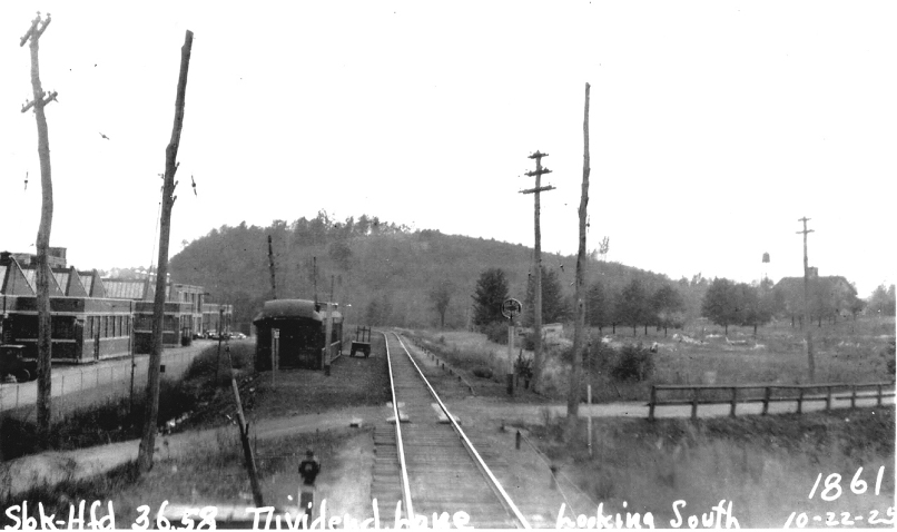
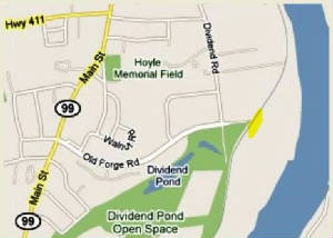
The stop was renamed BELAMOSE, probably in March, 1924. According to the Hartford Times, the name change was for the company that built extensive factory facilities in Rocky Hill for the production of artificial silk. The PUC photographer took the shot at [1] on 10/22/1925 when the state railroad commissioners were examining the Valley Branch grade crossings, this one 36.58 miles from Fenwick. The new station is the wooden combine coach seen in the photo that looks south from Old Forge Rd/Dividend La., shown at the yellow mark on the present-day map at [2]. BELAMOSE is listed in a NYNH&H station index of 8/1/1925 and is seen on the 1930RAM map at [3]. The old coach doing the honors was built in 1892 by the Wason Car Co. Having served as NYNH&H #1725 and then as #2501, it was condemned on 2/16/1925 and moved here at the request of the company to serve the Belamose employees. The coach was retired on 3/25/1929, moved down the track by a wrecker, pushed over the bank and burned. The Belamose company was Rocky Hill's largest taxpayer for many years and in 1932 had 400 employees. The factory property passed to Bigelow-Sanford, later to American Enka, and finally was donated to the town on 1/1/1966 when the latter company shut down operations. We do not know if anything replaced the coach for workers commuting here after 1929. Our thanks to the Rocky Hill Historical Society and to Max Miller for details about the coach. [REFS: HC/08/30/1923/17; HC/11/20/1923/01; HC/06/19/1924/10 HC/06/23/1924/13; HT/03/16/1924(?)/00; HC/09/22/1932/18; HC/12/30/1965/26A; Miller, Along the Valley Line, p17-18: AFE #24595][rev022720, 101320]
The stop was renamed BELAMOSE, probably in March, 1924. According to the Hartford Times, the name change was for the company that built extensive factory facilities in Rocky Hill for the production of artificial silk. The PUC photographer took the shot at [1] on 10/22/1925 when the state railroad commissioners were examining the Valley Branch grade crossings, this one 36.58 miles from Fenwick. The new station is the wooden combine coach seen in the photo that looks south from Old Forge Rd/Dividend La., shown at the yellow mark on the present-day map at [2]. BELAMOSE is listed in a NYNH&H station index of 8/1/1925 and is seen on the 1930RAM map at [3]. The old coach doing the honors was built in 1892 by the Wason Car Co. Having served as NYNH&H #1725 and then as #2501, it was condemned on 2/16/1925 and moved here at the request of the company to serve the Belamose employees. The coach was retired on 3/25/1929, moved down the track by a wrecker, pushed over the bank and burned. The Belamose company was Rocky Hill's largest taxpayer for many years and in 1932 had 400 employees. The factory property passed to Bigelow-Sanford, later to American Enka, and finally was donated to the town on 1/1/1966 when the latter company shut down operations. We do not know if anything replaced the coach for workers commuting here after 1929. Our thanks to the Rocky Hill Historical Society and to Max Miller for details about the coach. [REFS: HC/08/30/1923/17; HC/11/20/1923/01; HC/06/19/1924/10 HC/06/23/1924/13; HT/03/16/1924(?)/00; HC/09/22/1932/18; HC/12/30/1965/26A; Miller, Along the Valley Line, p17-18: AFE #24595][rev022720, 101320]